Introduction to Safety on Glaciers in Svalbard
|
|
|
- Fay Hunt
- 5 years ago
- Views:
Transcription
1 Introduction to Safety on Glaciers in Svalbard
2 Content Basic info on Svalbard glaciers Risk aspects when travelling on glaciers Safe travel on glaciers UNIS safety & rescue equipment Companion rescue in crevasse accidents

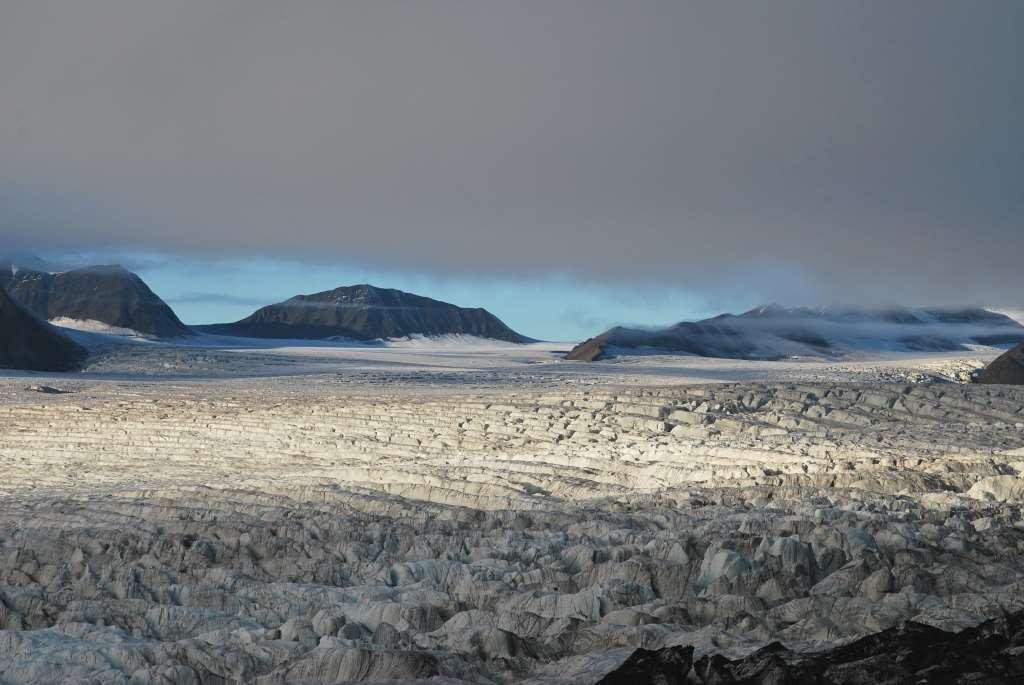
3 Some basic Info 60 % of Svalbard is covered by glaciers Distribution: Most glacier terrain in North- East Also lot in Southern and North-West side Least around Longyearbyen Differences in weather, amount of precipitation Many snowmobile routes cross over glaciers you need to use them if you want to travel longer distances Very nice and flat terrain to use with snowmobiles and skis Fascinating terrain
4 accumulation area = glacier gets thicker Equilibrium line = all snow melts in summer ablation area = glacier melts and gets thinner Slow plastic flow downwards following and forming the terrain constant change Illustration: K. Bælum

5 Glacier basics Glacier zones in summer Accumulation snow year round Equilibrium area Ablation no snow in summer
6 Glaciers different types Glacier plateaus Fonna high up between the mountains Large valley glaciers flowing out to sea with active glacier front
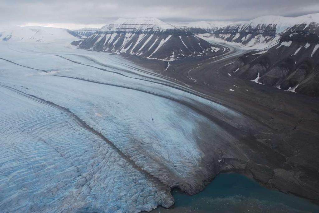
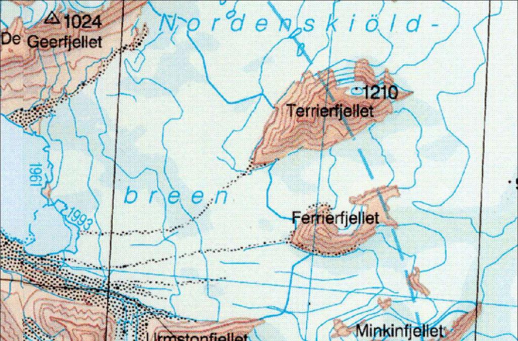
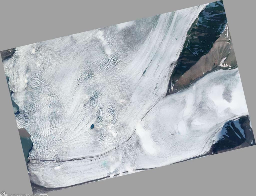
7 Nordenskiöldbreen in Billefjorden

8 Glaciers different types Small alpine hanging glaciers on steep mountainsides Smaller valley glaciers flowing out to valley bottoms with smooth front behind moraines
9 Longyearbreen
10 Surging glaciers More ice & mass builds up equilibrium line Lower areas melt and shrink Glacier moves slower than needed to keep the balance between accumulation and melting areas more mass on upper areas Illustration: K. Bælum
11 Surging glaciers At some point the unbalance gets too big and the glacier starts moving unusually fast SURGE Build up take tens of years years and surge many years or many shorter periods of time changing the character of glacier dramatically Illustration: K. Bælum
12 Surging glaciers

13 Surging glaciers


14 Surging glaciers - Freemanbreen 1936 Norwegian Polar Institute 1956 Norwegian Polar Institute

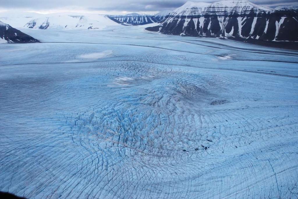
15 Surging glaciers - Skobreen Paulabreen Skobreen Very broken up surface Affects the movement and balance of surrounding glaciers as well expect more cracks and movement Photo M. Sund
16
17 Risk aspects on glaciers
18 Risk aspects on glaciers 1. Crevasses (cracks on the surface)

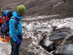
19 Crevasses (cracks on the surface) Glacier ice is huge plastic mass moving slowly over underlying terrain this causes stresses, forces and different speeds in the ice surface when the contours of underlying terrain changes and also when glacier changes direction Photo: K. Bælum
20 Below mountainside, Bergschrund. Dome on the bed rock, uplift. Chaotic crevasse pattern Steep section, icefall, Extensional crevasses Inside of turn, crevasses Narrowing of the cross profile, transversal crevasses Widening of the cross profile. Extensional crevasses along flow lines Front and sides of glacier, marginal crevasses
21
22

23 Some possible crevasse risk areas Most crevasses on places where glacier changes its character considerably fronts, steeper, convex, curve, get narrow, widens up, splits in two, by mountainsides Safest on flat areas high up away from glacier fronts and mountain sides (no stress on ice, most snow)
24
25
26

27 Front in Tunabreen

28 Calving active glacier fronts also in winter Calving Tunabreen March 201
29 Large calving can break the sea ice Calving site 500m away Calving Tunabreen March Sea ice 50-60cm thick, cracked up 200m away from the front in deep water 600m away in shallow parts because of waves created by calving.

30 Risk aspects on glaciers 2. Melt water channels Svalbard glaciers have melt water channels on surface very often on the sides, following moraine ridges etc. Large and deep close to glacier fronts + terminal moraine Large changes from year to year

31 Melt water channels Von Post Front

32 Melt water channel following moraine feature

33 Melt water channels following moraine features

34 Collapsed melt water channel/cave feature Large changes from year to year
35 Glacier risk areas by Longyearbyen Crevasse area Melt water hole Melt water channel
36 Glacier melt water channels in Longyearbreen Channels along sides of Longyearbreen; some places 5-10m deep
37


38 Crevasse and melt water channels on Larsbreen

39 Crevasses below Nordenskiöldtoppen Large crevasse with thin snow bridge
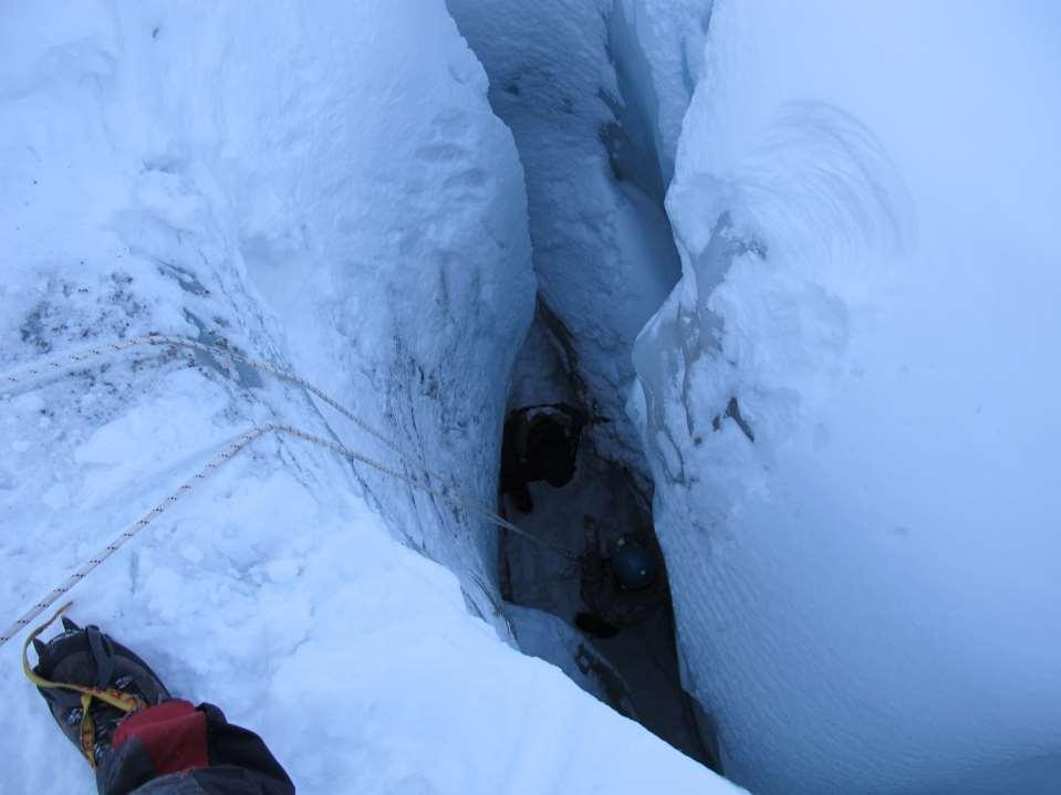
40 Part of melt water channels Mostly dry in winter Accessible in many glaciers: Longyearbre, Larsbre, Tellbre.. Big changes every year Ice caves in Glaciers Possible risks Collapsing parts of wall, roof, floor Slippery, sliding and hitting yourself Falling Calling for help difficult Rescue work very difficult 2011 large collapse in Longyearbreen cave, unstable conditions in many others
41 Ice caves in Glaciers


42 Ice caves in Glaciers Safety measures Check conditions some caves and some years need to use ropes and other gear to get safely down into caves and up again Use helmet Bring with you crampons Look around for cracks, loose parts of ice on the walls and roof Also pay attention to the floor floor can be in several thinner layers

43 Risk aspects on glaciers 3. Moulins (glacier wells, big holes in the glacier surface formed by melt water)

44 Dangerous Small Moulin areas on glaciers

45 Large Moulin Waterfall 10 m Photo: M. Sund

46 Large Moulin in winter
47 Risk aspects on glaciers 4. Melt water/ Icings in front of the glacier Found in front of glaciers They can occur even at very low temperatures Some of the water may be frozen, but liquid water may also be covered by snow or a thin ice layer.

48 Melt water pool Photo: M. Sund

49 Melt water on the side of Von Postbreen Possible to get stuck with snowmobile Can change over night do not park your scooter or put up a camp on melt water ice area or next to it
50
51 Risk aspects on glaciers 5. Bad weather bad visibility - white out conditions on glaciers navigation problems higher risk to end up in risky terrain Get stuck in storm Accumulation of huge amount of snow in a snowstorm problems with tent camp + moving further

52 Glacier risks: high versus low terrain Higher on Glaciers: Snow year round in higher parts: better snow bridges fewer open crevasses less melting less melt water channels little change between years higher risk for bad weather and whiteout Low areas on Glaciers: Snow melts in summer and more movement and stress in lower parts: more open crevasses, takes more time to build up snow bridges more change between years melt water channels and Moulins


53 Svalbard maps are partly based on old aerial photos the glaciers could have changed a lot during this time (especially surges)! Choose latest map updates when buying maps and checking terrain to find routes on glaciers.

54 Glacier front melting and changing fast

55 Nordenskiöldbreen in Billefjorden Photo: K. Bælum
56 Safe travel on glaciers
57 Safe travel on glaciers Follow known routes and GPS tracks on well known glaciers Ask experienced people Map studies Avoid always terrain close to glacier fronts Avoid places where glacier terrain/contours change considerably Follow flattest and smoothest parts of terrain If unsure avoid Bring safety gear Check the weather and keep an eye on it turn back in time if needed Glacier safety measures
58 Safe travel on glaciers Stop before you move up to glaciers: Check weather Brief the group Make a plan and make decision Keep the speed, drive organized, watch around, stay on GPS track No stopping in uncertain areas If stopping in uncertain area stay on your scooter/sledge probe the area to test it s safe before you walk around. Stay in line with some distance. Do not head up to glaciers in bad weather zero visibility, exposed easy to get lost and drive into dangerous areas Bring glacier rescue gear kit have it further back in the group Glacier safety measures
 Avoid staying in shallow areas Park organized side by side pointing away from")
59 Glacier front safety measures Safe working and stops on sea ice close to active glacier fronts Stop and work minimum m from the front in deep water areas (normally in the middle of the fjord) Avoid staying in shallow areas Park organized side by side pointing away from glacier

60 Stay on your scooters and in the sledges! Crevasse accident safety 1.Stop, Think, Evaluate 2.Use emergency beacon - Call for help early warning 3.Your safety rest of the groups safety move to safe area Use probe to test that there are no crevasses before you start walking around 4.Organize the group Safe area, rescuers, back up helpers (tent, first aid etc.) Your own safety first!
61 5. Try to get into contact with the fallen person if you can Build an anchor Crevasse accident safety Use harness & rope for safety Use probe to test there are no crevasses while moving 6. Call in update to search and rescue 7. Crevasse rescue ONLY if you can keep it safe and simple! As few persons as possible Your own safety first!

62 Remember your own safety first! Start rope rescue ONLY if you feel 100% SAFE and SURE about what you are doing
Part 1 Glaciers on Spitsbergen
 Part 1 Glaciers on Spitsbergen What is a glacier? A glacier consists of ice and snow. It has survived at least 2 melting seasons. It deforms under its own weight, the ice flows! How do glaciers form? Glaciers
Chapter 16 Glaciers and Glaciations
 Chapter 16 Glaciers and Glaciations Name: Page 419-454 (2nd Ed.) ; Page 406-439 (1st Ed.) Part A: Anticipation Guide: Please read through these statements before reading and mark them as true or false.
Avalanche Awareness and Leading a Companion Rescue
 Avalanche Awareness and Leading a Companion Rescue Introduction: Traveling in the backcountry is a great way to enjoy the outdoors and friends. It s important that when we travel in the backcountry we
BLASTING GLACIAL ICE AND SNOW ABSTRACT
 BLASTING GLACIAL ICE AND SNOW HERB BLEUER ABSTRACT This presentation, with the aid of slides, is about methods of blasting large quantities of glacial ice and snow. The project illustrated here involved
Glaciers. Reading Practice
 Reading Practice A Glaciers Besides the earth s oceans, glacier ice is the largest source of water on earth. A glacier is a massive stream or sheet of ice that moves underneath itself under the influence
glacier Little Ice Age continental glacier valley glacier ice cap glaciation firn glacial ice plastic flow basal slip Chapter 14
 Little Ice Age glacier valley glacier continental glacier ice cap glaciation firn glacial ice plastic flow basal slip glacial budget zone of accumulation zone of wastage glacial surge abrasion glacial
GLACIER STUDIES OF THE McCALL GLACIER, ALASKA
 GLACIER STUDIES OF THE McCALL GLACIER, ALASKA T John E. Sater* HE McCall Glacier is a long thin body of ice shaped roughly like a crescent. Its overall length is approximately 8 km. and its average width
Q: What is a period of time whereby the average global temperature has decreased? Q: What is a glacier?
 Q: What is a glacier? A: A large sheet of ice which lasts all year round. Q: What is a period of time whereby the average global temperature has decreased? A: A glacial. Q: What is an interglacial? Q:
Mighty Glaciers. Mighty Glaciers. Visit for thousands of books and materials.
 Mighty Glaciers A Reading A Z Level M Leveled Reader Word Count: 684 LEVELED READER M Mighty Glaciers Written by Ned Jensen Visit www.readinga-z.com for thousands of books and materials. www.readinga-z.com
Henderson Mountain Avalanche Accident Two riders caught, one partially buried, one fully buried
 Henderson Mountain Avalanche Accident Two riders caught, one partially buried, one fully buried Custer-Gallatin National Forest 28 November 2014 Synopsis A group of 6 or 7 snowmobilers (part of a larger
Twin Lakes Avalanche Incident 1/31/2016
 Twin Lakes Avalanche Incident 1/31/2016 Location: Place State Published by: Dave Bingaman (PAC), George Halcom (PAC), and Kent May (PAC) Twin Lakes, Salmon River Mountains Idaho Date 01/31/2016 Time Summary
PHYSICAL GEOGRAPHY GEOGRAPHY EARTH SYSTEMS COASTAL SYSTEMS FLUVIAL SYSTEMS
 PHYSICAL GEOGRAPHY EARTH SYSTEMS FLUVIAL SYSTEMS COASTAL SYSTEMS PHYSICAL GEOGRAPHY CORRIES / CIRQUES A Corrie or Cirque is the armchair shaped hollow that was the birthplace of a glacier. It has steep,
Typical avalanche problems
 Typical avalanche problems The European Avalanche Warning Services (EAWS) describes five typical avalanche problems or situations as they occur in avalanche terrain. The Utah Avalanche Center (UAC) has
Avalanche Safety Guidelines This guideline is intended as a general introduction to this topic.
 Introduction Worldwide, avalanches kill more than 150 people annually and thousands more are partly buried or injured. Although highway motorists and others can be involved in an avalanche, climbers, backcountry
Glaciers. Clicker Question. Glaciers and Glaciation. How familiar are you with glaciers? West Greenland. Types of Glaciers.
 Chapter 21 Glaciers A glacier is a large, permanent (nonseasonal) mass of ice that is formed on land and moves under the force of gravity. Glaciers may form anywhere that snow accumulation exceeds seasonal
Recrystallization of snow to form LARGE. called FIRN: like packed snowballs. the weight of overlying firn and snow.
 Chapter 11 Glaciers BFRB P. 103-104, 104, 108, 117-120120 Process of Glacier Formation Snow does NOT melt in summer Recrystallization of snow to form LARGE crystals of ice (rough and granular) called
Glaciers. Glacier Dynamics. Glaciers and Glaciation. East Greenland. Types of Glaciers. Chapter 16
 Chapter 16 Glaciers A glacier is a large, permanent (nonseasonal) mass of ice that is formed on land and moves under the force of gravity. Glaciers may form anywhere that snow accumulation exceeds seasonal
Excelsior Pass Avalanche Accident January 1, 2008
 Excelsior Pass Avalanche Accident January 1, 2008 Accident Summary Time: 1 January 2008, approximately 13:00 hrs Location: Near Excelsior Pass to east of Church Mt, Northern Washington Cascades WA Activity:
Guthega to Mt Twynam. 2183m. 1583m. 6 hrs 45 mins 14.8 km Return. Experienced only. 913m
 Guthega to Mt Twynam 6 hrs 45 mins 14.8 km Return Experienced only 5 913m This walk starts from Guthega and makes its way along the Snowy River to the Illawong Lodge, via the Blue Cow Creek flying fox.
Chapter 7 Snow and ice
 Chapter 7 Snow and ice Throughout the solar system there are different types of large ice bodies, not only water ice but also ice made up of ammonia, carbon dioxide and other substances that are gases
Avalanche Safety Guidelines
 Introduction Avalanche Safety Guidelines Worldwide, avalanches kill more than 150 people annually and thousands more are partly buried or injured. Although highway motorists and others can be involved
Washington Explorer Search and Rescue Pierce County Unit February 2013
 Washington Explorer Search and Rescue Pierce County Unit February 2013 Part I Winter Training Logistics Gear for Winter Training Building Snow Caves & Other Snow Shelters Winter Training Logistics - 2013
Glaciers. Glacier Dynamics. Glacier Dynamics. Glaciers and Glaciation. Types of Glaciers. Chapter 15
 Chapter 15 Glaciers and Glaciation Glaciers A glacier is a large, permanent (nonseasonal) mass of ice that is formed on land and moves under the force of gravity. Glaciers may form anywhere that snow accumulation
PERUVIAN ANDES ADVENTURES. ARTESONRAJU CLIMB 6025m (19767 ft) Grade: D+ to TD/ Technical. Routes: The two routes to climb Artesonraju are;
 Grade: D+ to TD/ Technical. Routes: The two routes to climb Artesonraju are;") PERUVIAN ANDES ADVENTURES ARTESONRAJU CLIMB 6025m (19767 ft) Grade: D+ to TD/ Technical Routes: The two routes to climb Artesonraju are; *Via the Paron Valley South East Ridge 5 days (option for 6 with
PERUVIAN ANDES ADVENTURES ARTESONRAJU CLIMB 6025m (19767 ft) Grade: D+ to TD/ Technical Routes: The two routes to climb Artesonraju are; *Via the Paron Valley South East Ridge 5 days (option for 6 with
2016 Snowcraft Course Information
 2016 Snowcraft Course Information Dates Beginner 21 st 23 rd July, 28 th 30 th July, 18 th 20 th August Intermediate 18 th 20 th August, 25 th 27 th August Advanced 25 th 27 th August Beginner Course Information
Unit 1: Physical Environment Glaciated Landscapes
 Unit 1: Physical Environment Glaciated Landscapes Corries Corries are bowl-shaped hollows high up in the mountains. They are formed in the following way: Snow collects in a hollow on a mountainside (usually
WINTER FIELD SAFETY COURSE
 The University Centre in Svalbard WINTER FIELD SAFETY COURSE 8. 13. January 2018 PROGRAM WINTER FIELD SAFETY COURSE AT UNIS, January 2017 1.Purpose. UNIS wants all students and staff to have basic knowledge,
Instruction Manual. A step-by-step guide to building your own igloo. Andy Meldrum All rights are reserved.
 Instruction Manual A step-by-step guide to building your own igloo. Andy Meldrum 2007 1 Contents 1 Introduction 2 Get properly kitted up. 3 Choose and prepare your site. 4 Create the base. 5 Mark out the
American Avalanche Association Forest Service National Avalanche Center Avalanche Incident Report: Long Form
 American Avalanche Association Forest Service National Avalanche Center Avalanche Incident Report: Long Form Please send to: CAIC; 325 Broadway WS1; Boulder CO 80305; caic@qwest.net; Fax (303) 499-9618
I. Types of Glaciers 11/22/2011. I. Types of Glaciers. Glaciers and Glaciation. Chapter 11 Temp. B. Types of glaciers
 Why should I care about glaciers? Look closely at this graph to understand why we should care? and Glaciation Chapter 11 Temp I. Types of A. Glacier a thick mass of ice that originates on land from the
Field Report Snow and Ice Processes AGF212
 Field Report 2013 Snow and Ice Processes AGF212 (picture) Names... Contents 1 Estimation of ice thickness and snow distribution using Ground Penetrating Radar 1 1.1 Introduction..................................................
THE DISEQUILBRIUM OF NORTH CASCADE, WASHINGTON GLACIERS
 THE DISEQUILBRIUM OF NORTH CASCADE, WASHINGTON GLACIERS CIRMOUNT 2006, Mount Hood, OR Mauri S. Pelto, North Cascade Glacier Climate Project, Nichols College Dudley, MA 01571 peltoms@nichols.edu NORTH CASCADE
Geography 120, Instructor: Chaddock In Class 13: Glaciers and Icecaps Name: Fill in the correct terms for these descriptions: Ablation zone: n zne:
 Geography 120, Instructor: Chaddock In Class 13: Glaciers and Icecaps Name: Fill in the correct terms for these descriptions: Ablation zone: The area of a glacier where mass is lost through melting or
Draft II - Trip Report by Kurt Wibbenmeyer
 Draft II - Trip Report by Kurt Wibbenmeyer COLORADO MOUNTAIN CLUB FAIRWEATHER MOUNTAIN EXPEDITION 2010 TEAM Rich McAdams Leader Mike Butyn Wayne Herrick Gerry Roach Bill Blazek Dave Covill Jim Rickard
PERUVIAN ANDES ADVENTURES. TOCLLARAJU CLIMB or ISHINCA + TOCLLARAJU CLIMBING. Tocllaraju 4 Days Ishinca + Tocllaraju 5 or 6 days
 PERUVIAN ANDES ADVENTURES TOCLLARAJU CLIMB or ISHINCA + TOCLLARAJU CLIMBING Tocllaraju 4 Days Ishinca + Tocllaraju 5 or 6 days PEAKS Tocllaraju: 6034m (19797 ft) Grade: D / Hard / Some steep & technical
Trollstigen Mountain Road
 Trollstigen Mountain Road Share Tweet 0 Tucked deep into the mountains off the western coast of Norway, the Trollstigen Mountain Road is one of Norway's most dramatic and most visited attractions. An exceptional
SYNOPSIS WEATHER AND SNOWPACK
 Peak 6996 Avalanche Fatality Incident Report Glacier National Park, MT Date of Avalanche: 31 March 2010 Date of Investigation: 2 April 2010 Investigation Team: Erich Peitzsch (USGS), Ted Steiner (Chugach
Lesson 5: Ice in Action
 Everest Education Expedition Curriculum Lesson 5: Ice in Action Created by Montana State University Extended University and Montana NSF EPSCoR http://www.montana.edu/everest Lesson Overview: Explore glaciers
Tidewater Glaciers: McCarthy 2018 Notes
 Tidewater Glaciers: McCarthy 2018 Notes Martin Truffer, University of Alaska Fairbanks June 1, 2018 What makes water terminating glaciers special? In a normal glacier surface mass balance is always close
Elevation Bands Description of terrain characteristics to which the avalanche danger ratings apply.
 1 Definition of Terms used in Daily Trip Forms This document is part of Decision Making in Avalanche Terrain: a fieldbook for winter backcountry users by Pascal Haegeli, Roger Atkins and Karl Klassen and
Glacier facts and information about Nigardsbreen
 Glacier facts and information about Nigardsbreen Fact sheet for Jostedalen Breførarlag made by Marthe Gjerde 1/1/2014 University of Bergen Marthe Gjerde J.C. Dahl Time WHAT IS A GLACIER? A glacier is a
Part 1: Introduction to Decision Making
 Part 1: Introduction to Decision Making 1.1 - Anatomy of a Decision ABOUT AIARE Learning Outcomes Identify that backcountry decision making involves five key components: Plan, Observe, Teamwork, Choose
Glaciers. Valley or Alpine glaciers. Ice sheets. Piedmont - foot of the mountain glaciers. Form in mountainous areas Move downslope in valleys
 Glaciers & Ice Ages Glaciers Valley or Alpine glaciers Form in mountainous areas Move downslope in valleys Ice sheets Move outward from center Continental glaciers - large scale, ice age type. Presently
ESS Glaciers and Global Change
 ESS 203 - Glaciers and Global Change Friday January 19, 2018 Outline for today Volunteer for today s highlights on Monday Highlights of last Wednesday s class Jack Cummings Viscous behavior, brittle behavior,
International Snow Science Workshop
 A PRACTICAL USE OF HISTORIC DATA TO MITIGATE WORKER EXPOSURE TO AVALANCHE HAZARD Jake Elkins Jackson Hole Mountain Resort, Teton Village, Wyoming Bob Comey* Jackson Hole Mountain Resort, Teton Village,
American Conservation Experience
 ACE Project Report For Tonto National Forest, Arizona Trail Association and Arizona State Parks Title of Project: 4 Peaks Trail Maintenance Award Contract Number: ASP NM11021 Project Partner: Paul Burghard
Glaciers Earth 9th Edition Chapter 18 Mass wasting: summary in haiku form Glaciers Glaciers Glaciers Glaciers Formation of glacial ice
 1 2 3 4 5 6 7 8 9 10 11 12 13 14 15 Earth 9 th Edition Chapter 18 Mass wasting: summary in haiku form Ten thousand years thence big glaciers began to melt - called "global warming." are parts of two basic
How Glaciers Change the World By ReadWorks
 How Glaciers Change the World How Glaciers Change the World By ReadWorks Glaciers are large masses of ice that can be found in either the oceans or on land. These large bodies of frozen water have big
Glacial Geomorphology Exercise
 James Madison University Field Course in western Ireland Glacial Geomorphology Exercise 3-day road log (abbreviated) Striations Large kame terrace Cirque with moraines Kame delta Striations Eskers Raised
Snow Way by Beth Geiger
 6 th Grade ELA SAMPLES OF STANDARDS STUDENTS ARE LEARNING THIS NINE WEEKS: STANDARDS: RI.6.2, RI.6.3, RI.6.5, RI.6.8, W.6.2 Snow Way by Beth Geiger Where will you find the world s best spot for stargazing?
Glaciers and Glaciation Earth - Chapter 18 Stan Hatfield Southwestern Illinois College
 Glaciers and Glaciation Earth - Chapter 18 Stan Hatfield Southwestern Illinois College Glaciers Glaciers are parts of two basic cycles: 1. Hydrologic cycle 2. Rock cycle A glacier is a thick mass of ice
Great Science Adventures
 Great Science Adventures Lesson 18 How do glaciers affect the land? Lithosphere Concepts: There are two kinds of glaciers: valley glaciers which form in high mountain valleys, and continental glaciers
Formation of a Corrie
 Formation of a Corrie A corrie looks rather like a armchair has been cut out of the rock face When a hill has been heavily eroded with 3 or 4 corries the jagged hill that is left is known as a pyramidal
EWA-WMCC in Spitsbergen practical information
 EWA-WMCC in Spitsbergen practical information We are warmly anticipating your arrival to Norway and Longyearbyen, the Norwegian capital of Spitsbergen. This letter outlines some important practical issues.
Active Glacier Protection in Austria - An adaptation strategy for glacier skiing resorts
 in Austria - An adaptation strategy for glacier skiing resorts Presented by Marc Olefs Ice and Climate Group, Institute of Meteorology And Geophysics, University of Innsbruck Centre for Natural Hazard
Chasing Skylines in Kyrgyzstan BMC Reference: 15/ 02
 Chasing Skylines in Kyrgyzstan 2015 BMC Reference: 15/ 02 21/02/2015 to 15/03/2015 Contact: Sophie Nunn Email: Sophienunn@gmail.com, Phone: 07540454054 Address: 7 Richmond Lodge, 6 Victoria Avenue, Swanage,
J. Oerlemans - SIMPLE GLACIER MODELS
 J. Oerlemans - SIMPE GACIER MODES Figure 1. The slope of a glacier determines to a large extent its sensitivity to climate change. 1. A slab of ice on a sloping bed The really simple glacier has a uniform
NivoTest : a personal assistant for avalanche risk assessment
 NivoTest : a personal assistant for avalanche risk assessment R.Bolognesi METEISK, CP 993, CH-1951 SION. www.meteorisk.com Introduction About avalanche risk Every mountaineer knows that avalanche hazard
AVALANCHE TERRAIN. Bill Glude Alaska Avalanche Specialists All photos and graphics Bill Glude unless otherwise noted.
 Bill Glude Alaska Avalanche Specialists 20111202 All photos and graphics Bill Glude unless otherwise noted. AVALANCHE TERRAIN The Key Questions 1.) Could the terrain produce an avalanche?! a.) Where you
READING QUESTIONS: Glaciers GEOL /WI 60 pts. a. Alpine Ice from larger ice masses flowing through a valley to the ocean
 READING QUESTIONS: Glaciers GEOL 131 18/WI 60 pts NAME DUE: Tuesday, March 13 Glaciers: A Part of Two Basic Cycles (p. 192-195) 1. Match each type of glacier to its description: (2 pts) a. Alpine Ice from
READING QUESTIONS: Chapter 7, Glaciers GEOL 131 Fall pts. a. Alpine Ice from larger ice masses flowing through a valley to the ocean
 READING QUESTIONS: Chapter 7, Glaciers GEOL 131 Fall 2018 63 pts NAME DUE: Tuesday, October 23 Glaciers: A Part of Two Basic Cycles (p. 192-195) 1. Match each type of glacier to its description: (2 pts)
INTERPRETING TOPOGRAPHIC MAPS (MODIFIED FOR ADEED)
") INTERPRETING TOPOGRAPHIC MAPS (MODIFIED FOR ADEED) Science Concept: Topographic maps give information about the forces that shape the features of Earth. Objectives: The student will: identify land features
INTERPRETING TOPOGRAPHIC MAPS (MODIFIED FOR ADEED) Science Concept: Topographic maps give information about the forces that shape the features of Earth. Objectives: The student will: identify land features
Axe and Saw Permit: Safe Use of Axes
 Page 1 of 7 Objective: The objective of this workshop guide is for the Scout Leader and/or Scout youth to be able to describe and demonstrate safe use of the Axe. Axe or Hatchet: What s the difference?
Number Caught: 2 Partially Buried, Non-Critical: 1 Partially Buried, Critical: 0 Fully Buried: 1 Injured: 1 Killed: 1
 South Waldron Creek Avalanche Fatality 2 snowmobilers caught, 1 carried and injured, 1 fully buried and killed. Teton River, MT Helena-Lewis and Clark National Forest January 5 th, 2019 Avalanche Details
THE DEPARTMENT OF HIGHER EDUCATION UNIVERSITY OF COMPUTER STUDIES FIFTH YEAR
 THE DEPARTMENT OF HIGHER EDUCATION UNIVERSITY OF COMPUTER STUDIES FIFTH YEAR (B.C.Sc./B.C.Tech.) RE- EXAMINATION SEPTEMBER 2018 Answer all questions. ENGLISH Time allowed: 3 hours QUESTION I Glaciers A
Walking and Hiking in Tirol
 Walking and Hiking in Tirol Emergency app Tirolean Mountain Rescue Service There is a lot to learn about mountain climbing and that takes time! Just like skiing, initial climbing experiences should be
General information for passengers
 Mountaineering General information for passengers Mountaineering is a special activity option on selected voyages in Antarctica on board m/v Plancius and m/v Ortelius ( Basecamp ) marked M on the tour
ADVENTURE WEEK Welcome to your bespoke adventure with Basecamp Explorer. SUMMER TRIPS days adventure at Nordenskiöld Lodge
 ADVENTURE WEEK Welcome to your bespoke adventure with Basecamp Explorer SUMMER TRIPS 2018 5 days adventure at Nordenskiöld Lodge 2/8 THE WORLD IS A BOOK AND THOSE WHO DO NOT TRAVEL READ ONLY ONE PAGE ST.
1 Glacial Erosion and
 www.ck12.org Chapter 1. Glacial Erosion and Deposition CHAPTER 1 Glacial Erosion and Deposition Lesson Objectives Discuss the different erosional features formed by alpine glaciers. Describe the processes
MAURI PELTO, Nichols College, Dudley, MA
 MAURI PELTO, Nichols College, Dudley, MA 01571(mspelto@nichols.edu) Advice I am looking for Better schemes for utilizing atmospheric circulation indices to provide a better forecast for glacier mass balance?
Glaciers. Chapter 17
 Glaciers Chapter 17 Vocabulary 1. Glacier 2. Snowfield 3. Firn 4. Alpine glacier 5. Continental glacier 6. Basal slip 7. Internal plastic flow 8. Crevasses 9. Glacial grooves 10. Ice shelves 11. Icebergs
Swede Creek Avalanche Incident Report Swede Creek, Whitefish Range, MT Date of Avalanche: 23 January 2016 Date of Site Visit: 24 January 2016
 Swede Creek Avalanche Incident Report Swede Creek, Whitefish Range, MT Date of Avalanche: 23 January 2016 Date of Site Visit: 24 January 2016 INCIDENT SYNOPSIS On Saturday, January 23, 2016, three snowmobilers
The Potentially Dangerous Glacial Lakes
 Chapter 11 The Potentially Dangerous Glacial Lakes On the basis of actively retreating glaciers and other criteria, the potentially dangerous glacial lakes were identified using the spatial and attribute
50miler.com Outing Resource Center on Facebook
 Snow Camping Shelters and Camps http://50miler.com Camp Lay Out Upon reaching a camp site the kitchen, latrine, cleanup sump, and snow caves are located. Paths are established between the different areas
Glaciers and Glaciation
 Chapter 18 Lecture Earth: An Introduction to Physical Geology Eleventh Edition Glaciers and Glaciation Tarbuck and Lutgens Glaciers: A Part of Two Basic Cycles A glacier is a thick mass of ice that forms,
Proceedings, International Snow Science Workshop, Breckenridge, Colorado, 2016
 AVALANCHE FORECASTING AND MESSAGING FOR UNUSUAL AVALANCHE CONDITIONS IN A MARITIME SNOW CLIMATE-BURIED SURFACE HOAR INTERNATIONAL SNOW SCIENCE WORKSHOP 2016 IN BRECKENRIDGE, CO Steve A. Reynaud Sierra
Geomorphology. Glacial Flow and Reconstruction
 Geomorphology Glacial Flow and Reconstruction We will use simple mathematical models to understand ice dynamics, recreate a profile of the Laurentide ice sheet, and determine the climate change of the
Resource Typing Template
 Resource Typing Template Resource: Mountain Search and Rescue Categories: Transportation (ESF 1) Communication (ESF 2) Public Works and Engineering (ESF 3) Firefighting (ESF 4) Information & Planning (ESF
Shaping of North America. Physical Geography II of the United States and Canada. The Last Ice Age. The Ice Age. Pleistocene Polar Ice Cap 2/14/2013
 Physical Geography II of the United States and Canada Prof. Anthony Grande AFG 2012 Shaping of North America The chief shaper of the landscape of North America is and has been running water. Glaciation
50miler.com Outing Resource Center on Facebook
 Snow Camping Shelters and Camps http://50miler.com Camp Lay Out Upon reaching a reasonable camp site, leaders should find spots for the kitchen, latrine, cleanup sump, and snow caves. Paths are then established
What is a Glacier? GLACIOLOGY vs. GLACIAL GEOLOGY. snow corn firn glacier snow = neve ice
 What is a Glacier? Mass of Ice Derived from Snow Lasts from Year to Year Moves Due to Its Own Weight GLACIOLOGY vs. GLACIAL GEOLOGY Transformation of Snow to Glacial Ice snow corn firn glacier snow = neve
NWAC Blog. Cornices - don't walk the line! Written by Robert Hahn on March 14, Last update on May 15, 2017.
 NWAC Blog Cornices - don't walk the line! Written by Robert Hahn on March 14, 2017. Last update on May 15, 2017. Human-triggered cornice fall avalanche from March 10th, 2017. The crown release exposed
Proceedings, International Snow Science Workshop, Breckenridge, Colorado, 2016
 THE LONGYEARBYEN FATAL AVALANCHE ACCIDENT 19TH DECEMBER 2015, SVALBARD - LESSONS LEARNED FROM AVALANCHE RESCUE INSIDE A SETTLEMENT Martin Indreiten 1,2,3* and Christian Svarstad 3,4 1 The University Centre
Self-Guided Group Organization - Recommendations
 Self-Guided Group Organization - Recommendations Introduction The purpose of this document is to offer a template to self-guided groups with respect to pre-trip and on-trip planning. The ultimate goal
The Physical Geography of Long Island
 The Physical Geography of Long Island A Bit About Long Island Length 118 miles Brooklyn to Montauk Geo202 Spring 2012 Width 23 miles at it s widest Area 1,400 square miles Formation of Long Island River
Notes for Suitcase Oceanography Icebergs and Sea Ice Lesson 1 Where do Icebergs come from?
 Notes for Suitcase Oceanography Icebergs and Sea Ice Lesson 1 Where do Icebergs come from? 1. In Advance a. One day in advance of you arriving have the teacher give the kids the preevaluation test. b.
What is a Glacier? GLACIOLOGY vs. GLACIAL GEOLOGY. snow corn firn glacier snow = neve ice
 What is a Glacier? Mass of Ice Derived from Snow Lasts from Year to Year Moves Due to Its Own Weight GLACIOLOGY vs. GLACIAL GEOLOGY Transformation of Snow to Glacial Ice snow corn firn glacier snow = neve
Avalanche Incident on Twin Peaks Flint Creek Range December 24, 2013
 Avalanche Incident on Twin Peaks Flint Creek Range December 24, 2013 On December 24, 2013, a group of snowmobilers were riding in familiar terrain in the Flint Creek Range 8 miles southeast of Phillipsburg,
Slot Couloir Accident, Snoqualmie Mt
 Body Page 1 Slot Couloir Accident, Snoqualmie Mt 4-27-14 Date and Time: estimated 12 pm, Sunday 4/27/14 Location: Slot Couloir, Snoqualmie Mt Number in Party: 2 backcountry skiers Number hurt: 1 backcountry
Field Report Snow and Ice Processes AGF212
 Field Report 2013 Snow and Ice Processes AGF212 (picture) Names... Contents 1 Mass Balance and Positive degree day approach on Spitzbergen Glaciers 1 1.1 Introduction............................................
21 Aug. 2004, 9:45am, at the Paradise trailhead. The day before the climb, we all took part in a one-day climbing school to refresh our skills in
 21 Aug. 2004, 9:45am, at the Paradise trailhead. The day before the climb, we all took part in a one-day climbing school to refresh our skills in walking with crampons on snow and ice, and in arresting
Winter mountaineering Course Information Pack Winter 2016/17
 Winter mountaineering Course Information Pack Winter 2016/17 Location With Aviemore as our base we are perfectly placed to make the most of the ski road access to the high plateau of the Northern Cairngorms,
Erskine Creek via Pisgah Rock and Jack Evans
 Erskine Creek via Pisgah Rock and Jack Evans 4 hrs 30 mins 7.1 km Circuit Very experienced only 6 421m This walk visits some great lookouts and explores the lower section of Erskine Creek. Most of the
THE WHOLE DÔMES DE MIAGE VIA DURIER IN 2 DAYS 3,673 M
 THE WHOLE DÔMES DE MIAGE VIA DURIER IN 2 DAYS 3,673 M The most beautiful snow ridge of Tré la Tête basin, a mythical crossing in one of the wildest areas of Mont-Blanc massif! The private kingdom of our
2. (1pt) From an aircraft, how can you tell the difference between a snowfield and a snow-covered glacier?
 From an aircraft, how can you tell the difference between a snowfield and a snow-covered glacier?") 1 GLACIERS 1. (2pts) Define a glacier: 2. (1pt) From an aircraft, how can you tell the difference between a snowfield and a snow-covered glacier? 3. (2pts) What is the relative size of Antarctica, Greenland,
1 GLACIERS 1. (2pts) Define a glacier: 2. (1pt) From an aircraft, how can you tell the difference between a snowfield and a snow-covered glacier? 3. (2pts) What is the relative size of Antarctica, Greenland,
Vatnajökull Glacier Expedition (IMG51)
") 2018 Vatnajökull Glacier Expedition (IMG51) Nine-Day Cross Country Ski-Tour with Pulkas / Sledges across the mighty Vatnajökull Glacier in Iceland - Expedition manual - Content overview Expedition overview
2018 Vatnajökull Glacier Expedition (IMG51) Nine-Day Cross Country Ski-Tour with Pulkas / Sledges across the mighty Vatnajökull Glacier in Iceland - Expedition manual - Content overview Expedition overview
Day 0 Depart London to Oslo/Longyearbyen BB
 Into the Arctic 78 North with Alan Chambers Join leading polar explorer Alan Chambers on a tour of remote Spitsbergen, in the Svalbard Archipelago. You will explore this remote Arctic outpost on skis,
Physical Science in Kenai Fjords
 12 Physical Science in Kenai Fjords Harding Icefield s Clues to Climate Change by Virginia Valentine, Keith Echelmeyer, Susan Campbell, Sandra Zirnheld Visitors to Kenai Fjords National Park can watch
Chapter 17. Glacial & Periglacial Landscapes
 Chapter 17 Glacial & Periglacial Landscapes Cryosphere Cryosphere - the portions of Earth's surface where water is in solid form, including sea ice, lake ice, river ice, snow cover, glaciers, ice caps,
Shrubs and alpine meadows represent the only vegetation cover.
 Saldur river General description The study area is the upper Saldur basin (Eastern Italian Alps), whose elevations range from 2150 m a.s.l. (location of the main monitoring site, LSG) and 3738 m a.s.l.