Chapter 17. Glacial & Periglacial Landscapes
|
|
|
- Cori Davidson
- 5 years ago
- Views:
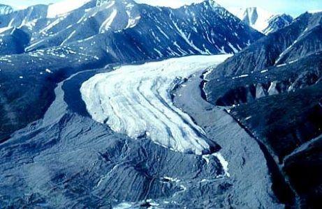
Transcription
1 Chapter 17 Glacial & Periglacial Landscapes
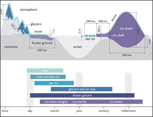
2 Cryosphere Cryosphere - the portions of Earth's surface where water is in solid form, including sea ice, lake ice, river ice, snow cover, glaciers, ice caps, ice sheets, and frozen ground (which includes permafrost). Generally found at high latitudes and at high elevations
3
4 Snowline The climatic snowline is the point above which snow and ice cover the ground throughout the year. Glaciers form by the continual accumulation of snow that recrystallizes under its own weight into an ice mass. Through the summer, rain and snowmelt seeps down into the snowfield and refreezes. Air spaces are compressed as the snow packs to a greater density When snow falls to Earth, it will either melt or accumulate.

5 Firn Firn - a type of snow that has been left over from past seasons and has been recrystallized It is ice that is at an intermediate stage between snow and glacial ice. Firn has the appearance of wet sugar, but has a hardness that makes it extremely resistant to shovelling. It can often be found underneath the snow that accumulates at the head of a glacier.

6 Glacial Ice Glacial ice - dense ice produced over a period of many years up to 1,000 years in Antarctica due to the dryness of the climate Glacial ice is the largest reservoir of fresh water on Earth. Many glaciers from temperate, alpine and seasonal polar climates store water as ice during the colder seasons and release it later in the form of meltwater as warmer summer temperatures cause the glacier to melt, creating a water source that is especially important for plants, animals and human uses when other sources may be scant. Within high-altitude and Antarctic environments, the seasonal temperature difference is often not sufficient to release meltwater. A large piece of compressed ice, or a glacier, appears blue, as large quantities of water appear blue. This is because water molecules absorb other colors more efficiently than blue. The other reason for the blue color of glaciers is the lack of air bubbles. Air bubbles, which give a white color to ice, are squeezed out by pressure increasing the density of the created ice.


7 Glacier Glacier - a persistent body of dense ice that is constantly moving under its own weight over many centuries. Rests on land or floats in the sea attached to a landmass as an ice shelf. Glacial ice behaves in a plastic, or pliable, manner - it slowly deforms and flows due to stresses induced by their own weight and gravity. As a valley glacier flows slowly downhill it erodes the mountains, canyons, and river valleys beneath its mass, transporting material within or along its base. A portion of the transported debris may also be carried on its icy surface, visible as dark streaks and bands. Glaciers move in streamlike patterns, merging as tributaries into large rivers of ice that slowly flow outward toward the ocean Fig a
8 Glacier Categories Two general groups based on their form, size, and flow characteristics: Alpine glaciers - form in mountain ranges Continental ice sheets - extensive ice sheets that cover large landmasses

9 Cirque Cirque - a bowl-shaped depression carved out of a mountain by an alpine glacier. Usually the accumulation area for head of a glacial mass. Many cirque glaciers may jointly feed a valley glacier. A piedmont glacier forms wherever several valley glaciers pour out of their confining valleys and coalesce at the base of a mountain range.

10 Calving Ice calving - the breaking of ice chunks from the edge of a glacier. The ice that breaks away can be classified as an iceberg, growler, or bergy bit. Occurs wherever a glacier meets and ocean, bay, or fjord. Calving of glaciers is often accompanied by a loud cracking or booming sound before blocks of ice up to 60 metres (200 ft) high break loose and crash into the water. The entry of the ice into the water causes large, and often hazardous waves.

11 Continental Ice Sheet Ice sheet - a mass of glacier ice that covers surrounding terrain and is greater than 50,000 km2 (19,000 sq mi), this is also known as continental glacier. The only current ice sheets are in Antarctica and Greenland Ice sheets cover 90% of Antarctica and 81% of Greenland These ice sheets have such enormous mass that large portions of each landmass beneath the ice are isostatically depressed pressed down by weight - below sea level Each ice sheet reaches thicknesses of more than 3000 m (9800 ft) with average thicnkess around 2000 m ( 6500 ft), buying all but the highest peaks of the land. At the edge of ice sheets are ice shelves, permanent masses off ice that extend out over the sea - these shelves reach thicknesses of 1000 m (3280 ft)
12 Ice Cap/Ice Field Ice cap - an ice mass that is roughly circular and covers less than 50,000 km² of land area (usually lies over the top of a mountain) Fig Ice field - least extensive form of a glacier, with mountain ridges and peaks visible above the ice Fig. 17.5
13 Glacial Balance Glaciers acquire snow in their accumulation zone, a snowfield at the highest level of an ice sheet or ice cap or at the head of a valley glacier - a cirque. Ablation - the opposite of accumulation refers to all processes that remove snow, ice, or water from a glacier or snowfield. pp GIA Ablation refers to the melting of snow or ice that runs off the glacier, evaporation, sublimation, calving, or erosive removal of snow by wind.
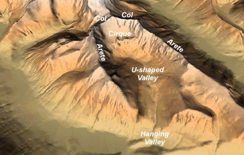
14 Glacial Movement Glaciers are only rigid on the surface. Below this layer is a plastic zone that moves forward. The base layer grinds and slides along with varying speed due to temperature and presence of lubricating water beneath the ice. Compression of the ice from an uneven surface will cause it to melt, and later it will refreeze. Fig. 17.6

15 Crevasse Crevasse - a deep, vertical crack, or fracture, found on the surface of an ice sheet or glacier. form as a result from friction with valley walls, and due to stretching and compression
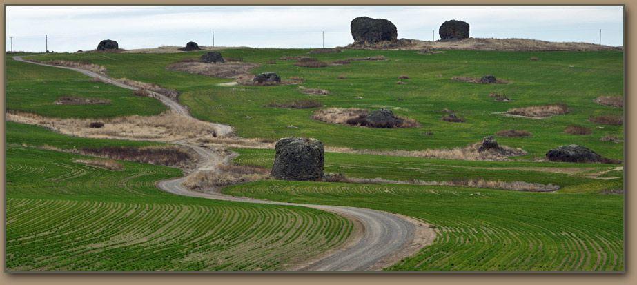
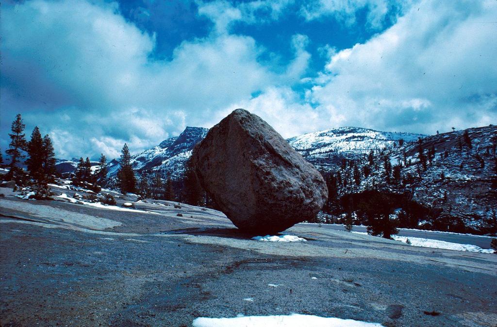
16 Glacial Erosion Glaciers mechanically pick up rock material and carry it away in a process known as glacial plucking. Debris is also carried on its surface and transported internally. As a glacier retreats, it can leave cobbles and boulders that are foreign in composition and origin to the ground on which they are deposited called glacial erratics.

17
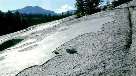
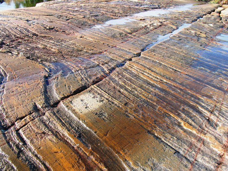
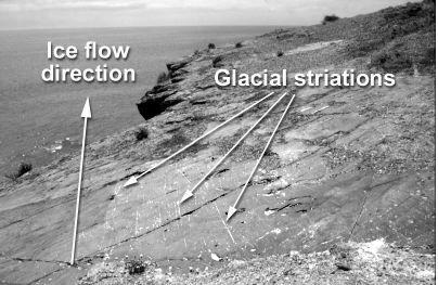
18 Abrasion Rocks pieces frozen to the basal layers of the glacier enable the ice mass to scour the landscape like sandpaper. Glacial abrasion produces a smooth surface on exposed rock, which shines with glacial polish when the glacier retreats. Larger rocks in the glacier act like chisels, gouging the underlying surface and producing glacial striations parallel to the flow direction.
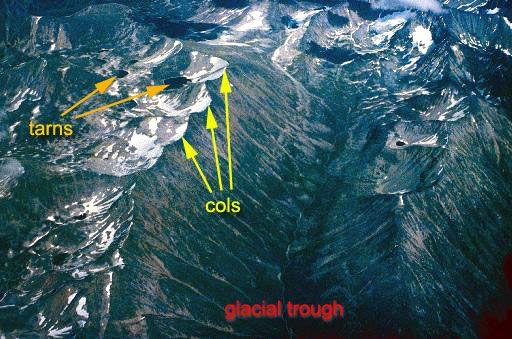
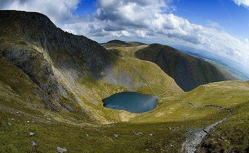
19


20 Glacial Erosional Landforms Rôche moutonnée - an asymmetrical hill of exposed bedrock. has a characteristic gently sloping upstream side (stoss side) that is polished smooth by glacial action and an abrupt and steep downstream side (lee side) where the glacier plucked rock pieces.
21 Arête/Col An arête is a narrow ridge of rock which separates two valleys. It is typically formed when two glaciers erode parallel U-shaped valleys. Two eroding cirques may reduce an arêtes to a saddle-shaped pass, or col. Where three or more cirques meet, a pyramidal peak is created.

22

23 Horn A horn, or pyramidal peak, is an angular, sharply pointed mountain peak which results when several cirque glaciers gouge an individual mountain summit from all sides.

24 The Matterhorn, a classic example of a pyramidal peak.


25 Bergschrund A bergschrund is a crevasse that forms where moving glacier ice separates from the stagnant ice or firn above. It is often a serious obstacle for mountaineers.

26 Tarn A tarn is a mountain lake or pool, formed in a cirque excavated by a glacier. It is formed when either rain or river water fills the cirque.
27


28 U-shaped Valleys U-shaped valleys result from glacial erosion. V-shaped valleys are stream-cut.

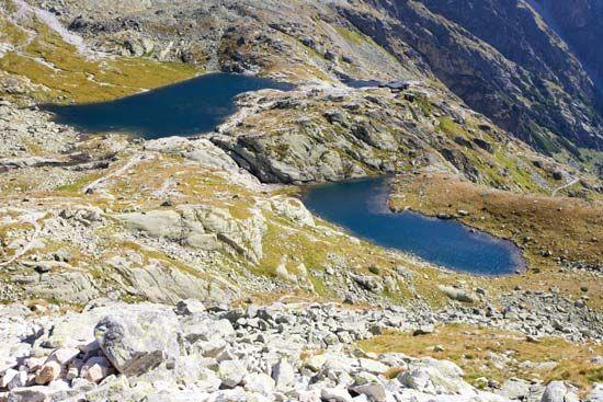
29 Paternoster Lake Paternoster lakes small, stair-stepped lakes. Formed from differing resistance of rock to glacial processes or from damming by glacial deposits.

30 Fjord Where a glacial trough meets the ocean, the glacier can continue to erode the landscape, even below sea level. Fjord is a deep, long, narrow inlet with steep sides or cliffs, created by glacial erosion. Fig
31 Glacial Deposits Glaciers transport materials on and inside the ice, producing unsorted sediment deposits. The actions of meltwater streams under the glacier and at the glacier s downstream end, produce sorted deposits. Glacial drift - general term for all glacial deposits Till - the unsorted and unstratified debris deposited on the ground by a glacier as it melts usually marks the glacier s former margins

32
33 Moraine A moraine is any glacially formed accumulation of unconsolidated glacial debris (regolith and rock). Lateral Moraines are formed at the side of the ice flow Medial Moraines are formed where two glaciers meet. Terminal Moraines are formed at the foot of the ice flow, marking the maximum advance of the glacier.

34

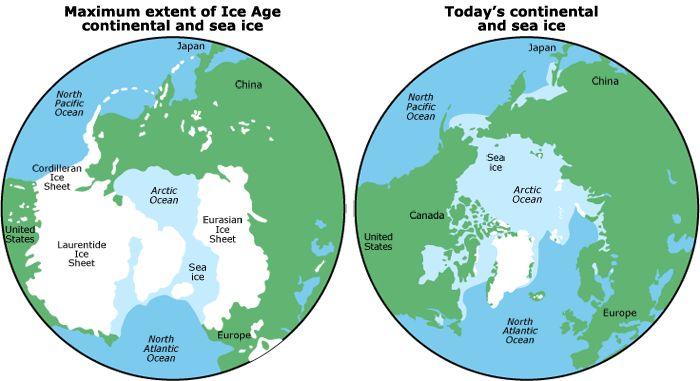
35 Till Plain A till plain is an extensive flat plain of glacial till that forms when a sheet of ice becomes detached from the main body of a glacier and melts in place, depositing the sediments it carried.

36 Esker An esker is a long, winding ridge of stratified sand and gravel which formed in a glacial tunnel. Examples of which occur in glaciated and formerly glaciated regions of Europe and North America.


37 Kettle A kettle (kettle hole, pothole) is a shallow, sediment-filled body of water formed by retreating glaciers or draining floodwaters. The kettles are formed as a result of blocks of ice calving from glaciers and becoming submerged in the sediment on the outwash plain.
38 Periglacial Periglacial describes geomorphic processes that result from seasonal thawing of snow in areas of permafrost, the runoff from which refreezes in ice wedges and other structures. "Periglacial" suggests an environment located on the margin of past glaciers. Therefore, periglacial environments are anywhere that freezing and thawing modify the landscape in a significant manner. Tundra is a common ecological community in periglacial areas.

39 Active Layer In environments containing permafrost, the active layer is the top layer of soil that thaws during the summer and freezes again during the autumn. The frozen subsurface is called ground ice. The amount of ground ice present varies with moisture content, ranging from only a small percentage in drier regions to almost 100% with saturated soils. When cracks develop in the active layer, water can seep in, or well up. If it freezes, it will widen the cracks.

40 Patterned Ground Patterned Ground is the distinct, and often symmetrical natural pattern of geometric shapes formed by ground material in periglacial regions. The expansion and contraction of soils due to freezing and thawing, or frost action, results in the movement of soil particles, stones, and small boulders into distinct shapes.
41 Humans & Paraglacial Lanscapes Structural collapse Fig Trans-Alaskan oil pipeline Fig

42 Ice Age An ice age is a period of long-term reduction in the temperature of Earth's surface and atmosphere, resulting in the presence or expansion of continental and polar ice sheets and alpine glaciers.
43
, larger than the Caspian")
44 Paleolake An ancient lake (especially one that no longer exists) Fig Fig Lake Chad is the remnant of a former inland sea, palaeolake Mega-Chad. At its largest, sometime before 5,000 BC, Lake Mega-Chad was the largest of four Saharan palaeolakes and is estimated to have covered an area of 400,000 km2 (150,000 sq mi), larger than the Caspian Sea is today. This total map of the total African continent shows the massive size of both lakes, in comparison to both existing Great Lakes of Africa (Lake Victoria, Lake Malawi, etc.) and to the size of the continet as a whole. The map also shows ths distinct difference between the two lakes. Lake Congo is a tropical lake while the southern half of Lake Chad lies in the Sahel, and it's northern half in the Sahara. Read more: s#ixzz4mgzdypcr

45 Arctic Region Land within the Arctic region has seasonally varying snow and ice cover, with predominantly treeless permafrost-containing tundra. Arctic seas contain seasonal sea ice in many places.
46 Antarctic Region The region around the Earth's South Pole, opposite the Arctic region around the North Pole. The Antarctic comprises in the strict sense the continent of Antarctica and the island territories located on the Antarctic Plate. In a broader sense the Antarctic region include the ice shelves, waters, and island territories in the Southern Ocean situated south of the Antarctic Convergence, a zone approximately 32 to 48 km (20 to 30 mi) wide varying in latitude seasonally. Fig

47
1 Glacial Erosion and
 www.ck12.org Chapter 1. Glacial Erosion and Deposition CHAPTER 1 Glacial Erosion and Deposition Lesson Objectives Discuss the different erosional features formed by alpine glaciers. Describe the processes
Recrystallization of snow to form LARGE. called FIRN: like packed snowballs. the weight of overlying firn and snow.
 Chapter 11 Glaciers BFRB P. 103-104, 104, 108, 117-120120 Process of Glacier Formation Snow does NOT melt in summer Recrystallization of snow to form LARGE crystals of ice (rough and granular) called
Glaciers and Glaciation Earth - Chapter 18 Stan Hatfield Southwestern Illinois College
 Glaciers and Glaciation Earth - Chapter 18 Stan Hatfield Southwestern Illinois College Glaciers Glaciers are parts of two basic cycles: 1. Hydrologic cycle 2. Rock cycle A glacier is a thick mass of ice
glacier Little Ice Age continental glacier valley glacier ice cap glaciation firn glacial ice plastic flow basal slip Chapter 14
 Little Ice Age glacier valley glacier continental glacier ice cap glaciation firn glacial ice plastic flow basal slip glacial budget zone of accumulation zone of wastage glacial surge abrasion glacial
Glaciers. Glacier Dynamics. Glacier Dynamics. Glaciers and Glaciation. Types of Glaciers. Chapter 15
 Chapter 15 Glaciers and Glaciation Glaciers A glacier is a large, permanent (nonseasonal) mass of ice that is formed on land and moves under the force of gravity. Glaciers may form anywhere that snow accumulation
READING QUESTIONS: Chapter 7, Glaciers GEOL 131 Fall pts. a. Alpine Ice from larger ice masses flowing through a valley to the ocean
 READING QUESTIONS: Chapter 7, Glaciers GEOL 131 Fall 2018 63 pts NAME DUE: Tuesday, October 23 Glaciers: A Part of Two Basic Cycles (p. 192-195) 1. Match each type of glacier to its description: (2 pts)
Glaciers Earth 9th Edition Chapter 18 Mass wasting: summary in haiku form Glaciers Glaciers Glaciers Glaciers Formation of glacial ice
 1 2 3 4 5 6 7 8 9 10 11 12 13 14 15 Earth 9 th Edition Chapter 18 Mass wasting: summary in haiku form Ten thousand years thence big glaciers began to melt - called "global warming." are parts of two basic
I. Types of Glaciers 11/22/2011. I. Types of Glaciers. Glaciers and Glaciation. Chapter 11 Temp. B. Types of glaciers
 Why should I care about glaciers? Look closely at this graph to understand why we should care? and Glaciation Chapter 11 Temp I. Types of A. Glacier a thick mass of ice that originates on land from the
Chapter 16 Glaciers and Glaciations
 Chapter 16 Glaciers and Glaciations Name: Page 419-454 (2nd Ed.) ; Page 406-439 (1st Ed.) Part A: Anticipation Guide: Please read through these statements before reading and mark them as true or false.
PHYSICAL GEOGRAPHY GEOGRAPHY EARTH SYSTEMS COASTAL SYSTEMS FLUVIAL SYSTEMS
 PHYSICAL GEOGRAPHY EARTH SYSTEMS FLUVIAL SYSTEMS COASTAL SYSTEMS PHYSICAL GEOGRAPHY CORRIES / CIRQUES A Corrie or Cirque is the armchair shaped hollow that was the birthplace of a glacier. It has steep,
The Physical Geography of Long Island
 The Physical Geography of Long Island A Bit About Long Island Length 118 miles Brooklyn to Montauk Geo202 Spring 2012 Width 23 miles at it s widest Area 1,400 square miles Formation of Long Island River
READING QUESTIONS: Glaciers GEOL /WI 60 pts. a. Alpine Ice from larger ice masses flowing through a valley to the ocean
 READING QUESTIONS: Glaciers GEOL 131 18/WI 60 pts NAME DUE: Tuesday, March 13 Glaciers: A Part of Two Basic Cycles (p. 192-195) 1. Match each type of glacier to its description: (2 pts) a. Alpine Ice from
Glaciers. Glacier Dynamics. Glaciers and Glaciation. East Greenland. Types of Glaciers. Chapter 16
 Chapter 16 Glaciers A glacier is a large, permanent (nonseasonal) mass of ice that is formed on land and moves under the force of gravity. Glaciers may form anywhere that snow accumulation exceeds seasonal
Chapter 14. Glaciers and Glaciation
 Chapter 14 Glaciers and Glaciation Introduction Pleistocene Glaciations: A series of "ice ages" and warmer intervals that occurred 2.6 million to 10,000 years ago. The Little Ice Age was a time of colder
Glaciers. Clicker Question. Glaciers and Glaciation. How familiar are you with glaciers? West Greenland. Types of Glaciers.
 Chapter 21 Glaciers A glacier is a large, permanent (nonseasonal) mass of ice that is formed on land and moves under the force of gravity. Glaciers may form anywhere that snow accumulation exceeds seasonal
Glaciers and Glaciation
 Chapter 18 Lecture Earth: An Introduction to Physical Geology Eleventh Edition Glaciers and Glaciation Tarbuck and Lutgens Glaciers: A Part of Two Basic Cycles A glacier is a thick mass of ice that forms,
Glaciers. Valley or Alpine glaciers. Ice sheets. Piedmont - foot of the mountain glaciers. Form in mountainous areas Move downslope in valleys
 Glaciers & Ice Ages Glaciers Valley or Alpine glaciers Form in mountainous areas Move downslope in valleys Ice sheets Move outward from center Continental glaciers - large scale, ice age type. Presently
ENVI2030L - ALPINE AND CONTINENTAL GLACIATION
 NAME ENVI2030L - ALPINE AND CONTINENTAL GLACIATION I. Introduction Glaciers are slowly moving ice sheets. They are very effective erosional agents and can drastically modify the landscapes over which they
Glaciers. Chapter 17
 Glaciers Chapter 17 Vocabulary 1. Glacier 2. Snowfield 3. Firn 4. Alpine glacier 5. Continental glacier 6. Basal slip 7. Internal plastic flow 8. Crevasses 9. Glacial grooves 10. Ice shelves 11. Icebergs
Shaping of North America. Physical Geography II of the United States and Canada. The Last Ice Age. The Ice Age. Pleistocene Polar Ice Cap 2/14/2013
 Physical Geography II of the United States and Canada Prof. Anthony Grande AFG 2012 Shaping of North America The chief shaper of the landscape of North America is and has been running water. Glaciation
Glaciers Earth Chapter 18 Chapter 18 Glaciers & Glaciation Glaciers: A Part of Two Basic Cycles Glaciers: A Part of Two Basic Cycles Valley Glacier
 1 2 3 4 5 6 7 8 9 10 11 12 Glaciers Earth Chapter 18 Chapter 18 Glaciers & Glaciation A glacier is a thick mass of ice that forms, over hundreds and thousands of years, by the accumulation, compaction,
Glaciers. Reading Practice
 Reading Practice A Glaciers Besides the earth s oceans, glacier ice is the largest source of water on earth. A glacier is a massive stream or sheet of ice that moves underneath itself under the influence
Q: What is a period of time whereby the average global temperature has decreased? Q: What is a glacier?
 Q: What is a glacier? A: A large sheet of ice which lasts all year round. Q: What is a period of time whereby the average global temperature has decreased? A: A glacial. Q: What is an interglacial? Q:
1.4 Understand how moving ice acts as an agent of erosion and deposition. (Chap. 2)
") 1.4 Understand how moving ice acts as an agent of erosion and deposition. (Chap. 2) There are two types of glaciation. Alpine Glaciation Continental Glaciation Distinguish between the terms alpine glaciation
1.4 Understand how moving ice acts as an agent of erosion and deposition. (Chap. 2) There are two types of glaciation. Alpine Glaciation Continental Glaciation Distinguish between the terms alpine glaciation
Dynamic Planet: Glaciers
 Team Name+Number Teammate 1 name Teammate 2 name Dynamic Planet: Glaciers (by Shad160) The following test is 80 questions long, split up into four different sections. The first 20 questions are worth 40
GLACIATION. The Last Ice Age (see Chapter 12) and. Pleistocene Ice Cap. Glacial Dynamics 10/2/2012. Laurentide Ice Sheet over NYS
 and. Pleistocene Ice Cap. Glacial Dynamics 10/2/2012. Laurentide Ice Sheet over NYS") GLACIATION and New York State Prof. Anthony Grande The Last Ice Age (see Chapter 1) The Pleistocene Epoch began 1.6 mya. During this time, climates grew colder. There were numerous ice ages starting 100,000000
GLACIATION and New York State Prof. Anthony Grande The Last Ice Age (see Chapter 1) The Pleistocene Epoch began 1.6 mya. During this time, climates grew colder. There were numerous ice ages starting 100,000000
Dynamic Planet Practice Test Written by Samuel Bressler
 Dynamic Planet Practice Test 2013 Written by Samuel Bressler Part 1: Multiple Choice 1. Which of the following is NOT related to alpine glaciation? a) Serac b) Kame c) Col d) Paternoster Lake 2. The common
Geography 120, Instructor: Chaddock In Class 13: Glaciers and Icecaps Name: Fill in the correct terms for these descriptions: Ablation zone: n zne:
 Geography 120, Instructor: Chaddock In Class 13: Glaciers and Icecaps Name: Fill in the correct terms for these descriptions: Ablation zone: The area of a glacier where mass is lost through melting or
Mighty Glaciers. Mighty Glaciers. Visit for thousands of books and materials.
 Mighty Glaciers A Reading A Z Level M Leveled Reader Word Count: 684 LEVELED READER M Mighty Glaciers Written by Ned Jensen Visit www.readinga-z.com for thousands of books and materials. www.readinga-z.com
Glaciers and Periglaciers
 Glaciers and Periglaciers Chapter 9, page 132 Glaciation!1836 Louis Agassiz theorized that parts of Europe and North America were covered by huge ice sheets.!known as the Pleistocene Ice Ages Why do we
Gifts of the Glaciers
 Gifts of the Glaciers Gifts of the Glaciers Moving ice of glacier was responsible for water, landforms, and soil characteristics and patterns of today Sculpturing of bedrock materials Glacial Landforms
GEOMORPHOLOGY EXAM #3
 Formation of Glaciers GEOMORPHOLOGY EXAM #3 - Transformation of snow into glacial ice - Density; SNOW = 0.07 0.18 g/cc FIRN(Neve) = 0.4 0.8 g/cc (Pellets) GLACIAL ICE = 0.8 0.9 g/cc - Firn / Ice Boundary
Name Team Number. 1. The famous question: What percent of Earth's surface is covered by glaciers? A) 5% D) neve
 5% D) neve") Part I: Multiple Choice (30pts) Directions: Please choose the best answer for each question. There is only one correct answer for each question unless otherwise stated. There are 30 questions. Each one
Part I: Multiple Choice (30pts) Directions: Please choose the best answer for each question. There is only one correct answer for each question unless otherwise stated. There are 30 questions. Each one
Parts of a Glacier Division A Study Guide- Part 2
 Parts of a Glacier Division A Study Guide- Part 2 Zones of a glacier Zone of Accumulation: The region where snowfall adds ice to the glacier. It occurs where the temperature remains cold enough year-round
glacial drift: all deposits associated with glaciation; covers 8% of Earth s surface above sealevel, and 25% of North America
 Glacial depositional features glacial drift: all deposits associated with glaciation; covers 8% of Earth s surface above sealevel, and 25% of North America i) nonstratified drift till: transported & deposited
Dynamic Planet C Test
 Northern Regional: January 19 th, 2019 Dynamic Planet C Test Name(s): Team Name: School Name: Team Number: Rank: Score: Dynamic Planet B/C Glaciers (87 total points) Multiple choice/fill in the blank (23
Great Science Adventures
 Great Science Adventures Lesson 18 How do glaciers affect the land? Lithosphere Concepts: There are two kinds of glaciers: valley glaciers which form in high mountain valleys, and continental glaciers
Teacher s Guide For. Glaciers
 Teacher s Guide For Glaciers For grade 7 - College Program produced by Centre Communications, Inc. for Ambrose Video Publishing, Inc. Executive Producer William V. Ambrose Teacher's Guide by Mark Reeder
E arth s climate strongly influences
 Section 7.1 7.1 Glaciers 1 FOCUS Section Objectives 7.1 Describe the different types of glaciers and where each type is found. 7.2 Explain how glaciers move and describe the different types of glacial
THE DEPARTMENT OF HIGHER EDUCATION UNIVERSITY OF COMPUTER STUDIES FIFTH YEAR
 THE DEPARTMENT OF HIGHER EDUCATION UNIVERSITY OF COMPUTER STUDIES FIFTH YEAR (B.C.Sc./B.C.Tech.) RE- EXAMINATION SEPTEMBER 2018 Answer all questions. ENGLISH Time allowed: 3 hours QUESTION I Glaciers A
LAB P - GLACIAL PROCESSES AND LANDSCAPES
 Introduction LAB P - GLACIAL PROCESSES AND LANDSCAPES Ice has been a significant force in modifying the surface of the earth at numerous times throughout Earth s history. Though more important during the
USGS/Austin Post. (b)
") TYPES OF GLACIERS 525 NASA/GSFC/MITI/ERSDAC/JAROS, and U.S./Japan ASTER Science Team (a) USGS/Austin Post (b) FIGURE 19.2 Glaciers that flow into the sea or a deep lake undergo calving, the process by
TYPES OF GLACIERS 525 NASA/GSFC/MITI/ERSDAC/JAROS, and U.S./Japan ASTER Science Team (a) USGS/Austin Post (b) FIGURE 19.2 Glaciers that flow into the sea or a deep lake undergo calving, the process by
Did It. naturalists. Young. Moving and melting ice shaped many of Minnesota s land features. 30 Minnesota Conservation Volunteer
 Young naturalists by Mary Hoff Photography by Gary Alan Nelson T he Glacier Did It Moving and melting ice shaped many of Minnesota s land features. Shut your eyes. Imagine that it s a sunny summer day
Mearns Castle High School. Geography Department. Glaciated Landscapes
 Mearns Castle High School Geography Department Glaciated Landscapes Lesson One: Location of Glaciated Uplands in the British Isles The Ice Age in Britain began about 1,000,000 years ago and lasted until
Chapter 7 Snow and ice
 Chapter 7 Snow and ice Throughout the solar system there are different types of large ice bodies, not only water ice but also ice made up of ammonia, carbon dioxide and other substances that are gases
Red Tarn, Lake District They are all features of glacial erosion
 Ribbon Lake Lake Windermere, Lake District Arete Striding Edge, Lake District 1 2 3 Pyramidal Peak Corrie & Tarn 4 Matterhorn, Switzerland Red Tarn, Lake District They are all features of glacial erosion
Geologic Trips, Sierra Nevada
 ISBN 0-9661316-5-7 GeoPress Excerpt from Geologic Trips, Sierra Nevada by Ted Konigsmark All rights reserved. No part of this book may be reproduced without written permission, except for critical articles
Glacial Geomorphology Exercise
 James Madison University Field Course in western Ireland Glacial Geomorphology Exercise 3-day road log (abbreviated) Striations Large kame terrace Cirque with moraines Kame delta Striations Eskers Raised
What is a Glacier? GLACIOLOGY vs. GLACIAL GEOLOGY. snow corn firn glacier snow = neve ice
 What is a Glacier? Mass of Ice Derived from Snow Lasts from Year to Year Moves Due to Its Own Weight GLACIOLOGY vs. GLACIAL GEOLOGY Transformation of Snow to Glacial Ice snow corn firn glacier snow = neve
Lesson. Glaciers Carve the Land A QUICK LOOK. Overview. Big Idea. Process Skills Key Notes
 EARTH S CHANGING SURFACE CLUSTER 2 HOW THE EARTH S SURFACE CHANGES Lesson 62 Glaciers Carve the Land A QUICK LOOK Big Idea Moving water, ice, and wind break down rock, transport materials, and build up
What would you say was the extend of the ice cover? 100%? 50%? A third? 2/3?
 This map shows the maximum extent of ice cover during the last ice age, 20,000 years ago. What would you say was the extend of the ice cover? 100%? 50%? A third? 2/3? KEY IDEAS & QUESTIONS What is a glacier?
2. (1pt) From an aircraft, how can you tell the difference between a snowfield and a snow-covered glacier?
 From an aircraft, how can you tell the difference between a snowfield and a snow-covered glacier?") 1 GLACIERS 1. (2pts) Define a glacier: 2. (1pt) From an aircraft, how can you tell the difference between a snowfield and a snow-covered glacier? 3. (2pts) What is the relative size of Antarctica, Greenland,
1 GLACIERS 1. (2pts) Define a glacier: 2. (1pt) From an aircraft, how can you tell the difference between a snowfield and a snow-covered glacier? 3. (2pts) What is the relative size of Antarctica, Greenland,
Unit 1: Physical Environment Glaciated Landscapes
 Unit 1: Physical Environment Glaciated Landscapes Corries Corries are bowl-shaped hollows high up in the mountains. They are formed in the following way: Snow collects in a hollow on a mountainside (usually
Please make sure that all teachers and chaperones attending the field study are aware of the following information:
 Dear Teacher, Thank you for signing up for The Ice Age at the Lost Valley Visitor Center in Glacial Park. The visitor center is located in the middle of Glacial Park. Follow the signs from the Harts Road
glacier 1 of 9 For the complete encyclopedic entry with media resources, visit:
 This website would like to remind you: Your browser (Apple Safari 4) is out of date. Update your browser for more security, comfort and the best experience on this site. Encyclopedic Entry glacier For
Formation of a Corrie
 Formation of a Corrie A corrie looks rather like a armchair has been cut out of the rock face When a hill has been heavily eroded with 3 or 4 corries the jagged hill that is left is known as a pyramidal
How Glaciers Change the World By ReadWorks
 How Glaciers Change the World How Glaciers Change the World By ReadWorks Glaciers are large masses of ice that can be found in either the oceans or on land. These large bodies of frozen water have big
BLASTING GLACIAL ICE AND SNOW ABSTRACT
 BLASTING GLACIAL ICE AND SNOW HERB BLEUER ABSTRACT This presentation, with the aid of slides, is about methods of blasting large quantities of glacial ice and snow. The project illustrated here involved
What is a Glacier? GLACIOLOGY vs. GLACIAL GEOLOGY. snow corn firn glacier snow = neve ice
 What is a Glacier? Mass of Ice Derived from Snow Lasts from Year to Year Moves Due to Its Own Weight GLACIOLOGY vs. GLACIAL GEOLOGY Transformation of Snow to Glacial Ice snow corn firn glacier snow = neve
Alpine Glacial Features along the Chimney Pond Trail, Baxter State Park, Maine
 Maine Geologic Facts and Localities September, 2009 Alpine Glacial Features along the Chimney Pond Trail, Baxter State Park, Maine 45 54 57.98 N, 68 54 41.48 W Text by Robert A. Johnston, Department of
Glacial Origins and Features of Long Island
 Glacial Origins and Features of Long Island Interior Coastal Plain Continental Shelf Long Island s Geology 0 Ma Phanerozoic 540 Ma Proterozoic 2500 Ma Archean 3800 Ma Hadean 4600 Ma C M P Geologic Time
Your web browser (Safari 7) is out of date. For more security, comfort and the best experience on this site: Update your browser Ignore
 is out of date. For more security, comfort and the best experience on this site: Update your browser Ignore") Your web browser (Safari 7) is out of date. For more security, comfort and the best experience on this site: Update your browser Ignore GL ACIER For the complete encyclopedic entry with media resources,
Your web browser (Safari 7) is out of date. For more security, comfort and the best experience on this site: Update your browser Ignore GL ACIER For the complete encyclopedic entry with media resources,
MIDDLE SCHOOL CURRICULUM TR AILING ICE AGE M YST ERI E S SEARCHING GLACIAL FEATURES
 MIDDLE SCHOOL CURRICULUM TR AILING ICE AGE M YST ERI E S SEARCHING GLACIAL FEATURES CONTENTS I. Enduring Knowledge... 3 II. Teacher Background... 3 III. Before Viewing the Video... 5 IV. Viewing Guide...
THE INFLUENCE OF DEBRIS ON THE FLOW OF GLACIERS.
 THE INFLUENCE OF DEBRIS ON THE FLOW OF GLACIERS. THE behavior of ice under various conditions is frequently illustrated by experiments with pitch or other similar viscous fluids or plastic solids. If sand
Landscapes in the UK: Glaciation 1. Extent of ice cover across the UK during the last ice age.
 Landscapes in the UK: Glaciation 1. Extent of ice cover across the UK during the last ice age. Key idea: Ice was a powerful force in shaping the landscape of the UK. In the past the climate has got colder
GLACIER STUDIES OF THE McCALL GLACIER, ALASKA
 GLACIER STUDIES OF THE McCALL GLACIER, ALASKA T John E. Sater* HE McCall Glacier is a long thin body of ice shaped roughly like a crescent. Its overall length is approximately 8 km. and its average width
APPENDIX E GLACIERS AND POLAR ICE CAPS
 APPENDIX E GLACIERS AND POLAR ICE CAPS GLACIERS The dictionary defines a glacier as a large mass of ice and snow that forms in areas where the rate of snowfall constantly exceeds the rate at which the
Changing Landscapes: Glaciated Landscapes. What are glaciers?
 Changing Landscapes: Glaciated Landscapes What are glaciers? What you need to know Types of ice mass at a range of scales including cirque glaciers, valley glaciers, highland ice field, piedmont glaciers,
Glacier facts and information about Nigardsbreen
 Glacier facts and information about Nigardsbreen Fact sheet for Jostedalen Breførarlag made by Marthe Gjerde 1/1/2014 University of Bergen Marthe Gjerde J.C. Dahl Time WHAT IS A GLACIER? A glacier is a
Landscapes in the UK: Glaciation 1. Extent of ice cover across the UK during the last ice age.
 Landscapes in the UK: Glaciation 1. Extent of ice cover across the UK during the last ice age. Key idea: Ice was a powerful force in shaping the landscape of the UK. As the climate has changed in the past,
AGAP Antarctic Research Project Visualizing Data Learning About Antarctica From RADAR Data? Student Version
 AGAP Antarctic Research Project Visualizing Data Learning About Antarctica From RADAR Data? Student Version Name Date Image of Subglacial Lake network courtesy of NSF Ice Sheet: A large glacier that covers
NYS Invitational Science Olympiad April 2005 DYNAMIC PLANET: GLACIERS
 NYS Invitational Science Olympiad April 2005 School Team # DYNAMIC PLANET: GLACIERS 1. What type of glacier is shown in the photo? 2. a. What is the name of the feature labeled A? b. How did feature A
GC 225 Lecture Exam #2
 GC 225 Lecture Exam #2 Direction- path along which something is moving. 3 Types; - COMPASS DIRECTIONAL NAME (32 in total) - BEARING (four 0 o - 90 o ) - AZIMUTHS (0 o - 360 o ) Compass (32 named points)
Glaciers are thrilling. Glaciers are Melting McBride Glacier, Glacier Bay. Melting glaciers reveal the effects of glaciation. Why Glaciers?
 Glaciers are thrilling Six trips to SE Alaska, most recent 2015 Additional trips up Inside Passage Author of Glaciers, Bears and Totems Glaciers are Melting McBride Glacier, Glacier Bay 2011 2015 Why Glaciers?
Comparison Pictures of Receding Glaciers
 Comparison Pictures of Receding Glaciers In the photo above, the west shoreline of Muir Inlet in Alaska's Glacier Bay National Park & Preserve is shown as it appeared in 1895. Notice the lack of vegetation
Rationale or Purpose: This lesson will demonstrate several properties of water and bring awareness of what global warming may do to the sea level.
 Title: Glaciers and Icebergs Grade Level: 5th Objectives: Students will be able to: Identify the differences and similarities between a glacier and an iceberg; Recall the density of water and ice; Observe
Geoscape Toronto The Oak Ridges Moraine Activity 2 - Page 1 of 10 Information Bulletin
 About 13,000 years ago as the Laurentide Ice Sheet melted, glacial meltwater accumulated between the ice sheet and the Niagara Escarpment. This formed a lake basin into which gravel and sand were deposited.
Making glacial connections
 Student task A 1. Cut and arrange the cards below to make four sets of four connections: Four connections Matterhorn drumlin lateral U-shaped valley outwash plain truncated spur Lauterbrunnen ground medial
MIDDLE SCHOOL CURRICULUM TR AILING ICE AGE M YST ERI E S ICE AGE TREKKING
 MIDDLE SCHOOL CURRICULUM TR AILING ICE AGE M YST ERI E S ICE AGE TREKKING CONTENTS I. Enduring Knowledge... 3 II. Teacher Background... 3 III. Before Viewing this Video... 5 IV. Viewing Guide... 5 V. Discussion
Lesson 5: Ice in Action
 Everest Education Expedition Curriculum Lesson 5: Ice in Action Created by Montana State University Extended University and Montana NSF EPSCoR http://www.montana.edu/everest Lesson Overview: Explore glaciers
Exam Review. Part 3- Deserts, Glaciers, and maps
 Exam Review Part 3- Deserts, Glaciers, and maps What causes a desert? Lots of sand Vegetation holds the arms Star Dunes- Star dunes form only in places where wind blows from varied directions over the
For Creative Minds. Glaciers
 For Creative Minds The For Creative Minds educational section may be photocopied or printed from our website by the owner of this book for educational, non-commercial uses. Cross-curricular teaching activities,
Introduction to Safety on Glaciers in Svalbard
 Introduction to Safety on Glaciers in Svalbard Content Basic info on Svalbard glaciers Risk aspects when travelling on glaciers Safe travel on glaciers UNIS safety & rescue equipment Companion rescue in
Just how big is Africa?
 The United States China India The United Kingdom Portugal Spain France Belgium Germany The Netherlands Switzerland Italy Eastern Europe Japan 11.7 million sq. miles Just how big is Africa? Chapter 18 Section
The Potentially Dangerous Glacial Lakes
 Chapter 11 The Potentially Dangerous Glacial Lakes On the basis of actively retreating glaciers and other criteria, the potentially dangerous glacial lakes were identified using the spatial and attribute
Exam Review. Part 3- Deserts, Glaciers, and maps
 Exam Review Part 3- Deserts, Glaciers, and maps What causes a desert? Lots of sand Vegetation holds the arms Star Dunes- Star dunes form only in places where wind blows from varied directions over the
ESS Glaciers and Global Change
 ESS 203 - Glaciers and Global Change Friday January 5, 2018 Outline for today Please turn in writing assignment and questionnaires. (Folders going around) Questions about class outline and objectives?
Geomorphology. Glacial Flow and Reconstruction
 Geomorphology Glacial Flow and Reconstruction We will use simple mathematical models to understand ice dynamics, recreate a profile of the Laurentide ice sheet, and determine the climate change of the
Typical avalanche problems
 Typical avalanche problems The European Avalanche Warning Services (EAWS) describes five typical avalanche problems or situations as they occur in avalanche terrain. The Utah Avalanche Center (UAC) has
Glaciology. Water. Glacier. Moraine. Types of glacier-dammed lakes. Mechanics of jökulhlaup
 A Jökulhlaup Jökulhlaup. Catastrophic events where large amounts of water are suddenly discharged. Jökulhlaup s are a sudden and rapid draining of a glacier dammed lake or of water impounded within a glacier.
Part 1 Glaciers on Spitsbergen
 Part 1 Glaciers on Spitsbergen What is a glacier? A glacier consists of ice and snow. It has survived at least 2 melting seasons. It deforms under its own weight, the ice flows! How do glaciers form? Glaciers
Why Focus on the Polar Regions for impacts from Sea Level Rise? Margie Turrin Lamont-Doherty Earth Observatory of Columbia University
 Why Focus on the Polar Regions for impacts from Sea Level Rise? Margie Turrin Lamont-Doherty Earth Observatory of Columbia University Sea Level has to do with water storage 20,000 yrs ago at the end of
ENSC454 Snow and Ice: Glaciers April Roger Wheate (NRES)
") ENSC454 Snow and Ice: Glaciers April 1 2015 Roger Wheate (NRES) Roger.Wheate@unbc.ca Sólheimajökull, Iceland The main purpose of snow: it makes glaciers April 1 other uses of snow April 1 uses of glaciers:
ENSC454 Snow and Ice: Glaciers April 1 2015 Roger Wheate (NRES) Roger.Wheate@unbc.ca Sólheimajökull, Iceland The main purpose of snow: it makes glaciers April 1 other uses of snow April 1 uses of glaciers:
47I THE LAS ANIMAS GLACIER.
 THE LAS ANIMAS GLACIER. ONE of the largest of the extinct glaciers of the Rocky Mountains was that which occupied the valley of the Las Animas river. This stream originates in the San Juan mountains in
Integration Of Reflectance To Study Glacier Surface Using Landsat 7 ETM+: A Case Study Of The Petermann Glacier In Greenland
 Integration Of Reflectance To Study Glacier Surface Using Landsat 7 ETM+: A Case Study Of The Petermann Glacier In Greenland Félix O. Rivera Santiago Department Of Geology, University Of Puerto Rico, Mayaguez
ESS Glaciers and Global Change
 ESS 203 - Glaciers and Global Change Friday January 19, 2018 Outline for today Volunteer for today s highlights on Monday Highlights of last Wednesday s class Jack Cummings Viscous behavior, brittle behavior,
Lidar Imagery Reveals Maine's Land Surface in Unprecedented Detail
 Maine Geologic Facts and Localities December, 2011 Lidar Imagery Reveals Maine's Land Surface in Unprecedented Detail Text by Woodrow Thompson, Department of Agriculture, Conservation & Forestry 1 Introduction
MONDAY MORNING SCIENCE BLAST Flubber Glacier - Earth Science - Earth Processes
 MONDAY MORNING SCIENCE BLAST Flubber Glacier - Earth Science - Earth Processes Glaciers are inexorable, creeping ice masses. As they move, glaciers carve mountain valleys, cover continents, redistribute
A trip to Steindalen. - geology and landscape on the way to the glacier. Geoffrey D. Corner
 A TRIP TO STEINDALEN Excursion guide Please take this with you on your trip, but don t leave it behind as litter. A trip to Steindalen - geology and landscape on the way to the glacier A part of Geologiskolen,
Kindergarten Science Unit C: Earth Science Chapter 5: Our Land, Air, and Water Lesson 1: What makes up the Earth?
 Insert Photo or Graphic for Unit or Lesson Theme Kindergarten Science Unit C: Earth Science Chapter 5: Our Land, Air, and Water Lesson 1: What makes up the Earth? Insert Photo/Graphic Earth Insert Photo/Graphic