Directions to Soil Judging Practice Pits. Lost call Jim Turenne cell , pit location are posted at:
|
|
|
- Julius Hardy
- 6 years ago
- Views:
Transcription
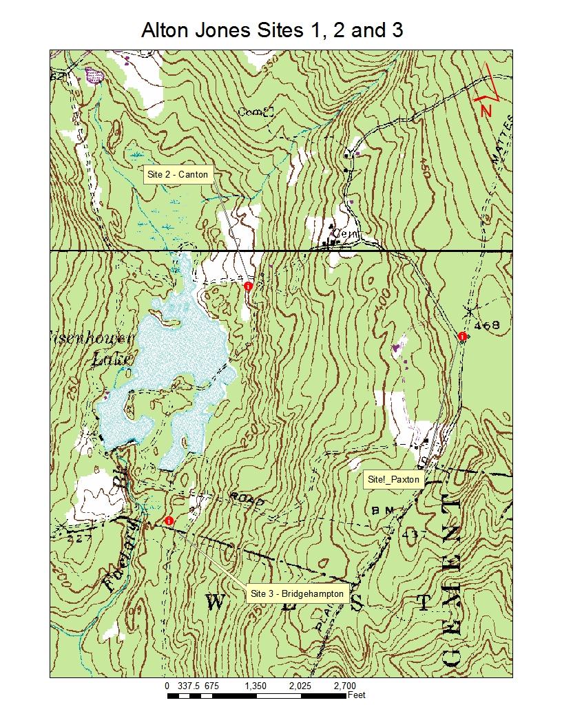
1 Directions to Soil Judging Practice Pits. Lost call Jim Turenne cell , pit location are posted at: &spn= , &z=10&msid= a47d1e Alton Jones Sites: 1 through 5 ( The W. Alton Jones Campus is located off Route 102, 2.5 miles north (102 north) of the intersection with Route 95. The entrance to W. Alton Jones is on the left (west) watch for the sign (Browns Corner Road). For folks staying at the West Greenwich Best Western take Route 95 South to the exit for route 102 north. For folks staying in Newport: get onto route 138 west which is the Newport Toll Bridge ($2 toll or $1 if you buy tokens sorry no speed pass). Follow 138 west over the Jamestown Bridge (free) and watch for exit with route 1 and 4 north. Stay on main highway which is route 4 north. Follow 4 north for about 3 miles to the exit for route 102 north. For folks staying at Holiday Inn, North Kingston: As you pull out of parking lot IMMEDIATELY get into left lane so you can get onto route 1 north at the stop light. Follow 1 north until you come to the 1 st stop light which is the route 4 merge get onto route 4 north. Follow 4 north for about 3 miles to the exit for route 102 north. Both Newport and North Kingston Folks: Follow Route 4 north to Route 102 north. Continue on 102 north past the intersection with route 3 and then 95 after you pass the route 95 exit at approximately 2.5 miles you will see the entrance to W. Alton Jones Campus and Whispering Pines Conference Center. It is about 11 miles from route 4 to Alton Jones on route 102. Site 1: Follow the entrance road to W. Alton Jones/Whispering Pines Conference Center until you come to the end of the road where you have to go either left or right (past the scenic pasture with boulders). Take a left (sign for Environmental Education Center). Follow road for 0.3 miles and watch for the sign for the Environmental Ed Center, bear to left onto a dirt road, site 1 is.2 miles from here watch for the blue and pink flags and the corner trail marker pit is to left next to dirt road. Site 2:
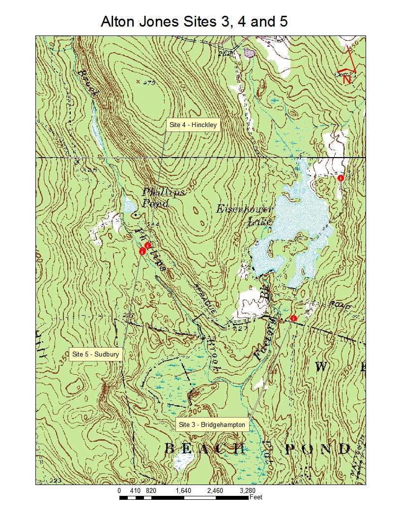
2 Follow the entrance to W. Alton Jones until you come to the end of the road past the scenic pasture with boulders. Take a right sign for Whispering Pines Conference Center. At 0.3 miles from this turn watch for a right turn into the Nettie Marie Jones Nature Preserve (Blue and Pink flags). Park in the small lot in front of the house (rest rooms there) and walk along the narrow field site 2 will be in an old borrow pit to the left (blue and pink flags). Sites 3, 4, and 5: Follow the entrance road to W. Alton Jones/Whispering Pines Conference Center until you come to the end of the road (past the scenic pasture with boulders). Take a right (Whispering Pines Conference Center). Follow the road for 0.9 miles (over a pond) until you get to a fork a sign tells you to bear right to get to conference center bear left (straight through) and follow the dirt road. Site 3 once on the dirt road at 0.1 miles watch for the blue and pink flagging and a narrow dirt road to the left, follow the dirt road over two small streams and watch for the flagging, site 3 will be on the right. Be careful driving on this narrow wood road there is one good sized bump. Sites 4 and 5: from the dirt road that split for the conference center continue on the dirt road for about 2 miles (past site 3), past the memorial for Dr. Shoop, watch for the flagging (blue and pink) the pits are on the left side up the hill (site 4) and continue west down the hill to the stream for site 5 (terrace scarp). To return back to 102 turn car around and follow dirt road out to the fork and follow signs to conference center and exit. A rest room is in the Laurel Lounge.
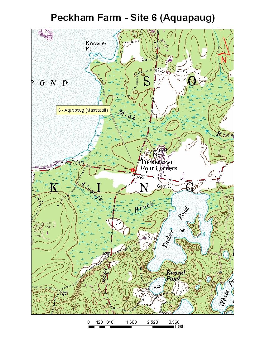
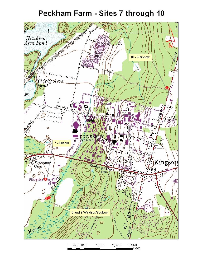
3 Peckham Farm and Associated Sites 6, 7, 8, 9, and 10 Peckham Farm is located off route 138 just west of the URI main campus entrance, across the street from the large neon sign for the Ryan Center. From West Greenwich Best Western take route 95 south to exit 3A, route 138 east (sign for South Kingstown and URI). Follow 138 east for approximately 9 miles. After you pass the stop light for route 110 the entrance to the farm is on the right just before you begin heading up a hill. From Holiday Inn North Kingston pull out of parking lot which is route 1 south and take right at light for 138 west. From Newport get onto Newport Bridge which is route 138 west, past the toll booth and continue on 138 west over the Jamestown bridge (free) follow to the end where 138 merges with route 1 south follow 138 west / route 1 south past the Holiday Inn and take a right onto 138 west (Moorsfield Road). Follow 138 west for approximately 4.4 miles, past the entrance to URI, as you get to the bottom of the hill the entrance to Peckham Farm is on the left (Blue Sign). Sites, 7, 8, and 9. To get to the soil pits follow the access road (watch for large turf vehicles), watch for blue and pink flagging. As you enter past the gate follow the dirt road and head towards the weather station to the south east. Site 7 is in the field; sites 8 and 9 are in the woods in the southeast corner. Site 6 Aquapaug: To get to site 6 head back out of Peckham Farm and take a left onto 138 west. At stop light (route 110 Ministerial Road) take a left and follow route 110 south for 3.7 miles until you get to a flashing light/stop sign. At stop sign take a right onto Wordens Pond Road and park on road just after the intersection site 6 is in wood to north, follow the pink and blue flagging. Site 10 Old North Road: from Peckham Farm take a right onto 138 east. At the stop light (entrance to URI) take a left and follow Upper College Road to the end, take a right and head up Flagg Road to the end then take a left on Old North Road the site is less than 0.5 miles on the left, look for an access road and cleared area. The pit is along the access road.
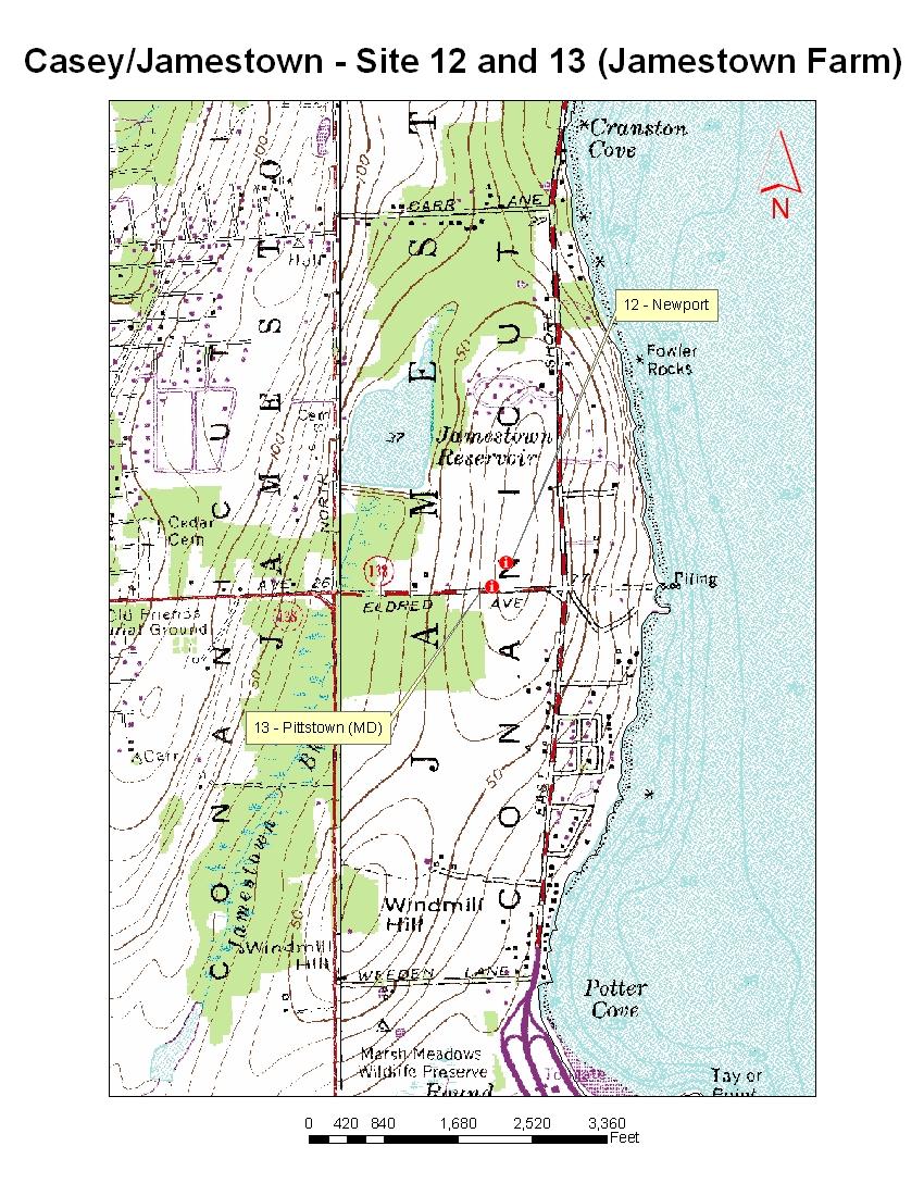
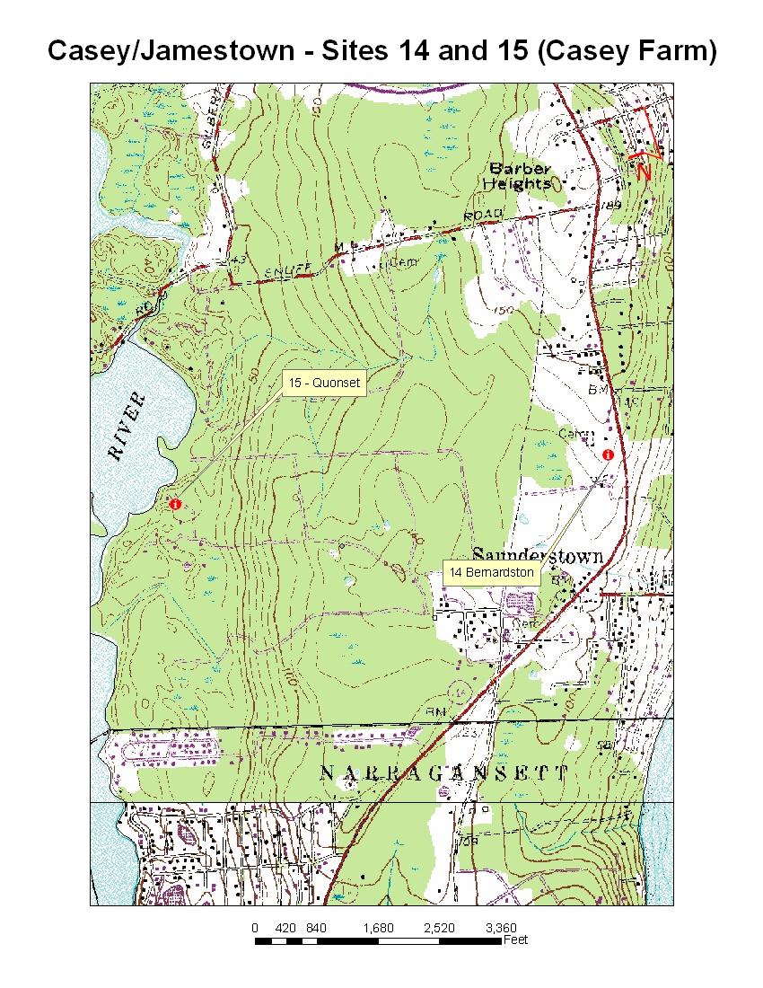
4 Casey Farm, Wilson Park, and Jamestown, Sites 11, 12, 13, 14, and 15: There are three separate locations for these pits the central drive to location will be the park and ride on route 1A at the off ramp of Route 1A and 138 in North Kingstown. Following are directions: From West Greenwich Best Western: Get onto Route 95 north and watch for the Route 2 and 4 exit (Newport and South County). Follow route 2 south for about 3.5 miles watch for exit to route 4 south. Follow route 4 south until it ends and merges into route 1 south. Take route 138 east (Newport Exit), and get off at route 1A (1 st exit) the park and ride is across street from off ramp. From North Kingston Holiday Inn: As soon as you get out of parking lot immediately get into left lane so you can head north onto route 1 at the intersection (stop light route 1 and 138). Follow route 1 north until the 138 east exit (Newport exit) follow 138 east to the 1 st exit which is route 1A the park and ride is across street from off ramp. From Newport: Take 138 west over both Newport (Toll) and Jamestown (free) bridge (If you are going to Sites 12 and 13, exit as soon as you go through the Newport Bridge toll plaza). After the Jamestown Bridge you will travel up a hill through a bedrock outcrop cut. Take 1 st exit after Jamestown Bridge and at off ramp take a right over 138 Park and Ride is on left before the Hess Station. Site 11: Wilson Park: From the Park and Ride take a right onto route 1A north, follow for approximately 3.5 miles until you get to Wickford Village (over small bridge and intersection with 102) bear right at this intersection to stay on route 1A through the village (Brown Street). At end of Wickford Village the road bears left heading back to route 1 watch for the right turn entrance to Wilson Park (swing set). Once in the park follow the road along the fields to the end, and then take a right to the boat ramp. Park at the boat ramp lot the soil pit is a coastal bluff outcrop just south of the ramp. Site 12 and 13: Jamestown Community Farm: From the route 1A Park and Ride head straight out at intersection and get onto the on ramp for 138 east. Follow 138 east over the Jamestown Bridge after you get off bridge you will follow 138 east to the exit just before the toll booth which is the Jamestown Exit (do not go past onto toll booth or you will have to pay the $2 toll). Follow off ramp to end and continue straight which will take you under the bridge. Follow the road as if you were going to get back onto 138 west but at stop sign continue straight on East Shore Drive. As a side note taking a right just after you pass under the bridge is a parking area for the beach and Taylor Point is a nice exposure of the meta-sedimentary rocks found in the area. Follow East Shore Road until a stop sign, take a left onto Eldridge Road the pits are on top of
5 the hill in the community farm, Site 13 is just north of the entrance road to the reservoir. To get back onto 138 west take the on-ramp just after the hilltop. Sites 14 and 15: Casey Farm: From route 1A Park and Ride lot take a left on route 1A south, follow 1A south for approximately 1 mile and watch for entrance to Casey Farm on the right. Site 14 is just north of the parking area in the fields to north. To get to site 15 follow the dirt farm road through fields and into the wooded area, eventually you will be heading west along a long dirt road to the boys camp. Site 15 is at the bottom of the hill follow blue and pink flagging
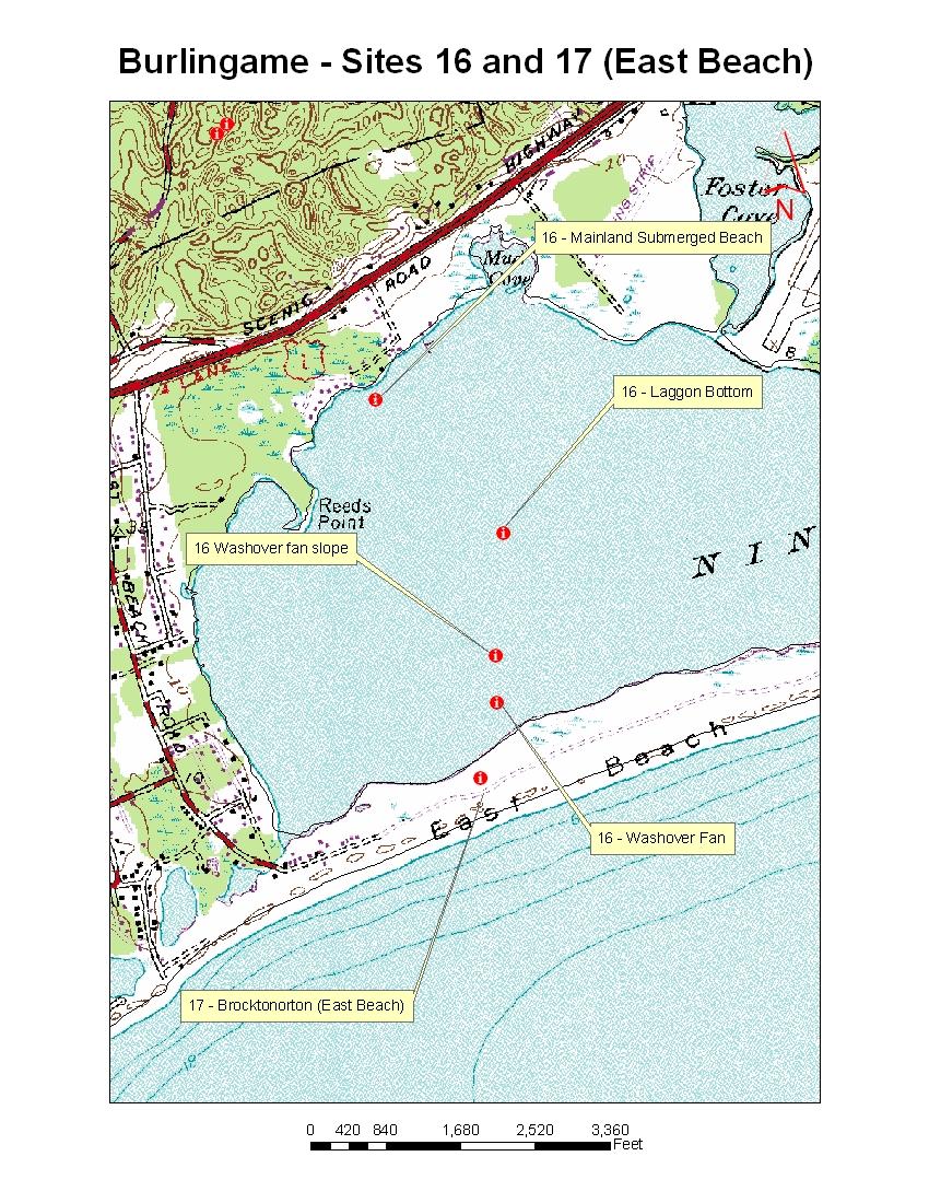
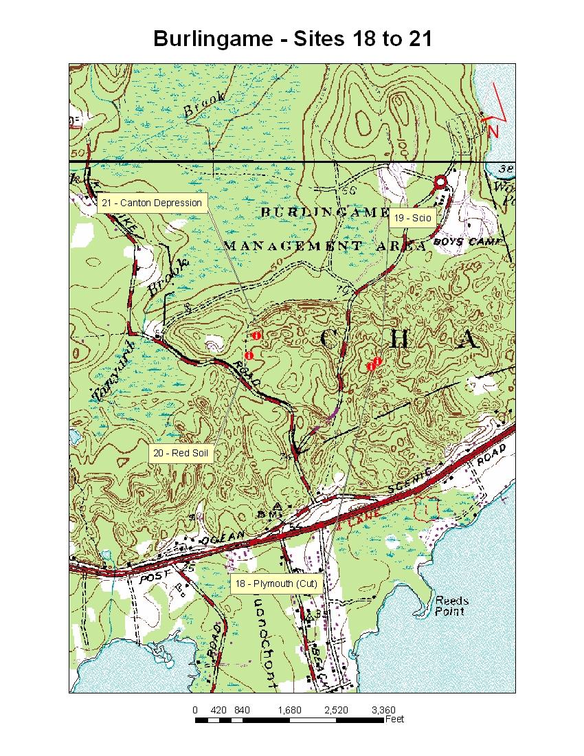
6 Burlingame Campground and East Beach Sites 16 through 21: From West Greenwich Best Western: Take route 95 south all the way into Connecticut and watch for the exit for route 2 and 78 (Westerly Beaches), take route 2 to route 78 and follow to route 1. Take a left on route 1 north, follow route 1 north for about 5.5 miles and watch for the sign for the Burlingame Camp site, there is a stop light for East Beach Road, this is a left turn (stay in left lane after you pass the Shell gas station on right). If heading to Site 16 and 17 first on route 1 at the stop light for East Beach Road, take a right follow that road all the way to end (DEM Parking). From Holiday Inn and Newport: follow route 138 west to merge with route 1 south and follow route 1 south for about 20 miles, watch for 2 nd Burlingame Campground exit called Klondike Road follow exit in to Klondike Road off Old Post Road. There is a stop light for East Beach Road a right at the stop light takes you to Sites 18 21, a left at the East Beach Road light takes you to Site 16 and 17. Sites 18 and 19: Follow the exit off route 1 to Klondike Road and the entrance to Burlingame Campground. Go past the DEM facility (stop if someone at gate and let them know who you are), shortly after the gate you will see a dirt road with a yellow gate to right, DO NOT drive into the road instead park on the opposite side of the road and walk the dirt road into the pits, follow flagging. The pits are in the NW corner of the open area, one is an old borrow pit the other in a depression just north. Sites 20 and 21: from the Klondike Road entrance continue straight past the DEM entrance and watch for a gated dirt road.3 miles past the DEM entrance. Park on Klondike and follow path north to the pits. NOTE: Mark is checking with Charlestown Police to see if OK to park on road which is signed as no parking, if the gate is open drive in until you get to pits. Site 20 is to the right of the road, 21 is up the dirt road a bit in a depression on the right look for flagging. Sites 16 and 17: From the Burlingame area head back out to the stop light (arrow pointing right to route 1). Go straight through the stop light to East Beach Road (if you need a bathroom/food go south on 1 to the next turn around and stop at the Shell gas station). Follow East Beach Road to end and bear left on bumpy dirt road. Go to the end and park in the DEM lot. Walk either along the access road (CRMC sign) or along the beach to south (Atlantic Ocean) or North (Ninigret Pond easier walk) until you get to the second clump of Pitch pines the site are located on the back barrier watch for flags. There is one pit here, be careful not to lean on sides. In the area of Pitch Pines are some subaqueous soil cores that were taken from Ninigret Pond to look at PLEASE do not pick at these cores just observe the horizons, descriptions are provided. These cores have been stored at 40F for several years and have undergone oxidation, none of the iron was present when described.
7 Directions to Duffy s Tavern From West Greenwich Best Western: Take route 95 south to the exit for route 2 and 4 (Newport). Take either route 2 south or get onto 4 south via 401 and take route 102 east (second 102 exit). Follow 102 past the Home Depot and route 2 until you get to route 1 stop light, take a left onto route 1 north Duffy s is on the left. From North Kingston Holiday Inn - get onto route 1 north by taking a left at the stop light with 138 after pulling out of parking lot. From Newport follow 138 west to the route 1 north off ramp. Follow route 1 north for about 2 miles after the split with route 4, Duffy s will be on the left just past route 102 light. Directions to Sunday Meeting Parking and area to meet on Thursday and Friday URI Fine Arts Parking. Follow the main entrance to URI on Upper College Road to the end, take a right up Flagg Road and enter the parking area.
8
9
10
11
12
13
14
15
This path goes past an old tree nursery and sawmill. After 800m it crosses over a lane. Follow the bridleway fingerpost into the woods.
 FRENSHAM PONDS 11K CIRCULAR TRAIL 2½ HRS GU10 2DA This magnificent heathland trail starts in woodland and then brings you out onto the open heather of Frensham Common, with no roadwork! The route runs
UMASS CROSS-COUNTRY Trails
 UMASS CROSS-COUNTRY Trails 1) EGG (43 min) (A) From Cage proceed to North Pleasant street (by campus pond). Make left and head toward LGRT and pass School of Education. Pass Puffton Apt complex (on left)
Greenbush Town Hall / Fire Station
 Page 1 of 18 Course Description Greenbush Town Hall / Fire Station Both races start in front of the Greenbush Town Hall / Fire Station, just south of Highway 23 on Sugarbush Road. Parking will be in the
Hiking Las Vegas.com
 Hike: Mt. Wilson via First Creek Canyon route Trailhead: First Creek marked Distance: 10 miles up and back Elevation gain: 3,400 feet Elevation of Peak: 7,070 feet Time: 7 to 9 hours (up and back) Difficulty:
We are only 3.6 miles from the Portland Bridge. You cannot see our house from the street.
 We are only 3.6 miles from the Portland Bridge. You cannot see our house from the street. FROM: RT. 80 - EXIT 4B FROM EXIT 4B, NJ, NY, Points East of exit 4B (Columbia/Portland) traveling Westbound on
EUSTACE ICE HOCKEY TRAVEL DIRECTORY
 EUSTACE ICE HOCKEY TRAVEL DIRECTORY American Hockey Center, Wall Take Route 295 North until the exit for 195 East. Take 195 East to exit 35B, Shore Points/Route 34 North. Follow 34 North to Wyckoff Road,
ATL. Advanced Technology Laboratories. Maps and Locations
 ATL Maps and Locations TABLE OF CONTENTS Lockheed Martin is headquartered in Cherry Hill, NJ with offices in Arlington, VA Eagan, MN Kennesaw, GA 3 Cherry Hill 4 Driving Directions To 5 Driving Directions
Music, Mind, and Invention Workshop Directions, Transportation, and Parking DRIVING DIRECTIONS
 Music, Mind, and Invention Workshop Directions, Transportation, and Parking GPS Address: The College of New Jersey 2000 Pennington Road, Ewing NJ 08628 DRIVING DIRECTIONS From the SpringHill Suites Ewing
HIGHWAY OPERATIONS I-95 DIVERSION ROUTE PLANS OLD LYME TO RHODE ISLAND STATE LINE
 HIGHWAY OPERATIONS I-95 DIVERSION ROUTE PLANS OLD LYME TO RHODE ISLAND STATE LINE DEVELOPED IN COOPERATION WITH THE SOUTHEASTERN CONNECTICUT COUNCIL OF GOVERNMENTS, STATE POLICE TROOP E AND LOCAL POLICE
DIRECTIONS TO THE FIELDS
 DIRECTIONS TO THE FIELDS Northwest Connecticut Babe Ruth League AVON AVON HIGH SCHOOL -Traveling east on Route 44, take a right onto Route 167. Continue on Route 167 past the Avon Middle School. The field
Directions to Gathering/other Events:
 Directions to Gathering/other Events: Scroll down the list below (churches are in alphabetical order)!! Andrews Chapel UMC: From Conway: From Conway: Take 501 to Highway 31 North. Take the Highway 9 exit
Driving Directions from San Jose Airport to Paradise Breezes
 Driving Directions from San Jose Airport to Paradise Breezes From the rental agency head towards San Jose on the airport highway. At approximately 12.5Km (approximately 10 minutes from airport) you will
Northern Virginia Community College (NOVA)-Annandale Campus STUDENT SERVICES BUILDING, ROOM CA Little River Turnpike ANNANDALE, VA 22003
-Annandale Campus STUDENT SERVICES BUILDING, ROOM CA Little River Turnpike ANNANDALE, VA 22003") Northern Virginia Community College (NOVA)-Annandale Campus STUDENT SERVICES BUILDING, ROOM CA-302 8333 Little River Turnpike ANNANDALE, VA 22003 ***We highly recommend you arrive at the school at least
Northern Virginia Community College (NOVA)-Annandale Campus STUDENT SERVICES BUILDING, ROOM CA-302 8333 Little River Turnpike ANNANDALE, VA 22003 ***We highly recommend you arrive at the school at least
C E N T R A L C A T S K I L L S
 120 C E N T R A L C A T S K I L L S Central Catskills Once out of the southern parts of the Catskills, the Long Path enters the more well traveled and civilized regions. The trail joins the Devil s Path,
Driving Directions from San Jose Airport to Villa Roselare
 Driving Directions from San Jose Airport to Villa Roselare From the rental agency head towards San Jose on the airport highway. At approximately 12.5Km (approximately 10 minutes from airport) you will
S H A W A N G U N K R I D G E T R A I L
 214 Shawangunk Ridge Trail The Shawangunk Ridge Trail was originally conceived as a relocation of the Long Path from Harriman State Park to Minnewaska State Park. Now part of the Long Path system, the
College Avenue Campus Mettler, Stonier, and Tinsley Residence Halls General Instructions: Note: From New Jersey Turnpike (North or South) NOTE:
 NOTE:") College Avenue Campus Mettler, Stonier, and Tinsley Residence Halls General Instructions: Print directions and name of assigned building. Write your room number and phone number under the name of your
College Avenue Campus Mettler, Stonier, and Tinsley Residence Halls General Instructions: Print directions and name of assigned building. Write your room number and phone number under the name of your
throu Booth Hill Green Belt
 s k r a p s l l u b m u r T Explore gh Geocaching throu Booth Hill Green Belt This was originally a concept to try and preserve some of the land in our town, without hurting the developers that are creating
Trail Beginning Elevation: 7553 ft The Poison Creek Trailhead is located at the end of National Forest Road 646E (NF-646E).
.") West Mountain Trails Poison Creek Trail #134 Length: 2.9 miles (4.7 km) Difficulty Horseback: A good trail for the first time west mountain rider, some steep sections Hiking: Most Difficult USGS Maps:
West Mountain Trails Poison Creek Trail #134 Length: 2.9 miles (4.7 km) Difficulty Horseback: A good trail for the first time west mountain rider, some steep sections Hiking: Most Difficult USGS Maps:
AOTA ArtTrek Locations
 AOTA ArtTrek Locations ArtTrek is a summer-long Grand County, CO art adventure. Highlighted by snow-covered mountain vistas and rolling meadows threaded with sparkling streams and rivers, numerous sites
SWD Sport and Wellness of Danbury (formerly Beaver Brook), 17 Starr Rd, Danbury
, 17 Starr Rd, Danbury") SWD Sport and Wellness of Danbury (formerly Beaver Brook), 17 Starr Rd, Danbury 203-743-7676 Take RT 84 East to Exit 7. Exit left onto RT 7 North. Take first exit, Federal Road, to light at bottom of exit
SWD Sport and Wellness of Danbury (formerly Beaver Brook), 17 Starr Rd, Danbury 203-743-7676 Take RT 84 East to Exit 7. Exit left onto RT 7 North. Take first exit, Federal Road, to light at bottom of exit
Helping Hands Summer Outing
 Helping Hands Summer Outing DAY 1 HHF Family & Friends Picnic/Cookout Saturday, July 15, 2017 11:00AM 4:00PM Location: The Bridge Center, 470 Pine Street, Bridgewater, MA 11:00AM-3:00PM 12:00-1:00PM 12:00-3:00PM
IAT NS CAPE BRETON - NORTH SYDNEY TO PORT HASTINGS (SOUTHBOUND)
") NORTH SYDNEY TO GRAND NARROWS - 61.4 KM WELCOME TO NORTH SYDNEY, CAPE BRETON ISLAND, NOVA SCOTIA! North Sydney is a major city with a CAPs (public internet access) & all amenities. Rollies Wharf Restaurant
NORTH SYDNEY TO GRAND NARROWS - 61.4 KM WELCOME TO NORTH SYDNEY, CAPE BRETON ISLAND, NOVA SCOTIA! North Sydney is a major city with a CAPs (public internet access) & all amenities. Rollies Wharf Restaurant
Merritts Traverse. 1928m
 Merritts Traverse 3 hrs Hard track 5.8 km Circuit 4 167m This walk starts with a scenic journey to the top of the hill on the chairlift. Starting along Merritts Nature walk, this walk soon detours down
Griffith Park Trail Run Trail Guide Click for
 The Griffith Park Trail Run by Hike- LosAngeles.com Griffith Park Trail Run Trail Guide Click for downloadable cell phone guide and map from EveryTrail. DISTANCE: 4.55 Miles ELEVATION: 1280' ELEVATION
Directions to Frequently Visited C & O Canal Locations
 Directions to Frequently Visited C & O Canal Locations Seneca Creek Montgomery County, Maryland Pass town of Potomac and Falls Road and continue west to Seneca Rd. Turn left on Seneca Rd. and continue
On The Trail. Twelve Mile Run and Kunes Camp Trail ---splendid solitude! By Gary Thornbloom
 On The Trail Twelve Mile Run and Kunes Camp Trail ---splendid solitude! By Gary Thornbloom Twelve Mile Run is about as isolated as you can get in the Quehanna Wild Area. You will find solitude and silence
DIRECTIONS. To the Pitch: Ives Estates Park NE 16 th Avenue, Miami, FL 33179
 DIRECTIONS To the Pitch: Ives Estates Park 20901 NE 16 th Avenue, Miami, FL 33179 From LaQuinta: Follow NW 26 th Avenue/Oakwood Blvd. south toward Sheridan Street. At Sheridan Street, turn right and head
Stage 2: Following the royal cattle route towards the medieval castle of the Mendozas. Tres Cantos to Manzanares el Real
 Stage 2: Following the royal cattle route towards the medieval castle of the Mendozas. Tres Cantos to Manzanares el Real 25,1 km, 6,5 hrs, é513m, ê344m, ñ661-1008m 0,0 km ñ745m Tres Cantos tvsäã 0,9 km
ALS Express Bike Ride. Saturday, June 15, 2013
 Presented by DIRECTIONS TO 75-MILE START POINT Camden County College Gabriel E Danch CIM Center 200 College Drive Blackwood, NJ **Overnight Parking in LOT 5 of the CIM Center is allowed. HOWEVER, you must
Slad over to Pitchcombe and back
 The walk climbs up from Slad over Wickridge Hill, descends to near Pitchcombe, then climbs back over Wickridge hill and round the back of Slad. Page 1 Start Point: SO 8718 0732 The Woolpack, Slad Length:
DATE COURSE TITLE LOCATION HOURS. February 27 Flow & Dynamics with Fluids, Hydraulics, and Pneumatics...Augusta *6 Sponsored by Motion Industries
 J o i n t E n v i r o n m e n t a l Tr a i n i n g C o o r d i n a t i n g C o m m i t t e e Winter/Spring 2018 JETCC Training Schedule DATE COURSE TITLE LOCATION HOURS February 22 Care of Emergency Generators...Orono
Ala-Kul trekking guide.
 Ala-Kul trekking guide. The marshrutka 101 brings you to the entrance of the park. For 400 KGS, a taxi will stop between the entrance and the broken bridge, saving at least 1 hour of walk. Download me
Bewl Water & the High Weald
 1 Bewl Water & the High Weald Stonegate station - Stonegate - Wallcrouch - Newbarn - Cousley Wood - Wood's Green - Wadhurst station Length: 9 ½ miles (15.3km) Underfoot: Large portions of this path are
Exit 136 (Centreport Parkway/Stafford County) to Exit 130 (Route 3/Fredericksburg)
 to Exit 130 (Route 3/Fredericksburg)") RELEASE: IMMEDIATE Feb. 22, 2019 CONTACT: Darragh Frye 540-907-8409 (mobile) VDOT HOT SPOTS IN THE FREDERICKSBURG DISTRICT Feb. 24 March 2, 2019 All work is scheduled weather permitting. Real-time information
RELEASE: IMMEDIATE Feb. 22, 2019 CONTACT: Darragh Frye 540-907-8409 (mobile) VDOT HOT SPOTS IN THE FREDERICKSBURG DISTRICT Feb. 24 March 2, 2019 All work is scheduled weather permitting. Real-time information
Directions to the MITRE Facility in McLean, Virginia:
 Directions to the MITRE Facility in McLean, Virginia: Take the Beltway, I-495 to Virginia. Take Exit 46B (McLean, Route 123). Take Route 123 North, (also called Dolley Madison Blvd.) and go to the second
Telluride-to-Moab Alternative Singletrack Options
 Telluride-to-Moab Alternative Singletrack Options Day 1 Day 1 Alternate 1: Galloping Goose to Deep Creek. 18.4 miles, ascent 3,530ft, descent 1,388ft. This is fun, flowey, moderate to intermediate singletrack
2015%Ironbound%Spring%Warmup% Directions!
 Riverfront Park 3 Brill St (Corner of Brill St and Raymond Boulevard) GSP Parkway: EXIT 145 to Route 280 East Exit 16 (Harrison Ave), make right at F.E. Rodgers Blvd, go past Wendy's, Path Station, cross
 BROWARD DEANERY 1 ALL SAINTS (954) 467-6496 333 Tarpon Dr. Ft. Lauderdale, FL 33301 4 INTERCESSION (954) 763-5986 501 N.W. 17 St. Ft. Lauderdale, FL 33311 I-95 to Broward Blvd. exit. Go east on Broward
Map: Landranger #27 Forres and Nairn and 36 Grantown and Aviemore
 THE DAVA WAY This is a newly created long distance route that runs from Forres to Grantown, mostly following the old railway line. You will need to detour around a couple of sections that are not really
Route Combo) Mt. Bierstadt - Bierstadt, Sawtooth, Evans
 Mt. Bierstadt - Bierstadt, Sawtooth, Evans") Climbing 14ers can be very dangerous, please read the Mountaineering Safety Page and make sure you have a map+compass and can use them effectively, without the help of electronic devices. Route Combo)
Climbing 14ers can be very dangerous, please read the Mountaineering Safety Page and make sure you have a map+compass and can use them effectively, without the help of electronic devices. Route Combo)
Blue route. Metric CENTURY (63 mi.) Rest Stops Open STOP. Follow. Dogfish Head 8 12 Irish Eyes 9 1 Firehouse Sta on 3 Robinsonville Road 10 2
 Rest Stops Open STOP. Follow. Dogfish Head 8 12 Irish Eyes 9 1 Firehouse Sta on 3 Robinsonville Road 10 2") Metric CENTURY (63 mi.) Follow Blue route Rest Stops Open 0 West Leave DelTech, West on Seashore Hwy. (Rt. 404) 1.3 Right Piglet Path (Rt. 522) 2.7 Le Wilson Hill Rd. 3.5 Right Hun ng Club Road 4.9 Right
Metric CENTURY (63 mi.) Follow Blue route Rest Stops Open 0 West Leave DelTech, West on Seashore Hwy. (Rt. 404) 1.3 Right Piglet Path (Rt. 522) 2.7 Le Wilson Hill Rd. 3.5 Right Hun ng Club Road 4.9 Right
ANITA LOUISE EHRMAN - Greenway Avenue/Armonk/10504
 Directions to Area Swim Clubs: ANITA LOUISE EHRMAN - Greenway Avenue/Armonk/10504 From north, take 684 south to exit 3, left at end of exit ramp onto route 22 north, left at blinker light at Yellow Barn
START - UPHILL BEACH. (tidal!) The West Mendip Way is route-marked with these round blue signs
 The West Mendip Way is route-marked with these round blue signs") START - UPHILL BEACH Start Times: 10:30 11:15 12:00 Please allow sufficient time to check in with the marshals Start on the beach at the high water line (tidal!) The West Mendip Way is route-marked with
START - UPHILL BEACH Start Times: 10:30 11:15 12:00 Please allow sufficient time to check in with the marshals Start on the beach at the high water line (tidal!) The West Mendip Way is route-marked with
Bikes talk to each other like dogs, they wag their wheels and tinkle their bells, the riders let their mounts mingle.
 Bikes talk to each other like dogs, they wag their wheels and tinkle their bells, the riders let their mounts mingle. Daniel Behrman, The Man Who Loved Bicycles W hitmore Lake Loop route: Dexter, the corner
Bratt ") 4. % F l o r i d a D e s i g n a t e d P a d d l i n g T r a i l s ") 164 «97 ") 99. Barrineau Park. M a p 1. M a p 2.
 4. % F l o r i d a D e s i g n a t e d P a d d l i n g T r a i l s ) 164 «97 ) 99. Barrineau Park. M a p 1. M a p 2.") F l o r i d a D e s i g n a t e d P a d d l i n g T r a i l s Bratt ") 4 Bluff Springs «4 Jay ") P e r d i d o R i v e r P e r d i d o CR R99A i v Walnut e r Hill ") 164 ") 97A «89 «97 ") 197 Barrineau
F l o r i d a D e s i g n a t e d P a d d l i n g T r a i l s Bratt ") 4 Bluff Springs «4 Jay ") P e r d i d o R i v e r P e r d i d o CR R99A i v Walnut e r Hill ") 164 ") 97A «89 «97 ") 197 Barrineau
Additional Information & Directions Center for Creative Retirement Trips, Tours, and Off-Campus Classes
 Additional Information & Directions Center for Creative Retirement Trips, Tours, and Off-Campus Classes Please note that several of these trips and tours include a materials fee for admission and/or meals.
Maine RV Parks and Campgrounds
 1 Maine RV Parks and Campgrounds Wilderness Edge Campground Brief Description: We are located in the heart of Moose country just minutes from Baxter State Park, Mt. Katahdin, and The Katahdin Woods & Waters
Directions. IBM Recovery Center One Evertrust Plaza Jersey City, NJ From World Trade Center site (Downtown New York City):
:") Directions IBM Recovery Center One Evertrust Plaza Jersey City, NJ 07302 1. Path Train From World Trade Center site (Downtown New York City): - Path Train service from World Trade Center site to Exchange
Directions IBM Recovery Center One Evertrust Plaza Jersey City, NJ 07302 1. Path Train From World Trade Center site (Downtown New York City): - Path Train service from World Trade Center site to Exchange
Hindhead, Keffolds Copse and Gibbet Hill
 point your feet on a new path, Keffolds Copse and Gibbet Hill Distance: 6 km=4 miles Region: Surrey Author: Schwebefuss Refreshments: Punch Bowl Café moderate walking Date written: 14-apr-2015 Last update:
The Croatan MST Segment 16B
 1 Mountains-to-Sea Trail Last Updated 1/1/2017 A sandy road through longleaf pine savanna in the Croatan National Forest Photo by PJ Wetzel, www.pjwetzel.com The Croatan MST Segment 16B STELLA TO THE NEUSIOK
Directions to Local Offices. Call for directions to any office NJ-LAW
 Directions to Local Offices Call for directions to any office 800-34-NJ-LAW Edison (Main Office) 2 Lincoln Hwy. (Route 27), Edison (732) 494-2727 Garden State Parkway: Get off at Exit 132. Make a right
beach. Make the ford and follow the trail out to the junction with Red Creek Tr in an open grassy area.
 Description: This is a moderate to slightly strenuous 22.8 mile backpack (add 2.6 miles if you do the packless out and back to the Lion s Head) that will have you exploring nearly every thing that is The
Bonaqua Mountain Hardware Action Sprint 2013 Discovery Bay,Lantau The Course Route
 Bonaqua Mountain Hardware Action Sprint 2013 Discovery Bay,Lantau The Course Route The start is inside the Discovery Bay plaza and leads out to the main sandy beach where you will run to the end of the
2017 Map, Parking and Directions
 Aloha! Thank you for signing up for our Making Strides Against Breast Cancer Honolulu 5k Walk 2017! We are happy you will be joining us at Ke'ehi Lagoon Beach Park for this event. We are only days away!
Sponsored by. statestreet.com
 /STATESTREETISLANDWALK #ISLANDWALKJSY Sponsored by statestreet.com Important Information If you forget everything else PLEASE remember the following.» Remember to check OUT of every checkpoint» If you
BEGINNER. mayorsmtbchallenge.org
 mayorsmtbchallenge.org Redding s second local Mountain Bike Challenge uniting current and new bicyclists in a friendly self-competition highlighting our diverse trail system. BEGINNER N Churn Creek Greenway
The Mendip Way. Route Directions and Maps Uphill to Wells
 The Mendip Way Route Directions and Maps Uphill to Wells Website: www.mendiphillsaonb.org.uk Email: mendip@mendiphillsaonb.org.uk Facebook & Twitter: @MendipHillsAONB Phone: 01761462338 1 Uphill to Loxton
HIKING/BIKING IN MERRITT AREA
 HIKING/BIKING IN MERRITT AREA Coquihalla Lakes: Just inside the southern boundary of BC Park's Coquihalla Summit Park, a nice little twin lakes paddle with a private campground & lodge is the Coquihalla
Difficult Run Stream Valley Park
 Difficult Run Stream Valley Park The more intense mountain bikers have known about for Difficult Run for some time. Equestrians have known it longer. Eight miles of unpaved trail, the Rails to River Trail
TETRA TECH AMT 1515 Wilson Blvd. Suite 1100 Arlington, VA USA (703)
") DIRECTIONS TO HEADQUARTERS Included in this Guide: Directions to Tetra Tech 1 AMT Headquarters Parking Information 1 FAA National 2 Headquarter Locations Shuttle Schedule 2 Service to FAA Buildings Closest
DIRECTIONS TO HEADQUARTERS Included in this Guide: Directions to Tetra Tech 1 AMT Headquarters Parking Information 1 FAA National 2 Headquarter Locations Shuttle Schedule 2 Service to FAA Buildings Closest
Baggy Point, Croyde, North Devon
 Baggy Point, Croyde, North Devon A walk using the South West Coast Path that is likely to be suitable for people with impaired mobility or with a pushchair, wheelchair, or mobility scooter. The Coast Path
BISHOPSTONE CIRCULAR WALK
 BISHOPSTONE CIRCULAR WALK 4½ miles (7¼ km) - allow 2 hours (see maps on final pages) Introduction This walk is within the North Wessex Downs Area of Outstanding Natural Beauty and starts from the small,
IRON BARK and COLENSO HUTS 260 Series Map: 1:50, U21 NZ Grid GPS: Geodetic Datum 1949
 IRON BARK and COLENSO HUTS 260 Series Map: 1:50,000 260-U21 NZ Grid GPS: Geodetic Datum 1949 Topo50 Map: BK36 Taoroa Junction GPS: on WGS84 How to get to START: Exit Taupo on SH1 down the lake to Turangi
CRANBERRY. Introduction
 Introduction Introduction The Cranberry Boulders are a group of 60 problems set in a beautiful mossy forest above the Cranberry Creek. The boulders are located approximately 36km south of Revelstoke on
Victoria Falls and Grose Valley to Blackheath Station
 This walk explores a fantastic section of the Grose Valley. Starting above Victoria Falls, the walk explores the cascades before dropping into the valley for the first nights rest at Burra Korain campsite.
Cell: Cell: Jennifer Jones, Program Assistant Office:
 Welcome to the University of New Hampshire. We hope to make your visit with us as comfortable and worry- free as possible. To that end we have provided this information sheet detailing what the area has
1. Drive to Lake Cowichan via Highway 18 (which connects to the Trans-Canada Highway just north of Duncan)
") Driving Instructions to the Walbran Valley via Lake Cowichan (updated July 2018) 1. Drive to Lake Cowichan via Highway 18 (which connects to the Trans-Canada Highway just north of Duncan) 2. At the traffic
Driving Instructions to the Walbran Valley via Lake Cowichan (updated July 2018) 1. Drive to Lake Cowichan via Highway 18 (which connects to the Trans-Canada Highway just north of Duncan) 2. At the traffic
East Juniata High School Phone:
 Annville-Cleona High School Phone: 717-867-7703 500 South White Oak Street Annville, PA 17003 Take 147 South to 322 East to 81 North. Take the Annville/Indiantown Gap Exit. Pick up Route 934 East (Annville
INSTITUTE OF FOOD TECHNOLOGISTS
 June 2006 INSTITUTE OF FOOD TECHNOLOGISTS The Society for Food Science and Technology Western New York Section Volume 64 Issue 4 WNYIFT 2005-2006 E XECUTIVE COMMITTEE Past Chair Phil Brown Upstate Farms
Amtrak service available to Virginia Beach, (800)
") GETTING HERE TIPS FOR Getting Here From the West: I-6, U.S. 60 or U.S. 58; From North & South: I-85, I-95, U.S. 17 or U.S. 1. These intersect with I-6 which connects with I-26 East, leading directly to
GETTING HERE TIPS FOR Getting Here From the West: I-6, U.S. 60 or U.S. 58; From North & South: I-85, I-95, U.S. 17 or U.S. 1. These intersect with I-6 which connects with I-26 East, leading directly to
BRR Leg 1 (3.9 miles, Easy)
") BRR Leg 1 (3.9 miles, Easy) Min 3901 Max 4919 Ascent +21 Descent -1031 0.0 Start (Grayson Highlands State Park Visitor Center) 3.9 Grayson Highlands State Park Office & Gate, on R (EZ 1) Leg Notes: Minimal
BRR Leg 1 (3.9 miles, Easy) Min 3901 Max 4919 Ascent +21 Descent -1031 0.0 Start (Grayson Highlands State Park Visitor Center) 3.9 Grayson Highlands State Park Office & Gate, on R (EZ 1) Leg Notes: Minimal
URI Unisex/Gender Neutral Facilities List
 University of Rhode Island DigitalCommons@URI Lesbian Gay Bisexual Transgender Queer Center The Community, Equity, & Diversity Collections 2011 URI Unisex/Gender Neutral Facilities List 5-12-11 Joseph
Florida Weekend Schedule
 Ueshiro Shorin-Ryu Karate USA Under the Direction of Hanshi Scaglione Florida Weekend Schedule Thursday February 4 th Monday February 8 th 2010 Year of the Tiger Please note several numbered training locations
F.O.K.O.S. Friends of Kingston Open Space A GUIDE TO KINGSTON OPEN SPACE
 F.O.K.O.S. Friends of Kingston Open Space A GUIDE TO KINGSTON OPEN SPACE Friends of Kingston Open Space (FOKOS) was formed when a handful of concerned citizens joined together to learn what could be done
Ocean County Brian Berkowitz (Partner Adam Nassr Monmouth County)
") Ocean County Brian Berkowitz (Partner Adam Nassr Monmouth County) 1. County Summary Ocean County, founded in 1850, is located along the Jersey Shore in the state of New Jersey and has been one of the fastest
Ocean County Brian Berkowitz (Partner Adam Nassr Monmouth County) 1. County Summary Ocean County, founded in 1850, is located along the Jersey Shore in the state of New Jersey and has been one of the fastest
Using Agile Principles to Deliver Real Business Value at Scale
 American Society for Quality (ASQ) Washington, DC & Maryland Metro Section (509), Software Special Interest Group (SSIG) IEEE Computer Society Washington, DC & Northern Virginia Chapters Society for Software
Directions to MassDEP Offices
 Directions to MassDEP Offices 1. Headquarters, Boston 2. Western Region, Springfield 3. Southeast Region, Lakeville 4. Central Region, Worcester New Address Effective November 17, 2014 5. Northeast Region,
July & August, 2018 (Sunday-Thursday) September, 2018 (Sunday-Thursday) October 1-13, 2018 (Sunday-Thursday) December, 2018 (7 days a week)
 September, 2018 (Sunday-Thursday) October 1-13, 2018 (Sunday-Thursday) December, 2018 (7 days a week)") BRISTOL HARBOR INN When making reservations, a block of rooms has been reserved under the name of the training that you will be attending so please be sure to indicate the name of the training so that
BRISTOL HARBOR INN When making reservations, a block of rooms has been reserved under the name of the training that you will be attending so please be sure to indicate the name of the training so that
CELEBRATE WEST GREENWICH GEOCACHING THROUGHOUT WEST GREENWICH
 CELEBRATE WEST GREENWICH GEOCACHING THROUGHOUT WEST GREENWICH The West Greenwich Land Trust (WGLT) is sponsoring Celebrate West Greenwich, an event designed to celebrate the beauty and history of scenic
Great Ocean Road Two Day Tour
 www.greatoceanroad.vc Great Ocean Road Two Day Tour This two day trip of approximately 530 kilometre starts from Melbourne and provides a good overview of features along the Great Ocean Road between Anglesea
Cleveland Photographic Society Amish Country Field Trip Saturday, August 15, 2015
 Cleveland Photographic Society Amish Country Field Trip Saturday, August 15, 2015 Trip Coordinator: Rob Erick 440-570-3352 Feel free to call or text along the way with any questions This trip is planned
CORTLANDT Charles Cook Pool (914) Furnace Dock Road/Cortlandt Manor/10567 From Yorktown, take Route 202 west. Go past Cortlandt Farm Mark
 Furnace Dock Road/Cortlandt Manor/10567 From Yorktown, take Route 202 west. Go past Cortlandt Farm Mark") BEDFORD GOLF & TENNIS Club (914) 234-4106 535 Cantitoe Street/Bedford/10506 Located on route 22 approximately one mile east of Bedford Village and one mile west of Bedford Center Road. Pool located past
BEDFORD GOLF & TENNIS Club (914) 234-4106 535 Cantitoe Street/Bedford/10506 Located on route 22 approximately one mile east of Bedford Village and one mile west of Bedford Center Road. Pool located past
DRAGON DOOR PUBLICATIONS
 DRAGON DOOR PUBLICATIONS 5 East County Road B, Suite 3 Little Canada, MN 55117 Phone: 651-487-2180 FAX: 651-487-3840 E-mail: support@dragondoor.com Russian Kettlebell Challenge Certification Workout Location
About the Conference Location and Accommodation
 About the Conference Location and Accommodation How to arrive to IMDEA Materials Institute IMDEA Materials Institute is located at the Scientific and Technological Park of the Polytechnic University of
Camp Jack Wright PERMANENT ORIENTEERING COURSE (2004)
") Camp Jack Wright PERMANENT ORIENTEERING COURSE (2004) WHAT IS ORIENTEERING? The skill which enables a person to navigate with a map. In the competitive sport, the winner is the person who finishes in the
Camp Jack Wright PERMANENT ORIENTEERING COURSE (2004) WHAT IS ORIENTEERING? The skill which enables a person to navigate with a map. In the competitive sport, the winner is the person who finishes in the
BEAVER LAKE ACCESS AREA SUMMARY 2017 Edition
 BEAVER LAKE ACCESS AREA SUMMARY 2017 Edition DEVELOPED BY THE BEAVER LAKE PROPERTY and SAFETY COMMITTEE 2 October 2017 1 NOTICE: This document supersedes and nullifies all previous versions of Beaver Lake
Drive and Stop Routes
 Drive and Stop Routes Limantour Road 1 - easy and likely productive. From Bear Valley Visitor Center drive back out and turn left onto Bear Valley Rd. Turn left at Limantour Road (the first road). Drive
Construction of Interstate 91 in Derby
 Construction of Interstate 91 in Derby by Dr. Allen Yale The Interstate Highway System As early as the Great Depression and again after World War II there was a recognition that the nation needed a transcontinental
79.8. Pass CG Office, follow road into camping area to USARC Campsites. Use caution, rough pavement/dirt road. 61.0
 Day 1 Turns and approximate mileage Depart USARC 7128 0.0 L Goldmine Dr.06 R Clubview Dr 0.1 L Moonridge Rd 1.0 R Bear RT onto Moonridge Way 1.9 R Big Bear Blvd 2.0 L Stanfield Cutoff 2.8 R North Shore
Wakefield Music Boosters 60 Farm Street, Wakefield, Massachusetts (781)
") Wakefield Music Boosters 60 Farm Street, Wakefield, Massachusetts 01880 (781) 246-6440 Welcome! We are delighted that your marching band is participating in NESBA Wakefield on October 7, 2017, with performances
Wakefield Music Boosters 60 Farm Street, Wakefield, Massachusetts 01880 (781) 246-6440 Welcome! We are delighted that your marching band is participating in NESBA Wakefield on October 7, 2017, with performances
Eakin Community Park. Getting There
 Eakin Community Park Quiet woods along the Accotink Creek are the hallmark of Eakin Community Park. Actually a string of smaller parks, Eakin is made-up of Mantua Park, Kern Drive Park, Eakin Park, Woodburn
Jersey Shore Council 21 st Annual Six Flags Great Adventure Camporee 2015
 Jersey Shore Council 21 st Annual Six Flags Great Adventure Camporee 2015 Date: Friday, April 17 th - Sunday, April 19 th Place: Six Flags Great Adventure & Wild Safari, 1 Six Flags Boulevard, Jackson,
9 th Annual Cornell Law School
 9 th Annual Cornell Law School Inter-University Graduate Student Conference Cornell Law School Myron Taylor Hall Ithaca, NY 14850 April 12-13, 2013 CONTENTS Contact Information... 2 Welcome. 3 Myron Taylor
Lake Wissota Access Locations within the LaFayette Township. By Chad Martin
 Lake Wissota Access Locations within the LaFayette Township By Chad Martin Anson/ Wissota Access Point # 1 Road: 195 th St. Associated Fire Numbers: 13294 Defining Characteristics: Forested from road
Stephens State Park Trails
 TRAILS OF ALLAMUCHY MOUNTAIN & STEPHENS STATE PARKS Allamuchy Mountain and Stephens State Parks contain 28 marked trails providing access to diverse landscapes for walking, hiking, biking, bird-watching,
The Physical Geography of Long Island
 The Physical Geography of Long Island A Bit About Long Island Length 118 miles Brooklyn to Montauk Geo202 Spring 2012 Width 23 miles at it s widest Area 1,400 square miles Formation of Long Island River
GRINDLEFORD GALLOP 2018
 GRINDLEFORD GALLOP 2018 Route Information The Grindleford Gallop follows a fixed 21 mile route through the lanes and paths of Derbyshire. All competitors must follow this route. An OS map of the area with
Today s Risks Facing Software Development Efforts in Your Company
 American Society for Quality (ASQ) Washington, DC & Maryland Metro Section (509), Software Special Interest Group (SSIG) IEEE Computer Society Washington, DC & Northern Virginia Chapters Society for Software
Glacial Geomorphology Exercise
 James Madison University Field Course in western Ireland Glacial Geomorphology Exercise 3-day road log (abbreviated) Striations Large kame terrace Cirque with moraines Kame delta Striations Eskers Raised