TRAIL GUIDE WINDSOR ESSEX PELEE ISLAND WELCOME TO
|
|
|
- Vernon Jeffry Singleton
- 6 years ago
- Views:
Transcription
1
2


3 WELCOME TO WINDSOR ESSEX PELEE ISLAND TRAIL GUIDE The Windsor, Essex and Pelee Island region is special in many ways. It supports a higher diversity of plant and animal species than any other in Canada, including the highest concentration of globally rare species in Ontario. Our landscape varies from quaint waterfront towns to richly fragrant vineyards; from productive agricultural lands to bustling urban centres; and from unique natural areas to beautifully manicured parks. And our region s network of trails connects us all. Trails support active lifestyles to improve the health of all our residents, including persons with disabilities, young people and seniors. Trails can also attract visitors to our region to create jobs and support the local economy. In fact, the Ontario Trails Council estimates that trails contribute at least $2 billion a year to the provincial economy. Trails allow us to conserve and appreciate the local environment, leading people through diverse plant and animal habitats, connecting us with the natural environment. The Windsor, Essex and Pelee Island region boasts hundreds of kilometres of trails through natural terrains and urban areas. Walking, running, rollerblading, hiking or biking, we have a trail to meet every need and encourage all types of outdoor adventure. Whether you are planning a stay-cation, a vacation, or an afternoon of fun, get outdoors and experience all that this region has to offer.
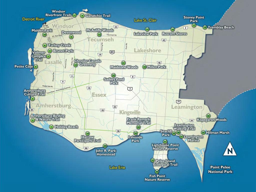
4 Table Of Contents Page Page Healthy Trails - Healthy People Ruscom Shores Trail Code of Ethics - Respecting Yourself, Others 17 Conservation Area Stoney Point Park & the Environment Tremblay Beach 1 Holiday Beach Conservation Area Conservation Area Harrow Participark Trail Amherstburg Birding & Nature Trail John R. Park Homestead Conservation Area Amherstburg Culture Trail Maidstone Conservation Area Brunet Park Sadler s Pond Park Petite Côte Conservation Area Frank Remark Memorial Trail Turkey Creek Lakeside Park Vollmer Complex Trail Hillman Marsh Conservation Area Devonwood Conservation Area Kopegaron Woods Conservation Area Ganatchio Trail Leamington Marina Malden Park Leamington Walking Trail Windsor Riverfront Trails Seacliff Park Chrysler Canada Greenway Fish Point Nature Reserve McAuliffe Woods Conservation Area & Urban Trail Lighthouse Point Nature Reserve Lakeview Park Pelee Island 15 Millen Park Ecological Trail For the purposes of this guide, limestone screening refers to fine, compacted stone surfaces suitable for walking, cycling, strollers and in most cases, wheelchairs. Note: Many trails also available at Point Pelee National Park.

5 Healthy Trails Healthy People Natural areas provide places for residents to live healthy, active lifestyles that can reduce the risk of many chronic diseases like type II diabetes, obesity, certain cancers, heart disease, stroke, depression, anxiety, arthritis and osteoporosis. Regular physical activity can help you reach and maintain a healthy weight. Physical activity promotes physical and mental well-being, and our relatively mild climate provides us many different seasonal opportunities to actively enjoy the natural surroundings of our region throughout the year. Discover the Benefits of Walking Walking is a fun and healthy activity for you and your family. It requires no special equipment or skills. An activity such as walking allows you to discover many of the beautiful sights around Windsor-Essex County. Regular walking: Increases the body s demand for oxygen and trains your heart, lungs, and muscles to work more efficiently. Increases the number of calories you expend and reduces blood pressure. Reduces fatigue and increases energy. Relieves stress and tension. Eases back pain and is easy on knee and hip joints. Can be done anywhere, anytime, and promotes a healthy lifestyle for the whole family! 2


6 Discover the Benefits of Cycling Cycling is an excellent component of a healthy lifestyle. It gets you outside to enjoy the landscape of our region. Biking is healthy for you and for the environment, as it is fuelled by natural human power. Cycling: Supports your body weight so it is less stressful on joints. Decreases risk of heart disease and high blood pressure. Increases lower body muscle strength. Helps maintain a healthy body weight. Provides personal transportation that is non-polluting. Provides a healthy way to get out and discover local trails and roads. Discover the Benefits of Cross-Country Skiing (Nordic Skiing) Cross-Country skiing is widely recognized as one of the healthiest activities that you can do and is an excellent way to enjoy outdoor activity in the winter months. It is an aerobic activity that increases the body s demand for oxygen, and trains your heart, lungs, and muscles to work more efficiently. Skiing: Uses all the major muscles in both your upper and lower body at the same time. Burns a lot of calories. (An hour of cross-country skiing burns over 900 kcal; running for the same time would burn almost 700 kcal). Is a low impact activity that reduces stress on your joints and body s tissues. Stretches your muscles while you are skiing. Increases your energy and lessens anxiety, stress and depression. 3
. Bring a map and know about potential hazards. Go with a buddy and/or let others know where and when you are going.")
 for nighttime activities. Be aware of weather conditions.")
7 Trail Code of Ethics Respecting Yourself, Others & the Environment Be Safe Carry identification and information on your personal medical concerns. Carry a mobile phone inside a waterproof container. Pack a first aid and a repair kit for equipment (if needed). Bring a map and know about potential hazards. Go with a buddy and/or let others know where and when you are going. Protect yourself from the sun with sunscreen and cover any exposed skin. Wear the right safety gear and make sure it fits properly. Be visible by using reflective tape or fluorescent paint on your equipment and gear. Bring appropriate lights (bike light or flashlight) for nighttime activities. Be aware of weather conditions. Dress in layers appropriate to the activity that you are doing. Wear appropriate, comfortable and supportive footwear. Make sure you know your limits and have fun. Refuel Your Body Think about how long you will be out. Bring snacks and a meal if necessary. A healthy snack should contain at least 2 of the 4 food groups, according to Canada s Food Guide. Include colour. Try to include at least one vegetable or fruit serving in your snack. When choosing prepackaged foods, look for ones that have less than 5% Daily Value (DV) of fat, saturated fat, and sodium. Try to include items that have 15% DV or more of fibre. Some ready to eat, healthy snacks may include: fresh fruit and vegetables, crackers, hummus, peanut butter, yogurt, granola, rice cakes, muffins, snack bars, and trail mix. 4


8 Wrap and keep hot and cold foods in separate containers or coolers. To keep foods cold, try replacing ice packs with frozen containers of drinks. Pack food in re-usable containers that you can carry. Food with less packaging is lighter to carry. Bring a hand sanitizer (at least 70% ethyl alcohol) in case you do not have access to the proper washing facilities. Replenish Natural Fluids Dehydration can cause fatigue, cramping, decreased performance and heat exhaustion. Safe drinking water is not always available. Bring water with you in a re-usable container to respect the environment. If it is a hot day or your exercise is vigorous, it is important to replace the fluid that you lost. Respect Other Trail Users Yield to and communicate with other trail users. Don t smoke on the trails. Respect private property. Keep dogs on a leash and remember to stoop and scoop. Respect the Environment Stay on marked trails. Be aware of proper activities permitted on the trail. Do not disturb vegetation or wildlife. Do not litter. 5


9 Holiday Beach Conservation Area Highlights: Length: Surface: Nearly 100 serviced and unserviced campsites. Several trails take visitors through varied habitats. Dedicated an Important Bird Area of global significance. Hosts the annual Festival of Hawks each September. 3 kilometres of trails; some are looped and some intersect. Limestone screening, footpaths, boardwalk. Managed by: Essex Region Conservation Authority Fees: Facilities: Entry fees can be found at Parking lot, campsites, laundry facilities, washrooms and showers, viewing tower, large picnic area, barbeques, swimming beaches. Directions: Located in Amherstburg. From the 401, take County Road 9 (Howard Ave) to County Road 20. Head west on County Road 20, then south on County Road 50 to Holiday Beach County Road 50, Amherstburg. 6


10 Metres LEGEND Main Trail Beach Trail Roads and Parking Camp Grounds Serviced and Unserviced Beach Marsh Field Pond Trail 7


11 Amherstburg Birding & Nature Trail Highlights: Length: Surface: Watch for deer, turtles, raccoons, and birds of all kinds. Beautiful view of Lake Erie and wetlands. One of Amherstburg s hidden treasures! 5.25 kilometres looped. Pavement, dirt and gravel. Managed by: Town of Amherstburg Facilities: Directions: Free parking at Warren Mickle Park. From 401 West, exit at County Road 9/Howard Avenue. Turn left and travel south to Alma, turn right and travel west to Sandwich Street/County Road 20. Turn left and travel south on County Road 20 to Front Road South, turn right to McLeod Avenue, turn left and travel east to Warren Mickle Park. 167 McLeod Avenue. 8


12 Metres Mann Swamp LEGEND Main Trail Roads and Parking Trail may be unsuitable for street bicycles 9


13 Amherstburg Culture Trail Highlights: Length: Surface: Key historical sites instrumental in shaping our nation today. Stop along the way to experience the stories of days past. Route markers will lead visitors from site to site. 1.5 kilometres each way. Pavement and concrete sidewalks. Managed by: Town of Amherstburg Facilities: Directions: Free parking, restrooms, restaurants, shops. Signs and trail blazers will lead visitors from the 401. From 401 West, exit at County Road 9/Howard Avenue. Turn left and travel south to Alma, turn right and travel west on Alma to Laird. Turn left and travel south on Laird to the first Amherstburg Culture Trail stop, Fort Malden National Historic Site of Canada. 100 Laird Avenue. Markers will direct users to other sites. 10


14 Metres LEGEND Paved Trail Roads and Parking 11

, with additional 1 kilometre grass nature trail. Pavement, grass.")

15 Brunet Park - LaSalle Woods Trail Highlights: Length: Surface: Paved and tree lined trails connect to the Turkey Creek and LaSalle Conservation Lands trails. Easy access for roller blades, bicycles, and wheelchairs. The nature trail is highlighted by native plants, flowers and wildlife. 3 kilometres looped (pavement), with additional 1 kilometre grass nature trail. Pavement, grass. Managed by: Town of LaSalle Facilities: Directions: Parking lot, playground, picnic shelter, benches. From Hwy #3, go south on Huron Church Line. Turn right/west on Normandy and go to Seventh Street. From Malden Road, go east on Normandy until you get to Seventh Street. Access to trails can also be found at Edgemore, Ellis, and Santa Streets. 12


16 Metres Dunkirk Ave. LEGEND Paved Trail Roads and Parking Main Trail 13


17 Petite Côte Conservation Area Highlights: Length: Surface: Environmentally friendly boardwalk constructed from recycled plastics. Viewing tower overlooking the Detroit River A Canadian Heritage River. Spot important marsh habitat and Fighting Island an International Wildlife Refuge. 0.5 kilometres each way. Boardwalk. Managed by: Essex Region Conservation Authority Facilities: Directions: Parking lot, picnic tables. Take the E.C. Row Expressway west. Continue straight onto Ojibway Parkway south, which turns into County Road 20 (Front Road). Continue south for 10 kilometres. Petite Côte will be on the west side of the road, just south of 2890 Front Road. 14


18 Metres LEGEND Main Trail Roads and Parking Forest Marsh 15


19 Turkey Creek - LaSalle Conservation Lands Trails Highlights: Length: Surface: Native Plant Garden is highlighted with birds, turtles, muskrats, cranes, deer and fish. Wheelchair accessible. Connects with Brunet Park and LaSalle Woods Trail. 5 kilometres with some looped connections and some side trails. Pavement. Managed by: Town of LaSalle Facilities: Directions: Parking lot, playground, benches. Parking lots are located at Marcotte Park. From Sprucewood Ave., go left/south on Abbott St. and the parking lot is on the left. The other parking lot is found by following Abbott St. until you reach LaSalle Street. Go south and the parking lot is at the end of LaSalle Street. 16


20 Stuart Blvd. Monty Ave. Sprucewood Ave Wales Ave. Quick Ave. Metres Ave. Reaume Ave. LEGEND Paved Trail Roads and Parking 17


21 Vollmer Complex Trail Highlights: Length: Surface: Surrounds the Vollmer Recreation Complex with baseball and soccer fields. Mountain bike trail and Skateboard Park. Connects existing, planned and new residential neighbourhoods to parks, schools, and protected wetlands and other ecologically significant lands. 6 kilometres each way. Pavement and limestone screening. Managed by: Town of LaSalle Facilities: Directions: Parking lot, playground, benches, washrooms, picnic shelter, concessions. From EC Row Expressway, exit Matchette Road south to Sprucewood (County Rd. 40). Turn left/east on Sprucewood. Head east until reaching Malden. Turn right/south on Malden. Head south on Malden until the lights at Laurier Dr. Turn left/east. Vollmer will be on your right Laurier Drive. 18


22 Metres Laurier PKWY Vollmer Culture & Recreation Complex LEGEND Paved Trail Roads and Parking 19


23 Devonwood Conservation Area Highlights: Length: Surface: Eight species of oak trees. Eastern Screech Owls, Long Eared Owls, White-tailed Deer. 38 hectare forest near an urban centre. 4.5 kilometres looped. Limestone screening. Managed by: Essex Region Conservation Authority Facilities: Directions: Parking lot, picnic tables, portable washrooms. From the 401, exit at Provincial Road, heading west. Turn right/north almost immediately on Walker Road. Travel 1.5 km. Turn left/west on Cabana Rd. and follow the curve to the right, where Cabana merges with Division Rd. for.9km. Entrance is on the north side. 20


24 Metres LEGEND Main Trail Roads and Parking Connection to Walker Homesite Park Trail 21


25 Ganatchio Trail Highlights: Length: Surface: The east/west section travels parallel to and offers spectacular views of the Detroit River. The north/south section travels through the City of Windsor arboretum and past the WFCU Centre. Highlights include the beautiful Sandpoint Beach and views of Peche Island. 8.2 kilometres. Pavement. Managed by: City of Windsor Facilities: Directions: Parking, benches, washrooms, concession at Sandpoint Beach, picnic tables, play structures. Visitors can access the trail at any point. Parking is available where the trail intersects with Florence Avenue, McHugh Street or Little River Road. 22

26 Clover Ave. Banwell Rd. Radcliffe Ave. Peche Island Lakeview Park Marina Metres Isack Dr. Isabelle Pl. Riverside Dr. E Watson Ave. Lauzon Rd. Wyandotte St. E Riverdale Ave. Martinique Ave. Sandpoint Beach Florence Ave. Clover St. Riverside Dr. E Little River Blvd. McHugh St. LEGEND Paved Trail Roads and Parking Forest Beach 23


27 Malden Park Highlights: Length: Surface: Naturalized hiking and cycling trails wind up and down the hills and through paved and wood chipped trails. Two prominent hills one is Windsor s highest peak! 25 acre Carolinian Forest. Three ponds and the Malden Park Visitor Centre. 3.5 kilometres looped within the park. Through a network of on-and-off road trails, connect with Ojibway Park and Nature Reserve, the Spring Garden Prairie, and many other sites of natural significance. Limestone screening, footpaths, some pavement. Managed by: City of Windsor Facilities: Parking lot at the east entrance, small parking area at the west entrance, washrooms, visitor centre available for rental. Directions: From Huron Church Road, head west on Malden Road Malden Road. 24

28 Metres EC Row Expressway LEGEND Main Trail Roads and Parking 25


29 Windsor Riverfront Trails Odette Sculpture Park Riverside Dr. W California Ave. University Ave. W Crawford Ave. Wyandotte St. W 26
30 Highlights: Length: Surface: Roy Battagello Riverwalk. Odette Sculpture Garden is an outdoor art gallery with large scale contemporary sculptures. Festival Plaza features many special events each year. Bert Weeks Memorial Gardens with fountain and reflecting pool kilometres each way. Pavement. Managed by: City of Windsor Facilities: Various parking lots, concession stands, playgrounds, benches. Directions: Festival Plaza Can be accessed from a number of parking lots along Riverside Drive in the City of Windsor. From 401, travel Huron Church Road to Riverside Drive. From EC Row Expressway, travel Walker Road to Riverside Drive. Bert Weeks Memorial Gardens Ouellette Ave. University Ave. E Parent Ave. Wyandotte St. E Riverside Dr. E Lincoln Rd Metres LEGEND Paved Trail Roads and Parking 27


31 28 Chrysler Canada Greenway

32 Highlights: Length: Surface: 48 kilometre trail stretching from Oldcastle to Harrow, Kingsville, and Ruthven. Meanders through rich agricultural lands, historically and architecturally significant buildings, and award winning wineries. Is the southern-most section of the Trans-Canada Trail. Intersects with the future Essex-Amherstburg Greenway. 48 kilometres. Limestone screening. Managed by: Essex Region Conservation Authority Facilities: Directions: Six community entrances along the route feature parking, washrooms, picnic facilities. Kilometre markers and interpretive signage line the route. There are access points and parking areas in each municipality as identified on the attached map, or visit our website for more information. Kingsville Centre LEGEND Main Trail Roads and Parking Metres 29


33 McAuliffe Woods Conservation Area & Urban Trail Highlights: Length: Surface: 9 hectare oak and hickory woodlot. Adjacent playground and picnic shelter. Paved sections make this very accessible for wheelchairs, walkers and strollers. 3 kilometres looped and connected with McAuliffe Urban Trail. Pavement and limestone screening. Managed by: Essex Region Conservation Authority Town of Tecumseh Facilities: Directions: Picnic area, parking lot. From County Rd. 42, head north on St. Alphonse Street, which is just west of Lesperance Road. 30


34 Metres LEGEND Main Trail Paved Trail Park Roads and Parking 31


35 Lakeview Park Highlights: Length: Surface: Amphitheatre hosts various festivals and events. Beautiful sandy swimming beach and splashpad. Fish habitat. 0.5 kilometres within the park, but connects to an on-and-off road multi-use trail that stretches 13 kilometres from the Puce River to the Ruscom River. Pavement. Managed by: Town of Lakeshore Facilities: Directions: Parking lot, washrooms, playground, concession area. From EC Row Expressway, head north on First Street to Lakeview Drive. Located adjacent to the Belle River Marina. 535 Lakeview Drive, Belle River. 32


36 Metres LEGEND Paved Trail Roads and Parking Railroad 33


, head south onto County Road 27 (Belle River Road) to")
37 Millen Park Highlights: Length: Surface: Batting Cage, volleyball court, community centre and library kilometre loop. Pavement. Managed by: Town of Lakeshore Facilities: Directions: Parking, playground area, covered shelter with tables, accessible washrooms available in the community centre. From EC Row Expressway (Hwy. 2), head south onto County Road 27 (Belle River Road) to South Middle Road East South Middle Road, South Woodslee. 34


38 Metres LEGEND Main Trail Roads and Parking 35


39 Ruscom Shores Conservation Area Highlights: Length: Surface: 120 acre marshland area perfect for shorebird and waterfowl viewing. Designated an Environmentally Significant Area. Supports habitat restoration and a tall grass prairie site kilometres each way. Limestone screening and boardwalk. Managed by: Essex Region Conservation Authority Facilities: Directions: Picnic pavilion, viewing tower, parking lot. Exit the 401 at County Rd 31 and head north for 7 km. It will jog right and then left at County Rd 42. Turn right/east on County Rd 2 (Tecumseh Rd). Travel 2.25 km. Just over the train tracks you will see the entrance on the north side. Turn on Surf Club Drive. 89 County Rd


40 Metres LEGEND Main Trail Boardwalk Roads and Parking Forest Marsh Railroad 37


41 Stoney Point Park Highlights: Length: Surface: Playground area. Soccer pitches. 1.3 kilometres looped. Pavement. Managed by: Town of Lakeshore Facilities: Directions: Parking, pavilion for seating and picnic rental, washrooms, playground. From Hwy. 2 or County Rd. 42, head north on Comber Side Road (park is behind St. Paul School Property). 800 Comber Side Road. 38


42 Metres Tecumseh Rd LEGEND Paved Trail Roads and Parking 39


43 Tremblay Beach Conservation Area Highlights: Length: Surface: One of only two marshes remaining along Essex County s Lake St. Clair shoreline. Viewing tower provides a bird s eye perspective of wildlife in the marsh. Sandy lake is ideal for paddling. 0.5 kilometres each way. Limestone screening and footpath. Managed by: Essex Region Conservation Authority Facilities: Directions: Picnic area, viewing tower, parking lot. Exit the 401 at County Rd 35/Highway 77, head north for 8 km. Turn right/east on St. Clair Rd and travel 6 km St. Clair Road. 40


44 Metres LEGEND Beach Trail Roads and Parking Beach Marsh Forest 41


45 Harrow Participark Trail Highlights: Length: Surface: Carolinian remnant forest within Harrow Centre. Part of the Harrow recreational complex in conjunction with the Harrow Arena and High School. Walking trails and butterfly park. 1.5 kilometres looped. Limestone screening and footpath. Managed by: Town of Essex Facilities: Directions: Parking, washrooms and other facilities available at the adjacent Harrow Arena. From Walker Rd. (County Rd. 11), continue south into the Town of Harrow. Walker Rd. becomes Queen St. in town. Turn left on King St./Hwy-18, then an immediate right on to McAffee St. Follow McAffee St. south and arena is at the end of the road. 243 McAffee St. 42


46 To Harrow Arena Parking, located on McAffee St Metres LEGEND Main Trail Park 43


47 John R. Park Homestead Conservation Area Highlights: Length: Surface: 1850s farm house museum. Costumed interpreters share the stories of our pioneers. Heritage based special events take place throughout the year. Boardwalk and nature trail. 0.2 kilometres each way. Boardwalk and limestone screening. Managed by: Essex Region Conservation Authority Fees: Facilities: Directions: Opening times and entry fees can be found at Museum and heritage buildings, gift shop, parking lot, picnic tables, washrooms. Located on the shore of Lake Erie between the towns of Kingsville and Colchester. 915 County Road 50 at Iler Road. 44


48 Overflow Parking Metres LEGEND Main Trail Boardwalk Trail Roads and Parking 45


.")
49 Maidstone Woods Conservation Area Highlights: Length: Surface: Indian Signal Tree. 20 hectare oak-hickory Carolinian forest. 1.5 kilometres looped. Limestone screening with forest boardwalk. Managed by: Essex Region Conservation Authority Facilities: Directions: Parking lot, picnic tables, seasonal portable washrooms. From the 401, exit south on County Rd. 25 (Puce Road). Located on County Rd. 25, just south of Country Rd Lakeshore Road 209, Lakeshore. 46

50 Metres LEGEND Main Trail Roads and Parking 47


51 Sadler s Pond Park Highlights: Length: Surface: Urban park that links directly to the Essex Amherstburg Greenway. Ponds, small dock, and picnic pavilion. Close to downtown Essex with shops and restaurants. 1 kilometre looped and connected to a 1.2 kilometre completed section of the Essex Amherstburg Greenway. This Greenway will eventually span 26 kilometres and intersects with the Chrysler Canada Greenway. Pavement. Managed by: Town of Essex Facilities: Directions: Parking, picnic pavilion. From Hwy #3, turn north on Victoria Ave. to Keown Street. Head west on Keown Street to parking lot. 48


52 Victoria Ave Metres Keown St. Victoria Ave. LEGEND Paved Trail Roads and Parking 49


53 Frank Remark Memorial Trail Highlights: Length: Surface: Stroll, run or cycle a route that transitions from small town, urban living to orchards and farmland. Ball diamonds, soccer fields, tennis courts, skateboard park, playgrounds and the arena. 0.8 kilometres with a connection to the Chrysler Canada Greenway (via a 300m walk east from the southern end of the trail). Pavement. Managed by: Town of Kingsville Facilities: Directions: Parking lot, washrooms located at adjacent Municipal Sports Complex. From Hwy #3, take County Rd. 29 (Division Rd.) south to Kingsville. Head east on Road 2 East, and then south on Jasperson Drive. 50


54 Metres LEGEND Paved Trail Roads and Parking 51


. Pavement and limestone screening.")

55 Lakeside Park Highlights: Length: Surface: Picturesque gardens, gazebos, playgrounds and volleyball court. Turn of the century pavilion and a fieldstone bridge designated under the Heritage Act. Waterfront park with mature towering trees and beach access. 1.3 kilometre network with connection to Chrysler Canada Greenway (via a 700m walk along the Cull Drive Trail and then North on Heritage Road). Pavement and limestone screening. Managed by: Town of Kingsville Facilities: Directions: Parking lot, picnic tables, washroom. From Hwy #3, take County Rd. 29 (Division Rd.) to Kingsville. Continue south on Division Street South through town. Head west on Herrington Street and south on Queen Street. 315 Queen Street. 52


56 Cull Drive Trail To Lakeside Park Metres To Chrysler Canada Greenway LEGEND Main Trail Paved Trail Roads and Parking Beach 53


57 Hillman Marsh Conservation Area Highlights: Length: Surface: Fees: Facilities: Over one hundred species of birds use Hillman Marsh as a migration stopover. Managed Shorebird Habitat provides excellent spring birding opportunities. Education Centre hosts thousands of students annually. 5 kilometres looped. Limestone screening, grass, and marsh boardwalk. Entry fees can be found at Parking lot, picnic tables, public washrooms, canoe launch, swimming beaches. Directions: Located approximately 7km east of Leamington. From Hwy 3, County Rd. 77 (Erie Street) south to Oak Street. Take Oak Street east to Hillman Marsh Mersea Road, Leamington. 54


58 Metres LEGEND Main Trail Dual Hillman and Shorebird Trails Roads and Parking Boardwalk Trail Educational Buildings Marsh Shorebird Cell Beach Forest Fred Cada Memorial Forest 55


59 Kopegaron Woods Conservation Area Photo by Karen Neufeld of Singular Perspective Highlights: Length: Surface: Spectacular spring wildflower viewing and photography. 19 hectare Carolinian forest. Excellent site for viewing spring warblers. 1 kilometre looped. Limestone screening with forest boardwalk. Managed by: Essex Region Conservation Authority Facilities: Directions: Parking lot, picnic table, seasonal portable washrooms. Located on Highway #3, just west of Wheatley, Ontario. 762 Talbot Street East, Leamington. 56


60 Metres LEGEND Main Trail Roads and Parking Forest 57


61 Leamington Marina Highlights: Length: Surface: Beautiful waterfront promenade surrounded by flowerbeds, planters and baskets. Story boards commemorating several of the shipwrecks of the Pelee Passage. Large, fully accessible play structure. 0.5 kilometres each way. Pavement. Managed by: Municipality of Leamington Facilities: Directions: Parking lot, picnic pavilion, playground, benches, washrooms. From Hwy #3, drive south on Erie Street to Robson Road. Parking lot entrance is from Robson Road. 58


62 Metres LEGEND Boardwalk Roads and Parking 59


63 Leamington Walking Trail Highlights: Length: Surface: HJ Heinz bush, named for the HJ Heinz Corporation. 2 kilometres each way. Limestone screening. Managed by: Municipality of Leamington Facilities: Directions: Parking lot is available to the Baseball Diamonds or Marina. From Hwy #3, drive south on Erie Street to Seacliff Drive. Head west on Seacliff Drive to Forest Street, and then turn south to the park gates. 60


64 Metres LEGEND Main Trail Roads and Parking 61


65 Seacliff Park Highlights: Length: Surface: 8.25 hectare park of trees and open spaces. Beautiful sandy swimming beach. Accessible playscape and splash pad. Tree carvings. 1 kilometre looped. Pavement. Managed by: Municipality of Leamington Facilities: Directions: Parking lot, picnic tables, pavilion, playground, benches, beach, splash pad, washrooms. From Hwy 3 or the 401, take Hwy 77/Erie Street to Seacliff Drive. Turn right/west off Erie St. South onto Seacliff to Forest, turn left/south onto Forest. 62


66 Metres LEGEND Paved Trail Roads and Parking Beach 63


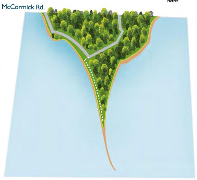
67 Fish Point Nature Reserve Highlights: Length: Surface: Located in: Facilities: Directions: The most southern tip of Canada! 110 hectare Provincial Nature Reserve featuring several provincially rare plants and animals like the Eastern Fox Snake, Lake Erie Water Snake and the Giant Swallowtail Butterfly. 0.6 kilometres each way. Wood chips and dirt with some wooden walkways. Township of Pelee Parking available at the trail entrance. Take the Pelee Island Ferry to the Island. From the dock, turn right on West Shore Road. Keep right to McCormick Road. Remain on McCormick Road until entrance to Fish Point Nature Reserve Trail. For departure times, contact Pelee Island Transport Inc. at


68 Metres LEGEND Main Trail Roads and Parking Beach 65


69 Lighthouse Point Nature Reserve Highlights: Length: Surface: Located in: Facilities: Directions: Tree lined path opens to Pelee s beautiful beaches. Beautifully restored lighthouse stands at the tip of the spit. Many rare species including the Blue Racer Snake and Eastern Spiny Soft-shelled Turtle. 1.1 kilometres each way. Wood chips and dirt with some wooden walkways. Township of Pelee Parking is marked south of the nature reserve. Take the Pelee Island Ferry to the Island. From the dock, turn left on West Shore Road. Remain on West Shore Road until it merges right to North Shore Road. Follow North Shore Road along shore. Turn left on Harris-Garno Road. Turn left on East Shore Road to the marked parking lot for Lighthouse Point Nature Reserve. 66


70 Metres LEGEND Main Trail Roads and Parking Beach 67


71 Pelee Island Ecological Trail Highlights: Length: Surface: Linked network of off and on-road trails identifying important natural and cultural destinations. In spring, witness the spectacular songbird migration. Special events held throughout the year. The Lakeview Trail is 34 kilometres around the perimeter of Pelee Island. The Noah Garno Trail connects Harris-Garno Road to Brown s Road. Pavement and gravel. Managed by: Township of Pelee Facilities: Directions: Parking available at the Ferry Dock. Washrooms, restaurants and shops along the way. From either Leamington or Kingsville, take the Pelee Island Ferry to the Island. Contact Pelee Island Transport Inc. at for departure dock and ferry times. The trail can be accessed from the Ferry Dock. 68


72 0 1 2 Kilometres Brown s Rd. LEGEND Main Trail Roads and Parking Beach Noah Garno Trail 69

73
Windsor Kingsville Essex Tour:
 An Ontario's Southwest Cycling Itinerary Windsor Kingsville Essex Tour: Pedal into the Heart of Southern Ontario s Wine Country CYCLE LOTS TO SEE AND LOTS TO DO IN ONTARIO S SOUTHWEST Total Distance: 130
TOWN OF LAKESHORE PARKS
 TOWN OF LAKESHORE PARKS Welcome! This document shows the display boards that were used for the Parks Masterplan Open Houses held on July 26, 27, and August 2, 2016 for the Town of Lakeshore. The displays
KETTLE CREEK CONSERVATION AUTHORITY TRAIL GUIDE.
 KETTLE CREEK CONSERVATION AUTHORITY TRAIL GUIDE www.kettlecreekconservation.on.ca EXPLORE OUR TRAILS HIKE OUR TRAILS Kettle Creek Conservation Authority (KCCA) proudly supports and promotes an active lifestyle
ONTARIO TRAILS COUNCIL FAQ
 Trail Facts Ontario has some of the most treasured and protected outdoor areas in the world with: 329 Provincial Parks 400 Conservation Areas 292 Conservation Reserves Many people link trails with recreation
Trail Etiquette. Hours of Operation. Trail Accessibility
 Trail Guide The Elmhurst Park District, with 28 parks and over 460 acres of land, offers nearly six miles of paved or asphalt park trails and maintains an additional 3.6 miles of trails within Elmhurst.
This Passport: Revised October 20, 2017, EAM # Discovering the Trails of Penfield, NY
 This Passport: Revised October 20, 2017, EAM #161922 Discovering the Trails of Penfield, NY The Town of Penfield is fortunate to have a wide variety of natural resources which make for many unique and
Niagara Natural Heritage Park
 A Future Proposal For the Niagara-on-the-Lake DND Lands....... Parks Canada Lakeshore Road Property 1 May, 2016 The Harmony Residents Group We are proposing a Natural Heritage Park be established on the
This Passport: Revised October 20, 2017, EAM # Discovering the Trails of Webster, NY
 This Passport: Revised October 20, 2017, EAM #161923 Discovering the Trails of Webster, NY The Town of Webster invites you to explore and experience our diverse outdoor adventures! Here s your opportunity
PLACES TO WALK IN PORT COQUITLAM
 Places to Walk in Port Coquitlam Port Coquitlam is a walker s paradise, whether you re looking for a leisurely stroll or a challenging trek. Lace up your sneakers and try out these 18 walks submitted by
249 Sherk Street, Leamington, ON, Canada N8H 4X7 Ronan P. Oliver, Manager, Leamington Marina Telephone (519) Fax (519)
 Fax (519)") 249 Sherk Street, Leamington, ON, Canada N8H 4X7 Ronan P. Oliver, Manager, Leamington Marina Telephone (519) 326-0834 Fax (519) 322-2407 Email: roliver@leamington.ca Dear Boater, Welcome to the Leamington
249 Sherk Street, Leamington, ON, Canada N8H 4X7 Ronan P. Oliver, Manager, Leamington Marina Telephone (519) 326-0834 Fax (519) 322-2407 Email: roliver@leamington.ca Dear Boater, Welcome to the Leamington
PASSPORT. Discovering the Trails of Webster, NY
 PASSPORT to family wellness Discovering the Trails of Webster, NY Join the Friends of Webster Trails, Webster Health and Education Network, The Town of Webster and Wegmans to get moving more and enjoy
Acquisition in fee simple of approximately one-half acre of property on the shore of Spring Lake to expand the Lakeside Beach Park.
 Lakeside Beach TF00-136 $122,550.00 in fee simple of approximately one-half acre of property on the shore of Spring Lake to exp the Lakeside Beach. 2000 River Ravines TF00-150 $910,000.00 in fee simple
Discover. Ashhurst Domain. Nature s Playground
 Discover Ashhurst Domain Nature s Playground Discover Step back into New Zealand, Aotearoa, of generations long gone. Discover lush natural surrounds echoing with rich birdsong in one of the Manawatu s
Summary of Small Group Discussion Notes
 THE CORPORATION OF THE CITY OF WINDSOR Parks and Facilities/ Windsor Essex Local Immigration Partnership Community Consultation: Parks for Today-Planning for Tomorrow Dec 9, 2014 Windsor Public Library
Rating: 5.0 (scale of 1-10)
") 95 Community Trail System Groundcover: 2-metre paved path, 1- metre grass buffer on either side. Location: Fort St. John Ownership: City of Fort St. John Rating: 5.0 (scale of 1-10) Strategic value: Linear
95 Community Trail System Groundcover: 2-metre paved path, 1- metre grass buffer on either side. Location: Fort St. John Ownership: City of Fort St. John Rating: 5.0 (scale of 1-10) Strategic value: Linear
Camping (Primitive) Camping (RV) Electrical Potable Water Grill Established Fire Pit Picnic Table
 Camping (RV) Electrical Potable Water Grill Established Fire Pit Picnic Table") Alden - 9th Road River Mile 777 Map: 38.20833, -98.32031 Managing Agency: Kansas Department of Wildlife, Parks & Tourism Nearest Community: Alden, Rice County Kansas Developed Amenities Provided Parking
Alden - 9th Road River Mile 777 Map: 38.20833, -98.32031 Managing Agency: Kansas Department of Wildlife, Parks & Tourism Nearest Community: Alden, Rice County Kansas Developed Amenities Provided Parking
NORTHWEST SECTION CONTENTS: CLEVELAND PARK FOLWELL PARK RYAN LAKE PARK VICTORY PRAIRIE DOG PARK VICTORY PARK
 NORTHWEST SECTION CONTENTS: CLEVELAND PARK FOLWELL PARK RYAN LAKE PARK VICTORY PRAIRIE DOG PARK VICTORY PARK LUCY LANEY COMMUNITY SCHOOL N 33RD AVE N 33RD AVE SINGLE-FAMILY RESIDENTIAL MULTI-USE DIAMOND
Lewis and Clark Recreation Area
 Lewis and Clark Recreation Area Bicycle/Pedestrian Trail Also part of the Pierson Ranch Recreation Area trail Type of trail: Walking, biking and rollerblading Trail surface: Asphalt Rated: Mostly flat.
LANDING S PARK CONCEPTUAL PLAN HAMILTON ANDERSON JANUARY City of Novi, Michigan. The Park at 13 Mile and Old Novi Road
 HAMILTON ANDERSON JANUARY 2012 LANDING S PARK CONCEPTUAL PLAN January 2012 Page 1 of 15 January 2012 PROJECT GOALS Activate the park by introducing new elements Provide clear access to the water and enhance
West Orange Trail. Clean, Green, Fun!
 West Orange Trail Clean, Green, Fun! The West Orange Trail - when completed - will be a 36-mile, multipurpose recreational greenway containing a 14-foot wide paved surface to be enjoyed by walkers, joggers,
Welcome to Schmeeckle Reserve!
 Welcome to Schmeeckle Reserve! This 280-acre natural area is staffed by University of Wisconsin-Stevens Point students. The Reserve protects habitat for native plant and animal communities, serves as a
IOWA ORNITHOLOGISTS' UNION - Birding Sites in Dallas County
 IOWA ORNITHOLOGISTS' UNION - Birding Sites in Dallas County Printed on 7/19/2018 Beaver Bottoms Wetland (restricted) (Important Bird Area) GPS Coordinates:, Ownership: Private (see directions for access)
Langton Lake Park Implementation Planning Session One 6 June Attendees signed in
 27 Attendees signed in Meeting summary Following an overview of the Parks and Recreation Renewal Program and the key directions of the Parks and Recreation System Master Plan, meeting participants were
A Vision for South Skunk River and Chichaqua Bottoms Greenbelt
 A Vision for South Skunk River and Chichaqua Bottoms Greenbelt Photo: Jim Pease Chichaqua Bottoms Booklet 7 of 8 Greater Des Moines Water Trails and Greenways 1 2016 Table of Contents Booklet 1: Water
NORTH HEMPSTEAD BEACH PARK MASTER PLAN
 NORTH HEMPSTEAD BEACH PARK MASTER PLAN COMMUNITY DESIGN CHARRETTE Supervisor Judi Bosworth Viviana L. Russell Peter J. Zuckerman Angelo P. Ferrara Anna M. Kaplan Lee R. Seeman Dina M. De Giorgio VISIONING
The striking colours of the setting sun reflecting on the waters is how Crimson Lake received its name. Crimson Lake Provincial Park is a meeting
 The striking colours of the setting sun reflecting on the waters is how Crimson Lake received its name. Crimson Lake Provincial Park is a meeting place of foothills forests in the west, bog and muskeg
Chapter eight. Parks and Recreation. Introduction. Crystal Lake Park District
 Chapter eight Parks and Recreation Introduction One of the indicators of quality of life in a city is the parks and recreation system. The City of Crystal Lake is fortunate to have an excellent parks and
CHAPTER 4 EXISTING PARKS AND RECREATION FACILITIES INVENTORY
 CHAPTER 4 EXISTING PARKS AND RECREATION FACILITIES INVENTORY Existing park and recreation sites and facilities provide the basis upon which to build a park and recreation plan for the city. This inventory
Parks PARKS. Mississauga Stewardship Opportunities. LitterNot. Parks Watch. Cemeteries. Tree planting, Naturalization and Community Garden Programs
 s Mississauga Stewardship Opportunities LitterNot Motorists and pedestrians create 30 to 50 per cent of the litter. People tend to litter in parks, roadways and sidewalks because they feel no sense of
PIONEER PARK. City of Des Peres Parks Master Plan. SWT Design 46 INTRODUCTION
 PIONEER PARK INTRODUCTION Pioneer Park is a 7 acre neighborhood park located east of Interstate 270 and south of Manchester Road along Tallie Road. The park is situated in a residential neighborhood with
2. Goals and Policies. The following are the adopted Parks and Trails Goals for Stillwater Township:
 D. PARKS AND TRAILS 1. Introduction Stillwater Township s population is relatively low, with most residents living on rural residences on large lots. The need for active park space has been minimal in
Discovering the Trails of Henrietta, NY
 This Passport: Revised June 8, 2017, EAM #161919 The Town of Henrietta is fortunate to have many wonderful trails to explore. We hope you will enjoy and protect our environment. Always be safe and please
City of Oak Harbor Parks & Descriptions
 City of Oak Harbor Parks & Descriptions North West Section Koetje Park - NE 7 th Avenue (3.5 acres) Neighborhood and Community Park with playgrounds on one tot lot, one soccer/practice field, picnic tables,
City of Haslett. City of East Lansing. City of East Lansing
 Central Park North (Nancy L. Moore Park) Lake Park North Expansion White Park Expansion #2 White Park Expansion #1 County East East Haslett East East TF87-212 Acquisition $90,000.00 Park. TF08-138 Acquisition
Selected Demolitions for Potential Parking Use
 DOUGALL AVE OUELLETTE AVE PILLETTE RD GEORGE AVE HOWARD AVE PARENT AVE CHRYSLER CENTRE DROUILLARD RD GLADSTONE AVE WALKER RD LINCOLN RD PELISSIER ST OUELLETTE AVE DUFFERIN PL DUFFERIN PL GOYEAU ST WINDSOR
experience HUNTSVILLE River Mill Park For more information contact Greg Pilling x 3027
 experience HUNTSVILLE River Mill Park Don Lough Arena Lions Lookout Algonquin Theatre Active Living Centre Pitman s Bay greg.pilling@ 705-789-6421 x 3027 diverse venues unique events memorable experiences
APPENDIX 19-II. Ontario Trail Network Trailheads EAST-WEST TIE TRANSMISSION PROJECT AMENDED ENVIRONMENTAL ASSESSMENT REPORT
 EAST-WEST TIE TRANSMISSION PROJECT AMENDED ENVIRONMENTAL ASSESSMENT REPORT APPENDIX 19-II Ontario Network heads Report. 1536607/2000/2219 Ontario Network heads in the n-commercial Land and Resource Use
To Wellness. To Wellness PASSPORT PASSPORT. Partners. Partners. Ashland County Health & Human Services 630 Sanborn Avenue, Ashland, WI
 Partners Ashland County Health & Human Services 630 Sanborn Avenue, Ashland, WI Ashland Bretting Center 320 4th Avenue W., Ashland, WI PASSPORT Bayfield County Health Department 117 E. 6th Street, Washburn,
J. Recreation Plan of Conservation and Development. The Town of Hebron. Section 2. Preservation of Unique Assets. 1 P a g e
 The Town of Hebron Section 2 2014 Plan of Conservation and Development Preservation of Unique Assets J. Recreation Open spaces, parks, sports fields, and recreational programs are considered essential
Winnipeg Beach Provincial Park. Draft Management Plan
 Winnipeg Beach Provincial Park Draft Management Plan 2 Winnipeg Beach Provincial Park Table of Contents 1. Introduction... 3 2. Park History... 3 3. Park Attributes... 4 3.1 Natural...4 3.2 Recreational...4
County of Peterborough Active Transportation Master Plan
 The TMP developed a conceptual AT/cycling network for Peterborough County that identified both on-road and off-road (trail) AT facilities. This was a coarse network based on the existing trails and off-road
BRACEVILLE NATURE PRESERVE Introductions History Present Conditions Future Development Plans Implementation Strategies Statistics
 BRACEVILLE NATURE PRESERVE Introductions History Present Conditions Future Development Plans Implementation Strategies Statistics Introduction Braceville Nature Preserve is one of MetroParks largest preserves.
throu Booth Hill Green Belt
 s k r a p s l l u b m u r T Explore gh Geocaching throu Booth Hill Green Belt This was originally a concept to try and preserve some of the land in our town, without hurting the developers that are creating
2 7 5 L O O P 2 5 : : E
 275 loop 25 :: Eden Park 125 Eden Park 25 In Brief Eden Park offers an array of activities, including a playhouse, amphitheater, conservatory, art museum, outdoor sculptures, and gardens. Plan to spend
Photo Credit: Travel Alberta
 Located roughly three hours northeast of Edmonton, just 3 kilometres northeast of the beautiful City of, Cold Lake is situated in a transition zone between parkland to the south and true boreal forest
CITY OF MANVEL Parks & Recreation Master Plan Community Meeting Summary
 CITY OF MANVEL Parks & Recreation Master Plan Community Meeting Summary The City of Manvel hosted a Community Meeting on June 23, 2016 at the Church of the Harvest. Over 25 community members attended and
Benchmarking. Standards For Sports Facilities Parkland Acreage / 1000 Population ,400 population 7.14 acres/ 1000 (no parkland acquisition)
") Lakeshore s Master Plan Update A Approach s Master Plan Guiding Principles Rural Landscape Wellness Universal Accessibility own of Lakeshore s Master Plan Update February, 07 Prepared by Bezaire & Associates
Lakeshore s Master Plan Update A Approach s Master Plan Guiding Principles Rural Landscape Wellness Universal Accessibility own of Lakeshore s Master Plan Update February, 07 Prepared by Bezaire & Associates
in the St. Croix Valley
 in the Parks Your Guide to in the St. Croix Valley Our parks and trails are fun places to PowerUp! Explore the amazing, family-friendly parks and trails, right here in the St. Croix River Valley. Use this
Classes Other locations & Parks
 Other Parks 1 Classes Other locations & Parks Update: 6/11/2018 Visit us online at www.coconutcreek.net/parks-rec How to register for a class Registration is ongoing until filled, except in cases where
BOOK 2. Discover Wayne County Trails. Trail Works, Inc. is a volunteer group dedicated to trail development and use.
 Trail Works, Inc. is a volunteer group dedicated to trail development and use. Your membership in Trail Works insures that healthy programs like this continue to thrive. Join today at www.trailworks.org
Monday Tuesday Wednesday Thursday Friday. (Confederation Park)
") Riddell Kinder Camp Outline Week 1 (July 4 8) Week 2 (July 11 15) Week 3 (July 18 22) Week 4 (July 25 29) Week 5 (August 1 5) Week 6 (August 8 12) Week 7 (August 15 19) Week 8 (August 22 26) Week 9 (August
Riddell Kinder Camp Outline Week 1 (July 4 8) Week 2 (July 11 15) Week 3 (July 18 22) Week 4 (July 25 29) Week 5 (August 1 5) Week 6 (August 8 12) Week 7 (August 15 19) Week 8 (August 22 26) Week 9 (August
10/25/2013. What is the SCORP?! 2013 Local Government Survey 2013 Statewide Public Survey Advisory Group Priority Areas Your Suggestions!
 COLORADO OUTDOOR RECREATION TRENDS RESULTS FROM THE SCORP AND STATEWIDE Colorado Outdoor Recreation Resource Partnership September 2013 PRESENTATION What is the SCORP?! 2013 Local Government Survey 2013
Ewen Maddock Dam RECREATION GUIDE
 Ewen Maddock Dam RECREATION GUIDE seqwater.com.au About Ewen Maddock Dam OUR VISION To manage access to recreation opportunities while protecting natural resources and water quality. Ewen Maddock Dam,
CRAZY HORSE TRAIL GUIDE
 CRAZY HORSE TRAIL GUIDE Abridged Version: July 2016 This is a short form of our interpretive trail guide for the Crazy Horse Trail. The full version of the guide has a more detailed description of the
Autism Family Camp Information Package
 Autism Family Camp Information Package Thank-you for your interest in a Family Camp Program at the Kinark Outdoor Centre! We are looking forward to providing a successful, fun, and relaxing time at camp.
Gulf Side End Unit On Lake - Pet Friendly PoolsTennis - Beach Chairs & Lots of Extra's
 Gulf Side End Unit On Lake - Pet Friendly PoolsTennis - Beach Chairs & Lots of Extra's Summary Cape Escape II - Barrier Dunes 91-2BR/2.5BA Gulf and Lakeside PET FRIENDLY - Located right on the Lake and
Northeast Quadrant Distinctive Features
 NORTHEAST QUADRANT Northeast Quadrant Distinctive Features LAND USE The Northeast Quadrant includes all the area within the planning area that is east of Interstate 5 and to the north of State Route 44.
ATKINSON PARK POOL / SPLASH PAD PUBLIC
 WELCOME TO ATKINSON PARK POOL / SPLASH PAD PUBLIC OPEN HOUSE PURPOSE OF MEETING TO GAIN INPUT AND COMMENTS FROM THE COMMUNITY REGARDING CHANGING ATKINSON POOL TO A SPLASH PAD AND RENOVATING THE CURRENT
PICTURE THE FUTURE. of Odell and Killarney Lake Parks! PUBLIC CONSULTATION SUMMARY. July 2017
 PICTURE THE FUTURE of Odell and Killarney Lake Parks! PUBLIC CONSULTATION SUMMARY July 2017 TOP ACTIVITIES RECREATION MOUNTAIN SOCIAL WALKING ACTIVITIES CYCLING SNOWSHOEING BIKING SWIMMING GATHERINGS DOG
4MRV Parks Master Plan: Site Analysis
 4MRV Parks Master Plan: Site Analysis Lardner/Klein Landscape Architects in association with: RK&K Grimm + Parker Kittelson & Associates Partners for Economic Solutions RIB U.S.Cost Civil Engineering Architecture
Everett Riverwalk Life style explore
 Life style explore Project Overview The 217-acre Everett Riverfront redevelopment is visible from I-5 with traffic counts charted at 170,000+ vehicles per day with direct freeway access from 4-way interchange.
35 Bee Tree Park Planning Zone 3
 35 Bee Tree Park Planning Zone 3 2701 Finestown Road Visit Date: August 2016 St. Louis County Parks Master Plan Page 1 35 Bee Tree Park 2701 Finestown Road St. Louis County Parks Master Plan Planning Zone
M E S T I Z O C U R T I S P A R K
 ARAPAHOE CONNECTION TO BUS ROUTE AT ND AND LAWRENCE, FUTURE LIGHT RAIL STATION LEGEND SOCIAL TRAIL FLAGSTONE PAVING TO RESTORE/MAINTAIN CONCRETE PAVING DIAGONAL CURVILINEAR SOCIAL ROUTE IS OUT OF HISTORIC
DISTRICT OF NORTH COWICHAN. Dated: May Municipal Parks. Prepared By Ernie Mansueti, Parks and Recreation Director
 Dated: May 2006 Municipal Parks Prepared By Ernie Mansueti, Parks and Recreation Director TABLE OF CONTENTS PARK NAME Page # Abbey Road Park...4-5 Alan Wilson Park...6-7 Art Mann Park...8-9 Askew Creek
Centred Outdoors is an open invitation for people of all ages and fitness levels to explore ten outdoor destinations in Centre County, Pennsylvania,
 Centred Outdoors is an open invitation for people of all ages and fitness levels to explore ten outdoor destinations in Centre County, Pennsylvania, throughout the summer of 2018. Together, we ll stress
City of Keller Parks and Facilities Inventory
 City of Keller Parks and Facilities Inventory April 2013 1. BEAR CREEK PARK 44 ACRES 1 Basketball Court with 2 goals 4 Drinking Fountains 1 Large Pavilion with 4 picnic tables, electricity and fireplace
TENKILLER STATE PARK -An Overview-
 TENKILLER STATE PARK -An Overview- - 0 - TENKILLER STATE PARK Region: Northeast (Green Country) Cherokee & Sequoyah Counties CONTENTS General Information. 2 Addresses Driving Directions Phone Numbers Email
City of Durango 5.8 FUNDING TRAILS DEVELOPMENT
 5.8 FUNDING TRAILS DEVELOPMENT The City has been successful in establishing dedicated local funding sources as well as applying for grants to develop the City s trail system, having received nearly $2.4
Walking Tips. Locations. Good luck on your journey to better health! Earleigh Heights Ranger Station
 Walking Tips Dress in Layers The weather and even your own body temperature can fluctuate as you walk or hike. Layering allows you to comfortably add or remove clothing as needed during your activity.
BACK COUNTRY UNIT PREFERRED ALTERNATIVE
 BACK COUNTRY UNIT PREFERRED ALTERNATIVE San Francisco (118 mi) Carmel-By-The-Sea Carmel River Carmel Valley Road State Beach Private Property Point Lobos State Reserve Point Lobos Ranch RUSTIC CAMPING
proof Northwest District
 1 Northwest District The Northwest Florida Water Management District is the most rural of all five water management districts. From just east of Tallahassee west to the Florida/Alabama line, and from the
Webber Park Master Plan Charrette Summary
 SMALL GROUP #1 - September 29, 2011 Webber Park Master Plan Charrette Summary More trash cans, especially near picnic grounds A year round pool is very needed-physical & mental health are significantly
Your application will be reviewed by CHR and if eligible you will be placed on the waiting list of the Housing Provider you have selected.
 SECTION : Central Registry - Windsor Essex County 70 Dougall Avenue, Unit 6, Windsor ON N 8 X T Phone: (9) -699 Fax: (9) -966 LOCATION: LOCATION: WINDSOR WINDSOR EAST EAST (East of (East Walker of Walker
FINCH HYDRO CORRIDOR TRAIL PROJECT
 FINCH HYDRO CORRIDOR TRAIL PROJECT Pharmacy Avenue to Birchmount Road January 29 th, 2018 L Amoreaux Community Centre (2000 McNicoll Avenue) 1 Purpose of Drop In Event The purpose of today s drop-in event
Chapter 6. Action Program. Heart of the Lakes Area Recreation Plan
 Heart of the Lakes Area Recreation Plan 1. Design and construct the following trails (please see the following map): a. the Speedway Trail 1) primary pathway the main trail 2) secondary pathway the proposed
Calvert Regional Park - Tari Moore Recreational Trail. Calvert Regional Park - Woodland Trail. miles from Rising Sun
 Calvert Regional Park - Tari Moore Recreational Trail 304 Brick Meeting House Road, North East, MD 21901 5.2 about 1.1 mile Paved parking lot, plentiful Easy, paved path with slight incline. Easy, paved
Welcome to Schmeeckle Reserve!
 Welcome to Schmeeckle Reserve! This 280-acre natural area is staffed by University of Wisconsin-Stevens Point students. The Reserve protects habitat for native plant and animal communities, serves as a
A Publication of Friends of Sleeping Bear Dunes
 A Publication of Friends of Sleeping Bear Dunes 2014, Friends of Sleeping Bear Dunes, P.O. Box 545, Empire, MI 49630 www.friendsofsleepingbear.org info@friendsofsleepingbear.org Learn more about the Friends
Lake Myra County Park. Wake County, North Carolina Community Forum #2 June 12, 2008
 Lake Myra County Park Wake County, North Carolina Community Forum #2 June 12, 2008 Welcome and Introduction Meeting Agenda Welcome Introductions of Project Team Master Plan Process Community Forum #1 Updates
Walking is great exercise for the entire family. Take part in area walks that earn money for various causes:
 Get Active! Take a Walk As a physical activity, walking is hard to beat. It s free. It requires no special skills. Most people of any age can do it. It s an activity a family can easily do together. But
Conservation Area Management Statement
 Conservation Area Management Statement Miller Creek Wildlife Area Resolution #: Approval: Issue Date: Date of Last Revision: Table of Contents 1. Purpose....... 1 2. Property Description...... 1 2.1. Legal
Proposal to Redevelop Lower Kananaskis River-Barrier Lake. Bow Valley Provincial Park
 Frequently Asked Questions Proposal to Redevelop Lower Kananaskis River-Barrier Lake Bow Valley Provincial Park Frequently Asked Questions What has been decided? What are the details of the plan? What
A guide to help you host your next sporting event in the City of North Bay. SPORTS & EVENTS
 A guide to help you host your next sporting event in the City of North Bay. SPORTS & EVENTS Table of CONTENTS 2 The Steve Omischl Sports Field Complex THE CITY & ITS SERVICES About North Bay P3 Committed
Wilds. Headwaters. Lakes. Oxbows. Falls
 56 5 4 3 Wilds Headwaters Lakes Oxbows Falls 57 Zones It could be said the on-the-ground essence of this master plan appears within the next 6 pages of this report. As we learned in the preceding Cultural
Lake Manchester RECREATION GUIDE. seqwater.com.au
 Lake Manchester RECREATION GUIDE seqwater.com.au About Lake Manchester OUR VISION To manage access to recreation opportunities while protecting natural resources and water quality. Lake Manchester is located
About Us Join the team! Calendar County Map FPPC Forms SPECIAL ALERTS CONTACT US!
 About Us Join the team! Calendar County Map FPPC Forms SPECIAL ALERTS CONTACT US! Search.. Home Reservations Parks Nature Centers Recreation Historic Sites Trails Lake Cahuilla Home Riverside County Parks
Pinellas County Environmental Lands
 Pinellas County Environmental Lands In addition to traditional parks and recreation facilities, Pinellas County owns and manages a system of environmental lands that provides specialized resource-based
4.0 FACILITIES INVENTORY
 4.0 FACILITIES INVENTORY 4.1 PARK LEVEL OF SERVICE STANDARDS (LOS) Based on current City of Longview Parks and Recreation Level of Service (LOS) Standards (Figure G), the City currently has a deficiency
Segment 2: La Crescent to Miller s Corner
 goal of the USFWS refuges is to conserve, protect and enhance fish, wildlife and plants and their habitats for the continuing benefit of the American people. Refuge lands are used largely for fishing,
B10. Agate Beach State Recreation Site
 B10. Agate Beach State Recreation Site Location Within the City of Newport, just south of the Yaquina Head Outstanding Natural Area. The park is located along the west side of Highway 101 at the mouth
NEWBORO AND PORTLAND HARBOUR REDVELOPMENT PLANS
 INTRODUCTION The Municipal docks in both Newboro and Portland were transferred to the Township of Rideau Lakes by Parks Canada in 2002. Little has been done to improve the docks physical condition or role
SAXON HARBOR REDEVELOPMENT SURVEY
 SAXON HARBOR REDEVELOPMENT SURVEY SEPTEMBER, 2016 1,173 RESPONSES 1 BACKGROUND 1. WHAT TYPES OF ACTIVITIES DO YOU ENGAGE IN AT SAXON HARBOR Sightseeing Swimming Picnicing Fishing Camping Photography Motorized
City of Olympia. Parks
 City of Olympia Parks Parks reflect our need for social gatherings and spaces for play. Olympia s system of parks offer a variety of scenic northwest landscapes and active recreation facilities. From trails
how it started where we are now what is coming up NEW WESTMINSTER WATERFRONT PARK THE RIVER THE PAST THE PEOPLE
 how it started Downtown Waterfront Park How It Started March 2009 City of New Westminster Purchases 3.2 Hectare Westminster Pier Site March 2009 City of New Westminster and Design Team develop plan for
Guide to. Suffolk. Walking. Trails. Lake Meade Park
 Walking Lake Meade Park Guide to Suffolk Trails Lake Meade Park Lonestar Lake Regional Park Walking Safety Tips Avoid walking alone on trails. Walking with friends is recommended. Tell someone where you
Welcome to the future of Terwillegar Park a Unique Natural Park
 Welcome to the future of Terwillegar Park a Unique Natural Park 1 Introduction The Terwillegar Park Concept Plan study will develop an overall concept plan, management objectives and development guidelines
Hiking. Lesson 4.1. Fitness. Hiking
 Lesson 4.1 By Carone Fitness If you enjoy walking, you will probably enjoy hiking. The main difference between hiking and fitness walking is the change in terrain. is typically done in a forest, wilderness,
Contra Costa County Parks and Recreation Facilities
 Contra Costa County Parks and Recreation Facilities CONTRA COSTA COUNTY PUBLIC WORKS DEPARTMENT 255 GLACIER DRIVE MARTINEZ, CALIFORNIA 94553 Parks and Recreation Facilities 1 West County Lefty Gomez Community
Welcome! INTRODUCTION. Tell us what you think! Comment forms are provided for your feedback
 Welcome! Comment forms are provided for your feedback Tell us what you think! INTRODUCTION The City of Salmon Arm s O cial Community Plan (OCP) and its Parks and Recrea on Master Plan (2012) both iden
River Parks Trail: Tulsa, Oklahoma
 River Parks Trail: Tulsa, Oklahoma Purpose: The purpose of the River Parks Trail is to maintain, preserve, develop, and promote the Arkansas River for the economic and cultural benefit of the community.