|
|
|
- Shanna Ferguson
- 5 years ago
- Views:
Transcription
1
2
3

4

5

6
7
8
9
10
11
12
13
14
15
16
17
18
19
20
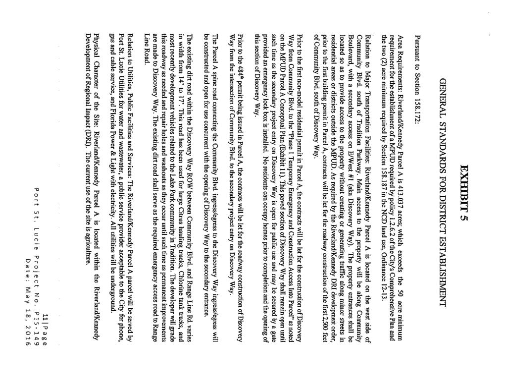
21
22
23
24
25
26

27
28
29
30
31

32
33
34
35
36 LAKEPARK AT TRADITION - PLAT 1 P.B. 70, PG. 35 TRADITION PLAT NO TOWNPARK PHASE ONE P.B. 47, PG. 32 SOUTHERN GROVE PLAT NO. 4 P.B. 56, PG. 18 SOUTHERN GROVE PLAT NO. 4 P.B. 56, PG. 18 EMERGENCY ACCESS TO RANGE LINE ROAD VIA EXISTING DIRT ROAD DISCOVERY WAY (E/W 1) LEGEND LAKE LAKE Phase 2 LAKE RESIDENTIAL TRACT 1 LAKE LAKE RESIDENTIAL TRACT 1 ( AC) MAXIMUM 1,100 UNITS RIVERLAND/KENNEDY FUTURE PARCEL C (N/S B) LAKE LAKE LAKE RESIDENTIAL TRACT 1 LAKE Phase 1 LAKE LAKE LAKE LAKE LAKE LAKE LAKE LAKE COMMUNITY BLVD MULTI-MODAL OPEN SPACE (INCLUDES 25' MULTI- MODAL PUBLIC ACCESS EASEMENT) TRACT 2 ( AC) PEDESTRIAN + GOLF CART CONNECTION TO MULTI-MODAL OPEN SPACE (LOCATIONS CONCEPTUAL) LAKE LAKE 150' R/W RIVERLAND/KENNEDY FUTURE PARCEL B NOTES: 1. THE STORMWATER MANAGEMENT SYSTEM FOR PARCEL A OF RIVERLAND/KENNEDY DRI SHALL BE DESIGNED TO TREAT AND CONVEY THE STORMWATER FROM THE ULTIMATE SECTION FOR THE ADJACENT ROADWAYS OF COMMUNITY BOULEVARD, N/S B AND DISCOVERY WAY, AND APPROPRIATE FLOWAGE EASEMENTS WILL BE PROVIDED TO THE CITY " = 500' 1600 Sawgrass Corporate Pkwy. - Suite 400 Sunrise, Florida N.T.S FPG GD Exhibit-11 RIVERLAND MPUD - PARCEL A Port St. Lucie, Florida EXHIBIT - 11 CONCEPTUAL PLAN EXH-11 \\glhomes\network\data\architecture\landscape Architecture\Riverland\Riverland MP\EXHIBITS\ \RL - Conceptual Plan Exhibit - Parcel A.dwg
37
38
39 LEGEND PROPOSED RIGHT OF WAY UTILITY EASEMENT (U.E.) CENTERLINE OF CONSTRUCTION PROPOSED SIDEWALK (SW) PROPOSED TRAVEL LANE NOTES: 1. STREET TREES MAY BE INSTALLED IN ACCORDANCE WITH SECTION OF THE CITY OF PORT ST. LUCIE CODE OF ORDINANCES. 2. TREES SHALL BE ADJUSTED PER DRIVEWAY LOCATIONS WITH A MINIMUM 5' TO THE DRIVEWAY 3. FOR LOOPING PURPOSES, A SECOND WATER MAIN MAY BE INSTALLED UNDER THE ROADWAY OR IN PLACE OF THE STREET TREES AS APPROVED BY THE PORT ST. LUCIE UTILITY SYSTEMS DEPARTMENT. 4. STREET LIGHT STYLE, HEIGHT, AND SPACING SHALL BE ADJUSTED TO MEET PSL AND FPL LIGHTING STANDARDS. 5. STREET TREES AND LIGHTS WILL MEET FDOT CLEAR ZONE AND SIGHT DISTANCE REQUIREMENTS. REFER TO EXHIBIT 17 OF MPUD FOR APPROVED STREET TREE LIST. 6. POSTED SPEED LIMIT: 25 MPH 7. PRIVATE ROADWAY OWNED AND MAINTAINED BY A PRIVATE ENTITY AND NOT THE CITY OF PORT ST. LUCIE. LOCATION OF SIDEWALKS MAY VARY. FINAL LOCATION OF UTILITIES MAY BE ADJUSTED FOR SPECIFIC CONDITION 1600 Sawgrass Corporate Pkwy. - Suite 400 Sunrise, Florida N.T.S Exhibit-13A FPG GD RESIDENTIAL LOCAL 2-LANE ROADWAY - 50' ROW TYPICAL SECTION N.T.S. RIVERLAND MPUD - PARCEL A Port St. Lucie, Florida EXHIBIT - 13A TYPICAL ROADWAY SECTION - 50' RIGHT-OF-WAY * SIDEWALK SHALL BE ON ONE SIDE OF THE ROADWAY EXH-13A
40 LEGEND PROPOSED RIGHT OF WAY UTILITY EASEMENT (U.E.) CENTERLINE OF CONSTRUCTION PROPOSED SIDEWALK (SW) PROPOSED TRAVEL LANE NOTES: 1. STREET TREES MAY BE INSTALLED IN ACCORDANCE WITH SECTION OF THE CITY OF PORT ST. LUCIE CODE OF ORDINANCES. 2. IN LIEU OF TWO 5' SIDEWALKS, ONE 8' PATH MAY BE SUBSTITUTED. AS APPROVED BY THE PORT ST. LUCIE UTILITY SYSTEMS DEPARTMENT. 3. STREET LIGHT STYLE, HEIGHT, AND SPACING SHALL BE ADJUSTED TO MEET PSL AND FPL LIGHTING STANDARDS. 4. STREET TREES AND LIGHTS WILL MEET FDOT CLEAR ZONE AND SIGHT DISTANCE REQUIREMENTS. REFER TO EXHIBIT 17 OF MPUD FOR APPROVED STREET TREE LIST. 5. POSTED SPEED LIMIT: 25 MPH 6. PRIVATE ROADWAY OWNED AND MAINTAINED BY A PRIVATE ENTITY AND NOT THE CITY OF PORT ST. LUCIE. LOCATION OF SIDEWALKS MAY VARY. FINAL LOCATION OF UTILITIES MAY BE ADJUSTED FOR SPECIFIC CONDITION RESIDENTIAL LOCAL 2-LANE ROADWAY - 80' ROW TYPICAL SECTION N.T.S Sawgrass Corporate Pkwy. - Suite 400 Sunrise, Florida " = 10' FPG GD Exhibit-13B RIVERLAND MPUD - PARCEL A Port St. Lucie, Florida EXHIBIT - 13B TYPICAL ROADWAY SECTION - 80' RIGHT-OF-WAY EXH-13B
41 DISCOVERY WAY (E/W 1) Phase 2 RESIDENTIAL TRACT 1 Phase 1 RIVERLAND/KENNEDY FUTURE PARCEL C (N/S B) RESIDENTIAL TRACT 1 COMMUNITY BLVD RIVERLAND/KENNEDY FUTURE PARCEL B " = 500' 1600 Sawgrass Corporate Pkwy. - Suite 400 Sunrise, Florida " = 10' FPG GD Exhibit-14 RIVERLAND MPUD - PARCEL A Port St. Lucie, Florida EXHIBIT - 14 WATER/SEWER PLAN EXH-14 \\glhomes\network\data\architecture\landscape Architecture\Riverland\Riverland MP\EXHIBITS\ \RL - Conceptual Plan Exhibit -
42
43
44
The Conservatory Commercial
 The Conservatory Commercial Northeast Florida 16.25± AC AVAILABLE N Old Kings Rd The Conservatory Golf Course Matanzas Woods Pkwy Palm Harbor Pkwy Coming Soon: Senior Living Facility 100 Beds Matanzas
FINAL. Bicycle/Pedestrian Feasibility Study City of DeBary Dirksen Drive Trail. Prepared For: Volusia County MPO
 City of DeBary Dirksen Drive Trail FINAL Prepared By: Reynolds, Smith and Hills, Inc. Prepared For: Volusia County MPO September 2007 Table of Contents INTRODUCTION...1 PROJECT PURPOSE AND SCOPE...2 PHYSICAL
MUSCATINE COUNTY BOARD OF SUPERVISORS
 MUSCATINE COUNTY BOARD OF SUPERVISORS Robert Howard, District One Matt Bonebrake, District Two Scott Sauer, District Three Nathan Mather, District Four Jeff Sorensen, District Five AGENDA 9:00 a.m. 1.
ORDINANCE NO WHEREAS, Marina District Development, LLC is the fee simple owner of the following described real estate, to wit:
 SPONSOR: Councilman Kalwinski PETITIONED BY: Marina District Development, LLC ORDINANCE NO. 9304 AN ORDINANCE VACATING A 859 FOOT PORTION OF 5 th AVENUE, MORE OR LESS, LYING BETWEEN 112 th STREET INDIANAPOLIS
FISCHLER PROPERTY COMPANY LLC 1605 HENDRY STREET FORT MYERS, FL
 FISCHLER PROPERTY COMPANY LLC 1605 HENDRY STREET FORT MYERS, FL 33901 WWW.FISCHLERCO.COM FOR SALE 1013 EMBERS PKWY., CAPE CORAL, FL 33993 ENTITLED LAND FOR DEVELOPMENT EMBERS LAKE ESTATES for information
Longmont to Boulder Regional Trail Jay Road Connection DRAFT FINAL REPORT
 Longmont to Boulder Regional Trail Jay Road Connection DRAFT FINAL REPORT December 2018 Project Summary Boulder County, Colorado, in partnership with the City of Boulder, is evaluating options for multi-use
FDOT Treasure Coast Traffic Impact Report
 July 22, 2016 Chuck McGinness, 954-777-4302 chuck.mcginness@dot.state.fl.us FDOT Treasure Coast Traffic Impact Report July 22 through July 29, 2016 TREASURE COAST Construction and maintenance-related lane
City of Port St. Lucie Planning and Zoning Department ALL DATES ARE TENTATIVE AND SUBJECT TO CHANGE SCHEDULES FOR 2018
 Planning and Zoning Department ALL DATES ARE TENTATIVE AND SUBJECT TO CHANGE SCHEDULES FOR NOTE: DELIVERY DEADLINE ON ALL SUBMITTALS, INCLUDING ONLINE, IS 12:00 NOON ALL DRAWINGS SUBMITTED MUST BE BLACKLINE,
Trail Feasibility Study
 VOLUSIA COUNTY MPO CITY OF NEW SMYRNA BEACH FINAL REPORT JUNE 30, 2009 Trail Feasibility Study What s inside? 1 Introduction 2 Project Purpose & Scope 3 Physical Inventory & Assessment of Right-of- Way
FY Candidate Sidewalk Projects. Sidewalk Advisory Committee
 FY 18-19 Candidate Sidewalk Projects Sidewalk Advisory Committee Sidewalk Advisory Committee December 2017 FY 18-19 Candidate Sidewalk Projects Old Berkley Road C. Fred Jones Blvd. (CR 559A) to Gapway
PROPERTY FEATURES PRICE: CALL FOR DETAILS AVAILABLE: 1,000-34,000± SF LOCATION:
 FOR LEASE SEQ IMMOKALEE RD & SR 951 THE is a premium retail center located in one of biggest growth areas in all of Naples, Florida. Surrounded by lots of new residential & commerical development, this
CITY OF MARGATE TRANSPORTATION ELEMENT
 CITY OF MARGATE TRANSPORTATION ELEMENT Revised: August 2004 TABLE OF CONTENTS Page No. INTRODUCTION DESCRIPTION OF EXISTING TRANSPORTATION SYSTEM Roadway System Significant Parking Facilities Public Transit
Culpeper District. Albemarle County Monthly Report December 2011
 Culpeper District Albemarle County Monthly Report Special Issues Construction Significant Accomplishments (as of 11/15/11) Georgetown Road completed on November 8. I-64 Eastbound Shadwell Exit completed
EXCELLENT DEVELOPMENT OPPORTUNITY
 1.2 ACRES TO 14 ACRES AVAILABLEAILABLE SW CORNER OF NORMANDY BLVD. AT NORMANDY VILLAGE PKWY., JACKSONVILLE, FL 32221 For More Information: 904.239.5269 mclark@primerealtyinc.com 904.930.4299 akay@primerealtyinc.com
FDOT Treasure Coast Traffic Impact Report October 9 through October 16, 2015
 From: Kathleen Dempsey To: Kathleen Dempsey Subject: FDOT Treasure Coast Traffic Report 10 09 15 through 10 16 15 Date: Friday, October 09, 2015 2:10:36 PM Attachments: image003.png CR 714_Median Construction
Welcome to the Downtown Fort Lauderdale Neighborhood Working Group Meeting. First meeting june 17, 2010
 Welcome to the Downtown Fort Lauderdale Neighborhood Working Group Meeting First meeting june 17, 2010 State of the Project Draft Environmental Impact Statement Study Phase This study is NOT the final
Northeast Florida Regional Council. Saratoga Springs Presentation September 7, 2006
 Northeast Florida Regional Council Saratoga Springs Presentation September 7, 2006 Location Clay County, Florida SARATOGA SPRINGS 2 LandMar Founded in 1987 by Edward Burr, CEO Became an affiliate of Crescent
Memo. Orange City Trail Plan Becky Mendez, AICP Jamie Krzeminski, PE, PTOE Matt Wiesenfeld, PE, AICP. Development of the Existing and Proposed Network
 Memo Date: Friday, December 22, 2017 Project: To: From: Subject: Trail Plan Becky Mendez, AICP Jamie Krzeminski, PE, PTOE Matt Wiesenfeld, PE, AICP Development of the Existing and Proposed Network HDR
AGENDA ITEM 5 D WAKULLA ENVIRONMENTAL INSTITUTE (WEI) TRAIL FEASIBILITY STUDY
 TRAIL FEASIBILITY STUDY") March 19, 2018 AGENDA ITEM 5 D WAKULLA ENVIRONMENTAL INSTITUTE (WEI) TRAIL FEASIBILITY STUDY TYPE OF ITEM: Action STATEMENT OF ISSUE The Wakulla Environmental Institute (WEI) Trail is one of several trails
March 19, 2018 AGENDA ITEM 5 D WAKULLA ENVIRONMENTAL INSTITUTE (WEI) TRAIL FEASIBILITY STUDY TYPE OF ITEM: Action STATEMENT OF ISSUE The Wakulla Environmental Institute (WEI) Trail is one of several trails
LENDER OWNED ±6.8 ACRES IN GRIFFITH COMMERCE PARK EXCLUSIVE LISTING NEC 107TH AVENUE & VAN BUREN STREET, AVONDALE, ARIZONA
 Central Ave El Mirage Rd 107th Ave LENDER OWNED ±6.8 ACRES IN GRIFFITH COMMERCE PARK EXCLUSIVE LISTING NEC 107TH AVENUE & VAN BUREN STREET, AVONDALE, ARIZONA Litchfield Litchfield gwam Blvd Sunrise Palm
14.1.a. Attachment: Engineering Standards Manual Draft (2016 : Approval of the Engineering Standards Manual) Packet Pg. 216
 Packet Pg. 216") Packet Pg. 216 City of Fort Walton Beach Manual November 2012 14.1.a City of Fort Walton Beach Manual TABLE OF CONTE SECTION 1.00 INTRODUCTION... 3 SECTION 2.00 POLICY... 3 SECTION 3.00 - EROSION AND SEDIMENTATION
Packet Pg. 216 City of Fort Walton Beach Manual November 2012 14.1.a City of Fort Walton Beach Manual TABLE OF CONTE SECTION 1.00 INTRODUCTION... 3 SECTION 2.00 POLICY... 3 SECTION 3.00 - EROSION AND SEDIMENTATION
List of Lands Available for Taxes
 List of ****Florida Statute 197.502 Application for obtaining tax deed by holder of tax sale certificate; fees. (7) On county-held or individually held certificates for which there are no bidders at the
ANCLOTE COASTAL TRAIL ALTERNATIVES ANALYSIS STUDY
 ANCLOTE COASTAL TRAIL ALTERNATIVES ANALYSIS STUDY PASCO COUNTY MPO JULY 2015 PROJECT OVERVIEW... INTRODUCTION EXECUTIVE SUMMARY CONTEXT... TAMPA BAY AREA, PINELLAS, & PASCO COUNTY S MULTI-USE TRAIL PLANS
AND AND ALL OF SAID LANDS SITUATE, LYING AND BEING IN THE CITY OF HOLLYWOOD, BROWARD COUNTY, FLORIDA, CONTAINING 326,439 SQUARE FEET ( ACRES).
.") PROPOSED DEALERSHIP AND FOR: 11 NORTH STATE ROAD, FLORIDA. 3301 INDEX OF DRAWINGS ARCHITECTURAL A-0 COVER SHEET SHEET 1 OF BOUNDARY AND TOPOGRAPHIC SURVEY SHEET OF BOUNDARY AND TOPOGRAPHIC SURVEY A-1.1
PROPOSED DEALERSHIP AND FOR: 11 NORTH STATE ROAD, FLORIDA. 3301 INDEX OF DRAWINGS ARCHITECTURAL A-0 COVER SHEET SHEET 1 OF BOUNDARY AND TOPOGRAPHIC SURVEY SHEET OF BOUNDARY AND TOPOGRAPHIC SURVEY A-1.1
4. Safety Concerns Potential Short and Medium-Term Improvements
 NH Route 104 Access Management Study Page 19 4. Safety Concerns Potential Short and Medium-Term Improvements Potential safety improvement strategies are listed by priority based on field observations by
FDOT Treasure Coast Traffic Impact Report March 25 through April 1, 2016
 March 25, 2016 Chuck McGinness, 954-777-4302 chuck.mcginness@dot.state.fl.us FDOT Treasure Coast Traffic Impact Report March 25 through April 1, 2016 TREASURE COAST Construction and maintenance-related
What is Shovel Ready Palm Beach? What is a Shovel Ready Site?
 What is Shovel Ready Palm Beach? Shovel Ready Palm Beach is one of the first programs of its kind in Florida. Under the program, the BDB identifies vacant commercial and industrial property that is Shovel
N Mar m wd v. Heritage Harbor Phase 2A and 3A CORRECTED 2/2/2001
 Subdivision /Condominium Owner U S Home Corporation Beginning Parcel No. 12928.0900 Address Zip Code Ste 600 311 Park Place Blvd Clearwater FL 33759 T.D. Plat Bk-Pg S-T-R Prev Folio No. Yr Sold Sale Price
City of Madison, Buckeye Road Monona Drive to Stoughton Road County AB Dane County Public Involvement Meeting
 City of Madison, Buckeye Road Monona Drive to Stoughton Road County AB Dane County Public Involvement Meeting Wednesday, May 31, 2017 6:30 to 8 P.M. Frank Allis Elementary School 4201 Buckeye Road Madison,
Completion: August 2011 LS #321 Design LS #8
 1 CIPNumber c350406 2 c350302 3 c350902 LEGEND PERMITTING/ BIDDING CHARLOTTE COUNTY UTILITIES Burnt Store Water Reclamation Facility (Expansion to 0.75 MGD) East Port Expansion Water Reclamation Facility
Northaven Trail Phase 2 Initial Project Overview
 Northaven Trail Phase 2 Initial Project Overview Partnership Project to extend existing Northaven Trail Improve Bike/Ped Connectivity On Dallas Trail Network Plan City and County Funding Oncor Texas Trails
Quiet Zone along FEC Corridor. Paul Calvaresi Regional Transportation Planner
 Quiet Zone along FEC Corridor Paul Calvaresi Regional Transportation Planner Calvaresip@browardmpo.org About the Quiet Zone Throughout all of Broward County on the FEC Tracks Deerfield Beach Pompano Beach
OPPORTUNITY PRESENTED BY
 IDEAL CORPORATE HEADQUARTERS FOR SALE OR LEASE 1860 SW FOUNTAINVIEW BLVD PORT ST. LUCIE, FL OPPORTUNITY PRESENTED BY Thomas R. 3710 Gibson, Buckeye Broker Street Suite 561.776.9300 100 Palm Beach trg@assetspecialists.com
DEVELOPMENT PLAN REVIEW PROCESS and APPLICANT GUIDELINES
 DEVELOPMENT PLAN REVIEW PROCESS and APPLICANT GUIDELINES DEVELOPMENT DEPARTMENT 120 Gary Wade Boulevard Sevierville, TN 37862 (865) 453-5504 seviervilletn.org Pamela S. Caskie, Development Director Judith
NEW MEADOWS PARK PROPOSED MASTER PLAN
 NEW MEADOWS PARK PROPOSED MASTER PLAN A vision for your neighborhood park, the draft master plan is ready for your review. Tuesday September 12 th, 2017 5:30-7:00 PM Hellgate School District #4 middle
FDOT Treasure Coast Traffic Report through
 FDOT Treasure Coast Traffic Report 02 26 16 through 03 04 16 Kathleen Dempsey Fri 2/26/2016 2:56 PM To:Kathleen Dempsey ; 1 attachment 355 KB CR 714_Median Access Modifications.pdf;
Header i
 Header i 048285014.10 Header Sub Title Body Text here. Body text here. Body text here. Section 1... 1 Executive Summary... 1 Opportunities and Constraints... 3 Overall Opportunities and Constraints Map
The Joint Charlotte County - Punta Gorda and Lee MPO Meeting has changed from 10:00 a.m. to 9:30 a.m.
 The Joint Charlotte County - Punta Gorda and Lee MPO Meeting has changed from 10:00 a.m. to 9:30 a.m. JOINT MEETING OF THE CHARLOTTE COUNTY-PUNTA GORDA METROPOLITAN PLANNING ORGANIZATION BOARD AND LEE
Lee County Board of County Commissioners January 24, 2017 Workshop Meeting
 Lee County Board of County Commissioners January 4, 017 Workshop Meeting 1 Review Current Transportation Priorities (Tiers 1,, 3) Discuss Status of Projects 3 Discuss Ranking Recommendations 1 State of
FOR SALE OR LEASE. St. Croix Meadows Redevelopment LOTS FOR SALE. Hudson, WI
 St. Croix Meadows Redevelopment EXIT RAMP EXISTING OVERPASS VACATE R.O.W. CARMICHAEL RD ON RAMP HIGH-TECH/FLEX SPACE MEDICAL OFFICE - 20K SF EACH RETAIL / ENTERTAINMENT 24-46K SF FULL ACCESS CORPORATE
Macleod Trail Corridor Study. Welcome. Macleod Trail Corridor Study Open House. Presentation of Proposed Design Concepts
 Macleod Trail Corridor Study Welcome Macleod Trail Corridor Study Open House Presentation of Proposed Design Concepts Study Purpose Develop a corridor plan for Macleod Trail that aligns with The City s:
CITY OF PORT ORANGE MONTHLY DEVELOPMENT ACTIVITY REPORT
 CITY OF PORT ORANGE MONTHLY DEVELOPMENT ACTIVITY REPORT Walmart Neighborhood Market 3811 Clyde Morris Blvd. CITY COUNCIL allen green, mayor drew bastian, vice mayor bob ford, councilman donald burnette,
OFFICE OF THE PLANNING COMMISSION City Hall Holland, Michigan
 OFFICE OF THE PLANNING COMMISSION City Hall Holland, Michigan Planning Commission Report Report 4 To: Mayor DeBoer and Members of the Holland City Council Date: May 25, 2016 Subject: 11th Street Rezoning
FDOT Treasure Coast Traffic Impact Report June 19 through June 26, 2015
 June 19, 2015 Chuck McGinness, 954-777-4302 chuck.mcginness@dot.state.fl.us FDOT Treasure Coast Traffic Impact Report June 19 through June 26, 2015 TREASURE COAST Construction and maintenance-related lane
2017 FTBA CONSTRUCTION CONFERENCE February 2-3, 2017 Hyatt Regency, Orlando FDOT WORK PROGRAM OVERVIEW
 Florida Department of TRANSPORTATION 2017 FTBA CONSTRUCTION CONFERENCE February 2-3, 2017 Hyatt Regency, Orlando FDOT WORK PROGRAM OVERVIEW Presenter: Jim Boxold, Secretary 1 Florida s Continued Growth
CHAPTER FIVE ENVIRONMENTAL CONSEQUENCES
 CHAPTER FIVE ENVIRONMENTAL CONSEQUENCES Pursuant to the environmental documentation requirements of FAA Order 1050.1E, Environmental Impacts, Policies and Procedures, this chapter describes the reasonably
November 21, 2012 Barbara Kelleher, (954)
") November 21, 2012 Barbara Kelleher, (954) 777-4090 barbara.kelleher@dot.state.fl.us BROWARD COUNTY TRAFFIC IMPACT REPORT November 26 to November 30, 2012 FORT LAUDERDALE -- Construction and maintenance-related
November 21, 2012 Barbara Kelleher, (954) 777-4090 barbara.kelleher@dot.state.fl.us BROWARD COUNTY TRAFFIC IMPACT REPORT November 26 to November 30, 2012 FORT LAUDERDALE -- Construction and maintenance-related
Abbott Rd Rehabilitation Phase II - Elmore Rd to Birch Rd
 Abbott Rd Rehabilitation Phase II - Elmore Rd to Birch Rd Project ID SOA07003 Department State of Alaska Project Type Improvement Start Date December 2017 Location Assembly: Section 4, Seats F & G, Assembly:
MATTHEW G. MCALLISTER Director (561)
") SOUTH FLORIDA INDUSTRIAL TEAM CUSHMAN & WAKEFIELD AVAILABLE PROPERTIES February 2017 CUSHMAN & WAKEFIELD 515 E. Las Olas Boulevard, Suite 860 Fort Lauderdale, FL 33301 225 NE Mizner Boulevard, Suite 300
SOUTH FLORIDA INDUSTRIAL TEAM CUSHMAN & WAKEFIELD AVAILABLE PROPERTIES February 2017 CUSHMAN & WAKEFIELD 515 E. Las Olas Boulevard, Suite 860 Fort Lauderdale, FL 33301 225 NE Mizner Boulevard, Suite 300
MINUTES OF THE SPECIAL MEETING OF THE LADY LAKE TOWN COMMISSION LADY LAKE, FLORIDA September 17, 2013
 MINUTES OF THE SPECIAL MEETING OF THE LADY LAKE TOWN COMMISSION LADY LAKE, FLORIDA The Special Meeting of the Lady Lake Town Commission was held in the Commission Chambers at Lady Lake Town Hall, 409 Fennell
NDOT MAJOR PROJECTS AND INNOVATIVE DELIVERY 2017 NEVADA TRANSPORTATION CONFERENCE COLE MORTENSEN, PE ASST. CHIEF OF PROJECT MANAGEMENT
 NDOT MAJOR PROJECTS AND INNOVATIVE DELIVERY 2017 NEVADA TRANSPORTATION CONFERENCE COLE MORTENSEN, PE ASST. CHIEF OF PROJECT MANAGEMENT PM DIVISION RESPONSIBILITIES FHWA MAJOR PROJECTS TOTAL PROJECT COST
Interoffice Memorandum
 Supplemental Information Agenda Item No. 5.1 May 1, 2014 Interoffice Memorandum May 1, 2014... Date Honorable Planning Commission... To Rick Carter, PE... From Agenda Item 5.1-2014-2019 Capital Improvement
PELICAN LANDING RAPTOR BAY REZONING TRANSPORTATION METHODOLOGY OUTLINE
 PELICAN LANDING RAPTOR BAY REZONING TRANSPORTATION METHODOLOGY OUTLINE Project No. 15534 Prepared by: DAVID PLUMMER & ASSOCIATES, INC. 2149 McGregor Boulevard June 24, 2016 Fort Myers, Florida 33901 Pelican
LAKE MOUNTAIN PRELIMINARY
 VICINITY MAP VICINITY MAP PREPARED FOR:. THE EXISTENCE AND LOCATION OF ANY UNDERGROUND UTILITY PIPES, CONDUITS OR STRUCTURES SHOWN ON THESE S WERE OBTAINED BY A SEARCH OF THE AVAILABLE RECORDS, TO THE
Blueways: Rivers, lakes, or streams with public access for recreation that includes fishing, nature observation, and opportunities for boating.
 Parks, Open Space and Trails PRINCE WILLIAM COUNTY 2008 COMPREHENSIVE PLAN TRAILS PLAN CONTENTS The components of the trails plan are: Intent Definitions Goals, Policies, and Action Strategies Trails Map
- AGENDA - January 30, :00 P.M. 329 Main Street (Meeting Room - Basement)
") CLARKSVILLE-MONTGOMERY COUNTY REGIONAL PLANNING COMMISSION - AGENDA - January 30, 2019 2:00 P.M. 329 Main Street (Meeting Room - Basement) I. CALL TO ORDER/QUORUM CHECK/PLEDGE TO FLAG II. APPROVAL OF MINUTES
CLARKSVILLE-MONTGOMERY COUNTY REGIONAL PLANNING COMMISSION - AGENDA - January 30, 2019 2:00 P.M. 329 Main Street (Meeting Room - Basement) I. CALL TO ORDER/QUORUM CHECK/PLEDGE TO FLAG II. APPROVAL OF MINUTES
A DIALOGUE WITH THE NORTHERN VIRGINIA DISTRICT. Nicholas J. Roper, P.E. Northern Virginia District Project Development Engineer
 A DIALOGUE WITH THE NORTHERN VIRGINIA DISTRICT Nicholas J. Roper, P.E. Northern Virginia District Project Development Engineer Agenda Dashboard 2019 Project Advertisements for Construction 2019 New Projects
SR 429/WEKIVA PARKWAY FTBA CONFERENCE March 20-21, Presented By Suzanne Phillips, P.E., FDOT District 5
 SR 429/WEKIVA PARKWAY FTBA CONFERENCE March 20-21, 2012 Presented By Suzanne Phillips, P.E., FDOT District 5 Project Description The Wekiva Parkway project constructs 25 centerline miles of new toll expressway.
PUBLIC INFORMATION SESSION #2
 Highway 16, Highway 779 to Kapasiwin Road, Planning Study PUBLIC INFORMATION SESSION #2 Wednesday June 20, 2012 4 to 8 pm HIGHWAY 16 Highway 779 to Kapasiwin Road Functional Planning Study Blueberry Community
Dover Park Master Plan. Community Design Event Tuesday, May 22, 5 7 pm
 Dover Park Master Plan Community Design Event Tuesday, May 22, 5 7 pm Agenda I. Introduction / Overview 20 minutes II. Small Group Design Activity 60 minutes III. Small Group Report Out IV. Conclusion
COMMENT PERIOD INTRODUCTION
 To: Interested Persons From: Tom Buford File: Del Rio Trail Project Date: June 8, 2018 Community Development Department Reference: NOTICE OF PREPARATION OF AN ENVIRONMENTAL IMPACT REPORT FOR THE DEL RIO
Coast to Coast Connector Summit
 Project Partners Welcome to the Coast to Coast Connector Summit Winter Garden, Florida City Hall October 1, 2014 1 Why are we here? Objectives 1. Inform key stakeholders on the current state of the C2C
Memorandum / Letter of Intent
 VERONA WAUKESHA KENOSHA APPLETON WESTON Memorandum / Letter of Intent To: Adam Sayre, Director of Planning & Development, City of Verona From: Kevin Yeska, JSD Professional Services, Inc. www.jsdinc.com
DEVELOPMENT REVIEW COMMITTEE, PASCO COUNTY, FLORIDA MINUTES
 DEVELOPMENT REVIEW COMMITTEE, PASCO COUNTY, FLORIDA MINUTES THE MINUTES WERE PREPARED IN AGENDA ORDER AS PUBLISHED AND NOT IN THE ORDER THE ITEMS WERE HEARD AUGUST 28, 2008 1:30 P.M. West Pasco Government
Call for Lease Pricing
 NEW CONSTRUCTION Douglas R. Legler Broker Associate +1 772 405 7778 douglas@naisouthcoast.com www.naisouthcoast.com Call for Lease Pricing 65 Single Family Lots Property Information Property Details Address:
Site Location and Setting
 Memorandum Date: To: From: Subject: Kristy Le, Gary Black Steve Orem Santa Teresa County Park Historic Area Traffic and Parking Study Hexagon Transportation Consultants, Inc. has completed a traffic and
Pattullo Bridge Replacement Project
 JULY 2018 PROJECT OVERVIEW Pattullo Bridge Replacement Project engage.gov.bc.ca/pattullobridge Artist s rendering of the proposed new Pattullo Bridge Pattullo Bridge Replacement Project 1 Priority Need
FDOT Treasure Coast Traffic Impact Report
 July 7, 2017 Chuck McGinness, 954 777 4302 chuck.mcginness@dot.state.fl.us FDOT Treasure Coast Traffic Impact Report July 7 through July 14, 2017 TREASURE COAST Construction and maintenance related lane
CITY OF PORT ORANGE MONTHLY DEVELOPMENT ACTIVITY REPORT
 CITY OF PORT ORANGE MONTHLY DEVELOPMENT ACTIVITY REPORT Hawks Preserve Subdivision CITY COUNCIL allen green, mayor drew bastian, vice mayor bob ford, councilman donald burnette, councilman scott stiltner,
Public Open House. Chief Peguis Trail Project
 Public Open House Chief Peguis Trail Project CHIEF PEGUIS TRAIL OPEN HOUSE Welcome! Please browse the display boards Project Engineers and City of Winnipeg representatives are available to address your
AUGUST 5, 2010 UPDATE # 3 AMTRAK/FEC PROJECT: STATION LOCATIONS AND CONCEPTUAL DRAWINGS
 AUGUST 5, 2010 UPDATE # 3 AMTRAK/FEC PROJECT: STATION LOCATIONS AND CONCEPTUAL DRAWINGS The Summer of 2010 has been a time of tremendous progress for the Amtrak/FEC Corridor project and its goal of restoring
Report to the Strategic Development Committee
 Report to the Strategic Development Committee Recommendation to Approve the Request of Virginia Department of Transportation for Easements across Washington Dulles International Airport Property at Route
MINUTES COMMUNITY DEVELOPMENT BOARD MARCH 18, 2015 AT 6:00 P.M. CITY HALL, 116 FIRST STREET NEPTUNE BEACH, FLORIDA
 MINUTES COMMUNITY DEVELOPMENT BOARD MARCH 18, 2015 AT 6:00 P.M. CITY HALL, 116 FIRST STREET NEPTUNE BEACH, FLORIDA Pursuant to proper notice a public hearing of the Community Development Board for the
City of Redding Airports
 City of Redding Airports Benton Airpark Redding Municipal Airport DEVELOPMENT AND USE GUIDELINES FOR GENERAL AVIATION HANGARS April 7, 2009 PREFACE The City of Redding, as owner of federally obligated
SR 934 Project Development And Environment (PD&E) Study
 Study") SR 934 Project Development And Environment (PD&E) Study Project Advisory Group Meeting March 1, 2018 State Road 934/NE/NW 79th Street from west of I-95 (NW 13th CT) to N. Bayshore Drive PD&E STUDY SR 934/NE/NW
SR 934 Project Development And Environment (PD&E) Study Project Advisory Group Meeting March 1, 2018 State Road 934/NE/NW 79th Street from west of I-95 (NW 13th CT) to N. Bayshore Drive PD&E STUDY SR 934/NE/NW
Broward County Land Use Plan: Environmentally Sensitive Lands
 US27 HIATUS RD NW 136TH AVE SW 136TH AVE FLAMINGO RD LYONS RD CYPRESS RD Broward County Land Use Plan: Environmentally Sensitive Lands PALM BEACH COUNTY N USHY 27 284939 334939 045039 095039 44 CONSERVATION
INDUSTRIAL / BUSINESS PARK OPPORTUNITY
 INDUSTRIAL / BUSINESS PARK OPPORTUNITY FORT MYERS, FLORIDA WHAT S INSIDE: Development Location Page 1 Opportunity Details Page 2 Development Overview Page 3 Surrounding Area Pages 4-5 Additional Information
Former Middle School Site Green Space & Brecksville Road Streetscape. March 27, 2018
 Former Middle School Site Green Space & Brecksville Road Streetscape March 27, 2018 Brecksville Streetscape & Downtown Greenspace Project Schedule City of Indepenence 2017 2018 Meeting Schedule Tasks/Deliverables
 SURVEYOR'S CERTIFICATE RIVERFRONT MASTER PLANNED MIXED USE DISTRICT PHASE 3 SUBDIVISION PLAT I, SATTAR N. TABRIZ, DO HEREBY CERTIFY THAT I AM A PROFESSIONAL LAND SURVEYOR LICENSED TO PRACTICE IN THE STATE
Buchanan Field. Airport Planning Program. Steering Committee. December 14, Master Plan FAR Part 150 Noise Study Strategic Business Plan
 Airport Planning Program Master Plan FAR Part 150 Noise Study Strategic Business Plan Steering Committee December 14, 2006 Airport Planning Program Master Plan FAR Part 150 Noise Study Strategic Business
±15.01 Acres, H-2 Zoned SEC Las Vegas Blvd & Chartan Ave / Las Vegas, NV 89183
 Las Vegas Strip Property Highlights South Point Hotel & Casino Developers dream location for a hospitality; apartment or commercial tourist development Hard to find contiguous acreage in the path of development
LAND FOR SALE. LAKE COUNTY PLANNED TOWN CENTER MIXED USE LAKEFRONT 721± acres Lake County, FL INCREDIBLE LOCATION SIZE FRONTAGE
 centrally LOCATED! Minutes from WALT DISNEY WORLD! Lake Louisa INCREDIBLE LOCATION Located on east side of US 27 approx. 2 miles south of Clermont in Lake County, FL. SIZE 721± acres Seller will divide.
 Planning Division Case Report SE16-0015 Review Date: March 14, 2017 Property Owner: Cape Investments Overseas Corporation, Inc. Owner Address: Freigutstr 24, PO Box 220 8027 Zurich, Switzerland Applicant:
Major Projects Overview
 Major Projects Overview Miami-Dade Expressway Authority February 2018 About MDX MDX operates 5 roads in Miami Dade County SR 924, SR 112, SR 836, SR 874 and SR 878 MDX Primary Source of Revenue: User Fees-Tolls
CATARACT CREEK ESTATES
 CATARACT CREEK ESTATES EXCLUSIVE LISTING WILLIAMS, ARIZONA LOCATION NWC of Airport Road and Lake Ellen Way, Williams, Arizona SIZE ±38.95 acres LOT DESCRIPTION 55 P&E Single Family Lots (7,000 sq. ft.)
CITY OF PORT ORANGE MONTHLY DEVELOPMENT ACTIVITY REPORT
 CITY OF PORT ORANGE MONTHLY DEVELOPMENT ACTIVITY REPORT VyStar Credit Union 750 Dunlawton Ave. CITY COUNCIL allen green, mayor drew bastian, vice mayor bob ford, councilman donald burnette, councilman
Lake Erie Commerce Center Traffic Analysis
 LOCATION: East of NYS Route 5 at Bayview Road Town of Hamburg Erie County, New York PREPARED BY: Wendel Companies 140 John James Audubon Parkway Suite 200 Amherst, New York 14228 January 2012 i ii Table
Northeast Quadrant Distinctive Features
 NORTHEAST QUADRANT Northeast Quadrant Distinctive Features LAND USE The Northeast Quadrant includes all the area within the planning area that is east of Interstate 5 and to the north of State Route 44.
CITY OF PORT ORANGE MONTHLY DEVELOPMENT ACTIVITY REPORT
 CITY OF PORT ORANGE MONTHLY DEVELOPMENT ACTIVITY REPORT VyStar Credit Union 750 Dunlawton Ave. CITY COUNCIL allen green, mayor drew bastian, vice mayor bob ford, councilman donald burnette, councilman
INTER-OFFICE MEMORANDUM
 INTER-OFFICE MEMORANDUM TO: FROM: Development Review Committee John G. Thomson, AICP./(' Land Development Manager,... j \ DATE: February 10, 2014 SUBJECT: DRC Meeting Date: February 18, 2014 Request for
April 4, 2014 Chuck McGinness, FDOT TREASURE COAST TRAFFIC REPORT April 4 through April 11, 2014
 April 4, 2014 Chuck McGinness, 954-777-4090 Chuck.McGinness@dot.state.fl.us FDOT TREASURE COAST TRAFFIC REPORT April 4 through April 11, 2014 TREASURE COAST Construction and maintenance-related lane closures
RESORT AREA STRATEGIC ACTION PLAN (RASAP) STEERING COMMITTEE MEETING - APRIL 3, 2019
 STEERING COMMITTEE MEETING - APRIL 3, 2019") RESORT AREA STRATEGIC ACTION PLAN (RASAP) STEERING COMMITTEE MEETING - APRIL 3, 2019 Welcome & Introductions - Deb Zywna AGENDA FY 20 Resort CIP Proposed Projects - Kathy Warren ORDFBC Design Guidelines
RESORT AREA STRATEGIC ACTION PLAN (RASAP) STEERING COMMITTEE MEETING - APRIL 3, 2019 Welcome & Introductions - Deb Zywna AGENDA FY 20 Resort CIP Proposed Projects - Kathy Warren ORDFBC Design Guidelines
State Highway System Key Sheet Broward County ²
 Broward County ² GOVT RD/SNAKE RD 3 0 3 Indian River St. Lucie Martin Palm Beach Broward I-75 " On System Roads #" 10 3293 Map Preparation Date: 5/2/2016 3:53:29 PM 86075000 #" 75 US 27 Inset - 3 Inset
LENDER OWNED ±6.8 ACRES IN GRIFFITH COMMERCE PARK
 Central Ave El Mirage Rd 107th Ave LENDER OWNED ±6.8 ACRES IN GRIFFITH COMMERCE PARK EXCLUSIVE LISTING NEC OF 107TH AVENUE AND VAN BUREN STREET, AVONDALE, ARIZONA un Health Litchfield wam Blvd Sunrise
TAX MAP 18 LOT 9 WILLIAM G. ADAMSON, JR. CHRISTY D. ADAMSON 15 GERRY LANE LONDONDERRY, NH BK: 5528 PG: 2591 ZONE AR-I
 28 OLD WILSON DERRY ROAD 1. "SUBDIVISION PLAN, MAP #16 LOT 9, 23 WILSON ROAD, LONDONDERRY, NH PREPARED FOR " LAST REVISED DECEMBER 14, 2015 AND PREPARED BY DUVAL SURVEY, INC. R.C.R.D. PLAN #D-39411. 2.
THINGS TO DO IN MIAMI
 THINGS TO DO IN MIAMI Tours 1. Airboat In Everglades https://www.airboatineverglades.com/#_=_ Phone number: 1-888- 893-4443 Everglades Airboat Tour 17696 SW 8 St Miami Fl 33194 2. Everglades River of Grass
FEASIBILITY CRITERIA
 This chapter describes the methodology and criteria used to evaluate the feasibility of developing trails throughout the study areas. Land availability, habitat sensitivity, roadway crossings and on-street
Raytown: overview. map. Santa Fe, Oregon, and California National Historic Trails KANSAS CITY KANSAS CITY. 38 Trail alignments: Raytown.
 Raytown: overview Blue Ridge Cut-off map 18: p.42 RICE- TREMOTI HOME Raytown Tfwy KASAS 17: p.41 JUCTIO WITH ROCK ISLAD LIE RIGHT OF WAY 16: p.40 BUS STOP AT E 51ST AD BLUE RIDGE (KASAS ) Sterling Ave
DESCRIPTION. 2,326± acres ROAD FRONTAGE. 10,940 ± on N side of Florida s Turnpike 2,620 ± on E side of CR 468
 FLORIDA'S TURNPIKE DESCRIPTION Located in close proximity to The Villages, the country s fastest-growing (3,419 sales in 2013) and largest single-site real estate development, which boasts 33 golf courses,
ALBANY-HUDSON ELECTRIC TRAIL FEASIBILITY STUDY. Final Report OCTOBER 2011
 ALBANY-HUDSON ELECTRIC TRAIL FEASIBILITY STUDY Final Report OCTOBER 2011 ALBANY-HUDSON ELECTRIC TRAIL FEASIBILITY STUDY Prepared for: Town of East Greenbush 225 Columbia Turnpike Rensselaer, New York 12144