FERNANDO URQUIDI BARRAU
|
|
|
- Bernard Morrison
- 5 years ago
- Views:
Transcription
1 FERNANDO URQUIDI BARRAU SAO PAULO Brazil JUNE 2012 Academia Nacional de Ciencias de Bolivia
2 The remaining 15 percent flow through the course of several smaller basins. INTRODUCTION South America is a large continent with a great amount of water resources; these resources are shared by two or more countries through transboundary basins. About 85 percent of the surface freshwater resources flow through three large basins: The Orinoco River Basin The Amazon River Basin The Rio de la Plata Basin
3 The challenge for all the countries is to identify these basins as transboundary, and to choose the appropriate institutional organization model for the management and protection of these shared resource. INTRODUCTION South America has more than 30 water international transboundary basins, of which only six have signed freshwater treaties/agreements to use or to protect them.
4 Academia Nacional de Ciencias de Bolivia

5 MAP OF TRANSBOUNDARY BASINS IN SOUTH AMERICA Source: Oregon State University. TFDD, 2001 Becci Dale, cartographer
6 TRANSBOUNDARY SURFACE WATERS BASIN TOTAL AREA (km²) COUNTRIES SURFACE IN THE BASIN (km²) SURFACE IN THE BASIN (%) Amaruco 5,600 Venezuela Guiana 4, Amazon 6,916,000 Brazil Perú Bolivia Colombia Ecuador Venezuela Guiana Suriname French Guiana 5,014, , , , ,020 51,178 17,120 1, Comau 980 Chile Argentina Corantijn/Courantyne 41,800 Guiana Suriname Brazil 21,700 19, Cullen 600 Chile Argentina
7 TRANSBOUNDARY SURFACE WATERS BASIN TOTAL AREA (km²) COUNTRIES SURFACE IN THE BASIN (km²) SURFACE IN THE BASIN (%) Chira-Catamayo 15,700 Perú Ecuador 9,800 5, Jurado 700 Colombia Panamá Lago Fagnano 3,200 Argentina Chile 2, Laguna Mirim 55,000 Uruguay Brazil 31,200 23, Oiapoque 23,300 French Guiana Brazil 13,700 9, Orinoco 927,400 Venezuela Colombia Brazil 604, , Palena 13,300 Chile Argentina 7,300 6, Pascua 13,700 Chile Argentina 7,300 6,
8 TRANSBOUNDARY SURFACE WATERS BASIN TOTAL AREA (km²) COUNTRIES SURFACE IN THE BASIN (km²) SURFACE IN THE BASIN (%) Patia 21,300 Colombia Ecuador 20, Puelo 8,400 Argentina Chile 5,500 2, Rio de la Plata 3,100,000 (4,144,000) Brazil Argentina Paraguay Bolivia Uruguay 1,395, , , , ,000 45,00 30,00 13, Titicaca - Poopo 111,800 Bolivia Perú Chile 63,000 48, Yelcho 11,100 Argentina Chile 6,900 4, Zapaleri 2,600 Chile Argentina Bolivia 1, Zarumilla 4,300 Ecuador Perú 3,
9 Academia Nacional de Ciencias de Bolivia

10 Area: 927,400 km² Average water discharge: 36,000 m³/s River length : 2,140 km Orinoco River Treaties: No signed international treaties Venezuela Colombia Brazil Orinoco River

11
12 Academia Nacional de Ciencias de Bolivia

13 Treaties: 4 international treaties signed Brazil Perú Bolivia Colombia Ecuador Venezuela Guiana Suriname French Guiana Cachuela Esperanza Beni River Area: 6,916,000 km² Average water discharge: 209,000 m³/s River length : 6,400 km

14 AMAZON RIVER BASIN Only major rivers are visualized


15 AMAZON RIVER BASIN


16 Estuary of Amazon River AMAZON RIVER BASIN Amazon River

17 Academia Nacional de Ciencias de Bolivia


18 Iguazú Waterfalls Area: 3,100,000 km² (4,144,000 km²) Treaties: 18 international treaties signed Brazil Argentina Paraguay Bolivia Uruguay Average water discharge: 22,793 m³/s River length: 4,800 km Paraguay River

19 RIO DE LA PLATA BASIN Only major rivers are visualized
20 Source: UNEP, 2004 RIVERS RIO DE LA PLATA BASIN CHARACTERISTICS OF THE MAJOR RIVERS BASIN AREA (km²) LENGTH (km) MEAN FLOW (m³/sec) Paraná 1,600,000 2,570 17,140 Uruguay 440,000 1,850 4,300 Iguazú 61,000 1,320 1,540 Paraguay 1,095,000 2,415 3,810 Bermejo 120,000 1, Pilcomayo 272,000 1, De la Plata 3,100, ,000 28,000


21 Satellite image of the Paraná and Uruguay rivers converging into the Río de la Plata Two sub basins of the Plata Basin flowing from Bolivia: Sub Basin Pilcomayo Sub Basin Bermejo

22 CASE STUDY Academia Nacional de Ciencias de Bolivia


23 LAKE TITICACA POOPO BASIN


24 LAKE TITICACA POOPO BASIN Endorheic Basin of 110,800 km² located in the Altiplano of Bolivia and Peru Primary Inflow: 27 rivers Primary Outflows: Desaguadero River Evaporation Major Sub-Basins: Lake Titicaca Desaguadero River Lake Poopo Coipasa Salt Lake
25 THE BINATIONAL AUTONOMOUS AUTHORITY OF LAKE TITICACA (ATL) The surface of Lake Titicaca is evenly distributed between Bolivia and Peru, these countries exercise an exclusive and indivisible joint ownership over its waters. The joint ownership model not only applies to the water of Lake Titicaca, but also to the entire watershed, to ensure an integrated management of the water system. To manage the System, Bolivia and Peru have signed a treaty for the creation of the Autonomous Binational Authority of Lake Titicaca (ATL). This entity of public international law has two national operative units to promote and conduct programmes and projects, and to implement and enforce the regulations on management, control and protection of the system s water resources within an adopted Master Plan. ATL s political functioning is associated with the Peruvian and Bolivian Ministries of Foreign Affairs. ATL has administration, planning and coordination units within each government.

26 THE BINATIONAL AUTONOMOUS AUTHORITY OF LAKE TITICACA (ATL) Five previous agreements, through Exchange of Diplomatic Notes. December Creation de of the Binational Entity, to execute the Master Plan of the System Creation of the Binational Autonomous Authority of Lake Titicaca (ATL).

27 Academia Nacional de Ciencias de Bolivia

28 TRANSBOUNDARY AQUIFERS IN SOUTH AMERICA Source: UNESCO/OAS ISARM Americas Programme
29 UNESCO/OAS ISARM AMERICAS PROGRAMME TRANSBOUNDARY AQUIFERS Map Nr. Transboundary Aquifer Countries Nr. 1 Guarani Brazil, Paraguay, Uruguay, Argentina 2 Yrenda-Toba-Tarijeno Bolivia, Paraguay, Argentina 3 3 Salto Chico Salto Chico Argentina, Uruguay 2 4 Litoreano-Chuy Brazil, Uruguay 2 5 Puerto Yerua-Las Mercedes Argentina, Uruguay 2 6 Probable Argentina, Chile 2 7 El Condor Argentina, Chile 2 8 Calua Brazil, Uruguay, Argentina 3 9 Serra Gerai-Serra Gerai Arapei Brazil, Paraguay, Uruguay, Argentina 10 Ignimbritas Cordillera Occidental Bolivia, Chile, Perú 3 11 Solmoes Bolivia, Brazil, Colombia, Ecuador, Perú 12 Jaci Parani y Pareci Bolivia, Brazil
30 UNESCO/OAS ISARM AMERICAS PROGRAMME TRANSBOUNDARY AQUIFERS Map Nr. Transboundary Aquifer Countries Nr. 13 Pantanal Bolivia, Brazil, Paraguay 3 14 Permianos Brazil, Uruguay 2 15 Ica Brazil, Colombia 2 16 Sedimentos Paleo-Proterozoico Brazil, Guyana, Venezuela 3 17 Serra do Tucano Brazil, Guyana 2 18 Boa Vista Brazil, Guyana 2 19 Sem Denominacao Brazil, Guyana 2 20 Costeiro Brazil, Guyana 2 21 Fumas e Alto Gracas Brazil, Paraguay 2 22 Zarumila - Machala Ecuador, Perú 2 23 Concorda - Capilna Chile, Perú 2 24 Silala Bolivia, Chile 2 25 Puna Argentina, Chile 2 26 Tulcan Colombia, Ecuador 2
31 UNESCO/OAS ISARM AMERICAS PROGRAMME TRANSBOUNDARY AQUIFERS Map Nr. Transboundary Aquifer Countries Nr. 27 Aquidauana - Aquidaban Brazil, Paraguay 2 28 Agua Dulce Palmar de las Islas Bolivia, Paraguay 2 29 Titicaca Bolivia, Perú 2 30 Arauca Colombia, Venezuela 2 31 Guajra Colombia, Venezuela 2 32 San Antonio Urena Santander Colombia, Venezuela 2 33 Sedimentos Grupo Roraima Brazil, Venezuela 2 34 Sanderj; Coesewjne; A-Sand Guyana, Suriname 2 35 Jurado - Coto Colombia, Panamá 2 63 Rio Negro - Itapucumi Bolivia, Paraguay 2 64 Tumbes - Puyango Ecuador, Perú 2 65 Chira - Catamayo Ecuador, Perú Laguna Blanca - Maure Perú, Bolivia, Chile Ollague - Chiguana Bolivia, Chile 2

32 CASE STUDY Academia Nacional de Ciencias de Bolivia


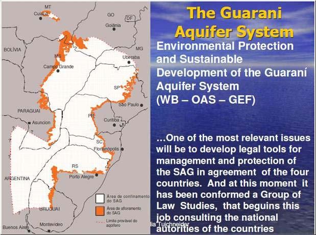
33 GUARANI AQUIFER SYSTEM Shared by: Brazil Paraguay Argentina Uruguay
34 GUARANI AQUIFER SYSTEM The Guarani Aquifer System (GAS) constitutes one of the largest reservoirs of groundwater in the world. The water in the Mesozoic sandstones can be found at depths between 50 m to 1500 m covered by thick layers of basalts. It contains an estimated 37,000 km³ of water, with a total recharge rate of about 166 km³/year from precipitation.
35
36 CASE STUDY Academia Nacional de Ciencias de Bolivia


37 Location Map 22º THE SILALA AQUIFER SYSTEM
38 SILALA AQUIFER SYSTEM The Silala Aquifer System discharges 500 liters/sec through more than 80 (in Bolivia) and 23 (in Chile) natural water springs. All the water is confined in a highly jointed Miocene ignimbrite at a depth between 50 m to 150 m. The sodium bicarbonate type A freshwater is 10,000 years old, free of arsenic and other contaminants. The surface water flows west towards Chile through man-made open channels.


39 Southern Bofedal Silala Bolivian Side Northern Bofedal


40 Main Gorge Silala Bolivian Side Main Open Channel


41 Main Gorge Fractured Ignimbrite Main Gorge Open Channels Silala Chilean Side

42 CASE STUDY Academia Nacional de Ciencias de Bolivia

43 YRENDA TOBA TARIJEÑO AQUIFER SYSTEM Superficial Total Areal: km2 Geological Formation: Quaternary / Tertiary nonconsolidated sediments Multi surface - Semi confined aquifer Location Map Source: Pasig, R


 Caiza River")
44 Range of the Aguarague Recharging Areas of the Tarijeño Aquifer Infiltration: 1. Direct rain waterfall (Piedemont sector /Aguarague) 2. Surface water courses (creeks and rivers / Pilcomayo River and Caiza River) Caiza River Pilcomayo River Source: Pasig, R
45 Academia Nacional de Ciencias de Bolivia
46 CONCLUSIONS The water crisis is primarily one of governance: institutions lack the capacity to overcome conflicting approaches in the use and allocation of water from within one basin or aquifer system, both at national and transboundary level Water-related systems are interdependent and have to be managed in an integrated manner Despite an increased dependency on groundwater resources, transboundary aquifers have received little attention in international law


47 THANKS

48 Academia Nacional de Ciencias de Bolivia

49 Academia Nacional de Ciencias de Bolivia

50 MAP OF TRANSBOUNDARY BASINS IN SOUTH AMERICA Source: National University of El Litoral, Argentina
51 LIST OF INTERNATIONAL TREATIES TREATY NAME COUNTRIES DATE TREATY BASIN AMAZON BASIN Exchange of notes constituting an agreement for the construction of a hydroelectric plant in Cachuela Esperanza, supplementary to the agreement on economic and technical cooperation. Agreement concerning the Cachuela Esperanza hydroelectric plant. Treaty for Amazonian Cooperation. Termination of the demarcation of the Peruvian-Ecuadorean frontier Brazil Bolivia Brazil Bolivia Bolivia Brazil Colombia Ecuador Guaina Perú Suriname Venezuela Perú Ecuador August 2, 1988 February 8, 1984 July 3, 1978 May 22, 1944 Beni Madeira Mamore Beni Amazon Amazon, Chira, Tumbes, Zarumilla
52 LIST OF INTERNATIONAL TREATIES TREATY NAME COUNTRIES DATE TREATY BASIN RIO DE LA PLATA BASIN Agreement for the use of natural resources and the development of the Cuareim river basin. Agreement constituting the trilateral commission for the development of the Pilcomayo river basin. Agreement for the multiple uses of the resources of the upper basin of the Bermejo river and the Grande de Tarija river. Agreement of cooperation for the use of natural resources and the development of the basin of the Cuareim river Complementary agreement to the basic scientific and technical cooperation agreement in the area of water resources Brazil Uruguay Argentina Bolivia Paraguay Argentina Bolivia Brazil Uruguay Brazil Uruguay May 6, 1997 September 2, 1995 June 9, 1995 March 11, 1991 March 11, 1991 Cuareim Pilcomayo Bermejo Grande de Tarija Cuareim Not specified
53 LIST OF INTERNATIONAL TREATIES TREATY NAME COUNTRIES DATE TREATY BASIN Decree No promulgating the agreement for water resources exploitation within the Uruguay river and its effluent the Pepiri- Guazu river Treaty for the development of the water resources contained in the border reaches of the Uruguay river and its effluent, the Pepiri- Guazu river. Agreement on Paraná River projects Statute of the Uruguay River in Salto, Eastern of Uruguay Treaty concerning the hydroelectric utilization of the water resources of the Parana River owned in condominium by Brazil and Paraguay. Brazil Argentina Brazil Argentina Argentina Brazil Paraguay Argentina Uruguay Brazil Paraguay June 29, 1983 May 17, 1980 October 19, 1979 February 26, 1975 April 26, 1973 Pepiri-Guazu, Uruguay Pepiri-Guazu, Uruguay Paraná Uruguay Iguassu, Paraná
54 LIST OF INTERNATIONAL TREATIES TREATY NAME COUNTRIES DATE TREATY BASIN Treaty on the boundary constituted by the Uruguay river Agreement concerning a study of the utilization of the water power of the Apipe Falls Agreement concerning cooperation in a study on the utilization of the water power of the Acaray and Monday rivers Agreement concerning the utilization of the rapids of the Uruguay river in the Salto Grande area Argentina Uruguay Argentina Paraguay Brazil Paraguay Argentina; Uruguay April 7, 1961 January 23, 1958 January 20, 1956 December 30, 1946 Uruguay Paraná Acaray Monday Uruguay Supplementary boundary treaty on the river Pilcomayo and protocol annexed to the treaty Argentina Paraguay June 1, 1945 Pilcomayo Supplementary boundary treaty Argentina Paraguay July 5, 1939 Pilcomayo
55 LIST OF INTERNATIONAL TREATIES TREATY NAME COUNTRIES DATE TREATY BASIN Convention to determine the legal status of the frontier between Brazil and Uruguay Protocol between Uruguay and Argentina dealing with the questions of the jurisdiction of the River Plate CHUY Complementary agreement to the basic scientific and technical cooperation agreement in the area of water resources Convention regarding the determination of the legal status of the frontier between Brazil and Uruguay MARONI Convention to fix the frontier of Surinamee and French Guiana Brazil Uruguay Argentina Uruguay Brazil Uruguay Brazil Uruguay France Netherlands December 20, 1933 January 5, 1910 March 11, 1991 December 20, 1933 September 30, 1915 Frontier or shared Waters Rio de la Plata Not specified Frontier or shared waters Maroni, Marowinjne
56 TREATY NAME COUNTRIES DATE TREATY BASIN LAGOON MIRIN LIST OF INTERNATIONAL TREATIES Convention regarding the determination of the legal status of the frontier between Brazil and Uruguay Protocol between Uruguay and Argentina dealing with the questions of the jurisdiction of the River Plate Complementary agreement to the basic scientific and technical cooperation agreement in the area of water resources Convention regarding the determination of the legal status of the frontier between Brazil and Uruguay Brazil Uruguay Argentina Uruguay Brazil Uruguay Brazil Uruguay December 20, 1933 January 5, 1910 March 11, 1991 December 20, 1933 Frontier or shared Waters Rio de la Plata Not specified Frontier or shared waters
57 LIST OF INTERNATIONAL TREATIES TREATY NAME COUNTRIES DATE TREATY BASIN LAKE TITICACA - POOPO Exchange of Diplomatic Notes related to the creation of the Autonomous Binational Authority of the Basin of the Lake Titicaca, Desaguadero River, Lake Poopó and Coipasa Salt Flat System Agreement on a preliminary economic study of the joint utilization of the waters of Lake Titicaca Preliminary convention concerning a study of the joint utilization of the waters of Lake Titicaca Exchange of Diplomatic Notes establishing a joint commission for study of the Puno-Guaqui railway line and joint use of the waters of Lake Titicaca Bolivia Perú Bolivia Perú Bolivia Perú Bolivia Perú June 21, 1993 February 19, 1957 July 30, 1955 April 20, 1955 Desaguadero, Poopó, Salar de Coipasa, Titicaca Lake Titicaca Lake Titicaca Lake Titicaca
58 LIST OF REGIONAL WATER PROGRAMMES Inter-American Network of Academies of Sciences IANAS Water Programme. Organization of American States / Unit of Sustainable Development and Environment (OAS / USDE). Comité Regional de Recursos Hídricos (CRRH). Global Water Partnership / South American Technical Advisory Committee (GWP / SAMTAC). International Hydrological Programme (IHP UNESCO). Hydrology for International Environment and Network Data. Flow Regimes from Integral Experimental and Network Data (FRIEND). ISARMAC / Americas - Internationally Shared Aquifer Resources Management. World-wide Hydrogeological Mapping and Assessment Programme (WHYMAP).
59 LIST OF REGIONAL WATER PROGRAMMES Centro del Agua para Zonas Aridas y Semiáridas del ALC (CAZALAC). Centro del Agua para el Trópico Húmedo del ALC (CATHALAC). Project for the Environmental Protection and Sustainable Development of the Guarani Aquifer System. Strategic Action Programme for the Binational Basin of the Bermejo River. Development and Implementation of Mechanisms to Disseminated Lessons Learned and Experiences in Integrated Transboundary Water Resources Management in Latin America and Caribbean DELTAmerica. The Integrated Watershed Management Practices for the Pantanal and Upper Paraguay River Basin Project. Inter-American Water Resources Network (IWRN) - UNESCO.
International Collaboration in Shared Riverbasins
 International Collaboration in Shared Riverbasins Marloes Bakker Universities Partnership for Transboundary Waters Transboundary Freshwater Dispute Database Oregon State University 3 November 2004, Dakar.
ANNEX 18 Integration Sectoral Processes
 INITIATIVE FOR THE INTEGRATION OF REGIONAL INFRASTRUCTURE IN SOUTH AMERICA IIRSA ANNEX 18 Integration Sectoral Processes IX Meeting of the Executive Steering Committee of IIRSA December 4th and 5th, Montevideo,
Annex Multilateral Conventions 1. SUBJECT Where and When Signed Multilateral Organization Vienna Convention on Vienna, April 24, 1963
 Annex 3 MULTILATERAL AND BILATERAL JUDICIAL COOPERATION INSTRUMENTS SIGNED BY COLOMBIA (Special Reference to Latin American Countries, Spain and Portugal) 1. Multilateral Conventions 1 SUBJECT Where and
Chapter 10 Study Guide SOUTH AMERICA
 Chapter 10 Study Guide SOUTH AMERICA When Spain and Portugal competed for trading lands in the New World, who came up with the line of demarcation to settle the dispute? The Caribbean Countries: Who was
ORGANIZATION OF AMERICAN STATES
 ORGANIZATION OF AMERICAN STATES CONTRIBUTIONS TO OAS' FUNDS BY DONOR Members: 2006 Prior Years FEMCIDI OAS Specific Funds Trust for the Americas Antigua & Barbuda $ 7,450 $ - $ 6,988 $ - $ - $ 14,438 Argentina
Activity Report 2011 IIRSA. Nineteenth Meeting of IIRSA National Coordinators Brasilia, November 29, 2011
 Activity Report 2011 IIRSA Nineteenth Meeting of IIRSA National Coordinators Brasilia, November 29, 2011 Areas of Work 2011 Integration Priority Project Agenda Project Portfolio Sectoral Integration Processes
Latin America s Physical Geography. EQ: What are characteristics of Latin America s physical features?
 Latin America s Physical Geography EQ: What are characteristics of Latin America s physical features? Your Task: We are going to participate in a Museum Walk! You will travel around the room with a partner
Month June 2011 South America (except Colombia for HA) Date of submission 01/07/11 MONTHLY REPORT
 Date of submission 01/07/11 MONTHLY REPORT") ANNEX IV-3 EUROPEAN COMMISSION HUMANITARIAN AID OFFICE (ECHO) Monthly report number 2011/6 Month June 2011 Country South America (except Colombia for HA) Date of submission 01/07/11 Author ECHO Quito MONTHLY
ANNEX IV-3 EUROPEAN COMMISSION HUMANITARIAN AID OFFICE (ECHO) Monthly report number 2011/6 Month June 2011 Country South America (except Colombia for HA) Date of submission 01/07/11 Author ECHO Quito MONTHLY
Latin America. Physical Geography
 Latin America Physical Geography Regions Latin America can be divided into separate regions based on physical geography or cultural geography. Regions If we look at physical geography Latin America has
Fieldwork Dates AmericasBarometer
 Fieldwork Dates AmericasBarometer 2004-2014 This document contains information regarding fieldwork s for the AmericasBarometer project, 2004-2014. Some information may be incomplete and we will up the
Geographic Qualities of South America
 Geographic Qualities of South America 1. South America is the fourth largest continent in area. It is located in the Western Hemisphere, lying southwest of North America. Most of South America lies in
Comprehension Questions:
 Unit 3: Central & South america Comprehension Questions: 1. What is the driest desert on earth? Atacama Desert 2. What two water routes were discovered in the 1500s to get around the tip of South America?
Inter-American Defense College
 http://www.jid.org/iadc.php Inter-American Defense College Inter-American Defense College Building Confidence & Security Since 1962 A Confidence & Security Building Measure Inter-American Defense College
VIII MEETING OF NATIONAL COORDINATORS. Pilot Project Program Border Crossings Summary and Conclusions. Jorge H. Kogan
 VIII MEETING OF NATIONAL COORDINATORS Pilot Project Program Border Crossings Summary and Conclusions Jorge H. Kogan Infrastructure Vice-Presidency - DAPS Andean Development Corporation Buenos Aires, June
South American Countries. Capital Location Population Terrain Climate
 South American Countries Capital Location Population Terrain Climate Andes Mountains Four large areas that make up the Central Plains: Llanos, the Selva, the Gran Chaco, and the Pampas Brazilian Highlands
Workshop on Guiana Shield Biodiversity Corridor to streamline support for the achievement of the Aichi Biodiversity Targets
 Workshop on Guiana Shield Biodiversity Corridor to streamline support for the achievement of the Aichi Biodiversity Targets ACTION PLAN Preamble: We, the participants of the workshop called, Guiana Shield
Chapter 19 Test on South America
 Name Part 1 - Labeling (27 pts.) Chapter 19 Test on South America Score A. Locate the countries and territory contained in the word box below on the map of South America on the next page. Write the name
Interactive research in water and mining in Peru, Bolivia and Chile
 Interactive research in water and mining in Peru, Bolivia and Chile Jaime Amezaga, Tobias Roetting, Paul Younger Hydrogeochemical Engineering Research and Outreach, Sir Joseph Swan Institute for Energy
The hemispheric program for the eradication of foot and mouth disease challenges and lessons learned
 The hemispheric program for the eradication of foot and mouth disease challenges and lessons learned OIE/FAO Global Conference on Foot and Mouth Disease. The Way Towards Global Control 24 26 June 2009
United Nations Environment Programme
 United Nations Environment Programme Twelfth Forum of Ministers of the Environment of Latin America and the Caribbean Bridgetown, Barbados 2 nd to 7 th March 2000 A. Preparatory Meeting of Experts 2 nd
35. SUPPLEMENTARY BOUNDARY TREATY 1 BETWEEN ARGENTINA AND PARAGUAY, SIGNED AT BUENOS AIRES, JULY
 Title: Supplementary boundary treaty between Argentina and Paraguay on the river Pilcomayo Parties: Argentina, Paraguay Basin: Pilcomayo Date: 6/1/1945 Argentina-Paraguay 35. SUPPLEMENTARY BOUNDARY TREATY
Essential Questions. 1. How have historical figures and events affected South America today?
 South America Essential Questions 1. How have historical figures and events affected South America today? 2. How has location affected the development of countries in South America? 3. How has the role
Global importance of the La Plata River Basin
 CONFRONTING THE CHALLENGES OF CLIMATE VARIABILITY AND CHANGE THROUGH AN INTEGRATED STRATEGY FOR THE SUSTAINABLE MANAGEMENT OF THE LA PLATA RIVER BASIN (LPB) 1 Global importance of the La Plata River Basin
-Dr Panambi Abadie Executive Secretary, AUGM
 Workshop 3: Perceptions of the Erasmus Mundus programme in third-countries. -Dr Panambi Abadie Executive Secretary, AUGM EM-iDEA Conference, Ghent 23/11/2011 1 PERSPECTIVES OF AUGM ON THE EM PROGRAMME
Pantanal Forever Programme
 Pantanal Forever Programme The Pantanal Basin Upper Paraguay River Basin Bolivia + Paraguay + Brazil = 624.320 km2 Pantanal = 158.592 km2 Plateau = 465.728 km2 Cattle ranching and agriculture are the most
ICAO regional technical cooperation tools for the implementation of air navigation and safety improvements
 RAAC/13-WP/11 10/11/13 International Civil Aviation Organization South American Regional Office Thirteenth Meeting of Civil Aviation Authorities of the South American Region (RAAC/13) (Bogota, Colombia,
DOWNLOAD OR READ : MAPPING SOUTH AMERICA PDF EBOOK EPUB MOBI
 DOWNLOAD OR READ : MAPPING SOUTH AMERICA PDF EBOOK EPUB MOBI Page 1 Page 2 mapping south america mapping south america pdf mapping south america South America PDF maps Free South America maps for students,
Name: Hour: Day: The Land and Its Regions (pg ) Define, in your own words, escarpment. Define, in your own words, sertão
 Define, in your own words, escarpment. Define, in your own words, sertão") Name: Hour: Day: World Geography Guided Reading Notes Chap 12 & 13 --- ANSWER IN COMPLETE SENTENCES!!!! READ EACH QUESTION CAREFULLY & ANSWER COMPLETELY!!!! Objectives: Upon completion of reading you should
Name: Hour: Day: World Geography Guided Reading Notes Chap 12 & 13 --- ANSWER IN COMPLETE SENTENCES!!!! READ EACH QUESTION CAREFULLY & ANSWER COMPLETELY!!!! Objectives: Upon completion of reading you should
for HUB MSMEs IX Meeting of the Executive Steering Committee of IX Meeting of the Executive Steering Committee of IIRSA
 INITIATIVE FOR THE INTEGRATION OF REGIONAL INITIATIVE FOR THE INTEGRATION OF REGIONAL INFRASTRUCTURE IN SOUTH AMERICA INFRASTRUCTURE IN SOUTH AMERICA IIRSA IIRSA ANNEX ANNEX 13 11 Project: PARAGUAY-PARANA
A funny sounding lake. South American Landforms, Climate, and Vegetation
 A funny sounding lake South American Landforms, Climate, and Vegetation 3 4 Essential Question: How have physical features and climate affected the population distribution of Latin America? 5 I. Landforms
INDEX. B Birdlife International, 130, 136, 141, 142
 INDEX A Accountability, 161 Accountability politics, 19, 135 Agribusiness, 46, 50, 51, 65, 78, 79, 81, 83 Agriculture production, 45, 49, 80, 109, 130, 141 Alianza Bolivariana para los Pueblos de nuestra
1. Introduction. 2. Basic Fundamentals. 4. Results. 5. Initiatives. 6. Final Conclusions.
 1 1. Introduction. 2. Basic Fundamentals. 3. Small member states of the OAS, CARICOM and IAD 4. Results. 5. Initiatives. 6. Final Conclusions. 2 THE IADB IS MANDATED BY STATUTE TO ADDRESS THE NEEDS OF
THE PHYSICAL AND CULTURAL GEOGRAPHY OF SOUTH AMERICA
 THE PHYSICAL AND CULTURAL GEOGRAPHY OF SOUTH AMERICA 1 Global location Relative to European capitals Relative to US cities Time zones Two oceans Pacific rim countries - farther to Asia than USA Not on
Multi stakeholders interactions in resource allocation in arid and semi-arid areas
 Multi stakeholders interactions in resource allocation in arid and semi-arid areas Dr Jaime M Amezaga Newcastle University The Challenge of Sustainable Water Futures Newcastle14-15 July 2011 Water Futures
TECHNICAL SEMINAR ON TOURISM INVESTMENTS IN THE AMERICAS Asuncion, Paraguay. May 17-18, 2011
 TECHNICAL SEMINAR ON TOURISM INVESTMENTS IN THE AMERICAS Asuncion, Paraguay May 17-18, 2011 STRUCTURE OF PRESENTATION CONTEXT TOURISM IN THE AMERICAS ROLES OF INSTITUTIONS FOCUS ON OAS AS A MULTILATERAL
Challange and oppotunity to Water Resouces Management in Latin America and the Caribeann «Transboundary Water Management»
 Challange and oppotunity to Water Resouces Management in Latin America and the Caribeann «Transboundary Water Management» Latin American Network of Basin Organisms LANBO Red Latinoamericana de Organismos
*Latin America spans 7,000 miles, from Mexico to Tierra Del Fuego. *3 Regions: Central America, South America, and the Caribbean.
 Physical Geography Latin America spans 7,000 miles, from Mexico to Tierra Del Fuego *3 Regions: Central America, South America, and the Caribbean. *Intro clip: http://www.youtube.com/watch?v=cffp6rza3
Meeting of. Rio de. Janeiro, Brazil. the Integration. System (CMS) Continuous. 3, 4 and 5. obstacles and
 Continuous. 3, 4 and 5. obstacles and") Meeting of the Executive Technical Group on the Integration Priority Project Agenda (API) and the Continuous Monitoring System (CMS) August 27 and 28, 2013 Rio de Janeiro, Brazil NOTES OF THE MEETING On
Meeting of the Executive Technical Group on the Integration Priority Project Agenda (API) and the Continuous Monitoring System (CMS) August 27 and 28, 2013 Rio de Janeiro, Brazil NOTES OF THE MEETING On
Report for the 39 Session of the World Heritage Committee Bonn (Germany), 28 June to 8 July 2015
, 28 June to 8 July 2015") Report for the 39 Session of the World Heritage Committee Bonn (Germany), 28 June to 8 July 2015 Date of the Report: 26 th, March 2015 Name of the Centre: Centro Regional de Treinamento em Gestão do Patrimônio
Report for the 39 Session of the World Heritage Committee Bonn (Germany), 28 June to 8 July 2015 Date of the Report: 26 th, March 2015 Name of the Centre: Centro Regional de Treinamento em Gestão do Patrimônio
EUROPEAN COMMISSION DIRECTORATE-GENERAL HUMANITARIAN AID AND CIVIL PROTECTION - ECHO
 EUROPEAN COMMISSION DIRECTORATE-GENERAL HUMANITARIAN AID AND CIVIL PROTECTION - ECHO Monthly report number 2013/10 Month OCTOBER Country South America (except Colombia for HA) Date of submission 08/11/13
Brazil. Brazil A Reading A Z Level J Leveled Book Word Count: 279 LEVELED BOOK J
 Brazil A Reading A Z Level J Leveled Book Word Count: 279 Discussion Questions Evaluate: What is interesting about the Amazon rainforest? Analyze: Why do you think the author calls Brazil an exciting country?
XXXIX REPICA, JULY 25-28, 2017, BELIZE CITY, BELIZE
 LA IMPORTANCIA DE LAS ASOCIACIONES PUBLICO PRIVADAS EN EL DESARROLLO PORTUARIO XXXIX REPICA, JULY 25-28, 2017, BELIZE CITY, BELIZE Jorge Durán Chief of the Secretariat Inter-American Committee on Ports
INITIATIVE FOR THE INTEGRATION OF REGIONAL INFRASTRUCTURE IN SOUTH AMERICA (IIRSA) Ninth Meeting of the Executive Steering Committee
 Ninth Meeting of the Executive Steering Committee") INITIATIVE FOR THE INTEGRATION OF REGIONAL INFRASTRUCTURE IN SOUTH AMERICA (IIRSA) Ninth Meeting of the Executive Steering Committee December 4th and 5th, 2007 Montevideo, Republic of Uruguay ANNEX 8 Report
INITIATIVE FOR THE INTEGRATION OF REGIONAL INFRASTRUCTURE IN SOUTH AMERICA (IIRSA) Ninth Meeting of the Executive Steering Committee December 4th and 5th, 2007 Montevideo, Republic of Uruguay ANNEX 8 Report
September. ECHO Quito team MONTHLY REPORT
 EUROPEAN COMMISSION HUMANITARIAN AID OFFICE (ECHO) Monthly report number 2012/09 Month Country September South America (except Colombia for HA) Date of submission 04/10/12 Author ECHO Quito team 1. SUMMARY
South America (except Colombia for HA) Date of submission 02/08/12. ECHO Quito team MONTHLY REPORT
 Date of submission 02/08/12. ECHO Quito team MONTHLY REPORT") ANNEX IV-3 EUROPEAN COMMISSION HUMANITARIAN AID OFFICE (ECHO) Monthly report number 2012/07 Month July Country South America (except Colombia for HA) Date of submission 02/08/12 Author ECHO Quito team
ANNEX IV-3 EUROPEAN COMMISSION HUMANITARIAN AID OFFICE (ECHO) Monthly report number 2012/07 Month July Country South America (except Colombia for HA) Date of submission 02/08/12 Author ECHO Quito team
MULTILATERALISM AND REGIONALISM: THE NEW INTERFACE. Chapter XI: Regional Cooperation Agreement and Competition Policy - the Case of Andean Community
 UNCTAD/DITC/TNCD/2004/7 UNITED NATIONS CONFERENCE ON TRADE AND DEVELOPMENT Geneva MULTILATERALISM AND REGIONALISM: THE NEW INTERFACE Chapter XI: Regional Cooperation Agreement and Competition Policy -
MARM ACTIVITIES ON WATER IN IBERO-AMERICA
 Conferencia de Directores Iberoamericanos del Agua (CODIA) Secretaría Técnica Permanente (STP) MARM ACTIVITIES ON WATER IN IBERO-AMERICA SPANISH COOPERATION Miguel Antolín Martínez Dr. ICCP Head of International
South America. Land of Color and Contrast
 South America Land of Color and Contrast Home to: *The world s largest river system *The longest mountain chain, and second tallest mountains *Earth s driest desert *One of the world s great grassland
CHAPTER Latin America. Regional Atlas Study Guide. 2 Chapter A. As You Read. B. Reviewing Vocabulary
 CHAPTER 28 9 Many Th ew inventions new Regional Atlas Study Guide Latin America Directions: As you work through the Regional Atlas, complete the chart below by writing two details about each Latin American
Public Works Research Institute
 Public Works Research Institute INTERNATIONAL WORKSHOP ON WATER HAZARD AND RISK MANAGEMENT SOME EXPERIENCES OF FLOOD MANAGEMENT IN ARGENTINA VÍCTOR POCHAT National Director for Water Policies,Coordination
The Lesser Antilles. Dominican Republic), and Puerto Rico
, and Puerto Rico") The Caribbean Islands are archipelagoes or groups of islands. The major archipelagoes are: The Greater Antilles - Cuba, Jamaica, Hispaniola (Composed of Haiti and the Dominican Republic), and Puerto Rico
The Caribbean Islands are archipelagoes or groups of islands. The major archipelagoes are: The Greater Antilles - Cuba, Jamaica, Hispaniola (Composed of Haiti and the Dominican Republic), and Puerto Rico
Created by Bobbie Kalman
 Created by Bobbie Kalman For my longtime friend Tony Zinnanti and his Brazilian family, Alba and Bianca, with much love to you all Author and Editor-in-Chief Bobbie Kalman Editors Kathy Middleton Crystal
Doing Business in Latin America and the Caribbean. Rita Ramalho Program Manager
 Doing Business in Latin America and the Caribbean Rita Ramalho Program Manager What does Doing Business measure? Doing Business indicators: Focus on regulations relevant to the life cycle of a small to
ASSEMBLY 35TH SESSION
 1 27/9/04 ASSEMBLY 35TH SESSION ECONOMIC COMMISSION Agenda Item 27: Regulation of international air transport services, and outcome of the fifth Worldwide Air Transport Conference RIGHTS AND OBLIGATIONS
Objective. Students will familiarize themselves with the physical features and climates of Latin America.
 Journal Write KWL What do you KNOW about Latin America? What do you WANT TO KNOW about Latin America? What did you LEARN today that you didn t know before? Latin America Objective Students will familiarize
UN-GGIM:Americas. UN-GGIM Expanded Bureau Meeting 7-9 December 2016, UN Headquarters New York. Rolando Ocampo President of UN-GGIM:Americas
 UN-GGIM:Americas UN-GGIM Expanded Bureau Meeting 7-9 December 2016, UN Headquarters New York Rolando Ocampo President of UN-GGIM:Americas Antigua and Barbuda 38 Member States Argentina Bahamas Belize Bolivia
Latin America. Chapter 9 Physical Geography
 Latin America Chapter 9 Physical Geography Latin American Regions Middle America includes Mexico and the Central American countries The Caribbean Islands South America Mexico Landforms Sierra Madre Oriental
COMPETITIVENESS Vs. SECURITY: STRIKING THE RIGHT BALANCE
 COMPETITIVENESS Vs. SECURITY: STRIKING THE RIGHT BALANCE Hemispheric Conference Miami, 22-24 February, 2017 Jorge Durán Chief of the Secretariat Inter-American Committee on Ports (CIP) jduran@oas.org Inter-American
Ibero-American Road Safety Observatory
 Ibero-American Road Safety Observatory IRTAD Outreach activities in Latin America and the Caribbean countries 8 rd Road Safety Working Group Meeting April, 3-4, 2017 Podgorica - Montenegro Anna Ferrer
NZQA registered unit standard version 2 Page 1 of 5
 Page 1 of 5 Title Demonstrate knowledge of Central American or South American countries as tourist destinations Level 3 Credits 8 Purpose People credited with this unit standard are able to: locate Central
SPECIAL SESSIONS MONDAY
 SPECIAL SESSIONS MONDAY 9:30 12:20 Opening Ceremony Gran Cancun Room/ 12:40 14:10 HLP: Water and the SDGs Gran Cancun Room/ 14:10-15:30 LUNCH Lounge Zone Regular Session 1 Cozumel 1 SS-39(A): Sustainability
Report for the 40th Session of the World Heritage Committee Istanbul (Turkey), 10 to 20 July 2016
, 10 to 20 July 2016") Report for the 40th Session of the World Heritage Committee Istanbul (Turkey), 10 to 20 July 2016 Date of the Report: Rio de Janeiro, April 29, 2016. Name of the Centre: Regional Heritage Management Training
Report for the 40th Session of the World Heritage Committee Istanbul (Turkey), 10 to 20 July 2016 Date of the Report: Rio de Janeiro, April 29, 2016. Name of the Centre: Regional Heritage Management Training
Macmillan Cultural Readers ELEMENTARY LEVEL. Brazil MACMILLAN
 Macmillan Cultural Readers ELEMENTARY LEVEL SUSAN HOLDEN AND Alberta White Brazil MACMILLAN Macmillan Cultural Readers ELEMENTARY LEVEL Founding Editor of the Macmillan Readers: John Milne The Macmillan
Successful Experiences in Rio Grande/Rio Bravo Watershed Management
 Successful Experiences in Rio Grande/Rio Bravo Watershed Management 5 th th World Water Forum Istanbul, Turkey March 22-23, 23, 2009 Introduction A watershed with many voices a medley of cultures, customs,
No ARGENTINA and PARAGUAY. Treaty of Yacyretâ. Signed at Asuncion on 3 December ARGENTINE et PARAGUAY
 No. 23141 ARGENTINA and PARAGUAY Treaty of Yacyretâ. Signed at Asuncion on 3 December 1973 Authentic text: Spanish. Registered by Argentina on 16 November 1984. ARGENTINE et PARAGUAY Traité de Yacyretâ.
The Coasts Of Chile, Bolivia, And Peru By Anon
 The Coasts Of Chile, Bolivia, And Peru By Anon If you are searching for a book by Anon The Coasts of Chile, Bolivia, and Peru in pdf format, then you have come on to the faithful site. We furnish full
International Groundwater Resources Assessment Centre. Transboundary Aquifers within the Second Assessment: the case of Dinaric Karst Aquifer System
 International Groundwater Resources Assessment Centre Transboundary Aquifers within the Second Assessment: the case of Dinaric Karst Aquifer System Dr Neno Kukuric Sarajevo, 2009 Content of the presentation
URBAN FLOODS IN SOUTH AMERICA
 URBAN FLOODS IN SOUTH AMERICA Dr. Carlos E.M. Tucci IPH Institute of Hydraulic Research SAMTAC/GWP Pantanal during wet season CONTENTS Urban development Floods types Issues on urban drainage floods Issues
Regional Activities. 25 June Carlos Vogeler Director Executive Secretary for Members Relations and Regional Director for the Americas UNWTO
 Regional Activities 25 June 214 Carlos Vogeler Director Executive Secretary for Members Relations and Regional Director for the Americas UNWTO UNWTO documents distributed 1. UNWTO Tourism Highlights (214
INITIATIVE FOR THE INTEGRATION OF REGIONAL INFRASTRUCTURE IN SOUTH AMERICA. Tenth Meeting of the Executive Steering Committee
 INITIATIVE FOR THE INTEGRATION OF REGIONAL INFRASTRUCTURE IN SOUTH AMERICA Tenth Meeting of the Executive Steering Committee December 4th and 5th, 2008 Cartagena de Indias, Republic of Colombia MINUTES
Protection and Sustainable Use of the Dinaric Karst Transboundary Aquifer System
 Protection and Sustainable Use of the Dinaric Karst Transboundary Aquifer System Second Workshop "River Basin Commissions and Other Joint Bodies for Transboundary Water Cooperation: Technical Aspects "
The Timok River Basin in Serbia
 The Timok River Basin in Serbia UNECE Workshop on Integrated Transboundary Water Resources Management in SEE, Sarajevo, 18-20 May, 2009 Dragana Ninković, Dipl.-Ing. Dušan Dobričić, Dipl.-Ing. Content 1.
Peru Economic and Trade Relations with the European Union. Jose Luis Silva Martinot Minister of Foreign Trade and Tourism June, 2012
 Peru Economic and Trade Relations with the European Union Jose Luis Silva Martinot Minister of Foreign Trade and Tourism June, 2012 Peruvian Integration to the global economy through Free Trade Agreements
Latin America and the Caribbean: Fact Sheet on Economic and Social Indicators
 Latin America and the Caribbean: Fact Sheet on Economic and Social Indicators Dindi R. Robinson Barbara Salazar Torreon May 30, 2013 CRS Report for Congress Prepared for Members and Committees of Congress
LACNIC REPORT. ARIN XI - Memphis, USA. Raúl Echeberría LACNIC CEO < > ARIN XI
 LACNIC REPORT Raúl Echeberría LACNIC CEO < raul@lacnic.net > - Memphis, USA INTRODUCTION LACNIC became the fourth RIR in October 31st 2002 through the resolution of ICANN Board in Shanghai Meeting http://www.icann.org/minutes/prelim-report-31oct02.htm#finalapprovaloflacnic
Broadband as an opportunity for Development
 Broadband as an opportunity for Development December 2013 Antonio García Zaballos http://www.iadb.org The Inter-American Development Bank Discussion Papers and Presentations are documents prepared by both
Andean Mountain Initiative. World Mountain Forum 2018 Bishkek, October 23th, 2018
 Andean Mountain Initiative World Mountain Forum 2018 Bishkek, October 23th, 2018 The Andes range mountains The Andes are approximately 7,000 km long and are the world s longest terrestrial mountain range,
Argentina Country Case Study
 ORGANISATION FOR ECONOMIC CO-OPERATION AND DEVELOPMENT Annex I Expert Group Seminar Working Together to Respond to Climate Change Domestic Policy Frameworks on Adaptation to Climate Change in Water Resources
DOWNLOAD OR READ : VENEZUELA PERU ECUADOR AND COLOMBIA BARTHOLOMEW WORLD TRAVEL MAP PDF EBOOK EPUB MOBI
 DOWNLOAD OR READ : VENEZUELA PERU ECUADOR AND COLOMBIA BARTHOLOMEW WORLD TRAVEL MAP PDF EBOOK EPUB MOBI Page 1 Page 2 venezuela peru ecuador and colombia bartholomew world travel map venezuela peru ecuador
VI Meeting of the Executive Steering Committee
 VI Meeting of the Executive Steering Committee 23 24 November, 2004 Lima, Republic of Peru 2004 Project Portfolio INITIATIVE FOR THE INTEGRATION OF REGIONAL INFRASTRUCTURE IN SOUTH AMERICA Project Portfolio
EU Trade policy in Latin America
 EU Trade policy in Latin America Thomas LE VAILLANT European Commission DG TRADE - Relations with Latin America Topics 1.Trade and investment flows 2. Regionalism in Latin America 3. State of play 4. Architecture
THE SAN JUAN RIVER BASIN PROJECT
 Formulation of a Strategic Actions Program for the Integrated Management of the Hydrological Resources and Sustainable Development of the San Juan River Basin and its Coastal zone PROCUENCA SAN JUAN THE
The Senate and the Chamber of Representatives of the Eastern Republic of Uruguay, meeting in general assembly, decree:
 Page 1 Act 17.033 of 20 November 1998 establishing the boundaries of the territorial sea, the adjacent zone, the exclusive economic zone, and the continental shelf The Senate and the Chamber of Representatives
Protection and Sustainable Use of the Dinaric Karst Transboundary Aquifer System
 Protection and Sustainable Use of the Dinaric Karst Transboundary Aquifer System What is DIKTAS? DIKTAS is a project initiated by the aquifer-sharing states and supported by GEF - Global Environment Facility.
Indicative Territorial Planning
 INITIATIVE INITIATIVE FOR FOR THE THE INTEGRATION INTEGRATION OF OF REGIONAL REGIONAL INFRAESTRUCTURE INFRAESTRUCTURE IN IN SOUTH SOUTH AMERICA AMERICA Indicative Territorial Planning IIRSA PROJECT PORTFOLIO
DEVELOPMENT AID AT A GLANCE
 DEVELOPMENT AID AT A GLANCE STATISTICS BY REGION 3. AMERICA 2018 edition All the data in this report are available at: http://www.oecd.org/dac/financing-sustainable-development/ 3.1. ODA TO AMERICA - SUMMARY
STUDY GUIDE. The Land. Physical Features of Latin America. Chapter 8, Section 1. Terms to Know DRAWING FROM EXPERIENCE ORGANIZING YOUR THOUGHTS
 For use with textbook pages 193 198. The Land Terms to Know cordillera A mountain range that runs parallel to another mountain range (page 194) altiplano A high plain (page 194) escarpment A steep cliff
2012. Proceedings of the 11 European Geoparks Conference. AGA Associação Geoparque Arouca, Arouca, 5-6.
 References to this volume It is suggested that either the following alternatives should be used for future bibliographic references to the whole or part this volume: th Sá, A.A., Rocha, D., Paz, A. & Correia,
HLC Travel Agency and Event Management Training course. 2º year. Academic year:
 Unit 1.- Worldwide tourist geography: The OMT region of America. Index: 1. Geographical features of America. 2. Hydrography of America. Rivers and lakes. 3. The American coast. 4. Vegetation. 5. American
Congressional Briefing Southern California Air Cargo Traffic and its Impact on the Region s Economy
 Congressional Briefing Southern California Air Cargo Traffic and its Impact on the Region s Economy World Trade Week Briefing Series Los Angeles Chamber of Commerce Thursday, March 17, 2011 The Role of
Experience from Chile
 MULTIMODAL TRANSPORT AND TRANSIT SOLUTIONS Experience from Chile Ashgabat, Turkmenistan 26 27 november 2016 MULTIMODALITY Multimodal Transport takes us to address the following issues: 1.- Transport costs
LACNIC REPORT. RIPE 46 Amsterdam Netherlands. Raúl Echeberría CEO RIPE 46
 LACNIC REPORT Raúl Echeberría CEO Amsterdam Netherlands INTRODUCTION LACNIC became the fourth RIR in October 31st 2002 through the resolution of ICANN Board in Shanghai Meeting http://www.icann.org/minutes/prelim-report-31oct02.htm#finalapprovaloflacnic
Transboundary Diagnostic Analysis for the La Plata River Basin TDA
 Versión para validación Transboundary Diagnostic Analysis for the La Plata River Basin TDA December 2016 Transboundary Diagnostic Analysis for the La Plata River Basin TDA Index 13 Prefacio 17 Presentation
Catchment and Lake Research
 LARS 2007 Catchment and Lake Research Multilateral versus bilateral agreements for the establishment of river based organizations: comparison of legal, economic and social benefits in the Zambian experience.
UNF. Regional Oficce for
 UNF. Regional Oficce for Latin AiTÍerica The preparation Acknowledgements MUNICIPAL WASTE WATER AS A LAND-BASED SOURCE OF POLLUTION IN COASTAL AND MARINE AREAS 1. Foreword The diagnosis presented in this
Dr. Christopher Brown New Mexico State University GEF Project Rio Meeting Ciudad Juárez, México 3-5 October 2006
 Political and Institutional Aspects of Rio Grande/ Río Bravo Basin Management Dr. Christopher Brown New Mexico State University GEF Project Rio Meeting Ciudad Juárez, México 3-5 October 2006 Institutional
RESPONSE OF RANDOMIZED SUBSETS OF RAINFALL GAUGES OVER A PARANÁ RIVER SUB-BASIN
 RESPONSE OF RANDOMIZED SUBSETS OF RAINFALL GAUGES OVER A PARANÁ RIVER SUB-BASIN Thais Fujita, A. P. Rudke, M. V. B. de Morais, S. A. A. Rafee, R. A. F. de Souza, R. V. A. de Souza, E. D. de Freitas, L.
Paraguay Parana Wetland System: valuing wetlands and local knowledge for integration
 Paraguay Parana Wetland System: valuing wetlands and local knowledge for integration Session Rivers and Wetlands: A negotiated Approach Presenter: Rafaela Nicola Ecoa/Pantanal Network World Water Forum
Inventory of managed aquifer recharge schemes in Latin America
 Sponsored by Programa de Innovación y Capital Humano para la Competitividad Junior Research Group Global Change 4+1 Inventory of managed aquifer recharge schemes in Latin America José Pablo Bonilla Valverde,
Foromic. 1 Welcome to Foromic 2 Background and Impact. 3 Participation by Country 4 Participation by Type of Institution 5 Agenda Content
 Table of contents Foromic 1 Welcome to Foromic 2 Background and Impact Foromic 2016 in numbers 3 Participation by Country 4 Participation by Type of Institution 5 Agenda Content General Structure 6 General