Field Guide To Conservation Lands
|
|
|
- Clyde Greer
- 5 years ago
- Views:
Transcription


1 Sarasota County Field Guide To Conservation Lands discovernaturalsarasota.org

2 Heritage of Stewardship Stewardship is a unique part of Sarasota County s rich heritage. Before there were government programs to buy land, stewardship could be seen in the land operations of notable community pioneers such as T. Mabry Carlton, Jr., Berryman Buster Longino, and others. While working the lands, these families managed them to ensure their sustainable function and value. Today, this heritage is reflected in the voter adopted acquisition programs. The lands these families once managed provide key opportunities and linkages within our conservation network. The people of Sarasota County, in understanding the ecological, historical and cultural value of natural areas, have worked to preserve wild spaces for wildlife habitat and outdoor recreation. In 1999, voters reaffirmed their commitment to these objectives, showing overwhelming support for an ad valorem tax referendum to support land conservation. These conservation lands help to protect our watersheds, preserve our cultural links to the land, maintain wildlife and plant diversity, and provide outdoor recreation opportunities. Our ecosystem management seeks to restore and maintain a natural balance which preserves the quality of these diverse landscapes for the benefit of visitors and wildlife. As part of this effort, Sarasota County's environmental professionals apply a variety of specialized methods, including mechanical mowing of vegetation, selective harvesting of timber, prescribed fire, managed grazing, invasive plant and animal management, hydrological restoration, and vegetation planting. Monitoring, often facilitated by volunteers, enables us to gauge our effectiveness and develop responsive approaches. We balance conservation goals with a focus on nature-based recreation that compliments the natural and cultural resources unique to each land we manage. This framework allows us to accommodate a variety of engaging experiences while maintaining the ecological integrity of the landscape. This balanced, adaptive program continues Sarasota County's history of stewardship to maintain ecological functions, preserve diverse habitats, and provide recreation for residents and visitors to enjoy our community's wild places. 2

3 Table of Contents Heritage of Stewardship... 2 Table of Contents... 3 Important Information... 4 How to Use this Guide... 5 What Kind of Wild Are You?... 6 Sarasota County Wildlife Locator Map At A Glance Guide Northern Region Bayonne Celery Fields and Palmer Gazebo Circus Hammock Old Miakka Preserve Red Bug Slough Preserve Rothenbach Park Ted Sperling Park at South Lido Urfer Family Park Central Region Deer Prairie Creek Preserve Jelks Preserve Snook Haven Park Sleeping Turtles Preserve North Sleeping Turtles Preserve South T. Mabry Carlton, Jr. Memorial Reserve Southern Region Caspersen Beach Curry Creek Preserve Lemon Bay Park and Environmental Center Manasota Scrub Preserve Myakka Islands Point Pocono Trail Preserve Shamrock Park and Nature Center South Venice Lemon Bay Preserve Discover More Of Natural Sarasota - Other Places to Visit... Back Cover
4 Important Information Sarasota County has over 67,000 acres of natural lands to explore. Most areas included in this guide are wild, primitive and unpredictable. Please follow these guidelines to remain safe. Have a plan! Let others know where you will be and when you plan to return. Before leaving home, confirm SCAT route information and park hours. Bring any medications you might need. Water, sun-block, a rain jacket, insect repellant and sturdy shoes are recommended for hiking. Be aware of your surroundings at all times. Keep a safe distance from aggressive wild animals such as feral hogs and alligators. Read and respect notices of land management activities that may be posted and may restrict access to part of the property. Prescribed burning, exotic plant removal and other habitat restoration may be occurring during your visit. Take your time and stay on the trails. Enjoy the lands that have been preserved for this and future generations. April - October November - March Snook Haven Park Monday Tuesday - Thursday Friday-Saturday Sunday CLOSED 9 a.m. - 9 p.m. 11 a.m p.m. Noon - 5 p.m. Hours Exceptions Prohibitions Disclaimer 7:30 a.m. - 8 p.m. 7:30 a.m. - 6 p.m. Rothenbach Park March - October November - February 6 a.m. - 9 p.m. 6 a.m. - 6 p.m. To ensure public safety and environmental protection, the following activities are not allowed: Open fires Removal of plants, animals or Smoking archeological or cultural resources Unleashed pets, except in Off-road vehicles designated areas The Sarasota County Field Guide to Conservation Lands 2011/2012 is intended to be a guide for recreational use only and not relied upon for specific site navigational use. Maps indicated in this guide are for trail direction and amenities only. Sarasota County is not responsible for injuries incurred during visits on conservation lands. For more information, visit or call (941) ask for Natural Resources


5 How to Use this Guide This guide is organized in three regions for ease of navigation: Northern, Central and Southern regions. Within each region, brief site summaries include addresses, GPS coordinates, informative facts, plus a trail map and At A Glance icons which illustrate the amenities and uses featured on the site. Important information to keep you safe and protect the lands has been provided on the previous page. We hope that you will enjoy the beautiful natural lands of Sarasota County for years to come. To help you make the most of your time, we have provided What Kind of Wild Are You? section that highlights specific opportunities. On the back page, Other Places to Visit lets you discover more of what Sarasota has to offer. Please keep this guide for future visits or share with a friend or family member. For more information about Sarasota County s natural lands, please refer to our website visit Discover Natural Sarasota online at contact the Sarasota County Call Center at , or scan the smartphone tag located on the back cover. At A Glance Icons Map Legend


6 What Kind of Wild Are You? Nature Seeker Nature Seekers are hoping to catch a glimpse of creatures, regardless of whether they walk, crawl, swim or fly, that call our wild places home. Or discover native plants that you have never seen before, like the elusive pine lily. You can explore lands prized for their vast diversity. A surprise awaits you! Best opportunities Map # 2 Celery Fields and Palmer Gazebo 4 Old Miakka Preserve 10 Jelks Preserve 12 Sleeping Turtles Preserve North 13 Sleeping Turtles Preserve South 20 Manasota Scrub Preserve 21 Myakka Islands Point 24 South Venice Lemon Bay Preserve Family Trailblazer Family trailblazers are adventurers that can discover the wonders of nature and create memories that will last for decades. Family friendly areas await with paved and unpaved easy trails, playgrounds, pavilions and tables for picnics, scenic bike trails and vast beaches to stroll, to name a few. Best opportunities Map # 2 Celery Fields and Palmer Gazebo 5 Red Bug Slough Preserve 6 Rothenbach Park 7 Ted Sperling Park at South Lido Beach 8 Urfer Family Park 17 Caspersen Beach 19 Lemon Bay Park and Environmental Center 23 Shamrock Park and Nature Center 6


7 Wildlands Enthusiast Wildlands Enthusiasts can hear the call of the wild challenging them to experience wilderness at its finest. Expect the unexpected - a true wilderness at your beck and call. With hundreds of miles of primitive hiking, Sarasota County s rugged back country offers a true challenge for hikers. Best opportunities Map # 9 Deer Prairie Creek Preserve 14 T. Mabry Carlton, Jr. Memorial Reserve Weekend Warrior Whether scouting the perfect picnic spot or looking for a leisurely stroll, Weekend Warriors of all stripes will be sure to find their next great conquest. Create a perfect weekend with short hikes, kayaking, fishing, bird watching, horseback riding, or swimming - whatever you desire. Best opportunities Map # 2 Celery Fields and Palmer Gazebo 4 Old Miakka Preserve 7 Ted Sperling Park at South Lido Beach 10 Jelks Preserve 11 Snook Haven Park 12 Sleeping Turtles Preserve North 13 Sleeping Turtles Preserve South 17 Caspersen Beach 18 Curry Creek Preserve 20 Manasota Scrub Preserve 24 South Venice Lemon Bay Preserve Heritage Hound From cattle ranches to settler homesteads, and turpentine camps to vast celery fields, Heritage Hounds can explore our community's rich and unique history. Keep an eye peeled for historic buildings, lone cattle corrals, signs of native American settlements, and more. Best opportunities Map # 8 Urfer Family Park 4 Old Miakka Preserve 9 Deer Prairie Creek Preserve 14 T. Mabry Carlton, Jr. Memorial Reserve 22 Pocono Trail Preserve 7


8 What Kind of Wild Are You? Continued Sidewalk Adventurer For those who need firmer ground beneath them. Paved trails and accessible amenities allow Sidewalk Adventurers to enjoy the beauty of our community's conservation lands. Try these sites if you seek a short walk on easy, even pavement or to be able to experience scenery without a lot of sweat equity. Best opportunities Map # 2 Celery Fields and Palmer Gazebo 5 Red Bug Slough Preserve 6 Rothenbach Park 17 Caspersen Beach 19 Lemon Bay Park and Environmental Center 23 Shamrock Park and Nature Center Water Wayfarer With opportunities for boating, paddling, swimming and fishing, Water Wayfarers will discover a variety of experiences to wet their appetite. We have it all from black water rivers to gentle, quiet creeks, lakes, mangrove tunnels, and adventures that take you all the way to the bay waters. Best opportunities Map # 5 Red Bug Slough Preserve 7 Ted Sperling Park at South Lido Beach 9 Deer Prairie Creek Preserve 14 T. Mabry Carlton, Jr. Memorial Reserve 17 Caspersen Beach 18 Curry Creek Preserve 19 Lemon Bay Park and Environmental Center 23 Shamrock Park and Nature Center 8


9 Trail Trotter Miles of equestrian experiences with user-friendly features like designated horse trailer parking await Trail Trotters. Please remember, state law requires that all riders carry proof of current negative Coggins results at all times. Best opportunities Map # 9 Deer Prairie Creek Preserve - North 14 T. Mabry Carlton, Jr. Memorial Reserve Shade Seeker You are the one combing the area for the perfect shady walk or spot for a special picnic. There are many areas to choose to delight your stay cool desires. Best opportunities Map # 3 Circus Hammock 5 Red Bug Slough Preserve 6 Rothenbach Park 7 Ted Sperling Park at South Lido Beach 12 Sleeping Turtles Preserve North 13 Sleeping Turtles Preserve South 21 Myakka Islands Point 22 Pocono Trail Preserve Biking Buffs If you prefer pedals and spokes to hiking boots, Sarasota County offers Biking Buffs a variety of opportunities to enjoy the great outdoors by bike. Regardless of your level of experience, you'll find lands that delight both the experienced rough trail bike rider and occasional cyclist. Best opportunities Map # 2 Celery Fields and Palmer Gazebo 6 Rothenbach Park 7 Ted Sperling Park at South Lido Beach 9 Deer Prairie Creek Preserve 14 T. Mabry Carlton, Jr. Memorial Reserve 17 Caspersen Beach 19 Lemon Bay Park and Environmental Center 23 Shamrock Park and Nature Center 9


10 Sarasota County Wildlife Sarasota County provides critical habitat for many imperiled native species. Protection and management of natural lands ensures these habitats will support future generations of wildlife as well as people. Take a look at just a few species that you might encounter on a journey through one of our community s natural areas: Sea Turtles Each sea turtle nesting season (May 1 - Oct 31), threatened loggerhead and endangered green sea turtles return to Sarasota County s beaches which host the highest density of sea turtle nesting on the Gulf Coast of Florida. Florida Panthers Florida Scrub-Jays Sarasota County features diverse natural communities, like native oak scrub with sandy, dry soil which provides critical habitat for the endangered Florida scrub-jay. Bald Eagles West Indian Manatees State and federally protected bald eagles are found throughout the state year-round with nesting season occurring from October 1 - May 15. The warm waters of Sarasota County s bays, rivers and creeks provide protected sites for the endangered West Indian manatee. Areas such as world-renowned Warm Mineral Springs in North Port, with its year-round 87 degrees water, entice manatees to return every winter. Gopher Tortoises Gopher tortoises, a land tortoise, can be found throughout much of Florida. Considered to be a keystone species, their burrows provide refuge for nearly 400 other animal species including several imperiled species. The endangered Florida panther, with a home range of 200 square miles, has been documented in Sarasota County. There are an estimated Florida panthers remaining. 10
11 Mammals Reptiles Birds Peninsula ribbon snake American oystercatcher Notable Species red rat snake loggerhead sea turtle gopher tortoise Florida brown snake Eastern indigo snake American alligator White-tailed deer Sherman's fox squirrel Florida panther Florida manatee white ibis tricolored heron bald eagle snowy egret sandhill crane roseate spoonbill reddish egret osprey little blue heron limpkin least tern Florida scrub-jay crested caracara brown pelican black skimmer Sites Photo Page Bayonne 2 18 Celery Fields and Palmer Gazebo 3 20 Circus Hammock 4 22 Old Miakka Preserve 5 24 Red Bug Slough Preserve 6 26 Rothenbach Park 7 28 Ted Sperling Park at South Lido 8 30 Urfer Family Park 9 34 Deer Prairie Creek Preserve Jelks Preserve Snook Haven Sleeping Turtles Preserve North Sleeping Turtles Preserve South T. Mabry Carlton, Jr. Memorial Reserve Caspersen Beach Curry Creek Preserve Lemon Bay Park and Environmental Center Manasota Scrub Preserve Myakka Islands Point Pocono Trail Preserve Shamrock Park and Nature Center Page Map # South Venice Lemon Bay Preserve 11
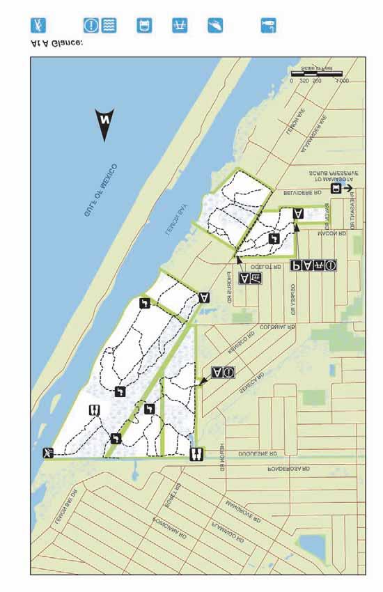
12 Locator Map Match the Map Reference numbers on the Locator Map to the At A Glance Guide on the left 12
13 Geocaching Swimming Horseback Riding Bicycling Camping Fishing Paddling Boating Birding Playground Picnicking Restroom Facility Public Transit Dogs Allowed Seasonal Flooding Interpretive Exhibit Barrier Free Access* Paved Trails Primitive Trails At A Glance Guide *Barrier free access limited to designated areas Sites Page Map # 1 16 Bayonne 2 18 Celery Fields and Palmer Gazebo 3 20 Circus Hammock 4 22 Old Miakka Preserve 5 24 Red Bug Slough Preserve 6 26 Rothenbach Park 7 28 Ted Sperling Park at South Lido Beach 8 30 Urfer Family Park 9 34 Deer Prairie Creek Preserve Jelks Preserve Snook Haven Park Sleeping Turtles Preserve North Sleeping Turtles Preserve South T. Mabry Carlton, Jr. Memorial Reserve 15 Oscar Scherer Buffer Scheduled to open in Eastern Ranchlands - Walton Ranch Recent Acquisition - Site plans to be developed in Caspersen Beach Curry Creek Preserve Lemon Bay Park and Environmental Center Manasota Scrub Preserve Myakka Islands Point Pocono Trail Preserve Shamrock Park and Nature Center South Venice Lemon Bay Preserve

14 Northern Region
15 15


16 8050 Springfield Dr, Sarasota, Size 11 acres Bayonne GPS Coordinates , About the Property Acquired in 2002, Bayonne protects important links to our past and unfolds a suburban retreat for day hikers and picnickers as well as several imperiled species. Named for an early development that was planned but never built, this site now preserves one of the last undeveloped areas of coastal scrub habitat north of Osprey in Sarasota County. The surrounding areas, once used by Native Americans, are now a bustling commercial and residential center. Directions and Parking From I-75 Exit 205 Clark Rd/FL-72 W. Travel west on Clark Rd/Fl-72 W for 3.1 miles. Turn left onto Beneva Rd, travel 2.5 miles. Turn right onto Tamiami Trail, travel 0.3 miles. Turn left onto Springfield Dr (portions unpaved). Parking is available at the adjacent church. The entrance is a short walk from the parking area. Restrooms and Water None available on site SCAT Bus Stop and Route Monday through Saturday - Route 17; Sunday - Route 1713 What Visitors Might See Gopher tortoises, grey squirrels, bald eagles, osprey, great horned owl, song birds, and an assortment of native plants including coontie, a variety of wildflowers, and all three types of scrub oaks Recreational Opportunities Hiking, Picnicking Approximately 1.5 miles of sandy, unpaved sunny trails with rest station benches. Trails are most comfortable during the cooler winter months Unmarked trails Some trails experience flooding seasonally and after heavy rainfall Nearby Recreation Lands Potter Park Legacy Trail Stoneybrook Nature Trail Watershed Little Sarasota Bay 16
17


18 Celery Fields and Palmer Gazebo 6799 Palmer Blvd, Sarasota, Size 450 acres GPS Coordinates , About the Property Acquired in 1995 and newly completed in May 2011, the Celery Fields and Palmer Gazebo is an important regional stormwater facility, handling stormwater runoff from approximately 3,500 acres of the upper Phillippi Creek Basin. Formerly celery fields, the created wetlands now help to improve water quality and provide important habitat. The area has gained renown as a favored site among birders. Surveys of the area conducted by the Sarasota Audubon Society have noted more than 200 species of birds. At 75-feet-tall, the observation mound affectionately known as Mt. Celery, allows visitors to enjoy expansive views of the landscape. Directions and Parking From I-75 Exit 210 Fruitville Rd/FL Travel east on Fruitville Rd for 0.7 miles. Turn left onto Coburn Rd, travel 0.7 miles. Continue onto Apex Rd, travel 0.4 miles. Turn left onto Palmer Blvd, travel 0.8 miles. Entrance is on the left, parking area is near the gazebo. Restrooms and Water None available on site at this time; Nearby restroom available at Fruitville Library, 100 Coburn Road; Future onsite restrooms planned SCAT Bus Stop and Route Monday through Saturday - Routes 1 and 1A What Visitors Might See A wide range of birds including herons, egrets, gulls, terns, anhinga, cormorants, limpkins, sparrows and wrens Recreational Opportunities Hiking, Picnicking, Playground, Birding, Fishing, Biking Approximately 9 miles sunny paved and unpaved trails with views of wetlands throughout Palmer Gazebo, named for Bertha Palmer Nearby Recreation Lands Urfer Family Park Nathan Benderson Park Colonial Oaks Park Watershed Roberts Bay North 18
19


20 Circus Hammock th St, Sarasota, Size 21 acres GPS Coordinates , About the Property Acquired in 2006, Circus Hammock is an urban preserve that protects a diverse assemblage of plants and provides a beautiful, peaceful green space in the midst of residential neighborhoods. Located near the historic winter quarters of the Ringling Brothers & Barnum and Bailey Circus, anecdotal evidence suggests that this area may have also been frequented by circus workers and performers. Follow their steps as you meander through the shady hammock of oaks, red maple, hackberry, and American elm. Directions and Parking From I-75 Exit 210 Fruitville Rd/FL Travel west on Fruitville Rd for 0.9 miles. Turn right onto Honore Ave, travel 1 mile. Turn left onto 17 th St, travel 1 mile. Turn left into 17 th Street Paw Park. Preserve entrance is on the right. Parking area is at 17 th Street Paw Park, on left, a short walk to the preserve's entrance. What Visitors Might See Woodpeckers, box turtles, redshouldered hawks, barred owls and an assortment of song birds Recreational Opportunities Hiking, Picnicking Approximately 1.5 miles of marked, unpaved, shady trails Most of the trails experience flooding seasonally and after heavy rainfall Nearby Recreation Lands Bobby Jones Golf Course 17th Street Park Nathan Benderson Park Watershed Sarasota Bay Restrooms and Water None available on site; Portable toilet available at adjacent 17th Street Park SCAT Bus Stop and Route Monday through Sunday - Route 6 20
21


22 Old Miakka Preserve 251 Myakka Rd, Sarasota, Size 132 acres GPS Coordinates , About the Property Acquired in 2006, Old Miakka Preserve is named after Old Miakka, the historic rural community where the preserve is located. As you experience the tranquil beauty of the Old Miakka preserve, enjoy the variety of plant life here that inspired Tim Cash ( ) a local nursery owner and founding member of the Serenoa Chapter of the Florida Native Plant Society, who was also active in the Old Miakka community. A trail, named in his honor, passes through subtle changes in habitat, allowing visitors to experience the natural diversity that Tim admired. Directions and Parking From I-75 Exit 210-Fruitville Road, travel east on Fruitville Road for approx 11.3 miles. Continue straight on the Fruitville Road Extension for.04 miles. Entrance is on the right, parking area just inside the entrance gate. Restrooms and Water None available on site SCAT Bus Stop and Route No routes available What Visitors Might See Gopher tortoises, swallowtail butterflies, song and wading type birds and an assortment of wildflowers, such as spiderwort and beautyberry Recreational Opportunities Hiking, Picnicking, Birding 4 miles unpaved, marked trails through systems of hammocks and seasonal wetlands, including the 1.5- mile Tim Cash Loop Trail Some of the trails experience flooding seasonally and after heavy rainfall including creek and ditch crossings Nearby Recreation Lands Myakka River State Park Watershed Myakka River 22
23


24 Red Bug Slough Preserve 5200 Beneva Rd, Sarasota, Size 72 acres GPS Coordinates , About the Property Acquired in 2000 and 2001 with funding assistance provided by Florida Communities Trust, Red Bug Slough Preserve is a small oasis of natural Florida in the midst of suburban Sarasota. The slough, named for the cotton stainer bug, flows through the preserve and forms a calm lake. Hiking and biking trails through the preserve are shaded by pines and palmettos that give way to oaks draped with Spanish moss. Before ending your visit, stop to rest on one of the park benches that overlook the lake. Directions and Parking From I-75 Exit 207 Bee Ridge Rd/FL- 758 W. Travel west on Bee Ridge Rd for 2.9 miles. Turn left onto Beneva Rd, travel 1.4 miles. Entrance is on the right, limited parking is available a short distance from a walk-through access. Restrooms and Water On site facilities to be completed in 2012 SCAT Bus Stop and Route Monday through Sunday - Route 6 What Visitors Might See Grey squirrels, marsh rabbits, river otters, an occasional alligator, song birds, and an assortment of wildflowers, such as partridge pea and frostweed Recreational Opportunities Hiking, Picnicking, Playground, Birding Approximately 2-miles marked, unpaved shaded and sunny trails with rest station benches viewing the slough Some of the trails experience flooding seasonally and after heavy rainfall Leashed dogs are allowed at the preserve Nearby Recreation Lands Bee Ridge Park Phillippi Estate Park Watershed Sarasota Bay 24
25


26 Rothenbach Park 8650 Bee Ridge Rd, Sarasota, Size 450 acres GPS Coordinates , About the Property Rothenbach Park is a closed and capped landfill which has been "recycled" into open vistas and a delightful public park, a prime example of turning trash into treasure! Named for Walter J. Rothenbach, Jr., a 40-year employee of Sarasota County who embraced nature as Director of Parks and Recreation for many years, this is a true community park offering many opportunities for recreational and nature based fun. Embracing sustainability, the park is home to the Florida Power and Light (FPL) solar array which provides electrical power to the FPL grid, one of the first in Southern Florida. The amenities include some of the most advanced recycling and sustainable building techniques and materials available. Directions and Parking From I-75 Exit Bee Ridge Rd. Travel east on Bee Ridge Road for 3 miles to the end. Follow park road to right to entrance, parking area is near playgrounds. Restrooms and Water Public restrooms and water available at the pavilion SCAT Bus Stop and Route No routes available What Visitors Might See White-tailed deer, American alligator, armadillo, meadowlarks, red-shouldered hawks, black-bellied whistling ducks, wood ducks, coots, moorhens, great blue herons, little blue herons, pileated woodpeckers, rabbits, red-bellied woodpeckers and downy woodpeckers Recreational Opportunities Hiking, Picnicking, Playgrounds, Biking Approximately 5-miles paved and unpaved sunny and shady trails with benches Mobility limited accessibility Picnic pavilion available for reservation, call for more information Nearby Recreation Lands Lakeview Park and Paw Park Watershed Sarasota Bay and Dona/Roberts Bay 26
27


28 Ted Sperling Park at South Lido Beach 2201 Ben Franklin Dr, Lido Key, Size 100 acres GPS Coordinates , About the Property Acquired in 1972 as part of the first major citizen-led acquisition initiative, this park is named for Ted Sperling, a former City of Sarasota commissioner and president of Save Our Bays, who led several campaigns for public acquisition of beach properties including the land at South Lido Beach. During the nineteenth century Lido Key consisted of a series of islands separated by shifting channels. In the early 1920 s the islands were purchased by John Ringling who greatly manipulated the shapes of the islands by moving millions of cubic feet of sand. Ringling named one of the newly created islands after the Italian word for beach, "lido." Occupying the southern tip of Lido Key, the park interacts with four bodies of water and offers a wide selection of experiences. Directions and Parking From I-75 Exit 210 Fruitville Rd. Travel west on Fruitville Rd for 6 miles. Turn left onto N Tamiami Trail, travel 0.2 miles. Turn right onto N Gulfstream Ave, travel 0.2 miles. Continue onto John Ringling Causeway which becomes John Ringling Blvd for 2.1 miles. At St. Armand s Circle, take the Lido Beach turn off the traffic circle to continue on John Ringling Blvd for 0.3 miles. Turn left onto Ben Franklin Dr, travel 1.5 miles to the entrance. Parking area is inside the gate. What Visitors Might See Shoreline and wading birds, coastal native plants like: seagrape, red and black mangrove, sea purslane, beach morning glory and sea oats Recreational Opportunities Hiking, Picnicking, Playground, Birding, Boating, Paddling, Fishing, Biking, Swimming, Beach Volleyball The southern portion of the park offers shaded nature trails and picnic area, beach access and wonderful water views The north end of the park includes a picnic area as well as access to the Lido Paddling Trail that winds through exotic mangrove tunnels Lifeguards on duty on weekends in the summer months Nearby Recreation Lands Lido Beach Ken Thompson Park Watershed Sarasota Bay Restrooms and Water Public facilities available SCAT Bus Stop and Route Monday through Saturday - Route 4 28
29


30 Urfer Family Park 4000 Honore Ave, Sarasota, Size 55 acres GPS Coordinates , About the Property Urfer Family Park highlights a unique combination of conservation, recreation, and learning opportunities per the vision of Jack and Thelma Urfer, the park s namesakes and benefactors. In addition to playgrounds for toddlers through teens and a 1-mile nature trail, the park is also home to a small working cattle ranch and the C. B. Wilson House, constructed circa The historic home provides space for park offices and public meetings. As Sarasota County s first Silver LEED certified park, Urfer Family Park represents a new milestone in sustainability and livability in a suburban setting. Directions and Parking From I-75 Exit Bee Ridge Rd. Travel west on Bee Ridge Rd for 0.9 miles. Turn left onto Honore Ave, travel 0.1 miles. Entrance is on the right., parking area is at the entrance. Restrooms and Water Public facilities available on site What Visitors Might See Cattle, deer, possum, raccoons, turtles, various snakes, birds, alligators and native plants Recreational Opportunities Hiking, Picnicking, Playgrounds, Bicycling Approximately 2 miles rated easy nature trail through diverse ecosystems including boardwalks over wetlands Picnic pavilion available for reservation, call for more information Nearby Recreation Lands Celery Fields and Palmer Gazebo Colonial Oaks Park Watershed Sarasota Bay SCAT Bus Stop and Route Monday through Saturday - Route14; Sunday - Route
31

32 Central Region
33 33


34 Deer Prairie Creek Preserve North: 7001 Forbes Trl, Venice, South: S Tamiami Trl, Venice, Size 6,439 acres GPS Coordinates North: , South: , About the Property Acquired between 2000 and 2004 through a partnership with the Southwest Florida Water Management District, Deer Prairie Creek Preserve helps protect the floodplain of the Myakka River, one of two rivers designated as Wild and Scenic. The preserve has a variety of native habitats, including pine flatwoods, prairie hammock and seasonal wetlands providing scenic overlooks along the banks of the Myakka River and Deer Prairie Creek. Directions and Parking North: From I-75 Exit Jacaranda Blvd. Travel north on Jacaranda Blvd for 0.9 miles. Turn right onto Border Rd, travel 2.6 miles. Turn right onto South Moon Dr, travel 1.6 miles. Turn left onto Forbes Trail, travel 1.1 miles. Entrance is on the right with a parking area able to handle horse trailers. South: From I-75 Exit N River Rd. Travel south-east on N River Rd for 5.5 miles. Turn left onto US-41 S. S Tamiami Trail, travel 1.1 miles. Make a U -turn at Lazy River Rd, travel 0.2 miles. Entrance is on right. Parking area is 1 mile into the preserve (unpaved). Restrooms and Water No facilities available on site; Water trough available for horses, near trail marker 144 SCAT Bus Stop and Route North: No routes available South: Monday through Saturday - Route 9; Sunday Route 9S 34 What Visitors Might See Gopher tortoises, alligators, river otter, wild turkey, swallow-tailed kite, Florida scrub-jays, wading birds, St. John s wort, tarflower and pine lily Recreational Opportunities Hiking, Picnicking, Birding, Paddling, Fishing, Bicycling, Horseback Riding Approximately 70 miles marked, unpaved trails through diverse habitats Horseback riding trails accessible ONLY from North entrance North entrance paddling access does not accommodate launching; Launch located near South entrance Nearby Recreation Lands T. Mabry Carlton, Jr. Memorial Reserve Jelks Preserve Snook Haven Park Watershed Myakka River
35


36 Jelks Preserve 2300 N River Rd, Venice, Size 614 acres GPS Coordinates , About the Property Acquired in 1999 with the generous support of the Jelks Family Foundation, Jelks Preserve borders the Wild and Scenic Myakka River, forever protecting a piece of the riverine floodplain. One can view the river at three different locations, while relaxing in the shade of mature live oak trees, festooned with epiphytes. While exploring the preserve s network of trails, visitors will traverse through a varied landscape of hammocks, pine flatwoods, and seasonal wetlands that unfolds glimpses of the river at key spots. While some trails may be cool as they stroll to the river through canopied hammocks, others may be open and sunny as they cross pine flatwoods. Directions and Parking From I-75 Exit N River Rd. Travel south-east on N River Rd for 1.4 miles. Entrance is on left, parking area located near entrance and walk-through access. What Visitors Might See Gopher tortoises, swallowtail butterflies and swallow-tailed kites, song birds and an assortment of wildflowers, such as Carolina jessamine and coralbean Recreational Opportunities Hiking, Picnicking, Birding, Fishing Approximately 8 miles marked, unpaved trails including a 3.3 mile outer loop trail through a diverse landscape Most of the trails experience flooding seasonally and after heavy rainfall Nearby Recreation Lands Snook Haven Park Sleeping Turtles Preserve South Deer Prairie Creek Preserve Restrooms and Water Portable toilet seasonally available on site Watershed Myakka River SCAT Bus Stop and Route No routes available 36
37


38 Snook Haven Park 5000 E Venice Ave, Venice, Size 2.5 acres GPS Coordinates , About the Property Acquired in 2006, Snook Haven park preserves a local gem of cultural heritage while increasing public access to the Wild and Scenic Myakka River. Snook Haven was established in 1948 as a fishing camp located along the Myakka River. Today, the park is popular for shoreline fishing, boat tours, kayak and canoe rentals and its riverfront restaurant known for live entertainment and old Florida charm. While not specifically a conservation land, Snook Haven Park offers visitors a unique opportunity to discover natural Sarasota in a different way. Directions and Parking From I-75 Exit N River Rd. Travel south-east on N River Rd for 0.7 miles. Turn left onto E Venice Ave, travel 0.5 miles. Slight left to stay on E Venice Ave, travel 0.1 miles to entrance. Parking areas can accommodate trailers and are a short walk to the river, restaurant, and boat launch. Restrooms and Water Public facilities available on site SCAT Bus Stop and Route No routes available What Visitors Might See Manatees, American alligator, various song birds and waterfowl Recreational Opportunities Picnicking, Boating, Paddling, Fishing A small launch fee applies to boats and kayaks that are on trailers; Launching is restricted at the boat ramp on Thursdays, Saturdays and Sundays. For more information, call For information about Snook Haven Riverfront Restaurant, entertainment, reservations, canoe rentals, and boat, kayak and canoe launching, call or visit Nearby Recreation Lands Deer Prairie Creek Preserve Sleeping Turtles Preserve South Jelks Preserve Watershed Myakka River 38
39


40 Sleeping Turtles Preserve North 3462 Border Rd, Venice, Size 174 acres GPS Coordinates , About the Property Acquired in 2003 and 2004, with the assistance of grant funding from Florida Communities Trust, Sleeping Turtles Preserve North provides multiple-use passive recreation opportunities and helps preserve the character and quality of the Wild and Scenic Myakka River. Named after a notation on an 1800 s navigation map of the river, the preserve s trails wind through floodplain swamps and pine flatwoods and offers views of the river where visitors might see sleeping turtles basking on fallen trees. Directions and Parking From I-75 Exit Jacaranda Blvd. Travel north on Jacaranda Blvd for 0.9 miles. Turn right onto Border Rd, travel 2 miles. Entrance is on the left, limited parking is located near the entrance. Restrooms and Water Portable toilet is available on site SCAT Bus Stop and Route No routes available What Visitors Might See Gopher tortoises, swallow-tailed kites, osprey, alligators and an assortment of song birds and waterfowl Recreational Opportunities Hiking, Picnicking, Birding, Bicycling 4.7 miles of marked, unpaved trails most of which experience flooding seasonally and after heavy rainfall Leashed pets are allowed only on the area north of Border Road Paddling access from the Myakka River does not accommodate launching Nearby Recreation Lands T. Mabry Carlton Jr., Memorial Reserve Watershed Myakka River 40
41


42 Sleeping Turtles Preserve South 2800 N River Rd, Venice, Size 213 acres GPS Coordinates , About the Property Acquired in 2002 with grant assistance from Florida Communities Trust, Sleeping Turtles Preserve South provides a buffer between the I-75 and River Road interchange and the Wild and Scenic Myakka River. The stretch of the river that parallels the preserve, was indentified on 1800 s navigation maps as Sleeping Turtles. Though none of the trails here lead to the river s high banks, the preserve offers natural beauty, intimate hiking trails and opportunities for waterfront picnicking and fishing, just off the interstate. Directions and Parking From I-75 Exit N River Rd. Travel south-east on N River Rd for 0.6 miles. Entrance is on the left, just before Venice Ave. Limited parking is available along the road shoulders. Walk-through accesses are located along the boundary near the northeast corner of the intersection of E Venice Ave and N River Rd and near the southeast corner of the intersection of N River Rd and the I-75 southbound entrance ramp. Restrooms and Water None available on site SCAT Bus Stop and Route No routes available What Visitors Might See Gopher tortoise, bobcat, sandhill cranes, swallow-tailed kites, osprey, and an assortment of wildflowers, such as false foxglove, blazing star, pennyroyal and spider lily Recreational Opportunities Hiking, Picnicking, Birding, Fishing, Bicycling 5.5 miles of marked, unpaved trails some of which experience flooding seasonally and after heavy rainfall Fishing and picnicking available at the pond Nearby Recreation Lands Snook Haven Park Jelks Preserve Watershed Myakka River 42
43


44 T. Mabry Carlton, Jr. Memorial Reserve 1800 Mabry Carlton Pkwy, Venice, Size 24,565 acres GPS Coordinates , About the Property Acquired between 1982 and 1984, the T. Mabry Carlton, Jr. Memorial Reserve encompasses an assortment of community values. The wetland-speckled expanses of pine flatwoods and dry prairies provide natural area conservation, unique wilderness recreation opportunities, cultural heritage preservation and public water supply protection. Named for Mabry Carlton, a former County commissioner and 5 th generation Florida cattleman who was instrumental in the reserve s acquisition, the reserve remains a hallmark of Sarasota s legacy of stewardship. Directions and Parking From I-75 Exit Jacaranda Blvd. Travel north on Jacaranda Blvd for 0.9 miles. Turn right onto Border Rd, travel 2.6 miles. Turn left onto Mabry Carlton Pkwy, travel 0.3 miles. Follow signs to public park area entrance and parking area on right. Restrooms and Water Public restrooms available near the parking area SCAT Bus Stop and Route No routes available What Visitors Might See White-tailed deer, cattle, wild turkey, bobcats, swallow-tailed kites, various wading birds and an assortment of wildflowers, such as pine lily, tarflower and blue flag iris Recreational Opportunities Hiking, Picnicking, Birding, Paddling, Fishing, Camping, Bicycling, Horseback Riding The public park area has parking, picnic tables, a visitor s cabin, and interpretive nature trails The back-country offers more than 80 miles of marked, unpaved trails including the 12 mile Myakka Island Wilderness Trail which continues north to Myakka River State Park Nearby Recreation Lands Deer Prairie Creek Preserve Sleeping Turtles Preserve North Watershed Myakka River 44
45


46 Southern Region
47 47


48 Caspersen Beach 4100 Harbor Dr, Venice, Size 177 acres GPS Coordinates , About the Property Acquired in 1972 and 1985, Caspersen Beach is a rare, natural undeveloped beach. Its name, that of the Caspersen family who originally leased the land to Sarasota County in 1968, is now wellknown for terrific shelling, prehistoric sharks teeth, and unspoiled beachfront. The southern two thirds of the nearly two miles of beachfront have been left in a natural state and dune walkovers help preserve the shoreline. Nestled between the Intercoastal Waterway and Lemon Bay to the east and the Gulf of Mexico on the west, Caspersen Beach highlights not only its trademark dark-sand beaches and dunes but also enclaves of coastal hammock and scrubby flatwoods that beckon visitors to explore. Directions and Parking From I-75 Exit State Hwy 681. Travel south on State Hwy 681 for 3.3 miles. Continue on to N Tamiami Trail, travel 3.4 miles. Turn right onto W Venice Ave, travel 0.4 miles. Turn left onto Harbor Drive S, travel 3.1 miles to entrance and parking area on the left, a short distance to the park s amenities. What Visitors Might See Florida scrub-jays, shoreline birds, raccoons, loggerhead sea turtles, and native dune plants Recreational Opportunities Hiking, Picnicking, Playground, Birding, Paddling, Fishing, Bicycling, Swimming More than two miles of trails including a unique boardwalk through coastal hammock Provides a trailhead for the Venetian Waterway Trail NO lifeguards on duty Nearby Recreation Lands Venetian Waterway Park Brohard Beach and Paw Park Venice Fishing Pier at Brohard Beach Watershed Dona/Roberts Bay Restrooms and Water Restrooms and water available on site SCAT Bus Stop and Route No routes available 48
49


50 Curry Creek Preserve East: 1500 Pinebrook Rd, Venice West: 1075 Albee Farm Rd, Venice, Size 80 acres GPS Coordinates East: , West: , About the Property Acquired in 2002 with grant assistance from Florida Communities Trust, Curry Creek Preserve protects rare coastal longleaf pine flatwoods while providing valuable open space for a growing community. The creek, which runs along the preserve s boundary, is one of the few remaining coastal creeks in southwest Florida and is named for the Curry family, early pioneers that settled the area. Hikers and paddlers will delight in the variety as scrub and pine flatwoods blend into tidal marshes and swamps along the creek s edge. Directions and Parking East: From I-75 Exit Laurel Rd E. Travel west on Laurel Rd E 0.3 miles. Turn left onto Pinebrook Road, travel 1.5 miles. Entrance is on the right, limited parking along easement. West: From I-75 Exit Laurel Rd E. Travel west on Laurel Rd E 1.3 miles. Turn left onto Albee Farm Rd N, travel 1.5 miles. Entrance and parking area are on the left, close to walk-through access and kayak launch. What Visitors Might See Gopher tortoises, alligators, river otters, eastern indigo snakes and an assortment of wading birds such as the roseate spoonbill and wood stork Recreational Opportunities Hiking, Picnicking, Birding, Paddling, Bicycling Just over 1.5 miles of marked, unpaved trails, that offer views of Curry Creek; Some trails may experience flooding seasonally and after heavy rainfall Kayak launch accessible from West entrance Nearby Recreation Lands Pinebrook Park Legacy Trail Pocono Trail Preserve Venice Train Depot Watershed Dona/Roberts Bay Restrooms and Water None available on site SCAT Bus Stop and Route No routes available 50
51


52 Lemon Bay Park and Environmental Center 570 Bay Park Blvd, Englewood, Size 208 acres GPS Coordinates , About the Property Acquired in 1986, Lemon Bay Park has helped preserve the pine and scrubby flatwoods and natural shoreline along Lemon Bay. Tucked in an urban location, the park also provides opportunities for outdoor recreation and environmental education. Directions and Parking From I -75 Exit Jacaranda Blvd. Travel south on Jacaranda Blvd toward CR 765/Englewood/Venice for 5.1 miles. Turn left onto FL-776/Englewood Rd, travel 4.1 miles. Turn right onto Old Englewood Rd, travel 1 mile. Slight right onto Kilbourne Ave, travel 0.2 miles. First right onto Morrison Ave, then first left on Curtis Blvd. Take first right on Brengle Ave. Entrance is ahead with parking near the Environmental Center. Restrooms and Water Public facilities and water available on site SCAT Bus Stop and Route A few blocks to bus stop. Monday through Saturday - Route 16 What Visitors Might See Gray fox, bobcats, river otters, raccoons, butterflies, and a variety of birds such as anhinga, bald eagle, snowy egret, and flycatcher frigate birds Recreational Opportunities Hiking, Picnicking, Birding, Paddling, Fishing, Bicycling Nearly 3.5 miles of marked, unpaved trails, with overlooks of Lemon Bay. Mobility limited accessibility Picnic pavilion and indoor meeting space available for reservations, call for more information Paddling launch available Nearby Recreation Lands Indian Mound Park Manasota Scrub Preserve Englewood Sports Complex Watershed Dona/Roberts Bay 52
53


54 Manasota Scrub Preserve 2695 Bridge St, Englewood, Size 145 acres GPS Coordinates , About the Property Acquired between 2000 and 2002 with grant assistance from Florida Communities Trust, Manasota Scrub Preserve is home to one of the remaining scattered pockets of scrub habitat. The preserve is named for this habitat and one of the earlier landowners, the Manasota Land and Timber Company. The preserve s system of trails and boardwalks offers picturesque views of a variety of upland and wetland habitats right within a suburban community. Unwind and enjoy nature on one of the benches that you will find along the trail. Directions and Parking From I-75 Exit Jacaranda Blvd. Travel south on Jacaranda Blvd toward CR 765/Englewood/Venice for 5.1 miles. Turn left onto Englewood Rd, travel 1.6 miles. Turn right onto Manasota Beach Rd, travel 0.2 miles. Turn left on Bridge St. Entrance is on the left with limited parking area and an ADA-compliant parking spot close to an accessible scenic boardwalk. What Visitors Might See Gopher tortoises, northern quail, swallowtail butterflies, great horned owls, and an assortment of wildflowers including grassleaf goldenaster and blazing star Recreational Opportunities Hiking, Picnicking, Birding Approximately 1.5 miles of unpaved, marked trails some of which experience flooding seasonally and after heavy rainfall Nearby Recreation Lands Manasota Beach South Venice Lemon Bay Preserve Shamrock Park and Nature Center Venice Area Audubon Rookery Watershed Lemon Bay Restrooms and Water None available on site SCAT Bus Stop and Route One block to bus stop. Monday through Saturday - Route 16 54
55


56 Myakka Islands Point 1289 Campbell St, Port Charlotte, Size 100 acres GPS Coordinates , About the Property Acquired in 2006, Myakka Islands Point is a highly productive and ecologically important site. The expansive tidal marsh that surround an island of upland flatwoods provides important habitat for wading birds and fish. Catching a glimpse of the Wild and Scenic Myakka River, it is easy to understand this region s historic associations with fishing, navigable waterways and Native American culture. Directions and Parking From I-75 Exit N River Rd. Travel south on N River Rd toward North Port for 5.5 miles. Turn left onto US-41 S/S Tamiami Trail, travel 4.1 miles. Turn right onto North Port Blvd, travel 0.8 miles. Turn right onto Chancellor Blvd, travel 1 mile. Chancellor Blvd turns left and becomes Campbell St, travel south on Campbell St 1.4 miles. Entrance is on the right, parking area is just inside entrance. Restrooms and Water None available on site SCAT Bus Stop and Route No routes available What Visitors Might See American kestrels, swallow-tailed kites, and a variety of wading birds and amphibians Recreational Opportunities Hiking, Birding Approximately 2 miles unpaved, marked trails with rest station bench areas sporting wonderful views of the Myakka River, a wonderful array of natural communities and areas rich with history Nearby Recreation Lands Myakka River State Park Marina Park Dallas White Park Watershed Myakka River 56
57


58 Pocono Trail Preserve 189 Pocono Trl, Nokomis, Size 8.2 acres GPS Coordinates , About the Property Acquired in 2002, Pocono Trail Preserve helps maintain the health of the Shakett Creek estuary system, and provides important habitat, open space and water access along a major urban corridor. The preserve is named for the street where it is located, Pocono Trail, which was originally named by Dr. Fred Albee, an early settler of Nokomis and owner of the Pollyanna Inn which, in 1922, was located on the land that is now the preserve. Today, the preserve s shady trails wind through maritime hammock and scrubby flatwoods and are punctuated by rest benches that offer charming views of the creek. Directions and Parking From I-75 Exit Laurel Rd. Travel west on Laurel Rd for 2.8 miles. Turn left onto US-41 S/N Tamiami Trl, travel south 1.7 miles. Turn left onto Colonia Ln, travel 0.3 miles. Take third left onto Pocono Trl E, travel 0.2 miles. Entrance will be on right. Very limited parallel parking is available along road shoulder next to the wood fence. Visitors are encouraged to park at Nokomis Community Center, a two block walk. Restrooms and Water Portable toilet and water available at Nokomis Community Center SCAT Bus Stop and Route Monday through Friday - Route 17 What Visitors Might See Gopher tortoises, osprey, grey squirrels, and an assortment of wading birds such as the little blue heron, snowy egret, white ibis and wood stork Recreational Opportunities Hiking, Picnicking, Birding, Fishing Approximately 1 mile of shady, unmarked, unpaved trails Nearby Recreation Lands Nokomis Community Park Legacy Trail Curry Creek Preserve Laurel Park Watershed Dona/Roberts Bay 58
59


60 Shamrock Park and Nature Center 3900 W Shamrock Dr, Venice, Size 80 acres GPS Coordinates , About the Property Shamrock Park and Nature Center balances a multiplicity of community values. The park provides opportunities for nature study, educational hikes, environmental programs as well as facilities for active recreation. However, it also serves as important habitat for Florida s only endemic bird, the Florida scrub-jay. As a trail head for the Venetian Waterway Trail the park supports a connected, active community and allows visitors to walk, bike or roller blade from Shamrock Park to downtown Venice, the historic train depot and Caspersen Beach. Directions and Parking From I-75 Exit 200 SR 681 South toward Venice traveling approx 3 miles to North Tamiami Trail/US 41. Turn left onto N. Tamiami Trail for approx. 2.7 miles to the Venice Bypass continuing approx. 3.2 miles to Shamrock Drive. Turn right on Shamrock Drive 1.7 miles to the park entrance on your right. Parking areas are a short walk to the Nature Center, park amenities and trails. Restrooms and Water Available on site at Nature Center SCAT Bus Stop and Route Monday through Saturday - Route 16; Sunday - Route 1713 What Visitors Might See Gopher tortoises, osprey, Florida scrubjay, and views of the Intercoastal Waterway Recreational Opportunities Hiking, Picnicking, Playground, Birding, Bicycling, In-line Skating, Tennis, Basketball About 3.5 miles of paved and unpaved, marked trails Trail head for the south east portion of the Venetian Waterway Trail A large recreation pavilion and indoor meeting space are available for reservation, call for more information Nearby Recreation Lands Venetian Waterway Park South Venice Lemon Bay Preserve Caspersen Beach Watershed Lemon Bay 60
61


62 South Venice Lemon Bay Preserve 6200 Osprey Rd, Venice, Size 225 acres GPS Coordinates , About the Property Acquired incrementally since 1999 with some grant assistance from Florida Communities Trust, South Venice Lemon Bay Preserve contains some of the last remaining undeveloped bay shorelines in the County. These lands protect the water quality and health of the Lemon Bay estuary, a State Aquatic Preserve for which it s named. Located in the suburb of south Venice, this preserve offers a peaceful retreat for visitors and a refuge for several protected animals and plants. Directions and Parking From I-75 Exit Jacaranda Blvd. Travel south on Jacaranda Blvd toward Englewood/Venice/Sarasota County for 5.1 miles. Turn left onto Englewood Rd, travel 1.6 miles. Turn right onto Manasota Beach Rd, travel 0.7 miles. Slight right onto Belvidere Rd, travel 0.3 miles. Turn right onto Pheasant Rd, travel 0.2 miles. Turn left onto Macon Rd, travel 0.2 miles. Turn left onto Osprey Rd. Entrance is just south of the intersection of Macon Rd and Osprey Rd, with limited parking and walkthrough access. Restrooms and Water None available on site SCAT Bus Stop and Route Several blocks to bus stop. Monday through Saturday - Route 13 What Visitors Might See Mangroves, cord grasses, oak species, lupine, palafox, coontie and Curtis s milkweed, gopher tortoises, Florida scrubjays, bald eagles, river otters and an assortment of snakes, including the eastern coachwhip Recreational Opportunities Hiking, Picnicking, Birding, Fishing Approximately 8 miles unpaved, marked trails including a 1.6 mile scenic trail Some trails experience flooding seasonally and after heavy rainfall Paddling access from Lemon Bay does not accommodate launching Nearby Recreation Lands Shamrock Park and Nature Center Manasota Scrub Preserve Woodmere Park and Paw Park Watershed Lemon Bay 62
63
 941-861-5000 scgov.")

64 Discover More of Natural Sarasota Other Places to Visit Sarasota County Government scgov.net Sarasota Convention & Visitors Bureau sarasotafl.org Discover Natural Sarasota discovernaturalsarasota.org Sarasota County Area Transit (SCAT) scgov.net/scat Florida Fish and Wildlife Conservation Commission (FWC) Nuisance Alligator Hotline 866-FWC-GATOR ( ) Recreational Fishing Licenses myfwc.com/license Wildlife Alert Hotline The Legacy Trail - Rails to Trails Venetian Waterway Park venicegov.com/park_links/venetian_waterway Oscar Scherer State Park floridastateparks.org/oscarscherer Myakka River State Park myakkariver.org Sarasota Blueways Guide sarasotabay.org/documents/sbnep_blueways_000.pdf Paddle Sarasota scgov.net/parksandrecreation/paddlesarasota/paddlesarasota.asp Boating and Angling Guide to Sarasota County scgov.net/environmentalservices/coastal/boatingguide.asp Artificial Reef Guide scgov.net/environmentalservices/coastal/artificialreef.asp In Case of Emergency Dial 911 For the latest updates, visit discovernaturalsarasota.org or scan this tag.
SARASOTA COUNTY Parks, Recreation and Natural Resources. Natural Areas Guide. Get off the beaten path
 SARASOTA COUNTY Parks, Recreation and Natural Resources Natural Areas Guide Get off the beaten path Get off the Beaten Path The goal of this guide is to help you discover a variety of ways to experience
Pinellas County Environmental Lands
 Pinellas County Environmental Lands In addition to traditional parks and recreation facilities, Pinellas County owns and manages a system of environmental lands that provides specialized resource-based
Conservation Lands. Conservation Lands Advisory Committee October 19, 2005
 Conservation Lands Advisory Committee October 19, 2005 Roland DeBlois Chief of Environmental Planning & Code Enforcement Community Development Department Beth Powell Conservation Lands Manager Parks Division
SARASOTA COUNTY Parks, Recreation and Natural Resources. Natural Areas Guide. Get o the beaten path
 SARASOTA COUNTY Parks, Recreation and Natural Resources Natural Areas Guide Get o the beaten path Get o the Beaten Path The goal of this guide is to help you discover a variety of ways to experience our
SOUTH WALTON TRAILWAYS
 SOUTH WALTON TRAILWAYS 13 14 15 10 1 2 11 12 3 5 6 4 3 7 9 8 Nestled throughout Walton County are 200 miles of hiking and biking trails winding through state forests, state parks and public-private greenways.
proof Northwest District
 1 Northwest District The Northwest Florida Water Management District is the most rural of all five water management districts. From just east of Tallahassee west to the Florida/Alabama line, and from the
IOWA ORNITHOLOGISTS' UNION - Birding Sites in Dallas County
 IOWA ORNITHOLOGISTS' UNION - Birding Sites in Dallas County Printed on 7/19/2018 Beaver Bottoms Wetland (restricted) (Important Bird Area) GPS Coordinates:, Ownership: Private (see directions for access)
Lake Myra County Park. Wake County, North Carolina Community Forum #2 June 12, 2008
 Lake Myra County Park Wake County, North Carolina Community Forum #2 June 12, 2008 Welcome and Introduction Meeting Agenda Welcome Introductions of Project Team Master Plan Process Community Forum #1 Updates
A Vision for South Skunk River and Chichaqua Bottoms Greenbelt
 A Vision for South Skunk River and Chichaqua Bottoms Greenbelt Photo: Jim Pease Chichaqua Bottoms Booklet 7 of 8 Greater Des Moines Water Trails and Greenways 1 2016 Table of Contents Booklet 1: Water
2. Goals and Policies. The following are the adopted Parks and Trails Goals for Stillwater Township:
 D. PARKS AND TRAILS 1. Introduction Stillwater Township s population is relatively low, with most residents living on rural residences on large lots. The need for active park space has been minimal in
KETTLE CREEK CONSERVATION AUTHORITY TRAIL GUIDE.
 KETTLE CREEK CONSERVATION AUTHORITY TRAIL GUIDE www.kettlecreekconservation.on.ca EXPLORE OUR TRAILS HIKE OUR TRAILS Kettle Creek Conservation Authority (KCCA) proudly supports and promotes an active lifestyle
Comanche National Grassland, Timpas Unit
 Comanche National Grassland, Timpas Unit Heritage Resources More than 540 sites are eligible for listing on the National Register of Historic Places (NRHP) by Forest Service staff and/or the Colorado State
Bratt ") 4. % F l o r i d a D e s i g n a t e d P a d d l i n g T r a i l s ") 164 «97 ") 99. Barrineau Park. M a p 1. M a p 2.
 4. % F l o r i d a D e s i g n a t e d P a d d l i n g T r a i l s ) 164 «97 ) 99. Barrineau Park. M a p 1. M a p 2.") F l o r i d a D e s i g n a t e d P a d d l i n g T r a i l s Bratt ") 4 Bluff Springs «4 Jay ") P e r d i d o R i v e r P e r d i d o CR R99A i v Walnut e r Hill ") 164 ") 97A «89 «97 ") 197 Barrineau
F l o r i d a D e s i g n a t e d P a d d l i n g T r a i l s Bratt ") 4 Bluff Springs «4 Jay ") P e r d i d o R i v e r P e r d i d o CR R99A i v Walnut e r Hill ") 164 ") 97A «89 «97 ") 197 Barrineau
Sarasota County Trails Master Plan i
 Cover Page Table of Contents Table of Figures... ii List of Tables... ii 1.0 Introduction... 1 1.1 Why Build Trails?... 1 1.2 Relationship to the Statewide Trail System... 4 1.3 Trail Typologies... 5 1.4
CREW Cypress Dome Trails Self-Guided Tour
 CREW Cypress Dome Trails Self-Guided Tour The numbers in this guide correspond to numbers on the Cypress Dome Trail Map (included in this guide below) and to the brown number plates fastened to marker
Chapter eight. Parks and Recreation. Introduction. Crystal Lake Park District
 Chapter eight Parks and Recreation Introduction One of the indicators of quality of life in a city is the parks and recreation system. The City of Crystal Lake is fortunate to have an excellent parks and
Segment 2: La Crescent to Miller s Corner
 goal of the USFWS refuges is to conserve, protect and enhance fish, wildlife and plants and their habitats for the continuing benefit of the American people. Refuge lands are used largely for fishing,
SOUTH SECTION TRAIL SITES as of Mon Oct
 SOUTH SECTION TRAIL SITES as of Mon Oct. 16 2017 Partial Site is open but some hiking trails/facilities may be closed Closed Site is closed until further notice Open Site is open Unknown We have no information
Camping (Primitive) Camping (RV) Electrical Potable Water Grill Established Fire Pit Picnic Table
 Camping (RV) Electrical Potable Water Grill Established Fire Pit Picnic Table") Alden - 9th Road River Mile 777 Map: 38.20833, -98.32031 Managing Agency: Kansas Department of Wildlife, Parks & Tourism Nearest Community: Alden, Rice County Kansas Developed Amenities Provided Parking
Alden - 9th Road River Mile 777 Map: 38.20833, -98.32031 Managing Agency: Kansas Department of Wildlife, Parks & Tourism Nearest Community: Alden, Rice County Kansas Developed Amenities Provided Parking
STORNETTA BROTHERS COASTAL RANCH
 STORNETTA BROTHERS COASTAL RANCH Location: Surrounding Point Arena Lighthouse and immediately south of Manchester State Park Mendocino Co., CA Acres: 1,860 Resources: Over two miles of Pacific Ocean coastline
WATER PETALUMA TRAIL WATER WAYS PROJECT PORTFOLIO. petalumawaterways.org OVERVIEW
 WATER TRAIL PROJECT PORTFOLIO OVERVIEW Thirteen miles upstream of San Pablo Bay, Petaluma is the northern point on the San Francisco Bay Water Trail, a network of access points throughout the region. Most
Wilds. Headwaters. Lakes. Oxbows. Falls
 56 5 4 3 Wilds Headwaters Lakes Oxbows Falls 57 Zones It could be said the on-the-ground essence of this master plan appears within the next 6 pages of this report. As we learned in the preceding Cultural
Acquisition in fee simple of approximately one-half acre of property on the shore of Spring Lake to expand the Lakeside Beach Park.
 Lakeside Beach TF00-136 $122,550.00 in fee simple of approximately one-half acre of property on the shore of Spring Lake to exp the Lakeside Beach. 2000 River Ravines TF00-150 $910,000.00 in fee simple
Niagara Natural Heritage Park
 A Future Proposal For the Niagara-on-the-Lake DND Lands....... Parks Canada Lakeshore Road Property 1 May, 2016 The Harmony Residents Group We are proposing a Natural Heritage Park be established on the
Welcome to Seabrook Island. Seabrook Yesterday. And Today. The Horizon Plan
 Welcome to Seabrook Island There are few places left where the outside world rarely intrudes. You ve just found one of them. Only minutes from Charleston, SC, Seabrook Island s 2,200 acres stands as a
SECTION 4. PUBLIC RECREATION
 SECTION 4. PUBLIC RECREATION Brooker Creek Preserve is the largest remaining tract of wild land in Pinellas County and contains many species not found anywhere else in the County. As such, these wild lands
TAYLOR CANYON RANCH COLORADO - ROUTT COUNTY - STEAMBOAT SPRINGS
 TAYLOR CANYON RANCH COLORADO - ROUTT COUNTY - STEAMBOAT SPRINGS Tucked up against the steep valley shaped by Mt. Pau and rising to the Routt National Forest, Taylor Canyon Ranch is an easily accessible,
City of Durango 5.8 FUNDING TRAILS DEVELOPMENT
 5.8 FUNDING TRAILS DEVELOPMENT The City has been successful in establishing dedicated local funding sources as well as applying for grants to develop the City s trail system, having received nearly $2.4
Chapter 2: Summary of Existing Open Space System
 Chapter 2: Summary of Existing Open Space System In 1976, the Wake County Board of Commissioners established the Wake County Parks and Recreation Department in order to provide park facilities and programs
Blueways Paddling Guide
 SARASOTA COUNTY Parks, Recreation and Natural Resources Blueways Paddling Guide Get into the flow i Jacaranda Boulevard LONGBOAT KEY New Pass The numbered triangles identify the paddle trail areas in this
Florida Department of Environmental Protection Division of Recreation and Parks
 Florida Department of Environmental Protection Division of Recreation and Parks Land Edward Ball Wakulla Springs State Park Introduction Edward Ball Wakulla Springs State Park is a 6,055.2-acre public
Brooker Creek Preserve Management Plan 2008 Update
 Brooker Creek Preserve Management Plan 2008 Update Plan approved by the Board of County Commissioners Pinellas County, Florida 19 August 2008 Pinellas County Department of Environmental Management Environmental
The Sand Ridge - Tulare Lake Conservation Report proposes the following recommendations:
 Introduction Creighton Ranch. Pixley National Wildlife Refuge. Allensworth State Historic Park. Sand Ridge. Deer Creek. Located in the Tulare Lake Basin, the Sand-Ridge - Tulare Lake Planning Area features
Silver Lake Park An Environmental Jewel for the Citizens of Prince William County
 Silver Lake Park An Environmental Jewel for the Citizens of Prince William County The Prince William Park Authority Mission Statement states: The Prince William County Park Authority will create quality
Yuba Creek Natural Area Acquisition. Acme Township. Acme Township. TF Acquisition $1,576, Grand Traverse
 Yuba Creek Natural Area TF00-162 $1,576,021.00 in fee simple of 403 acres of critical wetls upl habitat with over 5,000 feet of frontage on Yuba Creek, a tributary to the east arm of Bay. 2000 Petobago
5 FAVORITE CENTRAL FL PARKS FOR OUTDOOR ACTIVITIES. Rockon Recreation Rentals
 Check out this Awesome Compilation of Southern Central Florida State Parks, where amateurs to experienced folks are welcome to explore the outdoors. 5 FAVORITE CENTRAL FL PARKS FOR OUTDOOR ACTIVITIES LAKE
Our Mission. Discover the many states of California. Chino Hills State Park 1879 Jackson Street Riverside, Ca (951)
") Chino Hills State Park Our Mission The mission of the California Department of Parks and Recreation is to provide for the health, inspiration and education of the people of California by helping to preserve
Chino Hills State Park Our Mission The mission of the California Department of Parks and Recreation is to provide for the health, inspiration and education of the people of California by helping to preserve
Map 1.1 Wenatchee Watershed Land Ownership
 Map 1.1 Wenatchee Watershed Land Ownership Map 1.1 Wenatchee Watershed Land Ownership The Wenatchee watershed lies in the heart of Washington state in Chelan County. Just larger than the state of Rhode
3.0 EXISTING PARK & RECREATION SPACE
 3.0 EXISTING PARK & RECREATION SPACE TOWN PARK & RECREATION SPACE An inventory of current parks and recreation area in the Town of Cedarburg is shown in Table 3. These areas total roughly 381.89 acres.
This Passport: Revised October 20, 2017, EAM # Discovering the Trails of Penfield, NY
 This Passport: Revised October 20, 2017, EAM #161922 Discovering the Trails of Penfield, NY The Town of Penfield is fortunate to have a wide variety of natural resources which make for many unique and
Field Guide. Nature Nearby. Traverse City
 Field Guide Nature Nearby Traverse City FEATURED PROPERTIES 1 DEEPWATER POINT NATURAL AREA 2 HICKORY MEADOWS NATURAL AREA KALKASKA 3 MAPLE BAY NATURAL AREA E as t A rm G r a n d Tr a v er s e B ay 4 PELIZZARI
City of Keller Parks and Facilities Inventory
 City of Keller Parks and Facilities Inventory April 2013 1. BEAR CREEK PARK 44 ACRES 1 Basketball Court with 2 goals 4 Drinking Fountains 1 Large Pavilion with 4 picnic tables, electricity and fireplace
Cuyahoga Valley National Park Ohio
 Cuyahoga Valley National Park Ohio Brandywine Falls The Ledges The Beaver Marsh Temperate Deciduous Forest How To Get There... Located between Cleveland & Akron, Ohio Cuyahoga Valley National Park can
EXECUTIVE SUMMARY PROGRAM DEVELOPMENT REPORT PURPOSE EXISTING SETTING EXPANDING PARKLAND
 EXECUTIVE SUMMARY PROGRAM DEVELOPMENT REPORT PURPOSE As the culmination of the first phase of the master planning process, this Program Development Report creates the framework to develop the Calero County
Northeast Quadrant Distinctive Features
 NORTHEAST QUADRANT Northeast Quadrant Distinctive Features LAND USE The Northeast Quadrant includes all the area within the planning area that is east of Interstate 5 and to the north of State Route 44.
St. Christopher Camp and Conference Center s Outdoor education program for elementary and middle school students
 St. Christopher Camp and Conference Center s Outdoor education program for elementary and middle school students Since 1980, The Barrier Island Environmental Education Program has provided thousands of
AGENDA ITEM 5 D WAKULLA ENVIRONMENTAL INSTITUTE (WEI) TRAIL FEASIBILITY STUDY
 TRAIL FEASIBILITY STUDY") March 19, 2018 AGENDA ITEM 5 D WAKULLA ENVIRONMENTAL INSTITUTE (WEI) TRAIL FEASIBILITY STUDY TYPE OF ITEM: Action STATEMENT OF ISSUE The Wakulla Environmental Institute (WEI) Trail is one of several trails
March 19, 2018 AGENDA ITEM 5 D WAKULLA ENVIRONMENTAL INSTITUTE (WEI) TRAIL FEASIBILITY STUDY TYPE OF ITEM: Action STATEMENT OF ISSUE The Wakulla Environmental Institute (WEI) Trail is one of several trails
Florida Department of Environmental Protection Division of Recreation and Parks
 Florida Department of Environmental Protection Division of Recreation and Parks Land Honeymoon Island State Park Introduction Honeymoon Island State Park is a 2,810.16-acre public outdoor recreation and
566± acres total - WILL DIVIDE Volusia County, FL
 L IC E N S E D HUNTING P RESERVE ts Q u a i l ahi ul anb l e are av r info! fo CALL TODAY LAKEFRONT PROPERTY PERFECTION This ranch lies on a natural sand ridge in North Volusia County, Florida and has
The Croatan MST Segment 16B
 1 Mountains-to-Sea Trail Last Updated 1/1/2017 A sandy road through longleaf pine savanna in the Croatan National Forest Photo by PJ Wetzel, www.pjwetzel.com The Croatan MST Segment 16B STELLA TO THE NEUSIOK
Cross Florida Beach to Beach Adventure Bicycle Route
 Cross Florida Beach to Beach Adventure Bicycle Route 240 Miles from Juno Beach to Venice Beach This document can be viewed and downloaded from the Cross Florida Adventure Bicycle Route tab at www.bikeveniceflorida.com
Welcome to Marco Island
 Marco Island is located in Southwest Florida, on the Gulf of Mexico, 178 miles south of Tampa,16 miles south of Naples, and 104 miles due west of Miami. Marco is the northern most and largest of the famous
Municipal Park Descriptions: 1. Bear Hollow Park 4100 Bear Hollow Park Court, Murrysville, PA acres
 MUNICIPAL PARK DESCRIPTIONS Murrysville has a wide variety of parks and recreational facilities including sports fields, neighborhood parks, community parks, a Community Center, and extensive natural areas
THE PINELLAS COUNTY PLANNING DEPARTMENT
 Guide to Pinellas County Blueways Prepared by THE PINELLAS COUNTY PLANNING DEPARTMENT December, 2006 Revised April, 2010 P inellas County has miles of beautiful shoreline, providing paddlers with a variety
2009 RIVER TOWN OF THE YEAR AWARD APPLICATION Supplemental Material Images
 2009 RIVER TOWN OF THE YEAR AWARD APPLICATION Supplemental Material Images Our History The earliest record of settlement along the river is in 1854; one of the earliest in Carroll County. About this time
BRACEVILLE NATURE PRESERVE Introductions History Present Conditions Future Development Plans Implementation Strategies Statistics
 BRACEVILLE NATURE PRESERVE Introductions History Present Conditions Future Development Plans Implementation Strategies Statistics Introduction Braceville Nature Preserve is one of MetroParks largest preserves.
Explore your Town With The Kingston Area Trail Passport
 Explore your Town With The Kingston Area Trail Passport Don t forget to stop at the children's room in the library for your prize when you collect 5 Passport Stamps! For more natural resource related information,
Delaware Wildlife Area
 Delaware Wildlife Area 8 miles away from Delaware 4,670 acre Wildlife Area 1) Take Rt. 36/East Williams Street eastward 2) Take left onto Rt. 42/Lake Street 3) Slight left onto Horseshoe Rd./CR. 220 4)
BACK COUNTRY UNIT PREFERRED ALTERNATIVE
 BACK COUNTRY UNIT PREFERRED ALTERNATIVE San Francisco (118 mi) Carmel-By-The-Sea Carmel River Carmel Valley Road State Beach Private Property Point Lobos State Reserve Point Lobos Ranch RUSTIC CAMPING
PALO CORONA REGIONAL PARK MPRPD BOARD MEETING AUGUST 8, 2018
 PALO CORONA REGIONAL PARK MPRPD BOARD MEETING AUGUST 8, 2018 ACKNOWLEDGEMENTS AGENCIES AND ORGANIZATIONS The Trust for Public Land Big Sur Land Trust Santa Lucia Conservancy California State Parks Point
Wetlands Reservoirs of Biodiversity. Billy McCord, SCDNR
 Wetlands Reservoirs of Biodiversity Billy McCord, SCDNR Estuaries Tidal Deepwater Intertidal Salt Marsh Tidal Riverine Fresh & Brackish Deepwater Tidal Emergent Marsh Freshwater Riverine Seasonally Flooded
Maine RV Parks and Campgrounds
 1 Maine RV Parks and Campgrounds Wilderness Edge Campground Brief Description: We are located in the heart of Moose country just minutes from Baxter State Park, Mt. Katahdin, and The Katahdin Woods & Waters
Stephens Rd. Nature Preserve
 Stephens Rd. Nature Preserve History Stephens Road Nature Preserve (SRNP) is a 350-acre nature preserve in Huntersville that comprises nine properties purchased between 1994 and 2008. Parcels included
TENKILLER STATE PARK -An Overview-
 TENKILLER STATE PARK -An Overview- - 0 - TENKILLER STATE PARK Region: Northeast (Green Country) Cherokee & Sequoyah Counties CONTENTS General Information. 2 Addresses Driving Directions Phone Numbers Email
City of Oak Harbor Parks & Descriptions
 City of Oak Harbor Parks & Descriptions North West Section Koetje Park - NE 7 th Avenue (3.5 acres) Neighborhood and Community Park with playgrounds on one tot lot, one soccer/practice field, picnic tables,
BA Collaborators. Driftless Area Initiative The Prairie Enthusiasts Trout Unlimited TNC TCF Natural Resources Foundation of Wisconsin
 BA Collaborators Driftless Area Initiative The Prairie Enthusiasts Trout Unlimited TNC TCF Natural Resources Foundation of Wisconsin The mission of the of the Blufflands Alliance is to actively conserve
Baltimore County Nature Quest NEW TRAILS 2014
 Baltimore County Nature Quest NEW TRAILS 2014 Nature Quest Park Locations Robert E. Lee Park Cromwell Valley Park Agricultural Ctr. & Farm Park Honeygo Regional Park Marshy Point Park and Nature Center
This Passport: Revised October 20, 2017, EAM # Discovering the Trails of Webster, NY
 This Passport: Revised October 20, 2017, EAM #161923 Discovering the Trails of Webster, NY The Town of Webster invites you to explore and experience our diverse outdoor adventures! Here s your opportunity
Topsham Trail Guide.
 Topsham Trail Guide A guide to the walking, hiking, biking, water and ATV trails of Topsham, Maine and surrounding towns $4.95 Developed by the www.greatertopshamtrailalliance.org The Greater Topsham Trail
Flow Stand Up Paddle Board Parkway Plan Analysis
 Regional Parks Department Jeffrey R. Leatherman, Director County of Sacramento Divisions Administration Golf Leisure Services Maintenance Rangers Therapeutic Recreation Services Flow Stand Up Paddle Board
March Hello everyone,
 Hello everyone, March 2015 Our first trip of 2015 found us at the Santee National Wildlife Refuge. It was sunny most of the day with highs in the low 50s and a steady breeze that made it feel much cooler.
Conservation Area Management Statement
 Conservation Area Management Statement Miller Creek Wildlife Area Resolution #: Approval: Issue Date: Date of Last Revision: Table of Contents 1. Purpose....... 1 2. Property Description...... 1 2.1. Legal
DeGray Lake Resort State Park
 Your Group at DeGray Lake Resort State Park BISMARCK, ARKANSAS WWW.DEGRAY.COM Welcome to DeGray Lake Resort State Park DeGray Lake Resort State Park is remote within reach. Conveniently located just one
FLORIDA DEPARTMENT OF ENVIRONMENTAL PROTECTION DIVISION OF RECREATION AND PARKS RECREATIONAL CARRYING CAPACITY GUIDELINES
 FLORIDA DEPARTMENT OF ENVIRONMENTAL PROTECTION DIVISION OF RECREATION AND PARKS RECREATIONAL CARRYING CAPACITY GUIDELINES THE SELECTION AND CAPACITY DETERMINATION OF USE SITES Introduction The Division
Non-motorized Trail Plan & Proposal. August 8, 2014
 Town of Star Valley Ranch, Wyoming and the Star Valley Ranch Association in partnership with the USDA Forest Service, Bridger-Teton National Forest, Greys River Ranger District Non-motorized Trail Plan
BIRDING Lake Fayetteville
 BIRDING Lake Fayetteville Lake Fayetteville is an impoundment of Clear Creek, created as a water supply for Fayetteville in 1949. With development of other water supplies, especially Beaver Lake, Lake
RIDGEFIELD PARKS February 2016
 RIDGEFIELD PARKS February 2016 Hayden Park Neighborhood Park Amenities Sign with Name of Park and City of Ridgefield Logo Lamp Post Parking Area Play Set Swings Sign with Playground Rules Durable Benches
Morgan Estates. Lassen County, CA. Proudly Offered By
 Morgan Estates Lassen County, CA Proudly Offered By 707 Merchant Street, Suite 100, Vacaville, Ca 95688 (707) 455-4444 Office (707) 455-0455 Fax info@caoutdoorproperties.com Introduction Looking North
San Francisco Bay Area Water Trail Site Description for. Suisun City Marina. Launch ramps and docks Suisun Channel Parking Lot
 1 San Francisco Bay Area Water Trail Site Description for Suisun City Marina Location, Ownership, and Management: Suisun City Marina is located on Kellogg St., approimately a half mile from Suisun City's
Appendix 3. Greenway Design Standards. The Whitemarsh Township Greenway Plan
 Appendix 3 Greenway Design Standards This chapter discusses two design standards for the greenway types discussed above. First, trail design standards are presented together with trailhead facilities and
Langton Lake Park Implementation Planning Session One 6 June Attendees signed in
 27 Attendees signed in Meeting summary Following an overview of the Parks and Recreation Renewal Program and the key directions of the Parks and Recreation System Master Plan, meeting participants were
Wool Ranch 20 Acres 20 +/- acres Sunol, CA Alameda County
 Wool Ranch 20 Acres 20 +/- acres Sunol, CA Alameda County 707 Merchant Street Suite 100 Vacaville, CA 95688 707-455-4444 Office 707-455-0455 Fax californiaoutdoorproperties.com CalBRE# 01838294 Introduction
Whitemouth Falls Provincial Park. Draft Management Plan
 Whitemouth Falls Provincial Park Draft Management Plan Whitemouth Falls Provincial Park Draft Management Plan Table of Contents 1. Introduction... 3 2. Park History... 3 3. Park Attributes... 4 3.1 Natural...
Nature is for everyone to enjoy, so let your followers experience the beauty.
 POCKET GUIDE WHILE YOU RE HIKING For your safety, please watch for loose rocks, tree roots, and other obstacles along the trails. Please park in designated parking areas only. Stay on the marked trail;
For more information, contact the UPF Marketing Department: (352) x 232
 x 232") WHAT PEOPLE ARE SAYING A revelation for hikers. Mashour knows the backcountry of Florida like few others. Robert Silk, author of An Ecotourist s Guide to the Everglades and the Florida Keys Provides detailed
WHAT PEOPLE ARE SAYING A revelation for hikers. Mashour knows the backcountry of Florida like few others. Robert Silk, author of An Ecotourist s Guide to the Everglades and the Florida Keys Provides detailed
Centred Outdoors is an open invitation for people of all ages and fitness levels to explore ten outdoor destinations in Centre County, Pennsylvania,
 Centred Outdoors is an open invitation for people of all ages and fitness levels to explore ten outdoor destinations in Centre County, Pennsylvania, throughout the summer of 2018. Together, we ll stress
Cataloochee. Fishing Species Rainbow Trout and Brook Trout. Recreation
 Cataloochee River Information The Cataloochee River is located in the historic Cataloochee Valley--a relatively remote part of Smoky Mountain National Park. The campground is a secluded setting and offers
CITY OF MANVEL Parks & Recreation Master Plan Community Meeting Summary
 CITY OF MANVEL Parks & Recreation Master Plan Community Meeting Summary The City of Manvel hosted a Community Meeting on June 23, 2016 at the Church of the Harvest. Over 25 community members attended and
Header i
 Header i 048285014.10 Header Sub Title Body Text here. Body text here. Body text here. Section 1... 1 Executive Summary... 1 Opportunities and Constraints... 3 Overall Opportunities and Constraints Map
$866,000. $1,400,000 Health Benefits $13,156,000 TOTAL ANNUAL DIRECT BENEFITS. $10,890,000 Economic Benefits
 SINGING RIVER TRAIL Trails Create Value + Generate Economic Activity Trails generate economic returns through improved health, safety, and environmental conditions, raise property values, and attract visitors.
Lewis and Clark Recreation Area
 Lewis and Clark Recreation Area Bicycle/Pedestrian Trail Also part of the Pierson Ranch Recreation Area trail Type of trail: Walking, biking and rollerblading Trail surface: Asphalt Rated: Mostly flat.
Classifications, Inventory and Level of Service
 Classifications, Inventory and Level of Service Section 3 Kenmore Park, Recreation and Open Space Plan 1 P a g e Classifications and Inventory Park Classifications Kenmore classifies its parks based upon
MONTGOMERY TOWNSHIP OPEN SPACE & PATHWAYS COMMITTEE
 MONTGOMERY TOWNSHIP OPEN SPACE & PATHWAYS COMMITTEE Meetings: 2 nd Wednesday of each month @ 6:30 PM in the Municipal Building Questions? Call the Open Space Coordinator, Lauren Wasilauski, at (908) 359-8211
MCARTHUR SWAMP PLANNING UNIT Pit-McCloud River Watershed
 Existing Conditions & Uses Overview Spring-fed lake and rivers; valuable grazing lands and important waterfowl area Planning unit provides the only public access to Ahjumawi Lava Springs State Park 7,596
Deering Estate Camp. Field Trip total: $ 5.00 Monday Tuesday Wednesday Thursday Friday. Campers will explore
 Discover Deering Campers will dive into the mission of the Deering Estate which is dedicated to preserving and protecting the natural, archaeological, architectural and historic legacy of the land. WEEK
THE PANTHER S ROAR PO BOX 51 CASHIERS, NC (828) 269-HIKE
 269-HIKE") Friends of Panthertown The Panther s Roar Panthertown Valley WNC THE PANTHER S ROAR PO BOX 51 CASHIERS, NC 28717 WWW.PANTHERTOWN.ORG (828) 269-HIKE Friends of Panthertown News Everybody needs beauty as
Friends of Panthertown The Panther s Roar Panthertown Valley WNC THE PANTHER S ROAR PO BOX 51 CASHIERS, NC 28717 WWW.PANTHERTOWN.ORG (828) 269-HIKE Friends of Panthertown News Everybody needs beauty as
Guide to Local Activities
 Guide to Local Activities We welcome you to Naples and the Vineyards! Naples is a wonderful place to visit and live. Our coast has everything you can possibly want from pristine beaches and island getaways
Roduner Ranch FOR SALE. 5,878± Acres Potential Development Land. Merced County, California. Offices Serving The Central Valley
 FOR SALE 5,878± Acres Potential Development Land Merced County, California Offices Serving The Central Valley F R E S N O V I S A L I A B A K E R S F I E L D 7480 N. Palm Ave, Ste 101 3447 S. Demaree Street
Port Gamble Shoreline Area Conceptual Trail Proposal
 The North Kitsap Trails Association is pleased to be a partner to the Kitsap Forest and Bay Project and assist Kitsap County, Forterra, Olympic Property Group, Great Peninsula Conservancy and the Port
Education Programs Duck Mountain Provincial Park
 Education Programs Duck Mountain Provincial Park 2018 Programs Bring your class to our outdoor classroom! Guided school programs are offered during the spring in Duck Mountain Provincial Park. Booking: