Sarasota County Trails Master Plan i
|
|
|
- Morgan Daniel
- 5 years ago
- Views:
Transcription
1 Cover Page
2 Table of Contents Table of Figures... ii List of Tables... ii 1.0 Introduction Why Build Trails? Relationship to the Statewide Trail System Trail Typologies Public Involvement Vision, Mission and Goals Existing Conditions Existing Plan Review Trail Inventory Premier Trails in Sarasota County Sarasota Blueways Trail Incident Analysis Recommendations Trail Recommendations Trail Analysis and Prioritization Trail Enhancement Recommendations Blueway and Other Recommendations Conclusions Implementation Strategy Appendices Appendix A. Prioritization Analysis Results Appendix B. Trail Design Guidelines Appendix C. Safety and Maintenance Plan Appendix D. Public Input Process Results Appendix E. Summary of Map Data Appendix F: Chapter 3 References Sarasota County Trails Master Plan i
3 Table of Figures Figure 1. Statewide Trail Systems... 4 Figure 2. Existing trails in Sarasota County (North) Figure 3. Existing Trails in Sarasota County (South) Figure 4. Bicycle And Pedestrian Crashes From Figure 5. Crimes Near Existing Sarasota County Trails Figure 6. Recommended Trails (Overall) Figure 7. Recommended Trails (Inset 1) Figure 8. Recommended Trails (Inset 2) Figure 9. Recommended Trails (Inset 3) Figure 10. Recommended Trails (Inset 4) Figure 11. Proposed Trail Network (Prioritized) Figure 15. Proposed Blueways and Other Recommendations List of Tables Table 1. Summary of Proposed Trails Table 2. Analysis Criteria Table 3. Trail Prioritization Analysis Results Table 4. Recommended Improvements Table 5. Policy Action Steps Table 6. Program Action Steps Table 7. Infrastructure Action Steps Sarasota County Trails Master Plan ii
4 1.0 Introduction Sarasota County adopted the Sarasota County Trails Master Plan in the fall of 2006, which was the first countywide guiding document for public and private trail development. This plan set the foundation for providing Sarasota County residents and visitors with trail access by foot, bike, and water craft to the scenic vistas, lush southern landscapes, pristine waterways, and other natural features throughout the county. The recommendations of the Sarasota County Trail Master Plan align with a regional vision for active transportation, mobility, and a network of primary routes for regional recreation activities. Sarasota County is home to over 800 miles of trails on land and water, placed on or adjoining an abundant 98,000 acres of public land and a wealth of waterways. The county also faces increasing demand for trails, blueways and trail systems due to rapid development patterns creating an increasing number of trail users and need for integration of new communities with the existing trail systems. Therefore, this plan serves as an update to the original 2006 trails master plan that will ultimately broaden trail access and trail facilities to better serve the needs of the county. Plan Organization The plan includes the following elements: 1.0 Introduction. Provides the background, overview, and organization of the plan. The introduction also summarizes the public involvement efforts. 2.0 Vision, Mission, and Goals. Provides the guidelines that were developed and adopted through the planning process. 3.0 Existing Conditions. Summarizes the existing conditions assessment that included a planning document review, an inventory of existing trails, a trail incident analysis, and review of mapped data. 4.0 Recommendations. Provides a list of priority trail projects and policy recommendations. 5.0 Implementation Strategy. Provides a recommended Safety and Maintenance Plan. 1.1 Why Build Trails? Benefits of Trails Given the hard work involved in the planning, design, and development of a comprehensive trails system, it is important for all those involved in this effort to periodically remind themselves, and others, of the meaning behind this work and the tremendous value it brings to the broader community. Communities across the U.S. and throughout the world are investing in trails as a factor of overall livability. They do this because of their obligation to promote health, safety, and welfare, and because of the growing awareness of the many benefits of having a connected system of trails that include social, ecologic, and economic benefits. Trails create value + generate economic activity The economic benefits of trails are generated from several sources and accrue to many different local groups, including residents, businesses, and government agencies. First, trails increase adjacent property values that benefit property owners, as well as local government agencies that see increased property tax revenues. Second, trails attract both businesses and tourists, spurring economic development that benefits all residents. Third, improved bicycle and pedestrian access near businesses, through trails or other means, has been shown to increase sales while reducing the need for expensive parking. Finally, trails are less expensive to construct than roadways and allow residents to travel by bike or foot, saving money on gas and car maintenance. Sarasota County Trails Master Plan 1
5 Trails increase real property values There are many examples, both nationally and locally, that affirm the positive connection between trails, walkability, and property values. Residential properties will realize a greater gain in value the closer they are located to trails and greenspace. In a survey of home buyers by the National Association of Realtors and the National Association of Home Builders, trails ranked as the second most important community amenity out of a list of 18 choices (highway access was number one). 1 Similarly, the 2009 report Walking the Walk by CEO s for Cities, which looked at 94,000 real estate transactions in 15 markets, found that in 13 of those markets, higher levels of walkability were directly linked to higher home values. 2 Other findings from the Trust for Public Land s Economic Benefits of Parks and Open Space and the Rails-to-Trails Conservancy s Economic Benefits of Trails and Greenways, illustrate how trails have positively impacted property values across the country. 34 Trails offer transportation cost savings When looking at the returns on investment noted above, it is also important to put into perspective the massive differences in costs inherent in the transportation decisions we make, both as individuals and as a region. Consider the individual costs associated with various forms of transportation. Walking is virtually free and the cost of operating a bicycle is far less than operating a car. A study cited by the Victoria Transport Policy Institute found that households in automobile-dependent communities devote 50 percent more of their income to transportation (more than $8,500 annually) than households in communities with more accessible land use and more multi-modal transportation systems (less than $5,500 annually). 5 On a broader scale, consider the regional costs of our transportation infrastructure investments. According to Smart Growth America, the basic cost of a single mile of urban, four-lane highway is between $20 million and $80 million. 6 In urban bottlenecks where congestion is the worst, common restrictions such as the high costs of right of ways and the need to control high traffic volumes can boost that figure to $290 million or more. By contrast, the costs of bicycle and pedestrian facilities range anywhere from a few thousand dollars per mile to rarely more than $1 million, with great variability between types of infrastructure and local circumstances. Bicycling and walking are affordable forms of transportation, and with the relatively low cost and high return on investment for trails, it is hard to argue against developing a regional system that creates value and generates economic activity. Trails enhance bicycle and pedestrian transportation options Communities that invest in trail systems will be better prepared to accommodate shifting modes of travel, especially as driving becomes more expensive. Provided there are viable alternatives to driving, Americans are willing to change their travel habits, as shown during the dramatic increases in gas prices in According to the Rails-to-Trails Conservancy and the Bikes Belong Coalition, Every day, more commuters switch to public transportation, bicycling and walking in places where prior infrastructure investments have made these options safe and convenient. 7 Choosing to bike or walk rather than to drive, however, is often made difficult by the way our cities and towns have developed. The sprawling nature of many land development patterns often leaves residents and visitors with little choice but to drive, even for short trips. Surveys by the Federal Highway Administration show that Americans are willing to walk as far as two miles to a destination and bicycle as far as five miles. A complete system of trails in Sarasota County, combined with other bicycle and pedestrian infrastructure, will offer viable opportunities for walking and biking to homes, workplaces, schools, parks, downtowns, and cultural attractions. Sarasota County Trails Master Plan 2
6 Trails improve health through active living Land and water trails throughout Sarasota County will contribute to the overall health of residents by offering people attractive, safe, and accessible places to bike, walk, hike, jog, skate, canoe, and kayak. In short, regional trails will create better opportunities for active lifestyles. The design of our communities including towns, subdivisions, transportation systems, parks, trails, and other public recreational facilities affects people s ability to reach the recommended 30 minutes each day of moderately intense physical activity (60 minutes for youth). According to the Centers for Disease Control and Prevention (CDC), Physical inactivity causes numerous physical and mental health problems, is responsible for an estimated 200,000 deaths per year, and contributes to the obesity epidemic. In identifying a solution, the CDC determined that by creating and improving places in our communities to be physically active, there could be a 25 percent increase in the percentage of people who exercise at least three times a week. 8 This is significant considering that for people who are inactive, even small increases in physical activity can bring measurable health benefits. Many public agencies are teaming up with foundations, universities, and private companies to launch a new kind of health campaign that focuses on improving people s options instead of reforming their behavior. A 2005 Newsweek Magazine scientific research feature, Designing Heart-Healthy Communities, cites the goals of such programs: The goals range from updating restaurant menus to restoring mass transit, but the most visible efforts focus on making the built environment more conducive to walking and cycling. 9 Clearly, the connection between health and greenways is becoming common knowledge. The Rails-to-Trails Conservancy puts it simply: Individuals must choose to exercise, but communities can make that choice easier. 10 Trails enhance cultural awareness and community identity Trails and open space can serve as connections to local heritage by preserving historic places and by providing access to them. They provide a sense of place and an understanding of past events by drawing greater public attention to historic and cultural locations and events. Trails often provide access to historic sites such as battlegrounds, bridges, buildings, and canals that otherwise would be difficult to access or interpret. Each community or region has its own unique history, its own features and destinations, and its own landscapes. By recognizing, honoring, and connecting these features, the combined results serve to enhance cultural awareness and community identity, potentially attracting tourism. Being aware of the historical and cultural context when naming parks and trails and designing features will further enhance the overall trail and park user experience. Finally, trails provide opportunities for people to interact with one another outside of work and their immediate neighborhood. Positive interaction (such as through exercising, strolling, or even just saying hello ) among people from a wider community helps to build trust and awareness of others, and that can strengthen the overall sense of community. Sarasota County Trails Master Plan 3
.")

7 1.2 Relationship to the Statewide Trail System The Florida Department of Environmental Protection s Office of Greenways and Trails is tasked with the planning of a statewide system of greenways and trails. Sarasota County has many opportunity and priority trails included in the Florida Greenways and Trails System (FGTS). A trail designated as a priority trail in the FGTS enables communities to apply for the Shared-Use Nonmotorized Trail funding program, commonly known as the SUN Trail Program within the Florida Department of Transportation. Sarasota County currently has multiple draft priority trails, including the Longboat Key Trail, the Legacy Trail, the Venetian Waterway Trail, the Manasota Key Trail (on-road), and other trail gaps that exist in the system. A new statewide draft plan includes the priority trails and many opportunity trails. These segments of the SUN Trail Network form a loop between Sarasota and Manatee County, establishing the basis for strong regional connections and providing opportunities for partnerships. Maps of these systems follow are included here. FIGURE 1. STATEWIDE TRAIL SYSTEMS Sarasota County Trails Master Plan 4
8 1.3 Trail Typologies The development of a trail system requires the consideration of different types of trails in different context. This also requires a common nomenclature to establish core concepts for what defines a shared-use path, the various types of natural surface trails, or a low-stress roadway. Therefore, this plan draws upon the success of the 2006 plan and provides updates that match best practices to develop a high-quality system of recreational facilities. Facility design guidelines are provided in Appendix B, these guidelines include but are not limited to: Shared use paths - a highly desirable facility for all types of users and skill levels. These facilities are separated from roadways, and sometimes constructed near active or abandoned rail lines, levees or canals, or other linear right-of-way or easements. Neighborhood accessways - provide for community connections to other trails or low stress-streets that could serve a recreational purpose. Natural surface trails - open to many different types of users and are typically designed to have some shared uses, but sometimes include a single track for one use or multiple treads to reduce user conflict. Natural surface trails have less impact to the environment, and provide a more natural experience to users. Equestrian trails - constructed exclusively for the use by horses and equestrians. Mountain Bike Trails - provided for cyclists who exclusively prefer single track trails, typically with a narrower tread and have varying levels of difficulty. walks - provide for connections over key areas which shall not be disturbed, such as wetlands or other sensitive natural areas. Low-stress roadway connections - utilizes infrastructure that is friendly to most user groups and abilities, and is located within road rights-of-way. For example, separated bicycle lanes are much more comfortable facilities than conventional bike lanes and can encourage new users to ride in conditions other than those found on shared use paths. Blueways publicly-accessible waterways where paddle craft are able to navigate in a leisurely way. 1.4 Public Involvement The development of the plan was based on input from the public and stakeholders as well as technical analysis. The public involvement process included a range of stakeholders including residents, visitors, elected officials, agency staff, and trail advocates that were interested in the plan. Direction received from these individuals and stakeholders was provided through County staff, stakeholder meetings, public hearing presentations to the Sarasota County of Commissioners, and from the public directly through a survey and face-to-face meetings. Additionally, a series of meetings were held during the plan development beginning with a project team kickoff meeting held on April 14, 2017, and including two series of public meetings across the county. The cumulative effort of the public involvement included: 8 public meetings held throughout the County at various stages in the plan s development Approximately 150 persons attending public meetings, held throughout the county at various stages in the process 256 survey respondents 6 interviews with trail user groups and municipal staff to capture direct input from various groups Four stakeholder committee meetings comprised of over 80 individuals from various organizations and interests throughout various stages in the planning process. More information regarding the public involvement and participation process is detailed in Appendix D. Sarasota County Trails Master Plan 5
9 2.0 Vision, Mission and Goals Implementing a trails master plan requires clear guidelines. Guidelines provide direction for developing a countywide network of trails, providing for new opportunities as they arise in both technical and financial resources, and integrating this master plan with developing areas of the county. Guidelines are provided in this section through a vision statement, mission statement, and a series of goals and policies that were reviewed and adopted through the planning process. Vision Statement Develop a countywide system of multipurpose recreational trails and blueways that will provide new recreational and transportation options for Sarasota County. Mission Statement Establish and expand a diverse and comprehensive multi-use system of land and water trails that provides access to and between recreational, cultural, environmental, historical, residential, and commercial activities within Sarasota County and surrounding counties. Goals The following goals are guiding principles that will direct future activities and actions to develop an interconnected countywide system of trails and blueways. Goals G1 through G10 were specifically crafted for trail users, and Goals G11 through G19 were crafted for blueway users. Goals for Trail Users: G1. Develop trails that serve new transportation routes. G2. Develop trails that enable residents to easily walk or bike to a recreational park or facility instead of driving. G3. Provide connections to popular local destinations. G4. Market trails to provide more public exposure to the trail system. G5. Provide opportunities for birding and other natural area experiences. G6. Develop trails that are attractive to experienced long-distance hikers, bicyclists and equestrians. G7. Promote trails that can become destinations and attract visitors to the area, such as the Legacy Trail and Venetian Waterway Trail. G8. Provide trail access to businesses that provide goods and services to trail users. G9. Provide for universal and equitable access where possible, meeting the requirements and guiding specifications of the Americans with Disabilities Act (ADA). G10. Assure that trail planning, design, and programming engages trail users. Goals for Blueway Users: G11. Look for opportunities to connect trails and other land-based trails with the blueway system. G12. Develop blueways that will provide opportunities for birding and other natural area experiences unique from those accessed by land trails. G13. Provide access to unique natural environments, such as the Mangrove Tunnels. G14. Market existing destinations along blueways, such as the Venetian Waterway Park. Sarasota County Trails Master Plan 6
10 G15. Plan, develop and market blueways that can be incorporated into a regional waterway paddling network. G16. Interconnect the nearshore bay, estuary and creek environments. G17. Provide access to businesses that provide goods and services to blueway users. G18. Provide for universal and equitable access where possible, meeting the requirements and guiding specifications of the Americans with Disabilities Act (ADA) with accessible facilities. G19. Assure blueway planning, design and programming engages users. Policies and Actions During the development process of this plan, the existing policy statements in the 2006 Trails Master Plan were revised based on discussions with the public and stakeholders. The revised plan Policies and Actions are listed below. Policy 1: Partnerships Create and maintain local, regional, national and public/private partnerships. Partnerships are key to building a regional trail system. Sarasota County has been proactive in the development of recreational trails by creating partnerships with volunteer groups and other organizations in the area. This is often required for some areas and can help advance projects more efficiently than if there is a sole stakeholder involved. Thus, continued development of public/private partnerships should continue to work towards the implementation of this plan. The following Actions will implement the Partnership Policy. Action 1.1: Seek out and develop public/private partnerships to maximize the development of a countywide system of interconnected trails. Action 1.2: Coordinate with private developers during development review to assure that privately developed trails provide access to and interconnect seamlessly with publicly developed trails. Action 1.3: Continue to encourage support from local advocacy groups that can assist with trail and blueway expansion maintenance, management, and security Additionally, partnership-specific goals are accomplished by working with stakeholders and supporting agencies such as: Sarasota County Departments City of Sarasota Venetian Area Beautification Friends of the Legacy Trail The Sarasota County Chamber of Commerce Visit Sarasota County Sarasota-Manatee MPO Sarasota 2050 Resource Management Area Myakka River State Park Myakka Prairie & Southwest Florida Water Management District Oscar Scherer State Park Florida Office of Greenways & Trails Environmentally Sensitive Lands Protection Program Florida Trails Association The Trust for Public Land National Park Service, Rivers & Trails Program Sarasota County Trails Master Plan 7
11 Policy 2: Connectivity Ensure regional and local trail connectivity. Regional and local trail connectivity provides for high-quality user experience and ensures that trails serve multiple purposes. Trails that connect with one another provide a diverse set of experiences throughout the area and can increase trail use from different areas of the county. The Actions listed below will help implement the Connectivity Policy. Action 2.1: Ensure the Sarasota Recreational Trail System provides connectivity between adjacent counties to establish and interface with a regional and state trail system. Action 2.2: Establish and maintain a list of desired destinations within the county, such as existing recreational, cultural and environmental assets. Provide trails between those destinations. Action 2.3: Establish a network of shared use paths west of I-75, to provide an interface between destinations north and south, while providing connections east and west. Action 2.4: Establish a network of natural surface trails east of I-75, which will connect destinations in rural areas, while also providing access between destinations north and south. Action 2.5: Develop spur trails (such as neighborhood trails and trails within parks) from the existing trails system for close-to-home recreation opportunities. Action 2.6: Ensure new developments interconnect proposed privately developed trails with adjacent or nearby trails through the development review process. Policy 3: Active Transportation Promote active transportation through the integration of transportation and recreation systems. Sarasota County is home to numerous trails which can interconnect existing bicycle, pedestrian, and transit facilities with recreational trails, enabling new options for active transportation. By continuing to meld transportation facilities with the recreation system, the overall transportation system will be enhanced for all users. The following Actions will promote the Active Transportation Policy. Action 3.1: Use the recreational trail system to provide daily active transportation choices where recreational trails can provide linkages, missing segments, interconnections, or essential components of the on-street bicycle and pedestrian network. Action 3.2: Recognize and encourage use of the recreational trails system as active, healthy components of the local and regional transportation system. Action 3.3: Review opportunities for the recreational trails system to provide safe, accessible routes to schools. Policy 4: Trail Regulatory Policies Examine and revise existing policies, codes, and regulations for opportunities or barriers to the trail system. Regulatory policies may be revised or added to existing codes that will promote further development of the trail system. The following Actions may help revise or add to existing development policies. Action 4.1: Consider adding land development regulations that incentivize new developments to donate land or easements for shared recreational trails. Action 4.2: Incentivize new development that occurs along the proposed trail network to build components of the trails system. Action 4.3: Provide incentives to eliminate physical barriers such as fences or landscaping that prevent public access to the trail system. Sarasota County Trails Master Plan 8
12 Action 4.4: Adopt standards for design, construction, management, maintenance, and marketing of the trails. Policy 5: Trail Maintenance Keep existing trails well maintained. Train maintenance contributes to the public perception of a facility s utility. Sarasota County should take the action steps below to keep their trail system well maintained. Action 5.1: Focus on safety considerations first when making decisions regarding priority maintenance of the trail facilities. Action 5.2: Follow recommended national best management practices and procedures for continuous maintenance of the trails system. Action 5.3: Maintain vegetation along trails to assure mowing and trimming procedures protect important native landscapes. Action 5.4: Elicit support of non-profit groups and Adopt-a-Trail programs to assist with maintenance and patrolling of the trails. Action 5.5: Provide accessible trails for all people that meet or exceed the standards of the Americans with Disabilities Act (ADA). Policy 6: Marketing Promote the trail system to various users. Trail construction is often the biggest step in improving the network, yet other steps can be taken to encourage use of the trail system. The following Actions provide trail marketing opportunities. Action 6.1: Incorporate review and analysis of the trails priority matrix in annual decision-making regarding budgets and trail projects. Action 6.2: Demonstrate the benefits of trails at community meetings, events, and other outreach. Action 6.3: Develop branding and marketing materials to advertise the locations, availability, special features, and visitation opportunities of the recreational trails system. Action 6.4: Develop a wayfinding signage system that can direct users to the trails and provide trail users information. Sarasota County Trails Master Plan 9
13 3.0 Existing Conditions An existing conditions assessment was included in the study process. The purpose of reviewing existing conditions is to provide a synopsis of the current trail environment that will set the foundation for trail system and policy recommendations. The existing conditions assessment included the following: Existing Plan Review: A review and assessment of current and previous planning documents. Trail Inventory: An analysis of the existing trail network. Trail Incident Analysis: A compilation and review of the history of trail incidents, such as crime or collisions. The results of the existing conditions assessment are summarized in this section, with further details located in Appendix D. 3.1 Existing Plan Review A review of existing and previous studies and plans, related to trails location, design, programs and policies was the first step in the development of the trails plan update. Documents included in the document review included: Sarasota County Trails Master Plan, 2006 Sarasota County Bicycle and Pedestrian Plan, 2013 Sarasota-Manatee MPO 2040 Long Range Transportation Plan, 2016 Sarasota-Manatee MPO Bicycle, Pedestrian, Trails Master Plan, 2013 Sarasota County Parks and Recreation Master Plan, 2016 Sarasota County Area Transit (SCAT) Transit Development Plan, 2015 Florida Greenways and Trails System Draft Plan, These documents contributed to the overall findings and recommendations developed in this plan. 3.2 Trail Inventory Sarasota County is home to over 800 miles of trails on land and water, placed on or adjoining an abundant 98,000 acres of public land and a wealth of waterways. Recent efforts by Sarasota County, private groups, and other stakeholders have stimulated construction of trails. To fully understand the context of the current trail system, the project consultant team and client partners conducted a trail inventory within Sarasota County. The trail inventory included identifying the trail type (bike, hiking/walking, equestrian, canoeing/kayaking); special features; trail heads; routes and other key features that impact the overall quality and accessibility of the trail environment; future needs; and general trail characteristics. The results of the trail inventory are summarized in this section by a map series organized by trails and blueways in North and South Sarasota County). Maps of existing trails are on the following pages. Sarasota County Trails Master Plan 10

 Sarasota")
14 FIGURE 2. EXISTING TRAILS IN SARASOTA COUNTY (NORTH) Sarasota County Trails Master Plan 11

 Sarasota")
15 FIGURE 3. EXISTING TRAILS IN SARASOTA COUNTY (SOUTH) Sarasota County Trails Master Plan 12
16 3.3 Premier Trails in Sarasota County A series of natural and agricultural lands in the eastern half of the County give way to more suburban and urban settings in the western areas. These diverse settings have enabled the development of miles of natural surface and paved trails throughout the county. While some trails are more well-known and used, each trail has its own qualities and characteristics. Every trail serves as a component in the recreational or transportation network, or both in some instances. Premier trails serve as key destinations in the region, bringing thousands of visitors to the area and serving as a catalyst for new development. Some of these trails include: The Legacy Trail: Developed in 2008 after by Sarasota County and its partners negotiated a land purchase, this trail connects many destinations in the county from the Culverhouse Nature Park in Sarasota to the Venetian Waterway Trail in Venice, Florida. This popular Rail-to-Trail project carries over 100,000 riders per year according to the Friends of the Legacy Trail. An extension of this trail is identified in this Master Plan Update. The Venetian Waterway Trail: This trail is well known for its scenic views of the Venetian Waterway and connections to popular destinations in Venice. Many users often walk and bike on the both the Venetian Waterway Trail and Legacy Trail daily especially for distance-oriented trail users. The Oscar Scherer and Myakka State Park Trails: These state parks offer natural surface trails and low speed, low vehicle volume roads which make for high quality trail riding and walking experiences for many user groups. Due to the abundance of natural lands which connect to trails and blueways throughout the County, these parks are often are viewed as extensions of the County System by trail users. part of the trails system. Deer Creek Prairie Preserve: This preserve is home to over 70 miles of natural surface trails and is a highly valuable connection between trails in southeast and southwest Sarasota County. This trail is popular with numerous trail user groups, including off-road bicyclists, equestrians, nature observers, and hikers. 3.4 Sarasota Blueways Being a coastal county with an abundance of rivers, bays, canals, and lakes or ponds provides for excellent blueways or paddling trail opportunities. The location and type of a waterway impacts the paddling experience: a riverine or canal paddler will experience a more linear path, while a coastal paddler will have the opportunity to meander and visit barrier islands or other coastal destinations. Dedicated paddle craft launches can be found throughout the county in various locations. These waterways include connections to the statewide priority and opportunity paddling trail network. 3.5 Trail Incident Analysis The Trail Incident Analysis reviewed for this study compiled recent data from to survey a history of trail incidents such as crime and collisions. The mapped results of this analysis are provided below, and influenced recommendations for potential trail improvements that may mitigate future incidents, including maintenance, management and security provisions, visibility improvements, 911 location information, and Crime Prevention Through Environmental Design (CPTED) management guidelines. Sarasota County Trails Master Plan 13

17 FIGURE 4. BICYCLE AND PEDESTRIAN CRASHES FROM Sarasota County Trails Master Plan 14


18 FIGURE 5. CRIMES NEAR EXISTING SARASOTA COUNTY TRAILS Sarasota County Trails Master Plan 15
19 4.0 Recommendations The recommendations of the Sarasota County Trail Master Plan align with a regional vision for active transportation, mobility, and a network of primary routes for regional recreation activities. Developing the recommendations was a multi-step process relying upon field work, community outreach, data-driven analysis, and on-going conversations with Sarasota County staff. This section is organized into the following subsections: Trail Recommendations: and identifies a series of trail projects to provide a baseline for implementing the trail network. Trail Analysis: Details the process on how the trail network was created and prioritized. Trail Enhancement Recommendations: Recommends improvements that support trail use such as wayfinding and trailheads. 4.1 Trail Recommendations The trail recommendations identify a network of trails to be constructed within Sarasota County. The recommended trail network was developed through the following multi-step process: Step 1: Creation of draft trail network. A draft trail network was created using input from the public outreach, the trail inventory, previous plan recommendations, trail data, and analysis of existing conditions, demographics, issues, and opportunities. Step 2: Analysis of draft trail projects. Trail projects were analyzed using a prioritization or scoring criteria. Step 3: Identification of priority (or key ) projects. Based upon the analysis in Step 2, a final list of key trails were identified and listed by priority. The recommended trails are displayed in the map series in Figures 6 through 10 and summarized in Table 1 on the following pages. Sarasota County Trails Master Plan 16


20 FIGURE 6. RECOMMENDED TRAILS (OVERALL) Sarasota County Trails Master Plan 17


21 FIGURE 7. RECOMMENDED TRAILS (INSET 1) Sarasota County Trails Master Plan 18


22 FIGURE 8. RECOMMENDED TRAILS (INSET 2) Sarasota County Trails Master Plan 19


23 FIGURE 9. RECOMMENDED TRAILS (INSET 3) Sarasota County Trails Master Plan 20


24 FIGURE 10. RECOMMENDED TRAILS (INSET 4) Sarasota County Trails Master Plan 21
25 TABLE 1. SUMMARY OF PROPOSED TRAILS Corridor Name (Alphabetical) From To Trail/way Type Improvement type Description Bay Street Trail US 41 Honore Avenue Proposed SUP New facility The Bay Street Trail would connect commercial areas, transit, and schools located along and near US 41 to Honore Avenue and the Legacy Trail Bee Ridge Extension Carlton / Myakkahatchee Clark Road Laurel Road Celery Fields Trail Proposed alignment North Port City Limits Celery Field Trail Interstate 75 Phillippi Creek Trail The Circus Trail The Clark Road Trail Clark Trail/Central Sarasota Trail Nathan Benderson Park Stickney Point Road at Little Sarasota Bay Clark Road (SR 72) Connection Natural Surface Trail(s) and Low Stress Connection The Legacy Trail New Shared Use and Connection Myakka River State Park Just south of Knight Trail Park New facility New and reconstruction The Bee Ridge Extension would connect just north of Iona Road near the proposed Celery Fields Trail The trail would also connect to Rothenbach Park at Bee Ridge Road The Carlton / Myakkahatchee is a proposed connection through the T Mabry Carlton, Jr Memorial Reserve from the City of Venice, to the City of North Port Portions of this trail may already exists, but may require improvements to be considered for people of all ages and abilities New facilities The Celery Fields Trail will follow the alignment of Palmer Boulevard past the proposed Phillippi Creek Trail to the abandoned SRQ Rail to Trail Project The project will connect multiple communities, recreational areas, and roadways with a multi-use path New facilities The Circus Trail is located connects at the southern boundary of Nathan Benderson Park and utilizes Circus Boulevard, 17th Street, North Honore Road and Athletes drive to complete a route A Portion of the Circus Trail currently exists along the roadway with the same name New facility The Clark Road Trail follows the roadway from Little Sarasota Bay to within the Boundaries of Myakka Prairie State Park The implementation of this project will require coordination of multiple projects with the Florida Department of Transportation and implementation of potentially on street facilities where ROW is limited New Facility The Clark Trail/Central Sarasota Trail will utilize a series of roadways to connect northern and southern Sarasota County over 7 Miles The entire Clark Trail/Central Sarasota Trail will Sarasota County Trails Master Plan 22
26 Cross Venice Trail Shamrock Drive Curry Creek to Blackburn Canal Eastern Ranchlands to Myakka Carlton Edmonson/Border Road Trail Able Farms Road Myakka Prairie The Legacy Trail North River Road Jacaranda Boulevard Eastern Ranchlands Preserve City of Venice City Limits Englewood Trail Albee Road Old Englewood Road Fruitville Road Trail The Gulf Coast Trail Honore Avenue Trail N Beneva Road The Legacy Trail Northern Extension Just east of Cowpen Lane Connection Connection The County Line 17th Street Rustic Road Connection Jacaranda Trail Laurel Road Manasota Beach Road and Low Stress New and improve existing New facility Improve existing New and improve existing Improve existing New facility New facility New and improve existing New and improve existing be located east of Interstate 75, running parallel to this roads right-of-way The Cross-Venice Trail will connect South Venice with Alligator Creek, Center Road, and North River Road near the Jelks Preserve The project connects communities with some existing portions of the Alligator Creek Trail and service way The Curry Creek to Blackburn Canal will connect the Curry Creek Preserve, Pinebrook Park, Sawgrass Park, and other subdivisions in the County and the City of Venice on a multiuse path with limited roadway crossings The Eastern Ranchlands to Myakka Carlton will connect the Myakka Prairie, T Mabry Carlton, Jr Memorial Reserve, and Eastern Ranchlands, Carlton Ranch Fee Parcel The Connection made via the Edmonson/Border Road Trail will connection along Colonial Lane East and Follow the Edmonson/Border Road Trail to North Jackson Rd The Englewood Trail would connect communities with the Manasota Scrub Preserve, County Road 776, the Boca Royale Golf and Country Club, and the Buchan Airport Community Park/Kiwanis Foundation Park The Fruitville Road Trail will connect the Fruitville Road Park, Bobby Jones Golf Club, Circus Trail, and a number of neighborhoods to this path The Gulf Coast Trail is a conceptual trail and is part of the Florida Greenways and Trails System. The GCT is connected via Fruitville Road, and either the Circus Trail, Honore Trail, or North Cattleman Trail The Honore Avenue Trail is a popular destination with people who walk and bike for exercise Improvements should be made to improve comfort and safety for those who bike on the road, and at key crossings The Jacaranda Trail will create a north to south connection Major destinations along the corridor include the Manasota Scrub Preserve, Venice Village Shops, Alligator Creek Trail, the proposed trail along Blackburn Canal, and other trails Sarasota County Trails Master Plan 23
27 The Knight's Trail Laurel Nokomis Trail The Legacy Trail Extension Legacy Trail North Extension Alternative (s) Connection Mid County East Kennedy Drive Natural West Trail Surface Trail and Low Stress Connections Laurel Road Rustic Road Connection Culverhouse Nature Park Payne Park Longboat Key Trail City of Sarasota Main Canal A, South Manasota Boulevard Trail Manasota Key Trail The Legacy Trail near Pinecraft Englewood Road (CR 776) Venetian Waterway Trail Payne Park University Park St Armands Circle Doctors Hospital of Sarasota S River Road (CR 777) Near Englewood Sports Complex and Low Stress Connection Improve existing New facility New Facility New Facility New Facility New Facility New Facility New and improve existing The Knight's Trail will connect multiple natural surface areas and on street trails already utilized by people Improving conditions will be made near the City of Venice, the Knight Trail Park and Pinelands Preserve The Laurel Nokomis Trail will connect the Laurel Trail to the Knight's Trail at the Knights Trail Park The extension of the Legacy Trail represents a major up and coming project for the County Some funds are already allocated by FDOT and the County to begin project implementation. The trail will connect with the Venetian Waterway trail and the City of Sarasota The Extension of the Legacy Trail beyond the City of Sarasota connects with multiple neighborhoods Two alignments could be considered for this extension, depending on available public lands and community desires for the trail The Longboat Key Trail will connect the Legacy Trail Extension near Payne Park and Downtown Sarasota with St Armand s Circle The primary improvements will be along John Ringling Boulevard The Main Canal A, South will serve as a connection between the Doctors Hospital, Phillippi Creek Canal Trail, Colonial Oaks Park, and neighborhoods in Sarasota Springs The planned Manasota Boulevard should include a shared use path that will be located within the road right-of-way The Manasota Key Trail is a popular destination for people walking and biking This extension of the Venetian Waterway Southward is also considered a part of the Florida Greenways and Trails System The alignment has a small connection made in Charlotte County, but re-enters Sarasota County and utilizes the Myakka State Forest to exit into another area Sarasota County Trails Master Plan 24
28 Mid County East West Myakka Carlton S Tamiami Trail Connection Points Vary Clark Trail/Central Sarasota Trail Natural Surface Trails Myakkahatchee North Port S Tamiami Trail Natural Surface Trails North Cattleman Trail The North Port 41 Trail North Port Canal (Deer Prairie Slough Trail) The North Port Connector Old Englewood Road Trail Old Myakka Greenway Myakka Prairie S River Road The Carlton/ Myakkahatchee Trail Edmondson/Bordor Road S Tamiami Trail County Boundary Existing FPL Powerline The Myakkahatchee River Natural Surface Trail and Shared Use S Tamiami Trail Natural Surface Trail S Tamiami Trail S Indiana Avenue Myakka River State Park Connection New and improve existing Improve existing New Facility New Facility New Facility Improve existing New Facility The Regional Trail will connect South Tamiami Trail with the Legacy Trail, Potter Park, The Regional Trail and the Pinelands Preserve The Myakka Carlton is home to hundreds of miles of existing trails and trail connections Yet, little trails are constructed with a stable surface for all ages and abilities A number of trails along existing routes should be reconstructed for the purposes of creating an all ages and abilities system The connection between the Carlton recreational and reserve areas and the City of North Port will create a long-distance trail experience for users around the North Port Area The North Cattleman Road Trail will create both and Natural Surface Trails for multiple users, where feasible and public land permits. The trail will connect the Fruitville Road Trail, Nathan Benderson Park, the Circus Trail, and the Celery Fields Park and Trail The North Port US 41 Trail will connect South River Road Trail into the City of North Port, connecting to destinations such as Warm Mineral Springs Park along the way and the Myakkahatchee The North Port Canal will connect over 5 Natural areas with high potential for spur trail development off the Deer Prairie Creek or Slough The North Port Connector will connect the City of Venice to the City of North Port through a number of natural areas and cross key roadways This includes Interstate 75, and ending at US 41 New Facilities The Old Englewood Road Trail Will connect neighborhoods throughout Englewood, near the Lemon Bay Park and Nature Center and at the Kiwanis Park New Facility This proposed (or natural surface path) will connect the northeast area of Sarasota County with Myakka River State Park Sarasota County Trails Master Plan 25
29 Phillippi Creek Trail Preto Boulevard Trail Price Boulevard Trail Main A Canal, South The Regional Trail at Cow Pen Slough Tamiami Trail South Taylor Ranch Road North Port Canal Eastern North Port City Limits Red Bug Trail Red Bug Slough Legacy Trail Extension The Regional Trail County Limits North County Limits South T. Mabry Carlton N Jackson Road Reserve Greenway Trail The SRQ Rail Trail The Regional Trail near Rothenbach Park Toledo Blade City of North Port City Limits Mabry Carlton Parkway The Myakka Carlton Trail in Myakka River State Park City of North Port City Limits Natural Surface Trail and Natural Surface Trails Connection Proposed Trail Proposed Trail New Facility New Facility New and improve existing New Facility New Facility New Facility The Phillippi Creek Trail will connect the Regional Trail, Celery Field Trail, and Main A Canal, South Trail into a seamless recreational network across the eastern and mostly undeveloped part of Sarasota County Multiple communities will be able to utilize this network of trails The Preto Boulevard Concept will connect Southern Sarasota County with a significant connector to future planned roadways near North Port Many undeveloped areas reside in the current planned corridor The City of North Port and Sarasota County would collaborate on a project to connect the Deer Prairie Creek to the Eastern end of the Carlton/Myakkahatchee. The pathway would also connect communities throughout the City of North Port The Red Bug Trail would utilize unused right-of-way as a connection to Legacy Trail. Additionally, this path would serve as a connector between the Country Place and Beneva Woods neighborhoods. The Regional Trail is the only consistently named trail that connects Sarasota County's Southern and Northern Boundary The project will connect major natural areas and most of the county's municipalities Where appropriate, shared use paths and natural surface trails should be developed to accommodate a large number of trail users The T. Mabry Carlton Reserve Greenway Trail will provide a short connection point from the City of Venice to the T. Mabry Carlton Reserve The Proposed SRQ Rail Trail will connect a substantial number of natural areas with the developed and developing area of Sarasota County The Toledo Blade Trail will connect the City of North Port's southern and norther boundary. The trail will connect neighborhoods and the Eastern Ranchlands Preserve Sarasota County Trails Master Plan 26
30 University Parkway Trail Sarasota Bay Trail N Cattleman Road US 41 Trail Clark Road (SR 72) County Limits South Venice Regional Connector Venetian to Tamiami Connector West Village Parkway Trail The Venetian Waterway Trail US 41 North River Road North River Road Manasota Key Trail South River Road Connection Connection Connection Improve existing New Facility New Facility New Facility New Facility The University Parkway Trail should include Facilities and a sidewalk to connect the City of Sarasota, New College of Florida, The Mall at University Town Center, and other communities and destinations The US 41 roadway contains adequate right of way in certain sections to develop a shared use path along most of the southern and western portion of the County The Venetian Waterway Connection eastwards on East Venice Avenue would connect the US 41 Trail, Blackburn Canal, Regional Trail, and River Road Trail The Venetian to Tamiami Connector provides a neighborhood connection between US 41 and Manasota Key The future West Village Parkway extension southward could include a shared use path to ensure future development provides new trail opportunities in the southern Sarasota County Sarasota County Trails Master Plan 27
31 4.2 Trail Analysis and Prioritization Establishing a quantifiable methodology for project prioritization provides a tool to guide future community investments in trail network improvements. The project team developed a prioritization methodology for this plan based on criteria that included safety, accessibility, and connectivity factors to guide the trail projects recommendations and implementation. The analysis criteria were established to consider projects on an objective basis. The results of this analysis are not meant to generate a final project list, but to contribute to the overall discussions of how projects are prioritized for implementation. Analysis Criteria The criteria for the project were established through planning team meetings, review of the 2006 Sarasota County Trails Plan, and working with stakeholders. Criteria were ranked at public meetings to help the planning team weight criteria for the analysis. The criteria were analyzed against projects identified on the network map and given a score based on geospatial analysis. This analysis generated scores for each project for the geographicallybased criteria. For example, projects located near schools, parks, and community centers were rewarded for proximity. The following table indicates the criteria used in the analysis. TABLE 2. ANALYSIS CRITERIA Criteria Measurement Weight SCAT Stops To what extent does the project connect with SCAT Stops? 1 Comfort To what extent does the project create a comfortable facility? 1 Community centers* Connects to a capital project Equity* To what extent does this project improve access to community centers? To what extent does can the project be implemented with other infrastructure improvements? To what extent does the project improve trail or bicycle and pedestrian access to the Counties vulnerable populations Healthy Food To what extent does this project improve access to healthy food? 1 Local trails connectivity* Parks and natural lands* To What extent does the trail project connect to an existing trail? 3 To what extent does this project improve access to greenspace? 3 Public Input Was the project of interest to the public throughout the process 1 Right of Way Will new public lands or right-of-way be required for the project? 1 Safety* To what extent does the project improve safety in high crash areas? 3 Schools* To what extent does this project improve access to schools? 2 Statewide trails connectivity* To what extent does the project connect with the statewide network? 3 * indicates criteria with a heavier weight. Weights were used as multipliers in this analysis to reflect greater emphasis on criteria. The scores were generated at a project level and normalization factors were applied to provide a consistent scoring analysis. This method generated a project list consistent with findings in public outreach, discussions with county stakeholders, and other input Sarasota County Trails Master Plan 28
32 Analysis Results Based on the criteria and methodology previously described, the project team developed scores for each of the recommended trail projects, which are displayed in the table below. The findings contributed to the development of the project tiers. A full list of project analysis, including the scores by segment of each corridor is provided in Appendix A. TABLE 3. TRAIL PRIORITIZATION ANALYSIS RESULTS Trail Project Project Scores Longboat Key Trail Legacy Trail North Extension Alternative Legacy Trail Extension Main A Canal, South Fruitville Road Trail Myakkahatchee Trail Gulf Coast Trail Old Englewood Rd. Trail Circus Trail North Port 41 Trail US 41 Trail Venetian to Tamiami Connector Venice Regional Connector Phillippi Creek Trail University Parkway Trail Cross Venice Trail Manasota Key Trail Red Bug Trail Clark Road Trail Honore Trail Jacaranda Trail Englewood Trail North Port Connector Toledo Blade Price Boulevard Trail Curry Creek to Blackburn Canal Trail 98.0 North Port Canal (Deer Prairie Slough Trail) 95.0 North Cattlemen Trail 94.7 Bay Street Trail 92.0 Celery Field Trail 86.0 Clark Trail/Central Sarasota Trail 86.0 T. Mabry Carlton Reserve Greenway Trail 86.0 Edmonson/Border Road Trail 84.3 The SRQ Rail to Trail 80.0 Laurel Trail 78.0 Eastern Ranchlands to Myakka Carlton Trail 76.0 The Sarasota Regional Trail 73.6 Taylor Ranch 73.3 Mid County East West Trail 72.7 Sarasota County Trails Master Plan 29
33 Carlton / Myakkahatchee Trail 72.2 Laurel Nokomis Trail 69.0 Knight's Trail 67.0 Myakka Carlton Trail 64.0 Bee Ridge Extension 54.0 Manasota Boulevard Trail 53.5 West Village Parkway Trail 51.0 Preto Blvd 48.5 Old Myakka Greenway 45.5 Sarasota County Trails Master Plan 30


 Price Boulevard Trail Red Bug Trail The SRQ Rail to Trail Toledo Blade University Parkway Trail US 41 Trail Venice Regional Connector")
34 Analysis Tiers As a result of the analysis, the recommended trails were divided into three tiers. Tier 1 projects represent the highest priority trails whereas Tier 3 projects are the lowest priority. Projects are grouped below by tier, and displayed on map form in the following pages. Tier 1 Projects Tier 2 Projects Tier 3 Projects Bay Street Trail Circus Trail Fruitville Road Trail Gulf Coast Trail Legacy Trail Extension Legacy Trail Northern Extension Longboat Key Trail Main A Canal, South Manasota Key Trail Myakkahatchee North Port Connector Old Englewood Rd. Trail Phillippi Creek Trail Clark Road Trail Cross Venice Trail Curry Creek to Blackburn Canal Englewood Trail Honore Trail Jacaranda Trail Manasota Key Trail North Cattlemen Trail Bay Street Trail North Port 41 Trail North Port Canal (Deep Prairie Slough Trail) Price Boulevard Trail Red Bug Trail The SRQ Rail to Trail Toledo Blade University Parkway Trail US 41 Trail Venice Regional Connector Venetian to Tamiami Connector Bee Ridge Extension Carlton / Myakkahatchee Celery Field Trail Clark Trail/Central Sarasota Trail Eastern Ranchlands to Myakka Carlton Edmonson/Border Road Trail Knight's Trail Laurel Nokomis Laurel Trail Manasota Boulevard Trail Mid County East West Myakka Carlton Old Myakka Greenway Preto Blvd Regional Trail T. Mabry Carlton Reserve Greenway Trail Taylor Ranch West Village Parkway Trail Sarasota County Trails Master Plan 31
35 FIGURE 11. PROPOSED TRAIL NETWORK (PRIORITIZED) Sarasota County Trails Master Plan 32
36 4.3 Trail Enhancement Recommendations Additional improvements were identified that will support the trail network and its users. These recommendations include developing a wayfinding plan, implementing a bike share system, guidance for creating a safe and courteous trail system for all users as new technologies, including E-bikes, and other enhancements. Bike Share System Sarasota County and its municipalities should consider implementing bike share as a service on its trail s system, especially in areas of high demand. Successful bike share is often viewed as an addition to the recreation and transportation system that serves residents and visitors alike. This established service with newly emerging technology represents just one of the many future aspects of an emerging innovation economy that could come to Sarasota County. Successful systems have been launched across the nation and in Florida. What is Bike Share? Bike share systems allow people to make short, spontaneous trips between destinations. Bike share users typically check out a bike at a station using a kiosk, ride for a short period of time (around 30 minutes or less), and return the bike to another station in the system. Most systems employ a pricing schedule that encourages short, frequent trips, and discourages bikes being in use for long periods of time rather than longer-term rentals that can be accomplished through a bicycle shop. How is Bike Share Implemented? There are three major planning phases for implementing a bicycle share system: Step 1: Initial feasibility study. An initial feasibility study is conducted to define how conceivable a bike share system would be to implement. This study would consider the potential demand for a system and consider preliminary financial and institutional resources. This includes the necessary analysis to see what capital, fiscal impacts and types of technologies would be necessary to implement the system. Step 2: Detailed planning and design feasibility. A detailed planning and design study typically includes the procurement of professional service providers for bikeshare. This study also helps to further define a system s viability by either the public or private sectors, or a partnership between the two. This phase would identify the number and size of stations, along with their associated hardware and software, and type of systems. Step 3: Creation of business and financial plans. A business and financial plan includes advertisements, permitting and contracting with firms to implement the system. Step 4: System implementation. Responsibility for implementing the system often is a combination of public and private efforts. This includes the development of the application, marketing of the system, and installation of bicycle docks and kiosks depending on the system and technology. The operation of the system is largely variable and depends on negotiations with the service provider. Bike Share Best Practices Bike share systems implement a variety of strategies for success. Different topographies, institutional capacities and user bases demand different types of systems and technologies. While individual systems vary from one context to another, the Institute for Transportation and Development has noted that most policy successful systems have shared characteristics, which include: Networks with dense coverage, averaging about a fifth of a mile between stations. Bicycles that are comfortable, aimed towards commuting with parts that discourage theft and resale. A secure locking system that easily check bicycles into and out of the system. A wireless tracking system, such as radio-frequency identification devices (RFIDs), that locates where a bicycle is picked up and returned and identifies the user. Sarasota County Trails Master Plan 33
37 Real-time monitoring of station occupancy rates through wireless communications, such as general packet radio service (GPRS). Real-time user information through various platforms including the web, mobile phones, and/or onsite terminals. Pricing structures that incentivize short trips, helping to maximize the number of trips per bicycle per day; especially during peak travel times or other strategic times. Trail Wayfinding Plan Sarasota County should develop a comprehensive trail wayfinding plan. A wayfinding plan defines a family of signage for trails and on-street applications. Additionally, wayfinding represents a cost-effective means to enhance system navigation, making active transportation networks more intuitive and helpful in guiding people along designated routes to destinations. Wayfinding elements can be classified into two categories: Fundamental Navigational Signage: This type of wayfinding is intended to be implemented on both on-street and off-street trail facilities. Signage elements typically include turning and directional information, distance to destination information, mileage and estimated travel time. Enhanced Navigational Elements: This type of wayfinding provides users information beyond fundamental navigation described above. Signs included in this category are: Mile and gateway markers: These markers provide users with confidence and directional awareness as they enter new communities or cities along regional trails. These can also be coordinated with map production and used in marketing materials. Interpretive signage: Signs providing information to key points along trails showcase a community s amenities and provide context to the area. These signs typically are focused on social, cultural, or historical sites. Pavement markings: An ideal tool to provide navigational assistance along a neighborhood bikeway or trail route, while reducing sign clutter. Map kiosks: Tend to be located at trailheads and downtown locations, provide people with information about the surrounding area, orientation maps, amenities, and bikeway and trail routes. Since this signage is installed off-street, there is more flexibility in terms of design. Examples of Wayfinding in Sarasota County Sarasota County has already developed a basic set of wayfinding signs for the Legacy Trail. These signs could serve as a starting point for a countywide active wayfinding system. Wayfinding Implementation Sarasota County should develop a wayfinding plan that takes a number of steps to accomplish wayfinding goals. This twofold effort should both create a brand of signs that build off successful local wayfinding, and develop a placement plan that will bring users to destinations near the trail system. The following steps are guidance in implementing a successful wayfinding plan and strategy: Step 1: Identify public and private destinations that warrant inclusion in wayfinding signs. Step 2: Identify priority routes to be included in the final plan. Step 3: Adopt a standardized placement plan and brand package for new wayfinding signs. Step 4: Install signage along priority routes. Sarasota County Trails Master Plan 34
38 Electric Bicycles (E-Bikes) E-bikes are becoming an increasingly popular means of recreating and commuting for choice users. There are many different types of E-bikes available that offer differing levels of assistance and with different activation systems. Some bikes have mechanisms that control the maximum speed of the user under assisted means while others have no maximum speed and may not be appropriate for some facilities within this plan. Additionally, some bicycles assistance mechanisms are triggered by throttles, pedaling, or even the push of a button. Technologies for E-bikes are constantly changing, and require attention and responsiveness by management to ensure the safety and friendly user experience on Sarasota County Trails. As a part of this planning process, residents and visitors were engaged with the questions How do you feel about sharing trails with people using E-bikes? This question and others regarding e-bikes were asked of people who participated in the public meetings and survey. This engagement enabled a better understanding of the user sentiments towards E-bike users in Sarasota County. By and large, trail users believed they could share trails with people using E-bikes so long as proper trail etiquette is followed. This sentiment represents a long-term trend in the use of trails in the United States and in Florida. As more uses and different user groups begin to utilize the system, rules of etiquette must be followed. As one person in Sarasota County noted I m okay with sharing the trails, even with E-bikes, but everyone should follow the rules of the trail. The recommendation s discussed as part of the plan update, and with the public at large were to: Recommendation 1: Evaluate trail conditions that contribute to unsafe trail behavior or poor etiquette. The trail system should be evaluated for design flaws that contribute to unsafe trail behavior. These audits of the system can reveal areas of concern and can be coordinated with volunteer groups. Recommendation 2: Design and retrofit trails with safety and etiquette in mind. Where unsafe conditions exist or can be retrofitted, provide solutions which are meant to encourage proper etiquette on the existing trails system. In designing new trails, consider factors identified in recommendation 1 as guidance for constructing facilities for all ages and abilities and encourages safe use. Recommendation 3: Educate trail users on courteous behavior. Develop electronic and print media to train new and experienced trail users on how to safely use trails in Sarasota County. Media can be distributed in conventional and online media, as well as online and in public meetings. an Recommendation 4: Encourage safe and courteous behavior. Reward users who are using trails and a safe and courteous manner. Develop partnerships with private service providers to give incentives to either law enforcement or volunteer trail rangers to distribute such incentives. Recommendation 5: Enforce a safe environment. Where the previous recommendations have proven unsuccessful, work with law enforcement on campaigns to provide further education and ticketing to users operating unlawfully. Sarasota County Trails Master Plan 35


39 4.4 Blueway and Other Recommendations Water based trails, or blueways, provide recreational non-motorized boating opportunities along waterways. Florida s coastal plain, comprised of small creeks and rivers, sheltered estuarine waters and open expanses of large rivers and sounds offers a variety of paddling experiences. These diverse waterways provide opportunities for all levels of paddling skills, from beginners to experts. For this plan, a key aspect of blueway recommendations is where to site new non-motorized boat launches. Additionally, budding trail systems require the implementation of the new non-network infrastructure such as trailheads, conservation easements, blueway launches, and other improvements as demand outpaces the carrying capacity for existing infrastructure. A list of such projects was identified in the plan update process. These projects are outlined below and subject to further feasibility study and prioritization by the County before full capital planning procedures are implemented. FIGURE 12. PROPOSED BLUEWAYS AND OTHER RECOMMENDATIONS Sarasota County Trails Master Plan 36
40 TABLE 4. RECOMMENDED IMPROVEMENTS Name Pineland/Carlton Low Water Crossing Preymore Street SR 72 Trailhead Carlton Reserve Trailhead Upgrades Deer Prairie Creek Trailhead Upgrades Barbara Carlton Ranch CE Myakka State Park CE (E/W Trail) Longino Ranch Conservation Easement SRQ Rail Line Deep Creek I75 Underpass Price Boulevard Bridge Deer Prairie Creek (Creek) Deer Prairie Creek (Pond) Blackburn Canal Turtle Beach Blackburn Point Lemon Bay Park Nokomis Community Park Phillippi Estate Park Pinecraft Park Nokomis Riverview Park Bob Johnson Landing Improvement Type Water Crossing Trailhead Upgrades/New Trailhead Upgrades/New Trailhead Upgrades Trailhead Upgrades Conservation Easement Conservation Easement Conservation Easement Conservation Easement Grade Separated Crossing Grade Separated Crossing Blueway Launch Blueway Launch Blueway Launch Blueway Launch Blueway Launch Blueway Launch Blueway Launch Blueway Launch Blueway Launch Blueway Launch Blueway Launch Sarasota County Trails Master Plan 37
41 4.5 Conclusions Not all trail projects are captured through master planning efforts. As communities develop and change overtime, so do community priorities. Thus, the County should consider additional future projects that should be considered for prioritization after this plan has been updated. Improvements not captured within this regionally focused plan, such as singular use trails which require coordination or implementation by non-county entities should be considered on an opportunistic basis. The County should consider partnerships whenever possible to ensure that all trail types are provided to develop trails which may not need capital improvements programming. For any on-street bicycle or pedestrian facility connections considered for future implementation, further study is recommended. Feasibility of on-roadway connections were not specifically studied as part of the plan update. A more focused bicycle and pedestrian plan will enable the County to provide the most suitable facilities to complete the integrated pedestrian, bicycle and recreational trail network. Sarasota County Trails Master Plan 38
42 5.0 Implementation Strategy The proposed trail system in this plan represents a major investment with positive impacts for Sarasota County residents, businesses, and visitors. The effort required to implement this plan demands a high level of determination, coordination and leadership on behalf of those who champion the plan. This section lays the groundwork for implementation efforts by providing a recommended Safety and Maintenance Plan. These strategies are then followed by a set of action steps for implementing the plans and carrying out trail development. The following series of tables detail policy, program, and infrastructure action steps to provide guidance for implementing the Sarasota Trails Master Plan. TABLE 5. POLICY ACTION STEPS No. Task Lead Agency Details Phase 1 Amend local zoning and subdivision ordinances and technical standards County, City, and Town Staff Each local zoning and subdivision ordinance should be considered for amendment to ensure that as developments are planned and reviewed to integrate relevant trail projects and blueway access areas identified in this plan are considered. This would entail amending development regulations to incentivize developers set aside land or funds for trails whenever a development proposal overlaps with the proposed routes. Short Term (< 3 Years) 2 Revise sewer, stormwater and utility easement policies County, City, and Town Staff All new sewer, stormwater and utility easements should be considered for allowing public trail and waterway access as a matter of right. Such a consideration should allow for access that does not require landowner approval for each parcel the easement overlaps. Short Term (< 3 Years) 3 Develop a corporate sponsorship policy County, City, and Town Staff A corporate sponsorship policy enables private enterprises to sponsor trail construction, amenities, and other elements common along a trail. For a comprehensive sponsorship policy example, see that of Portland Parks and Recreation: For a sponsorship brochure example, see that of the Mountains to Sound Greenway : sponsorship-brochure Short Term (< 3 Years) 4 Develop a coordinated operations & maintenance plan County, City, and Town Staff This plan will help to apportion responsibility between agencies where facilities cross jurisdictional boundaries or where pooled efforts can reduce costs. Mid Term (3-5 Years) 5 Trail Access Program County, City, and Town Staff Provide incentives to local businesses that locate near or create new access to trails. Improvements should either be through physical construction of trail access; or providing parking, restrooms or other services to alleviate the need to develop a public trailhead. Mid Term (3-5 Years) Sarasota County Trails Master Plan 39
43 TABLE 6. PROGRAM ACTION STEPS No. Task Lead Agency Details Phase 1 Ensure planning efforts are integrated regionally. 2 Implement safety campaigns Either MPO or County Police and Sheriff Department, County Staff, Volunteers Combining resources and efforts with surrounding municipalities, regional entities and stakeholders is mutually beneficial. Ongoing communication and coordination with neighboring counties and municipalities on regional trail corridors is essential. Partnerships for joint funding opportunities should also be pursued. After adoption by the local agencies, this document should also be recognized in regional transportation plans. Ensure that users are operating on the trail, crossings and other related infrastructure safely by creating consistent and memorable campaign materials Ongoing Short Term (< 3 Years) TABLE 7. INFRASTRUCTURE ACTION STEPS No. Task Lead Agency Details Phase 1 Identify and secure specific funding sources for trail corridors & begin design and construction phases as possible. County, City, MPO, and Municipal Staff Combine financial and management resources for trail development with surrounding municipalities, regional entities and private sector partners. Potential TIGER or other grant program-ready projects should be identified for the 1-5-year time frame. Shovel-ready designed projects should be prepared in the event that future federal stimulus funds become available. Short Term (< 3 Years) 2 Gather further public support and input during the design phase for trail projects. 3 Develop a long-term funding strategy; Consider limited obligation bonds to fund Sarasota County PROS projects, including trails. 4 Re-evaluate and reconfirm the nearterm top priorities County, City, and Municipal Staff; Volunteer Group s County, City, and Town Staff; Volunteer Groups County, City, and Town Staff; Involve the general public and advisory groups, such as the Sarasota-Manatee MPO BPAC and relevant Sarasota County Advisory committees, in the design stage for trail development. Some such groups can help with both trail routing ideas and public support from specific neighborhoods. To allow continued development of the overall system capital funds for trail construction should be set aside every year, even if only a small amount; small amounts of local and county funding can be matched to outside funding sources such as state, Federal and private funds. Funding for an ongoing maintenance program should also be included in the local operating budgets. Crossjurisdictional trail projects lend themselves well to collaboration on funding as coordinated multi-jurisdictional projects are looked upon more favorably by outside funding sources than singlejurisdiction applications. Every year re-evaluate near-term top priorities based on what has been completed, and reconfirm the agenda of priority projects. Consider sticking with earlier projects that were not successful to-date, versus new trail opportunities that may have arisen or become more feasible since this plan's adoption. Ongoing Mid Term (3-5 Years) Annual, Beginning in 2018, Sarasota County Trails Master Plan 40
44 Appendices Appendix A. Prioritization Analysis Results This appendix contains the tabular results of the process outlined in section 4.2, based on the criteria, analysis, and additional considerations for opportunistic project implementation. A Table of Weighted Scores in Alphabetical Order follows on the next page. Sarasota County Trails Master Plan 41
45 Segment # BST1 BST2 BR1 CM1 CM2 CM3 CM4 CM5 CF1 CF2 CT1 CT2 CT3 CT4 CT5 Type of Connections Natural Surface Trail Natural Surface Trail Natural Surface Trail Natural Surface Trail Natural Surface Trail Connections Connections Trail Name Status Project Limits Length (Miles) In City Limits? Bay Street Trail Proposed US 41 to Legacy Trail 1.7 No Bay Street Trail Bee Ridge Extension Carlton/ Myakkahatchee Carlton / Myakkahatchee Carlton / Myakkahatchee Carlton / Myakkahatchee Carlton / Myakkahatchee Proposed Legacy Trail to Honore Avenue Proposed Palmer Blvd to Clark Road Improve From entrance of TM Carlton Reserve, east along FPL corridor, Prairie Deep Slough Improve East along FPL corridor, from Deep Prairie Slough to the Myakkahatchee Park Improve Big Slough to North Port City Limits (Snover Waterway) Proposed North Port - Big Slough to Snover Waterway Proposed North Port - Snover Waterway to Charlotte County line Celery Field Trail Proposed East on Palmer from I- 75 to Philippe Creek Celery Field Trail Proposed East on Palmer from Philippe Creek to Regional Trail Circus Trail Proposed Legacy Trail Extension to Existing Circus Trail Circus Trail Existing Fruitville Rd at Beneva to On-Road Connection Circus Trail Proposed Existing on Road Trail to 17th Street Circus Trail Improve 17th Street from Circus Boulevard to Honore Ave Circus Trail Proposed N. Honore from 17th to Nathan Benderson Park Comfort Transit Healthy Food Parks Local Trails Regional Trails Safety Equity Schools Capital Community Centers No No No No No Yes Yes No No No No No No No Final Score Sarasota County Trails Master Plan 42
46 CRT1 CRT2 CRT3 CRT4 CTCST1 CVT1 CVT2 CVT3 CVT4 CCBC1 CCBC2 ERMC1 RRT1 RRT2 RRT3 ET1 Connections Connections Natural Surface Trail Connections Connections Connections Connections Clark Road Trail Proposed Crescent Beach Bridge Bike Lanes to Legacy Trail Clark Road Trail Proposed McIntosh Rd to east of Approach Road Clark Road Trail Proposed East of Approach Road to Coash Rod Clark Road Trail Proposed Starts west of Bee Ridge Ext runs along Clark Road, to South Entrance of Myakka River State Park Clark Trail/Central Proposed Twin Lakes Park to Sarasota Trail Pinelands Reserve Cross Venice Trail Proposed On W Baffin Dr from Shamrock to US No No No No No No Cross Venice Trail Improve US 41 to Jacaranda 1.2 No Cross Venice Trail Proposed Jacaranda to Center Road Cross Venice Trail Improve Existing Alligator Creek to N River Rd Curry Creek to Blackburn Canal Curry Creek to Blackburn Canal Eastern Ranchlands to Myakka Carlton Edmonson/Border Road Trail Edmonson/Border Road Trail Edmonson/Border Road Trail Englewood Trail Proposed City of Venice - City Limits at Colonia to Sawgrass Park Proposed Sawgrass Park to E. Venice Ave Improve Eastern Ranchlands Trail/FPL Line to Myakka Prairie Improve Legacy Trail at Nokomis to North Port City Limits Proposed North Port City Limits to North Port City Limits Improve North Port City Limits along Edmonson / Border to Existing Carlton/Myakkahatchee Improve Albee Road to Old Englewood Road 2.4 No No Yes No No No Yes No No Sarasota County Trails Master Plan 43
47 FRT1 FRT2 FRT3 FRT4 GCT1 GCT2 HT1 HT2 HT3 HT4 HT5 HT6 HT7 JT1 JT2 JT3 JT4 Connections Connections Connections Connections Connections Connections Connections Connections Fruitville Road Trail Fruitville Road Trail Fruitville Road Trail Fruitville Road Trail Gulf Coast Trail Gulf Coast Trail Honore Trail Honore Trail Honore Trail Honore Trail Honore Trail Honore Trail Honore Trail Jacaranda Trail Jacaranda Trail Proposed Circus Boulevard Trail to Sarasota City Limits Proposed City of Sarasota Limits to N Honore Road Proposed N Honore Road to E of I 75 Ramp Proposed East of I 75 Ramp to Regional Trail Proposed Sarasota - RR Line to City Limits Proposed Nathan Benderson Park to University Via Lorraine and Deer Rd Proposed 17th Street to Richardson Road Improve Richardson Road to Fruitville Rad Improve Fruitville Road to Bee Ridge Road Improve Bee Ridge Road to Palmer Ranch Parkway Improve Palmer Ranch Parkway to Central Sarasota Parkway Improve Central Sarasota Parkway to Trails in Oscar Scherer SP Proposed Oscar Scherer SP to Laurel Corridor Proposed Laurel Road to Border Road Improve Border Road to Center Road 0.9 Yes No No No Yes No No No No No No No No Yes No Jacaranda Trail Proposed Center Road to US No Jacaranda Trail Proposed Travel Lane to Jacaranda on US No Sarasota County Trails Master Plan 44
48 JT5 Connections Jacaranda Trail Improve US 41 to Manasota Beach Rd US 41 to Manasota Beach Rd 2.4 No KT1 KT2 KT3 LN2 LN1 LN3 LN4 LT2 LT3 LT4 Natural Surface Trail Connections Connections Connections Connections Connections Connections LT5 LTNEA1 LTNEA2 Knight's Trail Knight's Trail Knight's Trail Laurel Nokomkis US 41 to Manasota Beach Rd Improve Pinelands Preserve Northern Boundary to City of Venice Improve Venice - Knights Trail Park to Border Road Improve Border Road to Jackson Street via Snyder and Jacaranda Proposed From Laurel Rd to Rustic Rd via Honore 5.3 No Yes No No Laurel Trail Improve From US 41 to Honore 2.1 No Laurel Trail Laurel Trail Legacy Trail Extension Legacy Trail Extension Legacy Trail Extension Legacy Trail Extension Legacy Trail North Extension Alternative Legacy Trail North Extension Alternative Improve Venice - From City Limits to Knights Trail Proposed Venice - From Knight's Trail to Myakka River SP Proposed Payne Park to Bee Ridge Road Proposed Bee Ridge Road to Central Sarasota Parkway Existing Culverhouse Nature Park to Central Sarasota Parkway Existing Clark Road to Colonial Blvd Proposed Payne Park to University Parkway Proposed Payne Park to University Parkway 1.4 Yes Yes No No No No No No Sarasota County Trails Master Plan 45
49 LR1 LBK1 LBK2 CANA1 MBT1 MBT2 Connections MKT1 Connections MKT2 Connections MKT3 Connections MKT4 Connections MKT5 Connections MKT6 MCEW1 MCEW2 MCEW3 MCEW4 MC1 Natural Surface Trail Lockwood Ridge Road Longboat Key Trail Longboat Key Trail Main A Canal, South Manasota Boulevard Trail Manasota Boulevard Trail Manasota Key Trail Manasota Key Trail Manasota Key Trail Manasota Key Trail Manasota Key Trail Proposed 17th to Legacy Trail Extension Existing Longboat Key - Manatee County Line to St. Armands Circle Improve City of Sarasota - St. Armands Circle to U.S. 41 Proposed Beneva Rd to Cattlemen Road Proposed Englewood Rd to CNP City Limits Proposed City of North Port - County Line to S River Road Improve Venetian Waterway Trail to East of Acadia Road Proposed East of Acadia Road to Manasota Beach Road Improve Manasota Beach Road Bridge Existing Manasota Beach Road Bridge to County Line Improve East of Pine Street to County Line 1.6 No Yes Yes No No Yes No No No No No Manasota Key Trail Proposed Taylor Ranch Corridor to East of Pine Street 1.1 No Mid County East Improve US 41 to McIntosh Rd 0.7 No West Mid County East Existing McIntosh Rd to Legacy 0.7 No West Trail on Stoneybrook Mid County East Improve Legacy Trail to Regional 0.7 No West Trail Mid County East Proposed Honore Ave to Regional 3.5 No West Trail Myakka Carlton Improve County Line to SR No Sarasota County Trails Master Plan 46
50 MC2 Natural Surface Trail MC3 Natural Surface Trail MC4 Natural Surface Trail MRSPG1 Natural Surface Trail M1 NCT1 NCT2 NCT3 NCT4 NPT1 NPT2 NPC1 NPC1 NPC2 NPC3 OE1 Natural Surface Trail Connections Connections Natural Surface Trail Connections Myakka Carlton Myakka Carlton Myakka Carlton Myakka River State Park Greenway Myakkahatchee North Cattlemen Trail North Cattlemen Trail North Cattlemen Trail North Cattlemen Trail North Port 41 Trail North Port 41 Trail North Port Canal (Deep Prairie Slough Trail) North Port Connector North Port Connector North Port Connector Old Englewood Rd. Trail Improve From SR72 and Horse staging area in MRSP, south through Martin's Gate to TM Carlton staging area Improve FPL Line to Myakka Prairie Improve FPL Line to Myakka Prairie Existing From the north entrance of MRSP to the south entrance of MRSP Proposed North Port - From Trail #4, south to US 41 Proposed University Parkway to Existing Nathan Benderson Park Existing Existing Nathan Benderson Park to North Cattleman Road Proposed Nathan Benderson Park to Fruitville Rd Proposed Fruitville Rd to Palmer Blvd Improve From S. River Road to City of North Port Along US 41 Improve North Port - City Limits to Myakkahatchee Improve From Powerline Trail to US No No No No Yes No No No No No Yes No Proposed From Border Road to US 41 to Schewe Ranch/City of North Port 6.6 No Proposed Schewe Ranch Bordor 1.5 No (North to South) Proposed From Schewe Ranch to 2.2 No US 41 (Including Warm Mineral Springs) Proposed US41 to S. Indiana Ave 2.8 No Sarasota County Trails Master Plan 47
51 OMG1 OMG2 PCT1 PB1 PB2 PBT1 PBT2 RB1 RT1 RT10 RT11 RT2 RT3 RT4 RT5 RT6 Natural Surface Trail Natural Surface Trail Natural Surface Trail Natural Surface Trail Natural Surface Trail Natural Surface Trail Natural Surface Trail Old Myakka Greenway Old Myakka Greenway Phillippi Creek Trail Preto BLVD Proposed From the Sarasota/Manatee County line in the City of Sarasota Verna Well Fields, south through privately owned property to Fruitville Road Proposed From Fruitville Road, south on Myakka Road to the North entrance of MRSP Proposed Canal A Proposed Trail to Cow Pen Slough (ASK) Proposed City Limits to Englewood Trail 4.1 No No No No Preto BLVD Proposed US 41 to City Limits 3.1 Yes Price Boulevard Trail Price Boulevard Trail Red Bug Trail Regional Trail Regional Trail Regional Trail Regional Trail Regional Trail Regional Trail Regional Trail Regional Trail Proposed From North Port Canal to Biscayne Drive Proposed From Deer Prairie Creek to City Limits/County Line Proposed From Red Bug Slough to Legacy Trail Extension Proposed Manatee County Line to Fruitville Road Improve I-75 south River Road to Charlotte County Line Proposed CNP City Limits and Myakka State Forest Proposed Fruitville Rd to Bee Ridge Road Proposed Bee Ridge Road to Clark Road Improve Clark Road from Sarasota NTL Cemetery to Pinelands Reserve Improve Pinelands Reserve to Rocky Ford Preserve/Trust Proposed Rocky Ford Preserve/Trust to East Venice Ave 1.7 No Yes No No No Yes No No No No No Sarasota County Trails Master Plan 48
52 RT7 RT8 RT9 SSB1 SBT1 TMCR1 TR1 TR2 TR3 SRQ1 TB1 UPT1 UPT2 UPT3 US41A Connections Connections Connections Connections Natural Surface Trail Connections Connections Connections Regional Trail Proposed Kennedy to Center Road 1.6 No Regional Trail Proposed Center Rd to US No Regional Trail Proposed US 41 to Myakka State Forest S. Sumter Blvd Existing City of North Port - Tamiami Trail to I75 Sarasota Bay Trail Existing T. Mabry Carlton Reserve Greenway Trail Taylor Ranch Taylor Ranch Taylor Ranch The SRQ Rail to Trail Manatee County line to Ringling Boulevard, University Parkway Trail #29 along Bayfront #31 to H to Longboat Key Trail # 30 Proposed Border Road from Regional Trail to T.M.Carlton Reserve Proposed Center Rd to CNP City Limits Proposed CNP City Limits/Unincorporated Area Proposed CNP City Limits through unincorporated area to CNP City Limits Proposed The Regional Trail near Rothenback Park to Existing Trails 3.8 No Yes Yes No No Yes Yes No Toledo Blade Proposed City Limits to City Limits 6.1 Yes University Parkway Trail University Parkway Trail University Parkway Trail US 41 Trail Improve City of Sarasota - Sarasota Bay Trail to Seminole Gulf Line (Legacy North)/City Limits Improve City of Sarasota City Limits to Lockwood Ridge Rd. Improve North Lockwood Ridge Road to North Cattleman Road Proposed Along viable components of US Yes Yes No No Sarasota County Trails Master Plan 49
53 US41B US41C US41D US41E VTC1 VWT1 VRC1 VRC2 WVP1 WVP2 Connections Connections Connections US 41 Trail Proposed Along viable components of US No US 41 Trail Proposed City Limits to City Limits 3.3 Yes US 41 Trail Proposed Myakkahatchee to County Line 2.4 Yes US 41 Trail Proposed Jacaranda to City Limits 2.8 No Venetian to Tamiami Connector Venetian Waterway Trail Venice Regional Connector Venice Regional Connector West Village Parkway Trail West Village Parkway Trail Proposed Alignment is TBD 1.5 No Existing Shamrock Park/ Caspersen Beach along both sides of the Intercoastal Waterway to the North Bridge, Historic Venice Train Depot Proposed City of Venice - Venetian Waterway Trail to City Limits on Venice Ave Proposed City of Venice City Limits to North River Road Proposed City of North Port- River Road to City Limits (South) Proposed City Limits to Taylor Ranch 9.5 No Yes No Yes No Sarasota County Trails Master Plan 50
54 Appendix B. Trail Design Guidelines TRAIL DESIGN GUIDELINES WILL BE INCLUDED IN THE FINAL DRAFT. Sarasota County Trails Master Plan 51
55 Appendix C. Safety and Maintenance Plan Safety is central to all maintenance operations and encourages a positive user experience. Therefore, maintenance is essential to the safety of users as well as extending the life cycle of the facilities. Trails and other bicycle and pedestrian connection facilities should be constructed with adequate budgets for maintenance and security. This section provides guidance towards implementing an effective Safety and Maintenance Plan for the Sarasota County trails system. Step 1: Identify Project Areas. Develop an inventory of the physical trail features and facilities, then calculate total miles of maintenance needs. The inventory should be updated regularly when features are added, modified, replaced or removed. An inventory is critical in preparing the maintenance budget to fully maintain the facility. Step 2: Identify Maintenance Priorities. Maintenance level priorities to trail facilities should be based on criteria including amount of use, potential to affect resources, safety considerations, and other cost items. Once maintenance priorities are established, they should be reviewed and updated annually. When assigning maintenance levels, give higher priority to trail facilities where use is significant. Step 3: Identify Maintenance Activities. Determine maintenance activities that will be implemented systemwide. Activities may be tracked by a broad category such as by routine or remedial maintenance, which would lump all the specific work activities and specific costs for these activities (such as cleaning, rebuilding or replacing) under one broad activity. Special emphasis should be given to higher maintenance level facilities on which problems are anticipated or experience has indicated. Step 4: Identify Maintenance Standards. Maintenance standards should be established to document work requirements. Example maintenance standards include: establishing an acceptable physical standard, an acceptable end-product for a maintenance level, or an acceptable standard for a specific activity. Step 5: Establish a Maintenance Program. A maintenance program is established to organize the work that is required to bring the trail facility to a standard level, including the associated cost. Maintenance needs identified in the program should be prioritized and used in the development of the routine maintenance plan. Regular Maintenance This section details typical maintenance activities that are performed regularly on trail facilities. These activities should be considered when developing the Safety and Maintenance Plan. Regular maintenance activities are detailed below. Trail inspection. Trail inspections are integral to all trail maintenance operations. Inspections should occur on a regularly scheduled basis, the frequency of which will depend on the amount of use, location, age and the type of construction. All inspections should be documented. Leaf and debris removal. Keeping the trail surfaces clean is one of the most important aspects of facility maintenance. Mud, gravel, sand, debris and other sediment should be removed along with fallen leaves and branches to ensure the safety of the users and increase the life expectancy of the facilities. Broken glass and small stones are not only unsafe for bicyclists or pedestrians, but the debris can also cause damage to tires and can cause accidents with serious injuries. Regular maintenance of trail facilities must be required on a set schedule to improve the safety of the users. Trash removal. Trash removal from trail corridors is important from both safety and aesthetic standards. Trash removal includes removing ground debris and emptying trash containers. Trash removal should take place on a regularly scheduled basis, in which the frequency will depend on trail use and location. Tree and brush pruning. Tree and brush pruning must be performed for the safety of trail users. Pruning should be performed to established specifications on a scheduled and as-needed basis. Sarasota County Trails Master Plan 52
56 Mowing of vegetation. Trail maintenance personnel should mow vegetation along trail corridors on a determined schedule. Brush and grasses that grow along trails should not be allowed to grow to excessive heights along the edges of the facilities. An area of two to four feet from the trail/walkway edge should be kept cleared and mowed. As-Needed Maintenance This section details recommended maintenance activities that should be performed on an as-needed basis. These maintenance activities include: Road repairs and maintenance. surfaces may be adequate for automobiles, but may often not be safe for bicycles and pedestrians. Poor pavement drainage, pavement failures, and debris are some examples of road hazards for bicyclists and pedestrians. pavement surfaces should be repaired to maintain pedestrian and bicyclist safety, especially at trail road crossings. Trail repair. Repair of asphalt or concrete on trail facilities should be tied to the inspection schedule. The time between observation and repair of a trail will depend on whether the needed repair is deemed a hazard and to what degree the needed repair will affect the safety of the facility user. It also depends on whether the needed repair can be performed by the trails maintenance crew or if it is so extensive that it needs to be repaired under contract by outside entities. Trail replacement. The decision to replace a trail and the type of replacement depends on the age of the facility and the money available for replacement. Replacement involves either completely overlaying an asphalt trail with a new asphalt surface, or replacement of an asphalt trail with a concrete trail. Trail signage and markings. Trail signs fall into two categories: safety and information. Trail users should be informed where they are, where they are going and how to use the facilities safely. Signs related to safety are most important and should be considered a priority, and shall be fully and properly maintained. Informational signage can enhance the facility users experience. Inspection of trail safety and information signs and other pavement markings is critical. Signage should be visible at all times for all users of the facility. Horizontal signs and pavement markings on the street should be visible and the appropriate color reflectivity should be used. Replace defective signs and pavement markings on an as needed basis. Weed control. Native plants provide wildlife forage, habitat and aesthetic beauty in the case of wildflowers, and they often enhance the outdoor experience of the users. Not all plants growing in the wild should be considered weeds when they occur in a natural setting and occupy a natural ecological niche. Therefore, weed control along trails should be limited to areas in which certain weeds create a hazard to users. Environmentally safe weed removal methods should be used, especially along waterways. Edging. Edging maintains trail widths and pavement edges and improves drainage. Problem areas include trail edges where berms tend to build up and where uphill slopes erode onto the trails. Removal of this material will allow proper draining of the trail surface, allow the flowing action of the water to clean the trail and limit standing water on facility surfaces. Drainage control. A culvert often becomes clogged with trash and debris, and must be cleaned to prevent flooding and undercutting of pavement surfaces. In places where low spots on the trail catch water, the pavement surface should be raised, or drains should be considered to carry away water. Drainage control can also be achieved through the proper edging of trails. If drainage is corrected near steep slopes, the possibility of erosion must be considered. Drainage structures shall be flush with pavement surfaces or adjusted as needed to prevent damage and harm to pedestrians and bicyclists, and to maintain proper drainage. Maintenance of Water Crossings. Water crossings can be defined as bridges, boardwalks or open box culverts. Debris needs to be removed on an as-needed basis from the structures to allow the free flow of water and to reduce the risk of flooding. These structures should be inspected on a regular basis for erosion control and action taken accordingly to preserve or replace structures. Scheduling Maintenance Tasks Inspections and repair of trail-related maintenance concerns must be regularly scheduled. Inspection and repair priorities should be dictated by facility use, location, and design. The following table provides recommendations for maintenance activities, priorities, and schedule maintenance intervals. Sarasota County Trails Master Plan 53
57 Recommended Maintenance Schedule Item Activities Priority Recommended Interval Budget Maintenance and security needs should be addressed in each trail facility management budget to assure adequate funding for maintenance and operation. High Annually, prior to budget discussions Trail surveillance Staff survey of the facility to assure users that the trail has their safety and security as a priority. High Daily, or as staff availability allows Review of regulatory and safety signs Review of trail signage required for safe use. High Monthly as part of regular surveillance; minimum annually Trash and debris cleanup Can be done as a part of the trail surveillance activity or more often; essential cleanup for safety includes glass, gravel, stones, and sediment. High Weekly Surface sweeping Use of small scale street sweeper or blowers. High Monthly Pruning of overhanging limbs and brush Essential for safety and CPTED purposes. High Monthly for limited pruning; remedial for major pruning Repair of surface Repair cracks pavement surfaces for safety. High Remedially Review of ADA compliance Inspections for access issues, pavement misalignment, gaps, and surface irregularities caused by tree roots and erosion. High Remedially Embankment erosion Review and repair trailside slopes to limit and control erosion. High Monthly, or schedule remedially as needed. Mowing Edging of trail surface Informational and wayfinding signage Mowing grass and unwanted weeds within the trail edge safe setback, recommended 2-4 feet. Essential for trail edge integrity and safety; can be accomplished during mowing activity. Review of trail signage for user enjoyment, branding, and marketing. Moderate Monthly during Summer Semi-monthly during offseason Moderate Monthly during Summer Moderate Remedially Semi-monthly during offseason Remedial volunteer cleanup day Can provide essential labor for trail maintenance by volunteers; must be carefully scheduled and controlled to assure compliance with safety methods and to limit liability. Low Schedule remedially for each trail Sarasota County Trails Master Plan 54
58 Appendix D. Public Input Process Results This appendix provides all meeting comments from the series of public meetings and survey data. This information is provided to provide reasoning to recommendations found throughout this document, and was helpful throughout the planning process. Summary of Input from First Round of Public s Summary of Comments from Public s Date Issue Area Person or Group Comment Location (, Rollout Exhibit, Discussion) All s Paved Trails Finish the Legacy Trail Comment /Map Paddling Trails Myakka River State Park Manager Connect County s Coastal Blueways and enable overnight trips s Paddling Trails Myakka River State Park Manager Connect Philippi Creek, Celery Fields, Myakka, and Oscar Shear using creeks and stormwater facilities. Similar to what they did at Celery Fields but along linear stream and stormwater drainage canals. s Paddling Trails Myakka River State Park Manager Need paddling trails classification system based on seasonality Discussion Trail/On-street bikeways NA Connect the Trail and on-street system to one another Discussion Natural Trails NA Natural surface trails are about access to nature and recreation, and should be wild Discussion Day #2 Paved Trails Need to understand opportunities and constraints associated with trails in independent rights of way, other than Legacy Trail extension, the County Discussion Paved Trails NA For sidepath-style trails, need design guidance for truly low-stress facilities Paved Trails NA think of the county trail system as the interstate for active Discussion Discussion Sarasota County Trails Master Plan 55
59 transportation, then build the on and off ramps and the local connections (this is how they think about it in the Netherlands, and is the approach we used for ARC's regional trail system Paved Trails NA Can a bikeshare like Zagster work at the trailheads? Trail Network NA What are the east-west connections we can create to build off the North-South trail line? Discussion Discussion Day #2 North Port Christopher Whittaker, City of North Port Planner The City of North Port has an extensive Canal/Creek Master Plan. It is available online and they d look to the County and other area stakeholders to be partners in implementing these efforts. There is also potential for Price Boulevard to include recreational trails. The potential to connect with state properties in the area is vast. Discussion Day #2 North Port North Port Commissioner There is potential for a recreational style roadway along Price Boulevard Discussion There are a substantial number of trails located near North Port for OHVs Policy NA Conduct focus group exercises with pedestrians and cyclists before roadway projects Trail Network NA Pave from legacy to Carlton to Myakka State Park and back Clark/Rt. 72 Trail Maintenance NA Need more resources to protect, maintain, service new trail systems Environmental Considerations NA Consider Impacts to natural areas with additional trail access board Wayfinding NA Need to have extensive wayfinding system that connects cities, natural areas, paved trails Trail Network NA Siesta Key to Legacy Trail Access to legacy trail from 681 Access to Sarasota County Trails Master Plan 56
60 mission valley, Calusa lakes, mission valley homes Trail Network NA Trails are great for kids, need to connect them to schools Trail Network NA How will we connect neighborhoods to the Legacy Trail Trail Network NA Main A Canal, South is Low Cost High-Impact Link Trail Network NA Something to avoid: Trails to nowhere (Circus Trail) connectivity. Trail Network NA How do we balance utilitarian costs with social benefits? Trail Network NA Connect universities Trail Network Roger Norman Build the on and off ramps to the superhighway (Legacy Trail) Trail Network NA Connect Payne Park to Ringling Bridge On-street bikeways NA Put on Honore On-street bikeways NA Add bike lanes to this dangerous missing link (on board) Trail Network NA Provide backdoor access to north of State Park Trail Network NA Equestrians need: Connections at Deer Prairie, Carlton, Myakka, Pinelands Expanded parking access along FL 72 (near river) Equestrian Trails don t need to be very wide (12x12 = 3-4 horses) Water for horses at Deer Prairie, Bathrooms. Trail Network NA Put bike lane or MUP on Blackburn Rd Trail Network/ On-street bikeways NA Put bike lanes or MUP on Bay St Park to Legacy Trail at Osprey On-street bikeways NA Fix bike lane striping where Laurel Rd intersects with Sarasota County Trails Master Plan 57
61 Pinebrook/Honore when traveling northbound on Pinebrook. Trail Network NA Check if parking is adequate at Myakkahatchee Trail Network NA Paved Connection from south Venice to lemon bay. Preserve existing Osprey Rd to Belvidere Trail Network NA Myakka State Forest trails are wet after rain, gets hot due to lack of shade. New trails are being constructed in this area Trail Network NA Continue Venetian Trail south from Casperson Beach to Manasota Key Safety NA High Speeds on s Makes Walking and Biking Scary Trail Network NA This (Manasota Key North and South) would be great! Please Prioritize Wayfinding/Placemaking NA Brochure, maps showing info about distance of trails/wayfinding On-street bikeways NA Roundabouts (on Honore) are no good for cyclists! Stymies their movement. Blueways NA Paddlers in Waterway east of but next to Lido Key have wide open access and space, often power boats are wide open close to coast. Wayfinding/Placemaking NA Get developers involved with trail projects, not just for new residents. Trail Network NA Create better access from Siesta Key to Beneva/McIntosh Trail Network NA Create connection between Palmer Ranch Rd to Honore Trail Network NA Connect Legacy Trail E/W to Carlton Preserve and N/S to Myakka State Park (All paved) Trail Network NA Connect Honore and new developments occurring with one another. Sarasota County Trails Master Plan 58
62 Safety NA Security and Drainage along Legacy Trail North Safety NA Security near Ingram Ave On-street bikeways NA Bike Lanes on Proctor are Dangerous Safety NA Need lighting and police on existing trails Trail Network NA Trails next to canals are awesome! Trail Network NA (Connect) Florene, Edmonton and Brandon, River Road, and Legacy Trail. Trail Network NA Philippi Farmers Market, Every Wed, 55 Vendors and proceeds go to historic farm Trail Network NA Bring ideas from Seattle (Bike Signals, Greenways/urban trails) to Sarasota. Trail Network NA Finish the Alligator Creek Trail under US 41 Trail Network NA Bridge over alligator creek Valencia Road Trail Network NA Merge Lane by Shamrock + Trim Trees under vegetation/clears sight distance On-street bikeways NA Mark US 41 as Bike Lane Trail Network/On-street bikeways NA Future River Road Bike Lanes/Bike? Trail Network NA Mark birding paths, bald eagle nests as assets and resources to protect Wayfinding NA Need clear direction getting off Legacy/Venetian Trail to downtown Venice Transportation Network NA Bike lane at shamrock + 41 Sarasota County Trails Master Plan 59
63 Transportation Network NA Connection along Siesta Dr. from Venetian Waterway Trails to Alligator Creek Extension Transportation Network NA Utilize private groups (like SCORR) to build new trails Discussion Day #3 Blueways NA Add additional existing paddling trail access Trail Network NA Powerline trail in Carlton could be converted from gravel to other surface Trail Network NA Connect Venetian Trail to Manasota (Key/Rd) Trail Network NA Connect area east of Eastern Ranchlands Walton Ranch (Unpaved), make it easier/more enjoyable ride Trail Network NA Mark signage for urban trails (EG Sharkeys Route) to Manasota Key On-street bikeways NA Some Venice Bike Lanes Have Gaps and disappear for a while, use sharrows I those gaps. Trail Network NA DON T CHARGE USER FEES On-street bikeways NA Shamrock (Rd.) is awesome Trail Network NA Developments near newly annexed North Port area should consider trails in developments Trail Network NA I want to get away from people, I don t want to ride on pavement. Trail Network NA Venice to Northport via Deer Prairie Creek alongside Interstate 75 Natural Area Connectivity NA Connect Barbara Carlton Ranch, Eastern Ranchlands, Congino Ranch, RV Griffin, Natural Area Connectivity NA Formalize Connections at Myakkahatchee and I75, Deer Prairie Creek Preserve and I75. Sarasota County Trails Master Plan 60
64 Natural Area Connectivity NA Create a bicycle level of traffic stress map Trail Network NA Connect Mennonites with trails Day #3 Day #3 Trail Network NA Connect Shopping Centers, Employment Centers, Schools Trail Network NA Connect Shopping Centers, Employment Centers, Schools s s Day #3 Paddling Trails Shawn Yager Build more Paddling Trails s Day #3 Paddling Trails Mr. Robinson Check Paddling Trail Access, more is existing than FWC Data includes and additional launches are planned. s Day #3 Trail Network NA Connect Myakkahatchee Via Sumter s Day #3 Trail Network NA Balance new trail needs with expanding system s Sarasota County Trails Master Plan 61
65 Survey Results A total of 255 people participated in the survey between May and August The County advertised the survey through social media, online news publications, the Sarasota County Government website, and other means. Twenty-one questions were asked in the survey with most people responding to all questions % 90.00% 80.00% 70.00% 60.00% 50.00% 40.00% 30.00% 20.00% 10.00% 0.00% How do you feel about the number of trails in Sarasota County? There are enough There are too many Would like to see More Responses Sarasota County Trails Master Plan 62
66 35.00% How often do you use land or water trails in Sarasota County? 30.00% 25.00% 20.00% 15.00% 10.00% Responses 5.00% 0.00% Daily A few times per week Once a week A few times per month Once a month A few times per year Once a year Never 90.00% 80.00% 70.00% 60.00% 50.00% 40.00% 30.00% 20.00% 10.00% 0.00% What kinds of destinations would you like to be able to access via trails? (select all that apply) Responses Sarasota County Trails Master Plan 63
67 90.00% 80.00% 70.00% 60.00% 50.00% 40.00% 30.00% 20.00% 10.00% 0.00% What types of activities do you commonly do on greenways and/or blueways? (select all that apply) Responses % Why do you use trails? (select all that apply) % 80.00% 60.00% 40.00% Responses 20.00% 0.00% Recreation (exercise, health, family fun) Transportation (to get to work or school, shopping, etc) To connect with nature (bird watching, wildlife observation) Other (please specify) Sarasota County Trails Master Plan 64
68 How safe do you generally feel on trails in Sarasota County? 60.00% 50.00% 40.00% 30.00% 20.00% Responses 10.00% 0.00% Very safe Somewhat safe Neither safe nor unsafe Somewhat unsafe Very unsafe It depends on the situation (please describe) Please indicate whether any of the following prevent you from using trails (select all that apply) 40.00% 35.00% 30.00% 25.00% 20.00% 15.00% 10.00% 5.00% 0.00% Responses Sarasota County Trails Master Plan 65
69 Please indicate your level of support for the following potential improvements to the trail network in Sarasota County 0 Weighted Average In your opinion, how important are the following potential improvements that could be made to the trail network? Weighted Average Sarasota County Trails Master Plan 66
70 100.00% Do you own an electric-bicycle? 90.00% 80.00% 70.00% 60.00% 50.00% 40.00% Responses 30.00% 20.00% 10.00% 0.00% Yes No No, but I have thought about purchasing one I don t know 50.00% Do you/would you feel safe sharing a trail with people using electric-bicycles in Sarasota County? 45.00% 40.00% 35.00% 30.00% 25.00% 20.00% Responses 15.00% 10.00% 5.00% 0.00% Yes No Not sure Sarasota County Trails Master Plan 67
71 100.00% Are you a full time or seasonal resident in Sarasota County? 90.00% 80.00% 70.00% 60.00% 50.00% 40.00% Responses 30.00% 20.00% 10.00% 0.00% Full time Seasonal 30.00% What is your age group? 25.00% 20.00% 15.00% Responses 10.00% 5.00% 0.00% Under Sarasota County Trails Master Plan 68
72 90.00% Are there children under age 18 in your household? 80.00% 70.00% 60.00% 50.00% 40.00% Responses 30.00% 20.00% 10.00% 0.00% Yes No % Which forms of transportation do you use to get where you need to go? % 80.00% 60.00% 40.00% 20.00% Responses 0.00% Sarasota County Trails Master Plan 69
73 30.00% What is your annual household income? 25.00% 20.00% 15.00% 10.00% Responses 5.00% 0.00% % Please indicate your racial/ethnic identity (select all that apply) 90.00% 80.00% 70.00% 60.00% 50.00% 40.00% 30.00% Responses 20.00% 10.00% 0.00% White Hispanic or Latino Black or African American Native American or American Indian Asian / PacificOther (please Islander specify) Sarasota County Trails Master Plan 70
74 Summary of input from Second Round of Public s At these meetings, participants were asked to place notes on preferred facility types and to prioritize criteria and important trail corridors. The following two tables illustrate the results of public responses to these topics. Results: What type of trail facility do you prefer? Trail Facility Type Public responses s Independent ROW 14 Along roadways 13 On-street facilities Bike Boulevard 2 Advisory shoulders 0 Separated bicycle lanes 24 Natural Surface Trails Shared uses 25 Single use trails 5 Sarasota County Trails Master Plan 71
75 Results: What criteria are important for future trail projects? Criteria Definition Measurement (s) Participant Votes Connects to parks and natural lands Local trail connectivity Regional trail connectivity Safety Equity Connects to Schools Leverages community investments Connects to Community Centers To what extent does this project improve access to greenspace? Does the trail project connect to an existing trail? Is the project located on the Florida Regional Trail System? To what extent does the project provide an immediate safety improvement at a location with a history of crashes involving cyclists or pedestrians? Does the project improve bicycle and pedestrian access for the County s vulnerable populations? To what extent does this project improve access to schools? Can the project be implemented with other infrastructure improvements? To what extent does this project improve access to libraries, churches, places of employment, etc.? Project is located within one half mile of a trail or park = 5 Points Project is located within one mile of a trail or park=3 Points Project is located within two miles of a trail or park= 1 Point Project closes a gap between two existing trails = 5 Points Project extends an existing trail = 3 Points Project is not located near an existing trail = 1 Point Alignment matches FGTS/SUN Trail Priorities = 5 Points Alignment matches FGTS Opportunity Network = 3 Points Project is located within the County's highest crash areas = 5 points Project is located within the County's moderate crash area = 3 points Project is located within the County's low crash area = 1 point Project is located in highest proximity to county's vulnerable population = 5 points Project is located in moderate proximity to county's vulnerable population = 3 points Project is located in lowest proximity to county's vulnerable population = 1 point Project is located within one half mile of a School = 5 Points Project is located within one mile of a School =3 Points Project is located within two miles of a School = 1 Point The project can be tied to an upcoming capital project = 5 points A part of the project can be tied to an upcoming capital project = 3 points Project is located within one half mile of a community center = 5 Points Project is located within one mile of a community center=3 Points Project is located within two miles of a community center= 1 Point Sarasota County Trails Master Plan 72
76 Comfort Requires no new Right of Way Supports active Transportation Healthy Food To what extent does the project create a comfortable facility? Will new public lands or right-of-way be required to implement the project? To what extent does this project improve access to buses or other multi-modal facilities? To what extent does this project improve access to healthy food? Shared use path or natural surface trail = 5 Points Facility = 3 Points No new right-of-way is required for the project = 5 points Some new right of way is required for the project = 3 points Full right of way is required for the project = 1 point Project is located within one half mile of a SCAT Stop = 5 Points Project is located within one mile of a SCAT Stop =3 Points Project is located within two miles of a SCAT Stop = 1 Point The Project is located within one half mile of a healthy food source = 5 Points The Project is located within one mile of a healthy food source =3 Points Project is located within two miles of a healthy food source = 1 Point Sarasota County Trails Master Plan 73
77 Appendix E. Summary of Map Data Maps included in this section include: Existing Bike Lanes and Sidewalks (North County) Existing Bike Lanes and Sidewalks (South County) Future Land Use Demographics Publicly Owned Lands (North) Publicly Owned Lands (South) Additional maps will be added in the final report. Sarasota County Trails Master Plan 74

78 Sarasota County Trails Master Plan 75


79 Sarasota County Trails Master Plan 76


80 Sarasota County Trails Master Plan 77


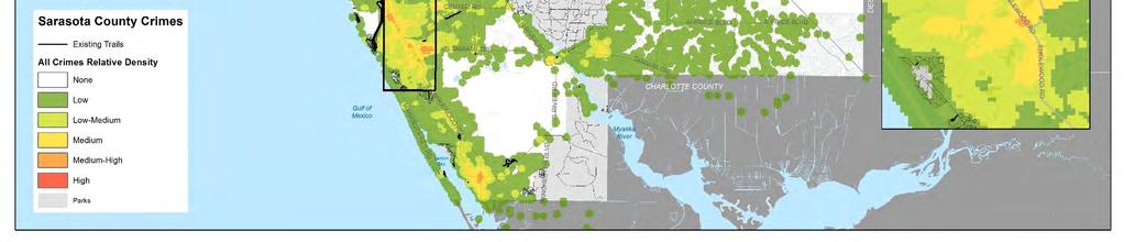
81 Sarasota County Trails Master Plan 78


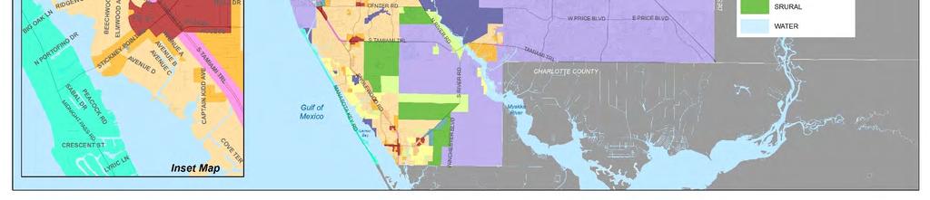
82 Sarasota County Trails Master Plan 79


83 Sarasota County Trails Master Plan 80

84 Sarasota County Trails Master Plan 81

85 Sarasota County Trails Master Plan 82

86 Sarasota County Trails Master Plan 83

87 Sarasota County Trails Master Plan 84

88 Sarasota County Trails Master Plan 85


89 Sarasota County Trails Master Plan 86


90 Sarasota County Trails Master Plan 87


91 Sarasota County Trails Master Plan 88
Blueways: Rivers, lakes, or streams with public access for recreation that includes fishing, nature observation, and opportunities for boating.
 Parks, Open Space and Trails PRINCE WILLIAM COUNTY 2008 COMPREHENSIVE PLAN TRAILS PLAN CONTENTS The components of the trails plan are: Intent Definitions Goals, Policies, and Action Strategies Trails Map
Chapter 6: POLICY AND PROCEDURE RECOMMENDATIONS
 Chapter 6 POLICY AND PROCEDURE RECOMMENDATIONS FOR SRRA Below are seven policy elements that should be considered for adoption by the Southwest Regional Recreation Authority of Virginia: 1. Develop strategies
Longmont to Boulder Regional Trail Jay Road Connection DRAFT FINAL REPORT
 Longmont to Boulder Regional Trail Jay Road Connection DRAFT FINAL REPORT December 2018 Project Summary Boulder County, Colorado, in partnership with the City of Boulder, is evaluating options for multi-use
FEASIBILITY CRITERIA
 This chapter describes the methodology and criteria used to evaluate the feasibility of developing trails throughout the study areas. Land availability, habitat sensitivity, roadway crossings and on-street
Committee. Presentation Outline
 CW-33-15 11/9/2015 Community and Corporate Services Committee November 10, 2015 1 Presentation Outline Background Vision and Objectives Study Process and Timeline Public and Stakeholder Engagement Organization
2. Goals and Policies. The following are the adopted Parks and Trails Goals for Stillwater Township:
 D. PARKS AND TRAILS 1. Introduction Stillwater Township s population is relatively low, with most residents living on rural residences on large lots. The need for active park space has been minimal in
$866,000. $1,400,000 Health Benefits $13,156,000 TOTAL ANNUAL DIRECT BENEFITS. $10,890,000 Economic Benefits
 SINGING RIVER TRAIL Trails Create Value + Generate Economic Activity Trails generate economic returns through improved health, safety, and environmental conditions, raise property values, and attract visitors.
AGENDA ITEM 5 D WAKULLA ENVIRONMENTAL INSTITUTE (WEI) TRAIL FEASIBILITY STUDY
 TRAIL FEASIBILITY STUDY") March 19, 2018 AGENDA ITEM 5 D WAKULLA ENVIRONMENTAL INSTITUTE (WEI) TRAIL FEASIBILITY STUDY TYPE OF ITEM: Action STATEMENT OF ISSUE The Wakulla Environmental Institute (WEI) Trail is one of several trails
March 19, 2018 AGENDA ITEM 5 D WAKULLA ENVIRONMENTAL INSTITUTE (WEI) TRAIL FEASIBILITY STUDY TYPE OF ITEM: Action STATEMENT OF ISSUE The Wakulla Environmental Institute (WEI) Trail is one of several trails
The Vision for the San Juan Islands Scenic Byway
 The Vision for the San Juan Islands Scenic Byway 2 Judd Cove, Orcas Island, Courtesy of Kurt Thorson (kurtthorson.com) and San Juan County Land Bank Vision for the San Juan Islands Scenic Byway The San
Welcome to the Cross County Trail Public Input Session!
 Welcome to the Cross County Trail Public Input Session! Please sign in on the table below! What are we doing here? Camden County has proposed a bicycle and pedestrian trail spanning across the entire county.
ANCLOTE COASTAL TRAIL ALTERNATIVES ANALYSIS STUDY
 ANCLOTE COASTAL TRAIL ALTERNATIVES ANALYSIS STUDY PASCO COUNTY MPO JULY 2015 PROJECT OVERVIEW... INTRODUCTION EXECUTIVE SUMMARY CONTEXT... TAMPA BAY AREA, PINELLAS, & PASCO COUNTY S MULTI-USE TRAIL PLANS
Chapter 6. Action Program. Heart of the Lakes Area Recreation Plan
 Heart of the Lakes Area Recreation Plan 1. Design and construct the following trails (please see the following map): a. the Speedway Trail 1) primary pathway the main trail 2) secondary pathway the proposed
Business Item No
 Metropolitan Parks and Open Space Commission Meeting date: February 6, 2018 For the Community Development Committee meeting of February 20, 2018 For the Metropolitan Council meeting of February 28, 2018
Gold Coast. Rapid Transit. Chapter twelve Social impact. Chapter content
 Gold Coast Rapid Transit Chapter twelve Social impact Chapter content Social impact assessment process...235 Existing community profile...237 Consultation...238 Social impacts and mitigation strategies...239
Coast to Coast Connector Summit
 Project Partners Welcome to the Coast to Coast Connector Summit Winter Garden, Florida City Hall October 1, 2014 1 Why are we here? Objectives 1. Inform key stakeholders on the current state of the C2C
SOUTH INTERCHANGE AREA
 Santaquin City General Plan 1 Location and Characteristics The South Interchange Area of Santaquin is located west of Interstate 15 and south of 500 South (Figure 1). It includes properties already annexed
CHAPTER ONE LITERATURE REVIEW
 CHAPTER ONE LITERATURE REVIEW LITERATURE REVIEW This chapter summarizes the most recently published community impact studies and articles that relate to multiuse trails. The review focuses on publications
Airport Planning Area
 PLANNING AREA POLICIES l AIRPORT Airport Planning Area LOCATION AND CONTEXT The Airport Planning Area ( Airport area ) is a key part of Boise s economy and transportation network; it features a multi-purpose
PREFACE. Service frequency; Hours of service; Service coverage; Passenger loading; Reliability, and Transit vs. auto travel time.
 PREFACE The Florida Department of Transportation (FDOT) has embarked upon a statewide evaluation of transit system performance. The outcome of this evaluation is a benchmark of transit performance that
Waukee Trailhead Public Art and Amenities Project
 Waukee - Trailhead Public Art and Amenities Project Sponsor Waukee Project Title Waukee Trailhead Public Art and Amenities Project Termini Description ( i.e. Park Avenue to 19th Street) NE Intersection
Georgetown-Lewes Rail/Trail Study. Rail/Trail Study: Cool Spring to Cape Henlopen State Park New Road Extension (House Resolution No.
 Georgetown-Lewes Rail/Trail Study Rail/Trail Study: Cool Spring to Cape Henlopen State Park New Road Extension (House Resolution No. 47) August 22, 2011 Presentation Outline Background Benefits Statewide
2016 Regional Transportation Alternatives Program (TAP) Grant Application
 Grant Application") 2016 Regional Transportation Alternatives Program (TAP) Grant Application PROJECT TITLE: Yelm-Tenino Trail Extension Feasibility Study TRPC use only GENERAL PROJECT INFORMATION Agency or Organization City
2016 Regional Transportation Alternatives Program (TAP) Grant Application PROJECT TITLE: Yelm-Tenino Trail Extension Feasibility Study TRPC use only GENERAL PROJECT INFORMATION Agency or Organization City
Washington Township MASTER PLAN. Addendum: Washington Township Master Plan
 Washington Township MASTER PLAN Addendum: Washington Township Master Plan CHAPTER XI RECREATION CORE DISTRICT Introduction The Recreation Core District generally encompasses the areas north of 30 Mile
BACKCOUNTRY TRAIL FLOOD REHABILITATION PROGRAM
 BACKCOUNTRY TRAIL FLOOD REHABILITATION PROGRAM Backcountry Trail Flood Rehabilitation A June 2013 Flood Recovery Program Summary In June 2013, parts of Southern Alberta were devastated from significant
This Executive Summary highlights the results of a multi-year planning process and includes recommendations of the New Jersey Trails Plan.
 Purpose and Scope The New Jersey Trails Plan presents a renewed vision, goals and strategic actions to help guide the efforts of all those who plan, build, operate and maintain New Jersey s trails. Building
TransAction Overview. Introduction. Vision. NVTA Jurisdictions
 Introduction Vision NVTA Jurisdictions In the 21 st century, Northern Virginia will develop and sustain a multimodal transportation system that enhances quality of life and supports economic growth. Investments
Silver Lake Park An Environmental Jewel for the Citizens of Prince William County
 Silver Lake Park An Environmental Jewel for the Citizens of Prince William County The Prince William Park Authority Mission Statement states: The Prince William County Park Authority will create quality
A CASE FOR COMPLETING THE JORDAN RIVER PARKWAY: A
 A CASE FOR COMPLETING THE JORDAN RIVER PARKWAY: A safe crossing at 9000 South and 850 West Proposed 9000 South Underpass Parkway Timeline Parkway, Trail, and Tourism Facts Blueprint Jordan River 1971 1973
EXECUTIVE SUMMARY PROGRAM DEVELOPMENT REPORT PURPOSE EXISTING SETTING EXPANDING PARKLAND
 EXECUTIVE SUMMARY PROGRAM DEVELOPMENT REPORT PURPOSE As the culmination of the first phase of the master planning process, this Program Development Report creates the framework to develop the Calero County
COASTAL CONSERVANCY. Staff Recommendation December 2, 2004 COYOTE HELLYER COUNTY PARK BAY AREA RIDGE TRAIL
 COASTAL CONSERVANCY Staff Recommendation December 2, 2004 COYOTE HELLYER COUNTY PARK BAY AREA RIDGE TRAIL File No. 04-057 Project Manager: Amy Hutzel RECOMMENDED ACTION: Authorization to disburse up to
Non-Motorized Transportation
 Non-Motorized Transportation Non-motorized facilities are important components to the transportation system. They provide an environmentally-friendly, low-cost mode of travel. Some of the facilities can
PEMBERTON VALLEY RECREATIONAL TRAILS MASTER PLAN UPDATE Community Open House. April 2018
 PEMBERTON VALLEY RECREATIONAL TRAILS MASTER PLAN UPDATE Community Open House April 2018 Introductions Introductions Matt Bakker, BHA Project Coordinator Other Team Members: Liz Scroggins, Grey Owl Consulting
IL 390 Station. Wood Dale Open House Summary 5/18/17
 Wood Dale Open House Summary 5/18/17 The first public open house for the Wood Dale Comprehensive Plan took place on May 18 th, 2017. The program was conducted as a fun community event and there were 216
DRAFT - APRIL 13, 2007 ROUTING STUDY FOR TRAIL CONNECTIONS BETWEEN CALAIS AND AYERS JUNCTION
 DRAFT - APRIL 13, 2007 ROUTING STUDY FOR TRAIL CONNECTIONS BETWEEN CALAIS AND AYERS JUNCTION Abstract The vision for the East Coast Greenway is an off-road urban trail system running from Calais, Maine
RE: Access Fund Comments on Yosemite National Park Wilderness Stewardship Plan, Preliminary Ideas and Concepts
 September 30, 2016 Superintendent Yosemite National Park Attn: Wilderness Stewardship Plan P.O. Box 577 Yosemite, CA 95389 RE: Access Fund Comments on Yosemite National Park Wilderness Stewardship Plan,
Regional Wayfinding Sign Strategy Thurston County Trails 2017
 Regional Wayfinding Sign Strategy Thurston County Trails 2017 Partners: Members and partnering organizations of the Thurston Thrives Community Design Action Team City of Lacey, City of Olympia, City of
Proposal to Redevelop Lower Kananaskis River-Barrier Lake. Bow Valley Provincial Park. Frequently Asked Questions
 Proposal to Redevelop Lower Kananaskis River-Barrier Lake Bow Valley Provincial Park Frequently Asked Questions What is being proposed? What are the details of the proposal? Where is the project area located?
!" # $ % & % ' ( '' ) ) ) ) )
 ) ) ) )") !" #$% &% ' ( ')) ))) #% * % ) +#% *- *,% ) Trails Attract Business, Residents and Tourists National Association of Homebuilders 0% 20% 40% 60% % of What People Desired Exercise Facilities Proximity to
!" #$% &% ' ( ')) ))) #% * % ) +#% *- *,% ) Trails Attract Business, Residents and Tourists National Association of Homebuilders 0% 20% 40% 60% % of What People Desired Exercise Facilities Proximity to
Section II. Planning & Public Process Planning for the Baker/Carver Regional Trail began in 2010 as a City of Minnetrista initiative.
 Section II Planning & Public Process Planning for the began in 2010 as a City of initiative. city staff began discussions with the Park District on the possibility of a north/south regional trail connection
Header i
 Header i 048285014.10 Header Sub Title Body Text here. Body text here. Body text here. Section 1... 1 Executive Summary... 1 Opportunities and Constraints... 3 Overall Opportunities and Constraints Map
URBAN DESIGN REPORT. Proposed Residential Development, Old Church Road, Caledon East
 Proposed Residential Development, Old Church Road, Caledon East TABLE CONTENTS: 1.0 DEVELOPMENT 1.1 Introduction-Analysis of Guiding Principles and Documents 1.2 Community Design and Architectural Design
Macleod Trail Corridor Study. Welcome. Macleod Trail Corridor Study Open House. Presentation of Proposed Design Concepts
 Macleod Trail Corridor Study Welcome Macleod Trail Corridor Study Open House Presentation of Proposed Design Concepts Study Purpose Develop a corridor plan for Macleod Trail that aligns with The City s:
Mohawk Hudson Bike Hike Trail Crossroad Connection Study
 Summary Report - April 21, 2003 Mohawk Hudson Bike Hike Trail Crossroad Connection Study Summary Report Introduction The Capital District Transportation Committee (CDTC), in partnership with Albany County,
PELICAN ISLAND COMMUNITY PARTNERSHIP SCHOOL. Bylaws
 PELICAN ISLAND COMMUNITY PARTNERSHIP SCHOOL Bylaws Article I. Name A. The name of this organization shall be Pelican Island Elementary, A Community Partnership School. B. The designated service area shall
At the time, the portion of the line through Eagle County remains wholly under the ownership of Union Pacific Railroad (UP).
.") Chapter 5 The Railroad Corridor as a Trail Corridor The intent of this chapter is to identify how the rail corridor, if available for lease or purchase in all or part, could be incorporated into the core
Chapter 5 The Railroad Corridor as a Trail Corridor The intent of this chapter is to identify how the rail corridor, if available for lease or purchase in all or part, could be incorporated into the core
University Region Non-Motorized Plan 2015
 Non-Motorized Transportation Non-motorized facilities are important components to the transportation system. They provide an environmentally-friendly, low-cost mode of travel. Some of the facilities can
Criteria Based System for MPRB Regional Park and Trail Capital Project Scheduling
 Criteria Based System for MPRB Regional Park and Trail Capital Project Scheduling July 19, 2017 Background Beginning with the 2017-2022 Capital Improvement Program (CIP), MPRB used equity-driven metrics
3.0 LEARNING FROM CHATHAM-KENT S CITIZENS
 3.0 LEARNING FROM CHATHAM-KENT S CITIZENS An important aspect in developing the Chatham-Kent Trails Master Plan was to obtain input from stakeholders and the general public. Throughout the course of the
ON THE RANCH NEWSLETTER OCTOBER 5, 2018
 ON THE RANCH NEWSLETTER OCTOBER 5, 2018 WWW.PALMERRANCH.NET News You Can Use 37 TH ANNUAL NATIONAL FALLEN FIREFIGHTERS DAY Flags on Palmer Ranch will be flown at half-staff from sunrise to sunset on Sunday,
MEETING MINUTES District 1 Trail Planning Meeting 1
 MEETING MINUTES District 1 Trail Planning Meeting 1 June 1, 2017 2:00 PM 3:30 PM City of Two Harbors 2:00 Introductions Attendees: Lisa Austin, MnDOT Bryan Anderson, MnDOT Jasna Hadzic-Stanek, MnDOT Justin
CHAPTER FIVE PROSPECTS FOR FUTURE ECONOMIC DEVELOPMENT
 CHAPTER FIVE PROSPECTS FOR FUTURE ECONOMIC DEVELOPMENT 5.1 GENERAL The recommended type and location of future land uses in Alpine should, in part, consider potential opportunities for future economic
Northaven Trail Phase 2 Initial Project Overview
 Northaven Trail Phase 2 Initial Project Overview Partnership Project to extend existing Northaven Trail Improve Bike/Ped Connectivity On Dallas Trail Network Plan City and County Funding Oncor Texas Trails
Colorado Springs & Pikes Peak Region Destination Master Plan
 Colorado Springs & Pikes Peak Region Destination Master Plan Overview June 19, 2018 DESTINATION MASTER PLAN What is Destination Master Planning? Focus on infrastructure, facilities, services, attractions
Business Item No XXX. Proposed Action That the Metropolitan Council approve the Coon Creek Regional Trail Master Plan.
 Business Item No. 2015-XXX Metropolitan Parks and Open Space Commission Meeting date: July 7, 2015 For the Community Development Committee meeting of July 20, 2015 For the Metropolitan Council meeting
Port Gamble Shoreline Area Conceptual Trail Proposal
 The North Kitsap Trails Association is pleased to be a partner to the Kitsap Forest and Bay Project and assist Kitsap County, Forterra, Olympic Property Group, Great Peninsula Conservancy and the Port
Rogue River Access and Management Plan Draft Alternatives
 Rogue River Access and Management Plan Draft Alternatives The Rogue River Access and Management Plan was initiated in December, 2011 and is being led by Jackson County Parks (JCP) and Oregon Department
11. Recreational Trails and Pathways Needs
 11. Recreational Trails and Pathways Needs Background Walking, biking, hiking, in-line skating, canoeing, and other trail- and pathway-related activities are important to Boiseans. This importance is demonstrated
Proposal to Redevelop Lower Kananaskis River-Barrier Lake. Bow Valley Provincial Park
 Frequently Asked Questions Proposal to Redevelop Lower Kananaskis River-Barrier Lake Bow Valley Provincial Park Frequently Asked Questions What has been decided? What are the details of the plan? What
LAKE APOPKA NORTH SHORE ECO TOURISM. Strategic Action Plan 4/10/2014
 LAKE APOPKA NORTH SHORE ECO ECO-TOURISM TOURISM 4/10/2014 Strategic Action Plan The purpose of this report is to identify strategic actions for implementing a comprehensive ecotourism plan for the North
2017 TBARTA Future Regional Priority Projects Adopted by TBARTA Board, December 9, 2016
 2017 TBARTA Future Regional Priority Projects Adopted by TBARTA Board, December 9, 2016 Project numbers do not signify ranking they are for mapping identification purposes only. 1. 15th Street East The
Draft for approval by TCC on 2/3, TAQC on 2/9 and ARC Board on 2/22. Regional Trail Plan. Mike Alexander, Director, Center for Livable Communities
 DATE: February 3, 2017 ISSUE SUMMARY: Regional Trail Plan FROM: Mike Alexander, Director, Center for Livable Communities IMPORTANCE: In May 2016, ARC adopted the active transportation component of the
FINAL TESTIMONY 1 COMMITTEE ON RESOURCES UNITED STATES HOUSE OF REPRESENTATIVES. July 13, 2005 CONCERNING. Motorized Recreational Use of Federal Lands
 FINAL TESTIMONY 1 STATEMENT OF DALE BOSWORTH CHIEF Of the FOREST SERVICE UNITED STATES DEPARTMENT OF AGRICULTURE Before the SUBCOMMITTEE ON FORESTS AND FOREST HEALTH And the SUBCOMMITTEE ON NATIONAL PARKS,
Parkland County Municipal Development Plan Amendment Acheson Industrial Area Structure Plan
 Parkland County Municipal Development Plan Amendment Acheson Industrial Area Structure Plan New Plan Acheson Industrial Area Structure Plan Amendment Parkland County Municipal Development Plan Board Reference
WINTER SHELTER IN EAST KING COUNTY
 WINTER SHELTER IN EAST KING COUNTY Vision Statement Every person in East King County has the opportunity to live in a safe, affordable, healthy home. Value Statement Homelessness is an experience that
State Park Visitor Survey
 State Park Visitor Survey Methods, Findings and Conclusions State s Department of Recreation, Park and Tourism Management surveyed state park visitor and trip characteristics, and collected evaluations
Northeast Quadrant Distinctive Features
 NORTHEAST QUADRANT Northeast Quadrant Distinctive Features LAND USE The Northeast Quadrant includes all the area within the planning area that is east of Interstate 5 and to the north of State Route 44.
Resort Municipality Initiative Annual Report 2015
 Resort Municipality Initiative Annual Report 2015 Submitted by: City of Rossland in association with Tourism Rossland Prepared by: Deanne Steven Acknowledgements The City of Rossland would like to thank
Crown Corporation BUSINESS PLANS FOR THE FISCAL YEAR Trade Centre Limited. Table of Contents. Business Plan
 Crown Corporation BUSINESS PLANS FOR THE FISCAL YEAR 2014 2015 Trade Centre Limited Business Plan 2014 2015 Table of Contents Message from the CEO and the Chair... Mission... Planning Context... Strategic
Pinellas County Environmental Lands
 Pinellas County Environmental Lands In addition to traditional parks and recreation facilities, Pinellas County owns and manages a system of environmental lands that provides specialized resource-based
Memo. Orange City Trail Plan Becky Mendez, AICP Jamie Krzeminski, PE, PTOE Matt Wiesenfeld, PE, AICP. Development of the Existing and Proposed Network
 Memo Date: Friday, December 22, 2017 Project: To: From: Subject: Trail Plan Becky Mendez, AICP Jamie Krzeminski, PE, PTOE Matt Wiesenfeld, PE, AICP Development of the Existing and Proposed Network HDR
13.1 REGIONAL TOURISM ISSUES AND SUMMARY OF FINDINGS
 13 REGIONAL TOURISM T he County of Mariposa s recreation needs and facilities fall within two categories: regional tourism and local recreation. This Element focuses on regional tourism issues related
A number of goals were identified during the initial work on this Big Lake Transportation Plan.
 C. Transportation General Background Information Big Lake s transportation system includes all the roads, paths and facilities that allow the movement of private vehicles, trains and planes, as well as
Preferred Recreation Recommendations Stemilt-Squilchuck Recreation Plan March 2018
 Preferred Recreation Recommendations Stemilt-Squilchuck Recreation Plan March 2018 Below are the recommended recreation ideas and strategies that package together the various recreation concepts compiled
Logo Department Name Agency Organization Organization Address Information 5700 North Sabino Canyon Road
 Logo Department Name Agency Organization Organization Address Information United States Forest Coronado National Forest 5700 North Sabino Canyon Road Department of Service Santa Catalina Ranger District
Lafourche Parish Government REQUEST FOR QUALIFICATIONS. Landscape Architectural Services
 Lafourche Parish Government REQUEST FOR QUALIFICATIONS Landscape Architectural Services Bayou Lafourche Parish Multi-Use Path Feasibility Study Phase 1 And Bayou Lafourche Parish Multi-Use Path Feasibility
PSP 75 Lancefield Road. Northern Jacksons Creek Crossing Supplementary Information
 PSP 75 Lancefield Road Northern Jacksons Creek Crossing Supplementary Information September 2017 The northern crossing of Jacksons Creek proposed within the Lancefield Road PSP is a key part of the ultimate
2014 STATEWIDE COMPREHENSIVE OUTDOOR RECREATION PLAN
 2014 STATEWIDE COMPREHENSIVE OUTDOOR RECREATION PLAN SUSTAINING COLORADO S OUTDOOR RECREATION FUTURE SECTION 1: INTRODUCTORY INFORMATION WHAT IS THE SCORP? The SCORP update is required every five years
City of Durango 5.8 FUNDING TRAILS DEVELOPMENT
 5.8 FUNDING TRAILS DEVELOPMENT The City has been successful in establishing dedicated local funding sources as well as applying for grants to develop the City s trail system, having received nearly $2.4
MONTEREY REGIONAL AIRPORT MASTER PLAN TOPICAL QUESTIONS FROM THE PLANNING ADVISORY COMMITTEE AND TOPICAL RESPONSES
 MONTEREY REGIONAL AIRPORT MASTER PLAN TOPICAL QUESTIONS FROM THE PLANNING ADVISORY COMMITTEE AND TOPICAL RESPONSES Recurring topics emerged in some of the comments and questions raised by members of the
Cross Florida Beach to Beach Adventure Bicycle Route
 Cross Florida Beach to Beach Adventure Bicycle Route 240 Miles from Juno Beach to Venice Beach This document can be viewed and downloaded from the Cross Florida Adventure Bicycle Route tab at www.bikeveniceflorida.com
Sacramento Placerville Transportation Corridor Alternatives Analysis
 Sacramento Placerville Transportation Corridor Alternatives Analysis EL DORADO COUNTY TRANSPORTATION COMMISSION 1 Sacramento Placerville Transportation Corridor 2 Goal of the Project To give public officials
Appendix 3. Greenway Design Standards. The Whitemarsh Township Greenway Plan
 Appendix 3 Greenway Design Standards This chapter discusses two design standards for the greenway types discussed above. First, trail design standards are presented together with trailhead facilities and
Flow Stand Up Paddle Board Parkway Plan Analysis
 Regional Parks Department Jeffrey R. Leatherman, Director County of Sacramento Divisions Administration Golf Leisure Services Maintenance Rangers Therapeutic Recreation Services Flow Stand Up Paddle Board
Jefferson County Non-Motorized Transportation and Recreational Trails Plan 2010
 Chapter 8: Goals and objectives Plan Update: The following update presents general principles, goals, and objectives related to non-motorized transportation facilities as a component of the overall transportation
Citrus Heights Creek Corridor Trail Project Trail Advisory Group Field Trip #2 September 11, :00 11:00 am Trellis Hall, Citrus Heights
 September 11, 2013 9:00 11:00 am Trellis Hall, Citrus Heights Project Overview The City of Citrus Heights is studying the feasibility of establishing a multi use trail system within the City s 26 miles
Continental Divide National Scenic Trail Legislative History and Planning Guidance
 Continental Divide National Scenic Trail Legislative History and Planning Guidance Legislation, Policy, and Direction Regarding National Scenic Trails The National Trails System Act, P.L. 90-543, was passed
APPENDIX OFFICIAL MAP ORDINANCE OF HAMILTONBAN TOWNSHIP OFFICIAL MAP NARRATIVE
 APPENDIX A OFFICIAL MAP ORDINANCE OF HAMILTONBAN TOWNSHIP OFFICIAL MAP NARRATIVE INTRODUCTION: The Official Map of Hamiltonban Township has been prepared to identify those lands and features that Hamiltonban
Economic Development and Tourism
 SECTION 4 SECTION 4 Economic Development and Tourism 4. Economic Development and Tourism Tourism plays a very important role in Niagara s economy, providing employment and generating business for support
ROAD AND TRAIL PROJECT APPROVAL
 ROAD AND TRAIL PROJECT APPROVAL www.marincountyparks.org Marin County Parks, 3501 Civic Center Dr, Suite 260, San Rafael, CA 94903 DATE: July 12, 2017 PRESERVE: Gary Giacomini Open Space Preserve PROJECT:
Draft Concept Alternatives Analysis for the Inaugural Airport Program September 2005
 Section 10 Preferred Inaugural Airport Concept 10.0 Introduction The Preferred Inaugural Airport Concept for SSA was developed by adding the preferred support/ancillary facilities selected in Section 9
Recreation Opportunity Spectrum for River Management v
 Recreation Opportunity Spectrum for Management v. 120803 Introduction The following Recreation Opportunity Spectrum (ROS) characterizations and matrices mirror the presentation in the ROS Primer and Field
Better Towpaths for Everyone. A national policy for sharing towpaths
 Better Towpaths for Everyone A national policy for sharing towpaths Contents Foreword 2 Introduction 3 Consultation 3 Principles of towpath use 4 Better infrastructure 5 Towpath Design Guide 5 Better signs
The Economic Contributions of Agritourism in New Jersey
 The Economic Contributions of Agritourism in New Jersey Bulletin E333 Cooperative Extension Brian J. Schilling, Extension Specialist in Agricultural Policy Kevin P. Sullivan, Institutional Research Analyst
SR 934 Project Development And Environment (PD&E) Study
 Study") SR 934 Project Development And Environment (PD&E) Study Project Advisory Group Meeting March 1, 2018 State Road 934/NE/NW 79th Street from west of I-95 (NW 13th CT) to N. Bayshore Drive PD&E STUDY SR 934/NE/NW
SR 934 Project Development And Environment (PD&E) Study Project Advisory Group Meeting March 1, 2018 State Road 934/NE/NW 79th Street from west of I-95 (NW 13th CT) to N. Bayshore Drive PD&E STUDY SR 934/NE/NW
4.0 Context for the Crossing Project
 4.0 Context for the Crossing Project This section provides background information about key features of the North Douglas Crossing project area, and opportunities and constraints. This information is important
County of Peterborough Active Transportation Master Plan
 The TMP developed a conceptual AT/cycling network for Peterborough County that identified both on-road and off-road (trail) AT facilities. This was a coarse network based on the existing trails and off-road
Other Principle Arterials Minor Arterial Major Collector Minor Collector Local
 CHAPTER 10 TRANSPORTATION Introduction The system of public roads in East Pikeland Township is decidedly rural in character. Since the 1984, the road network has remained much the same, with the addition
Dungeness Recreation Area County Park Master Plan
 Dungeness Recreation Area County Park Public Outreach Meeting October 10, 2007 Project Overview USFWS Site Dungeness Recreation Area County Park Meeting Objectives: Re-Introduce project; provide status
COUNTY COMPREHENSIVE PLAN
 50 : Policy Statement Lewis County has a unique and attractive rural character, which makes it a wonderful place to visit and explore. The region abounds with recreation opportunities that attract visitors
January 14, Orange County Transportation Authority Attn: M2 NCCP/HCP 550 South Main Street P.O. Box Orange, CA
 Equestrian Trails, Inc. Corral 357 P.O. Box 1026 Trabuco Canyon, CA 92678 http://saddlebackcanyonriders.com/ President: James Iacono... 714-612-1789 January 14, 2016 Orange County Transportation Authority