National Wetland Inventory and Assessment High Altitude Himalayan Lakes
|
|
|
- Brendan Kelley
- 5 years ago
- Views:
Transcription

1 National Wetland Inventory and Assessment High Altitude Himalayan Lakes Sponsored by Ministry of Environment and Forests, Govt. of India Space Applications Centre Indian Space Research Organisation Ahmedabad March

2 Map showing elevation ranges of India and surrounding area

3 INFORMATION NOTE SAC/ESPA/NWIA/IN/01/2013 High Altitude Himalayan Lakes Under the National Wetland Inventory and Assessment project Sponsored by Ministry of Environment and Forests, Govt. of India 3D perspective view of Tso Kar Lake, Jammu & Kashmir S. Panigrahy, J. G. Patel and T.V.R.Murthy

4 2


5 BACKGROUND : The Himalayan region is dotted with hundreds of from low elevation to the high elevations. Many of the of Himalaya are fresh water ones, with or without inflow and out flow. The Himalayan show varying chemistry in terms of solutes, bio-geochemistry, and mineralogy vis-à-vis eco-hydrology of the. These are primarily related to enormous altitude variation governing the climate, vegetation, lithology, tectonics and type and intensity of erosion/ weathering at source. The mountain, caused by glacial activity, are termed as tarns by geographers. Tarns are found mostly in the upper reaches of the Himalaya, above 5500 m. The high altitude are fed by snow-melt, precipitation and springs whereas of lower altitudes receive water from local rains, through streams, Nalas and springs. Many large of Lesser Himalaya are fault basin formed due to tectonic activity resulting in blocking of the streams/rivers during Holocene period. These have main source of water through precipitation and underground springs. Such are found in Kumaun, Himachal Pradesh and Jammu. The Higher Himalayan of Spiti valley, on the other hand, are fed by snow-melt, precipitation and spring water flow. The high altitude are mostly oligotrophic unlike the low altitude, which are in various stages of trophic state due to strong anthropogenic influence, the high altitude are still have a pristine environment. High altitude, apart from their ecological significance, play crucial role in biodiversity, wildlife habitat and socio-economic aspects. The high altitude in Ladakh are the only breeding grounds for migratory bird species like the Black-necked Crane and Bar-headed Goose in India. Local communities living in the region are dependent upon the for their livelihood regardless of whether they are settled or nomadic. Pasture lands near the wetlands are used for grazing livestock. In Ladakh about 90 percent of the economy of local nomadic communities, near the, depend on their livestock which graze on wetland pastures. 3

6 Some like Tso Moriri (Jammu and Kashmir) and Manimaheshwar (Himachal Pradesh) are regarded as sacred and are revered by thousands of pilgrims each year. The largest lake in the Himalayas is the Pangong Tso, which is spread across the border between India and Tibet. It is situated at an altitude of 4238 m. It is nearly 134 km long and width of 8 km. A notable high (but not the highest) lake is the Gurudongmar in North Sikkim at an altitude of 5148 m. Other major include the Tsongmo Lake, near the Indo-China border in Sikkim (India). Two high altitude wetlands in India have been designated as Ramsar sites. These include Tso Moriri in the state of Jammu and Kashmir and Chandertal in Himachal Pradesh. include the wetland boundary, the water spread in preand post-monsoon season, area under aquatic vegetation, and qualitative turbidity of water. A classification system based on IUCN/RAMSAR definition and amenable from remotely sensed data was used to categorise the wetlands. Total 19 types of wetlands were delineated using a hierarchical system. This classification includes inland and coastal wetlands at level-i followed by level-ii comprising natural and manmade wetlands within level-i, which were further categorised into 19 types of wetlands at level-iii. High Altitude Wetland (HAW) is one of the class mapped, which is first such attempt in the country. NATIONAL WETLAND INVENTORY AND ASSESSMENT : Mapping of wetlands at 1:50,000 scale using satellite remote sensing data and creating a geospatial data base was taken up by Space Applications Centre under the project National Wetland Inventory and Assessment (NWIA) sponsored by Ministry of Environment & Forests. IRS P6 LISS III digital data having four spectral bands: Green, Red, Near Infra Red, and Short Wave Infra Red with spatial resolution of 24 m was used. IRS LISS IV multispectral data having 5.8 m spatial resolution was used additionally for mapping of Sikkim state. Two-date data: one acquired during pre-monsoon and another during post-monsoon period was used to decipher the status of wetlands during wet and dry period. The outputs IRS LISS III FCC showing the distinct signature of high altitude during pre-monsoon season 4
 are also mapped as point features and assigned 1.0 ha nominal area.")

7 INVENTORY OF HIGH ALTITUDE LAKES : All lying above 3000 m elevation are designated as high altitude ones in this work. Mapping of the is done at 1:50,000 scale. Small (<2.25 ha area ) are also mapped as point features and assigned 1.0 ha nominal area. The Digital Elevation Model (DEM) derived from ASTER/SRTM data was used to generate elevation contours and classify the as per altitude range. Spatial database of these was prepared at state, district and topographic map sheet level using coding system, where each lake has a unique identification number. Lakes give unique signature on the satellite images, Depending upon the state of water whether liquid phase or frozen, the boundary of the are prominent and can be discerned with high accuracy. The pre- and postmonsoon images reflect the status of water, vegetation and state (solid/liquid). Number, Size and Altitudinal Distribution of Lakes The Indian Himalayas cover approximately 591,000 km 2 or 18 per cent of India's land surface and spread over six Himalayan States viz Jammu and Kashmir, Himachal Pradesh, Uttrakhand, Sikkim, Arunachal Pradesh and some parts of West Bengal. A total 4699 High Altitude have been mapped at 1: 50,000 scale. This includes 1996 small (<2.25 ha area). The total area of high altitude is ha. The categorised under various sizes, show that there are only 12 belonging to the very large size category having more than 500 ha area. However, they contribute to highest share of lake area (75.6%). Number wise, the smallest size (<2.25 ha) have the largest share (42.4%), followed by very small ones (<10 ha) with 42.3% share. Size-wise distribution of high altitude Class Range of 1 Very Large > 500 ha Large ha Medium ha Small ha Very Small < 10 ha < 2.25 ha < 2.25 ha Total High Altitude in various states (frozen, semi-frozen and liquid) as manifested on LISS-III imagery Distribution of as per size 5

.")
8 Altitude-wise, maximum numbers of are observed in the elevation range of m. There are 2666 (56.2% of total number) mapped in this elevation range with ha area (79.9% area). Very large are also observed in this elevation range. Only 734 are mapped in the very high altitude range of >5000 m elevation. and Kashmir has the highest share of. Numberwise, around 44.7% of (2104 number) are found in this state with 87.2% share of total area. Arunachal Pradesh with 1672 contributes 9.4% of area, indicating small size of the. Distribution of as per altitudinal range in Himalaya (high: m, higher: m and very high: >5000 m). Altitude-wise distribution of high altitude in Himalaya Category Altitude range (m) of 1. High Altitude Higher Altitude Very high Altitude > Total State-wise distribution Two states: Jammu and Kashmir and Arunachal Pradesh harbour very large number of high altitude. Jammu Distribution of high altitude in Himalayan states, India State-wise distribution of high altitude in Himalaya of Lake area % Lake State 1 Arunachal Pradesh Himachal Pradesh Jammu and Kashmir Sikkim Uttarakhand Total
 are in the range of <10 ha area, followed by of the size of")
 of Jammu & Kashmir Total 1143 are mapped at 1:50,000 scale and 961 small (<2.25ha) are mapped as point features, taking the total number of to 2104.")

9 Jammu and Kashmir : Category Altitude Range (m) of 1. High Altitude Higher Altitude Very high Altitude > Total Size wise distribution showed that, among the mapped as polygons, maximum number (844) are in the range of <10 ha area, followed by of the size of ha area (185). However, this state have all the 12 large (>500 ha area), found in the Indian Himalaya. IRS AWiFS FCC (November 2006) of Jammu & Kashmir Total 1143 are mapped at 1:50,000 scale and 961 small (<2.25ha) are mapped as point features, taking the total number of to Altitude wise distribution of showed that maximum number of (1245) is in the elevation range of m. This state also have highest number of situated in very high altitude range of >5000 m. Size-wise distribution of high altitude in Jammu & Kashmir of Class Range 1 Very Large > 500 ha Large ha Medium ha Small ha Very Small < 10 ha < 2.25 ha < 2.25 ha Total The Pangong Tso is at a height of 4238 m above sea level is the largest lake in Ladakh. It is a saline lake. Tso Moriri and Tso Kar are two important, saline in nature are also located in Ladakh. Tso Moairi has been designated as Ramsar Site. Some of the other important in the region are, the Neelang Lake in Budgam, Patlong, Thaled, Longzang, Pangor etc. Altitude-wise distribution of in Jammu & Kashmir 7
.")


.")
10 LISS III FCC showing the Tso Moriri lake a Ramsar site (wetland area: ha, altitude: 4522m). Below: photograph of the lake showing the pristine environment. The Pangong Tso in Ladakh, India, the largest high altitude lake as seen in LISS III FCC and a scenic photograph of the lake. China A India (The Pangong Tso spread across India and China as seen in IRS LISS III FCC. Lake area in India is ha, altitude: 4238). Tsokar lake as seen in LISS III during post-monsoon (note the salt encrustation- A) 8


11 Arunachal Pradesh : Arunachal Pradesh is the easternmost state of India with geographical area of 81,424 sq km Total 1672 high altitude were delineated. The total area under these is ha, accounting for about 7.6 per cent of total wetland area of the state. Maximum number of are of small size (below 10 ha). There are no of very large size (>500 ha) in this state. Altitudinal distribution pattern of these showed that highest concentration is in the range of m elevation range. Size-wise statistics of high altitude in Arunachal Pradesh. of Class Range 1 Very Large > 500 ha Large ha Medium ha Small ha Very Small < 10 ha < 2.25 ha < 2.25 ha Total Map showing distribution of in relation to elevation gradients in Arunachal Pradesh IRS LISS III FCC showing numerous high altitude in Arunachal Pradesh ( below: photograph of some of the in Tawang district: courtesy- Dr S Mehta). Distribution of high altitude in relation to elevation gradient in Arunachal Pradesh Category Altitude range (m) of 1. High Altitude Higher Altitude Very high Altitude > Total
 are mapped as point features.")
.")

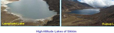
12 Sikkim : The total geographical area of the state is 7,096 km 2. High altitude accounting for per cent of the total wetland area. Results of 1:25,000 scale (using LISS IV) data is reported here. Total 677 are identified with 3226 ha area. Total mapped as polygons are 446 with 3109 ha area. In addition 231 small (<0.5 ha) are mapped as point features. Maximum number of are of very small size ( ha). Unlike Jammu and Kashmir, large size (>500 ha) are not observed in Sikkim. Satellite image showing the Gurudongmar Lake in frozen and liquid state (below: photograph of the lake in June). Size-wise statistics of high altitude in Sikkim of Class Range 1 Very Large > 500 ha Large ha Medium ha Small ha Very Small ha < 2.25 ha < 0.5 ha Total Gurudongmar Lake is a well known high altitude lake of the state. It is located in North Sikkim district at 5148 m elevation, and is considered a sacred lake. Chholhamu Lake, also in North Sikkim district, at 5014 m elevation is the important lake in Sikkim. The lake is located near Donkiala Pass. It is the source of the river Teesta (Tista). Tsomgu Lake is another important tourist destination in Sikkim. Altitudinal distribution shows that maximum numbers of are found above 4000 m elevation. Distributionwise, North Sikkim has the maximum number. There are only 27 in the elevation range of m. Distribution of high altitude in relation to elevation gradient in Sikkim Altitude of Category range (m) 1. High Altitude Higher Altitude Very High Altitude > Total

 are of very small size (<2.25 ha area). There are no above 100 ha area.")


13 Himachal Pradesh : Map showing distribution of in Sikkim in relation to elevation gradient ( > 3000 m). Himachal Pradesh is almost entirely mountainous with altitudes ranging from 460 to 6600 meters above sea level. Total 271 high altitude were delineated constituting 575 ha area that accounts for less than one per cent of total wetland area of the state. Maximum number of (230) are of very small size (<2.25 ha area). There are no above 100 ha area. Altitudinal distribution pattern of these wetlands showed that highest concentration is in the range of 4000 to 5000 m elevation range. Chandertal is the most famous high altitude lake in the state. This beautiful lake is situated at 4270 m, in Lahaul and Spiti district. This is the source of river Chandra. Manimahesh Lake at 4080 m lies in Budhil valley of Chamb district. Annual Manimahesh Yatra takes place after Janamasthami, in the month of August. Suraj Tal Located near Baralacha pass in Lahaul part of Lahaul and Spiti district at a height of 4890 m, is the source of Bhaga river. Dashair Lake at 4270 m lies near Rohtang pass which connects Kullu with Lahaul and Spiti. April 2006 January 2006 Tsomgu Lake as seen in IRS LISS III data and the photograph of the lake in June Size-wise statistics of high altitude in Himachal Pradesh Class Range of 1 Very Large > 500 ha Large ha Medium ha Small ha Very Small < 10 ha < 2.25 ha < 2.25 ha Total

 and mapped as point features. There are 28 distributed with range of <10 ha category and one lake in 10-25 ha.")

14 Altitude-wise statistics of the in Himachal Pradesh Category Altitude range(m) of 1. High Altitude Higher Altitude Very High Altitude > Total Uttarakhand : In all 118 high altitude were delineated constituting 231 ha area that accounts for less than one per cent of total wetland area of the state. Among the districts, Chamoli has the maximum number (60) with 112 ha area, followed by Pithoragarh district (25) with 76 ha area. Majority of the are of very small size (<2.25 ha) and mapped as point features. There are 28 distributed with range of <10 ha category and one lake in ha. Satellite image showing the Chandertal in semi frozen and melting state (below: photograph of the beautiful lake during July) Size-wise statistics of in Uttarakhand state of Class Range 1 Very Large > 500 ha Large ha Medium ha Small ha Very Small < 10 ha < 2.25 ha < 2.25 ha Total Altitudinal distribution pattern of these wetlands showed that about 68 wetlands exist in the elevation range of 4000 to 5000 m and 10 wetlands exist in the very high altitude (>5000 m). 12

 of 1.")

15 near famous Hindu shrine of Kedarnath. Other well known high in Chamoli district are Rupkund and Hemkund situated at 4450m and 4329 m altitude respectively. IRS LISS III FCC showing the distribution of high altitude in the Uttarkashi district. Altitude-wise statistics of in Uttarakhand state Category Altitude range (m) of 1. High Altitude Satellite image showing the Kedar tal lake (below: photograph of the pristine lake in June) 2. Higher Altitude Very High Altitude > Total Kedar Tal/Lake in Uttarkashi district at 4425 m elevation is a famous one. It is near Gangotri along Kedar Ganga, a tributary of Bhagirathi River. Shasra Lake is a popular destination for tourists, situated at 4572m. This splendid lake is in Uttarkashi district, after crossing the Kyarki Khar pass. Vasuki Tal/Lake in Chamoli district lies at 4135 m, 13
16 1 2 3 Summary of High altitude wetlands in India derived using LISS III data (2006-7) under NWIA project Description Jammu & Kashmir Himachal Pradesh Uttarakhand Sikkim Arunachal Pradesh West Bengal Total Wetland High Altitude Lakes % of total Wetland Total Altitudinal distribution of Himalayan in India High Altitude Higher Altitude Very High Altitude Total ( m) ( m) (>5000m) State of of of of 1 Arunachal Pradesh Himachal Pradesh Jammu and Kashmir Sikkim Uttarakhand State Total of Very Large (> 500 ha) Size-wise distribution of high altitude in India Large ( ha) of Medium ( ha) of Small (10-25 ha) of Very Small (<10 ha) of of <2.25 ha Total 1 Arunachal Pradesh Himachal Pradesh Jammu and Kashmir Sikkim Uttarakhand Total * Nominal assignment * of 14
17 Database structure of High altitude wetlands created under NWIA project (Example of the 12 large ) Wetland code** Location (Central Longitude, Latitude) 78 o 41' 1'' E, 33 o 43' 47'' N 79 o 52' 8' E, 35 o 12' 22'' N 78 o 19' 1'' E, 32 o 53' 44'' N 79 o 41' 27'' E, 34 o 40' 43'' N 78 o 00' 42'' E, 33 o 18' 48'' N 80 o 8' 53'' E, 35 o 3' 34'' N 79 o 21' 9'' E, 34 o 53' 17'' N 78 o 52' 26'' E, 33 o 31' 51'' N 78 o 55' 49'' E, 35 o 27' 45'' N 78 o 36' 5'' E, 32 o 55' 19'' N 80 o 3' 10'' E, 34 o 49' 52'' N 78 o 18' 8'' E, 33 o 6' 18'' N Perimeter (Km) Altitude (m) Name of the Lake State Pangong Tso Jammu and Kashmir Jammu and Kashmir Tso Morari Jammu and Kashmir Jammu and Kashmir Tso Kar Jammu and Kashmir Jammu and Kashmir Jammu and Kashmir Jammu and Kashmir Jammu and Kashmir Jammu and Kashmir Jammu and Kashmir Jammu and Kashmir Wetcode : Unique identification number 16 digit using State code(2) + District code(2) + Taluka code(2) + SOI topographic sheet code(6) + Wetland number(4) 15
 16")
18 3D perspective view of part of North District, Sikkim (IRS P6 LISS-IV image draped on DEM) 16
")
19 3D perspective view of part of West District, Sikkim (IRS P6 LISS-IV image draped on DEM) 17


20 Some of the Important High Altitude Lakes of India 18


21 Chandertal Lake (Himachal Pradesh) A Ramsar Site: The Chandertal with its deep blue icy water, surrounded by snow and acres of scree, constitute an important high altitude cold desert wetland of western Himalayas. The lake is in Lahul and Spiti district and situated at an altitude of 4270 metres. The clean water of the lake with small marshy patches around attracts many migratory birds. Important species noted are: Snow cock, Chukar, Black winged stilt, Brahmni duck, Golden eagle and Chugh, Hoopoe, Yellow Headed Wagtail, Jungle crow, Blue rock pigeon, Common rose finch, Black redstart, Short toed Eagle, Common Sandpiper, Teal, Magpie Robin etc. The important wild life species found in the region are Marmota Bobak, Snow leopard, Red fox, Snow wolf, Capra ibex, Blue sheep, and Lynx. The herbaceous growth in the catchment area is remarkable for its variety. The important species are Potentila, Ranunculus, Acquilegia, Primula, Aconitum, Aster, Asteraglus, Bistorta affinis,delphinium, Geranium, Oxyria, Potentilla, Polygonum, Ranunculus, Rosularia, Stellaria, and Thymus species. The common grasses frequently encountered are Poa and Agropyron. These grasses have rich nutritive value. Wetland map of 5 km buffer area: Chandertal Lake 19


22 Some interesting facts : A true lake should have some liquid water round the year. Thus, a high altitude lake which freezes solid all the way down to the bottom during the winter may be disqualified as a lake. A true "lake" must occupy at least 1.0 hectare. NASA declares: "At an altitude of 4727 m, Lake Mansarovar is one of the highest freshwater in the world. The very high altitude are generally volcanic ones lying on top of a volcano. However, they are very small in size. The lake at 6,390 m, on the east face of Ojos del Salado, the highest active volcano on the southeast side of the border between Chile and Argentina is the highest lake in the world. It is around 100 m in diameter, circular in shape, thus the surface area is hectare. Proper lake (if size is taken into account), "Ridonglabo Lake", around 3.0 hectares in size, lying at 5,801 meters may be called the highest lake. The lake is about 14 kilometers northeast of the summit of Mt. Everest. It's actually in a side valley on the northwest side of the main Karda Valley, where the Karda Glacier ends in Karda Lake. Source: Panch Pokhri is a group of three sacred in Nepal about 6 kilometers east of Ama Dablam (the mountain), is the highest named lake in the world The main lake is at 5414 m elevation; the other two are at 5430 m and 5494 m elevation respectively. Panch Pokhri (5494 m) is about 700 m long and 400 m wide. Lake Namtso in Tibet is the largest high altitude lake in the world. The altitude of Lake Namtso is 4700 m and the surface area is 1940 km 2. 20
 This is a complex of shallow ponds, marshes, and wet meadows in broad, sandy valley")


23 3D perspective view of Chushul Marshes and surrounding area, Ladakh Region IRS P6 LISS-III imagery, Post-monsoon(2006) This is a complex of shallow ponds, marshes, and wet meadows in broad, sandy valley to the east (10000 ha) and west (1000 ha) of Chusul. The ponds and marshes are created by the springs and streams flowing down into the valley from the Ladakh range to the southwest. The average depth of the ponds here is one or two meters. The aquatic vegetation found are: Hydrilla, Myriophyllum, and Potamogeton in the ponds, and Carex sp., other sedges, and grasses in the marshes. The surrounding arid steppe is dominated by Caragana sp. This is an important breeding area for several species of waterfowl, notably Podiceps cristatus, Tadorna ferruginea, Charadrius mongolus, Tringa tetanus, and Sterna hirundo. A number of species occur on the surrounding dry plains, including Tibetan partridge (Perdix hodgsoniae), Tibetan sandgrouse (Syrrhaptes tibetanus), and wild ass (Equus hemionus). : 675 ha Altitude: 4150m

24 For further details please contact: Director Space Applications Centre, ISRO Ambawadi Vistar (P.O.) Ahmedabad Adviser Ministry of Environment and Forests Paryavaran Bhavan CGO Complex New Delhi Cover: 3D Perspective view of Tso Moriri Lake, Jammu and Kashmir Back cover: Gurudongmar Lake, Sikkim
HIGH ALTITUDE LAKES OF INDIA
 Atlas SAC/EPSA/ABHG/NWIA/ATLAS/37/2012 NATIONAL WETLAND ATLAS : HIGH ALTITUDE LAKES OF INDIA Sponsored by Ministry of Environment and Forests, Government of India Space Applications Centre, ISRO, Government
Mountain Passes in Himalayas : India
 Mountain Passes in Himalayas : India Overall, the Himalayan mountain system is the world s highest, and is home to the world s highest peaks, the Eightthousanders. There are 14 Himalayan peaks with elevation
II. Objectives of the study:
 TERMS OF REFERENCE FOR ASCESSING VULNERABILITY OF SAGARMATHA NATIONAL PARK AND BUFFER ZONE AND FORMULATION OF THE COMMUNITY BASED ADAPTATION STRATEGIES I. Background: The Himalayan region having glacier
Adaptation in the Everest Region
 Adaptation in the Everest Region Bhawani S. Dongol Program Officer-Freshwater Program WWF- The Global Conservation Organization bhawani.dongol@wwfnepal.org 26 March 2010 Himalayan water towers The Himalayan
Climate Change and State of Himalayan Glaciers: Issues, Challenges and Facts
 Climate Change and State of Himalayan Glaciers: Issues, Challenges and Facts D.P. Dobhal dpdobhal@wihg.res.in Wadia Institute of Himalayan Geology Dehra Dun Major Issues Are the Himalayan glaciers receding
The Role of Glaciers in the Hydrologic Regime of the Nepal Himalaya. Donald Alford Richard Armstrong NSIDC Adina Racoviteanu NSIDC
 The Role of Glaciers in the Hydrologic Regime of the Nepal Himalaya Donald Alford Richard Armstrong NSIDC Adina Racoviteanu NSIDC Outline of the talk Study area and data bases Area altitude distributed
 Map 1.2 Distribution of various land uses in Chandigarh N W E S 0 0.5 1 NRIS National (Natural Resources Information System) Dept. of Space Sponsored Project Executed By: Punjab Remote Sensing Centre Ludhiana
Planning a National Aquatic Area Network (NAAN) for Conservation & Management of Rare, Threatened & Endangered Wetland Biodiversity
 for Conservation & Management of Rare, Threatened & Endangered Wetland Biodiversity") Planning a National Aquatic Area Network (NAAN) for Conservation & Management of Rare, Threatened & Endangered Wetland Biodiversity B.C. Choudhury bcc@wii.gov.in Keynote Presentation on Biodiversity &
Planning a National Aquatic Area Network (NAAN) for Conservation & Management of Rare, Threatened & Endangered Wetland Biodiversity B.C. Choudhury bcc@wii.gov.in Keynote Presentation on Biodiversity &
OUR COUNTRY INDIA L OCATIONAL SETTING
 7 India is a country of vast geographical expanse. In the north, it is bound by the lofty Himalayas. The Arabian Sea in the west, the Bay of Bengal in the east and the Indian Ocean in the south, wash the
Development of Ski Resorts in the Indian Himalayas
 Development of Ski Resorts in the Indian Himalayas AMITABH SHARMA SKI HIMALAYAS # 1 Pocket 52, C.R Park New Delhi 110019 +91-9816055555 Email : amitabhsharma_manali@rediffmail.com The Himalayas are a vast
India - State-wise Wastelands Distribution (Percentage to total geographical area)
") WASTELAND MAP 25-6 INDIA Figure. 1 Gullied/ Ravine land-medium ravine Gullied/Ravine land-deep/ very deep ravine Scrubland - Land with dense scrub Scrubland - Land with open scrub Waterlogged and marshy
WASTELAND MAP 25-6 INDIA Figure. 1 Gullied/ Ravine land-medium ravine Gullied/Ravine land-deep/ very deep ravine Scrubland - Land with dense scrub Scrubland - Land with open scrub Waterlogged and marshy
National Biodiversity Strategy and Action Plan, India
 Final Technical Report of the UNDP-GEF Sponsored Project National Biodiversity Strategy and Action Plan, India Volume 2 Executing Agency Ministry of Environment and Forests, Government of India Technical
Robson Valley Avalanche Tract Mapping Project
 Robson Valley Avalanche Tract Mapping Project Prepared for: Chris Ritchie Ministry of Water Land and Air Protection 325 1011 4th Avenue Prince George, BC. V2L3H9 and Dale Seip Ministry of Forests 1011
The Himalayan Future Transition, Equity and Ecological Stability. Jayanta Bandyopadhyay
 The Himalayan Future Transition, Equity and Ecological Stability Jayanta Bandyopadhyay Himalaya the Mountain of Diversity The Himalaya has been mentioned in many writings, both ancient and modern, scientific
Spatio-Temporal Dynamics of Large Mammals and Birds in Eco-Tourism Zone of Nanda Devi National Park
 ISSN (Print): 2454 7468 ISSN (Online): 2454-7476 www.eresearchco/jbcc/ Spatio-Temporal Dynamics of Large Mammals and Birds in Eco-Tourism Zone of Nanda Devi National Park Hem Chander* Department of Biosciences,
PHYSIOGRAPHIC DIVISION OF INDIA
 PHYSIOGRAPHIC DIVISION OF INDIA INTRODUCTION India is vast country there have great diversity in it s physical features. Physical Division Of India are divided into following five Division. 1. The Northern
The Potentially Dangerous Glacial Lakes
 Chapter 11 The Potentially Dangerous Glacial Lakes On the basis of actively retreating glaciers and other criteria, the potentially dangerous glacial lakes were identified using the spatial and attribute
Quick Revision Geography (India & World) [Series-2]
![Quick Revision Geography (India & World) [Series-2]](/thumbs/87/96516026.jpg "Quick Revision Geography (India & World) [Series-2]") Quick Revision Geography (India & World) [Series-2] Revision Notes For 2015 Economy, Environment, Geography, History, Polity, CA Compilation By TeamWork Important Images: Link (by Kaushal) NCERT Compilation:
Quick Revision Geography (India & World) [Series-2] Revision Notes For 2015 Economy, Environment, Geography, History, Polity, CA Compilation By TeamWork Important Images: Link (by Kaushal) NCERT Compilation:
Issues and Concerns. The industry contributed 4.9% to India s Gross Domestic Product (GDP) and has emerged as major source of employment.
 and has emerged as major source of employment.") Ecotourism Issues and Concerns Tourism is the world s fastest growing industry and in recent years, has come to play an increasingly dominant role in the economies of developing countries. The industry
Ecotourism Issues and Concerns Tourism is the world s fastest growing industry and in recent years, has come to play an increasingly dominant role in the economies of developing countries. The industry
Observation of cryosphere
 Observation of cryosphere By Sagar Ratna Bajracharya (email: sagar.bajracharya@icimod.org) Samjwal Ratna Bajracharya Arun Bhakta Shrestha International Centre for Integrated Mountain Development Kathmandu,
Croatia completes inventory of wetlands
 Croatia completes inventory of wetlands 16 October 2006 Croatia CRO-WET - Croatian Wetland Inventory SGF project completed The Croatian State Institute for Nature Protection (SINP) carried out a comprehensive
Hindu Kush Karakorum Pamir Landscape Initiative (HKPL)
") Hindu Kush Karakorum Pamir Landscape Initiative (HKPL) HKPL Team International Centre for Integrated Mountain Development Kathmandu, Nepal Dushanbe, 3 October 2017 The Inter-Governmental Institution A
Hindu Kush Karakorum Pamir Landscape Initiative (HKPL) HKPL Team International Centre for Integrated Mountain Development Kathmandu, Nepal Dushanbe, 3 October 2017 The Inter-Governmental Institution A
Retreating Glaciers of the Himalayas: A Case Study of Gangotri Glacier Using Satellite Images
 Retreating Glaciers of the Himalayas: A Case Study of Gangotri Glacier Using 1990-2009 Satellite Images Jennifer Ding Texas Academy of Mathematics and Science (TAMS) Mentor: Dr. Pinliang Dong Department
Islamic Republic of Pakistan Collaborative Management of Protected Areas First Asia Parks Congress, Sendai, Japan, November, 2012
 Islamic Republic of Pakistan Collaborative Management of Protected Areas First Asia Parks Congress, Sendai, Japan, 13-17 November, 2012 By: Muhammad Samar Hussain Khan Assistant Secretary (Wildlife) Forestry
12 Reasons Why You Must Visit Nepal This Year
 12 Reasons Why You Must Visit Nepal This Year 15 Jan,2016 Travel & Adventure Nepal, a wonderland in the lap of Himalaya. A small landlocked country in between the two giant countries of Asia: India and
Two Peaks in the Headwaters of Karcha Nala JAC Tokai to the Indian Himalayas
 KAZUO HOSHI Two Peaks in the Headwaters of Karcha Nala JAC Tokai to the Indian Himalayas The Tokai Section of the Japanese Alpine Club (hereinafter described as JAC Tokai) conducted 11 expeditions to the
Chapter 7 Geography and the Early Settlement of Egypt, Kush, and Canaan
 Chapter 7 Geography and the Early Settlement of Egypt, Kush, and Canaan How did geography affect early settlement in Egypt, Kush, and Canaan? Section 7.1 - Introduction RF/NASA//Corbis This satellite photograph
 +91-8048756753 Explore Himalayas http://www.ladakhvisit.com/ Since 1993 we are engaged in providing tour & travel services as Ladakh Tour Packages, Mountain Biking Tour, Markha Valley Trek, Markha Valley
Chapter 20. The Physical Geography of Africa South of the Sahara
 Chapter 20 The Physical Geography of Africa South of the Sahara Chapter Objectives Identify the major landforms, water systems, and natural resources of Africa south of the Sahara. Describe the relationship
Boatswain bay biodiversity reserve
 Boatswain bay biodiversity reserve March 2003 1 1. Plan and description 1.1. Geographic location, boundaries and dimensions The plan of the proposed Boatswain bay biodiversity reserve and its location
Chapter 7. Geography and the Early Settlement of Egypt, Kush, and Canaan
 Chapter 7 Geography and the Early Settlement of Egypt, Kush, and Canaan Chapter 7 Geography and the Early Settlement of Egypt, Kush, and Canaan How did geography affect early in Egypt Kush, and Canaan?
Geoscape Toronto The Oak Ridges Moraine Activity 2 - Page 1 of 10 Information Bulletin
 About 13,000 years ago as the Laurentide Ice Sheet melted, glacial meltwater accumulated between the ice sheet and the Niagara Escarpment. This formed a lake basin into which gravel and sand were deposited.
Friday, November 10, 2017
 Friday, November 10, 2017 Andes and Midlatitude Countries Objective: Summarize the main physical features and regions of the Southern Cone. Identify and locate the urban centers and understand the pattern
Snow/Ice melt and Glacial Lake Outburst Flood in Himalayan region
 Snow/Ice melt and Glacial Lake Outburst Flood in Himalayan region Dr. SANJAY K JAIN NATIONAL INSTITUTE OF HYDROLOGY ROORKEE Modelling and management flood risk in mountain areas 17-19 Feb., 2015 at Sacramento,
Terrestrial Protected Area Nomination: Central Mangrove Wetland South-West, Grand Cayman
 Terrestrial Protected Area Nomination: Central Mangrove Wetland South-West, Grand Cayman The attached nomination, proposing that a parcel of land in the Central Mangrove Wetland be made a Protected Area
EUROPEAN COMMISSION DG XI.D.2. COUNCIL DIRECTIVE 79/409/EEC on the conservation of wild birds. and
 EUROPEAN COMMISSION DG XI.D.2 COUNCIL DIRECTIVE 79/409/EEC on the conservation of wild birds and COUNCIL DIRECTIVE 92/43/EEC on the conservation of natural habitats and of wild fauna and flora STANDARD
The 2nd Glacier Inventory of China
 The 2nd Glacier Inventory of China LIU Shiyin Guo Wanqin, Xu Junli, Shangguan Donghui, Wei Junfeng, Wu Lizong, Yu Pengchun, Li Jing, Liu Qiao State Key Laboratory of Cryospheric Sciences, Cold and Arid
GEOSPATIAL ANALYSIS OF GLACIAL HAZARDS PRONE AREAS OF SHIGAR AND SHAYOK BASINS OF PAKISTAN. By Syed Naseem Abbas Gilany
 GEOSPATIAL ANALYSIS OF GLACIAL HAZARDS PRONE AREAS OF SHIGAR AND SHAYOK BASINS OF PAKISTAN By Syed Naseem Abbas Gilany PRESENTATION OUTLINE Introduction Problem Statement / Rationale Objectives Material
Himalayan Glaciers Climate Change, Water Resources, and Water Security. Henry Vaux, Committee Chair December 10, 2012
 Himalayan Glaciers Climate Change, Water Resources, and Water Security Henry Vaux, Committee Chair December 10, 2012 Study Context Glacial meltwater is commonly thought h to significantly ifi contribute
Present health and dynamics of glaciers in the Himalayas and Arctic
 Present health and dynamics of glaciers in the Himalayas and Arctic AL. Ramanathan and Glacilogy Team School of Environmental Sciences, Jawaharlal Nehru University AL. Ramanthan, Parmanand Sharma, Arindan
Chapter 17. North Africa, Southwest Asia and Central Asia
 Chapter 17 North Africa, Southwest Asia and Central Asia Chapter Objectives Describe the major landforms and natural resources of North Africa, Southwest Asia, and Central Asia. Discuss the climate and
Creation of a Community-managed Biodiversity Park in the Saloum Delta of Senegal. Voré Gana Seck Director GREEN Senegal for People, Land, Ocean
 Creation of a Community-managed Biodiversity Park in the Saloum Delta of Senegal Voré Gana Seck Director GREEN Senegal for People, Land, Ocean Rationale for the Creation of the Biodiversity Park F In line
Alpine Glacial Features along the Chimney Pond Trail, Baxter State Park, Maine
 Maine Geologic Facts and Localities September, 2009 Alpine Glacial Features along the Chimney Pond Trail, Baxter State Park, Maine 45 54 57.98 N, 68 54 41.48 W Text by Robert A. Johnston, Department of
PARANG LA 5490M PARANG LA T REK July 26-Aug 11, 2019
 PARANG LA PARANG LA TREK July 26-Aug 11, 2019 PARANG LA: INTRODUCTION The Parang La trail follows the traditional trade route between the people of Spiti, Changthang and Tibet. It begins after the high-altitude
Terms to Know. artesian well coral atoll krill lagoon
 Chapter Objectives Describe the diverse landforms and natural resources of Australia, Oceania, and Antarctica. Discuss the wide range of climates and vegetation throughout the region. The Land Section
South, Southeast, and East Asia Physical Geography
 South, Southeast, and East Asia Physical Geography Mountains A. B. C. Mountains are important in Asia because they influence: Population patterns Movement of people and goods Climate Himalaya Mountains
Monitoring of Mountain Glacial Variations in Northern Pakistan, from 1992 to 2008 using Landsat and ALOS Data. R. Jilani, M.Haq, A.
 Monitoring of Mountain Glacial Variations in Northern Pakistan, from 1992 to 2008 using Landsat and ALOS Data R. Jilani, M.Haq, A. Naseer Pakistan Space & Upper Atmosphere Research Commission (SUPARCO)
Warming planet, melting glaciers
 Warming planet, melting glaciers Arun B Shrestha abshrestha@icimod.org International Centre for Integrated Mountain Development Kathmandu, Nepal Asia-Pacific Youth forum on Climate Actions and Mountain
Long term mass and energy balance monitoring of Nepalese glaciers (GLACIOCLIM project): Mera and Changri Nup glaciers
: Mera and Changri Nup glaciers") Long term mass and energy balance monitoring of Nepalese glaciers (GLACIOCLIM project): Mera and Changri Nup glaciers ICIMOD IRD collaboration Cryosphere team Who? o o o o The cryosphere team of ICIMOD,
Long term mass and energy balance monitoring of Nepalese glaciers (GLACIOCLIM project): Mera and Changri Nup glaciers ICIMOD IRD collaboration Cryosphere team Who? o o o o The cryosphere team of ICIMOD,
Glaciers as Source of Water: The Himalaya
 Sustainable Humanity, Sustainable Nature: Our Responsibility Pontifical Academy of Sciences, Extra Series 41, Vatican City 2014 Pontifical Academy of Social Sciences, Acta 19, Vatican City 2014 www.pas.va/content/dam/accademia/pdf/es41/es41-kulkarni.pdf
Dr. Lkhagvasuren Badamjav Leading Scientist, Institute of Biology Mongolian Academy of Sciences
 Transboundary landscape cooperation in the Altay-Sayan region: experiences and lessons learnt Dr. Lkhagvasuren Badamjav Leading Scientist, Institute of Biology Mongolian Academy of Sciences Stakeholder
REVIEWS. Monitoring Himalayan cryosphere using remote sensing techniques. Anil V. Kulkarni
 REVIEWS Moniring Himalayan cryosphere using remote sensing techniques Abstract In the Himalayas, large area is covered by glaciers, seasonal snow and changes in its extent can influence availability of
سبل تفعيل تنفيذ ا تفاقية الا راضى الرطبة فى المنطقة العربية
 CONVENTION ON WETLANDS "RAMSAR" AND THE ARAB REGION سبل تفعيل تنفيذ ا تفاقية الا راضى الرطبة فى المنطقة العربية "رامسار" National Institute of Oceanography and Fisheries WETLANDS SERVICES AND PRODUCTS
GEOGRAPHY AND HISTORY
 GEOGRAPHY AND HISTORY YEAR 1, PART 1 www.vicensvives.es Contents 01 Our planet Earth 02 The representation of the Earth: maps 03 The Earth s relief 04 Rivers and seas 05 Weather and climate 06 Climates
25 Best Trekking Location Of India One Should Not Miss
 25 Best Trekking Location Of India One Should Not Miss From the snow capped mountain ranges of Himalayas to rough glaciers to frozen rivers to delightfully colorful valleys of flowers. Indian landscape
Reconciling Conservation and Investment in the Gambella Omo Landscape, Ethiopia
 Reconciling Conservation and Investment in the Gambella Omo Landscape, Ethiopia Cherie Enawgaw Beyene Ethiopian Wildlife Conservation Authority March 2013 Background Ethiopia is a vast country with a land
What Is An Ecoregion?
 Ecoregions of Texas What Is An Ecoregion? Ecoregion a major ecosystem with distinctive geography, characteristic plants and animals, and ecosystems that receives uniform solar radiation and moisture Sometimes
Geographical Analysis of Strength and Weaknesses of Himachal Tourism
 International Journal of Humanities and Social Science Invention ISSN (Online): 2319 7722, ISSN (Print): 2319 7714 Volume 2 Issue 2 ǁ February. 2013ǁ PP.18-23 Geographical Analysis of Strength and Weaknesses
Conservation of Snow Leopards in the Kargil Himalayas, Ladakh, India
 National Geographic Stock / Steve Winter / WWF Conservation of Snow Leopards in the Kargil Himalayas, Ladakh, India Aishwarya Maheshwari Species and Landscapes WWF-India amaheshwari@wwfindia.org 19 April
Shrubs and alpine meadows represent the only vegetation cover.
 Saldur river General description The study area is the upper Saldur basin (Eastern Italian Alps), whose elevations range from 2150 m a.s.l. (location of the main monitoring site, LSG) and 3738 m a.s.l.
Hudson Bay Lowlands Proposed Protected Areas
 Hudson Bay Lowlands Proposed Protected Areas Hudson Bay Lowlands Proposed Protected Areas The Protected Areas Initiative has identified portions of the Hudson Bay Lowlands region that have significant
Cryosphere Monitoring Programme in the Hindu Kush Himalayas and Cryosphere Knowledge Hub
 Cryosphere Monitoring Programme in the Hindu Kush Himalayas and Cryosphere Knowledge Hub Pradeep Mool Programme Coordinator Cryosphere Initiative ICIMOD The First Asian CryoNet Workshop International Centre
UNIT 5 AFRICA PHYSICAL GEOGRAPHY SG 1 - PART II
 UNIT 5 AFRICA PHYSICAL GEOGRAPHY SG 1 - PART II III. CLIMATE & VEGETATION A. The four main climate zones are tropical wet, tropical wet/dry (split into monsoon & savanna), semiarid, and arid. Other climate
Case Study: Conserving Ecological Processes in the Eastern Himalayas
 Standard 7: Select terrestrial, freshwater and marine conservation biodiversity elements (a.k.a conservation targets) across multiple biological scales to comprehensively represent the biodiversity of
SLV POWER PRIVATE LIMITED ANIYUR MINI HYDEL SCHEME (3 X 8 MW = 24 MW) CATCHMENT AREA TREATMENT PLAN
 CATCHMENT AREA TREATMENT PLAN") SLV POWER PRIVATE LIMITED ANIYUR MINI HYDEL SCHEME (3 X 8 MW = 24 MW) CATCHMENT AREA TREATMENT PLAN 1. INTRODUCTION : M/s SLV Power Pvt. Ltd. Is setting up a Mini Hydel Scheme of 24 MW capacity across
SLV POWER PRIVATE LIMITED ANIYUR MINI HYDEL SCHEME (3 X 8 MW = 24 MW) CATCHMENT AREA TREATMENT PLAN 1. INTRODUCTION : M/s SLV Power Pvt. Ltd. Is setting up a Mini Hydel Scheme of 24 MW capacity across
DOWNLOAD OR READ : WILD ANIMALS OF LADAKH AN ECOLOGICAL STUDY OF THE WILDLIFE OF HIGH ALTITUDE ANIMALS OF LADAKH JAMMU PDF EBOOK EPUB MOBI
 DOWNLOAD OR READ : WILD ANIMALS OF LADAKH AN ECOLOGICAL STUDY OF THE WILDLIFE OF HIGH ALTITUDE ANIMALS OF LADAKH JAMMU PDF EBOOK EPUB MOBI Page 1 Page 2 ladakh jammu wild animals of ladakh pdf ladakh jammu
The Impact of Human Activities on Plant diversity in Nanda Devi Biosphere Reserve, West Himalaya, India
 The Impact of Human Activities on Plant diversity in Nanda Devi Biosphere Reserve, West Himalaya, India 1. INTRODUCTION Biosphere Reserves are the areas having rich ecosystem which are nominated by National
ROAD TRIP! DRIVE AND EXPLORE KINNAUR AND SPITI With Banjara Camps & Retreats and Rishad Saam Mehta 26 th June to 7 th July 2010
 ROAD TRIP! DRIVE AND EXPLORE KINNAUR AND SPITI With Banjara Camps & Retreats and Rishad Saam Mehta 26 th June to 7 th July 2010 Enjoy an adventurous yet luxurious driving holiday led by Rishad Saam Mehta
Region 1 Piney Woods
 Region 1 Piney Woods Piney Woods 1. This ecoregion is found in East Texas. 2. Climate: average annual rainfall of 36 to 50 inches is fairly uniformly distributed throughout the year, and humidity and temperatures
Maya s Creek Crossing Hwy 17 N acres $185,000 Fort Davis, Texas
 Maya s Creek Crossing Hwy 17 N 14.98 acres $185,000 Fort Davis, Texas James King, Agent Office 432-426-2024 Cell 432-386-2821 James@KingLandWater.com King Land & Water LLC P.O. Box 109, 600 State Street,
12 NIGHT/13 DAY FAMILY SAFARI NORTHERN TANZANIA
 12 NIGHT/13 DAY FAMILY SAFARI NORTHERN TANZANIA Day One - Lake Manyara On arrival into Kilimanjaro you are met and transferred directly to Lake Manyara National Park. Located 125 km west of Arusha town,
The dynamic response of Kolohai Glacier to climate change
 Article The dynamic response of Kolohai Glacier to climate change Asifa Rashid 1, M. R. G. Sayyed 2, Fayaz. A. Bhat 3 1 Department of Geology, Savitribai Phule Pune University, Pune 411007, India 2 Department
2.1 What is the climate like?
 José Medeiros This fact sheet allows you to see how varied the countryside is across Brazil. 2.1 What is the climate like? Most of Brazil is in the Southern Hemisphere, where the seasons are the opposite
Glaciers. Reading Practice
 Reading Practice A Glaciers Besides the earth s oceans, glacier ice is the largest source of water on earth. A glacier is a massive stream or sheet of ice that moves underneath itself under the influence
Climate Change Impacts on Glacial Lakes and Glacierized Basins in Nepal and Implications for Water Resources
 Climate Change Impacts on Glacial Lakes and Glacierized Basins in Nepal and Implications for Water Resources Suresh R. Chalise 1, Madan Lall Shrestha 2, Om Ratna Bajracharya 2 & Arun Bhakta Shrestha 2
TREK LADAKH - THE HIMALAYAN KINGDOMS
 TREK LADAKH - THE HIMALAYAN KINGDOMS 1 ITINERARY OUTLINE FOR BESPOKE TRIPS The Markha Valley Trek is certainly one of the most varied and beautiful treks in the world. It ventures high into the Himalayas
"Arror Rock" [near Rohri in Sindh] The shape of rock was caused by unknown natural forces. There is also a Shrine on the top.
![Arror Rock [near Rohri in Sindh] The shape of rock was caused by unknown natural forces. There is also a Shrine on the top.](/thumbs/73/68324813.jpg "Arror Rock [near Rohri in Sindh] The shape of rock was caused by unknown natural forces. There is also a Shrine on the top.") This is Pakistan "Astola Island" [near Pasni Baluchistan 40 km from shore]. Astola is Pakistan's largest offshore island and the only significant offshore island in the northern Arabian Sea. "Arror Rock"
This is Pakistan "Astola Island" [near Pasni Baluchistan 40 km from shore]. Astola is Pakistan's largest offshore island and the only significant offshore island in the northern Arabian Sea. "Arror Rock"
The SHARE contribution to the knowledge of the HKKH glaciers, the largest ice masses of our planet outside the polar regions
 The SHARE contribution to the knowledge of the HKKH glaciers, the largest ice masses of our planet outside the polar regions Claudio Smiraglia 1 with the collaboration of Guglielmina Diolaiuti 1 Christoph
PRIORITY HABITAT SURVEY 2017 SWALEDALE. Summary. July 2018
 PRIORITY HABITAT SURVEY 2017 SWALEDALE Summary July 2018 Conservation & Monitoring Report No: Lead Author(s): Tony Serjeant & Sue Thurley Incorporating comments from: Gary Smith & Gordon Haycock (16/07/18)
Ecological impacts in mountain protected areas
 Ecological impacts in mountain protected areas International Programme on Research and Training on Sustainable Management of Mountain Areas (IPROMO) July 2010 International Centre for Ecotourism Research,
Snow and Glacier Studies
 Final Technical Report Snow and Glacier Studies SPACE APPLICATIONS CENTRE, ISRO AHMEDABAD 380 015 MAY 2010 Snow and Glacier Studies (A joint Project of Ministry of Environment and Forests and Department
A GIS Analysis of Probable High Recreation Use Areas in Three Sisters Wilderness Deschutes and Willamette National Forests
 Lindsey Kiesz Geo 565 Term Project 3/15/2010 A GIS Analysis of Probable High Recreation Use Areas in Three Sisters Wilderness Deschutes and Willamette National Forests Introduction The Three Sisters Wilderness
ICPAC. IGAD Climate Prediction and Applications Centre Monthly Bulletin, February 2017
 IGAD CLIMATE PREDICTION AND APPLICATIONS CENTRE ICPAC Bulletin Issue March 2017 Issue Number: ICPAC/02/299 IGAD Climate Prediction and Applications Centre Monthly Bulletin, February 2017 For referencing
JT2 LAHESH CAVE TRAIL. A chance to experience nature at its best..
 JT2 LAHESH CAVE TRAIL A chance to experience nature at its best.. Just close your eyes and imagine for a minute.. The mighty and imposing Dhauladhar Himalayan ranges in the backdrop, complete with snow
Chapter 7 Snow and ice
 Chapter 7 Snow and ice Throughout the solar system there are different types of large ice bodies, not only water ice but also ice made up of ammonia, carbon dioxide and other substances that are gases
World Heritage Sites KENYA
 World Heritage Sites KENYA By: Grace Waiguchu gwaiguchu@kws.go.ke wgrysie@gmail.com +254732336840 8 th September 2017 About Kenya Wildlife Service (KWS) KWS has sole jurisdiction over approximately 8%
HIGH HIMALAYA FORUM. Discussion Report. June 2012
 HIGH HIMALAYA FORUM June 2012 Discussion Report Tourism - a catalyst for revival of Heritage? Can tourism help revive culture? How can heritage-based enterprises benefit? High Himalaya Forum DISCUSSION
DESPITE GLOBAL ISSUES, TOURISM IS ON A GROWTH PATH
 India is, the cradle of the human race, the birthplace of human speech, the mother of history, the grandmother of legend, and the great grand mother of tradition. Our most valuable and most instructive
Implications of the Ice Melt: A Global Overview
 Implications of the Ice Melt: A Global Overview Hindu Kush Himalayas International Centre for Integrated Mountain Development Kathmandu, Nepal Our Ice Dependent World The 6th Open Assembly of the Northern
2.0 Physical Characteristics
 _ 2.0 Physical Characteristics 2.1 Existing Land Use for the Project The site is comprised of approximately 114 acres bounded by Highway 101 to the north, the existing town of Los Alamos to the east, State
Wild Life Reserves in India From the Esri India GeoInquiries
 Wild Life Reserves in India From the Esri India GeoInquiries Target Audience: Class 9 Geography Students Time required : 1 hour and 10 minutes ENVIRONMENTA Indicators Understand the Wild Life Sanctuaries
Present Pattern Of Tourism A Case Study Of Sikkim
 Research Paper Volume 2 Issue 11 July 2015 International Journal of Informative & Futuristic Research ISSN (Online): 2347-1697 Present Pattern Of Tourism Paper ID IJIFR/ V2/ E11/ 026 Page No. 4128-4137
HIGH COUNTRY L-BAR RANCH
 HIGH COUNTRY L-BAR RANCH Sandoval and mckinley counties N e w m e x i c o Jim Haworth, Ranch Team Lead Broker ~ 505-235-5236 3613 NMSR 528 NW, Ste. H, Albuquerque, NM 87114 505-792-3713 www.wwrealty.com
ASSESSING THE EFFECTS OF GEOSPATIAL FEATURES ON BIRD STRIKE OCCURRENCES AT SELECTED AIRPORTS IN THE US INTRODUCTION
 ASSESSING THE EFFECTS OF GEOSPATIAL FEATURES ON BIRD STRIKE OCCURRENCES AT SELECTED AIRPORTS IN THE US Frederick K. Wilson, Research Scientist/Lecturer Judy Jackson-Pringle, Research Associate School of
Objective. Students will familiarize themselves with the physical features and climates of Latin America.
 Journal Write KWL What do you KNOW about Latin America? What do you WANT TO KNOW about Latin America? What did you LEARN today that you didn t know before? Latin America Objective Students will familiarize
Community Based Homestays
 77 Community Based Homestays Innovation in tourism SEEMA BHATT ABSTRACT Seema Bhatt is an independent consultant specialising in ecotourism, biodiversity and climate change. She is currently the Honorary
(Short Listing) DUPUYER ACREAGE, ROCKY MOUNTAN FRONT
 DUPUYER ACREAGE, ROCKY MOUNTAN FRONT") (Short Listing) DUPUYER ACREAGE, ROCKY MOUNTAN FRONT This unique property is located 8½ miles northwest of Dupuyer, Montana and approximately thirty 30 miles northwest of Choteau, Montana. Great Falls
(Short Listing) DUPUYER ACREAGE, ROCKY MOUNTAN FRONT This unique property is located 8½ miles northwest of Dupuyer, Montana and approximately thirty 30 miles northwest of Choteau, Montana. Great Falls
IMPACTS OF THE RECENT TSUNAMI ON THE BUNDALA NATIONAL PARK THE FIRST RAMSAR WETLAND IN SRI LANKA
 IMPACTS OF THE RECENT TSUNAMI ON THE BUNDALA NATIONAL PARK THE FIRST RAMSAR WETLAND IN SRI LANKA by C.N.B. Bambaradeniya, IUCN The World Conservation Union, Sri Lanka Country Office (Email: cnb@iucnsl.org)
State of Conservation Report Sagarmatha National Park (Nepal) (N 120)
 (N 120)") State of Conservation Report Sagarmatha National Park (Nepal) (N 120) Submitted to World Heritage Center United Nations Educational, Scientific and Cultural Organization (UNESCO) Paris, France Prepared
State of Conservation Report Sagarmatha National Park (Nepal) (N 120) Submitted to World Heritage Center United Nations Educational, Scientific and Cultural Organization (UNESCO) Paris, France Prepared
Habitat of Large Glaciers and Snow Leopards
 Headwaters of High Mountain Asia - Habitat of Large Glaciers and Snow Leopards International Snow Leopard Day A Collaborative Effort to Assess the Role of Glaciers and Seasonal Snow Cover in the Hydrology