|
|
|
- Quentin Flynn
- 6 years ago
- Views:
Transcription
1
2
3
4
5
6
7
8
9
10
11
12
13
14
15
16
17


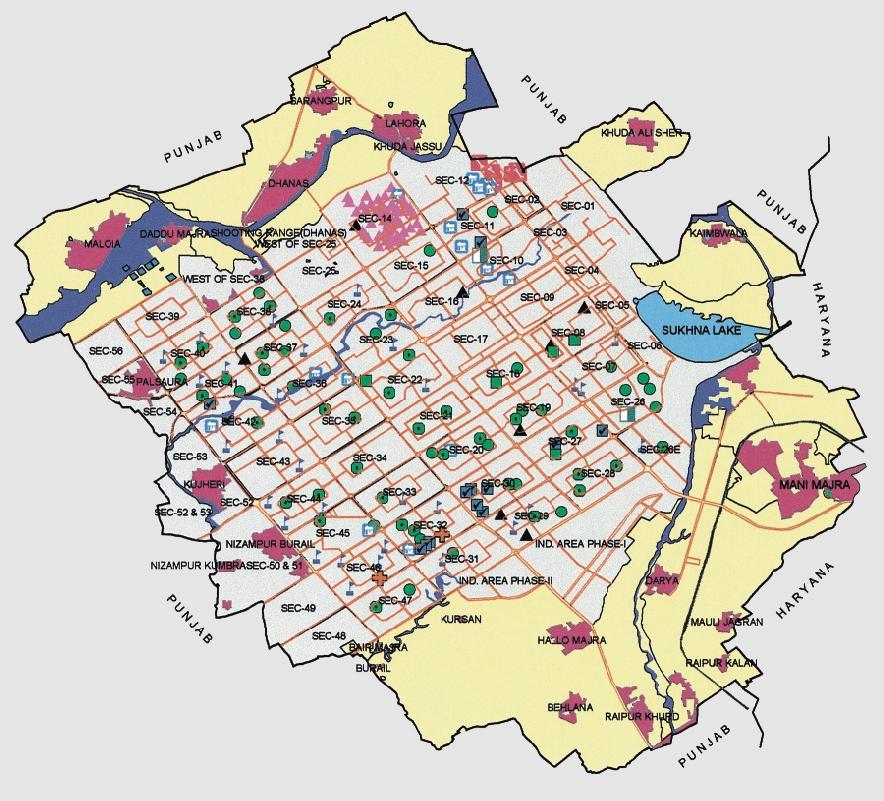
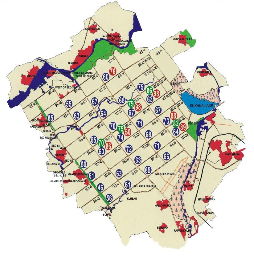
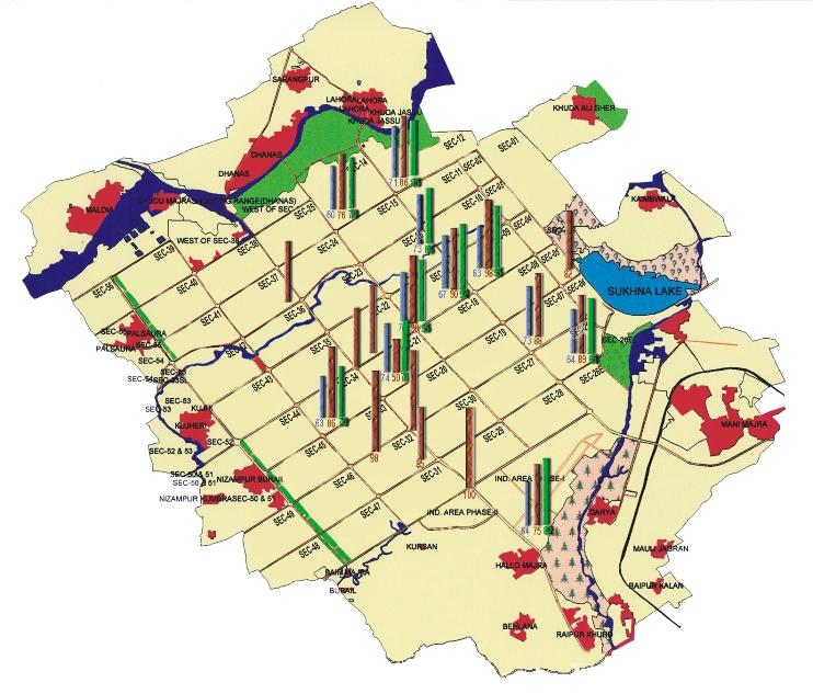
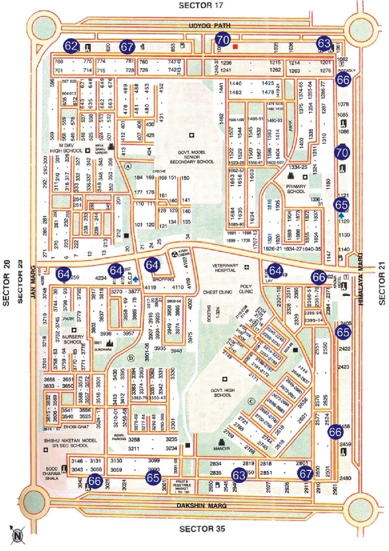
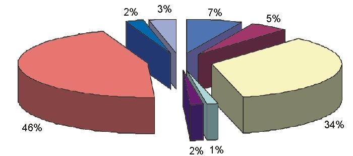
18 Map 1.2 Distribution of various land uses in Chandigarh N W E S NRIS National (Natural Resources Information System) Dept. of Space Sponsored Project Executed By: Punjab Remote Sensing Centre Ludhiana In Technical Collaboration With Regional Remote Sensing Service Centre Dehradun Map1.3 Details of distribution of various land uses in Chandigarh LEGEND N W E S Kilometers 6 2 Kilometers Source : PRSC, Ludhiana Satellite Data: IRS-1D liss-iii + PAN MERGED DATA Date of Pass: 05/03/2001 The distribution of various land uses as per Punjab Remote Sensing Centre, Ludhiana (PRSC) is presented in Maps 1.2 & 1.3. Data indicates that a large portion of the land (about 69.6%) falls under urban category, 5.4% of the area is under village habitation, 7.2 % of the area is under agricultural use, 7.7% under forests & other plantations, 1.6% is under Sukhna Wetland, 3.1% under other water bodies and rest of the area is under vacant land (3.8%) and miscellaneous uses(1.6%). In addition to the above, sq km additional area has been acquired and declared as Sukhna Wetland Sanctuary. Hence, the total area under forests is sq km, out of which sq km area is under hilly forest, 3.90 sq km is under Sukhna Choe forest & PatialaKi-Rao forest and 1.05 sq km of the area is under Lake forest (Map 1.4).
19
20
21
22
23

24
25

26


27
28
29
30
31
32
33
34
35
36
37

38
39
40
41
42
43
44
45
46
47
48
49
50
51
52
53
54
55
56
57
58

59
60
61
62
63
64
65
66
67
68
 DATA: SPOT 1 WATER SPREAD: 142 ha L SUKHNA LAKE Source: PRSC, Ludhiana CHANDIGARH CITY Table 4.")
69 Fig Satellite Image of Sukhna Lake Fig Monitoring of water spread/aquatic vegetation and turbidity of Sukhna Lake A YEAR: 1967 DATA: SOI TOPOSHEET WATER SPREAD 150 ha. N SUKHNA LAKE CHANDIGARH CITY B SEASON: POST MONSOON (OCT 86) DATA: SPOT 1 WATER SPREAD: 142 ha L SUKHNA LAKE Source: PRSC, Ludhiana CHANDIGARH CITY Table 4.5 Variations in water spread (ha) in Sukhna Lake Data Set Year Season SPOT TM LANDSAT TM B/W Aerial Photographs IRS-1A-LISS II IRS-1A-LISS II Post-monsoon Spring Water Spread (ha) C SEASON: PRE MONSOON (MARCH 87) DATA: LANDSAT TM WATER SPREAD: 120 ha M S S Spring Post-monsoon Pre-monsoon SUKHNA LAKE * Total differs from sq km reported elsewhere by Forest Deptt. Source: PRSC,1994 CHANDIGARH D SEASON: POST MONSOON (OCT92) DATA: IRS-1A-LISS I (DIAPOSITIVE) WATER SPREAD 153 ha L The drainage map (Map 4.3) reveals that the drainage pattern is dendritic and sub parallel. The high drainage density in the catchment indicates severe erosion. During the period , the course of Sukhna and Kansal nadis have changed considerably. Further, to check the influx of silt, the course of Kansal nadi was diverted towards Sukhna nadi in 1972 where it merges with it and ultimately feeds the lake. Seasonal variation in water spread of the lake (pre and post monsoon) has also been studied (Table 4.5). Sukhna wetland has also been classified on the basis of turbidity using pre and post-monsoon data of 1986/1987 and 1992/ It has been observed that during postmonsoon season it has low turbidity whereas in premonsoon it has moderate turbidity (Figure 4.13). IMPACTS Frequent change in land use pattern to bring more areas under urbanization, developmental activities and deforestation in the peripheral zone, and generation of high CITY W S W SUKHNA LAKE CHANDIGARH CITY E SEASON: PRE MONS0ON (MAY 1993) DATA: IRS-1A-LISS I (DIAPOSITIVE) WATER SPREAD: 134 ha M V W SUKHNA LAKE CHANDIGARH CITY L E G E N D TURBIDITY CLASSES OF SUKHNA LAKE VEGETATION TURBIDITY SYNBOL L LOW M MODERATE V SCRUB VEGETATION H HIGH S 1 0 W AQUATIC WEEDS 1 2 SILTATION 3 Km Source: PRSC, Ludhiana 57
70
71

72
73
74
75
76
77
78
79
80
81
82
83
84
85
86
87
88
89
90
91
92
93
94
95
96
97
98
99
100


101
Remote Sensing into the Study of Ancient Beiting City in North-Western China
 Dingwall, L., S. Exon, V. Gaffney, S. Laflin and M. van Leusen (eds.) 1999. Archaeology in the Age of the Internet. CAA97. Computer Applications and Quantitative Methods in Archaeology. Proceedings of
India - State-wise Wastelands Distribution (Percentage to total geographical area)
") WASTELAND MAP 25-6 INDIA Figure. 1 Gullied/ Ravine land-medium ravine Gullied/Ravine land-deep/ very deep ravine Scrubland - Land with dense scrub Scrubland - Land with open scrub Waterlogged and marshy
WASTELAND MAP 25-6 INDIA Figure. 1 Gullied/ Ravine land-medium ravine Gullied/Ravine land-deep/ very deep ravine Scrubland - Land with dense scrub Scrubland - Land with open scrub Waterlogged and marshy
Settlement Patterns West of Ma ax Na, Belize
 SETTLEMENT PATTERNS WEST OF MA AX NA, BELIZE 1 Settlement Patterns West of Ma ax Na, Belize Minda J. Hernke Faculty Sponsor: Kathryn Reese-Taylor, Department of Sociology/Archaeology ABSTRACT The focus
Lidar Imagery Reveals Maine's Land Surface in Unprecedented Detail
 Maine Geologic Facts and Localities December, 2011 Lidar Imagery Reveals Maine's Land Surface in Unprecedented Detail Text by Woodrow Thompson, Department of Agriculture, Conservation & Forestry 1 Introduction
SLV POWER PRIVATE LIMITED ANIYUR MINI HYDEL SCHEME (3 X 8 MW = 24 MW) CATCHMENT AREA TREATMENT PLAN
 CATCHMENT AREA TREATMENT PLAN") SLV POWER PRIVATE LIMITED ANIYUR MINI HYDEL SCHEME (3 X 8 MW = 24 MW) CATCHMENT AREA TREATMENT PLAN 1. INTRODUCTION : M/s SLV Power Pvt. Ltd. Is setting up a Mini Hydel Scheme of 24 MW capacity across
SLV POWER PRIVATE LIMITED ANIYUR MINI HYDEL SCHEME (3 X 8 MW = 24 MW) CATCHMENT AREA TREATMENT PLAN 1. INTRODUCTION : M/s SLV Power Pvt. Ltd. Is setting up a Mini Hydel Scheme of 24 MW capacity across
Alternatives Study of Alignment
 Project: 4-lanning of Barhi Rajauli Section of NH-31 Sheet: 1 of 6 Alternatives Study of Alignment 1 Objectives The following objectives were kept in view while locating the alternative bypass alignments:
Coverage of Mangrove Ecosystem along Three Coastal Zones of Puerto Rico using IKONOS Sensor
 Coverage of Mangrove Ecosystem along Three Coastal Zones of Puerto Rico using IKONOS Sensor Jennifer Toledo Rivera Geology Department, University of Puerto Rico, Mayagüez Campus P.O. Box 9017 Mayagüez,
PORTISHEAD BRANCH LINE PRELIMINARY ENVIRONMENTAL INFORMATION REPORT VOLUME 4 APPENDIX Water Receptors
 PORTISHEAD BRANCH LINE PRELIMINARY ENVIRONMENTAL INFORMATION REPORT APPENDIX 17. 3 Water Receptors Contents Section Page 1 Water Receptors... 1-1 1.1 Surface Water Features/Receptors in the Study Area
Observation of cryosphere
 Observation of cryosphere By Sagar Ratna Bajracharya (email: sagar.bajracharya@icimod.org) Samjwal Ratna Bajracharya Arun Bhakta Shrestha International Centre for Integrated Mountain Development Kathmandu,
Monitoring of Mountain Glacial Variations in Northern Pakistan, from 1992 to 2008 using Landsat and ALOS Data. R. Jilani, M.Haq, A.
 Monitoring of Mountain Glacial Variations in Northern Pakistan, from 1992 to 2008 using Landsat and ALOS Data R. Jilani, M.Haq, A. Naseer Pakistan Space & Upper Atmosphere Research Commission (SUPARCO)
LIBRO CAMPOS PROYECTOS EXTRANJEROS 2017
 Página 1 de 8 Fecha de impresión: Referencia: 1 Code: RC-14/17 Name: Save The Earth - Plant a Tree Address: Bandh Patta 173233, C.P. 173233, Sin Localidad, Sin Autonomia, India Project: ENVI-MANU-SOCI
Module 1 Educator s Guide: Representative Discussion Points Investigation 3
 Module 1 Educator s Guide: Representative Discussion Points Investigation 3 Ethiopia and Eritrea Our combined population is 59,578,171 people. We have just emerged from a long period of civil war and famine.
KP Lasnaya 1 River
 KP 370.2 Lasnaya 1 River The Lasnaya 1 River crossing is protected by Reno mattings and a gabion wall on the north bank (Photo 1). The south bank consists of natural river gravel deposits on top of Reno
National Biodiversity Strategy and Action Plan, India
 Final Technical Report of the UNDP-GEF Sponsored Project National Biodiversity Strategy and Action Plan, India Volume 2 Executing Agency Ministry of Environment and Forests, Government of India Technical
Triangle Land Conservancy Conservation Area Monitoring Report Carolina North
 Triangle Land Conservancy Conservation Area Monitoring Report Carolina North Property Name: Bolin Creek West Conservation Area Date of visit: March 16, 2017 County: Orange Property Type: Restrictive Covenants
Header i
 Header i 048285014.10 Header Sub Title Body Text here. Body text here. Body text here. Section 1... 1 Executive Summary... 1 Opportunities and Constraints... 3 Overall Opportunities and Constraints Map
Platform and Products
 International Partnership Space Programme Earth Observation for the Preservation of Ecological Bacalar Corridor Platform and Products Terri Freemantle, Raffaella Guida, Paula Marti, Pasquale Iervolino
Specification for Grip blocking using Peat Dams
 Technical Guidance Note 1 Specification for Grip blocking using Peat Dams 1. Introduction Moorland drains (grips) have been dug across much of the Yorkshire upland peatlands. Many of these grips have become
Applying Geospatial Tools to Produce Data for SDG Indicators in Mexico
 Applying Geospatial Tools to Produce Data for SDG Indicators in Mexico Inter-Agency and Expert Group On SDGs Indicators Enrique Ordaz Francisco J. Jimenez Stockholm November 2018 Background INEGI has produced
Snow, Glacier and GLOF
 Snow, Glacier and GLOF & Report on Demonstration River Basin Activities Upper Indus Basin The 5th International Coordination Group (ICG) Meeting GEOSS Asian Water Cycle Initiative (AWCI) Tokyo, Japan,
Habitat of Large Glaciers and Snow Leopards
 Headwaters of High Mountain Asia - Habitat of Large Glaciers and Snow Leopards International Snow Leopard Day A Collaborative Effort to Assess the Role of Glaciers and Seasonal Snow Cover in the Hydrology
Summary table of disaster occurrences, by hazards types, scale, and geographic region
 ANNEX BASIC RANGE OF DISASTER-RELATED STATISTICS TABLES Statistical tables are organised into worksheets according to basic components in the DSRF. The variables represent queries from a disaster-related
To Mumbai, Back and Forth. Circulatory Urbanism Photo Essay. Photos by Ishan Tankha Text by Rahul Srivastava and Matias Echanove
 To Mumbai, Back and Forth Circulatory Urbanism Photo Essay Photos by Ishan Tankha Text by Rahul Srivastava and Matias Echanove This photo essay is an extract from a study by the Institute of Urbanology.
Triangle Land Conservancy Conservation Area Monitoring Report Carolina North
 Triangle Land Conservancy Conservation Area Monitoring Report Carolina North Property Name: Crow Branch Conservation Area Date of visit: 4/8/2015 County: Orange Property Type: Restrictive Covenants Local
The Potentially Dangerous Glacial Lakes
 Chapter 11 The Potentially Dangerous Glacial Lakes On the basis of actively retreating glaciers and other criteria, the potentially dangerous glacial lakes were identified using the spatial and attribute
Climate Change Impact on Water Resources of Pakistan
 Pakistan Water and Power Development Authority (WAPDA) Climate Change Impact on Water Resources of Pakistan Glacier Monitoring & Research Centre Muhammad Arshad Pervez Project Director (GMRC) Outline of
The Pilcomayo River Basin Argentina
 The Pilcomayo River Basin Argentina Yangareko ( Janis Alcorn, Alejo Zarzycki, Alonzo Zarzycki, Luis Maria de la Cruz) Governance and Ecosystems Management for the CONservation of BIOdiversity www.gemconbio.eu
Glacial Lake Outburst Flood Mitigation Measures, Monitoring and Early Warning Systems
 Chapter 12 Glacial Lake Outburst Flood Mitigation Measures, Monitoring and Early Warning Systems There are several possible methods for mitigating the impact of Glacial Lake Outburst Flood (GLOF) surges,
Brief Description of Northern the West Bank, Palestine Prepared by: Dr. Ahmed Ghodieh Department of Geography An-Najah National University Nablus,
 Brief Description of Northern the West Bank, Palestine Prepared by: Dr. Ahmed Ghodieh Department of Geography An-Najah National University Nablus, Palestine Brief Description of Northern the West Bank
Trappist Monastery Provincial Park. Draft Management Plan
 Trappist Monastery Provincial Park Draft Management Plan 2 Trappist Monastery Provincial Park Table of Contents 1. Introduction... 3 2. Park History... 3 3. Park Attributes... 3 3.1 Natural... 3 3.2 Recreational...
How Internet can be used for climate change monitoring, early warning and mitigation in the Himalayas? Guarab Raj Upadhaya
 How Internet can be used for climate change monitoring, early warning and mitigation in the Himalayas? Guarab Raj Upadhaya Nepal Wireless Project Nepal Research & Education Network December 4, 2008 My
Development of Ski Resorts in the Indian Himalayas
 Development of Ski Resorts in the Indian Himalayas AMITABH SHARMA SKI HIMALAYAS # 1 Pocket 52, C.R Park New Delhi 110019 +91-9816055555 Email : amitabhsharma_manali@rediffmail.com The Himalayas are a vast
KKC can provide the total solution from Data capturing to Consulting
 Crowdsource Mapping Response to the Great East Japan Earthquake Kunihiro ISHII kunihiro_ishii@kk-grp.jp Business Fields of KOKUSAI KOGYO(KKC) KKC can provide the total solution from Data capturing to Consulting
Spatial Distribution and Characteristics of At-Risk Species in the Southeast U.S.
 Nicholas Institute for Environmental Policy Solutions Scoping Document Part 2 Exploratory Analysis of Characteristics and Trends of At-Risk Species in the Southeast U.S. Spatial Distribution and Characteristics
Disaster Prevention Monitoring in a Vulnerable Environment Mahabir Pun
 Disaster Prevention Monitoring in a Vulnerable Environment Mahabir Pun Nepal Wireless Project Nepal Research & Education Network 14 April 2008, Japan My Involvement Chairman, the Institute for Himalayan
KAMPALA: THE GARDEN CITY
 KAMPALA: THE GARDEN CITY Kampala is urbanizing rapidly. The city has a population of over three million people and accounts for over sixty percent of Uganda's GDP. According the to the Kampala City Council
ANALYSIS OF INADEAUTE WATER QUALITY OD THE RESERVOIR VONARJE/SUTLA LAKE AND POSSIBILITY OF RESTORATION AND UTILIZATION
 EC project on Integration of Natural Water Retention Measures in river basin management The 1 st Danube Region Workshop ANALYSIS OF INADEAUTE WATER QUALITY OD THE RESERVOIR VONARJE/SUTLA LAKE AND POSSIBILITY
EO-based services to support humanitarian operations: monitoring population and natural resources in refugee/idp camps
 How satellites can help to save lives Vienna, Austria 23 February 2016 EO-based services to support humanitarian operations: monitoring population and natural resources in refugee/idp camps Petra FÜREDER
The dynamic response of Kolohai Glacier to climate change
 Article The dynamic response of Kolohai Glacier to climate change Asifa Rashid 1, M. R. G. Sayyed 2, Fayaz. A. Bhat 3 1 Department of Geology, Savitribai Phule Pune University, Pune 411007, India 2 Department
Boatswain bay biodiversity reserve
 Boatswain bay biodiversity reserve March 2003 1 1. Plan and description 1.1. Geographic location, boundaries and dimensions The plan of the proposed Boatswain bay biodiversity reserve and its location
CHAPTER III: TRAIL DESIGN STANDARDS, SPECIFICATIONS & PERMITS
 CHAPTER III Trail Design Standards, Specifications & Permits This chapter discusses trail standards, preferred surface types for different activities, permits, and other requirements one must consider
ASSESSING THE EFFECTS OF GEOSPATIAL FEATURES ON BIRD STRIKE OCCURRENCES AT SELECTED AIRPORTS IN THE US INTRODUCTION
 ASSESSING THE EFFECTS OF GEOSPATIAL FEATURES ON BIRD STRIKE OCCURRENCES AT SELECTED AIRPORTS IN THE US Frederick K. Wilson, Research Scientist/Lecturer Judy Jackson-Pringle, Research Associate School of
Geological Report on Limestone Exploration Of Bhatvadiya Block Of EXECUTIVE SUMMARY
 Geological Report on Limestone Exploration Of Bhatvadiya Block Of Kalyanpur Taluka, Devbhumi Dwarka District, Gujarat. EXECUTIVE SUMMARY Prepared for: Gujarat Mineral Research & Development Society Government
CRI Loreto. IIAP crew seining for Colossoma macropomum broodstock at the CRI Loreto research site in Peru.
 PERU CRI Loreto 43 PD/A CRSP SITE DESCRIPTIONS CRI Loreto Marcos J. De Jesús Marcos J. De Jesús IIAP crew seining for Colossoma macropomum broodstock at the CRI Loreto research site in Peru. Hatchery facilities
SIAVONGA DISTRICT
 SIAVONGA DISTRICT --------------------------------------------------------------------------------------------------------- 1.0 Physical Environment Siavonga District is characterized by an escarpment
Robson Valley Avalanche Tract Mapping Project
 Robson Valley Avalanche Tract Mapping Project Prepared for: Chris Ritchie Ministry of Water Land and Air Protection 325 1011 4th Avenue Prince George, BC. V2L3H9 and Dale Seip Ministry of Forests 1011
Appendix 2 - Schedule of District Regulations
 RESIDENTIAL RECREATION DISTRICT (RR) INTENT: This district is intended to provide areas for growth/development of the Town at a modest density. The district provides for certain uses which, though low
Chuckanut Ridge Fairhaven Highlands EIS Scoping Concerns
 Chuckanut Ridge Fairhaven Highlands EIS Scoping Concerns Coalition of Southside Neighborhoods CSN Comments for Fairhaven Highlands EIS Scope Hearing, Jan 16, 2008 1 Chuckanut Ridge Hilly Terrain: Potential
Trappist Monastery Provincial Park. Management Plan
 Trappist Monastery Provincial Park Management Plan 2 Trappist Monastery Provincial Park Table of Contents 1. Introduction... 3 2. Park History... 3 3. Park Attributes... 4 3.1 Natural... 4 3.2 Recreational...
Africa. At A Glance. Sites for Africa
 1 Africa At A Glance Population: 812 million Percent of World s Population: 13.2% Land area: 30,065,000 sq km Percent of Earth s Land: 20.2% Key Environmental Issues: Land degradation Desertification Deforestation
MONITORING OF LAKE NASSER USING REMOTE SENSING AND GIS TECHNIQUES
 MONITORING OF LAKE NASSER USING REMOTE SENSING AND GIS TECHNIQUES M. M. Mostafa a and H. K. Soussa b a Information Technology Institute, GIS department - mostafam@mcit.gov.eg b Ain Shams University, Faculty
Monitoring the Environmental Status of the Heart of Borneo
 Monitoring the Environmental Status of the Heart of Borneo By: Stephan Wulffraat The Heart of Borneo conservation initiative has been going on now for several years and has gained increasing support from
Sardar Patel National Highways Modern Dharmshala
 () (A Pilot Project for Coastal Districts in India) Presented by: Coastal India Development Council (CIDC India) About CIDC India: Coastal India Development Council (CIDC) is a society to develop the core
Brazil. Chapter 12. Chapter 12, Section
 Chapter 12, Section World Geography Chapter 12 Brazil Copyright 2003 by Pearson Education, Inc., publishing as Prentice Hall, Upper Saddle River, NJ. All rights reserved. Chapter 12, Section World Geography
VISUAL Impact Assessment
 5.0 Existing Landscape Character TO GOULBURN FEDERAL HIGHWAY 5.1 Landscape Character Units Generally one of the first steps in carrying out a landscape and visual assessment is to identify and map the
Do Scenic Amenities Foster Economic Growth in Rural Areas?
 Do Scenic Amenities Foster Economic Growth in Rural Areas? By Jason Henderson and Kendall McDaniel Rural areas in the Tenth District are experiencing a period of renewed economic growth in the 199s. After
Unmanned Aircraft Systems (UAS) at the Jornada Experimental Range
 at the Jornada Experimental Range") Unmanned Aircraft Systems (UAS) at the Jornada Experimental Range Al Rango and the Jornada UAS Flight Team: Connie Maxwell, Amy Slaughter, Andrea Laliberte, Chris Pierce, Dave Thatcher, Jim Lenz, and Craig
Unmanned Aircraft Systems (UAS) at the Jornada Experimental Range Al Rango and the Jornada UAS Flight Team: Connie Maxwell, Amy Slaughter, Andrea Laliberte, Chris Pierce, Dave Thatcher, Jim Lenz, and Craig
2006 WEEKDAY TRAFFIC PROFILE. June 15, 2007
 June 15, 2007 Mr. Gary Stobb, P.E. Director of Planning/Operations Harris County Toll Road Authority 330 Meadowfern, Suite 200 Houston, TX 77067 Re: Westpark Tollway Value Pricing Analysis Dear Mr. Stobb:
ETS Park & Ride Report Summer 2017
 Urban Form And Corporate Strategic Development City Planning 8th Floor, Edmonton Tower 10111-104 Avenue NW Edmonton, AB T5J 0J4 Tel.: 780.496.6086 Email: varjinder.chane@edmonton,ca ETS Park & Ride Report
LAKE MERCED November 6, 2013
 LAKE MERCED November 6, 2013 Agenda Welcome and Introductions Harding Road Boathouse Updates Lake Merced Water Level Management Pacific Rod and Gun Club Site Cleanup Community Planning Process for Lake
Spatial Assessment for the revised Mpumalanga Biodiversity Expansion Strategy. Mervyn Lotter Scientific Services 8 June 2016
 Spatial Assessment for the revised Mpumalanga Biodiversity Expansion Strategy Mervyn Lotter Scientific Services 8 June 2016 Mpumalanga Protected Area Expansion Strategy (MPAES) Developed our first MPAES
THE STATUS OF DORCAS GAZELLE IN ETHIOPIA
 THE STATUS OF DORCAS GAZELLE IN ETHIOPIA Paper presented in the second workshop on the conservation and restoration of Sahelo-Saharan Antelopes. 1-5 May 2003 by Mohammed Ali and Ababu Ange Zeleke May /
Conservation of Critical Environmental Resources in Chatham Park
 Conservation of Critical Environmental Resources in Chatham Park Elaine Chiosso, Haw Riverkeeper Haw River Assembly Haw River As Seen From Chatham Park "Spreading southwestward from the banks of the Haw
EVALUATION OF DIFFERENT METHODS FOR GLACIER MAPPING USING LANDSAT TM
 EVALUATION OF DIFFERENT METHODS FOR GLACIER MAPPING USING LANDSAT TM Frank Paul Department of Geography, University of Zurich, Switzerland Winterthurer Strasse 190, 8057 Zürich E-mail: fpaul@geo.unizh.ch,
Triangle Land Conservancy Conservation Area Monitoring Report Carolina North
 Triangle Land Conservancy Conservation Area Monitoring Report Carolina North Property Name: Bolin Creek East Conservation Area Date of visit: March 16, 2017 County: Orange Property Type: Restrictive Covenants
Friday, November 10, 2017
 Friday, November 10, 2017 Andes and Midlatitude Countries Objective: Summarize the main physical features and regions of the Southern Cone. Identify and locate the urban centers and understand the pattern
The Geography of Tourism Employment
 The Geography of Tourism Employment Coverage: UK Date: 23 November 2012 Geographical Area: European (NUTS) Theme: People and Places Theme: Labour Market Key Points There were 2.7 million persons with jobs
Silvia Giulietti ETIS Conference Brussels An EEA reporting mechanism on tourism and environment and ETIS
 Silvia Giulietti ETIS Conference Brussels 28.01.2016 An EEA reporting mechanism on tourism and environment and ETIS Main content Why tourism and environment? Why a reporting mechanism on tourism and environment
Triangle Land Conservancy Conservation Area Monitoring Report Carolina North
 Triangle Land Conservancy Conservation Area Monitoring Report Carolina North Property Name: Crow Branch Conservation Area Date of visit: March 16, 2016 County: Orange Property Type: Restrictive Covenants
Theme: Predominately natural/natural appearing; rustic improvements to protect resources. Size*: 2,500 + acres Infrastructure**:
 Recreation Opportunity Spectrum (ROS) Classes The Recreation Opportunity Spectrum (ROS) provides a way to describe the variations in the degree of isolation from the sounds and influences of people, and
ZONING OF FLOOD PRONE AREAS IN THE ERSTWHILE BARPETA DISTRICT OF ASSAM, INDIA
 J. Assam Sc. Soc. ISSN : 0587-1925 Vol. 56, No. 1; June 2015, pp.96-106 ZONING OF FLOOD PRONE AREAS IN THE ERSTWHILE BARPETA DISTRICT OF ASSAM, INDIA Naba Kumar Talukdar 1 and *Sarbeswar Kalita 2 1 Department
The Inventory of Glacial Lakes
 Chapter 8 The Inventory of Glacial Lakes 8.1 BRIEF DESCRIPTION OF GLACIAL LAKE INVENTORY The inventory of glacial lakes has been systematically carried out using topographic maps. As not all the topographic
Possible location of Gaspar Dias fort in relation to the present river bank, Mandovi estuary, Goa, India
 Citation: Recent Researches on Indus Civilization & Maritime Archaeology in India. ed by: Gaur, A.S.; Sundaresh,; Agam Kala Prakashan.New Delhi; 2015; 207-218 Abstract Possible location of Gaspar Dias
POPULATION DISTRIBUTION AND DENSITY IN TANZANIA: EXPERIENCES FROM 2002 POPULATION AND HOUSING CENSUS
 POPULATION DISTRIBUTION AND DENSITY IN TANZANIA: EXPERIENCES FROM 2002 POPULATION AND HOUSING CENSUS 1.0. Introduction By Ndalahwa F. Madulu Institute of Resource Assessment University of Dar es Salaam
GOOSENECK SWAMP INFORMATION DAY - Saturday 14 th December 2013
 GOOSENECK SWAMP INFORMATION DAY - Saturday 14 th December 2013 Progress of a restoration trial at Gooseneck Swamp - Grampians National Park, Victoria Gooseneck Swamp is situated at the far south-eastern
INTRODUCTION 250,000
 INTRODUCTION The United States of America has over 250,000 rivers, with a total of about 3,500,000 miles of rivers. The main stems of 38 rivers in the United States are at least 500 miles (800 km) long.
STUDY AREA. Geo-Ecological setting of the study site:
 STUDY AREA Geo-Ecological setting of the study site: The Manipur State is located in the mid of highly diverse Biological region of the Indo- Burma mega diversity Hot-spot zone of the world. The area is
COORDINATE SYSTEM MGA Z56 FIG NO FIGURE TITLE Estuary zones of the Georges River Catchment PAGE SIZE A3 DATE 13/04/2010 SCALE 1:70,000
 FAIRFIELD LGA Estuary Zones Marine Tidal Delta Central Mud Basin Fluvial Delta Riverine Channel Freshwater Reach Study Area LGAs NORTH BOTANY BAY 0 1 2 4 DATE 13/04/2010 1:70,000 Kilometers PAGE SIZE A3
SAPPORO INTERNATIONAL ART FESTIVAL
 SAPPORO INTERNATIONAL ART FESTIVAL 2012.DEC Creative City Sapporo International Art Festival Executive Committee SAPPORO INTERNATIONAL ART FESTIVAL G r e e t i n g s The global economic crisis and the
IMPORTANT DEFINITIONS DEFINITIONS FROM TOPO MAPS
 IMPORTANT DEFINITIONS DEFINITIONS FROM TOPO MAPS 1. REPRESENTATIVE FRACTION (RF): It is the ratio between the distances on the map to its corresponding distance on actual ground. The RF on this map is
USDA Forest Service Deschutes National Forest DECISION MEMO. Round Lake Christian Camp Master Plan for Reconstruction and New Facilities
 USDA Forest Service Deschutes National Forest DECISION MEMO Round Lake Christian Camp Master Plan for Reconstruction and New Facilities Jefferson County, Oregon T. 13 S., R. 8 E., Section 16, W.M. Background:
Final Research Progress Report: 9 August 2011
 Final Research Progress Report: 9 August 2011 Funds approved in current fiscal year: $ 26,058 Project contract number: CAC # 65103 Project title: Surveying Avocados in the Baja Peninsula for Pests that
Other Principle Arterials Minor Arterial Major Collector Minor Collector Local
 CHAPTER 10 TRANSPORTATION Introduction The system of public roads in East Pikeland Township is decidedly rural in character. Since the 1984, the road network has remained much the same, with the addition
Logo Department Name Agency Organization Organization Address Information 5700 North Sabino Canyon Road
 Logo Department Name Agency Organization Organization Address Information United States Forest Coronado National Forest 5700 North Sabino Canyon Road Department of Service Santa Catalina Ranger District
Preparing Baseline Documentation for your Protected Lands
 Preparing Baseline Documentation for your Protected Lands December 7, 2013 William Hall Free Library Cranston, RI Carol Lynn Trocki, Conservation Biologist Sponsored by Rhode Island Land Trust Council
Yard Creek Provincial Park. Management Plan
 Yard Creek Provincial Park Management Plan Draft January 2010 Yard Creek Provincial Park Management Plan Approved by: telàlsemkin/siyam/chief Scott Benton Bill Williams Squamish Executive Director ation
INTRODUCTION TO TOPOSHEETS-45D/7 AND 45D/10
 INTRODUCTION TO TOPOSHEETS-45D/7 AND 45D/10 PROFILE OF SURVEY MAP 45 D/7 DESCRIPTION of the Area covered by Survey Sheet No. 45 D/7 (Gujarat and Rajasthan) District : Banas Kantha and Sirohi Location:
Climate Change Adaptation in
 Climate Change Adaptation in the Hindu Kush Himalaya Experience from the Great Himalaya Trail My Climate Initiative ----------------------- ----------------------- PARIBESH PRADHAN Overview The Great Himalaya
Protected Areas Management Experience in Jamaica Brief
 Protected Areas Management Experience in Jamaica Brief Case Study CBD Workshop, Barbados 1-5 April 2012 By Bernard Blue, National Environment and Planning Agency What is a Protected Area? A Protected Area
Using UAS Technology for Invasive Plant Management
 Using UAS Technology for Invasive Plant Management Adam Benjamin, P.S.M. UF/IFAS Fort Lauderdale R.E.C. May 8, 2018 2018 Aquatic Weed Control Short Course Coral Springs, FL Using UAS Technology for Invasive
Commission SUMMARY: 12, Action. review. hearing is. being. 601 E Kennedy Blvd., 18
 Hillsborough County City-Countyy Planning Commission 601 E Kennedy Blvd., 18 th floor, Tampa, Florida, 33601 813-272-5940 theplanningcommission.org EXECUTIVE SUMMARY Meeting Date: August 12, 2013 Agenda
IMPACTS OF CLIMATE CHANGE: GLACIAL LAKE OUTBURST FLOODS (GLOFS)
") IMPACTS OF CLIMATE CHANGE: GLACIAL LAKE OUTBURST FLOODS (GLOFS) Binay Kumar and T.S. Murugesh Prabhu ABSTRACT Worldwide receding of mountain glaciers is one of the most reliable evidences of the changing
IMPACTS OF CLIMATE CHANGE: GLACIAL LAKE OUTBURST FLOODS (GLOFS) Binay Kumar and T.S. Murugesh Prabhu ABSTRACT Worldwide receding of mountain glaciers is one of the most reliable evidences of the changing
Integrated Applications Programme (IAP) & Space for UAS UAS for Applications
 & Space for UAS UAS for Applications") ESA s Integrated Applications Programme (IAP) & Space for UAS UAS for Applications M. Vaissiere ESA Director of Telecommunications and Integrated Applications Programme European High Level UAS Conference
ESA s Integrated Applications Programme (IAP) & Space for UAS UAS for Applications M. Vaissiere ESA Director of Telecommunications and Integrated Applications Programme European High Level UAS Conference
Using of space technologies for glacierand snow- related hazards studies
 United Nations / Germany international conference on International Cooperation Towards Low-Emission and Resilient Societies Using of space technologies for glacierand snow- related hazards studies Bonn,
Stephens State Park Trails
 TRAILS OF ALLAMUCHY MOUNTAIN & STEPHENS STATE PARKS Allamuchy Mountain and Stephens State Parks contain 28 marked trails providing access to diverse landscapes for walking, hiking, biking, bird-watching,
City of Durango 5.8 FUNDING TRAILS DEVELOPMENT
 5.8 FUNDING TRAILS DEVELOPMENT The City has been successful in establishing dedicated local funding sources as well as applying for grants to develop the City s trail system, having received nearly $2.4
Sandbag Barrier. Suitable Applications Sandbag barriers may be suitable: As a linear sediment control measure:
 Categories EC Erosion Control SE Sediment Control TC Tracking Control WE Wind Erosion Control Non-Stormwater NS Management Control Waste Management and WM Materials Pollution Control Legend: Primary Category
Karnataka Evaluation Policy and Karnataka Evaluation Authority
 Karnataka Evaluation Policy and Karnataka Evaluation Authority Evaluation Policy, 2000 & Guidelines, 2003 1. All schemes with a budget outlay of Rs. 5 crore and above should be evaluated at least once
2016 Trails Maintenance and Operating Costs
 2016 Trails Maintenance and Operating Costs Motorized Trails Maintenance for motorized trails comes from vehicle registration fees and a portion of the federal Recreation Trails Program (RTP) funds. The
GEOSPATIAL ANALYSIS OF GLACIAL HAZARDS PRONE AREAS OF SHIGAR AND SHAYOK BASINS OF PAKISTAN. By Syed Naseem Abbas Gilany
 GEOSPATIAL ANALYSIS OF GLACIAL HAZARDS PRONE AREAS OF SHIGAR AND SHAYOK BASINS OF PAKISTAN By Syed Naseem Abbas Gilany PRESENTATION OUTLINE Introduction Problem Statement / Rationale Objectives Material