By Qurat Malik
|
|
|
- Samson Dean
- 6 years ago
- Views:
Transcription


1 By Qurat Malik
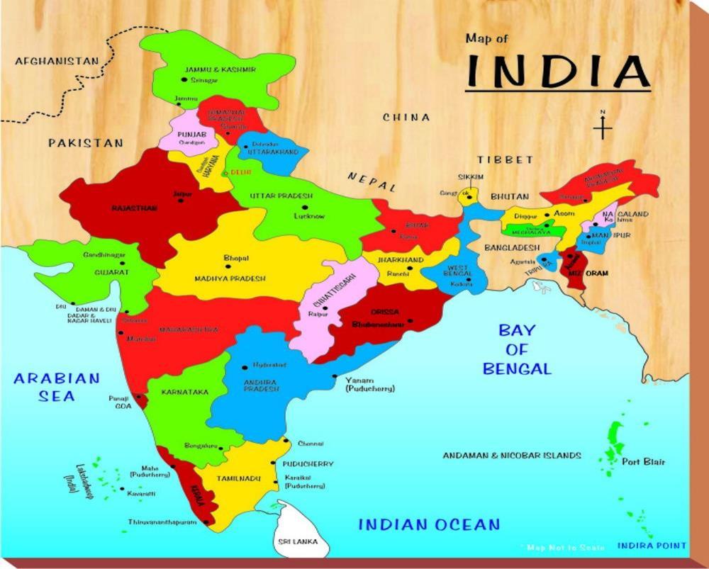
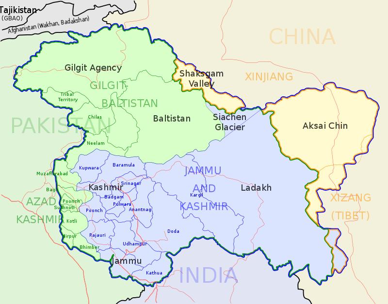
2 Introduction Jammu and Kashmir is the Northern most state of India. Jammu and Kashmir state is located between the latitudes of N and 37 6 N, and the longitudes of E and E. It is bounded by Tibet in the North east, China in the North and Afghanistan in North West. State total area:- 222,236 sq km State total population:- 12,541,302 (according to 2011 census)
3
4
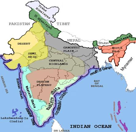
5 Physical division of the state Sub-Himalayan Jammu Himalayan Kashmir Trans-Himalayan Ladakh
6
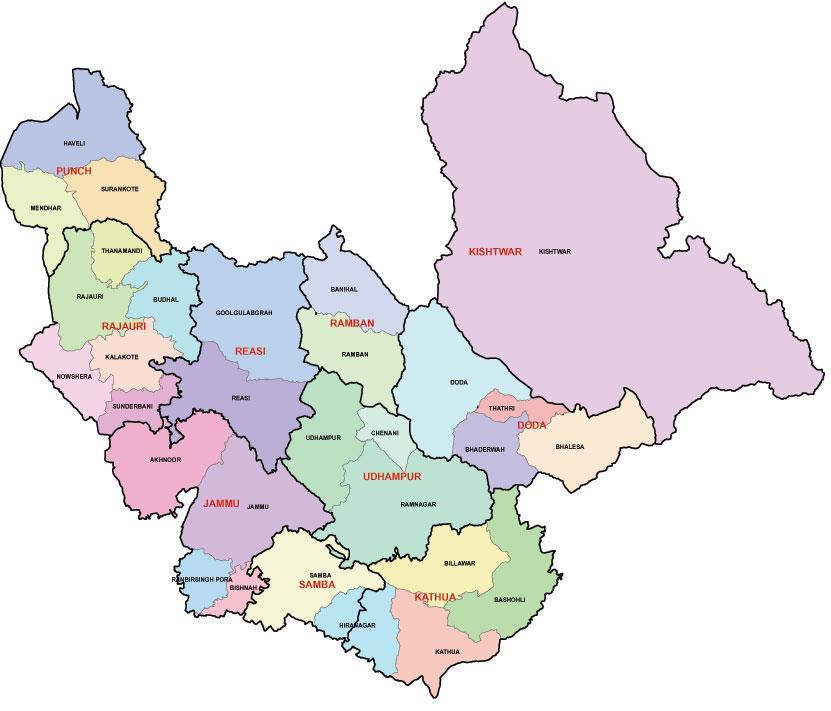
7 Sub Himalayan Jammu(physical features) Background : According to the Gulab Nama of Diwan Kirpa Ram, the territory designated as jammu was ruled by rajas of Raghuvanshi Dynasty. One of its rulers, Agnivarman, had settled near kathua, but his descendants extended the kingdom to Jammu. Two sons of Raja Agnigarb, Bahu Lochan and Jambu Lochan founded the two towns of Bahu and Jammu.
8 Sub Himalyan Jammu can be bifurcated into outer plains, siwaliks and jammu mountains Outer plains : The outer plain of Jammu & Kashmir are a part of Great Plains of India. It extends from kathua in the south, through Hiranagr, Bhishna, Akhnoor, Bhimber upto Mirpur in the west.
9
10 Situated in the vicinity of Siwaliks, the outer plain of jammu division is traversed ny numerous hill torrents, locally known as khadd. These torrents remain dry over trhe greater parts of the winter and summer seasons and attain enormous size during rains.
11
12 These ravines then achieve the shape of gushing torrents. The channel of these torrents are charactrized by clumps of reed growth known as khar. Apart from the parched, stony and brown wilderness of the ravines, the jammu plain comprises large expanses of cropland with deep, fertile alluvial soils.
13 This productive agricultural tract is locally referred to as Anderwah and bajwat. Largest hectarage of this arable land is present in the tehsils of kathua, Hiranagar, Bishnah, R.S Pora, Jammu and Akhnoor. Chief crops raised are rice in Kharif and wheat in Rabi season.
14 Siwaliks: The relatively low outermost hills of the Himalayas along its whole length from Indus to Brahmaputra are known as Siwaliks. The Siwaliks are stretched at a distance of about 200 km between the Ravi and the Jhelum rivers. The Siwaliks rise from the plains of Punjab, commencing with a gentle slope from jammu, attain about 600 m in altitude and then end abruplty in steep, almost perpendicular escarpments inwards.
15
16
17 The southern slopes of the Siwaliks are gentle, covered with deciduous forests, evergreen bushes and numerous scrubs. The northern slopes are steep with thin cover of vegetation. In the Siwaliks to the east of Jammu City are situated the Mansar and Surinsar lakes at an altitude of about 600 m above the seal level. The longitudinal valleys between lesser Himalayas and Siwaliks are known as duns.(udhampur, kotli)
18 The lower slopes of the Siwaliks upto an altitude of 700m from Ravi to Chenab and beyond to Reasi constitute the Kandi area. The belt is characterised by numerous torrents, hilly soils and scarcity of water and agriculture is largely dependent on rains. Kandi inhabitants include the gujjars who are called Doodhia-gujjars. Economically, this is the most under developed part of the state.
19
20 Jammu city is situated on the southern slope of Siwaliks. Jammu city is the winter capital of Jammu and Kashmir. The city is spread over to both banks of the river Tawi and covers the siwalik hills as well as the Jammu plain
21 Jammu mounatins or The Pahar: In the Jammu region the space between the Siwaliks and the Middle Himalaya is occupied by a mountainous tract which is locally known as PAHAR. They extend from the river Ravi to Jehlum. In the south east the range has a width of 65km which decreases to 16 km or more in the west.
22 It passes through Malothi, Mahadev, Chenani, Kud, Batote, Gool Gulab Garh, Rajouri, poonch. Kali Kundi glacier is also found here. In the mountain rim is situated a lakelet called kaplash kund. Every alternate year it becomes the destination of Wasiqi nag Yatra which starts from Baderwah.
23
24 The south eastern parts of Jammu Mountains along the border with chamba district of Himachal Pradesh, are inhabited by a Hindu pastoral community called the Gaddis. The Gaddis are concentrated in the eastern part of the Pahar region, while the remaining stretch, in the west is inhabited by the Muslim gujjars and Bakerwals.
25 Both Baderwah and kishtiwar share some of the features of kashmir like climate and vegetaion. Outside Kashmir, Kishtewar is the only place where safforn is cultivated. Kud and Batote are two hill stations in the Pahar Region. Patni top, at an elevation of 1950 m, is the highest point over which the srinagar-jammu national highway passes.
26 At Tanger, a branch ridge runs South West.This branch is known as Trikuta Mountain. The sacred cave of Vaishno Devi is situated on the peak of Trikuta Mountain. In the Pahar reion, are situated a number of scenic spots. The valley of surankote, in poonch district is known for its 20m high waterfall Noorichamb.
27 The Jammu mountains stretch beyond from poonch to Uri.
28 Drainage The main rivers of Jammu region are Chenab and Ravi. The Manawar Tawi and the (Jammu)Tawi are the tributary streams of the chenab.
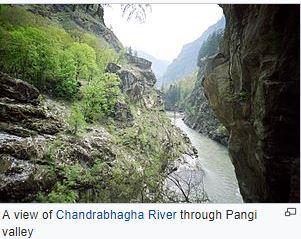
29 Chenab Two streams, the Chandra and the Bhaga, rise from the snowfields of the Lahaul district of Himachal Pradesh. These two streams join together near Tandi. The combined river after flowing through pangi valley, enters Jammu and Kashmir at its south eastern corner, in Kishtiwar district. The Ancient name of the river as mentioned in Rigveda is Askini.
30
31 The Mahabharta and Nilamat purana of Kashmir refer to it as Chanderbhaga.Ptolemy called it as Sandabhaga. The river came to be called as Chenab during medieval period. The first bend in the river is observed at Bhanderkote where it is joined by Marwah stream in the North. The river cascades down, in steps, with a loud roar through a height of 200m. This large drop in elevation has been utilized for the generation of 390 MW of electricity in the Dul-Hasti project.
32 Baglihar power project has also been also constructed on this river,with the power generation capacity of 450 MW. After passing through siwaliks the river enters the plain stage at Akhnoor.
33 Ravi It rises in chamba district of Himachal Pradesh and flows through Brahmpur, Dalhousie, Basohli, and Madhopur. A road bridge and a railway bridge over the Ravi connect j&k through Madhopur corridoe with the rest of the country. Here you will find Ranjit Sagar dam, with the power generating capacity of 600 MW.
34 Manawar Tawi. It originates fron the southern slopes of the Rattan range in the Rajauri district. It passes through Thana Mandi, Rajauri and nowshera and finally joins the Chenab near Manawar town, hence the name.
35 Jammu Tawi Tawi rises in the glaciated alpine meadow of Seoj. A fraction of the catchment in the upper part is snowbound by virtue of which the Tawi maintains a certain volume of water through out the year. It is joined by nine tributaries. One important tributary which joins it on the right bank is the Jajjar Nala. A famous tourist spot Jajjar Kotli has been constructed here.
36 The Chenani Hydroelectric Project, produces 18 MW of electricity is constructed here. Tawi water irrigates the cropland in the district of jammu and Udhampur. Tawi fulfills the water requirements of Jammu city.it joins chenab in Pakistan
OUR COUNTRY INDIA L OCATIONAL SETTING
 7 India is a country of vast geographical expanse. In the north, it is bound by the lofty Himalayas. The Arabian Sea in the west, the Bay of Bengal in the east and the Indian Ocean in the south, wash the
Introduction. Administrative Divisions
 Introduction The state of Jammu and Kashmir constitutes northern most extremity of India and is situated between 32 o 17 to 36 o 58 north latitude and 37 o 26 to 80 o 30 east longitude. It falls in the
PHYSIOGRAPHIC DIVISION OF INDIA
 PHYSIOGRAPHIC DIVISION OF INDIA INTRODUCTION India is vast country there have great diversity in it s physical features. Physical Division Of India are divided into following five Division. 1. The Northern
Development of Ski Resorts in the Indian Himalayas
 Development of Ski Resorts in the Indian Himalayas AMITABH SHARMA SKI HIMALAYAS # 1 Pocket 52, C.R Park New Delhi 110019 +91-9816055555 Email : amitabhsharma_manali@rediffmail.com The Himalayas are a vast
JT2 LAHESH CAVE TRAIL. A chance to experience nature at its best..
 JT2 LAHESH CAVE TRAIL A chance to experience nature at its best.. Just close your eyes and imagine for a minute.. The mighty and imposing Dhauladhar Himalayan ranges in the backdrop, complete with snow
XXI-TOURISM. Table No Tourists coming to Kashmir Valley
 359 I DIGEST OF STATISTICS 2014-15 Table No. 21.00 Tourists coming to Kashmir Valley (000 Nos.) S.No. Year Indian Non-Indian Total 1 2 3 4 5 1. 1951 9.33 1.25 10.58 2. 1955 48.19 2.83 51.02 3. 1960 63.37
Climate Change and State of Himalayan Glaciers: Issues, Challenges and Facts
 Climate Change and State of Himalayan Glaciers: Issues, Challenges and Facts D.P. Dobhal dpdobhal@wihg.res.in Wadia Institute of Himalayan Geology Dehra Dun Major Issues Are the Himalayan glaciers receding
Mountain Passes in Himalayas : India
 Mountain Passes in Himalayas : India Overall, the Himalayan mountain system is the world s highest, and is home to the world s highest peaks, the Eightthousanders. There are 14 Himalayan peaks with elevation
Remoteness Basho valley is a rather remote area in the Western Himalayan mountain range. From Islamabad it is a two day drive by car.
 Remoteness Basho valley is a rather remote area in the Western Himalayan mountain range. From Islamabad it is a two day drive by car. The first part of the journey follows the KKH along the ancient silk
SIAVONGA DISTRICT
 SIAVONGA DISTRICT --------------------------------------------------------------------------------------------------------- 1.0 Physical Environment Siavonga District is characterized by an escarpment
The Geological Pacific Northwest. Wednesday February 6, 2012 Pacific Northwest History Mr. Rice
 The Geological Pacific Northwest Wednesday February 6, 2012 Pacific Northwest History Mr. Rice 1 Free Response #2 Please do not simply list the items for this response. Full sentences!!! Minimum of 3-5
Stok Kangri Peak (6120m) 2 to 16 September 2018 Explore the hidden kingdom of Ladakh with Stok Kangri Peak
 2 to 16 September 2018 Explore the hidden kingdom of Ladakh with Stok Kangri Peak") Stok Kangri Peak (6120m) 2 to 16 September 2018 Explore the hidden kingdom of Ladakh with Stok Kangri Peak Stok Kangri is a perfect objective for fit trekkers without climbing experience, and is one of
Stok Kangri Peak (6120m) 2 to 16 September 2018 Explore the hidden kingdom of Ladakh with Stok Kangri Peak Stok Kangri is a perfect objective for fit trekkers without climbing experience, and is one of
The Himalayan Future Transition, Equity and Ecological Stability. Jayanta Bandyopadhyay
 The Himalayan Future Transition, Equity and Ecological Stability Jayanta Bandyopadhyay Himalaya the Mountain of Diversity The Himalaya has been mentioned in many writings, both ancient and modern, scientific
Chapter 7 Geography and the Early Settlement of Egypt, Kush, and Canaan
 Chapter 7 Geography and the Early Settlement of Egypt, Kush, and Canaan How did geography affect early settlement in Egypt, Kush, and Canaan? Section 7.1 - Introduction RF/NASA//Corbis This satellite photograph
SLV POWER PRIVATE LIMITED ANIYUR MINI HYDEL SCHEME (3 X 8 MW = 24 MW) CATCHMENT AREA TREATMENT PLAN
 CATCHMENT AREA TREATMENT PLAN") SLV POWER PRIVATE LIMITED ANIYUR MINI HYDEL SCHEME (3 X 8 MW = 24 MW) CATCHMENT AREA TREATMENT PLAN 1. INTRODUCTION : M/s SLV Power Pvt. Ltd. Is setting up a Mini Hydel Scheme of 24 MW capacity across
SLV POWER PRIVATE LIMITED ANIYUR MINI HYDEL SCHEME (3 X 8 MW = 24 MW) CATCHMENT AREA TREATMENT PLAN 1. INTRODUCTION : M/s SLV Power Pvt. Ltd. Is setting up a Mini Hydel Scheme of 24 MW capacity across
6th Grade Social Studies Chapter 7: The Geography and Early Settlement of Egypt, Kush and Canaan
 I. Introduction (7.1) A. Egyptians settled along the Nile River, in the NE corner of Africa B. civilization lasted from around 3100 B.C. to 350 C. E. C. Kushites settled to the south of Egypt, along the
KASHMIR GREAT LAKES THE GREAT LAKES OF KASHMIR TREK Jun 29 - Jul 09 & Jul 12-23, 2019
 KASHMIR GREAT LAKES THE GREAT LAKES OF KASHMIR TREK Jun 29 - Jul 09 & Jul 12-23, 2019 THE GREAT LAKES TREK: INTRODUCTION The Great Lakes of Kashmir trek is set in an almost heavenly arena of high mountain
South, Southeast, and East Asia Physical Geography
 South, Southeast, and East Asia Physical Geography Mountains A. B. C. Mountains are important in Asia because they influence: Population patterns Movement of people and goods Climate Himalaya Mountains
Just how big is Africa?
 The United States China India The United Kingdom Portugal Spain France Belgium Germany The Netherlands Switzerland Italy Eastern Europe Japan 11.7 million sq. miles Just how big is Africa? Chapter 18 Section
Shrubs and alpine meadows represent the only vegetation cover.
 Saldur river General description The study area is the upper Saldur basin (Eastern Italian Alps), whose elevations range from 2150 m a.s.l. (location of the main monitoring site, LSG) and 3738 m a.s.l.
GO LADAKH! An initiation to Ladakh. What is it? 10th edition of the annual CWH group trip to the land of passes. 3 rd 11 th June 2017.
 GO LADAKH! An initiation to Ladakh What is it? 10th edition of the annual CWH group trip to the land of passes. 3 rd 11 th June 2017. What would you call a journey traversing 3 of the 5 highest motorable
Chapter 7: The Geography and Settlement of Egypt, Kush, and Canaan
 Chapter 7: The Geography and Settlement of Egypt, Kush, and Canaan Learning Target: I can explain how geography affected early settlement in Egypt, Kush, and Canaan. Ancient Egypt and the Middle East Can
Snow, Glacier and GLOF
 Snow, Glacier and GLOF & Report on Demonstration River Basin Activities Upper Indus Basin The 5th International Coordination Group (ICG) Meeting GEOSS Asian Water Cycle Initiative (AWCI) Tokyo, Japan,
Observation of cryosphere
 Observation of cryosphere By Sagar Ratna Bajracharya (email: sagar.bajracharya@icimod.org) Samjwal Ratna Bajracharya Arun Bhakta Shrestha International Centre for Integrated Mountain Development Kathmandu,
District: Chamba, H.P.; STD Code: 01899
 District: Chamba, H.P.; STD Code: 01899 Route 1: Delhi-Chandigarh-Mandi- Dharamsala-Dalhousie (21 hours) Route 2: Delhi-Pathankot- Chakki-Nurpur-Banikhet-Dlhousie (3 hours from Pathankot) Route 3: Delhi-Kalka-Shimla-Mandi-Dharamsala-Dalhousie
Ancient Egypt and the Near East
 *O*»f ' i ft Ancient Egypt and the Near East Chapter 7 Chapter 8 Chapter 9 Geography and the Early Settlement of Egypt, Kush, and Canaan The Ancient Egyptian P h a r a o h s Daily Life in Ancient Egypt
GOVERNMENT OF PAKISTAN CHIEF SECRETERY NORTHERN AREAS GILGIT
 GOVERNMENT OF PAKISTAN CHIEF SECRETERY NORTHERN AREAS GILGIT NOTIFICATION Dated: 25-01-2010 No. F&A-8 (4)/F/2001 In exercise of the powers conferred under section 22 of Northern Areas Wildlife preservation
MCGRAW-HILL EUROPE. Chapter 11 Physical Geography Pages 332 to 341
 MCGRAW-HILL EUROPE Chapter 11 Physical Geography Pages 332 to 341 Countries of Western Europe Benelux Countries UK, France, Luxembourg, Germany, Netherlands, Belgium, Austria, Switzerland, Belgium, Monaco,
ASIAN ALPINE E NEWS. Issue No. 27 June 2018
 ASIAN ALPINE E NEWS Issue No. 27 June 2018 Extract published in last AAE25 with permission from Roli Books from the book "Legendary Maps from the Himalayan Club", edited by Harish Kapadia. Available from
Region 1 Piney Woods
 Region 1 Piney Woods Piney Woods 1. This ecoregion is found in East Texas. 2. Climate: average annual rainfall of 36 to 50 inches is fairly uniformly distributed throughout the year, and humidity and temperatures
Climate Change Impact on Water Resources of Pakistan
 Pakistan Water and Power Development Authority (WAPDA) Climate Change Impact on Water Resources of Pakistan Glacier Monitoring & Research Centre Muhammad Arshad Pervez Project Director (GMRC) Outline of
What Is An Ecoregion?
 Ecoregions of Texas What Is An Ecoregion? Ecoregion a major ecosystem with distinctive geography, characteristic plants and animals, and ecosystems that receives uniform solar radiation and moisture Sometimes
Mark West Creek Flow Study Report
 Mark West Creek Flow Study Report Biology and Geology of Mark West Creek The headwaters of Mark West Creek are located in the Mayacamas Mountain range, which border Napa and Sonoma County, where it then
Chapter 7. Geography and the Early Settlement of Egypt, Kush, and Canaan
 Chapter 7 Geography and the Early Settlement of Egypt, Kush, and Canaan Chapter 7 Geography and the Early Settlement of Egypt, Kush, and Canaan How did geography affect early in Egypt Kush, and Canaan?
Chapter 4. Ancient Egypt and Kush Section 1: Geography & Ancient Egypt
 Chapter 4 Ancient Egypt and Kush Section 1: Geography & Ancient Egypt The gift of the nile Geography played a key role in the development of the Egyptian civilization. The Nile River brought life to Egypt.
JAMMU & KASHMIR PARADISE ON EARTH
 1 Executive Summary. 3 Advantage J&K. 5 Jammu & Kashmir Vision. 6 Jammu & Kashmir An Introduction.7 Annual State Budget 2015 16.. 18 Infrastructure Status......20 Business Opportunities....39 Doing Business
17. Ganga-Jamuna doab is the largest doab region of India. 18. The eastern and western coastal plains meet at Kanyakumari. 19. Kerala Coast is also
 GEOGRAPHY OF INDIA 1. India is the world s seventh largest Country. 2. It occupies 2.42% of the total world area. 3. The total land frontier of India is 15,200 K.M. 4. The total coastline of India is 7,516
JAMMU & KASHMIR PARADISE ON EARTH
 PARADISE ON EARTH July 2017 Table of Content Executive Summary....3 Advantage J&K....5 Jammu & Kashmir Vision...6 Jammu & Kashmir An Introduction....7 Annual State Budget 2015 16.. 18 Infrastructure Status...20
Chapter 20. The Physical Geography of Africa South of the Sahara
 Chapter 20 The Physical Geography of Africa South of the Sahara Chapter Objectives Identify the major landforms, water systems, and natural resources of Africa south of the Sahara. Describe the relationship
The Maltese Islands: Geography
 The Maltese Islands: Geography The Maltese Archipelago comprises a group of small low islands aligned in a NW-SE direction. At their extreme points the Maltese Islands fall within the following points:
GEOGRAPHY AND HISTORY
 GEOGRAPHY AND HISTORY YEAR 1, PART 1 www.vicensvives.es Contents 01 Our planet Earth 02 The representation of the Earth: maps 03 The Earth s relief 04 Rivers and seas 05 Weather and climate 06 Climates
2015 Brain Wrinkles. SS8G1b
 SS8G1b Georgia is a geographically diverse state that is divided into five regions. The first three regions (Appalachian Plateau, Valley and Ridge, and Blue Ridge) are in the mountains and foothills of
3rd GRADE MINIMUM CONTENTS UDI 1: LANDSCAPES (5)
") 3rd GRADE MINIMUM CONTENTS UDI 1: LANDSCAPES (5) DIFFERENT LANDSCAPES A landscape is all the things that we see in a place. There are different types of landscapes. Mountain landscapes have mountains and
3rd GRADE MINIMUM CONTENTS UDI 1: LANDSCAPES (5) DIFFERENT LANDSCAPES A landscape is all the things that we see in a place. There are different types of landscapes. Mountain landscapes have mountains and
TREK LADAKH - THE HIMALAYAN KINGDOMS
 TREK LADAKH - THE HIMALAYAN KINGDOMS 1 ITINERARY OUTLINE FOR BESPOKE TRIPS The Markha Valley Trek is certainly one of the most varied and beautiful treks in the world. It ventures high into the Himalayas
India - State-wise Wastelands Distribution (Percentage to total geographical area)
") WASTELAND MAP 25-6 INDIA Figure. 1 Gullied/ Ravine land-medium ravine Gullied/Ravine land-deep/ very deep ravine Scrubland - Land with dense scrub Scrubland - Land with open scrub Waterlogged and marshy
WASTELAND MAP 25-6 INDIA Figure. 1 Gullied/ Ravine land-medium ravine Gullied/Ravine land-deep/ very deep ravine Scrubland - Land with dense scrub Scrubland - Land with open scrub Waterlogged and marshy
Jammu Airport Jammu & Kashmir
 Jammu Airport Jammu & Kashmir Airports Authority of India ABOUT THE CITY AND AIRPORT CONNECTIVITY NAME OF THE AIRPORT (STATE) : JAMMU (JAMMU & KASHMIR) ABOUT THE CITY: (I) INTRODUCTION: Located on NH-44,
Monitoring of Mountain Glacial Variations in Northern Pakistan, from 1992 to 2008 using Landsat and ALOS Data. R. Jilani, M.Haq, A.
 Monitoring of Mountain Glacial Variations in Northern Pakistan, from 1992 to 2008 using Landsat and ALOS Data R. Jilani, M.Haq, A. Naseer Pakistan Space & Upper Atmosphere Research Commission (SUPARCO)
JAMMU & KASHMIR PARADISE ON EARTH
 DAL LAKE IN SRINAGAR, JAMMU AND KASHMIR PARADISE ON EARTH March 2018 Table of Content Executive Summary....3 Advantage J&K....4 Jammu & Kashmir Vision...5 Jammu & Kashmir An Introduction....6 Annual State
Indo - Gangetic Plain
 Kshetram August 2016 Indo - Gangetic Plain The Indo-Gangetic Plain is a 255 million hectare fertile plain, also famously known as Indus-Ganga Plain and North Indian River Plain. The plain encompasses most
MT - GEOGRAPHY - (73) - SEMI PRELIM - I : PAPER - 6
 - SEMI PRELIM - I : PAPER - 6") 08 00 MT MT - GEOGRAPHY - (73) - SEMI PRELIM - I : PAPER - 6 Time : Hours (Model Answer Paper) Max. Marks : 0 Q.. Fill in the blank choosing the correct alternative : (a) In India, there has been a slight
08 00 MT MT - GEOGRAPHY - (73) - SEMI PRELIM - I : PAPER - 6 Time : Hours (Model Answer Paper) Max. Marks : 0 Q.. Fill in the blank choosing the correct alternative : (a) In India, there has been a slight
Old Caravan Roads Revisited 17 days/9 days trek
 Old Caravan Roads Revisited 17 days/9 days trek Leh to Shyok and Nubra Valley Tour JTT-LA-T01: Leh Diggar Shyok Deskit - Leh In the old days, seven caravan routes converged at Leh, the capital of Ladakh.
Entrepreneurship development through tourism (A study of Jammu province: J&K State in India)
") 2015; 2(3): 822-828 IJMRD 2015; 2(3): 822-828 www.allsubjectjournal.com Received: 15-03-2015 Accepted: 31-03-2015 e-issn: 2349-4182 p-issn: 2349-5979 Impact Factor: 3.762 Veena Rani Associate Professor,
2015; 2(3): 822-828 IJMRD 2015; 2(3): 822-828 www.allsubjectjournal.com Received: 15-03-2015 Accepted: 31-03-2015 e-issn: 2349-4182 p-issn: 2349-5979 Impact Factor: 3.762 Veena Rani Associate Professor,
Rockfall Protection TREK ROUTE TO SHRI MATA VAISHNO DEVI SHRINE (1), IN
, IN") Rockfall Protection TREK ROUTE TO SHRI MATA VAISHNO DEVI SHRINE (1), IN TREK ROUTE TO SHRI MATA VAISHNO DEVI SHRINE (1) Rockfall Protection Project Trek route to Shri Mata Vaishno Devi Shrine (1) Street
Rockfall Protection TREK ROUTE TO SHRI MATA VAISHNO DEVI SHRINE (1), IN TREK ROUTE TO SHRI MATA VAISHNO DEVI SHRINE (1) Rockfall Protection Project Trek route to Shri Mata Vaishno Devi Shrine (1) Street
Hindu Kush Karakorum Pamir Landscape Initiative (HKPL)
") Hindu Kush Karakorum Pamir Landscape Initiative (HKPL) HKPL Team International Centre for Integrated Mountain Development Kathmandu, Nepal Dushanbe, 3 October 2017 The Inter-Governmental Institution A
Hindu Kush Karakorum Pamir Landscape Initiative (HKPL) HKPL Team International Centre for Integrated Mountain Development Kathmandu, Nepal Dushanbe, 3 October 2017 The Inter-Governmental Institution A
GLIMPSE OF THE UNEXPLORED Forts of Solah Singi Dhar, Himachal
 GLIMPSE OF THE UNEXPLORED Forts of Solah Singi Dhar, Himachal Puneet Sharma, and Sandeep Sharma Abstract Himalayas which ranges from North- West India to North East India is not only the biggest natural
Ladakh Trek Trek Little Tibet amidst India s finest mountains
 Ladakh Trek Trek Little Tibet amidst India s finest mountains Travel to India and experience this stunning 5 day trek passing through the multi-coloured mountain range ornamented with villages, monasteries,
Two Peaks in the Headwaters of Karcha Nala JAC Tokai to the Indian Himalayas
 KAZUO HOSHI Two Peaks in the Headwaters of Karcha Nala JAC Tokai to the Indian Himalayas The Tokai Section of the Japanese Alpine Club (hereinafter described as JAC Tokai) conducted 11 expeditions to the
Student Reading 13.10: The Regions of Ohio
 Student Reading 13.10: The Regions of Ohio Ohio has five natural regions which formed more than 10,000 years ago. A natural region is an area that shares the same natural features. These places have similar
The Role of Glaciers in the Hydrologic Regime of the Nepal Himalaya. Donald Alford Richard Armstrong NSIDC Adina Racoviteanu NSIDC
 The Role of Glaciers in the Hydrologic Regime of the Nepal Himalaya Donald Alford Richard Armstrong NSIDC Adina Racoviteanu NSIDC Outline of the talk Study area and data bases Area altitude distributed
Glaciers as Source of Water: The Himalaya
 Sustainable Humanity, Sustainable Nature: Our Responsibility Pontifical Academy of Sciences, Extra Series 41, Vatican City 2014 Pontifical Academy of Social Sciences, Acta 19, Vatican City 2014 www.pas.va/content/dam/accademia/pdf/es41/es41-kulkarni.pdf
Block-wise break up of District Kargil is given as Under:-
 Block-wise break up of District Kargil is given as Under:- S.No. Bolck No. of Population Village Panchayat Modas As per 2001 Census 1 Kargil 22 20 75 40718 2 Drass(Sub-Division) 20 14 56 11662 3 Shakar-Chiktan
DAINIK EXPRESS. Largest, Highest and Biggest in India. Team of DAINIK EXPRESS
 DAINIK EXPRESS 2015 Largest, Highest and Biggest in India Team of DAINIK EXPRESS WWW.DAINIKEXPRESS.COM 2014-2015 1 Largest Populated City in India - Mumbai Facts about Mumbai State: Maharashtra Population:
PURE PAKISTAN ~ MOTORCYCLE TOUR HUNZA, SKARDU
 Karakoram Bikers Adventure tours from The Karakoram Club JULY 3RD - 17TH 2017 PURE PAKISTAN ~ MOTORCYCLE TOUR HUNZA, SKARDU Join us in sharing the passion of the ride in one of the most amazing mountainous
HIMALAYAN BIODIVERSITY
 TRANS HIMALAYA (Jammu &Kashmir, Himachal Pradesh and Sikkim) Floristic elements Alpine Cold Desert Threatened 68 species Vulnerable - 18 Critically Endangered - 9 Oasitic Vegetation Sikkim >600 flowering
Hydrology of Yemen. Dr. Abdulla Noaman
 Hydrology of Yemen Dr. Abdulla Noaman INTRODUCTION Location and General Topography Yemen is located on the south of the Arabian Peninsula, between latitude 12 and 20 north and longitude 41 and 54east,
SHIMLA : MOST POPULAR & BIGGEST HILL-STATIONS.
 How to get there? The airport is at Jubbarhatti, 23 km away. Shimla is connected to Kalka by an enhancing narrow gauge railway line -where even a rail-car plys. By road, Chandigarh is 117 km, Manali 219
SECTION 3 GENERAL DESCRIPTION OF THE RIVER BASIN
 SECTION 3 GENERAL DESCRIPTION OF THE RIVER BASIN SECTION 3 GENERAL DESCRIPTION OF THE RIVER BASIN River basin description. A general description of the river basin or subbasin, as appropriate, in which
10 Life in the Deserts
 10 Life in the Deserts In Chapter 5, you have seen that water means life to plants, animals and people. It is difficult for anyone to live in places where there is no water to drink, where there is no
The Amity Easter Tour Beijing & Shaanxi, April 12-19
 The Amity Easter Tour 2013 Beijing & Shaanxi, April 12-19 Shaanxi Province Located in the very heart of China s territory, Shaanxi Province has an area of 205,600 square kilometers, about the size of England
Cficvpter - 4. Qhurist (Product and ^source (PotentiaC of l^ourism in Jammu ^ XfLsHmir
 Cficvpter - 4 Qhurist (Product and ^source (PotentiaC of l^ourism in Jammu ^ XfLsHmir 4.1 Product Product is the key element of any marketing programme. Before making any decisions about pricing, promotion,
INTRODUCTION TO TOPOSHEETS-45D/7 AND 45D/10
 INTRODUCTION TO TOPOSHEETS-45D/7 AND 45D/10 PROFILE OF SURVEY MAP 45 D/7 DESCRIPTION of the Area covered by Survey Sheet No. 45 D/7 (Gujarat and Rajasthan) District : Banas Kantha and Sirohi Location:
The SHARE contribution to the knowledge of the HKKH glaciers, the largest ice masses of our planet outside the polar regions
 The SHARE contribution to the knowledge of the HKKH glaciers, the largest ice masses of our planet outside the polar regions Claudio Smiraglia 1 with the collaboration of Guglielmina Diolaiuti 1 Christoph
Mapping of the theoretical potential for wind energy and small hydropower plants in the region of Peloponnesus
 Mapping of the theoretical potential for wind energy and small hydropower plants in the region of Peloponnesus Peloponnesus covers an area of some 21,550 km² (8,320 square miles) and constitutes the southernmost
Indian Mountaineering Foundation. Highlights of Festival. announces
 Indian Mountaineering Foundation announces Mountaineering Festival 2018-19 Himachal Pradesh 23 Jul- 12 Aug 2018 Sikkim 15 Oct- 03 Nov 2018 Uttarakhand 20 May-8 Jun 2019 Ladakh (J&K) 22 Jul- 11 Aug 2019
Chapter 2 The Study Area
 Chapter 2 The Study Area The present study attempts to analyse the geography of tourism industry within the Kashmir region of Jammu & Kashmir. Kashmir is generally used as the short form for the state
There are actually six geographic sub-regions, three in both the uplands and the lowlands.
 6 Regions of AR Although Arkansas is most easily divided into two distinct geographical regions, the northwestern uplands and the southeastern lowlands, this description does not accurately portray the
Prof. Dr Željko Vaško Doc. Dr Tihomir Predić MSc Boris Marković
 First Interim Meeting of the Regional Expert Advisory Working Group on Areas with Natural Constrains Prof. Dr Željko Vaško Doc. Dr Tihomir Predić MSc Boris Marković 29 th June 01 th July, 2016 Andrevlje,
 +91-8048756753 Explore Himalayas http://www.ladakhvisit.com/ Since 1993 we are engaged in providing tour & travel services as Ladakh Tour Packages, Mountain Biking Tour, Markha Valley Trek, Markha Valley
LIFE IN THE DESERTS. Desert is a dry place having GEOGRAPHY. Chapter
 Chapter 9 LIFE IN THE DESERTS Unit-1 : OUR ENVIRONMENT GEOGRAPHY 72 Desert is a dry place having very little rainfall resulting in scarce vegetation. It has extreme temperatures high or low. Depending
Alpine Glacial Features along the Chimney Pond Trail, Baxter State Park, Maine
 Maine Geologic Facts and Localities September, 2009 Alpine Glacial Features along the Chimney Pond Trail, Baxter State Park, Maine 45 54 57.98 N, 68 54 41.48 W Text by Robert A. Johnston, Department of
Adventure Travel Trip Itinerary
 Adventure Travel Trip Itinerary Mt. Kilimanjaro & Mt. Meru Climbs, Tanzania July 8 23, 2017 Leader: Bill Blazek Date Activity (distances are approximate) Accommodation, Notes Meals 1 Saturday July 8, 2017
Q1.How far is Mumbai from Delhi? Ans.Mumbai is 1400 kilometer from Delhi.
 A Shelter So High Houses vary from one region to another The factors that determine the types of houses people live in are the location and the climate of the place,the construction materials availablelocally
National Biodiversity Strategy and Action Plan, India
 Final Technical Report of the UNDP-GEF Sponsored Project National Biodiversity Strategy and Action Plan, India Volume 2 Executing Agency Ministry of Environment and Forests, Government of India Technical
THE GEOGRAPHY OF THE NILE. Section 1
 THE GEOGRAPHY OF THE NILE Section 1 The Nile River is the world s longest river. It flows north from its sources in East Africa to the Mediterranean Sea for more than 4,000 miles. THE COURSE OF THE NILE
Present Pattern Of Tourism A Case Study Of Sikkim
 Research Paper Volume 2 Issue 11 July 2015 International Journal of Informative & Futuristic Research ISSN (Online): 2347-1697 Present Pattern Of Tourism Paper ID IJIFR/ V2/ E11/ 026 Page No. 4128-4137
Babylon. Ancient Cities by the River Lesson 5 page 1 of 6. Code of Hammurabi monument. E u p h. T i g r i s. r a t e s. Babylon, Mesopotamia
 Ancient Cities by the iver Lesson 5 page 1 of 6 1700s BCE, and established the importance of the city for the region He was responsible for a code of laws/decrees to reestablish justice in the land His
Adaptation in the Everest Region
 Adaptation in the Everest Region Bhawani S. Dongol Program Officer-Freshwater Program WWF- The Global Conservation Organization bhawani.dongol@wwfnepal.org 26 March 2010 Himalayan water towers The Himalayan
MT FRIENDSHIP TREK. A Mountaineering Expedition in Pir Panjal Range of Himalayas!
 MT FRIENDSHIP TREK A Mountaineering Expedition in Pir Panjal Range of Himalayas! With a view to promote Youth into the less explored field of Mountaineering or Mountain Hiking, Invincible the youth run
Implications of the Ice Melt: A Global Overview
 Implications of the Ice Melt: A Global Overview Hindu Kush Himalayas International Centre for Integrated Mountain Development Kathmandu, Nepal Our Ice Dependent World The 6th Open Assembly of the Northern
Ancient Egypt. Land of the Pharaohs
 Ancient Egypt Land of the Pharaohs CHAPTER 4 EGYPT SECTION 1: GEOGRAPHY AND EARLY EGYPT BIG IDEA The water, fertile soils, and protected setting of the Nile Valley allowed a great civilization to arise
ROAD TRIP! DRIVE AND EXPLORE KINNAUR AND SPITI With Banjara Camps & Retreats and Rishad Saam Mehta 26 th June to 7 th July 2010
 ROAD TRIP! DRIVE AND EXPLORE KINNAUR AND SPITI With Banjara Camps & Retreats and Rishad Saam Mehta 26 th June to 7 th July 2010 Enjoy an adventurous yet luxurious driving holiday led by Rishad Saam Mehta
Himalayan Glaciers Climate Change, Water Resources, and Water Security. Henry Vaux, Committee Chair December 10, 2012
 Himalayan Glaciers Climate Change, Water Resources, and Water Security Henry Vaux, Committee Chair December 10, 2012 Study Context Glacial meltwater is commonly thought h to significantly ifi contribute
Present health and dynamics of glaciers in the Himalayas and Arctic
 Present health and dynamics of glaciers in the Himalayas and Arctic AL. Ramanathan and Glacilogy Team School of Environmental Sciences, Jawaharlal Nehru University AL. Ramanthan, Parmanand Sharma, Arindan
1. Chamba View Home Stay, Mangla. Address: Location: Contact No: No. of rooms: Tariff per day: Places of tourists interest: Approach:
 1. Chamba View Home Stay, Mangla. Address: Prop. Sh. Phool Chand, V.P.O. Mangla, Tehsil and District Location: 10 km from Chamba on Khajjiar road. Contact No: Mobile: 094181-51007, 01899-222183. Tariff
CH. 1 Europe and Russia: Physical Geography. Section 1 Land and Water p Europe and Russia are part of the world s largest landmass called.
 CH. 1 Europe and Russia: Physical Geography Section 1 Land and Water p.10-16 Europe and Russia are part of the world s largest landmass called. The country of Russia stretches over both continents. About
VISUAL Impact Assessment
 5.0 Existing Landscape Character TO GOULBURN FEDERAL HIGHWAY 5.1 Landscape Character Units Generally one of the first steps in carrying out a landscape and visual assessment is to identify and map the
Arunachal Pradesh. The Subansari River Expedition Fixed Departure December 13-23, 2018
 Arunachal Pradesh The Subansari River Expedition Fixed Departure December 13-23, 2018 The Gold River is the biggest tributary of the Upper Brahmaputra and descends through verdant rainforests in the tribal
SS8G1 The student will describe Georgia with regard to physical features and location.
 SS8G1ab Standards SS8G1 The student will describe Georgia with regard to physical features and location. a. Locate Georgia in relation to the region, nation, continent, and hemispheres. b. Describe the
BOARD ANSWER PAPER: OCTOBER 2014
 BOARD ASWER PAPER: OCTOBER 2014 GEOGRAPHY AD ECOOMICS Q.1. (A) Complete the following statements by choosing the appropriate alternatives from those given in the brackets and rewrite the sentence in your
DR.M.K.K ARYA MODEL SCHOOL Class-IV Sub: Social science Assignment-Chapter 1
 DR.M.K.K ARYA MODEL SCHOOL Class-IV Sub: Social science Assignment-Chapter 1 Q1 What is the length and breadth of India? A. 1) The length of India is 3,214 kms from Jammu and Kashmir in north to Kanyakumari