Map 7 SECTION C: WAIKATO S EAST COAST MARINE AND TERRESTRIAL AREAS. Miranda. Miranda. Legend. Hauraki Coastal Natural Character Ratings: Level 4
|
|
|
- Valentine Chapman
- 6 years ago
- Views:
Transcription


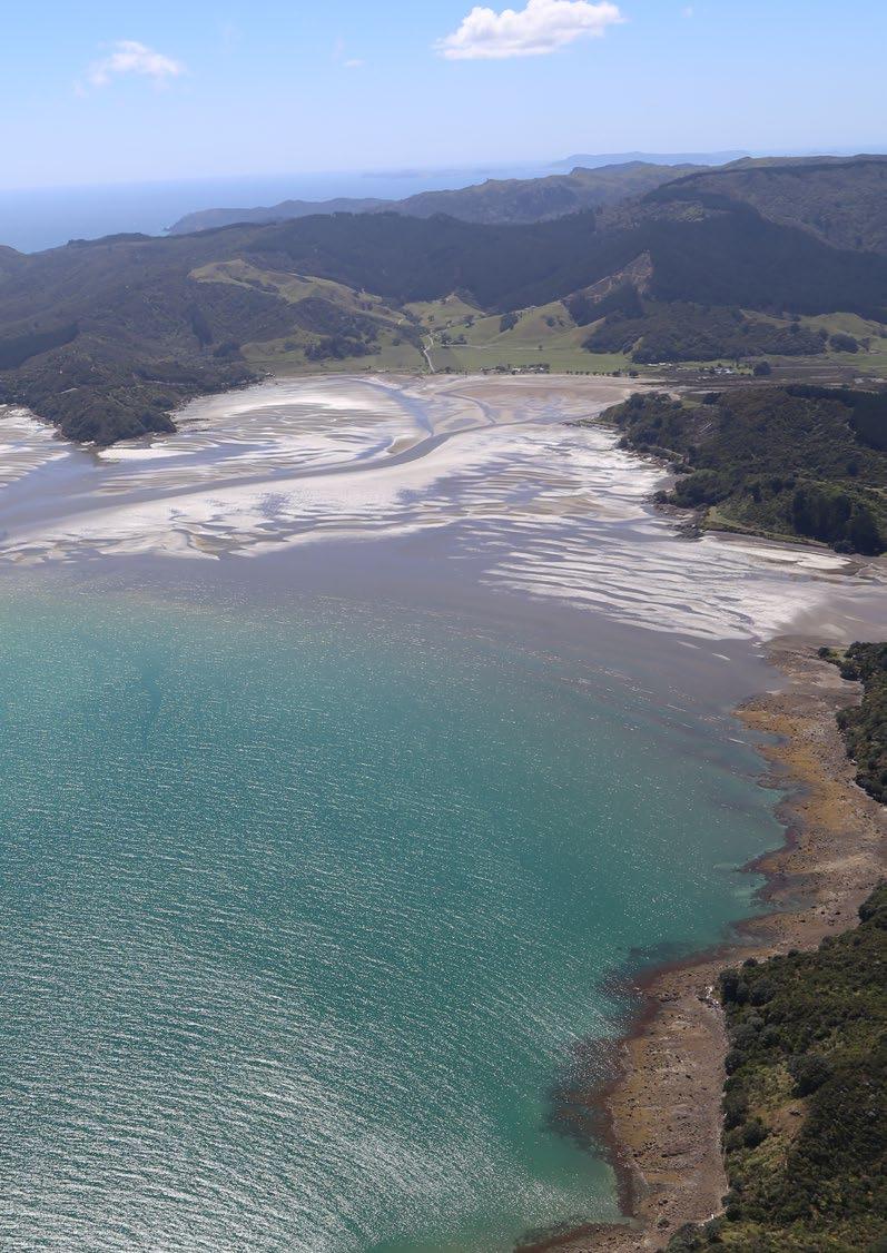
1 95 Miranda SECTION C: WAIKATO S EAST COAST MARINE AND TERRESTRIAL AREAS Miranda Map 7 Legend Extent of Coastal Environment Coastal Terrestrial Area 2: Hauraki Hauraki Coastal Natural Character Ratings: Level 4 High Very High 0 4 km
2 96 Thames Coast COASTAL TERRESTRIAL AREA 3: 0 4 km

3 97 Coastal Characteristics, Coastal Environment Extent and Coastal Context Area This Coastal Terrestrial Area extends from Thames in the south to the southern hills associated with Manaia Harbour in the north, and forms the only area that flanks the eastern coastline of the Firth of Thames. This Coastal Terrestrial Area incorporates the steeply sloping, western-facing foothills associated with the Coromandel Peninsula s rugged interior and includes many small bays and streams. These slopes are typically covered in indigenous shrubland or forest, with rural production land and pine plantations on the easier accessible country. From the Tapu settlement north, the Area has comparatively more rural production land than between Tapu and Thames. The Thames Coast Road extends along the entire length of this Coastal Terrestrial Area, connecting numerous small settlements that pepper this coastal extent. Key coastal characteristics include: relatively straight, narrow stretch of coastline accessed by State Highway 25; deeply incised, forest-clad gullies; numerous small settlements located along the main highway, located on small alluvial plains at river mouths; pockets of cleared land and commercial forestry interspersed along the foreslopes of this coastline, with larger areas of pastoral farming extending eastwards up larger river valleys such as the Waikawau River Valley to the north. The western facing slopes of the rugged Coromandel Range form a highly legible peninsula landform when viewed against the flat cultivated Hauraki Plains to the south. Beyond this coastal environment area the Coromandel Range extends to the east, taking in the Coromandel Forest Park and the many rugged peaks of the Coromandel Peninsula. Below: Forested slopes north of Thames SECTION C: WAIKATO S EAST COAST MARINE AND TERRESTRIAL AREAS

4 98 Abiotic The Thames Coast Coastal Terrestrial Area includes the steep and very steep hill footslopes of the Coromandel Range to the east, rising to 594 metres above sea level at Te Ipuomoehau which forms the backdrop to Ngarimu Bay. The coastline is reasonably straight (as opposed to the more indented coastline of the remainder of the Coromandel Peninsula), however there are local variances where steep sided watercourses have created small alluvial pockets in between the larger protruding foothills. The landform of the Coromandel Ranges remains relatively unmodified. The geology is principally greywacke overlain by volcanic deposits, into which unmodified streams have deeply incised numerous gullies along the entire length of the Area. The Thames Coast Road has created a steeper coastal face where headlands have been truncated to allow road access, but the larger landform of the Peninsula remains intact. There is a Geopreservation Site within the Te Mata Valley and represents a good example of golden orange and red carnelian. The shoreline is typically very narrow comprising predominately rocks with areas of cobbles and grey sand. Streams typically maintain a natural meandering course through the landscape. These watercourses have very steep gradients and are relatively short. The water quality of most streams is likely to be high due to the extensive riparian cover and predominantly forested catchments within the Coromandel Forest Park. Watercourses in the northern half of the Area may have poorer water quality due to depleted riparian vegetation, erosion and inputs from rural and forestry land use, but channel modification is likely to be relatively minor. Below: Matariki Bay and Matariki Islands

5 99 Most of the small coastal settlements are located on debris fans and alluvial fans at the outlet of larger streams. The landform of these fans has been modified to allow urban development and most of the streams are also modified by channelization, diversions and river training structures. Where they exist, beaches are dominated by boulders and gravel, rocky headlands, with isolated areas of mud and sand associated with the alluvial fans at stream outlets. However, along much of the coastline there is no real beach and the steep coastal faces drop directly down to relatively deep water at the interface with the Coastal Marine Area. The area has a windy, strongly maritime climate with warm summers and mild winters. Below: Whakatete Bay SECTION C: WAIKATO S EAST COAST MARINE AND TERRESTRIAL AREAS

6 100 Biotic Land cover analysis: The total land area of the Thames Coast Coastal Terrestrial Area is 6,176ha. This includes 0.5ha of islands. Of this, 44% of the land cover is indigenous forest, 25% is rural production land and 22% is indigenous shrubland. Of the remainder, almost 4% is artificial surfaces, 3% is exotic treeland and very small areas (<1% each) of bare surfaces, exotic scrub, mangroves and waterbodies, in aggregate covering only 1.05%. There is no indigenous wetland cover. The total indigenous land cover is 67%. The entire Coastal Terrestrial Area would originally have been completely covered in indigenous forest. Several shrubland assemblages would have occurred on the alluvial fans and debris fans at stream outlets to the coast. Wetlands would have been naturally uncommon due to the fall towards the coast, although forested riparian wetlands would have been a minor feature of stream floodplains at lower elevations (e.g. Waikawau Stream) and small perched wetlands would have existed on poorly drained gully floors. Around a quarter of this Coastal Terrestrial Area is now in rural production land, most located north of Tapu. Within this northern half of the area indigenous shrubland and coastal forest, much of it without formal legal protection, occupies the coastal cliffs, steep slopes and stream gullies. The indigenous shrubland is a notable but not dominant feature of the northern half, with rural land uses having more prominence. In the southern half of the Area, indigenous shrubland and forest dominates the landscape, with a high proportion having legal protection as Forest Park, reserves or QEII covenant. All of this forest and shrubland can be expected to be modified by past logging, clearance, grazing and weed and pest impacts, but will retain moderate to very high ecological values for its biodiversity and habitat. Watercourses typically have steep short gradients until they reach the alluvial fans, where a flatter gradient and channelizing is more common. Highly modified riparian vegetation is common across most of the rural production land north of Tapu, particularly where the gully systems are more deeply incised. From Tapu south, the riparian forest vegetation is generally intact and extends inland across entire stream catchments. Freshwater fish populations can be expected to be diverse and containing relatively unmodified species assemblages. Native frog populations are also present here. Below: Mudflats associated with the Tararu Stream at Tararu Freshwater macroinvertebrate communities will vary depending on location. From Tapu south, the streams will contain diverse communities of sensitive species, whereas from Tapu north, the macroinvertebrate communities will vary based on dominant land use transitioning to less diverse pollution-tolerant communities where land drainage is more common, riparian vegetation depleted and rural production is more intensive.

7 101 Experiential Boat access is gained from Tararu, Ngarimu Bay, Te Puru, Waiomu, Ruamahunga and Waikawau. Small settlements extend along the immediate coastal edge with the steep coastal ranges extending behind. Pockets of Pohutukawa extends along rocky coastline with sandy beaches often coinciding with small residential settlements. Boat access is also gained from Te Kouma Harbour, Waipapa Bay, Wharf Road (Coromandel), Wyuna Bay, Long Bay and Oamaru Bay. Further north along this area the open grazed farmland extends to meet the coastal edge. Matariki Bay Islands, despite their predominantly grassy landform, retain high perceptions of naturalness due to their limited modification, eroded form and the presence of a few mature pohutukawa trees. State Highway 25 follows the coastal edge closely winding amongst the settlements and intervening pockets of native vegetation cover. Pine plantations are evident on the steeper slopes and are an indication of human modification of the once natural vegetation cover. The extent of modification is balanced with the natural patterns of landform and vegetation. SH25 is a busy highway that services the Coromandel Peninsula and in turn minimising any sense of isolation. Rating at Level 3 Natural Character Attributes Degree of Natural Character Abiotic Biotic Experiential Very High High Moderate to High Moderate SECTION C: WAIKATO S EAST COAST MARINE AND TERRESTRIAL AREAS Moderate to Low Low Very Low Overall Natural Character Rating High Below: The coast road (SH25) predominantly follows the coastline

8 102 Coastal Terrestrial Area 3: Thames Coast Specific Characteristics at Level 4 These are mapped with reference to Map 8 Area Rating Key Values Additional Comments Forested slopes and gullies High Intact indigenous shrubland and coastal forest dominate the southern part of this area, whilst significant areas are noted in the north. Much of this land is protected. Enhances the perceived naturalness due to the lack of modification to these vegetated areas. High experiential values as the area forms a forested eastern backdrop to the Firth of Thames. Excludes modified lands, including pasture and those areas retaining concentrations of housing and structures, notably around Thames. May include the road, power lines and tracks where the indigenous vegetation extends to the coastline. The vegetation forms part of the western extent of the broader inland Coromandel Forest Park and the many rugged terrain of central Coromandel Peninusla. Matariki Bay Islands High High experiential values due to separation from mainland, distinctive eroded rock outcrops with limited modification. No abiotic modifications Includes areas of pasture on islands. Forested Slopes and gullies close to Ruamahunga


9 103 Matariki Islands Matariki Islands SECTION C: WAIKATO S EAST COAST MARINE AND TERRESTRIAL AREAS Forested Slopes and Gullies Map 8 Legend Extent of Coastal Environment Coastal Terrestrial Area 3: Thames Coast Thames Coast Coastal Natural Character Ratings: Level 4 High Very High 0 3 km
10 104 Coromandel Harbour COASTAL TERRESTRIAL AREA 4: km

11 105 Coastal Characteristics, Coastal Environment Extent and Coastal Context Area This Coastal Terrestrial Area is located on the western side of the Coromandel Peninsula and encompasses the lower elevation foothills of the Coromandel Ranges surrounding Manaia Harbour, Coromandel Harbour and the bays to the north. The area comprises three main landforms. The steep to rolling coastal peninsulas jutting out into the harbour and islands have variable cover of either indigenous shrubland or rural production land and access is relatively limited. The eastern extent of the Area abutting the Coastal Context Area consists of steep to rolling Coromandel Range foothills that slope down towards the coast and end at, or close to, the coastal margin. These foothills are covered in indigenous shrubland, indigenous forest or plantation forests on steeper slopes and gullies and isolated pockets of rural production land on the easier country. Between the foothills and the coast, the relatively narrow rolling to flat coastal plains around Coromandel Harbour are dominated by rural production land, lifestyle properties and coastal wetlands/saltmarsh. Key coastal characteristics include: the steep narrow peninsulas and large islands creating the enclosed harbour environments, the prominent headlands (north of Manaia harbour, Koputauaki east of Oamaru Bay and east of Ngohitanu Bay) covered in indigenous shrubland, the smaller islands covered in indigenous shrubland and the extensive mudflats, saltmarsh and estuary margin areas. Beyond this Coastal Terrestrial Area, the Coastal Context land rises into the Coromandel Ranges. This elevated and steep land is predominantly covered in indigenous shrubland and forest within the Forest Park and is managed by the Department of Conservation. Large areas east of Te Kouma and northeast of Kikowhakarere Bay are in plantation forestry and the harvesting rotation is visible from the coast. Below: Little Passage and northern part of Whanganui Island SECTION C: WAIKATO S EAST COAST MARINE AND TERRESTRIAL AREAS

12 106 Abiotic The overall landform of the Coromandel Ranges remains relatively unmodified and the lower elevation peninsulas, islands and foothills retain natural topography. The terrain is dominated by the underlying volcanic rock, but the lower elevation means streams gullies are not so deeply incised as occurs to the south. Coastal erosion processes have carved headlands and created beaches and bays. On the plains, there is a moderate level of modification of the flatter land for settlement and rural productive land. In a few places the coast road has created a steeper coastal face where headlands have been truncated to allow road access, but other roads typically follow the landform. The coastline is severely indented, where long, narrow peninsulas extend seaward, with many islets/ rocks also evident. Large alluvial deposits are concentrated around the mouths of local rivers and are often the most settled areas (the town of Coromandel for instance). The topography is steep to very steep in places and rises to 394 metres above sea level at the Pukewhakataratara rock pillars, which straddle the boundary between the Coastal Terrestrial Area to the south. This prominent hilltop is also a Geopreservation Site. Composed of old lahar deposits this landform represents one of the best examples of rock pillars in the Coromandel Peninsula. Streams typically maintain a natural meandering course through the landscape. These watercourses have moderate gradients and are relatively short, though the streams exiting over the Plains will have flatter gradients at their outlets. The water quality of streams is likely to be quite variable, reflecting the dominant land use of the catchment. Small streams with catchments located entirely in indigenous shrubland are likely to have very good water quality, diverse fish and macroinvertebrate fauna. Streams with a large proportion of their catchment in rural productive land or plantation forestry are likely to have moderate or poor water quality due to depleted riparian vegetation, erosion and inputs from rural and forestry land use, with moderate diversity of fish and macroinvertebrate fauna. Channel modification occurs where river training works and channelization has been undertaken to enable settlements and productive land development. Below: Papakarahi Bay Beaches are limited to small bays between rocky headlands, sometimes with sand, but typically with gravel and boulders and rocky outcrops. Where the larger streams discharge onto a coastline with a flatter gradient, there are large areas of mudflats featuring saltmarsh vegetation. However, along much of the coastline, there is no real beach and the steep coastal faces drop directly down to relatively deep water at the interface with the Coastal Marine Area. The area has a windy, strongly maritime climate with warm summers and mild winters.

13 107 Biotic Land cover analysis: The total land area of the Coromandel Harbour Coastal Terrestrial Area is 6,667ha. This includes 510ha of islands. Of this, 36% of the land cover is indigenous shrubland, 34% is rural production land, 12% is exotic treeland and 11% is indigenous forest. Of the remainder, 3% is artificial surfaces, with very small areas (<1% each) of bare surfaces, exotic scrub, mangroves, indigenous wetland and water bodies, in aggregate covering only 1%. The total indigenous land cover is 48%. The entire Coastal Terrestrial Area would originally have been completely covered in indigenous forest. Several shrubland assemblages would have occurred on the steeper faces following slips and in association with natural river erosion processes. Wetlands would have been naturally uncommon due to the fall towards the coast, although forested gully floor wetlands would have been a feature of streams at lower elevations with poorly drained sediments. Around half this Coastal Terrestrial Area is in rural production land and plantation forestry and half is in indigenous shrubland and forest, with very small areas associated with stream gully systems. This is also true of the islands included in the Area, with some being managed as rural production land for livestock grazing and others regenerating in indigenous shrubland. The Coromandel Ranges are a more distant backdrop in this Area than along the Thames Coast. Despite the relatively high proportion of indigenous vegetation cover, only small areas have formal protection in reserves or QEII covenants. Watercourses tend to have steep short gradients, except across short areas of the plains where a flatter gradient occurs. Riparian vegetation remains across more than half of the stream reaches, with more substantial riparian vegetation associated with the larger patches of indigenous vegetation. Freshwater fish populations can be expected to be relatively diverse. The streams on the Plains will provide a conduit for migratory species to move to and from the sea and to allow species that prefer cool mountain streams with good water quality to move upstream to the Coromandel Ranges. Freshwater macroinvertebrate communities will vary depending on location, with diverse communities of sensitive species occurring where riparian vegetation is more extensive, transitioning to less diverse pollution-tolerant communities where riparian vegetation is depleted and rural production is more intensive. SECTION C: WAIKATO S EAST COAST MARINE AND TERRESTRIAL AREAS Below: Motutapere Island

14 108 Experiential State Highway 25 follows the coastal edge, closely winding amongst the settlements before heading steeply inland toward Manaia. The extent of modification is balanced with the natural patterns of landform and vegetation, but is evident throughout the area. SH25 is a busy highway that services the Coromandel Peninsula and in turn minimising any sense of isolation. Pockets of native vegetation cover extend along the coastal edge and within valleys, providing a sense of what the unmodified landscape may have once been. Small areas of native vegetation extend along the valleys and coastal edge highlighting the natural landform. Interspersed is the agricultural farmland that covers much of this unit. Between Manaia and Te Kouma Harbour the State Highway extends through native bush cover. The remainder of the coastal unit is largely modified with forestry and agricultural land use, with similar native bush cover at the northern end of the area, by Koputauaki Bay. Coastal settlements and associated roading dominate Coromandel harbour s coastline with pockets of native vegetation. The backdrop to Coromandel township includes a mix of native bush vegetation and forestry blocks. The islands surrounding Coromandel harbour are largely modified with those less modified islands extending north of Waimate Island. The largest island, Whanganui Island, supports grazing farmland and housing with tracks throughout the island. The harbour and beaches are occupied regularly for recreational activities by locals and visitors to the area. Below: Wharf at Te Kouma Either side of Coromandel township settlement extends in pockets of rural residential housing and residential subdivision. Ruffin peninsula is heavily inhabited and modified along its shoreline with boat access points.

15 109 Rating at Level 3 Degree of Natural Natural Character Attributes Character Abiotic Biotic Experiential Very High High Moderate to High Moderate Moderate to Low Low Very Low Overall Natural Moderate to High Character Rating Below: Preece Point SECTION C: WAIKATO S EAST COAST MARINE AND TERRESTRIAL AREAS
16 110 Coastal Terrestrial Area 4: Coromandel Harbour Specific Characteristics at Level 4 These are mapped with reference to Map 9 Area Rating Key Values Additional Comments Motuoruhi Island Group Very High Unmodified island group. Intact indigenous forest and manuka/ kanuka shrublands cover these islands. High levels of perceived naturalness Total of four islands: Motuoruhi Island (Goat Island); Motuokino Island (Shag Rock); Motukaramea Island (Kaikai Island) and Motumorirau Island (Pauls Island). Also includes Hautapu Rocks. Motutapere and Matukakarikitahi Islands Very High Protected Islands. Steep faces feature intact native forest and rock shores. Abiotically, unmodified. High experiential values with no perceived modification on either island. Total of two islands: Motutapere Island and Matukakarikitahi Island (Rat Island). Excludes marine farms off Rat Island. Cow and Calf Islands Very High Unmodified islands containing very high abiotic, biotic and experiential levels of naturalness due to their rocky exposed character and the intact vegetation on the larger Cow Island. Total of two islands: Cow Island and Calf Island. Koputauaki High Indigenous kanuka manuka shrubland dominates much of the lower slopes terminating at the water s edge. Upper eastern slopes are largely indigenous forest in DOC ownership. High experiential naturalness. Excludes highly modified coastal flats at Koputauaki Bay and exotic forest. Includes part of road, power lines and occasional house. Connected to broader inland indigenous forest associated with the central peninsula Vegetated southern slopes High Prominent dome shaped headland, the majority of which is manuka kanuka. Scattered exotic wilding pines also present. Forested backdrop to Manaia Harbour amplifies perceived levels of naturalness to bay Excludes areas of forestry and pastoral land. Includes part of SH25. Forms part of broader inland indigenous forest associated with central peninsula. Wekarua and Tataweka Islands High Regenerating indigenous scrub with no abiotic modification. High levels of perceived naturalness Total two islands: Wekarua and Tataweka Islands. Aqauculture is present off shore. Refer to Coastal Marine Area B. Coromandel Vegetated Slopes High Indigenous vegetated lower slopes of forest clad hills east of Coromandel settlement. Forested backdrop amplifies perceived naturalness Excludes modified pastoral land and house at lower elevations. Forms part of broader inland indigenous forest associated with central peninsula.


17 111 Koputauaki Motuoruhi Island Group Motutapere and Motukakarikitahi Islands Cow and Calf Islands Cow and Calf Islands Coromandel Vegetated Slopes SECTION C: WAIKATO S EAST COAST MARINE AND TERRESTRIAL AREAS Wekarua and Tataweka Islands Vegetated Southern Slopes Legend Extent of Coastal Environment Coastal Terrestrial Area 4: Coromandel Harbour Coromandel Harbour Coastal Natural Character Ratings: Level 4 High Very High Map km
18 112 Colville COASTAL TERRESTRIAL AREA 5: 0 2 km

19 113 Coastal Characteristics, Coastal Environment Extent and Coastal Context Area The Colville Coastal Terrestrial Area is a slightly concave, curved section of gently sloping to steep coastline at the north-western edge of the Coromandel Peninsula, extending northwards from the northern extent of the Coromandel Harbour in the south, to the southern base of the steep Moehau Range in the north. This Coastal Terrestrial Area also includes the Motukawao Group, a group of rugged volcanic islands located some two to seven kilometres offshore. Key coastal characteristics include: narrow, relatively concave stretch of coastline, small sloping highly modified coastal margin and valleys, includes a portion of the steep forested fore slopes of the Coromandel Range; in places manuka and kanuka extends from ridge tops to the coast; islands associated with the rugged Motukawao Group; rocky coastline of Amodeo Bay; the enclosed Colville Bay. Eastwards of the coastal environment, the coastal context includes the Colville Road, which extends inland from Amodeo Bay to connect with the head of the Colville Valley. Further east the mountainous interior of Coromandel Range extends to the eastern coast at Coromandel Peninsula. This elevated and steep land is predominantly covered in indigenous shrubland and forest within the conservation land and is managed by the Department of Conservation, though not all appears to have formal protection. Above: Turipeka Point SECTION C: WAIKATO S EAST COAST MARINE AND TERRESTRIAL AREAS

20 114 Above: Otautu Bay Abiotic The Colville Coastal Terrestrial Area includes the steep and moderately steep foothills of the higher range to the west, rising to 511 metres above sea level, above Ngohitanu Bay. Similar to other Coastal Terrestrial Area s, the geology of this Coastal Terrestrial Area is principally greywacke, overlain by prolific volcanic material. The coastline is reasonably straight, with Colville Bay being the principal inlet of this Coastal Terrestrial Area. This Coastal Terrestrial Area also includes the cluster of conspicuous and prominent volcanic island landforms. A Geopreservation Site of Waitete Bay Oligocene sediments represents the best exposure of the Te Kuiti Group sequence on the Coromandel Peninsula. River valleys extend inland behind the volcanic headlands to a longer distance on the western coast of the peninsula. The principal river is the Umangawha Stream which flows in a northerly direction to Colville Bay. At its mouth are extensive alluvial deposits, much of which have been converted to farmland and is the location for the small settlement of Colville. Wetlands would have been originally associated with these poorly drained river valleys. Other watercourses tend to be short and steep and drain directly into the sea. The coast in this area is characterised by a rocky coastal interface and in places rock platforms with a rapid decent in depth. Flatter gradient beaches associated with coastal plains are muddy with little sand.

21 115 Biotic Land cover analysis: The total land area of the Colville Coastal Terrestrial Area is 4,517ha. This includes 79ha of islands. Of this, 38% of the land cover is indigenous shrubland, 34% is rural production land, 16% is indigenous forest and 10% is exotic treeland. Of the remainder, there are very small areas (<1% each) of artificial surfaces, bare surfaces, exotic scrub, mangroves, indigenous wetlands and waterbodies, in aggregate covering only 1.4%. The total indigenous land cover is 55%. The entire area would have once been completely covered in Indigenous forest with shrubland occurring on steeper faces where erosion would have occurred. Indigenous shrubland now covers steeper land and in gully headwaters with the remaining land forming rural production land of either pasture or exotic pine forestry. The catchment is steep and water courses have created deeply incised gullies that support fingers of native shrubland species with Colville s southern peninsula support regenerating native shrubland. Valley floors support productive pasture with modified drainage patterns supporting minimal indigenous vegetation. The streams on the Plains will provide a conduit for migratory species to move to and from the sea and to allow species that prefer cool mountain streams with good water quality to move upstream to the Coromandel Ranges. The estuarine reaches of Colville Bay and Waiaro have drained wetlands with some remnants of saltmarsh near Colville. There continues to be a small amount of saltmarsh with good sequences that transition through to shrubland at higher elevations. Motukaramarama Island is one of the Motukawao Islands group. It lies some 3.5 km off the coast and is uninhabited. It provides a nesting site for about 3500 pairs of Australasian Gannets along with its neighbouring islands in the cluster. Some of the indigenous shrubland in the ranges is protected in Conservation area and by QEII Covenants. Above: Motukaramarama Island (Bush Island), part of the Motukawao Island Group SECTION C: WAIKATO S EAST COAST MARINE AND TERRESTRIAL AREAS
22 116

23 117 Experiential Boat access is gained from Papaaroha, Amodeo Bay, Waitete Bay and Otautu Bay. Settlements are sited around these areas and are largely devoid of native vegetation cover. Fingers of native vegetation cover extend up the valleys behind the settlements and along the Colville Peninsula. A large portion of the coastal land is rolling and steep farmland, with steeper slopes still containing within native bush vegetation. The estuaries of Colville Bay and Waiaro are remote and largely unoccupied along the margins. Beyond Colville access is more remote along the coastline with less occupation and visitors, creating a strong sense of isolation. This Coastal Terrestrial Area includes the Motukawao Island Group, a remote and intact group of rugged and exposed islands. These islands are uninhabited and retain very high levels of perceived naturalness through their wild and rugged nature. Rating at Level 3 Natural Character Attributes Degree of Natural Character Abiotic Biotic Experiential Very High High Moderate to High Moderate Moderate to Low Low Very Low Overall Natural ModerateHigh Character Rating Left: Colville Bay Below: Motumakareta Island, north of Elephant Cove, Motukawao Island Group SECTION C: WAIKATO S EAST COAST MARINE AND TERRESTRIAL AREAS
24 118 Coastal Terrestrial Area 5: Colville Harbour Specific Characteristics at Level 4 These are mapped with reference to Map 10 Area Rating Key Values Additional Comments Paeroa Slopes Very High These elevated and steep upper slopes are covered in indigenous forest and shrubland. Upper eastern parts of the area is within conservation land. Excludes pastoral land Forms southern part of indigenous-clad Moehau Range No modification evident. Motukawao Island Group Very High Conspicuous, prominent and unmodified volcanic island group. Very high levels of perceived naturalness due to their intact vegetation and rocky, exposed character. The islands are home to many threatened bird species Aquaculture located off Moturua Island (Rabbit Island) - Refer to Coastal Marine Area B Collectively, naturalness is amplified due to the lack of modification Colville Bay slopes High Modified Manuka kanuka dominated headland. High abiotic, biotic and experiential degrees of naturalness Scattered with dwellings and associated clearings of exotic grassland. Contained by pastureland. Excludes forestry. Papaaroha High Indigenous kanuka manuka shrubland dominates much of the lower. Upper ridges are largely indigenous forest in DOC ownership. Does not include extensively modified lower slopes and valley floor. Forms part of broader indigenous vegetation cover of central peninsula.
25 119 Paeroa Slopes Colville Bay Slopes SECTION C: WAIKATO S EAST COAST MARINE AND TERRESTRIAL AREAS Motukawao Island Group Papaaroha Legend Extent of Coastal Environment Coastal Terrestrial Area 5: Colville Colville Coastal Natural Character Ratings: Level 4 High Very High Map km
26 120 Port Jackson COASTAL TERRESTRIAL AREA 6: 0 3 km

27 121 Coastal Characteristics, Coastal Environment Extent and Coastal Context Area The Port Jackson Coastal Terrestrial Area encircles the narrow rugged peaks of the Moehau Range which makes up the northern tip of the Coromandel Peninsula, extending northwards into the Hauraki Gulf. Immediately north of Waiaro the coastal terrestrial area extends in a clockwise direction around the tip of the Peninsula. The area encompasses the coastal tips of the long ridges and steep, narrow valleys radiating outwards from the Moehau Range, ending at Te Karaka Bay on the east coast of the Coromandel Peninsula. The landform is very intact. Key coastal characteristics include: the Port Jackson Road extends at the foot of gently sloping ridgelines; lower slopes of the range are largely cleared of vegetation, in areas native forest extends from the upper reaches of the range down gullies and in places meets the coastline; many ridges and hillsides are steep with slipping and some erosion evident; two settlements, the sandy embayment of Port Jackson at the tip of the Peninsula and the larger harbour of Port Charles to the south; scattered small islands, including Square Top Island in the north and Motukokopu Island, a small sea stack off the coast of the eastern headland of Port Charles. Inland of this Coastal Terrestrial Area, the coastal context includes the Moehau Range which climbs to 1,341 metres above sea level. Colville Channel extends northwards of the Port Jackson Coastal Terrestrial Area, between Coromandel Peninsula and Great Barrier Island. South eastward of this Coastal Terrestrial Area are several island archipelagos including the Cuvier, Mercury and Ohinau Islands. Below: The agricultural lower slopes of the Moehau Range, just south of Port Jackson SECTION C: WAIKATO S EAST COAST MARINE AND TERRESTRIAL AREAS

28 122 Abiotic Above: Stony Bay The Port Jackson Coastal Terrestrial Area includes the steep and very steep foothills of the Moehau Range, rising to 653 metres above sea level on the western coastline. This Coastal Terrestrial Area represents the northerly tip of the peninsula and includes a complex sequence of dramatic exposed cliffs, headlands, indented bays and inlets. Beaches are predominantly white sand although gravelly/ stony beaches are also common. The geology is principally greywacke overlain by prolific volcanic deposits. Geopreservation Sites in this Coastal Terrestrial Area include a concentration on the western side of the peninsula around Fantail Bay and include the Fantail Bay, Paritu hornfels, which represent the best and most easily accessible example of the Paritu Pluton and contacts with greywacke, which has metamorphosed to hornfels. Other sites here include the Paritu granite quarry areas and the Darkie Stream tourmaline. At Ka-iti Point, west of Port Jackson is the Ka-iti porphyrite, a well exposed coastal section of this hydrothermally altered intrusion. Further east is the Fletchers Bay Waitemata Group sediments and the Sugar Loaf volcanic sequence, a series of spectacular stone pinnacles. Landforms are relatively unmodified apart from small areas on valley floors, especially at Port Charles. There are extensive steep rocky coastal faces as well as flatter gradient beaches. Like other areas on the peninsula, watercourses here are often short and steep with the longer watercourses associated more on the easterly side of this Coastal Terrestrial Area, draining into the deeper bays, including Stony Bay and Port Charles and including Stony Bay Creek, Okahutahu Stream and Tangiaro Stream. Wetlands would have originally been associated with these poorly drained river valleys. The area receives strong winds due to its isolated location.

29 123 Biotic Land cover analysis: The total land area of the Port Jackson Coastal Terrestrial Area is 8,429ha. This includes 5.6ha of islands. Of this, 37% of the land cover is indigenous shrubland, 32% is rural production land and 28% is indigenous forest. Of the remainder, 1% is exotic treeland and there are very small areas (<1% each) of artificial surfaces, bare surfaces, exotic scrub, mangroves and indigenous wetlands, in aggregate covering only 1.4%. There are no waterbodies. The total indigenous land cover is 65%. The entire area would have once been completely covered in Indigenous forest with shrubland occurring on steeper faces where erosion would have occurred. Indigenous shrubland now covers steeper land and in gully headwaters with the remaining land dominated by indigenous shrubland and forest. This unit covers the top of the Coromandel Peninsula with a mountain range extending steeply to the coastal edge. Coromandel Forest Park extends over this range with much of the indigenous land cover contained within this Conservation Area and other QEII Covenants. The lower foothills continue with deeply incised gullies that support fingers of native shrubland species and productive pasture which is clustered around Port Jackson, Fletcher Bay and Port Charles. Valley floors support productive pasture with modified drainage patterns supporting minimal indigenous vegetation. The streams on the plains will provide a conduit for migratory species to move to and from the sea and to allow species that prefer cool mountain streams with good water quality to move upstream to the Coromandel Ranges. Wetlands are naturally uncommon in this area except poorly draining gully systems on flatter land, mainly around Fletcher Bay, Sandy Bay and Port Charles. And the coastal areas from Cape Colville to Sandy Bay support rare and threatened wading and coastal bird species. The native Pateke, or Brown Teal, is an endangered duck species found in the Port Charles and Waikawau area along with endangered invertebrate Moehau Stag Beetle. Left: Moehau Stag Beetle SECTION C: WAIKATO S EAST COAST MARINE AND TERRESTRIAL AREAS

30 124 Experiential The most remote areas of the Coromandel Peninsula, Port Jackson, Fletcher Bay and Port Charles providing small settlement areas with boat access. The steep terrain supports grazing farmland with more frequent pockets of native bush cover that extend down from the central range. Steep coastal edges and isolated embayments have limited access with some areas completely inaccessible by road. Sugar Loaf and Square Top Island (including The Pinnacles) are remote areas exemplifying high levels of perceived naturalness. Numerous walks within this Coastal Terrestrial Area enable people to experience remote-like characteristics, notably on Muriwai Walk, Coromandel Walkway and Stony Bay Track. From Fletcher Bay to Port Charles and also south of Port Charles, the coastal environment is dominated with native bush cover, with some narrow road access from Port Charles to Stony Bay. The natural environment dominates with limited modification increasing the perception of naturalness in this area. Below: Forested slopes above Shag Bay

31 125 Rating at Level 3 Degree of Natural Natural Character Attributes Character Abiotic Biotic Experiential Very High High Moderate to High Moderate Moderate to Low Low Very Low Overall Natural Moderate to High Character Rating Below: Kaiiti Point, Port Jackson SECTION C: WAIKATO S EAST COAST MARINE AND TERRESTRIAL AREAS
32 126 Coastal Terrestrial Area 6: Port Jackson Specific Characteristics at Level 4 These are mapped with reference to Map 11 Area Rating Key Values Additional Comments Moehau Vegetated Slopes Very High An intact sequence of native forest extends down the short, steep ridgelines from the top of the Moehau Range to the waters edge in this area. Unmodified abiotic and biotic tract of land. Very high experiential naturalness Includes parts of the Fantail Bay Recreation Reserve and Coromandel Forest Park. Part of Moehau Range. Provides critical vegetation link to coast at Fantail Bay. Upper slopes are part of DOC recreation reserves. Excludes pastoral farmland and modified lower slopes. Stony Bay Forest Very High Steep valleys and spurs contain a mixture of unmodified native shrub land and forest. Extensive areas under formal protection in Conservation Areas, QEII covenants. The Moehau ecological area in particular, supports an almost complete altitudinal sequence of plant and animal communities from near sea level to sub-alpine conditions. It is home to a number of rare or endangered endemic species (e.g. land snails, Archey s frog). An exceptional tract of naturalness. Entirety of the area under DOC management. Include QEII land to south. Includes power line, Stony Bay Track, Road, walkway and Coromandel Walkway. Excludes the modified lower slopes fringing Stoney Bay Beach. All these are subservient to the extent of forest. Forms part of inland Moehau Range. Puroa and Onekura slopes Very High Unmodified indigenous bush and shrubland extends from the first ridgeline to the coast. Highly natural and relatively inaccessible. Very High perceived level of naturalness due to the rugged and exposed character of the coastal ridgelines and remote inner valleys. Manuka kanuka dominates. Scattered wilding pines, native forest on ridge tops at the north and south of the area. Regenerating areas of bush. Does not include the modified lower slopes to the north and east. Excludes the small modified coastal fringe of Potiki Bay. Forms part of inland Moehau Range. Sugar Loaf and Square Top Island Very High Exposed island and headland, extenuating experiential characteristics including remoteness Dramatic eroding cliffs and rocky foreshore with indigenous scrub. Sugar Loaf part of Stony Bay Recreation Reserve.
33 127 Moehau Vegetated Slopes Sugar Loaf and Square Top Island Stony Bay Forest Puroa and Onekura Slopes SECTION C: WAIKATO S EAST COAST MARINE AND TERRESTRIAL AREAS Map 11 Legend Extent of Coastal Environment Coastal Terrestrial Area 6: Port Jackson Port Jackson Coastal Natural Character Ratings: Level 4 High Very High 0 2 km

34 128 Kennedy Bay COASTAL TERRESTRIAL AREA 7: km

35 129 Coastal Characteristics, Coastal Environment Extent and Coastal Context Area Located on the eastern coast of the Coromandel Coastline, this Coastal Terrestrial Area extends from Waikawau Bay in the north to the coastal peak of Pukenui, immediately south of Kennedy Bay in the south. The area includes the forest clad slopes of the southern parts of the Moehau Range and northern parts of the Coromandel Range and includes the embayments of Waikawau Bay and Kennedy Bay. This undulating, predominantly modified Coastal Terrestrial Area contains a number of small settlements and road access to the majority of the coastline, although it is very intact as a landform. Coastal characteristics include the uninterrupted slopes extending from the coastline up to the ridgelines and peaks; the enclosed bays at Waikawau and Kennedy Bay; the extensive tracts of very steep rocky shoreline with continuous indigenous shrubland/forest up to ridgeline; the barrier dune at Kennedy Bay and relic dune ridges behind; steep coastal faces dropping down to the ocean; the rear dune saltmarsh and wetlands at Waikawau and Kennedy Bay and the prominent headlands on either side of Kennedy Bay and Waikawau. Beyond the coastal environment, the coastal context comprises elevated and forest clad peaks and ridges associated with the Coromandel Forest Park. Above: Development within the bush at Tuateawa SECTION C: WAIKATO S EAST COAST MARINE AND TERRESTRIAL AREAS

36 130 Below: Waikawau River draining into Waikawau Bay. The Waikawau dunes are evident at the bottom of the photograph Abiotic The Kennedy Bay Coastal Terrestrial Area includes the steep and very steep foothills and escarpments of the westerly located inland hills, rising to 364 metres above sea level at Hapapawera, as well as including the broad sandy, predominantly flat embayments of Waikawau Bay and Kennedy Bay. The heads of the bays are an accumulation of alluvial deposits comprising mud, sand, dunes and gravels and typical of other Coastal Terrestrial Areas, is the main focus of settlement. Coastal cliffs and weathered bluffs characterise the coastline north of Kennedy Bay. This Coastal Terrestrial Area also includes the series of small, yet prominent offshore volcanic island platforms. There is one Geopreservation Site within this Coastal Terrestrial Area and it is located at Kennedy Bay, known as the Tumbledown Rocks rock fall. Landforms are largely unmodified except on valley floors at Waikawau and Port Kennedy and rural residential development at Tuateawa. There are extensive steep rocky coastal faces and rocky headlands with small, sometimes sandy, mainly rocky bays in between. Watercourses are short and steep along the headlands, due to their small catchments. However they tend to be longer where they drain into the embayments, due to the catchments being broader. Some longer watercourses include Harataunga Stream and Kopurukaitai Stream which drain into Kennedy Bay and the Waikawau River which flows into Waikawau Bay. Extensive wetlands would originally have existed in the poorly drained flat-gradient river valleys, with extensive rear dune and river valley wetlands located behind the barrier dune ridge at Port Kennedy and Waikawau Bay, many now drained. Biotic Land cover analysis: The total land area of the Kennedy Bay Coastal Terrestrial Area is 4,070ha. This includes 0.6ha of islands. Of this, 61% of the land cover is indigenous shrubland, 20% is indigenous forest and 13% is rural production land. Of the remainder, almost 4% is exotic treeland, 1% is indigenous wetlands and there are very small areas (<1% each) of artificial surfaces, bare surfaces, mangroves and waterbodies, in aggregate covering only 1.5%. There is no exotic scrub. The total indigenous land cover is 82%.
37 131 Coromandel Forest Park dominates the area with some of it extending from the ranges to the coast at Waikawau Bay. The vegetation patterns continue to follow the landform with steep and deeply incised valleys supporting indigenous shrubland and forest. Waikawau Bay wetland supports a number of rare and endangered wading birds, including the Pateke and invertebrate populations. Watercourses tend to have steep short gradients, except across short areas of the plains at Waikawau and Kennedy Bays where a flatter gradient occurs. Riparian vegetation remains across most of the stream reaches with freshwater fish populations that are expected to be relatively diverse. Freshwater macroinvertebrate communities will vary depending on location, with diverse communities of sensitive species occurring where riparian vegetation is more extensive, transitioning to less diverse pollution-tolerant communities where riparian vegetation depleted and rural production is more intensive. Coastal wetland and saltmarsh is found at Kennedy Bay with vegetation sequence extending to the indigenous shrubland around the coastal edges. The productive rural land is limited to river valleys at Kennedy and Waikawau Bays with small pockets of open pasture found along coastal edge of Tuateawa. Experiential Boat access is gained from Tuateawa, Little Bay and Kennedy Bay. Access is gained from both the east and west coast roads to these areas. Waikawau Bay is less populated than its neighbouring Little Bay, which includes residential subdivision and rural residential subdivision. The wide unmodified dune system along Waikawau Bay provides a strong visual indicator of the natural processes and patterns. Grazing farmland extends immediately behind and along the valley and lower slopes of the area. Further south and into the ranges behind, natural regenerating bush is interspersed with blocks of forestry plantations. Between Little Bay and Tuateawa the coastline is relatively unmodified and the native bush cover dominates. Access through this area is gained only via the coastal road and Taiharuru Bay is remote with either side completely covered in native bush. Modification to this area is limited and visually unapparent. Further south at Tuateawa and Kennedy Bay human modification is visually apparent. Whilst native vegetation cover dominates at Tuateawa the cover is less cohesive and the visual indicators of human modification are apparent. This is with the exception of Tokangawha Point which is covered in regenerating coastal native bush cover and includes the historic features of a shipyard and whaling station. SECTION C: WAIKATO S EAST COAST MARINE AND TERRESTRIAL AREAS From Motukuku Point to Anarake Point the coastline returns to its more highly natural state with no visually apparent modification and is dominated by native bush cover. Rating at Level 3 Degree of Natural Character Natural Character Attributes Abiotic Biotic Experiential Very High High Moderate to High Moderate Moderate to Low Low Very Low Overall Natural Character Rating High

38 132 Coastal Terrestrial Area 7: Kennedy Bay Specific Characteristics at Level 4 These are mapped with reference to Map 12 Area Rating Key Values Additional Comments Waikawau Bay Dune and Estuary High Extensive dune system, small patches of indigenous vegetation including pingao and spinifex. Abiotically, unmodified. Experiential naturalness amplified due to lack of structures and modification. Part of Waikawau Bay farm park and recreation area managed by DOC. Excludes pastureland and Waikawau Beach Road. Kokumata and Whanake Very High Unmodified indigenous forest covers this headland. Cliffed head, rocky shore platforms, offshore rock stacks, alongside native vegetation contributes to a remote and untouched character. Includes track, part of Tuateawa Road and small buildings in Taiharuru Bay. Excludes housing at Tuateawa. Part of central spine of indigenous vegetation cover. Critical vegetation sequence from mountains to sea. Kahutara High Steep, craggy and unmodified weathered coastal cliffs and bluffs. Includes tracks, part of Tuateawa Road and occasional isolated small buildings. Large intact area of broadleaved indigenous hardwoods. Provides northern vegetated backdrop to Kennedy Bay. Kennedy Bay Slopes High (southern tip), Very High (remainder) Precipitous, exposed sea cliffs, small sandy embayment s and rock platforms. Area of native shrubland with pockets of native forest. Evidence of wilding pine, reduces levels of naturalness. Part of central spine of indigenous vegetation cover. Critical vegetation sequence from mountains to sea. Provides southern vegetated backdrop to Kennedy Bay. Coastline north of Kennedy Bay


39 133 Waikawau Bay Dunes and Estuary Kokumata and Whanake Waikawau Bay Dunes and Estuary 0 2 km SECTION C: WAIKATO S EAST COAST MARINE AND TERRESTRIAL AREAS Kahutara Kennedy Bay Slopes Map 12 Legend Extent of Coastal Environment Coastal Terrestrial Area 7: Kennedy Bay Kennedy Bay Coastal Natural Character Ratings: Level 4 High Very High
40 134 Whangapoua COASTAL TERRESTRIAL AREA 8: km

41 135 Coastal Characteristics, Coastal Environment Extent and Coastal Context Area This Coastal Terrestrial Area is central to the Whangapoua Harbour and includes the highly modified alluvial valley floor, the Omara sand spit and settlement of Matarangi Beach. Key coastal characteristics include; developed settlements of Whangapoua and Matarangi, which are situated on a barrier beach separating the shallow harbour from the ocean; gently sloping ridges, highly modified cleared valley floors and coastal margins; largely vegetated hill country, the majority of which is exotic forestry and or manuka/kanuka with small patches of native forest; Whangapoua Harbour is a large estuarine environment featuring remnant terrestrial plant communities on its fringe; small ephemeral streams drain the valleys and coastal margins surrounding the Harbour; the Opitonui River, the Owera Stream and other smaller watercourses drain into the Harbour from the south; features the undeveloped and relatively inaccessible Wainuiototo Bay or New Chums Beach, the beach is famous for its untouched character and features a white sand beach backed by native bush and coastal hill country. Beyond the coastal environment, the coastal context contains the foreslopes of the Coromandel Range and encircle Whangapoua Harbour and its small plains. Largely cloaked in native forest and forestry plantations, the foothills extend westwards to meet the Coromandel Ranges. Abiotic The Whangapoua Coastal Terrestrial Area is centred on the Whangapoua Harbour and associated watercourses draining the land. The topography is predominantly low lying and flat, with small foothills rising to 273 metres above sea level at Kakahoroa. Alluvial soils predominate the lowlands, especially around the harbour, while sand and silt accumulations form the most populated part of this Coastal Terrestrial Area at Matarangi. There are two Geopreservation Sites: Whangapoua columnar jointed basalt, a very impressive example of a prominently located feature of basalt and the developed Omara spit. Above: Omara Spit and Matarangi Beach SECTION C: WAIKATO S EAST COAST MARINE AND TERRESTRIAL AREAS The Waitekuri River, Opitonui River, Owera Stream, Otanguru Stream and many other smaller watercourses meander through the alluvial flats and extensive wetlands and flow directly into the harbour.

 of bare surfaces, mangroves and waterbodies, in aggregate covering only 0.6%. The total indigenous land cover is 26%.")
42 136 Above: Omara Spit Below: Banded kokopu (Photograph: Department of Conservation) Biotic Land cover analysis: The total land area of the Whangapoua Coastal Terrestrial Area is 4,064ha. This includes almost 6ha of islands. Of this, 38% is rural production land, 27% is exotic treeland and 22% is indigenous shrubland. Of the remainder, almost 7% is artificial surfaces, 2% is indigenous forest, almost 2% is indigenous wetlands and 1% is exotic scrub. There are very small areas (<1% each) of bare surfaces, mangroves and waterbodies, in aggregate covering only 0.6%. The total indigenous land cover is 26%. The less steep landform supports more productive land use with productive forestry and pasture dominating the land cover. The indigenous land cover is largely focused to south of Whangapoua and Matarangi settlements in the form of regenerating native shrubland. Matarangi Bluff Scenic Reserve supports a 276 hectare area of secondary growth native forest including kanuka and kauri with a 4.5 hectare centrally located wetland. (Clarkson, Tyrell, 2012). Threatened species include fernbird and invertebrates such as weta, giant centipede and cockroach. Banded kokopu, red finned bully and koura are found in streams in the Matarangi Bluff Scenic Reserve and potentially the wider area. Other protected areas include the QEII covenants on the large area of indigenous shrubland on the northern side of Whangapoua Harbour. Extensive land drainage and stream modification occur on the plains around Whangapoua Harbour with riparian cover largely removed except in indigenous shrubland on the ridgeline to the north of Whangapoua Harbour. Experiential Boat access is gained into the harbour from Whangapoua Road and from Omara Spit. With the exception of the northern extent of the area at Wainuiototo Bay, comprising dominant native vegetation cover, the remainder of the area returns to a mix of rural farmland, pockets of native bush in steeper areas and residential settlements along the coast. Whangapoua and Matarangi include residential settlement that has removed any indicators of the natural dune processes and

43 137 vegetation patterns. Whangapoua Harbour is surrounded by rural farmland that extends to the coastal edge, with productive forestry, interspersed with native bush cover, forming the coastal backdrop. Human activity dominates this area as a popular visitor destination with an airstrip, boat access and recreational activities occurring throughout the area. Rating at Level 3 Degree of Natural Natural Character Attributes Character Abiotic Biotic Experiential Very High High Moderate to High Moderate Moderate to Low Low Very Low Overall Natural Moderate to Low Character Rating Above: Owera Stream draining into Whangapoua Harbour SECTION C: WAIKATO S EAST COAST MARINE AND TERRESTRIAL AREAS

44 138 Coastal Terrestrial Area 8: Whangapoua Specific Characteristics at Level 4 These are mapped with reference to Map 13 Area Rating Key Values Additional Comments Wainuiototo Bay High Abiotically unmodified with Whangapoua columnar jointed basalt geopreservation site, an indented headland between Whangapoua and Wainuiototo Bay/ New Chums Beach. Small ribbon of native shrub lining the undeveloped New Chums Beach and large area of native vegetation to the north of the beach including rocky, exposed Anarake Point and Motukopu Island. High experiential values due to its untouched character. Access via DOC track from Whangapoua, no road access to Wainuiototo Bay/ New Chums Beach. Small parts of the coast included in New Chums Recreation Reserve. Part of central spine of indigenous vegetation cover. Critical vegetation sequence from mountains to sea. Te Rehutae Point High Significant vegetated headland feature provides entrance to Whangapoua Harbour. Biotically retains a large stand of native forest. Small embayments, rocky coastal cliffs. Abiotically unmodified. Te Rehutae Point is under DOC management as Opera Point Historic Reserve. Does not include houses to western side of the Point. Whangapoua Harbour Islands High Small islands at the west side of the Harbour retain areas of native herbaceous saline vegetation. Abiotically unmodified. Recognised in the Waikato Regional Coastal Plan as an area of outstanding wildlife habitat. Wider harbour is part of Coastal Marine Area C: Eastern Coromandel. Comprises a group of approximately four islands. Above: Motukopu Island
Northland Regional Landscape Assessment Worksheet
 Northland Regional Landscape Assessment Worksheet DESCRIPTION AND CHARACTERISATION Component Land Types Northern and eastern dissected ranges; high relief land type Unit name MT TIGER BUSH AND REMNANTS
SECTION C: WAIKATO S EAST COAST MARINE AND TERRESTRIAL AREAS
 51 SECTION C: WAIKATO S EAST COAST MARINE AND TERRESTRIAL AREAS Coastal Marine and Coastal Terrestrial Areas The Study Team determined that within the East Waikato Region there are three Coastal Marine
Map 13 SECTION C: WAIKATO S EAST COAST MARINE AND TERRESTRIAL AREAS. Wainuiototo Bay. Whangapoua Harbour Islands. Te Rehutae Point
 139 Wainuiototo Bay Te Rehutae Point Whangapoua Harbour Islands Whangapoua Harbour Islands 0 1 km SECTION C: WAIKATO S EAST COAST MARINE AND TERRESTRIAL AREAS Map 13 Legend Extent of Coastal Environment
VISUAL Impact Assessment
 5.0 Existing Landscape Character TO GOULBURN FEDERAL HIGHWAY 5.1 Landscape Character Units Generally one of the first steps in carrying out a landscape and visual assessment is to identify and map the
Significant Natural Area Assessment. Property Name: Hillend Station
 Private Bag 50072, Queenstown 9348, New Zealand QUEENSTOWN, 10 Gorge Road, Phone +64 3 441 0499, Fax +64 3 450 2223 WANAKA, 47 Ardmore Street, Phone +64 3 443 0024, Fax +64 3 450 2223 Significant Natural
2.0 Physical Characteristics
 _ 2.0 Physical Characteristics 2.1 Existing Land Use for the Project The site is comprised of approximately 114 acres bounded by Highway 101 to the north, the existing town of Los Alamos to the east, State
1.1.1 Landscape character This is the upper part of a bowl-shaped landform, extending east from the Rothiemurchus character area, contained by the
 1.1 Glen More 1.1.1 Landscape character This is the upper part of a bowl-shaped landform, extending east from the Rothiemurchus character area, contained by the arc of the high granite pluton of the Cairngorms
Case Study: 1. The Clarence River Catchment
 Case Study: 1. The Clarence River Catchment The NSW coastline is a great natural asset, making an enormous contribution to the economy. The resources of coastal catchments such as the Clarence River Catchment,
STORNETTA BROTHERS COASTAL RANCH
 STORNETTA BROTHERS COASTAL RANCH Location: Surrounding Point Arena Lighthouse and immediately south of Manchester State Park Mendocino Co., CA Acres: 1,860 Resources: Over two miles of Pacific Ocean coastline
Region 1 Piney Woods
 Region 1 Piney Woods Piney Woods 1. This ecoregion is found in East Texas. 2. Climate: average annual rainfall of 36 to 50 inches is fairly uniformly distributed throughout the year, and humidity and temperatures
What Is An Ecoregion?
 Ecoregions of Texas What Is An Ecoregion? Ecoregion a major ecosystem with distinctive geography, characteristic plants and animals, and ecosystems that receives uniform solar radiation and moisture Sometimes
1 INFORMATION REQUIREMENTS
 1 INFORMATION REQUIREMENTS 1.1 BACKGROUND 2 1.2 WHAT IS THE DISTRICT PLAN 3 1.3 DISTRICT PLAN STRUCTURE 4 1.4 HOW TO USE THE DISTRICT PLAN 5 1.5 STRATEGIC FRAMEWORK 6 Whanganui District Plan (15 January
Geoscape Toronto The Oak Ridges Moraine Activity 2 - Page 1 of 10 Information Bulletin
 About 13,000 years ago as the Laurentide Ice Sheet melted, glacial meltwater accumulated between the ice sheet and the Niagara Escarpment. This formed a lake basin into which gravel and sand were deposited.
Description of Wild Land Area Ben More, Mull Wild Land Area
 08 Description of Wild Land Area 2015 Ben More, Mull Wild Land Area 1 Context This relatively small WLA (area of 87 km 2 ), one of 11 island WLAs, is located in the mountainous heart of the Inner Hebridean
IMPACTS OF THE RECENT TSUNAMI ON THE BUNDALA NATIONAL PARK THE FIRST RAMSAR WETLAND IN SRI LANKA
 IMPACTS OF THE RECENT TSUNAMI ON THE BUNDALA NATIONAL PARK THE FIRST RAMSAR WETLAND IN SRI LANKA by C.N.B. Bambaradeniya, IUCN The World Conservation Union, Sri Lanka Country Office (Email: cnb@iucnsl.org)
CAPE COLVILLE PORT JACKSON. Fantail Bay. Shelly Beach Long Bay COROMANDEL TOWN PASSENGER FERRY. Waikawau. Orere Point.
 CAPE COLVILLE PORT JACKSON Fantail Bay Fletcher Bay COASTAL WALKWAY Stony Bay Sandy Bay MOEHAU RANGE PORT CHARLES Marine Reserve Heritage & Mining Surfing Kauri Heritage TAS M A N S E A WHANGEREI AUCKLAND
Te Arai dune lands. Christine Wild for the Te Arai Beach Preservation Society
 Te Arai dune lands 1 Community concerns about the environmental impacts of increased subdivision provision on the Te Arai dune lands of the Landscape Protection Zone Rural; Mangawhai/Pakiri Christine Wild
Significant Natural Area Assessment. Property Name: Cochrane & Ashkel Ltd. Area Size (ha): 5.33
: 5.33") Private Bag 50072, Queenstown 9348, New Zealand QUEENSTOWN, 10 Gorge Road, Phone +64 3 441 0499, Fax +64 3 450 2223 WANAKA, 47 Ardmore Street, Phone +64 3 443 0024, Fax +64 3 450 2223 Significant Natural
Private Bag 50072, Queenstown 9348, New Zealand QUEENSTOWN, 10 Gorge Road, Phone +64 3 441 0499, Fax +64 3 450 2223 WANAKA, 47 Ardmore Street, Phone +64 3 443 0024, Fax +64 3 450 2223 Significant Natural
Virginian Atlantic (Ecoregion 8)
") Virginian Atlantic (Ecoregion 8) Background The Virginian Atlantic Ecoregion extends from the south side of Cape Cod to Cape Hatteras in North Carolina. The waters of the ecoregion are a mix of cold and
Virginian Atlantic (Ecoregion 8) Background The Virginian Atlantic Ecoregion extends from the south side of Cape Cod to Cape Hatteras in North Carolina. The waters of the ecoregion are a mix of cold and
Te Manahuna Consulting
 Assessment of the natural values at the proposed centre pivot irrigation site and surrounds on Ben Ohau Station, Mackenzie Basin, New Zealand August 2016 Abstract The natural values of the area proposed
Title/Name of the area: Chwaka Bay, Zanzibar
 Title/Name of the area: Chwaka Bay, Zanzibar Presented by: Dr. Charles Lugomela, Ag. Head, Department of Aquatic Sciences and Fisheries, University of Dar es Salaam, P.O. Box 35064 Dar es Salaam, Tanzania
Map 1.1 Wenatchee Watershed Land Ownership
 Map 1.1 Wenatchee Watershed Land Ownership Map 1.1 Wenatchee Watershed Land Ownership The Wenatchee watershed lies in the heart of Washington state in Chelan County. Just larger than the state of Rhode
VOLUME II APPENDIX F DETAILED PHYSICAL DESCRIPTION OF PROJECT RESERVOIRS AND LANDS
 VOLUME II APPENDIX F DETAILED PHYSICAL DESCRIPTION OF PROJECT RESERVOIRS AND LANDS THE CENTRAL NEBRASKA PUBLIC POWER AND IRRIGATION DISTRICT FERC PROJECT NO. 1417 PHYSICAL DESCRIPTION OF PROJECT LANDS
Schedule 8 Outstanding Natural Character and High Natural Character Overlay Schedule [rcp/dp]
![Schedule 8 Outstanding Natural Character and High Natural Character Overlay Schedule [rcp/dp]](/thumbs/86/94618083.jpg "Schedule 8 Outstanding Natural Character and High Natural Character Overlay Schedule [rcp/dp]") Sche 8 Outstanding Natural Character and High Natural Character Overlay Sche Sche 8 Outstanding Natural Character and High Natural Character Overlay Sche [rcp/dp] Introduction The factors in B8.2.2(1)
Sche 8 Outstanding Natural Character and High Natural Character Overlay Sche Sche 8 Outstanding Natural Character and High Natural Character Overlay Sche [rcp/dp] Introduction The factors in B8.2.2(1)
LITTLE LOST MAN CREEK (LLM) (formerly USGS Gaging Station No )
 (formerly USGS Gaging Station No )") LITTLE LOST MAN CREEK (LLM) (formerly USGS Gaging Station No. 11482468) LOCATION: In Redwood National and State Park approximately 0.8 miles upstream from confluence with Prairie Creek and 3.2 miles northeast
LITTLE LOST MAN CREEK (LLM) (formerly USGS Gaging Station No. 11482468) LOCATION: In Redwood National and State Park approximately 0.8 miles upstream from confluence with Prairie Creek and 3.2 miles northeast
2.0 PARK VISION AND ROLES
 2.0 PARK VISION AND ROLES 2.1 Significance in the Protected Area System Marble Range and Edge Hills provincial parks protect 6.8% of the Pavillion Ranges Ecosection, which is located in the Southern Interior
Typical avalanche problems
 Typical avalanche problems The European Avalanche Warning Services (EAWS) describes five typical avalanche problems or situations as they occur in avalanche terrain. The Utah Avalanche Center (UAC) has
EUROPEAN COMMISSION DG XI.D.2. COUNCIL DIRECTIVE 79/409/EEC on the conservation of wild birds. and
 EUROPEAN COMMISSION DG XI.D.2 COUNCIL DIRECTIVE 79/409/EEC on the conservation of wild birds and COUNCIL DIRECTIVE 92/43/EEC on the conservation of natural habitats and of wild fauna and flora STANDARD
SECTION D: WAIKATO WEST COAST MARINE AND TERRESTRIAL AREAS
 227 Coastal Characteristics, Coastal Environment Extent and Coastal Context Area This Coastal Terrestrial Area is surrounds Raglan /Whaingaroa Harbour and includes the settlement of Raglan and the gently
ATTACHMENTS : LANDSCAPE MAPS AND PHOTO ESSAY
 DRURY STRUCTURE PLAN : BACKGROUND INVESTIGATIONS AND VISUAL ASSESSMENT ATTACHMENTS : MAPS AND PHOTO ESSAY Opus International Consultants Ltd Landscape Architecture and Urban Design Level 3 The Westhaven
Priority Species, Communities, Ecosystems, and Threats
 Priority Species, Communities, Ecosystems, and Threats East Gippsland Regional Catchment Strategy 2015/2016 1.0 Objective This document aims to assist in the preparation of project applications for 2015-2016
Appendix A Appendix A (Project Specifications) Auk Auk / Black Diamond (Trail 44) Reroute
 Auk Auk / Black Diamond (Trail 44) Reroute") Appendix A (Project Specifications) Auk Auk / Black Diamond (Trail 44) Reroute I. Proposed Action: This project proposes to reroute approximately 1,800 feet of a 50 inch wide trail, off of private property
Appendix A (Project Specifications) Auk Auk / Black Diamond (Trail 44) Reroute I. Proposed Action: This project proposes to reroute approximately 1,800 feet of a 50 inch wide trail, off of private property
Trail Phasing Plan. Note: Trails in the Clear Creek Canyon area (Segments will be finalized in the future to minimize wildlife impacts
 Note: Trails in the Clear Creek Canyon area (Segments 2 5 and a future JCOS connection) will be finalized in the future to minimize wildlife impacts Trail Phasing Plan P Parking 3 Easy Trail Intermediate
Significant Ecological Marine Area Assessment Sheet
 Name: Doubtless Bay Significant Ecological Marine Area Assessment Sheet Summary: The reef systems of Doubtless Bay and adjoining reef edges of soft bottom habitat score as a high ranking ecological area.
Recreation Opportunity Spectrum for River Management v
 Recreation Opportunity Spectrum for Management v. 120803 Introduction The following Recreation Opportunity Spectrum (ROS) characterizations and matrices mirror the presentation in the ROS Primer and Field
PART 3 Natural Heritage Features and Landscape
 PART 3 Natural Heritage Features and Landscape PAGE 63 PAGE 64 3 NATURAL HERITAGE FEATURES AND LANDSCAPE 3.1 LAND, LANDFORMS AND LANDSCAPE The WRHA Act identifies a number of features in Section 7 National
Diversity of Coastal Ecosystems of Maharashtra - Ecologically Sensitive Coastal Areas of Ratnagiri and Sindhudurga
 Diversity of Coastal Ecosystems of Maharashtra - Ecologically Sensitive Coastal Areas of Ratnagiri and Sindhudurga Abstract: Approximately 20% of the world s coral reefs were lost and an additional 20%
GLACIER STUDIES OF THE McCALL GLACIER, ALASKA
 GLACIER STUDIES OF THE McCALL GLACIER, ALASKA T John E. Sater* HE McCall Glacier is a long thin body of ice shaped roughly like a crescent. Its overall length is approximately 8 km. and its average width
SECTION A: PHYSICAL ATTRIBUTES OF THE STUDY AREA
 INTRODUCTION The study area is located north of Wanaka township between the Clutha River, Aubrey Road, Sticky forest, and Hikuwai Conservation Area. The study area is 255.5ha in area and includes the existing
Description of Wild Land Area Cape Wrath Wild Land Area
 40 Cape Wrath Wild Land Area 1 Context This Wild Land Area (WLA) extends 226 km 2 across rolling hills and peatland of Sutherland, the most northern mainland WLA and one of only three mainland areas that
WHAT TO PLANT IN COROMANDEL ECOLOGICAL REGION COLVILLE, TAIRUA, THAMES AND WAIHI ECOLOGICAL DISTRICTS
 WHAT TO PLANT IN COROMANDEL ECOLOGICAL REGION COLVILLE, TAIRUA, THAMES AND WAIHI ECOLOGICAL DISTRICTS WAIKATO REGIONAL COUNCIL LOCAL AREA PLANTING GUIDE SERIES 2 PLANTING LOCAL NATIVE TREES TO PRESERVE
Introduction to Map 30: Sgeir Alt Mhic Eoghainn to Ton Loisgte
 Introduction to : Sgeir Alt Mhic Eoghainn to Ton Loisgte This map section covers some 7.8km of coastline. This section takes in the south western facing butt of the Rhinns and includes the villages of
The South Gippsland Koala. For over 60 years, the plantation industry has shared a unique relationship with the Strzelecki Koala. protection.
 The South Gippsland Koala For over 60 years, the plantation industry has shared a unique relationship with the Strzelecki Koala. protection harmony THE CO-EXISTENCE OF THE KOALA WITH THE PLANTATIONS co-existence
Conservation Volunteer Projects. Hauraki Area, Coromandel Peninsula
 Conservation Volunteer Projects Hauraki Area, Coromandel Peninsula Conservation Volunteer Programme Welcome to the Conservation Volunteer Programme. In this booklet are opportunities to participate in
Significant Ecological Marine Area Assessment Sheet
 Significant Ecological Marine Area Assessment Sheet Name: Poor Knights Islands Summary: The reef systems of Poor Knights Islands and adjoining reef edges of soft bottom habitat score as a high ranking
A summary of Draft Makara Peak Mountain Bike Park Master Plan
 A summary of Draft Makara Peak Mountain Bike Park Master Plan OVEMBER 216 Image: Peter Marshall 2 3 Introduction Since it was established in 1998, the Makara Peak Mountain Bike Park (Makara Peak) has grown
TOWPATH MOWING GUIDELINES
 TOWPATH MOWING GUIDELINES 24 September 2007 CONTENTS Introduction Scope and Status of Guidelines Influences on the Guidelines Health and Safety Biodiversity INTRODUCTION Towpath management is a key issue
Chapter 7 Geography and the Early Settlement of Egypt, Kush, and Canaan
 Chapter 7 Geography and the Early Settlement of Egypt, Kush, and Canaan How did geography affect early settlement in Egypt, Kush, and Canaan? Section 7.1 - Introduction RF/NASA//Corbis This satellite photograph
Visual and Sensory Aspect
 Updated All Wales LANDMAP Statistics 2017 Visual and Sensory Aspect Final Report for Natural Resources Wales February 2018 Tel: 029 2043 7841 Email: sw@whiteconsultants.co.uk Web: www.whiteconsultants.co.uk
Theme: Predominately natural/natural appearing; rustic improvements to protect resources. Size*: 2,500 + acres Infrastructure**:
 Recreation Opportunity Spectrum (ROS) Classes The Recreation Opportunity Spectrum (ROS) provides a way to describe the variations in the degree of isolation from the sounds and influences of people, and
COAST TO COAST RAINFOREST TREK
 COSTA RICA TREK TOUGH ABOUT THE CHALLENGE Our adventurous coast to coast rainforest trek involves crossing from Costa Rica's Pacific Coast to the Caribbean. Enroute we take in the country s highest active
Lidar Imagery Reveals Maine's Land Surface in Unprecedented Detail
 Maine Geologic Facts and Localities December, 2011 Lidar Imagery Reveals Maine's Land Surface in Unprecedented Detail Text by Woodrow Thompson, Department of Agriculture, Conservation & Forestry 1 Introduction
Seager Wheeler Lake. Representative Area. -- Concept Management Plan --
 Seager Wheeler Lake Representative Area -- Concept Management Plan -- Saskatchewan Environment and Resource Management January, 1999 Saskatchewan s Representative Areas Network Program The Government of
COASTAL CONSERVANCY. Staff Recommendation March 25, 2004 SONOMA COUNTY COASTAL TRAIL, PHASE I. File No Project Manager: Richard Retecki
 COASTAL CONSERVANCY Staff Recommendation March 25, 2004 SONOMA COUNTY COASTAL TRAIL, PHASE I File No. 03-142 Project Manager: Richard Retecki RECOMMENDED ACTION: Authorization to disburse up to $455,000
BEFORE THE AUCKLAND UNITARY PLAN INDEPENDENT HEARINGS PANEL
 BEFORE THE AUCKLAND UNITARY PLAN INDEPENDENT HEARINGS PANEL IN THE MATTER of the Resource Management Act 1991 and the Local Government (Auckland Transitional Provisions) Act 2010 AND IN THE MATTER of Topic
Hudson Bay Lowlands Proposed Protected Areas
 Hudson Bay Lowlands Proposed Protected Areas Hudson Bay Lowlands Proposed Protected Areas The Protected Areas Initiative has identified portions of the Hudson Bay Lowlands region that have significant
Specification for Grip blocking using Peat Dams
 Technical Guidance Note 1 Specification for Grip blocking using Peat Dams 1. Introduction Moorland drains (grips) have been dug across much of the Yorkshire upland peatlands. Many of these grips have become
CORNWALL AND ISLES OF SCILLY LANDSCAPE CHARACTER STUDY
 LCA - Newquay and Perranporth Coast LCA No CA15 JCA Constituent LDUs Total 32: 6, 8, 9, 10, 11, 12, 13, 14, 15, 25, 76, 77, 78, 115, 116, 117, 118, 175, 176, 177U, 178, 296, 343, 344, 346, 347, 348, 349U,
ALBERTA S GRASSLANDS IN CONTEXT
 ALBERTA S GRASSLANDS IN CONTEXT GLOBAL GRASSLANDS 1 Temperate grasslands, located north of the Tropic of Cancer and south of the Tropic of Capricorn, are one of the world s great terrestrial biomes 2.
Rosguill Gaeltacht LCA 22
 Rosguill Gaeltacht LCA 22 Rosguill Gaeltacht LCA is a distinctive rural peninsula that projects north into the Atlantic Ocean between Sheephaven Bay to the west and Mulroy Bay to the East, and is characterized
Pinellas County Environmental Lands
 Pinellas County Environmental Lands In addition to traditional parks and recreation facilities, Pinellas County owns and manages a system of environmental lands that provides specialized resource-based
Chapter 20. The Physical Geography of Africa South of the Sahara
 Chapter 20 The Physical Geography of Africa South of the Sahara Chapter Objectives Identify the major landforms, water systems, and natural resources of Africa south of the Sahara. Describe the relationship
Brinker Creek Ranch. Colorado - Routt County - Yampa
 Located at the base of the Flattops Range in the Steamboat/Vail corridor, Brinker Creek Ranch consists of 1,451 acres ideally suited for high country grazing and native grass hay production. Traditionally
Terrestrial Protected Area Nomination: Central Mangrove Wetland South-West, Grand Cayman
 Terrestrial Protected Area Nomination: Central Mangrove Wetland South-West, Grand Cayman The attached nomination, proposing that a parcel of land in the Central Mangrove Wetland be made a Protected Area
Town of Oakfield Agricultural and Farmland Protection Plan
 SECTION III COMMUNITY OVERVIEW A. Regional Setting / Location The Town of Oakfield is located in the northwestern portion of Genesee County. Located west of New York's Finger Lakes, the Town is uniquely
Mark West Creek Flow Study Report
 Mark West Creek Flow Study Report Biology and Geology of Mark West Creek The headwaters of Mark West Creek are located in the Mayacamas Mountain range, which border Napa and Sonoma County, where it then
Alpine Glacial Features along the Chimney Pond Trail, Baxter State Park, Maine
 Maine Geologic Facts and Localities September, 2009 Alpine Glacial Features along the Chimney Pond Trail, Baxter State Park, Maine 45 54 57.98 N, 68 54 41.48 W Text by Robert A. Johnston, Department of
TAYLOR CANYON RANCH COLORADO - ROUTT COUNTY - STEAMBOAT SPRINGS
 TAYLOR CANYON RANCH COLORADO - ROUTT COUNTY - STEAMBOAT SPRINGS Tucked up against the steep valley shaped by Mt. Pau and rising to the Routt National Forest, Taylor Canyon Ranch is an easily accessible,
47I THE LAS ANIMAS GLACIER.
 THE LAS ANIMAS GLACIER. ONE of the largest of the extinct glaciers of the Rocky Mountains was that which occupied the valley of the Las Animas river. This stream originates in the San Juan mountains in
Evaluation of Outstanding Remarkable Values for Collawash River March 2011
 Evaluation of Outstanding Remarkable Values for Collawash River March 0 Segment From headwaters of East Fork Collawash River to Buckeye Creek Mileage: miles Free flowing: Yes Scenic:, Substantial River
Glacial Origins and Features of Long Island
 Glacial Origins and Features of Long Island Interior Coastal Plain Continental Shelf Long Island s Geology 0 Ma Phanerozoic 540 Ma Proterozoic 2500 Ma Archean 3800 Ma Hadean 4600 Ma C M P Geologic Time
Alaskan/Fjordland Pacific (Ecoregion 22)
") Alaskan/Fjordland Pacific (Ecoregion 22) Background The Alaskan/Fjordland Pacific Ecoregion is an area of abundant marine resources. The ecoregion begins at Vancouver Island and moves up the Gulf of Alaska
Alaskan/Fjordland Pacific (Ecoregion 22) Background The Alaskan/Fjordland Pacific Ecoregion is an area of abundant marine resources. The ecoregion begins at Vancouver Island and moves up the Gulf of Alaska
There are actually six geographic sub-regions, three in both the uplands and the lowlands.
 6 Regions of AR Although Arkansas is most easily divided into two distinct geographical regions, the northwestern uplands and the southeastern lowlands, this description does not accurately portray the
The Maltese Islands: Geography
 The Maltese Islands: Geography The Maltese Archipelago comprises a group of small low islands aligned in a NW-SE direction. At their extreme points the Maltese Islands fall within the following points:
X. WHATCOM CREEK SMA. X.1 Watershed Analysis. X.1.1 Landscape Setting
 X. WHATCOM CREEK SMA Summary: The entire length of Whatcom Creek is located within the City of Bellingham. SMA jurisdiction associated with this creek is approximately 300 acres. Land use is dominated
Descriptions of Wild Land Areas Ben More Ben Ledi Wild Land Area
 07 Ben More Ben Ledi Wild Land Area 1 Context This WLA lies in Stirling and wholly within Loch Lomond and the Trossachs National Park. It has an area of 212 km 2 and takes the form of an elongated letter
The Geological Pacific Northwest. Wednesday February 6, 2012 Pacific Northwest History Mr. Rice
 The Geological Pacific Northwest Wednesday February 6, 2012 Pacific Northwest History Mr. Rice 1 Free Response #2 Please do not simply list the items for this response. Full sentences!!! Minimum of 3-5
3.0 EXISTING PARK & RECREATION SPACE
 3.0 EXISTING PARK & RECREATION SPACE TOWN PARK & RECREATION SPACE An inventory of current parks and recreation area in the Town of Cedarburg is shown in Table 3. These areas total roughly 381.89 acres.
Highway Gaviota Coast Scenic Highway Proposal County of Santa Barbara
 Highway 101 - Gaviota Coast Scenic Highway Proposal County of Santa Barbara Introduction This proposal requests consideration of Officially Designated Scenic Highway status for the 21 miles of Highway
Pole kauri-pohutukawa forest with scattered rimu on ridgeline and upper hillslope. Fringe of pohutukawa forest along shoreline.
 Appendix 2 Appendix 2 Ecological Values Summary Alex Jenkins Memorial Reserve Titirangi South Moderately large, intact secondary coastal forest remnant extending around a steep, rocky sandstone shoreline.
East West route and Leatham Molesworth route (route guide) Molesworth Recreation Reserve
 Molesworth Recreation Reserve") East West route and Leatham Molesworth route (route guide) Molesworth Recreation Reserve 0BIntroduction The East West route links the Clarence (Kahutara River in Ka Whata Tu o Rakihouia) Conservation Park
East West route and Leatham Molesworth route (route guide) Molesworth Recreation Reserve 0BIntroduction The East West route links the Clarence (Kahutara River in Ka Whata Tu o Rakihouia) Conservation Park
PORTISHEAD BRANCH LINE PRELIMINARY ENVIRONMENTAL INFORMATION REPORT VOLUME 4 APPENDIX Water Receptors
 PORTISHEAD BRANCH LINE PRELIMINARY ENVIRONMENTAL INFORMATION REPORT APPENDIX 17. 3 Water Receptors Contents Section Page 1 Water Receptors... 1-1 1.1 Surface Water Features/Receptors in the Study Area
GEOGRAPHY AND HISTORY
 GEOGRAPHY AND HISTORY YEAR 1, PART 1 www.vicensvives.es Contents 01 Our planet Earth 02 The representation of the Earth: maps 03 The Earth s relief 04 Rivers and seas 05 Weather and climate 06 Climates
Lynde Creek Watershed. Lynde Creek Watershed CLOCA LYNDE CREEK WATERSHED EXISTING CONDITIONS REPORT CHAPTER 1 STUDY AREA
 Lynde Creek Watershed CLOCA Lynde Creek Watershed CLOCA LYNDE CREEK WATERSHED EXISTING CONDITIONS REPORT CHAPTER 1 STUDY AREA June 2008 TABLE OF CONTENTS 1.0 STUDY AREA... 3 1.1 Lynde Main Subwatershed...6
The following criteria were used to identify Benchmark Areas:
 7.0 BENCHMARK AREAS The Churn Creek Protected Area offers a significant opportunity to learn more about how grassland ecosystems function. One of the key tools that will be used to monitor larger grassland
Terrestrial Protected Area Nomination: Hemmington Forest, Cayman Brac Central
 Terrestrial Protected Area Nomination: Hemmington Forest, Cayman Brac Central Initial discussions with major landowners in the Hemmington Forest area have indicated that a nomination to protect some or
SUPPORT TO WATER RESOURCES MANAGEMENT IN THE DRINA RIVER BASIN DRAFT ROOF REPORT INTRODUCTION AND GENERAL APPROACH
 SUPPORT TO WATER RESOURCES MANAGEMENT IN THE DRINA RIVER BASIN DRAFT ROOF REPORT INTRODUCTION AND GENERAL APPROACH Nadja Zeleznik, REC Public Concultation Beograd, Serbia, 4 July 2017 1 1. Introduction
Bear Creek Habitat Improvement Project
 06/10/10 Bear Creek Habitat Improvement Project El Paso County, Colorado Pike National Forest and Colorado Springs Utilities Owned Land Report prepared by: Eric Billmeyer Executive Director Rocky Mountain
ROBERTS CREEK PROVINCIAL PARK MASTER PLAN. November, 1981
 Ministry of Lands, Parks and Housing Parks and Outdoor Recreation Division Park Operations Branch North Vancouver, B. C. ROBERTS CREEK PROVINCIAL PARK MASTER PLAN November, 1981 Mr. G. Trachuk Director
CENTRAL Nebraska Public Power and Irrigation District
 415 Lincoln St. P.O. Box 740 Holdrege, NE 68949-0740 CENTRAL Nebraska Public Power and Irrigation District Phone: (308) 995-8601 Fax: (308) 995-5705 Web: www.cnppid.com Filed Electronically via FERC efiling
IN THE MATTER OF IN THE MATTER OF
 IN THE MATTER OF The Resource Management Act 1991 (the Act) and the Local Government (Auckland Transitional Provisions) Act 2010 AND IN THE MATTER OF Of Topic 081 Rezoning and Precincts (Geographical Areas)
Description of Wild Land Area Loch Etive Mountains Wild Land Area
 9 Loch Etive Mountains Wild Land Area 1 Context This large (507 km 2 ) wild land area (WLA) spans the Lochaber and Argyll border, extending between Taynuilt in the west and Bridge of Orchy and Glen Coe
Steps in the Management Planning Process
 Steps in the Management Planning Process Developing a management plan for Kalamalka Lake Park will follow a multi-stage process. The planning process for this park is currently in the Draft Management
Unit 2: Coastal landforms in Spain. Social Science
 Unit 2: Coastal landforms in Spain Social Science Spanish coastline Spain has 7,880km of coastline between all its territories. It is surrounded by the Atlantic Ocean, Cantabrian Sea and Mediterranean
The Landscapes of Scotland. 71 Lower Tweedale
 s 71-79 71 Lower Tweedale 72 Carrick 73 Galloway Hills 74 Lowther Hills 75 Rhins of Galloway 76 The Machars 77 Stewartry Coast 78 Dumfries Plain 79 Cheviots 71 Lower Tweedale Broad valleys of mixed pasture,
Ancient Egypt and the Near East
 *O*»f ' i ft Ancient Egypt and the Near East Chapter 7 Chapter 8 Chapter 9 Geography and the Early Settlement of Egypt, Kush, and Canaan The Ancient Egyptian P h a r a o h s Daily Life in Ancient Egypt
4988 +/- ACRES JEFFERSON AND LEON COUNTY, FLORIDA
 4988 +/- ACRES JEFFERSON AND LEON COUNTY, FLORIDA Located in the famed Red Hills of north Florida, El Destino Plantation consists of 4988+/- acres and represents an incredible opportunity to own one of
Baggy Point, Croyde, North Devon
 Baggy Point, Croyde, North Devon A walk using the South West Coast Path that is likely to be suitable for people with impaired mobility or with a pushchair, wheelchair, or mobility scooter. The Coast Path
Trail Assessment Report
 Trail Assessment Report Trail Options for the Bear Creek Canyon located in Pikes Peak Ranger District, Pike National Forest and on Colorado Springs Utility Lands Due to the presence of a unique species
2009 No ANTARCTICA. The Antarctic (Amendment) Regulations 2009
 Regulations 2009") STATUTORY INSTRUMENTS 2009 No. 2354 ANTARCTICA The Antarctic (Amendment) Regulations 2009 Made - - - - 23rd August 2009 Laid before Parliament 1st September 2009 Coming into force - - 22nd September 2009
STATUTORY INSTRUMENTS 2009 No. 2354 ANTARCTICA The Antarctic (Amendment) Regulations 2009 Made - - - - 23rd August 2009 Laid before Parliament 1st September 2009 Coming into force - - 22nd September 2009