IN THE MATTER OF IN THE MATTER OF
|
|
|
- Polly Hodges
- 5 years ago
- Views:
Transcription
1 IN THE MATTER OF The Resource Management Act 1991 (the Act) and the Local Government (Auckland Transitional Provisions) Act 2010 AND IN THE MATTER OF Of Topic 081 Rezoning and Precincts (Geographical Areas) STATEMENT OF EVIDENCE OF GARTH FALCONER ON BEHALF OF WAIWERA PROPERTIES LIMITED AND UP MANAGEMENT LIMITED IN RELATION TO TOPIC 081 REZONING AND PRECINCTS (WAIWERA PRECINCT PLAN) SUBMISSION NO. 1704; FURTHER SUBMISSION FEBRUARY 2016
2 1 CONTENTS 1. EXECUTIVE SUMMARY QUALIFICATIONS AND EXPERIENCE SCOPE OF EVIDENCE WAIWERA URBAN FORM SITE DESCRIPTION / CONTEXT COASTAL EDGE HERITAGE CONNECTIVITY PRELIMINARY SITE LAYOUT PLANS VISUAL AMENITY AND LANDSCAPE EFFECTS CONCLUSIONS... 16
3 2 1. EXECUTIVE SUMMARY 1.1 This statement is presented on behalf of Waiwera Properties Limited ( WPL ) and UP Management Limited ( UPML ) collectively referred to as the Submitters. It is in relation to land located at Waiwera Road (referred to as the hotel site ), Waiwera Road (referred to as the pool site ) and 37 Waiwera Place (referred to as the camping ground site ) in Waiwera. 1.2 The three subject sites are located within the coastal settlement of Waiwera, 35km north of Auckland City. The settlement sits on the edge of Hauraki Gulf and Waiwera Estuary, enclosed by two dominant headlands, Waiwera Hill Scenic Reserve (referred to as Waiwera Hill) to the south and Wenderholm Regional Park to the north (referred to as the Wenderholm headland). 1.3 The Proposed Auckland Unitary Plan (PAUP) zones the hotel and pool sites as Mixed Use Business ( MUB ) and is Sub-precinct A and B within the Waiwera Precinct Plan ( WPP ) overlay. The allowable height for the MUB zone is 16m plus 2m for roof form. However, the WPP allows for a maximum height limit of only 12.5m in Sub-precinct A and B or up to 18m for a hotel development as consented in 2007 on Subprecinct A. Other buildings up to 18 m in height in both Sub-precinct A and B are discretionary activities. The camping ground site is zoned as Mixed Housing Suburban ( MHS ), with a maximum height of 8m plus 1m for 50% of a building s roof in elevation where the entire roof slopes 15 degrees or more. 1.4 The hotel and camping ground sites have been used historically as integral features of a spa resort destination and are currently the last remaining vacant and underutilised commercial sites within Waiwera. WPL own the ground lease on the pool site. The Submitters are seeking an allowable maximum height of 16m plus 2m for roof form across the hotel and pool sites and 12.5m across the camping ground site. A change in height would allow for optimal development (and in the case
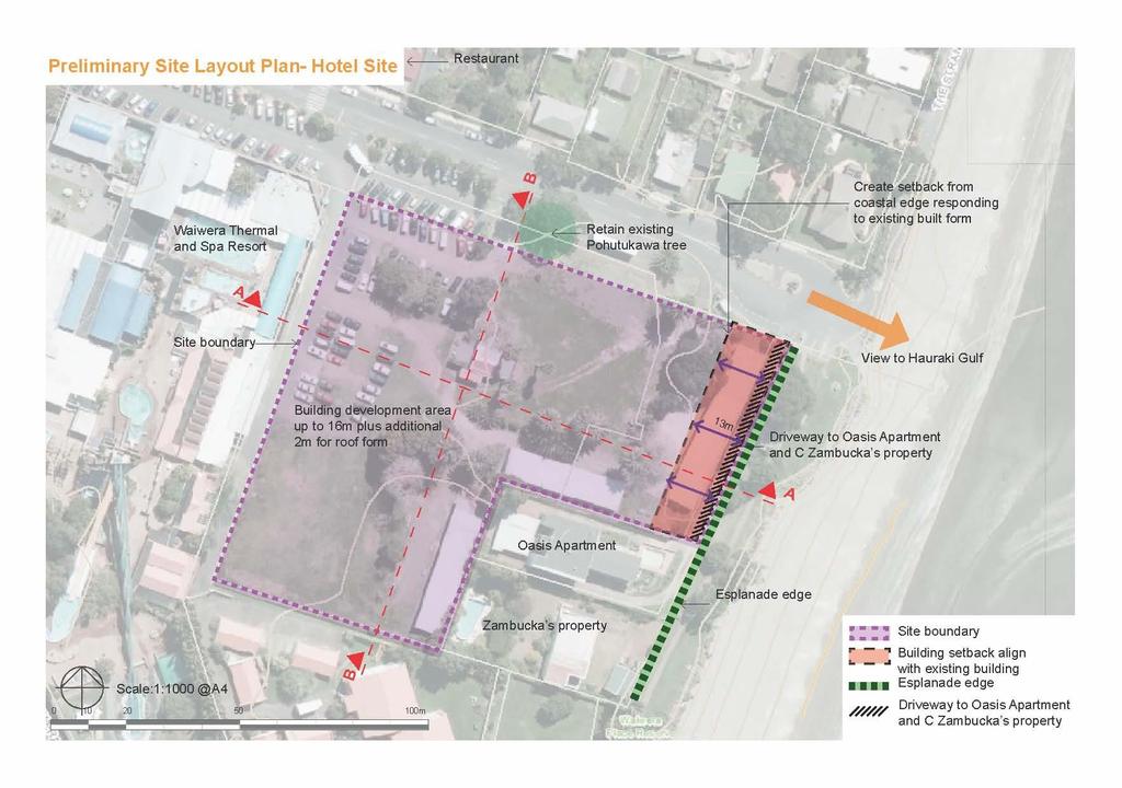
4 3 of the pool site possible redevelopment) of the sites, providing for tourism and visitor needs and revitalising the spa town. 1.5 Waiwera is an enclosed and secluded coastal settlement characterised by the strong vegetated backdrop of Waiwera Hill to the south and the coastal edge to the east. The settlement has an informal holiday town character with a variety of residential styles ranging from single level homes to attached multi-level holiday units. The centre of Waiwera on Waiwera Road is currently poorly defined and degraded. The pool site is in need of upgrading and the adjoining hotel site is largely vacant although it has a long history of use for a hotel dating back to the first hotel built there in the 1840s. 1.6 The Waiwera settlement originally developed and has continued to evolve based around the thermal hot springs and providing recreation and visitor services. Historically, the three sites have been important to the evolution of Waiwera, which is widely acknowledged as New Zealand s first spa resort. The camping ground is the site of the first public bath house to be built in Waiwera and three consecutive waterfront hotels, one of which was particularly prominent, were located on the hotel site. The pool site has provided public pools since The hotels were singularly large iconic facilities that catered for overnight and long-term guests. The hotels were grand designs in timber construction, over three levels high with high roofs and were focal points within the settlement. They were all destroyed by fires and were rebuilt substantially on the same site until the last was demolished in the late 1990 s (the current three wings are the remnants of that building). 1.7 The preliminary site layout plans (refer to Attachment A and B) for the hotel and camping ground, illustrate the proposed height limits and setbacks for buildings on the sites. The schemes while in their development stages only, plan to take account of retaining the character of the coastal edge, streetscape and setting buildings back into the subject sites. 1.8 The layout plan for the hotel site proposes that development activates Waiwera Road and buildings are set back from the coastal edge. A
5 4 building setback of 13m from the esplanade reserve boundary is proposed. The development area will have a maximum occupiable height of 16m with a further 2m for roof form if required. I note that the hotel site is separated from the esplanade reserve by two access strips serving the adjoining properties of Oasis Apartments and C Zambucka. The proposed layout plan for the camping ground site includes 25m a setback from the eastern boundary, restricting the development area to the flat land at the base of Waiwera Hill with a maximum height of 12.5m. 1.9 It is my view that based on the existing urban form of Waiwera, the landscape context and the preliminary site layout plans, it is appropriate that the Unitary Plan allows for maximum occupiable height allowances of 16m on the hotel and pool sites and 12.5 metres on the camping ground site. I consider that development on the hotel and pool sites offers the potential to create a defined centre within the settlement and development on the camping ground site will utilise the secluded camping ground site, whilst maintaining the existing amenity values of Waiwera and the coastal environment. 2. QUALIFICATIONS AND EXPERIENCE 2.1 My name is Garth James Falconer. I am an urban designer and Director of Reset Urban Design Ltd, a consultant practice of six professionals based in central Auckland. Prior to establishing Reset Urban Design, I was a Director of Isthmus Group for over 20 years. 2.2 I hold a Bachelor of Arts degree from Auckland University (1982), a post graduate diploma in Landscape Architecture from Lincoln University (1986) and a Masters degree in Urban Design from Oxford Brookes University, UK (2004). I am a Fellow of the New Zealand Institute of Landscape Architects 2.3 I have over 27 years professional experience. My experience covers a wide range of work around New Zealand, including the Auckland Plan and Auckland Parks Design Guidelines, through to masterplanning
6 5 work on Hobsonville Point, Addison and Redoubt Ridge residential developments in Auckland. 2.4 I appear on behalf of Waiwera Properties Limited ( WPL ) and UP Management Limited ( UPML ) collectively referred to as the Submitters to address the submission made on the PAUP in respect of the Waiwera Precinct Plan. I support the proposed underlying zoning of MUB notified in the PAUP for the hotel and pool sites and the proposed zoning of MHS for the camping ground site. 2.5 In terms of my involvement to date, I reviewed the PAUP and my clients submission. I have reviewed the evidence prepared on behalf of Auckland Council. Therefore, I am familiar with the issues to be addressed at this hearing. 2.6 I confirm that I have read the Expert Witness Code of Conduct set out in the Environment Court's Practice Note I have complied with the Code of Conduct in preparing this evidence and I agree to comply with it while giving oral evidence before the Hearings Panel. Except where I state that I am relying on the evidence of another person, this written evidence is within my area of expertise. I have not omitted to consider material facts known to me that might alter or detract from the opinions expressed in this evidence. 3. SCOPE OF EVIDENCE 3.1 My evidence will address the following: (a) Urban form of Waiwera; (b) Features of the sites and their context including the coastal edge, heritage and landform; (c) Connectivity with the town centre and surrounds; (d) Development within the urban form of Waiwera; (e) Visual amenity and landscape effects; (f) Overall conclusions.
7 6 4. WAIWERA URBAN FORM 4.1 Located 40 minutes north of Auckland city on the Hibiscus Coast Highway, the settlement of Waiwera is a tourism and visitor centre developed around the Waiwera Thermal Pools (the pools). In the 2013 census Waiwera had a small permanent population of 285 people and a total of 297 dwellings. Of these 144 were unoccupied at the time of the census. Waiwera caters for large visitor numbers both local and international throughout the year. In 2002 a total of 305,000 visits per annum were recorded to the pools site, however, it has now reduced to 182,000 visits per annum. 4.2 Waiwera Road is the main road connecting into the settlement and terminating at Waiwera Beach. The road is relatively informal and leads directly to the beach. It is characterised by the pools, the local store, restaurant, a community hall and a small church. Waiwera Place and The Strand are secondary roads within the settlement that primarily provide access to homes. Waiwera Place sits at the base of Waiwera Hill and The Strand follows the coastline east around to the edge of Waiwera Estuary. Refer to figures 1 to The hotel site is located in a prominent position on the waterfront edge (albeit separated from the foreshore by two access strips serving the adjoining properties) at the eastern end of Waiwera Road where it terminates at Waiwera Beach. The Waiwera Thermal Resort is located on the western boundary of the site and is at present the centre of activity in Waiwera. The local store and Sugar Loaf Restaurant are also located on Waiwera Road. Refer to figure The Waiwera Camping Ground is located at the southernmost end of the settlement offering seclusion at the end of the beach up against the headland. Refer to figure Waiwera sits essentially on a small delta wedged between two major headlands on the edge of the Hauraki Gulf. These are Wenderholm Headland to the north and Waiwera Hill to the south. The enclosed settlement is bound by the Waiwera Estuary to the north, Hibiscus Coast Highway to the west, the Hauraki Gulf to the East and the steep
8 7 slopes of the Waiwera Hill to the south. The majority of the settlement is located on the flat land below the Waiwera Hill to the south with properties on the southern edge of the settlement located on the lower slopes. Refer to figures 7 and The settlement pattern has evolved to follow the coast to the north and east taking advantage of ocean and estuary views and accessibility to the water. Development to the south has been limited to the foot of the headland providing a vegetated backdrop to the settlement when viewed from the north. To the west the settlement changes in density opening out as the road follows the edge of the Waiwera River. The settlement terminates approximately 350 metres west of the Hibiscus Coast Highway overbridge. 4.7 A large number of residential properties in Waiwera cater for holiday stays and are baches or rented out accommodation. The built form in Waiwera reflects the established and informal holiday character of the settlement. 4.8 Residential areas in Waiwera range from low-density small residential properties to multi-unit holiday apartments. Properties range in height from one to three level single dwellings such as the properties on the southern side of Waiwera Place to multi-unit properties such as the Waiwera Spa Apartments located at 34 Waiwera Place. Refer to figures 9 and The pool site housing the Waiwera Thermal Resort and Spa is currently the centre of activity within Waiwera and it is characterised by a tall perimeter fence, a collection of buildings and the water slide tower. However, it is currently degraded and underutilised. Visitor numbers are decreasing each year and there has been a number of facilities close due to safety concerns. The vacant camping ground site and the hotel site offer the last remaining opportunities for re-development within the existing limits of the settlement. I note that, as the Submitters also own the ground lease of the pool site future master planning may reconfigure existing activities between Area A and B in the WPP. Refer to figure 11.
9 8 5. SITE DESCRIPTION / CONTEXT 5.1 The hotel site is a large flat property located on the foreshore at the eastern end of Waiwera Road. The site is bound by the coastal esplanade reserve to the east (separated only by two access strips serving the adjoining properties), residential properties to the south, Waiwera Thermal Resort to the west and Waiwera Road to the north. 5.2 The hotel site is located on the main road adjacent to the beach within the centre of commercial and community activities in Waiwera. The hotel site sits centrally between the Waiwera Thermal Resort and Spa, the Sugarloaf Restaurant, local Anglican Church, ramp access onto Waiwera Beach and the coastal esplanade walkway and public toilet block. Zoning in the PAUP and WPP highlights the centre of Waiwera with properties to the north west of the site being zoned Neighbourhood Centre and the pool and hotel sites zoned MUB with the WPP overlay. Refer to figures 12 to The hotel site is comprised of two lots with a total land area of 10,603 square metres. Currently the western end of the site provides informal overflow parking for the Waiwera Thermal Resort and Spa. Three single level accommodation blocks are located at the eastern end of the site, and the centre of the site is grassed and currently not utilised. Established trees frame the site and include pohutukawa, phoenix palms and Washingtonia palms. Dominant trees surveyed on the site range in height from 14.1 metres to 17.5 metres. 5.4 The water slide tower within the Waiwera Thermal Resort and Spa is currently the highest built feature visible from within the site and is approximately 13.8 metres high. 5.5 The camping ground site, is a large, mostly vacant flat lawn and secluded waterfront lot located at the end of Waiwera Place at the southern end of the settlement. The site is bound by the foot of the Waiwera Hill to the south / southwest, residential properties and a recreation reserve to the north and Waiwera Beach to the east.
10 9 5.6 The camping ground site is comprised of two lots totalling 17,781 square metres. Formerly Waiwera Holiday Park, the site is unoccupied with clusters of holiday cabins, the office and ablutions blocks with the derelict historic bathhouse and a large concrete seawall being the only remaining infrastructure on the site. 5.7 The site consists of flat developable land on the coastal frontage and steep vegetated slopes on the northern face of Waiwera Hill. A large single Norfolk pine sits back from the coastal edge; the notable tree is approximately 34.7 metres high and is a dominant feature along the coastal edge. Refer to figures 15 to Immediately adjacent to the east of the camping ground site is the Waiwera Spa Apartments, which were comprehensively developed in the seventies and feature a mediteranean look with terracotta roof tiles and white concrete plaster finish to the facades. The Waiwera Spa Apartments are the highest built feature visible from within the site. The buildings consist of a series of two and three level apartment blocks. The approximate height of the roof apex visible from the camping ground site and adjoining locations is 11.2 metres. Refer to figures 10, 17 and COASTAL EDGE 6.1 The bay is shallow and at low tide the beach extends out over one hundred metres. The coastal edge when viewed from the beach at low tide is characterised by a strong line of properties sitting in front of the dominant and vegetated Waiwera Hill behind. Refer to figure Existing trees break up the built form except to the north, past Waiwera Road along The Strand where the pattern changes and there is little intervening vegetation. Pohutukawa, Norfolk pine and Monterrey cypress form an established vegetation pattern along the southern end of the esplanade reserve from Waiwera Road to the camping ground site and the Waiwera Hill. 6.3 Properties along the coastal edge vary in form and legibility when viewed from a distance. The Waiwera Spa Apartments and modern
11 10 multilevel properties on The Strand are seen clearly in the distant view; however single level properties are not as legible. Refer to figure The setback of buildings along the foreshore is different at the southern and northern ends of the beach. Residential properties at the northern end of the beach sit behind The Strand road reserve and properties at the southern end are set back behind the esplanade reserve and recreation reserve. 6.5 The camping ground and hotel sites form a significant portion of the Waiwera foreshore. The hotel site faces Waiwera Beach and sits behind the coastal esplanade reserve and the access strips serving the adjoining properties. The camping ground site sits immediately on the foreshore behind an existing seawall extending out at the end of the beach. Refer to figures 20 and From the coastal edge, the camping ground site is open aside from the single Norfolk pine and development on the site will be seen with a backdrop of the vegetated slope behind. The hotel site sits within the centre of the settlement and behind the coastal esplanade. Refer to figure HERITAGE 7.1 Waiwera meaning hot water has a long history of use and is one of a number of spa towns developed and promoted to tourists in New Zealand. Waiwera was first developed as New Zealand s earliest spa health resort in 1848 by Robert Graham to take advantage of the thermal mineral water which was very popular throughout the nineteenth and early twentieth centuries for its health giving properties. 7.2 Development has historically been located on the foreshore with the camping ground and hotel sites being amongst the first sites to be developed in Waiwera. In the late 1900 s a four hundred metre long timber jetty was located off the beach as the main access to Waiwera and was regularly serviced by ferry from Auckland.
12 The hotel site was the location of three consecutive hotels. The hotels were dominant features on the foreshore and were the centre of the settlement, accommodating travellers and invalids coming to use the thermal pools. The longest-lived of the series of hotels on the site was an elaborate French Chateau style timber construction in white of three levels plus a very high roof. Refer to figures 22 to Formerly, the Waiwera Holiday Park until 2010, the camping ground site was also the site of the first thermal hot pool to be developed in Waiwera and was part of the hotel facility. The site is a listed historic place and on it sits the remnants of a later spa facility redeveloped on the site in the 1960 s, which is now derelict. Refer to figure 24. A substantial concrete and stone seawall constructed in the early twentieth century edges the site and is still in good condition. 8. CONNECTIVITY 8.1 The camping ground and pool sites sit within the small coastal enclave of Waiwera located approximately 6km north of Orewa and 35km north of Auckland City. Waiwera is accessed via the Hibiscus Coast Highway, which connects through to Orewa to the south, and Puhoi to the northwest. Werenui Road provides a secondary access road into the settlement connecting through to Wainui and Kaukapakapa to the west. 8.2 Waiwera is a very compact settlement with only four roads. The hotel site is located at the end of Waiwera Road, the main road through the settlement. A bus stop is located outside the site on Waiwera Road providing a bus link to Orewa and onto Albany and Auckland City. 8.3 The camping ground site is removed from the main thoroughfare and located at the end of Waiwera Place, which runs up the back of the settlement. Although more secluded the camping ground site is well connected for pedestrians who can link back to the main street and services via the coastal walkway on the edge of the beach. Both the camping ground and hotel sites are within 750m of Hibiscus Coast Highway the main vehicle route back to Auckland central.
13 The camping ground and hotel sites are well positioned within the settlement and connected to recreation opportunities in the area. From the centre of the settlement, it is an easy walk to the Wenderholm Regional Park Perimeter Track or a 5 minute drive into Wenderholm Regional Park and Wenderholm Beach. The Te Araroa National Trail runs through Waiwera, along Waiwera Beach, up past the camping ground site and through to the highway where it connects to the walking trails in Wenderholm Regional Park. 9. PRELIMINARY SITE LAYOUT PLANS 9.1 A preliminary site layout plan has been developed for each of the sites (refer to Attachments A and B). The plans, which are conceptual only detail the appropriate development areas and setbacks and take into consideration site context and the proposed building heights. 9.2 The Preliminary Hotel Site Layout Plan (Attachment A) illustrates a proposed building setback of 13m from the western boundary of the esplanade reserve boundary; the distance is measured from the western boundary of the esplanade reserve and includes the access strips which sit in front of the site. This setback is consistent with neighbouring properties to the south. The maximum height for the development area will be up to 16m plus an additional 2m for roof form. It is envisioned that buildings will be designed to allow for sightlines through to Waiwera Hill to the south. 9.3 It is proposed that significant trees on the site such as the pohutukawa at edge of Waiwera Road are retained and that the buildings are setback to enable sightlines up through to Waiwera Hill to the south. 9.4 No preliminary plan has been prepared for the pool site as it is currently run under lease as the Waiwera Thermal Resort and Spa. Any redevelopment of this site is more likely to involve the reconfiguration and integration of the pool buildings and site layout with development on the hotel site, rather than of the pools themselves. 9.5 The Preliminary Camping Ground Site Layout Plan (Attachment B) proposes to set buildings back 25 metres from the eastern boundary to
14 13 take account of coastal inundation requirements and create an open space strip along the front of the site encompassing the heritage site and the existing Norfolk pine. 9.6 The buildable area with a height limit sought by the Submitters of 12.5 metres, sits on the flat land in front of the existing retaining wall with a backdrop of the vegetated slope behind. It is envisioned that the built form and roofline will be varied and stepped to avoid a solid facade when viewed from the coastline. 10. VISUAL AMENITY AND LANDSCAPE EFFECTS 10.1 An assessment of the settlement and surrounding environment was undertaken to understand the potential visual and landscape effects of the proposed height limits. Fifteen viewpoints were selected as representative of immediate and distant views of each of the sites from public locations The visual assessment focused on the camping ground and hotel sites as the primary development sites but as stated above there is potential for some reconfiguration of buildings on the pool site to occur to achieve an integrated development. I note that the pool site is to the west of the hotel site and would be screened by the hotel development from eastern viewpoints 10.3 Figures 25 to 35 represent immediate views of the camping ground and hotel sites from within the settlement. Immediate views of the hotel development will be seen from Waiwera Road and the esplanade reserve. Development on the site will be viewed in the context of commercial activity on Waiwera Road and a consistent vegetation pattern within and behind the settlement to the south Filtered views out from the centre of Waiwera to Waiwera Hill contribute to the settlement s character. Development on the site needs, where possible, to open up sightlines through the property to allow views through to the south. The anticipated level of visual change in view is considered high when the subject site is viewed from locations opposite the site on Waiwera Road and the corner of Waiwera Road and The
15 14 Strand. However I note that this is in part because people have become accustomed to the hotel site being mainly vacant and grassed. For much of last century it was the site of operating hotels and in the early days a hotel of three storeys in height. Refer to figure As demonstrated on figures 31 and 32 clear views of the camping ground site from within the settlement are available from the esplanade reserve, recreation reserve and the end of Waiwera Place. Development up to three levels will be seen in front of the back drop of Waiwera Hill and will still allow for continuous views of the ridgeline above. Two and three level properties frame views of the site within the settlement The proposed setback of buildings within the camping ground site will screen views of the development from the esplanade reserve as illustrated in figure 35. Views of the site are partially screened by the intervening vegetation and clear sightlines through to the Norfolk pine and heritage site can be retained Figures 36, 37 and 38 represent views of the coastal edge, taken from Waiwera Beach at low tide. The views highlight the flat topography and the dispersion of rooflines through the existing vegetation pattern in the settlement When viewed from Waiwera beach, development on both the camping ground and hotel sites will be contained within the existing limits of the settlement. Buildings up to five levels high on the hotel site will be seen sitting above the existing roofline. Development on the camping ground site will be seen at the southern end of the settlement and will be consistent with the character of the buildings set in front of Waiwera Hill Distant views and elevated views down into Waiwera are available facing south from Hibiscus Coast Highway and Wenderholm Regional Park, refer to figures 39, 40 and 41. Distant views illustrate the enclosed nature of the settlement, characterised by the vegetated headland to the south of the settlement and the flat finger of land, which pushes out into the estuary and Hauraki Gulf.
16 Due to the flat topography, it is considered that from the north, limited views can be obtained of the two sites. From Hibiscus Coast Highway a roofline at 18m with occupiable building height of 16m will be seen sitting within the settlement, however views will be partially screened by the intervening vegetation on the estuary edge Figure 40 illustrates the view from Kokoru Bay in Wenderholm Regional Park over towards Waiwera Beach. From this direction, a small section of the camping ground site is visible to the east of the Norfolk pine limiting views of the development. The limited portion of the proposed development will be seen as an extension of the existing rooflines sitting in front of Waiwera Hill From Kokoru Bay, the roofline of buildings higher than two levels will be seen sitting above existing buildings within the settlement. However, the buildings will be at the centre of the settlement and sit well below the Waiwera Hill ridgeline. It is anticipated that while the hotel site development and any development associated with this on the pool site will change the profile of the settlement it will be appropriate within the settlement pattern Figure 41 illustrates an elevated distant view of Waiwera. When viewed from this direction the change in view is considered to be moderate as the proposed development on both the camping ground and pool sites is seen within the existing vegetation pattern, which partially filter views of the buildings. From this direction, the slide tower (13.5m) within the Waiwera Thermal Resort and the tallest palm trees on the hotel site can be identified Looking down into Waiwera the hotel site development will be seen sitting to the left of the Waiwera Thermal Resort and Spa (unless integrated with the pool site) and sitting above the surrounding buildings but within the profile of the settlement. The camping ground development will be visible sitting at the base of Waiwera Hill and behind the Waiwera Spa Apartment buildings and residential properties on Waiwera Place.
17 Overall it is anticipated that the development on the hotel site will result in a high level of visual change. However the level of change is considered to be appropriate in the context of past development that has existed on the site; the history of consents that have been granted for replacement hotels but have not been implemented; and the importance of redeveloping the centre of Waiwera, to reinstate it as a tourist destination Setting the buildings on the Hotel site back from the coastal edge and encouraging the creation of an active edge on Waiwera Road on the western part of the side opposite the neighbourhood Centre zone, will help to respond to the existing built form, mitigate the high level of visual change from closer viewpoints, particularly from the coastal edge, and create a more defined centre for Waiwera opposite the Neighbourhood Centre zone The development of the camping ground site is considered to result in a moderate level of visual change. The development will sit well into the site and is consistent with the character of the surrounding environment Overall, I consider that the level of visual change from development on the camping ground site to a height of 12.5m including roof form as sought by the Submitters compared with the permitted height of 8m plus 1m for 50% of the roof form is going to be most noticeable from closer viewpoints. From viewpoints that are further away the difference between roof forms of 9m and 12.5m will be less apparent particularly in the context of the roof apex of the Waiwera Spa Apartments at 11.2 metres across Waiwera Place. 11. CONCLUSIONS 11.1 I have reviewed the urban design evidence prepared for Council by Mr M Riley. The evidence does not in my opinion take into account the specific historical development of the sites integral to the spa resort town function of Waiwera or the dominance of the surrounding headlands. It also assumes that the present vacant nature of the three sites forms part of a small coastal village character. In contrast in my
18 17 opinion the sites should be able to be developed as key features of what is a special resort destination, that sits well within a strong headland setting I consider that the proposal to extend the height limit on the hotel and pool sites to align with the underlying MUB height limit of 16m occupy- able height and 2 metres for roof form is appropriate and in keeping with the character of Waiwera when applied within the preliminary site layout plan. I recommend that the setbacks in the preliminary site layout plan in Appendix A be incorporated into the WPP provisions The proposal is in keeping with the heritage of the site as the location of a waterfront hotel and it offers the potential to create a new centre for Waiwera, which also has positive visual effects including activating frontages onto Waiwera Road and the esplanade reserve I believe that an increase in building height within the hotel and pool site that is set back from the coastal edge can be successfully integrated within the built form of Waiwera While the building height will be up to two occupiable levels higher than the tallest residential properties currently in Waiwera, the development is located at the heart of the settlement and will sit against the headland backdrop when viewed from a distance. The development will be set back behind the esplanade reserve reducing visual intrusion on the foreshore and an active edge along Waiwera Road will help support activity alongside the Neighbourhood Centre zone opposite The landscape and visual change resulting from the development of the hotel site and any integration of this with the pool site buildings to the west, will be significant visually when this is assessed against the current development in Waiwera and the vacant state of the hotel site. However, it is still considered appropriate in the context of: i. the vegetated backdrop of Waiwera Hill and the two headlands that frame the settlement; ii. the property itself including its historic use;
19 18 iii. iv. the recognition of Waiwera as a regional tourist attraction and destination as acknowledged in the WPP; the potential to enhance the settlement s centre; and v. the development will be viewed within the existing limits of Waiwera I conclude that the proposal to extend the height limit on the camping ground site to a maximum of 12.5m is appropriate and in keeping with the character of Waiwera when applied within the preliminary site layout plan. I recommend that the setbacks in the preliminary site layout plan in Appendix B be incorporated into the WPP provisions The development of the camping ground site will be set back from the coastal edge and located on the flat land at the base of Waiwera Hill. The buildings will be viewed against the vegetated headland and contained within the existing settlement envelope, reducing the dominance of the buildings in the wider landscape The site is well connected to existing facilities within the community and the development will utilise a currently under-utilised and important site within the settlement by re-establishing tourist facilities on the beachfront Although the development on the camping ground site will result in a visual change, it is considered to be minor, taking into account: i. the site context; ii. iii. iv. past use; the scale of surrounding properties; and the development will be viewed within the existing limits of the settlement Currently the centre of Waiwera is degraded and underutilised. In my opinion development of the hotel and camping ground sites is integral to maintaining Waiwera as a successful and vibrant small coastal settlement, which is focused around the thermal springs. The camping ground and hotel sites represent an opportunity to provide for a broader range of accommodation and services to visitors within Waiwera.
20 19 Through establishing new height limits development can make efficient use of the land available thus re-establishing buildings on the sites and re-establishing the settlement as a spa town I therefore support the proposal to extend the height limits on the hotel and camping ground sites within Waiwera. Garth Falconer 12 February 2016
21 APPENDICES STATEMENT OF EVIDENCE OF GARTH FALCONER ON BEHALF OF WAIWERA PROPERTIES LIMITED AND UP MANAGEMENT LIMITED IN RELATION TO TOPIC 081 REZONING AND PRECINCTS (WAIWERA PRECINCT PLAN) SUBMISSION NO. 1704; FURTHER SUBMISSION FEBRUARY 2016


22 Figure 1: Waiwera Road Figure 2: Commercial Activity on Waiwera Road 2


23 Figure 3: Waiwera Place Figure 4: The Strand Figure 5: Hotel site viewed from the end on Waiwera Road 3
24 Figure 6: Entry off Waiwera Place into secluded camping ground site 4

25 Figure 7: Waiwera Hill behind the settlement to the south Figure 8: Wenderholm Headland sitting behind the settlement 5


26 Figure 9: Waiwera Place, multi level properties Figure 10: Waiwera Spa Apartments Figure 11: Centre of Waiwera, on Waiwera Road 6
27 7


28 Figure 12: Hotel Site facing west Figure 13:Hotel site facing east 8


29 Figure 14: Eastern end of hotel site Figure 15: Camping ground site facing west with Norfolk pine in centre view and Waiwera Spa Apartments in distant view 9


30 Figure 16: Derelict bath house building on southern tip of camping ground site Figure 17: Holiday cabins and ablution block remaining on camping ground site Figure 18: The settlement sitting below Waiwera Hill as seen from Waiwera Beach at low tide 10

31 Figure 19: Established trees in esplanade reserve sitting in front of Waiwera Spa Apartments 11


32 Figure 20: Public toilet block located in esplanade reserve sitting infront of Hotel site Figure 21: Southern end of Waiwera Beach and coastal esplanade reserve with camping ground site sitting at the base of Waiwera Hill Figure 22: Looking south west across the Waiwera River to the jetty and Hot Springs Hotel in the distance. Source: Sir George Grey Special Collections, Auckland Libraries, 4-91 Figure 23: Original Bath House located at the southern end of the beach on the camping ground site. Sourced from Waiwera Resort and Spa website 12

33 Figure 24: Waiwera Hotel seen from jetty, 1903, source: Sir George Grey Special Collections, Auckland Libraries,

34 Representative Viewpoints Figure 25: Viewpoint 1 View standing at the intersection of Waiwera Road and Waiwera Place, facing south east, approximately 150 metres from the hotel site and 350m from the northern boundary of the Camping ground site. The view is seen by people travelling into Waiwera along the main road towards the beach. Marker to highlights top of pohutukawa located in the road reserve, approximately 15.1 metres from GL Figure 26: Viewpoint 2 View standing opposite the Waiwera Thermal Resort entrance at 36 Waiwera Road, facing south east, approximately 50 metres from the hotel site and 300m from the northern boundary of the Camping ground site. The view is seen by people travelling into Waiwera along the main road and people heading to the local restaurant the Waiwera Thermal Resort or accessing the beach. Marker to highlights top of pohutukawa located in the road reserve, approximately 15.1 metres from GL 14
35 15

, approximately 20 metres from the northern boundary")
36 Figure 27: Viewpoint 3A View standing opposite the hotel Site at 46 Waiwera Road, facing south, approximately 20 metres from the northern boundary of the hotel site and 260m from the northern boundary of the Camping ground site. The view is seen by people travelling into Waiwera along the main road down to Waiwera Beach and up to the Waiwera Thermal Resort. Marker highlights top of pohutukawa on hotel site, approximately 14.1 metres from GL Figure 28: Viewpoint 3B View standing opposite the hotel Site at 46 Waiwera Road, facing south west (to the right of Viewpoint 3A), approximately 20 metres from the northern boundary of the hotel site and 260m from the northern boundary of the Camping ground site. The view is seen by people travelling into and out of Waiwera on Waiwera Road and into Waiwera Thermal Resort. 16

37 Figure 29: Viewpoint 4 View standing at the beach end of Waiwera Road at 58 Waiwera Road facing south west, approximately 25 metres from the northern boundary of the hotel site and 240m from the northern boundary of the Camping ground site. The view is seen by people travelling up Waiwera Road from The Strand and those accessing Waiwera Beach to the left of view. Figure 30: Viewpoint 5A View standing on the recreation reserve to the north of the Camping Ground site, facing north, approximately 85 metres from the southern boundary of the hotel site. The view is seen by people utilising the recreation reserve and esplanade reserve to the right of view. Marker highlights top phoenix palm located on hotel site, approximately 17.5 metres from GL 17


38 Figure 31: Viewpoint 5B View standing on the recreation reserve to the north of the Camping Ground site, facing south, approximately 88 metres from the northern boundary of the Camping Ground site. The view is seen by people utilising the recreation reserve and esplanade reserve to the left of view. The end of Waiwera Place is seen at the end of the reserve. Marker highlights top apex of Waiwera Spa Apartments roof, approximately 11.2 metres from GL Figure 32: Viewpoint 6 View from Waiwera Place facing south towards the entry into the Camping Ground site, approximately 14metres north of the site boundary. The view is seen by people travelling along Waiwera Place heading towards Waiwera Beach. Marker highlights top of Norfolk pine on camping ground site, approximately 34.7 metres from GL 18
39 19

40 Figure 33: Viewpoint 7 View from Waiwera Place facing south east towards the entry into the Camping Ground site, standing outside 27 Waiwera Place, approximately 100metres of the site boundary. The view is seen by people travelling along Waiwera Place heading towards the Waiwera Beach end. Marker highlights top of Norfolk pine on camping ground site, approximately 34.7 metres from GL Figure 34 : Viewpoint 8 View standing on the coastal esplanade strip facing south west to the eastern boundary of the hotel site, approximately 16 metres from the eastern boundary of the hotel site and 220m from the northern boundary of the Camping ground site. The view is seen by people utilising the esplanade reserve, coastal walkway and Waiwera Beach and boat ramp. Marker to highlights top of pohutukawa located in the road reserve, approximately 15.1 metres from GL 20
41 21
42 Figure 35: Viewpoint 9 View standing on the Esplanade Reserve at the southern end of Waiwera Beach facing south, approximately 20 metres north of the Camping Ground site. The view is seen by people utilising the esplanade reserve and Waiwera beach. The end of Waiwera Place is seen to the right of view. Figure 36: Viewpoint 10 View from Waiwera beach at low tide on the sand spit where Waiwera River enters the Hauraki Gulf. View taken facing south west towards Waiwera, approximately 500 metres from the eastern boundary of the hotel site and 570m from the northern boundary of the Camping ground site. The view would be seen by people on the beach at low tide or out on the water at high tide. Marker to left highlights top of Norfolk pine on camping ground site, approximately 34.7 metres from GL Marker to right highlights top of phoenix palm located within the hotel site, approximately 15.3 metres from GL 22


43 Figure 37: Viewpoint 11 View from Waiwera beach at low tide standing directly opposite from the hotel site. View taken facing west approximately 250 metres from the eastern boundary of the hotel site and 300metres from the northern boundary of the Camping ground site. The view would be seen by people on the beach at low tide or out on the water at high tide. Marker to left highlights top of Norfolk pine on camping ground site, approximately 34.7 metres from GL Marker to right highlights top of phoenix palm located within the hotel site, approximately 15.3 metres from GL Figure 38: Viewpoint 12 View standing at the southern end of Waiwera beach at low tide opposite the camping ground site. View taken facing west approximately 100metres from the eastern boundary of the Camping ground site and 300 metres from the eastern boundary of the hotel site. The view would be seen by people on the beach at low tide. Marker to left highlights top of Norfolk pine on camping ground site, approximately 34.7 metres from GL Marker to right highlights top apex of Waiwera Spa Apartments roof, approximately 11.2 metres from GL 23


44 Figure 39: Viewpoint 13 View standing on the edge of the Hibiscus Coast Highway on the bridge over the Waiwera River, north of Waiwera. View taken facing south east approximately 500 metres from the northern boundary of the hotel site and 700 metres from the northern boundary of the Camping ground site. The view would be seen by people travelling south over the bridge. Marker highlights top of slide tower within Waiwera Thermal Resort approximately 13.8 metres from GL Figure 40: Viewpoint 14 View standing at Kokoru Bay off the Perimeter Track in Wenderholm Regional Park, looking across to Waiwera Beach facing south, approximately 550 metres from the northern boundary of the hotel site and 750 metres from the northern boundary of the Camping ground site. The view would be seen by people stopping at Kokoru Bay as they walk the Perimeter Track, the view is also representative of views seen the southern base of the Wenderholm headland. Marker highlights top of Norfolk pine on camping ground site, approximately 34.7 metres from GL 24

45 Figure 41: Viewpoint 15 View standing at the side of Hibiscus Coast Highway facing south east towards Waiwera at a bend on the road, approximately 960 metres from the northern boundary of the hotel site and 1km from the northern boundary of the Camping ground site. The viewpoint is representative of an elevated view down into Waiwera available from the highway as you approach the settlement when travelling south. Marker highlights top of slide tower within Waiwera Thermal Resort approximately 13.8 metres from GL 25
46 Attachment A 26
47 27

48 Attachment B 28
49 29
I508. Devonport Peninsula Precinct
 I508. Devonport Peninsula Precinct I508.1. Precinct description The purpose of the Devonport Peninsula precinct is to provide for the comprehensive residential development of the former Navy housing land
I507 Devonport Naval Base Precinct
 I507. Devonport Naval Base I507.1. Precinct Description The Devonport Naval Base precinct covers most of the land held by the Crown for the HMNZ Naval Base (south yard) in Devonport. It incorporates the
URBAN DESIGN REPORT. Proposed Residential Development, Old Church Road, Caledon East
 Proposed Residential Development, Old Church Road, Caledon East TABLE CONTENTS: 1.0 DEVELOPMENT 1.1 Introduction-Analysis of Guiding Principles and Documents 1.2 Community Design and Architectural Design
Spadina Avenue Built Form Study Preliminary Report
 STAFF REPORT ACTION REQUIRED Spadina Avenue Built Form Study Preliminary Report Date: July 9, 2014 To: From: Wards: Reference Number: Toronto and East York Community Council Director, Community Planning,
Supporting information to an application for preapplication 3 rd February 2017
 Development Services, West Lindsey District Council, Guildhall, Marshall s Yard, Gainsborough DN21 2NA Supporting information to an application for preapplication advice. 3 rd February 2017 Proposal for
Section Three, Part 14 Signs
 PART 14 SIGNS SIGNS 14.1 INTRODUCTION This part of the District Plan sets out the requirements in respect of signs. These matters were formerly controlled by bylaws. 14.2 OVERVIEW Signs form an integral
Reference: 06/13/0594/F Parish: Fritton & St Olaves Officer: Mrs M Pieterman Expiry Date:
 Schedule of Planning Applications Committee Date: 21 st January 2014 Reference: 06/13/0594/F Parish: Fritton & St Olaves Officer: Mrs M Pieterman Expiry Date: 20-01-2014 Applicant: Proposal: Site: Lord
401, and 415 King Street West - Zoning Amendment Application - Preliminary Report
 STAFF REPORT ACTION REQUIRED 401, 407-409 and 415 King Street West - Zoning Amendment Application - Preliminary Report Date: January 27, 2011 To: From: Wards: Reference Number: Toronto and East York Community
Schedule of Planning Applications Committee Date: 23 May Reference: 06/18/0064/F Great Yarmouth Officer: Mr J Beck Expiry Date:
 Schedule of Planning Applications Committee Date: 23 May 2018 Reference: 06/18/0064/F Great Yarmouth Officer: Mr J Beck Expiry Date: 24-04-2018 Applicant: Proposal: Site: Mr Mavroudis Clear weather hoardings
Pre-application submission for Committee: Phase 4 development at West Hendon
 Pre-application submission for Committee: Phase 4 development at West Hendon 1. Development Details Phase 4 of the West Hendon Estate Regeneration. 2. Background The redevelopment of the West Hendon Estate
SUMMARY OF DECISIONS REQUESTED
 AUCKLAND UNITARY PLAN OPERATIVE IN PART PROPOSED PLAN CHANGE 12 Hobsonville Corridor Precinct SUMMARY OF DECISIONS REQUESTED Enclosed: Explanation Summary of Decisions Requested 1 of 9 Explanation You
Nov. 29, 2007 PL Ontario Municipal Board Commission des affaires municipales de l Ontario. Judith Sellens and Claire Sellens
 ISSUE DATE: Nov. 29, 2007 PL060515 Ontario Municipal Board Commission des affaires municipales de l Ontario Judith & Claire Sellens have appealed to the Ontario Municipal under subsection 42(6) of the
Bloor Street West Rezoning Application for a Temporary Use By-law Final Report
 STAFF REPORT ACTION REQUIRED 3741 3751 Bloor Street West Rezoning Application for a Temporary Use By-law Final Report Date: June 12, 2007 To: From: Wards: Reference Number: Etobicoke York Community Council
Appendix L Technical Memorandum Aesthetics
 Technical Memorandum Aesthetics 1.0 AESTHETICS This section provides a discussion of the aesthetic resources in the vicinity of ARTIC. Aesthetics pertain to the elements that make a certain view pleasing
Display of 1 no. internally illuminated advertisement hoarding
 Committee Date: 22/08/2013 Application Number: 2013/04695/PA Accepted: 01/07/2013 Application Type: Advertisement Target Date: 26/08/2013 Ward: Ladywood Summer Row, Birmingham, B3 1JU Display of 1 no.
Bridge School, Longmoor Campus, Coppice View Road, Sutton Coldfield, Birmingham, B73 6UE
 Committee Date: 22/01/2015 Application Number: 2014/05949/PA Accepted: 08/12/2014 Application Type: Full Planning Target Date: 02/02/2015 Ward: Sutton Vesey Bridge School, Longmoor Campus, Coppice View
EAST-WEST STITCH. Connecting the Western Edge of the City to the Centre
 98 AC_BEU_CCMP_2_TM1_4 _FD.indd 98 20/07/12 12:06 PM 02 EAST-WEST STITCH Connecting the Western Edge of the City to the Centre 01 02 Northern Motorway Daldy Street Fanshawe Street Nelson Street Hobson
EDEN PARK REDEVELOPMENT COMPLETED STADIUM DESIGN
 1 INTRODUCTION New Zealand was awarded the Rugby World Cup 2011 hosting rights in November 2005. A condition of the winning bid was the provision of a 60,000 seat stadium for the finals. New Zealand s
In the matter of The Resource Management Act And The Queenstown Lakes District proposed District Plan Topic 11 Ski Area Subzones mapping
 Before Queenstown Lakes District Council In the matter of The Resource Management Act 1991 And The Queenstown Lakes District proposed District Plan Topic 11 Ski Area Subzones mapping STATEMENT OF EVIDENCE
E40. Temporary activities
 E40. Temporary activities E40.1. Background Temporary activities contribute to Auckland's vibrancy and to the social, cultural and economic well-being of communities. Temporary activities also enable filming
Land off Stonnal Grove, & Rowden Drive (Phase 1A), Lyndhurst Estate, Sutton Road, Erdington, Birmingham, B23 5US
, Lyndhurst Estate, Sutton Road, Erdington, Birmingham, B23 5US") Committee Date: 07/03/2013 Application Number: 2013/00204/PA Accepted: 11/01/2013 Application Type: Reserved Matters Target Date: 12/04/2013 Development Ward: Erdington Land off Stonnal Grove, & Rowden
Committee Date: 07/03/2013 Application Number: 2013/00204/PA Accepted: 11/01/2013 Application Type: Reserved Matters Target Date: 12/04/2013 Development Ward: Erdington Land off Stonnal Grove, & Rowden
Welcome to our exhibition
 Welcome to our exhibition We are bringing forward a new, employment-led scheme for the Vauxhall Cross Island site in the heart of Vauxhall. We are keen to hear local views on our proposals ahead of submitting
Review of Government Secondary School Requirements within the Sunbury South Precinct Structure Plan
 Review of Government Secondary School Requirements within the Sunbury South Precinct Structure Plan Expert Witness Statement August 11 th, 2017 Prepared by Robert Panozzo Director, ASR Research Pty Ltd
1 INFORMATION REQUIREMENTS
 1 INFORMATION REQUIREMENTS 1.1 BACKGROUND 2 1.2 WHAT IS THE DISTRICT PLAN 3 1.3 DISTRICT PLAN STRUCTURE 4 1.4 HOW TO USE THE DISTRICT PLAN 5 1.5 STRATEGIC FRAMEWORK 6 Whanganui District Plan (15 January
Welcome WINSTON GROUP. Welcome to our public exhibition on the Winston Group s proposals to redevelop 110 Walm Lane, Willesden Green.
 Welcome Our proposed scheme (image for illustrative purposes only) Welcome to our public exhibition on the Winston Group s proposals to redevelop 110 Walm Lane, Willesden Green. The purpose of our exhibition
VISUAL Impact Assessment
 5.0 Existing Landscape Character TO GOULBURN FEDERAL HIGHWAY 5.1 Landscape Character Units Generally one of the first steps in carrying out a landscape and visual assessment is to identify and map the
St. Patrick s Street Development Brief
 St. Patrick s Street Development Brief Bardas Chorcai Cork Corporation August 2001 Contents Introduction and background The Development Brief Area Protected and valuable buildings Urban context Objectives
The Sunshine Coast is part of the global community and generates wealth through export, high-value industries and new investment.
 3.2 Strategic intent 3.2.1 Shaping growth an overview In 2031, the Sunshine Coast is renowned for its vibrant economy, ecological values, unique character and strong sense of community. It is Australia
2433 Dufferin Street Zoning By-law Amendment Application - Preliminary Report
 STAFF REPORT ACTION REQUIRED 2433 Dufferin Street Zoning By-law Amendment Application - Preliminary Report Date: July 22, 2014 To: From: Wards: Reference Number: North York Community Council Director,
F6. Coastal Ferry Terminal Zone
 F6. Coastal Ferry Terminal Zone F6.1. Zone description The purpose of the Coastal Ferry Terminal Zone is to provide for the integrated and efficient operation and development of ferry terminal facilities.
TOWN PLANNING SUBMISSION TO THE GREATER SYDNEY COMMISSION LANDS AT ARTARMON
 TOWN PLANNING SUBMISSION TO THE GREATER SYDNEY COMMISSION LANDS AT ARTARMON March 2017 TABLE OF CONTENTS 1.0 INTRODUCTION 3 2.0 THE SUBJECT SITE 4 3.0 STRATEGIC PLANNING CONTEXT 6 4.0 SUMMARY AND CONCLUSIONS
The original needs analysis carried out in 2001 identified three options for acquiring or leasing land for the crèche:
 5. REDCLIFFS/SUMNER COMMUNITY CRÈCHE RELOCATION Officer responsible Author Property Manager Kevin Mara, DDI 941 6401 The purpose of this report is to update the Council on the status of this project, in
Section 61 Recreational Vehicle Park / Campground (Bylaw No. 2012/10)
") Part 7 General Regulations Section 61 Recreational Vehicle Park / Campground (Bylaw No. 2012/10) 61.1 A comprehensive site plan shall be provided to the satisfaction of the Development Authority that shows
Part 7 General Regulations Section 61 Recreational Vehicle Park / Campground (Bylaw No. 2012/10) 61.1 A comprehensive site plan shall be provided to the satisfaction of the Development Authority that shows
Hamilton School, Hamilton Road, Birmingham, B21 8AH
 Committee Date: 12/12/2013 Application Number: 2013/07822/PA Accepted: 17/10/2013 Application Type: Full Planning Target Date: 12/12/2013 Ward: Handsworth Wood Hamilton School, Hamilton Road, Birmingham,
Old Limberlost Sports Club, Butlers Road, Handsworth Wood, Birmingham, B20 2NT
 Committee Date: 07/03/2013 Application Number: 2012/07986/PA Accepted: 29/11/2012 Application Type: Variation of Condition Target Date: 24/01/2013 Ward: Handsworth Wood Old Limberlost Sports Club, Butlers
HARBOUR EDGE STITCH. Uniting the Waterfront with the City Centre
 78 AC_BEU_CCMP_2_TM1_4 _FD.indd 78 20/07/12 12:04 PM 01 HARBOUR EDGE STITCH Uniting the Waterfront with the City Centre 01 VISION OUR 2032 VISION IS: Quay Street as a high-quality Harbour Edge space that
APPLICATION No. D/2016/476. Members of 2011 Residents Association object to this proposal and provide the following reasons for our objection:
 8 June 2016 APPLICATION No. D/2016/476 118A DARLINGHURST ROAD, DARLINGHURST NSW 2010 Members of 2011 Residents Association object to this proposal and provide the following reasons for our objection: Background:
Director, Community Planning, Toronto and East York District
 STAFF REPORT October 25, 2005 To: From: : Subject: Toronto and East York Community Council Director, Community Planning, Toronto and East York District Status Report OPA & Rezoning Application 05 117524
Volume Three. 3.9 Planning Area No. 9 North Shore Location and Role Vision Statement Key Character Elements
 3.9 Planning Area No. 9 North Shore 3.9.1 Location and Role This Planning Area includes the Sunshine Coast Airport and surrounding lands, including the localities of Mudjimba, Pacific Paradise, North Marcoola
A21 TONBRIDGE TO PEMBURY DUALLING. Statement of Case
 A21 TONBRIDGE TO PEMBURY DUALLING Statement of Case In Respect of Applications for the Demolition of Listed Buildings Under the Provisions of the Planning (Listed Buildings and Conservation Areas) Act
Date: 11 th January, From: Plaistow & Ifold Parish Neighbourhood Plan - Steering Group. Plaistow & Ifold Parish Council
 Date: 11 th January, 2017 From: Plaistow & Ifold Parish Neighbourhood Plan - Steering Group To: Plaistow & Ifold Parish Council Re: Neighbourhood Plan Report to Parish Council Meeting 17 Jan 2017 The Steering
Concept Curtin Precinct Map and Code
 Concept Curtin Precinct Map and Code Proposed changes from the revised Curtin Group Centre Draft Master Plan recommendations Disclaimer: This document is intended to show the proposed changes to the existing
PSP 75 Lancefield Road. Northern Jacksons Creek Crossing Supplementary Information
 PSP 75 Lancefield Road Northern Jacksons Creek Crossing Supplementary Information September 2017 The northern crossing of Jacksons Creek proposed within the Lancefield Road PSP is a key part of the ultimate
Amendments C207 & C208
 Amendments C207 & C208 Hume Planning Scheme Julia Bell August 2017 Instructed by KING&WOOD MALLESONS On behalf of Hume City Council Amendments C207 & C208 Hume Planning Scheme Contents 1.0 Introduction...
Bartlett Square Welcome. Investment Framework. London Airport Ltd
 1 Welcome Welcome to Luton s public exhibition on proposals for the (formerly known as Stirling Place) project which will comprise 2.5 acres of commercial development, providing up to 2,000 jobs for local
DRAFT PLAN OF MANAGEMENT MASSY GREENE
 DRAFT PLAN OF MANAGEMENT MASSY GREENE The draft Plan of Management for the Reflections Holiday Parks Massy Greene is on public exhibition from Monday, 19 November 2018 to Sunday, 6 January 2019. The plans
Ms P Goldfinger Date: 18 September 2017 Head of Programme The Architecture Centre Our Ref: M15/
 Unit 2 Eclipse Office Park High Street Staple Hill Bristol BS16 5EL T: 0117 956 1916 E: all@tetlow-king.co.uk F: 0117 970 1293 W: www.tetlow-king.co.uk Ms P Goldfinger Date: 18 September 2017 Head of Programme
Sainsburys Store, Mere Green Road, Sutton Coldfield, Birmingham, B75 5BT
 Committee Date: 7/0/013 Application Number: 013/04/PA Accepted: 1/04/013 Application Type: Variation of Condition Target Date: 1/07/013 Ward: Sutton Four Oaks Sainsburys Store, Mere Green Road, Sutton
01 INTRODUCTION. Student Learning Hub University of Bristol, Beacon House. Proposals for Beacon House. Have your say
 01 INTRODUCTION Proposals for Beacon House Welcome to this exhibition which shows proposals being brought forward by the University of Bristol to refurbish and improve Beacon House (former Habitat Building)
I214. Wynyard Precinct
 I214. Wynyard Precinct I214.1. Precinct description The Wynyard Precinct represents the north-western end of the city centre. The land is bound on three sides by the sea and by Fanshawe Street on its southern
Alternative Highest & Best Use Analysis Boutique Hotel
 Alternative Highest & Best Use Analysis In response to numerous comments received from the public, as well as issues raised by the CCC in the Appeal Staff Report Substantial Issue Determination, the following
I211. Viaduct Harbour Precinct
 I211. Viaduct Harbour Precinct I211.1. Precinct description The Viaduct Harbour precinct incorporates Viaduct Harbour and the land fronting the harbour (including Hobson Wharf), and the adjacent coastal
REGIONAL BOARD REPORT
 REGIONAL BOARD REPORT Administrator s Office For the Board August 21, 2008 DATE: August 14, 2008 FILE NOS.: A-07-06377/8/9.000 FROM: RE: Chief Administrative Officer OCP and Zoning Amendment Application
COLLEGE STREET STUDY Community Consultation Meeting. December 2015
 COLLEGE STREET STUDY Community Consultation Meeting December 2015 2 Agenda 6:30 pm Introductions, Agenda Review and Welcome 6:40 pm Presentation Planning Recommendations 7:30 pm Questions and Discussion
Appendix 7 Local Green Spaces - Detailed Evidence
 Appendix 7 Local Green Spaces - Detailed Evidence Neigh Bridge Country Park, Somerford Keynes General information Neigh Bridge Country Park is situated at the southern entrance to Somerford Keynes village.
SnowdoniaNationalParkAuthority SupplementaryPlanningGuidance: VisitorAccommodation October2012
 SnowdoniaNationalParkAuthority SupplementaryPlanningGuidance: VisitorAccommodation October2012 8 SNOWDONIA NATIONAL PARK AUTHORITY SUPPLEMENTARY PLANNING GUIDANCE: 8 VISITOR ACCOMODATION Contents 1 Introduction...
East Melbourne Precinct HO2. March 2015
 East Melbourne Precinct HO2 March 2015 Local Heritage Planning Policy Review Statements of Significance Melbourne s Local Heritage Planning Policy Review project includes the preparation of statements
PCAL Case Study Retail Areas: Rouse Hill Town Centre
 PCAL Case Study Retail Areas: Rouse Hill Town Centre Introduction Rouse Hill Town Centre is a new mixed use development on a greenfield site in Sydney s North West. It has been planned to be a major hub
Table of Contents. Location... 1 Cultural Heritage Value... 3 Site History... 4 Physical Description... 6 Conclusion... 7 Sources...
 Executive Summary The Outdoor Firing Range, located west of the Small Arms Building at 1300 Lakeshore Road East, merits designation under the Ontario Heritage Act for its historical, architectural and
NEWBORO AND PORTLAND HARBOUR REDVELOPMENT PLANS
 INTRODUCTION The Municipal docks in both Newboro and Portland were transferred to the Township of Rideau Lakes by Parks Canada in 2002. Little has been done to improve the docks physical condition or role
Sunshine Coast Airport Master Plan September 2007
 Sunshine Coast Airport Master Plan September 2007 Contents CONTENTS... I ACKNOWLEDGEMENT... II DISCLAIMER... III 1 EXECUTIVE SUMMARY...IV 1 INTRODUCTION... 1 2 AVIATION DEMAND FORECAST... 5 3 AIRCRAFT
places Mooloolaba s heart five
 five places the mooloolaba heart 1 Flexible community event use of school oval 2 Enhanced streetscape District cycle route Future cross-block pedestrian link 5 Existing school buildings New signalised
PROTECTED AREAS ZONE - POLICY
 PROTECTED AREAS ZONE - POLICY.1 Introduction The Protected Areas Zone applies to the land depicted on the Ruapehu District Plan Maps as: Amenity Policy Area. Protected Areas - Conservation. (c) Protected
BEFORE THE AUCKLAND UNITARY PLAN INDEPENDENT HEARINGS PANEL AND AND STATEMENT OF PRIMARY EVIDENCE OF MARK ALLEN VINALL ON BEHALF OF AUCKLAND COUNCIL
 BEFORE THE AUCKLAND UNITARY PLAN INDEPENDENT HEARINGS PANEL IN THE MATTER of the Resource Management Act 1991 and the Local Government (Auckland Transitional Provisions) Act 2010 AND IN THE MATTER of Topic
4.0 Context for the Crossing Project
 4.0 Context for the Crossing Project This section provides background information about key features of the North Douglas Crossing project area, and opportunities and constraints. This information is important
Development Watch Inc PO Box 1076, Coolum Beach, QLD, 4573
 Development Watch Inc PO Box 1076, Coolum Beach, QLD, 4573 ABN 53 627 632 278 www.developmentwatch.org.au 26 June 2013 The Chief Executive Officer Sunshine Coast Council PO Box 76 NAMBOUR QLD 4560 (By
CANNING CITY CENTRE. the new energy of the southeast
 CANNING CITY CENTRE the new energy of the southeast 2 INTRODUCTION From early beginnings as an important cultural and recreation place for the Beeloo Nyoongar people, to being a trading post connecting
Nelson Mandela Community School, Colville Road, Sparkbrook, Birmingham, B12 8EH. Erection of single storey detached learning pod building
 Committee Date: 7/07/204 Application Number: 204/0362/PA Accepted: 22/05/204 Application Type: Full Planning Target Date: 7/07/204 Ward: Sparkbrook Nelson Mandela Community School, Colville Road, Sparkbrook,
An Assessment of Lower Boddington
 W An Assessment of Lower Boddington Design and Conservation Team Reviewed Winter 2017 Contents Introduction... 2 Origins and Archaeology... 3 Historic Development... 3 Plan Form... 3 Space and relationship
317a & 400 Hoe Street, Walthamstow, E17 9AA
 North East London Residential Led Development Opportunity 317a & 400 Hoe Street, Walthamstow, E17 9AA Red line boundary for indicative purposes only Summary Residential-led two-site development opportunity
SUMMER VILLAGE OF SILVER SANDS. Municipal Development Plan
 SUMMER VILLAGE OF SILVER SANDS Municipal Development Plan Bylaw 253-2014 Adopted August 22, 2014 Summer Village of Silver Sands Municipal Development Plan Bylaw No. 253-2014 Page 2 1 INTRODUCTION 1.1 SETTING
Submission on Draft Ingleburn Structure Plan. Prepared for: Ingleburn Chamber of Commerce & Industry Inc. 6 February 2015
 Submission on Draft Ingleburn Structure Plan Prepared for: Ingleburn Chamber of Commerce & Industry Inc. GLN Planning Pty Ltd ABN 39 585 269 237 Level 10, 66 King Street Sydney NSW 2000 GPO Box 5013 Sydney
Green Fields Leppington
 Green Fields Leppington CONNTENTS 1.0 URBAN GROWTH - SYDNEY 2.0 MACRO CONTEXT 3.0 LOCAL ENVIRONMENTAL PLAN - LEPPINGTON 4.0 CONCEPT 5.0 GREEN ROOFS 6.0 APARTMENT REALISATION SCHEDULE 7.0 INFRASTRUCTURE
3. COLTA / HUGA CONNECTIONS - PRELIMINARY
 9 3. COLTA / HUGA CONNECTIONS - PRELIMINARY 3.1 COLTA The Chain of Lakes Trail Association (COLTA) trail, formerly identified as the Chester Spur Line, was completed and opened for use in June 2011. The
2.2 For these reasons the provision of tourist signing will only be considered:
 TOURIST SIGNING POLICY 2015 1. DEFINITION 1.1 A tourist destination is defined as a permanently established attraction which attracts or is used by visitors to an area and is open to the public without
I200. Arts, Civic and Entertainment Precinct
 I200. Arts, Civic and Entertainment Precinct I200.1. Precinct description The Arts, Civic and Entertainment Precinct is located at the head of the Queen Street Valley. Auckland s major arts and entertainment
Display of 1 no. illuminated large format advert hoarding
 Committee Date: 15/05/2014 Application Number: 2014/01081/PA Accepted: 20/03/2014 Application Type: Advertisement Target Date: 15/05/2014 Ward: Nechells Moat Lane Car Park, Digbeth, Birmingham, B5 5BD
SUBMISSION BY THE BOARD OF AIRLINE REPRESENTATIVES OF NEW ZEALAND ON THE DRAFT QUEENSTOWN LAKES DISTRICT COUNCIL DRAFT PLAN
 SUBMISSION BY THE BOARD OF AIRLINE REPRESENTATIVES OF NEW ZEALAND ON THE DRAFT QUEENSTOWN LAKES DISTRICT COUNCIL DRAFT PLAN Background to BARNZ BARNZ is an incorporated society comprising 19 member airlines
Shadow Impact Assessment & 2323 Lake Shore Boulevard West. Etobicoke, Ontario
 Shadow Impact Assessment 2313 & 2323 Lake Shore Boulevard West Etobicoke, Ontario REPORT: GWE12-099-SHADOWS-2014 Prepared For: Peter Swinton, B.Arch., MCIP, RPP PMG Planning Consultants 227 Bridgeland
General Summer and Winter Views
 ENVIRONMENTAL INFORMATION REPORT VOLUME 4 APPENDIX 11. 2 General Summer and Winter Views Table of Contents Section APPENDIX 11.2 Page 1 General Views... 1-1 Tansy Lane, Portishead... 1-2 Galingale Way,
9.1 INTRODUCTION 9.2 EXISTING DEVELOPMENT. Southern Cross University
 Property Strategy The property strategy delivers improved legibility, responds to the locational attributes of the site, and facilitates essential operational efficiencies. 9.1 INTRODUCTION Non-aviation
Perth and Kinross Council Development Control Committee 27 August 2008 Recommendation by Development Quality Manager
 Perth and Kinross Council Development Control Committee 27 August 2008 Recommendation by Development Quality Manager 5(7) 08/414 Erection of kennels and cattery at Baltree Farm, Hatchbank, Kinross, KY13
Historical value The building was erected on a new site to serve a new meeting and in itself is of low historical value.
 Quaker Meeting House, Welwyn Garden City 109 Handside Lane, Welwyn Garden City, Hertfordshire, AL8 6SP National Grid Reference: TL 23149 12617 Statement of Significance As first built in 1926 to the designs
David acts an Independent Hearing Commissioner and has considered plan changes, resource consents and notices of requirements.
 Director David is a Director with Hill Young Cooper Ltd, a resource management, environmental policy and planning consultancy with offices in Auckland and Wellington. David has over 25 years experience
12, 14 and 16 York Street - Amendments to Section 16 Agreement and Road Closure Authorization
 REPORT FOR ACTION 12, 14 and 16 York Street - Amendments to Section 16 Agreement and Road Closure Authorization Date: April 27, 2018 To: Toronto and East York Community Council From: Senior Strategic Director,
CITY & COUNTY OF SWANSEA SWANSEA TALL BUILDINGS STRATEGY STATEMENT OF REPRESENTATION
 CITY & COUNTY OF SWANSEA SWANSEA TALL BUILDINGS STRATEGY STATEMENT OF REPRESENTATION On Behalf of: Mr Garip Demirci Relating to: Proposal: Site: Swansea Tall Buildings Strategy Inclusion of land in the
WELCOME TO PROJECT EVERGREEN 3 CHILTERN S PROPOSED NEW OXFORD TO LONDON ROUTE
 PROJECT EVERGREEN 3 WELCOME TO PROJECT EVERGREEN 3 CHILTERN S PROPOSED NEW OXFORD TO LONDON ROUTE Chiltern Railways is proposing a railway improvement scheme between Oxford and Bicester (the Evergreen
PRINCEGATE HOUSE DONCASTER, DN1 3EN. Well Located Strategic Investment/Development Opportunity with Short Term Government Income
 INVESTMENT SUMMARY Prominent location in the heart of Doncaster town centre situated on Princegate. Freehold. Ideally located close to the Waterdale Shopping Centre and the recently regenerated new 300
CITY RAIL LINK. New Public Transport Stations and Development Opportunities at Karangahape Road, Newton and Aotea Quarter
 134 AC_BEU_CCMP_3_TM5_8_FD.indd 134 20/07/12 12:30 PM 05 CITY RAIL LINK New Public Transport Stations and Development Opportunities at Karangahape Road, Newton and Aotea Quarter 5 MO VE 0 1 2 8 KEY 1 Britomart
CHRISTCHURCH MOTORWAYS. Project Summary Statement February 2010
 CHRISTCHURCH MOTORWAYS Project Summary Statement February 2010 Table of Contents 1. Purpose of Document 2. Strategic Context 3. Benefits 4. Project Scope and Economics 5. Implementation Plan 1 ROADS OF
APPENDIX E. Urban Design
 APPENDIX E Urban Design energy2u Alliance North Sydney Zone Substation Redevelopment September 2010 E August 2010 North Sydney Zone Substation Redevelopment Urban Design Impacts on 136-140 Walker Street
Ms J Delouche Sea View Cottage Cliff Road Margrave-on-Sea MUDHOLE ML20 7AX 15 October 2015
 Hazy Beacon District Council Chief Executive s Department Town Hall St Nicholas Street Mudhole ML16 3BY Ms J Delouche Sea View Cottage Cliff Road Margrave-on-Sea MUDHOLE ML20 7AX 15 October 2015 Dear Mr
DESIGN CONTROL GUIDELINES NORTHLAKE HOME LOTS
 www.northlake.co.nz DESIGN CONTROL GUIDELINES NORTHLAKE HOME LOTS NORTHLAKE PHILOSOPHY The stunning landscape of Northlake is deserving of protection, as is your investment in your Northlake property.
FURTHER SUBMISSION BY THE BOARD OF AIRLINE REPRESENTATIVES OF NEW ZEALAND ON THE DRAFT QUEENSTOWN LAKES DISTRICT COUNCIL DRAFT PLAN
 FURTHER SUBMISSION BY THE BOARD OF AIRLINE REPRESENTATIVES OF NEW ZEALAND ON THE DRAFT QUEENSTOWN LAKES DISTRICT COUNCIL DRAFT PLAN BARNZ is an incorporated society comprising 20 member airlines operating
Whangarei Airport. Prepared by Carine Andries 10/20173
 Whangarei Airport Prepared by Carine Andries 10/20173 March 2010 TABLE OF CONTENTS 1 2 3 INTRODUCTION... 3 AIRPORT ROLE AND FUNCTION... 3 AIRPORT FEATURES AND CAPACITY... 3 3.1 3.2 3.3 3.4 3.5 3.5.1 3.5.2
Draft Planning Controls Planning Scheme Amendment GC81
 Draft Planning Controls Planning Scheme Amendment GC81 Peita Tapper Senior Planner, Planning Services What the planning controls do? The draft planning controls translate the objectives and strategies
Heritage Character Area Zoning - Edmonton s Approach to Preserving(?) Community Character
 Community Character") Heritage Character Area Zoning - Edmonton s Approach to Preserving(?) Community Character Federation of Calgary Communities Community Planning Exchange November 4, 2017 City of Edmonton CITY
Heritage Character Area Zoning - Edmonton s Approach to Preserving(?) Community Character Federation of Calgary Communities Community Planning Exchange November 4, 2017 City of Edmonton CITY
VOLUME 3 3. STATEMENTS OF DESIRED CHARACTER FOR PLANNING AREAS AND PRECINCTS. 3.1 Planning Area No. 1 - Maroochydore
 3. STATEMENTS OF DESIRED CHARACTER FOR PLANNING AREAS AND PRECINCTS 3.1 Planning Area No. 1 - Maroochydore The Maroochydore Principal Activity Centre is subject to the Maroochydore PAC Structure Plan.
EVIDENCE OF GORDON DESMOND MOLLER ONZM ON BEHALF OF PANUKU DEVELOPMENT AUCKLAND (ARCHITECT) 7 AUGUST 2018
 7 AUGUST 2018") 0117 BEFORE THE ENVIRONMENT COURT I MUA I TE KOOTI TAIAO O AOTEAROA ENV-2018-AKL-000078 IN THE MATTER of the Resource Management Act 1991 (RMA) AND IN THE MATTER BETWEEN of the direct referral of applications
0117 BEFORE THE ENVIRONMENT COURT I MUA I TE KOOTI TAIAO O AOTEAROA ENV-2018-AKL-000078 IN THE MATTER of the Resource Management Act 1991 (RMA) AND IN THE MATTER BETWEEN of the direct referral of applications
UNDER the Resource Mangement Act 1991 PANUKU DEVELOPMENT AUCKLAND. Applicant AUCKLAND COUNCIL. Regulatory Authority
 2002 BEFORE THE ENVIRONMENT COURT AT AUCKLAND ENV-2018-AKL-000078 UNDER the Resource Mangement Act 1991 IN THE MATTER BETWEEN of the direct referral of applications for resource consent for the necessary