Lynde Creek Watershed. Lynde Creek Watershed CLOCA LYNDE CREEK WATERSHED EXISTING CONDITIONS REPORT CHAPTER 1 STUDY AREA
|
|
|
- Angel McKenzie
- 5 years ago
- Views:
Transcription


1 Lynde Creek Watershed CLOCA Lynde Creek Watershed CLOCA LYNDE CREEK WATERSHED EXISTING CONDITIONS REPORT CHAPTER 1 STUDY AREA June 2008
2 TABLE OF CONTENTS 1.0 STUDY AREA Lynde Main Subwatershed Heber Down Subwatershed Kinsale Subwatershed Ashburn Subwatershed Myrtle Station Subwatershed...14 LIST OF FIGURES Figure 1: Lynde Creek watershed Figure 2: Lynde Main subwatershed Figure 3: Heber Down subwatershed... 9 Figure 4: Kinsale subwatershed Figure 5: Ashburn subwatershed Figure 6: Myrtle Station subwatershed Page 2 of 15
.")
3 1.0 STUDY AREA The Lynde Creek Watershed is located at the western end of Central Lake Ontario Conservation s jurisdiction. The Lynde Creek and its tributaries drain an area of approximately 130 km2 (Figure 1). The northern part of this watershed abuts the Nonquon River Watershed in Kawartha Region Conservation s jurisdiction and the western side of the watershed lies adjacent to Carruthers Creek Watershed which is in the jurisdiction of the Toronto and Region Conservation Authority. The northern half of the east side of this watershed abuts the Oshawa Creek Watershed, while the southern half lies beside the Pringle Creek Watershed. The watershed is located entirely within the Regional Municipality of Durham and traverses five local municipalities (Town of Uxbridge, Township of Scugog, City of Pickering, Town of Ajax, and the Town of Whitby). the Lynde Creek and its tributaries drain an area of approximately 130 km2 Lynde Creek Watershed CLOCA The watershed drains southerly towards Lake Ontario, from its headwaters in the Oak Ridges Moraine (ORM) and empties into Lake Ontario through Lynde Creek Marsh, a coastal wetland. Cutting through the middle of this watershed is the shoreline of glacial Lake Iroquois. This shoreline deposit is predominantly comprised of sand and gravel. The Lake Iroquois Shoreline and the Oak Ridges Moraine (ORM) are dominant features within the watershed playing a role in some of the natural features and functions that exist within the watershed. Page 3 of 15


4 Figure 1: Lynde Creek watershed. Page 4 of 15

5 Chalk Lake is a unique feature that exists in the north portion of this watershed. Chalk Lake is the only kettle lake within CLOCA s jurisdiction. Another important feature is the Lynde Creek Marsh which is a Provincially significant coastal wetland complex. Although CLOCA has a number of coastal wetlands, there are not many of these wetlands left along the Lake Ontario shoreline, offering another rare find within the Lynde Creek watershed. A diverse landscape exists within the Lynde watershed which includes urban settlements, rural settlements, agriculture, and natural areas, all having various and different influences and impacts on the watershed. The urban area of the Town of Whitby occupies most of the south, with Lynde Shores Conservation Area forming the dominant open space on the Lake Ontario waterfront. The Village of Brooklin is located about half way between the top and bottom of the watershed. A few hamlets are scattered throughout the watershed with the hamlets of Myrtle, Myrtle Station, and Ashburn situated in the north portion of the watershed. The hamlets of Kinsale and Macedonian Village are in the middle of the watershed, with Almond Village located in the south portion of the watershed. Generally, within the rural area, agricultural activities are prevalent. The watershed has been divided into 5 subwatersheds: Lynde Main, Heber Down, Kinsale, Ashburn and Myrtle Station. a Kettle Lake is a depression formed by glacial action and permanently filled with water Ministry of the Environment a diverse landscape exists within the Lynde watershed which includes urban settlements, rural settlements, agriculture, and natural areas, all having various and different influences and impacts on the watershed Lynde Creek Watershed Lou Wise Page 5 of 15

6 1.1 Lynde Main Subwatershed The Lynde Main subwatershed (Figure 2) drains an area of almost 3000 ha (30 km 2 ). A substantial amount of the built up area of Whitby, including Brooklin, is found in this subwatershed, however there are no hamlets located in this area. Between Whitby and Brooklin, agricultural and rural land uses dominate. About 16% of this subwatershed is situated within the Greenbelt. While the provincial Greenbelt Plan includes lands within the ORM, for the purpose of the discussion within this chapter, lands within the Greenbelt exclude those within the ORM (see Chapter 4 Land use and Policy, for more detail). The amount of Lake Iroquois Shoreline within this subwatershed is also 16%. A very small portion (less than 1%) of this subwatershed is within the ORM. At the south end of this subwatershed are the Lynde Creek Marsh and Lynde Shores Conservation Area. A portion of the Heber Down Conservation Area is located within this subwatershed. the Lynde Main subwatershed drains an area of almost 3000 ha Lynde Main Subwatershed Lou Wise Page 6 of 15

7 Figure 2: Lynde Main subwatershed. Page 7 of 15

8 1.2 Heber Down Subwatershed Heber Down subwatershed (Figure 3) is the largest subwatershed draining approximately 4600 ha (46 km 2 ). The headwaters of this subwatershed reach into the Oak Ridges Moraine, with the south portion draining into the Lynde Main just north of Dundas Street in the urban area of Whitby. The ORM and Greenbelt lands outside of the ORM represent a major portion of this subwatershed, having 18% and 40% respectively of the land area. Just over 15% of this subwatershed is within the Lake Iroquois Shoreline. The western portion of Brooklin and the hamlet of Macedonian Village are situated within this subwatershed. Heber Down Conservation Area is located within this subwatershed. Heber Down subwatershed is the largest subwatershed draining approximately 4600 ha Heber Down Subwatershed Lou Wise Page 8 of 15

9 Figure 3: Heber Down subwatershed. Page 9 of 15
 of land. The subwatershed contains three local municipalities including the Town of Whitby, Town of Ajax and City of Pickering.")
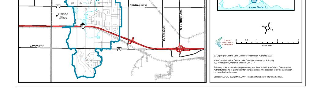
10 1.3 Kinsale Subwatershed The Kinsale subwatershed (Figure 4) intersects with the Lynde Main subwatershed at the southern end within the Lynde Creek Marsh. This subwatershed drains about 2200 ha (22 km 2 ) of land. The subwatershed contains three local municipalities including the Town of Whitby, Town of Ajax and City of Pickering. Urban development within this subwatershed is less dominant, with agricultural and rural land uses predominating. The hamlets of Kinsale and Almond Village are found within this subwatershed. A major portion of this subwatershed (56%) is within the Greenbelt, and 17% is within the Lake Iroquois Shoreline. This is the only subwatershed that does not have any lands within the Oak Ridges Moraine. With respect to Conservation Area land holdings, in addition to Lynde Shores Conservation Area, the Audley Road Woods are situated within this subwatershed. the Kinsale subwatershed drains about 2200 ha (22 km 2 ) of land Kinsale Subwatershed Lou Wise Page 10 of 15
11 Figure 4: Kinsale subwatershed. Page 11 of 15

12 1.4 Ashburn Subwatershed The Ashburn subwatershed is located within the upper reaches of this watershed. This subwatershed drains about 1700 ha (17 km 2 ) of land (Figure 5). The hamlet of Ashburn is located in this subwatershed. Agricultural land uses are dominant on the lands south of the moraine. Only a small portion of this subwatershed, located in the south, is not within the Oak Ridges Moraine or the Greenbelt. In fact, 80% of this subwatershed is in the ORM and 18% is in the Greenbelt outside of the ORM. A portion of Crow s Pass Conservation Area is found in this subwatershed, at the very crest of the Oak Ridges Moraine. this subwatershed drains about 1700 ha (17 km 2 ) of land Ashburn Subwatershed Lou Wise Page 12 of 15
13 Figure 5: Ashburn subwatershed. Page 13 of 15
 of land area is drained by this subwatershed. The hamlets of Myrtle and Myrtle Station are located in the subwatershed, and agricultural land uses dominate.")
14 1.5 Myrtle Station Subwatershed Like the Ashburn subwatershed, the Myrtle Station subwatershed is also located in the upper reaches of the Lynde Creek watershed (Figure 6). Approximately 1500 ha (15 km 2 ) of land area is drained by this subwatershed. The hamlets of Myrtle and Myrtle Station are located in the subwatershed, and agricultural land uses dominate. Also like the Ashburn subwatershed, only a small portion of this subwatershed is not located within the Oak Ridges Moraine or the Greenbelt, as 76% of this subwatershed is in the ORM and 22% is within the Greenbelt outside of the ORM. approximately 1500 ha (15 km 2 ) of land area is drained by this subwatershed Myrtle Station Subwatershed Lou Wise WHAT WE DO ON THE LAND IS MIRRORED IN THE WATER Page 14 of 15
15 Figure 6: Myrtle Station subwatershed. Page 15 of 15
Lynde Creek Watershed LYNDE CREEK WATERSHED EXISTING CONDITIONS REPORT CHAPTER 2 HUMAN HERITAGE
 Lynde Creek Watershed CLOCA Lynde Creek Watershed LYNDE CREEK WATERSHED EXISTING CONDITIONS REPORT CHAPTER 2 HUMAN HERITAGE June 2008 CLOCA TABLE OF CONTENTS 1.0 INTRODUCTION... 3 2.0 STUDY AREA AND SCOPE...
Legacy of a lost lake
 Legacy of a lost lake Natural history and conservation in the Lake Iroquois Plain Mark Stabb Central Ontario Program Director Nature Conservancy of Canada (NCC) May 2014 Nature Conservancy of Canada National
Geoscape Toronto The Oak Ridges Moraine Activity 2 - Page 1 of 10 Information Bulletin
 About 13,000 years ago as the Laurentide Ice Sheet melted, glacial meltwater accumulated between the ice sheet and the Niagara Escarpment. This formed a lake basin into which gravel and sand were deposited.
PERFORMANCE INDICATORS
 PERFORMANCE INDICATORS for the greenbelt plan Part 1, 2015 Ontario.ca/mah PERFORMANCE INDICATORS for the greenbelt plan Part 1, 2015 TABLE OF CONTENTS Page Welcome to Greenbelt Plan Performance Indicators
Harmony Creek subwatershed. Black Creek subwatershed BLACK/HARMONY/FAREWELL CREEK WATERSHED EXISTING CONDITIONS REPORT CHAPTER 2 HUMAN HERITAGE
 Harmony Creek subwatershed Black Creek subwatershed BLACK/HARMONY/FAREWELL CREEK WATERSHED EXISTING CONDITIONS REPORT CHAPTER 2 HUMAN HERITAGE April 2011 TABLE OF CONTENTS 1.0 INTRODUCTION... 3 2.0 STUDY
Rouge National Park. Opportunities and Challenges
 Rouge National Park Opportunities and Challenges January 2013 Rouge Park Finch Meander Rouge Beach at Lake Ontario Toronto GLWQA Area of Concern Rouge National Park Nationally Significant First Nation
Establishing a National Urban Park in the Rouge Valley
 STAFF REPORT ACTION REQUIRED Establishing a National Urban Park in the Rouge Valley Date: March 29, 2012 To: From: Wards: Reference Number: Executive Committee Deputy City Manager, Cluster B All p:\2012\cluster
Town of Oakfield Agricultural and Farmland Protection Plan
 SECTION III COMMUNITY OVERVIEW A. Regional Setting / Location The Town of Oakfield is located in the northwestern portion of Genesee County. Located west of New York's Finger Lakes, the Town is uniquely
Nakina Moraine Provincial Park. Interim Management Statement. Ontario. Ministry of Natural Resources
 Nakina Moraine Provincial Park Interim Management Statement Ontario Ministry of Natural Resources 1999, Queen's Printer for Ontario Printed in Ontario, Canada Additional copies of this publication can
Proposed Official Plan Amendment 41 to the Region of York Official Plan
 COMMITTEE OF THE WHOLE NOVEMBER 18, 2002 REGION OF YORK OFFICIAL PLAN AMENDMENT 41 THE OAK RIDGES MORAINE CONSERVATION PLAN Recommendation The Commissioner of Planning recommends: 1. That the City of Vaughan
County of Peterborough Active Transportation Master Plan
 The TMP developed a conceptual AT/cycling network for Peterborough County that identified both on-road and off-road (trail) AT facilities. This was a coarse network based on the existing trails and off-road
OAK RIDGES MORAINE FOUNDATION
 June 2009 OAK RIDGES MORAINE FOUNDATION The Oak Ridges Moraine Foundation was created in 2002 to help preserve, protect and restore the environmental integrity of the Oak Ridges Moraine, a prominent geological
2006 TRAFFIC ZONE BOUNDARIES. Zone Numbers & Detailed Definitions
 2006 TRAFFIC ZONE BOUNDARIES Zone Numbers & Detailed Definitions 2006 TRAFFIC ZONE BOUNDARIES Prepared for the Transportation Information Steering Committee By the Data Management Group Department of Civil
APPENDIX K: BUILT HERITAGE AND CULTURAL HERITAGE LANDSCAPES
 APPENDIX K: BUILT HERITAGE AND CULTURAL HERITAGE LANDSCAPES TABLE 1: Built Resources (BHR) and Cultural Heritage Landscapes (CHL) Within and Adjacent to the West Whitby Secondary Plan Area Site # 1. CHL
Coastal Dune Locations of Ontario
 Coastal Dune Protection along Ontario s Great Lakes Coast Great Lakes Dune Conference, Traverse City, Michigan Oct 3 4, 2006 J. Childs, WLU Dunes in Ontario Coastal very small % of coastline Located: At
6 Agricultural. and Rural Areas. Chapter. In this chapter:
 Chapter 6 Agricultural and Rural Areas In this chapter: 6.1 The Greenbelt Plan 6.2 The Oak Ridges Moraine Conservation Plan 6.3 Agricultural and Holland Marsh Specialty Crop Areas 6.4 Rural Area 6.5 Mineral
SUSTAINING OUR ENVIRONMENT, PLANNING FOR OUR FUTURE
 SUSTAINING OUR ENVIRONMENT, PLANNING FOR OUR FUTURE Key Recommendations to Inform the 2015 Provincial Review of the Oak Ridges Moraine Conservation Plan APRIL 2015 KEY RECOMMENDATIONS TO INFORM THE 2015
Amendment 41 to the Official Plan for the Regional Municipality of York
 Attachment 3 Council Report Attachment Amendment 41 to the Official Plan for the Regional Municipality of York As approved by the Minister of Municipal Affairs and Housing October 21, 2004 Deferred policies
Ontario Municipal Board Commission des affaires municipales de l Ontario
 Commission des affaires municipales de l Ontario ISSUE DATE: July 25, 2014 CASE NO: PL130788 PROCEEDING COMMENCED UNDER subsection 17(36) of the Planning Act, R.S.O. 1990, c. P.13, as amended Subject:
The Oak Ridges Moraine: Proposals for the Protection and Management of a Unique Landsape
 Proposals for the Protection and Management of a Unique Landscape The Oak Ridges Moraine: Proposals for the Protection and Management of a Unique Landsape This report has been prepared jointly by the Regional
Planning & Building Department
 Page 1 of Report Planning & Building Department To: Subject: Community Development Committee Protecting Escarpment Rural Land (PERL) Proposed Niagara Escarpment Plan Amendment Niagara Escarpment Commission
Special Events Internal or External
 Merit Winners The Regional Municipality of Durham Kerri King The Regional Municipality of Durham Whitby, Ontario, Canada Need/Opportunity / The Regional Municipality of Durham is the largest geographic
AMENDMENT NO. 03 TO THE OFFICIAL PLAN FOR THE TOWNSHIP OF ADJALA-TOSORONTIO OAK RIDGES MORAINE CONSERVATION PLAN
 AMENDMENT NO. 03 TO THE OFFICIAL PLAN FOR THE TOWNSHIP OF ADJALA-TOSORONTIO OAK RIDGES MORAINE CONSERVATION PLAN Adopted by Council July 19 th, 2004 Approved with modifications by the Province of Ontario
2.1 Physical and Biological Description Matabitchuan River Watershed
 2.1 Physical and Biological Description Watershed 2.1.1 Physical Description The system watershed has a total area of about 933 km 2 and is a tributary system to Lake Temiskaming and the Ottawa River Drainage
Re: Important Conditions for Rouge Park Land Transfer to Federal Government
 December 13, 2012 The Honourable Dalton McGuinty, Premier of Ontario Room 281, Main Legislative Building, Queen's Park Toronto, Ontario M7A 1A1 Dear Premier, Re: Important Conditions for Rouge Park Land
Green Legacy. Securing our. Greenlands Strategy
 Greenlands Strategy Securing our Green Legacy Together we can create an interconnected network of Greenlands for the health and well-being of the environment and future generations Caring for the Credit
Rouge River Watershed. Section 4.7 Nature-based Recreation
 Rouge River Watershed Scenario Modelling ling and Analysis Report Section 4.7 Nature-based Recreation TABLE OF CONTENTS 4.7 Nature-based Recreation... 4.7-1 4.7.1 Key Indicators... 4.7-1 4.7.2 Scenario
PROPOSED ALTERATION AND EXPANSION OF THE MOUNT PEARL MUNICIPAL BOUNDARY TO INCLUDE THE AREA OF THE FORMER PEARL ESTATE LANDS & ENVIRONS
 PROPOSED ALTERATION AND EXPANSION OF THE MOUNT PEARL MUNICIPAL BOUNDARY TO INCLUDE THE AREA OF THE FORMER PEARL ESTATE LANDS & ENVIRONS JANUARY 4, 2007 INTRODUCTION In accordance with Sections 3 to 6 inclusive
Oak Ridges Corridor Park East Management Plan
 Oak Ridges Corridor Park East Management Plan August 2011 Prepared by: Oak Ridges Corridor Park East Technical Steering Committee Oak Ridges Corridor Park East Public Advisory Committee Conservation Lands
Bed and Breakfast Establishments: Information Package
 Bed and Breakfast Establishments: Information Package March 2015 Introduction Page 2 The purpose of this manual is to assist the public in understanding how to establish a Bed and Breakfast establishment
SUMMER VILLAGE OF SILVER SANDS. Municipal Development Plan
 SUMMER VILLAGE OF SILVER SANDS Municipal Development Plan Bylaw 253-2014 Adopted August 22, 2014 Summer Village of Silver Sands Municipal Development Plan Bylaw No. 253-2014 Page 2 1 INTRODUCTION 1.1 SETTING
Land, Water and Community: Preparing for a Successful 2015 Review
 Land, Water and Community: Preparing for a Successful 2015 Review Outline ORM Partnership for 2015 Preparing for 2015: Three Plans versus Four Plans Our Areas of Focus Governance & the 2015 Process Our
DIXIE HIGHWAY Region of Peel NAI Area # 1304, 1320, 2449, 2625, 3961
 DIXIE HIGHWAY 407 1 Region of Peel NAI Area # 1304, 1320, 2449, 2625, 3961 Toronto and Region Conservation Authority City of Brampton Size: 36 hectares Watershed: Etobicoke Creek Con 4 E, Lots 13, 14 Ownership:
Blanco Creek Ranch Acres, Uvalde County, Texas
 Blanco Creek Ranch 1208.30 Acres, Uvalde County, Texas James King, Agent Office 432 426.2024 Cell 432 386.2821 James@KingLandWater.com Blanco Creek Ranch 1208.30 acres Uvalde County, Texas James King,
HYDROLOGY OF GLACIAL LAKES, FORT SISSETON AREA
 PROC. S.D. ACAD. SCI., VOL. 77 (1998) 59 HYDROLOGY OF GLACIAL LAKES, FORT SISSETON AREA Perry H. Rahn Department of Geology & Geological Engineering South Dakota School of Mines and Technology Rapid City,
Waterfront Regeneration Trust:
 State of the 2013 Waterfront Trail Leading the Movement for Waterfront Regeneration on Ontario s Great Lakes Waterfront Regeneration Trust: 416-943-8080 waterfronttrail.org The Great Lakes form the largest
CITY CLERK. Oak Ridges Moraine Update. The Planning and Transportation Committee recommends that:
 CITY CLERK Clause embodied in Report No. 8 of the, as adopted by the Council of the City of Toronto at its meeting held on July 24, 25 and 26, 2001. 5 Oak Ridges Moraine Update (City Council on July 24,
August 29, Concerned Citizens of King Township. Oak Ridges Moraine Conservation Plan/Greenbelt Plan 2015 Policy Review
 August 29, 2014 Concerned Citizens of King Township Oak Ridges Moraine Conservation Plan/Greenbelt Plan 2015 Policy Review Table of Contents Page 1.0 Executive Summary 3 2.0 Background 4 3.0 Implementation
Oak Ridges Moraine: Southern Ontario's Sponge
 Oak Ridges Moraine: Southern Ontario's Sponge Lesson Overview Students will examine the location and the importance of the Oak Ridges Moraine and investigate ongoing conflicts concerning its development.
STORNETTA BROTHERS COASTAL RANCH
 STORNETTA BROTHERS COASTAL RANCH Location: Surrounding Point Arena Lighthouse and immediately south of Manchester State Park Mendocino Co., CA Acres: 1,860 Resources: Over two miles of Pacific Ocean coastline
Municipality of West Grey
 Municipality of West Grey The Municipality of West Grey is located in southwestern Grey County, and is an amalgamation of the former Townships of Bentinck, Glenelg, Normanby, the Town of Durham and the
(/ 12 (/ 18 (/ 18 (/ 12 (/ 51 (/ 14 Æ%106 Æ% 106 Æ% 213 Æ% 104 Æ% 89 Æ% 26 Æ% 73 Æ% 59 Æ% 138 Æ% 92 Æ% 26 Æ% 67 Æ% 11 Æ% 11 Æ% 11. Æÿ H Æÿ Z.
 WAUKESHA Existing Ice Age Trail, subject to change as it evolves toward completion Glacial Drumlin Rail-Trail 94 Ice Age Trail Rock, Walworth and Jefferson Counties Other Trail Unofficial Connecting Route
Cavan Monaghan Trail Master Plan. Prepared by Otonabee Conservation for The Township of Cavan Monaghan
 Cavan Monaghan Trail Master Plan Prepared by Otonabee Conservation for The Township of Cavan Monaghan June 2010 Acknowledgements Thank you to the following individuals and organizations for their assistance
Compliance Statistics:
 Information and Privacy Commissioner of Ontario Compliance Statistics: A look at the compliance rates of government organizations Ann Cavoukian, Ph.D. Commissioner May 2008 Compliance Statistics: A look
CREATING CONNECTIONS IN CLARINGTON
 CREATING CONNECTIONS IN CLARINGTON ANDRE MAROIS Director, RER Corridor Infrastructure Lakeshore East CHRIS BURKE Director, Service Planning, Planning & Development CLARINGTON GENERAL GOVERNANCE COMMITTEE
Hudson Bay Lowlands Proposed Protected Areas
 Hudson Bay Lowlands Proposed Protected Areas Hudson Bay Lowlands Proposed Protected Areas The Protected Areas Initiative has identified portions of the Hudson Bay Lowlands region that have significant
MARSHALL Subdivision. Township of Springwater, County of Simcoe. Traffic Brief for: Ontario Inc. Type of Document: Final Report
 MARSHALL Subdivision Township of Springwater, County of Simcoe Traffic Brief for: 489469 Ontario Inc. Type of Document: Final Report Project Number: JDE 1521 Date Submitted: October 19 th, 2016 10 / 19
CHAPTER 4 -- THE LAND USE PLAN: DESCRIPTIONS AND POLICIES FOR THIRTEEN PLANNING AREAS
 CHAPTER 4 -- THE LAND USE PLAN: DESCRIPTIONS AND POLICIES FOR THIRTEEN PLANNING AREAS NORTH CENTRAL CAC AREA LITTLE VALLEY ROAD TO JUG HANDLE CREEK PLANNING AREA This planning area includes Cleone, Noyo,
Metrics Sales Average Price Total Total
 Market Watch August 2018 Economic Indicators i Real GDP Growth Q2 2018 2.9% For All TREB Member Inquiries: (416) 443-8152 For All Media/Public Inquiries: GTA REALTORS Release August Stats TORONTO, ONTARIO,
Segment 2: La Crescent to Miller s Corner
 goal of the USFWS refuges is to conserve, protect and enhance fish, wildlife and plants and their habitats for the continuing benefit of the American people. Refuge lands are used largely for fishing,
Public Meeting Information Report Development Approval and Planning Policy Department
 Public Meeting: February 16, 2016 at 7:00 pm in Council Chambers, Town Hall Applicant: Gagnon & Law Urban Planners Ltd. on behalf of Flato Palgrave Mansions Inc. File No.: 21T-90034C & RZ 88-07 The Purpose
Level IV Ecoregions of the Northeast Glacial Lakes Watershed Project Area
 Level IV Ecoregions of the Northeast Glacial Lakes Watershed Project Area Ecoregions are areas having similar ecosystems and environmental resources including geology, physiography, vegetation, climate,
TOWN OF WHITBY REPORT RECOMMENDATION REPORT
 TOWN OF WHITBY REPORT RECOMMENDATION REPORT REPORT TO: Operations Committee REPORT NO: CMS 47-09 DATE OF MEETING: 26 October 2009 PREPARED BY: Community and Marketing Services FILE NO(S): LOCATION: All
YOUR NAME HERE. Lily Masters Vice-President, Broker
 Proposed elevation - north west from Taunton YOUR NAME HERE YOUR NAME HE RE To Brooklin and Sim S coe t N W n Rd to Taun rn Tho Rd N Rd rard E Rd ton Gar nton Tau t N n Rd kso Thic S rson e And den Dry
1) AMENDMENTS TO THE ROCKINGHAM ZONING BYLAW MAPS:
 AMENDMENTS TO THE ROCKINGHAM ZONING BYLAW MAPS:") 143 144 145 1) AMENDMENTS TO THE ROCKINGHAM ZONING BYLAW MAPS: a. Changing the zone of that land located on the east side of Westminster Street, Bellows Falls, and bounded on the north by the south property
143 144 145 1) AMENDMENTS TO THE ROCKINGHAM ZONING BYLAW MAPS: a. Changing the zone of that land located on the east side of Westminster Street, Bellows Falls, and bounded on the north by the south property
Schedule '1C' (Darlington)
") COURTICE ROD GIONL ROD 57 LIBERTY STET NORTH Burketon Enfield GIONL ROD 20 Schedule '1E' GIONL ROD 3 Schedule '9' (Enniskillen) Schedule '1F' Schedule '11' (Haydon) Schedule '10' (Tyrone) Schedule '8'
COURTICE ROD GIONL ROD 57 LIBERTY STET NORTH Burketon Enfield GIONL ROD 20 Schedule '1E' GIONL ROD 3 Schedule '9' (Enniskillen) Schedule '1F' Schedule '11' (Haydon) Schedule '10' (Tyrone) Schedule '8'
Hiking Greater Toronto & Niagara Peninsula
 Hiking Greater Toronto & Niagara Peninsula Chapter taken from Ulysses guide The largest selection of travel guides on Canada! www. Hiking in Greater Toronto and the Niagara Peninsula Albion Hills Conservation
c. 1 inch = 0.6 miles e. 1:100,000 f. 1:250,000 f. 1 inch = 4.0 miles
 High School Advance Geology Map Test 2014 Name Use the information on each map to provide the best answer to the questions. Fill in the bubble of the best answer on your answer sheet. Answer questions
Strong market sustained in April
 The Toronto Real Estate Board April, 1996 Strong market sustained in April 7000 6000 5000 4000 3000 2000 1000 0 Jan Feb Mar Number of MLS Sales S.F.D P.O.T. Apr May June July Aug Sept Oct Nov Dec TORONTO
5.0 Study Area Inventory & Trail Alternatives. 5.1 Photographic Overview of Study Area
 39 5.0 Study Area Inventory & Trail Alternatives Previous sections of this study contain physical, social, and regulatory information for the Crosswicks Creek/Doctors Creek watershed and the smaller Doctors
Open Space Index. Town of Philipstown. Adopted January 8, Submitted by: Philipstown Conservation Advisory Committee
 Open Space Index Town of Philipstown Adopted January 8, 2009 Submitted by: Philipstown Conservation Advisory Committee Acting Chair Eric Lind Mark Galezo Andy Galler Lew Kingsley Mike Leonard MJ Martin
Sales & Average Price By Major Home Type December 2015 Metrics Sales Average Price Total Total
 Market Watch December 2015 Economic Indicators i Real GDP Growth Q3 2015 2.3% Toronto Employment Growth ii November 2015 Month Mortgage Rates December 2015 1 Year -- 3 Year -- 5 Year -- 4.1% Toronto Unemployment
Sales & Average Price By Major Home Type. Metrics Sales Average Price Total Total
 Market Watch February 2016 Economic Indicators i Real GDP Growth Q4 2015 0.8% Toronto Employment Growth ii January 2016 Month Mortgage Rates February 2016 2016 1 Year -- 3 Year -- 5 Year -- 4.8% Toronto
3.0 THE NORTH SASKATCHEWAN IN ALBERTA
 3.0 THE NORTH SASKATCHEWAN IN ALBERTA 3.1 WATERSHED OVERVIEW Wherever you are on earth, you are in a watershed. Most of the rain and snow falling outside your window will eventually find its way to a local
TOWN OF WHITBY REPORT RECOMMENDATION REPORT
 TOWN OF WHITBY REPORT RECOMMENDATION REPORT REPORT TO: Planning and Development Committee REPORT NO: PL 8-08 DATE OF MEETING: January 21, 2008 PREPARED BY: Planning Department FILE NO(S): N/A LOCATION:
2.0 Physical Characteristics
 _ 2.0 Physical Characteristics 2.1 Existing Land Use for the Project The site is comprised of approximately 114 acres bounded by Highway 101 to the north, the existing town of Los Alamos to the east, State
Neighbourhood Corner Kingsway
 July 2001 July is Another Record Month TORONTO Thursday, August 2, 2001. July 2001 was another record month, with 5807 sales passing through TREB s MLS system, TREB President David Pearce reported today.
Niagara Escarpment Plan (2017)
") Niagara Escarpment Plan (2017) NIAGARA ESCARPMENT PLAN (2017) Approved by the Lieutenant Governor in Council, Order in Council No., as an amendment to the Niagara Escarpment Plan effective June 1, 2017.
Niagara Escarpment Plan (2017) NIAGARA ESCARPMENT PLAN (2017) Approved by the Lieutenant Governor in Council, Order in Council No., as an amendment to the Niagara Escarpment Plan effective June 1, 2017.
Oak Ridges Moraine Conservation Plan Amendment to Township of King Official Plan
 Oak Ridges Moraine Conservation Plan Amendment to Township of King Official Plan FINAL FORMAL AMENDMENT DOCUMENT OFFICIAL PLAN AMENDMENT #1970 October 22, 2003 PART I: THE PREAMBLE 1. Amendment Structure
306 Ice Age Trail Guidebook : 200,000 compilation scale. February 3, Marsh. Glenbeulah. Greenbush. Sheboygan. Parnell. Segment.
 G MANITOWOC Existing Ice Age Trail, subject to change as it evolves toward completion FOND DU LAC Other Trail Unofficial Connecting Route (unmarked) County Boundary ublic or IATA Land Miles 0 1 2 3 4 Marsh
FINGER-TATUK PROVINCIAL PARK
 FINGER-TATUK PROVINCIAL PARK PURPOSE STATEMENT AND ZONING PLAN March 2003 FINGER-TATUK PROVINCIAL PARK Purpose Statement and Zoning Plan Finger-Tatuk Provincial Park is 17,151 ha in size. It includes the
Market Watch. 1997: Best year for the decade! The Toronto Real Estate Board
 For Further Information: 443-8151 December, 1997 The Toronto Real Estate Board 7000 6000 5000 4000 3000 2000 1000 25000 20000 15000 10000 0 Jan 5000 0 Number of MLS Sales S.F.D P.O.T. Feb Mar Apr May June
OPG, Nuclear 2
 B iodiversity Assessment Building a Biodiversity Management Plan November 24, 2011 OPG, Nuclear 2 Biodiversity Assessment What habitat, or your site? potential habitat, is available on What species of
Market Watch. The Toronto Real Estate Board
 For Further Information: 443-8152 September, 1997 The Toronto Real Estate Board 7000 6000 5000 4000 3000 2000 1000 25000 20000 15000 10000 0 Jan 5000 0 Number of MLS Sales S.F.D P.O.T. Feb Mar Apr May
Other Principle Arterials Minor Arterial Major Collector Minor Collector Local
 CHAPTER 10 TRANSPORTATION Introduction The system of public roads in East Pikeland Township is decidedly rural in character. Since the 1984, the road network has remained much the same, with the addition
Appendix E Archaeological Assessment
 Appendix E Archaeological Assessment ARCHEOWORKS INC. Stage 1 Archaeological Assessment for the: Northwest Brooklin Transportation Study Municipal Class Environmental Assessment Within Lots 21-35, Concessions
Market Watch. Hot market continues through June. The Toronto Real Estate Board. Single-Family Residential Breakdown
 For Further Information: 443-8151 June, 1997 The Toronto Real Estate Board 7000 6000 5000 4000 3000 2000 1000 25000 20000 15000 10000 0 Jan 5000 0 30000 Number of MLS Sales S.F.D P.O.T. Feb Mar Apr May
Conservation Area Management Statement
 Conservation Area Management Statement Miller Creek Wildlife Area Resolution #: Approval: Issue Date: Date of Last Revision: Table of Contents 1. Purpose....... 1 2. Property Description...... 1 2.1. Legal
Chapter 2: El Dorado County Characteristics and Demographics
 Chapter 2: El Dorado County Characteristics and Demographics 2.1 Geographic Area and Demographics El Dorado County comprises 1,805 square miles with over half of the area in the Eldorado National Forest
Strong Average Price Growth in September
 September 2012 Economic Indicators Real GDP Growth i Q2 2012 t 1.8% Toronto Employment Growth ii August 2012 t 1.6% Toronto Unemployment Rate August 2012 q 8.5% Inflation (Yr./Yr. CPI Growth) ii August
Detached 1,050 3,421 4,471 $1,042,405 $709,116 $787,388 Yr./Yr. % Change 4.3% 17.3% 14.0% 15.9% 10.0% 10.9%
 March 2015 Economic Indicators Real GDP Growth i Q4 2014 t 2.4% Toronto Employment Growth ii February 2015 u 1.0% Toronto Unemployment Rate February 2015 u 7.6% Inflation (Yr./Yr. CPI Growth) ii February
Prices Stable, Sales Ease in June
 June 2002 Prices Stable, Sales Ease in June TORONTO Thursday, July 4, 2002. Average prices climbed moderately in June, to $278,638 from May's $278,323, President Ann Bosley announced today. "As the summer
The Toronto Real Estate Board. Single-Family Residential Breakdown
 May, 1996 The Toronto Real Estate Board 7000 6000 5000 4000 3000 2000 1000 0 Jan Number of MLS Sales S.F.D P.O.T. Feb Mar Apr May June July Aug Sept Oct Nov Dec Number of New MLS Listings May sales mark
A trip to Steindalen. - geology and landscape on the way to the glacier. Geoffrey D. Corner
 A TRIP TO STEINDALEN Excursion guide Please take this with you on your trip, but don t leave it behind as litter. A trip to Steindalen - geology and landscape on the way to the glacier A part of Geologiskolen,
Sales & Average Price By Major Home Type November 2015 Metrics Sales Average Price Total Total
 Market Watch November 2015 Economic Indicators i Real GDP Growth Q3 2015 2.3% Toronto Employment Growth ii October 2015 Month Mortgage Rates November 2015 1 Year 3 Year 5 Year -- -- 4.5% Toronto Unemployment
Sales & Average Price By Major Home Type 1,7 January 2014 Average Price Total Total
 January 2014 Economic Indicators Real GDP Growth i Q3 2013 t 2.7% Toronto Employment Growth ii December 2013 t 1.7% Toronto Unemployment Rate December 2013 t 8.4% Inflation (Yr./Yr. CPI Growth) ii December
Sales & Average Price By Major Home Type 1,7 December 2014 Average Price Total Total
 December 2014 Economic Indicators Real GDP Growth i Q3 2014 t 2.8% Toronto Employment Growth ii November 2014 u 1.0% Toronto Unemployment Rate November 2014 u 7.8% Inflation (Yr./Yr. CPI Growth) ii November
Average Home Price Up Strongly in 2012
 December 2012 Economic Indicators Real GDP Growth i Q3 2012 t 0.6% Toronto Employment Growth ii November 2012 t 4.1% Toronto Unemployment Rate November 2012 u 8.4% Inflation (Yr./Yr. CPI Growth) ii November
Number of New MLS Listings Single-Family Residential Breakdown 21.8%
 For Further Information: 443-8152 November, 1998 The Toronto Real Estate Board 7000 6000 5000 4000 3000 2000 1000 0 Jan Feb Mar Number of MLS Sales S.F.D P.O.T. Apr May June July Aug Sept Oct Nov Dec TREB
Sales & Average Price By Major Home Type 1,7 July 2012 Average Price Total Total
 July 2012 Economic Indicators Real GDP Growth i Q1 2012 t 1.9% Toronto Employment Growth ii June 2012 t 0.2% Toronto Unemployment Rate June 2012 q 8.6% Inflation (Yr./Yr. CPI Growth) ii June 2012 t 1.5%
2017 EDCO Awards of Excellence
 EDCO Leadership Awards 2017 EDCO Awards of Excellence EDCO President s Award (2) Lauren Millier City of Toronto EDCO Young Influencer of the Year Savanna Myers, Grey County Joseph A Montgomery Economic
Note: the Rent Review Guideline mandates an increase of 2.6% for 2000, and 2.9% for Sales 2, Dwelling Type Single Detached Semi Detached
 November 2000 4,880 Houses Change Hands in Remarkable November Toronto Friday, December 1, 2000 In November, TREB recorded 4,880 houses sold through its MLS system, President Marilyn Baubie reported today.
(1) GENERAL POLICIES (2) EXISTING USES
 GENERAL POLICIES (2) EXISTING USES") (1) GENERAL POLICIES (d) (e) The policies of Section 20 shall apply to all lands located within the area shown on Schedule A - Land Use and Roads Plan as Oak Ridges Moraine. Schedule E-1 - Oak Ridges Moraine
(1) GENERAL POLICIES (d) (e) The policies of Section 20 shall apply to all lands located within the area shown on Schedule A - Land Use and Roads Plan as Oak Ridges Moraine. Schedule E-1 - Oak Ridges Moraine
Glaciers. Glacier Dynamics. Glacier Dynamics. Glaciers and Glaciation. Types of Glaciers. Chapter 15
 Chapter 15 Glaciers and Glaciation Glaciers A glacier is a large, permanent (nonseasonal) mass of ice that is formed on land and moves under the force of gravity. Glaciers may form anywhere that snow accumulation
This page has been intentionally left blank.
 This page has been intentionally left blank. Chapter 2 2-2 2. Growing the Economy In many ways, the Niagara Region is a community of communities and this is becoming increasingly so. It is made up of towns
SECTION 3 GENERAL DESCRIPTION OF THE RIVER BASIN
 SECTION 3 GENERAL DESCRIPTION OF THE RIVER BASIN SECTION 3 GENERAL DESCRIPTION OF THE RIVER BASIN River basin description. A general description of the river basin or subbasin, as appropriate, in which
Pinellas County Environmental Lands
 Pinellas County Environmental Lands In addition to traditional parks and recreation facilities, Pinellas County owns and manages a system of environmental lands that provides specialized resource-based
To subscribe, unsubscribe or comment, send an message to
 Volume 17, Issue 05, To subscribe, unsubscribe or comment, send an email message to planning@clarington.net Inside this issue Page 1 Page 3 Page 5 Page 6 Page 6 Public Meetings New Applications Recent
APPENDIX A. Favorite Places in Wiscasset chosen by participants
 APPENDIX A WWWW: What do you Want Where in Wiscasset? sponsored by the 2004 Comprehensive Plan Committee March 6, 2004, Wiscasset High School, Wiscasset, Maine Favorite Places in Wiscasset chosen by participants
Detached 986 3,143 4,129 $793,842 $597,404 $644,313 Yr./Yr. % Change 20.7% 19.6% 19.8% 6.5% 8.0% 7.6%
 July 2013 Economic Indicators Real GDP Growth i Q1 2013 t 2.5% Toronto Employment Growth ii June 2013 t 5.1% Toronto Unemployment Rate June 2013 u 7.8% Inflation (Yr./Yr. CPI Growth) ii June 2013 t 1.2%