SECTION A: PHYSICAL ATTRIBUTES OF THE STUDY AREA
|
|
|
- Florence Mathews
- 5 years ago
- Views:
Transcription
1 INTRODUCTION The study area is located north of Wanaka township between the Clutha River, Aubrey Road, Sticky forest, and Hikuwai Conservation Area. The study area is 255.5ha in area and includes the existing Northlake rural residential subdivision on Aubrey Road (RM051067). This report provides a landscape analysis aspect of the Section 32 requirements seeking to rezone in order to provide for residential development. The study approach adopted for this report incorporates a traditional landscape planning methodology. Natural and cultural factors such as landform, vegetation and land use have been mapped in order to break the study area down into discrete landscape units. The study area s visibility from public viewpoints is also analysed. Visibility combined with the landscape character provides a useful planning tool used to identify types of landscape typologies, within the study area and to assess their potential ability to absorb change. This report is set out as follows: FIGURES The following are attached for reference: a. Figure A Study Area Location Plan b. Figure B The wedge (as noted in report) c. Figure C Landscape units plan d. Figure D- Site geology plan e. Figure E Soils plan f. Figure F Ecology plan g. Figure G Hydrology plan h. Figure H Photo Locations i. Figure I ONL Boundary Proposed Zone Boundary j. Figure J- Connectivity Plan k. Figure K Structure Plan SECTION A: PHYSICAL ATTRIBUTES OF THE STUDY AREA Description of the study area and wider landscape Soils Ecology Hydrology SECTION B: LANDSCAPE ANALYSIS Land use Visibility Landscape boundary Landform units Landuse and Landscape Management Strategy SECTION C: STRUCTURE PLAN J:\ Winton, East Wanaka PC\Section 32 assessment\1788 Section 32 Landscape report A3 6 March FINAL.doc 1
2 A: LANDSCAPE RESOURCES A.1 LOCATION The study area (refer Figure A) is a ha block of land located in Wanaka, on land bordered to the north by the Clutha River, to the west by Sticky Forest, to the south by existing Rural Residential development accessed from Aubrey Road, and to the east by the Hikuwai Conservation Area. Outlet Road runs through and accesses the north eastern part of the study area. The study area includes five separate titles, with four different owners. Baxter Design Group (BDG) have been engaged to analyise the landscape of the study area and, based on landscape parameters, its context in order to determine the appropriate level of development, and where appropriate development can occur. A.2 DESCRIPTION OF THE STUDY AREA & WIDER LANDSCAPE A.2.1 Geological formation of Wanaka Basin The Wanaka Basin includes Lake Wanaka, Lake Hawea and the surrounding mountains. The basin extends south east to Luggate Cardrona Valley. The basin is an easily recognizable form, shaped by a long and dynamic geological history. The geological formation has resulted in parallel ranges of mountains, upstanding schist tors, with fossilised sediments from an ancient and vast lake, deep lakes gouged out by glaciers, and flat-topped terraces that create a diverse and complex landscape unlike that anywhere else in New Zealand. The most important and conspicuous rock throughout the basin is the metamorphic rock schist. This formed the geological basement throughout Wanaka and was formed deep underground between 180 and 120 million years ago during the Jurassic period when rocks were slowly uplifted and eroded away. At this time, the future New Zealand was part of the ancient Gondwana supercontinent. By the early Cretaceous, about 110 million years ago, the once deeply buried schist was exposed to the surface and worn down to a low relief erosion surface over much of the Otago region. New Zealand began to drift away from Gondwana, faulted depressions formed and filled with non-marine, often gold bearing sediments. After breaking away from Gondwana, some 83 million years ago, New Zealand slowly drifted north. Over the next 50 million years, the land surface was gradually worn down by weathering and erosion and subsided due to the crust cooling and thinning. New Zealand was reduced to a series of low lying islands. By the early Miocene (23 to 20 million years ago), a tectonic plate boundary had developed through New Zealand and led to the uplift and gradual increase in the land area. This led to large braided rivers and the vast inland Lake Manuherikia which covered most of the Central Otago region. The landscape was subdued with low hills. 15 million years ago, after the Australian-Pacific tectonic plate boundary had developed, the landscape began to change. Tectonic uplift resulted in vast quantities of greywacke gravels from the north and schistderived gravels from the south and west filling in Lake Manuherikia. Lake sediments were tilted and deformed to form the characteristic flat-topped mountains of the Pisa Range, Dunstan Mountains and Old Man range, and the characteristic basin and range landscape structure. Many of the most conspicuous landscape features in Central Otago arise from ice sculpting or deposition of ice-transported sediments. During the last 2 million years during glacial periods, snow and ice accumulated in mountains, and glaciers expanded down valleys, reshaping the landscape in characteristic ways. The mountains of the Wanaka basin have been heavily glaciated and display glacial landforms such as horns, cirques, hanging valleys and u shaped valleys. For example, Mt Iron is a Roche moutonee, a rock outcrop with a streamlined upstream side and a steep, ice-plucked downstream faces. There have been 5 glacial advances between 18,000 and 600,000 years ago. The Wanaka and Hawea Glaciers were the major glacier system in the Clutha catchment and extended from the east and west branches of Matukituki and from the Makarora and Hunter Valleys almost as far as Lowburn. Lake Wanaka formed approx 18,000 years ago as the last glaciations retreated. Ice in the basins melted and created huge lakes damned by terminal moraines at Hawea. The water level in the lake then was higher than present resulting in stepped flat benches as seen at Pembroke Park (refer Figure D). A.2.2 Landscape context The landscape context includes developed residential and lifestyle landscapes interspersed with areas of remnant farmland. This landscape covers that area of land extending at the southern end from the Cardrona Valley adjacent to Hillend station to the Cardrona River in the west. To the northwest this extends to the toe of Mount Roy in the general vicinity of Rippon vineyard and Ruby Island Road. This landscape includes the townships of Wanaka and Albert Town. It also includes the lakefront and bays with the highest concentration of human habitation, significant and isolated geological landforms, and the rural hinterland to the township of Wanaka. A.2.3 The wedge The study area is part of a glacially formed peninsula bordered by the Clutha River to the north, Lake Wanaka to the north, and Mt Iron to the south. The wider landform within which the study area is located, for the purpose of this report, extends from the eastern side of Roys Bay, along the western toe of Mt Iron, the western and northern toe of Mt Iron, south- east along an ancient river terrace to the Clutha J:\ Winton, East Wanaka PC\Section 32 assessment\1788 Section 32 Landscape report A3 6 March FINAL.doc 2

.")
3 River, to the Clutha River to its mouth. This also includes Beacon Point, Bremner Bay, and Eely Point back to the highway. This landscape referred to as the wedge for ease of description is shown on Figure B. bbdbbjdhdhdhfjfjdjfkju5umksdre5lw5tgdrmjtp1. The hummocky area of glacial till, being the highest point on the wedge, is located north of the middle of the landform, and is the highest point of the ridgeline that runs parallel to the south of the Clutha River (refer Figure C). The wedge slopes from the elevated hummocky forms gently to the west to Beacon Point, Bremner Bay and Wanaka township, and steeply to the fluvially created beaches adjacent to the Clutha River. The wedge is, in general, a distinctive landform with its steepest side running parallel to the Clutha River, sloping down to Wanaka township and the toe of Mt Iron. A.2.4 The Study area The study area is part of a rounded glacially over-ridden landform surrounded by fluvially created beaches and terraces, formed during the higher levels of Lake Wanaka, the Clutha and Cardrona Rivers. creating a steep slope north of the hummocks, and a high point of 410masl down to the fluvial terraces adjacent to the Clutha River at 300masl. The study area generally takes the form of the end of small undulating, elevated area of glacial material surrounded to the north, east and south east by flatter terraces. An isolated tongue of rolling, hummocky land is located adjacent to the Clutha River and separates part of the fluvial terrace from the river. A major gully is located in the eastern end of the study area and runs in a south west to north east direction from Aubrey road towards the Clutha River (ref Figure C). The toe of Mt Iron, a Roche moutonee forms the south-east physical boundary of the study area. A small, shallow gully and area of gently undulating land is located approximately in the centre of the study area between the hummocks and fluvial terraces. A second and smaller escarpment occurs in the central southern part of the study area where the land drops down to meet Aubrey Road. Within the study area the scale is small and detailed, with views tending to be short and narrow, with the exception of the top of the escarpment in the north western corner where the views over Lake Wanaka, the Clutha river, Dublin Bay, The Peninsula, Mt Brown and Mt Iron are expansive. The principal landscape components are (refer Fig C): I. Hummocks The hummocks are formed from glacial till and are located in the north-west corner of the study area within the elevated area of glacial material. They consist of the major hummocks and minor hummocks with the former at the highest elevation and being the most pronounced. The minor hummocks form a transition between the higher forms and the internal fluvial terrace. They run in a northwest southwest direction creating the grain of the landscape. The hummocks are also the highest and most visible part of the study area. Photo 2: looking east over major hummocks. Photo 1: The study area from the south east. To the right in this photo is Dublin Bay and Mt Brown. Sticky Forest can be seen as a long, dark rectangle in the left of this photo. Beacon Point can be seen beyond Sticky forest Within the study area, the land displays hummocks, fluvial terraces, escarpments and gullies as well as relatively flat and gently rolling land. It is a complex landform and highly detailed in its topography. The study area varies in elevation from 410masl in the northwest of the study area at the highest point on the hummocks, to 300masl on the boundary with the Clutha River and 330masl south at the boundary with Aubrey Road, and the toe of Mt Iron. The highest escarpment is in the north-west of the study area and J:\ Winton, East Wanaka PC\Section 32 assessment\1788 Section 32 Landscape report A3 6 March FINAL.doc 3


4 Photo 5: looking south over the fluvial terraces. Outlet Road is in the mid-ground of this photo. III. Escarpments There are a number of escarpments within the study area located on the northwestern edge, the southern edge adjacent to Aubrey Road and in the north eastern corner. The major escarpment in the north western corner is the steepest and the highest. It varies from approximately 390 masl to approximately 300masl where it meets the fluvial terrace adjacent to the Clutha River. The minor escarpment in the central southern area of the study area is steep, far lower and connects the fluvial terraces/flats to the rolling table land. Photo 3: looking east over the minor hummocks. II. Fluvial terraces/flats The fluvial terraces run from the base of the steep escarpment to the south- east into the study area. They continue parallel to the river and around into the study area to the north western and eastern toe of Mt Iron. The terraces also continue into the elevated area and separate the hummocks from the undulating land. The terraces are visible and form the flat land through which Aubrey Road and Outlet Road travel. Photo 6: looking south from Lake Wanaka at the north facing escarpment of the study area. IV. Gully The major gully in the eastern end of the study area meets both Aubrey Road and Outlet Road. It then forms one major gully approximately 50m in width than drains to the north east into the Clutha River. V. Rolling gentle slopes Photo 4: looking west over the fluvial terraces between the hummocks and undulating land. There is one area with a gentle rolling topography in the south west corner of the study area adjacent to rural residential development on Aubrey Road. The topography in general slopes to the south. J:\ Winton, East Wanaka PC\Section 32 assessment\1788 Section 32 Landscape report A3 6 March FINAL.doc 4


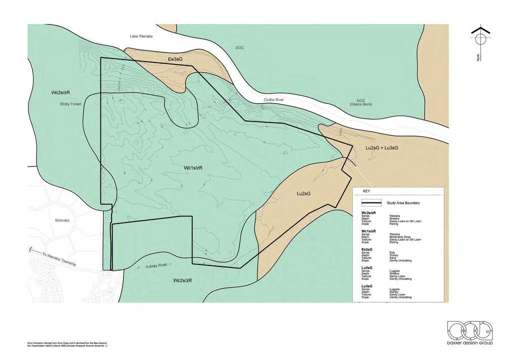
5 the immediate east of the study area and on Mt Iron to the south-east, where it provides a dark overlay in contrast to the light and golden grass covered mountain slopes of the greater landscape. The greatest concentration of Kanuka regeneration occurs on the steepest north facing flanks of the study area where the grade is approximately 1 in 1.5. Grazing and the resulting pastoral grass cover, occurs on the flatter areas that slope from the highest point in the north-west corner down towards Aubrey Road. The first existing mature conifer shelterbelt runs through the study area in a gentle curve for approximately 750 metres. The second shelterbelt is located on the western boundary of the study area from the intersection with Aubrey Road and runs for approximately 840m along this boundary. Photo 7: looking north east over the rolling gentle slopes. VI. Rolling tableland Three areas of the study area display this characteristic. They are located in the south western corner adjacent to Aubrey Road, and on the northern edge between Outlet Road and the steep rolling land which drops down to the river. The landform is a somewhat gentle undulating form without the distinctive grain or high points of the hummock land forms. The Sticky Forest plantation of evergreen conifers to the immediate west of the study area is homogenous and exotic and does not provide any habitat for indigenous fauna. Generally the study area and surrounding land has minimal indigenous ecology due to current and past land management, and a prevalence of monocultural plant cover. VII. Steep Rolling land This characteristic landform is immediately adjacent to the Clutha River and displays a rolling landform with a steep escarpment down to the water s edge. A.2.5 Soils The glacial formation and complex nature of the study area and surrounds has resulted in four major soil series: Moderately deep Wanaka sandy loam on silt loam over most of the study area (refer Figure E) Shallow Luggate sandy loam and shallow in the eastern edge of the study area where the flats and gullies occur. Shallow Wanaka sandy loam on silt loam in the north-west corner over the steepest river terraces. Stoney Eely sand at the base of the steep river terrace in the north-west corner of the study area. Photo 8: looking east from the major hummocks towards a stand of regenerating Kanuka and a single conifer. A.2.6 Ecology The undulating landform and soils on the study area would have originally provided a series of ecological niches from wetter, low lying areas between hummocks to exposed, open, elevated areas subject to the desiccating effects of high winds and sun. The existing study area ecology has been greatly reduced by past farming of the study area and the removal of most if not all indigenous vegetation and accompanying fauna. The indigenous vegetation on the study area and surrounding land comprises regenerating Kanuka shrubland, generally in stands on the steeper north facing escarpment, and north facing gullies, and higher and drier tops of some hummocks. Grey shrubland and tussocks occur in low lying wetter areas in the south west corner of the study area. The indigenous vegetation is not extensive over the study area, and its occurrence is possibly a result of land management techniques, rather than the desire to maintain indigenous plant cover. Kanuka shrubland is more extensive over the D.o.C managed Hikuwai Reserve to Photo 9: looking west towards the major hummocks showing the isolated pockets of regenerating Kanuka. Despite the small and somewhat fragmented indigenous plant cover, it has been recognized by the ecologist that some of the areas identified on the plan (refer Figure F) are worth protecting to allow further regeneration. The areas identified correspond with the north facing escarpment and low lying areas in the south west of the study area. The Kanuka on the north facing escarpments particularly, provide a continuous vegetation cover and pattern, and a natural character to the edge of Lake Wanaka. J:\ Winton, East Wanaka PC\Section 32 assessment\1788 Section 32 Landscape report A3 6 March FINAL.doc 5
6 From lake views, to the north of the study area, in the vicinity of the Mount Burke homestead and parts of Dublin Bay, the western boundary of the study area is demarcated by a fire break between the study area and the Sticky Forest plantation. The boundaries of the remainder of the study area visible from this point are not demarcated due to the natural pattern of mixed vegetation along the river edge and within the northern part of the study area. The pattern of the vegetation is a mixture of regenerating Kanuka, wilding conifers and exotic willows on the waters edge. Open areas of pastoral grass are small and intermittent and form part of the mosaic of vegetation cover. They are visible from the Clutha River as the viewer travels further down the river. They are not visible from the lake. The natural character of the landscape is contiguous from the ridgeline down to the waters edge and east along the landform. The natural character also continues to the west, with the exception of the intrusion of the Sticky Forest conifer plantation. The study areas current ecological state and potential for improvement has been discussed in the separate report prepared by Andrew Penniket, Restoration Consultants. It has identified the areas to be protected to allow for further regeneration and improvement in species diversity. The majority of the areas to be protected are the areas of regenerating Kanuka on the north facing escarpments of the study area. There are also 3 blocks of significant size in the south west portion of the study area. A.2.7 Hydrology The study area does not contain any permanent water sources or course. Hydrology has shaped the grain of the study area by eroding the softer soils between the hummocks and cutting down the faces of the fluvial terraces. J:\ Winton, East Wanaka PC\Section 32 assessment\1788 Section 32 Landscape report A3 6 March FINAL.doc 6


7 B: LANDSCAPE ANALYSIS B.1 LAND USE The wider environment exhibits a variety of land uses, and is largely a mixture of urban, semi-rural and rural landscapes. This includes the townships of Wanaka and Albert Town. Land uses include business, residential of varying densities, visitor accommodation and entertainment, commercial use and light industrial use. These uses are largely concentrated on the lake front for approximately 2km inland between Roys Bay and Beacon Point, along the Clutha River in the vicinity of the Hawea River, and along the arterial and local roads of the Cardrona Valley Road, Riverbank Road and the Wanaka-Luggate Highway. Semi-rural lifestyle blocks and rural land is located between the urban edge and the Cardona River as far as the entrance to the Cardrona Valley and north of residential development on Aubrey Road to Mt Brown and beyond. Photo 10. North Wanaka residential block. Taken from Kirimoko Crescent looking south west towards residential development above Eely Point. The open pastoral land in the foreground is the zoned, but as yet undeveloped, Kirimoko subdivision (Low Density Residential Zone) Within that wider environment is the wedge. For the purposes of this report, the wedge includes the land from Beacon Point east to the toe of Mt Iron, north to the Clutha River and south to the Wanaka Luggate highway. The study area sits within the wedge. B.1.1 The Wedge - Context The current land use of the wedge is mixed. It contains the following zoning: Rural General Rural Residential Residential Penrith Park Zone Township Zone (Albert town) Low density residential zone Open space zone. Business Zone (Anderson Road) The wedge displays a mix of rural, residential, recreational and open space uses which reflecting the underlying zoning. The wedge can be broadly broken down into four blocks: Northern Wanaka residential. The area from Beacon Point and Bremner Bay around to the western toe of Mt Iron is predominantly a low density residential zone with an established residential character close to the lake and Wanaka township. The character is not consistent across the residential area, as new subdivisions are being developed on the more elevated slopes. The topography generally slopes towards the lake allowing views over the lake and mountains. Photo 11: Taken from Kirimoko Crescent looking west towards residential development above Bremner Bay. The pastoral land in this photo is also zoned for residential development. Albert Town residential. The area at the eastern end of the wedge includes part of the Albert Town township. It also has an established residential character, although it is less urban in appearance than north Wanaka due to Albert Town s past as a holiday area. Aubrey Road Rural lifestyle. Aubrey Road has a largely rural lifestyle character located in the base of the valley between the elevated land of the study area and neighbouring land, and Mt Iron. It is an established landscape with mature gardens and tree planting on large lots (approximately 4000 m2). Houses are generally set back from the road from Peak View Ridge Road east to Rockhaven Road. A lack of fencing and open front lawns adds to the rural lifestyle amenity. The area of Aubrey Road from Peak View Ridge Road west to the low density residential area of Wanaka appears less developed as the Kirimoko subdivision has been consented but not constructed. J:\ Winton, East Wanaka PC\Section 32 assessment\1788 Section 32 Landscape report A3 6 March FINAL.doc 7


8 IV. The Northlake 64 lot rural residential subdivision (RM051067). The development has an average lot size of 4000m2 and at the time of this report the development has been consented but not constructed. V. Public roads in the form of Outlet Road which accesses the Wanaka Outlet camp and a boat ramp on the lake edge. A private access road runs from Peak Ridge Road across the south western corner to a water tank in the adjoining Sticky Forest. Photo 12: taken from Aubrey Road looking south to existing Rural Residential zoned development. The lots are 2000 m m2. Note the open front lawns and lack of fencing. The mixed use of grazing, undeveloped residential development and camping in the study area, has maintained a predominantly rural character including camping study areas and associated buildings, areas of open pastoral paddocks, pastoral grass, regenerating Kanuka, grey shrubland, tussock, and conifer shelterbelts, within a larger mixed character landscape. The easy topography allows for relatively easy access over most of the study area. Rural land. The study area and surrounding properties to the immediate west and east are both rural. The property to the west, known as Sticky Forest, contains a large forestry block of conifers. A firebreak is cut into the boundary between the forest and the study area providing a clean and dramatic change between one vegetation cover and another. The rural land to the east is the D.o.C Hikuwai Reserve. The reserve is a mixture of pastoral grass cover and regenerating Kanuka with no structures. It displays an appearance similar to the northern face of the study area and the boundary between the two is visually seamless for approximately half its length. The area of the wedge with the greatest variation in land use is the Rural General Zone. The RG zone includes the Sticky Forest conifer plantation and is used for farming and occasional grazing, the Wanaka Outlet campground, the Hikuwai Conservation Area administered by D.o.C, and Crown land on the edge of the Clutha River and Lake Wanaka. The Lake Outlet Track is a popular walking track connecting Glendhu Bay campground and the Wanaka Outlet Campground via the waterfront. From the Wanaka Outlet Camp it becomes Hogan s Track to where it ends in Hikuwai Reserve at Aubrey Road. Sticky Forest is also used for mountain biking. The study area, in the wider context of the wedge, is largely surrounded by residential uses, with Lake Wanaka and the Clutha River providing a natural boundary to further town expansion. The landuse over the wedge is mixed and does not display a contiguous landscape character. B.1.2 The study area The following uses occur in the study area: I. Commercial the Wanaka Outlet Camp Study area located in the north-west corner of the study area and accessed from Outlet Road. The camping ground is set within the largest area of regenerating Kanuka at the base of the escarpment in the northwest corner of the study area. It consists of existing buildings, tent study areas, and unsealed tracks branching throughout the study area to the various tent study areas and facilities. The setting of the camp ground within the Kanuka, gives it a largely natural appearance with minor modifications. II. Grazing casual horse and sheep grazing maintain the pastoral appearance over the majority of the study area. III. A former sawmill study area adjacent to Aubrey Road. The mill is redundant and the mill site is currently being analysed for soil contamination. Photo 13: Outlet Road, an unsealed public road crosses the study area from the southern intersection with Aubrey Road to the north-western corner of the study area. A second private access road crosses the south western corner of the study area to access the water tank on neighbouring land. B.2 VISIBILITY Part of the resource gathering involved assessment of the visibility of the study area when viewed from prominent public viewpoints. The principal viewpoints were determined to be the following: Wanaka hinterland Lake Wanaka Clutha River Surrounding public roads J:\ Winton, East Wanaka PC\Section 32 assessment\1788 Section 32 Landscape report A3 6 March FINAL.doc 8


9 B.2.1 Wanaka hinterland The major hummocks are visible intermittently from the area to the south and south east of Wanaka township. From roads such as Ballantyne Road and Riverbank Road the hummocks are seen through gaps in existing trees between the viewer and the study area. Views from these areas are approximately 4km to 7km away. Mt Iron screens views of the lower elevations of the study area from these viewpoints. B.2.2 Lake Wanaka The north facing flank of the wedge landform is visible as a distinct edge from Lake Wanaka and the Clutha River, from the lake between approximately Beacon Point, parts of Stevenson s Arm, the western end of the Dublin Bay Peninsula, and the Clutha River outlet as far as the eastern boundary of the study area. This is an area of approximately 520ha. The detail of the vegetation cover and aspects of the Wanaka Outlet campground become less noticeable as the viewer moves further from the lake edge. Views of the study area are screened by the Dublin Bay peninsula and from Dublin Bay. The interior of grazing land and the glacially formed hummocks are not visible from anywhere on the lake. The northern part of the study area the major escarpment, and fluvial terraces, are highly visible from the lake. B.2.3 Aubrey Road The study area is currently visible when travelling along Aubrey Road in an easterly direction from: I. Approximately Kirimoko Crescent to approximately Peak View Ridge Road. The major hummocks, rolling gentle slopes and part of the minor hummocks are visible. From this point east for approximately 715m the study area is screened by existing residential development and a rising landform. II. III. The study area is then visible again, as the viewer travels along the southern boundary of the study area as far as Outlet Road. Views into the study area become more restricted as residential development within the existing Northlake subdivision is built. Once Northlake subdivision is developed, the major hummocks, and minor hummocks will be visible. When travelling along Aubrey Road in an easterly direction from Outlet Road to the eastern boundary of the study area the study area is partially visible. The existing conifer shelter belt along Outlet Road screens views into the lower elevations of the study area. The edges of the gully can be seen, as can the fluvial terraces/flats and the rolling table land. Photo 14: Approximately 1.5km from lake edge, looking south to study area. Sticky Forest and the fire break between the forest and study area can be seen in the middle of the photo. Photo 16: Taken looking north from Lower Hidden Hills Drive looking north towards consented 64 lot site B.2.4 North side Mt Iron residential neighbourhood Photo 15: taken from Dublin Bay. The Dublin Peninsula screens views to the study area. From the lake, the western boundary of the study area is demarcated by a fire break between the land and the Sticky Forest plantation. The boundaries of the remainder of the land visible from this point are not evident due to the natural pattern of mixed vegetation along the river edge and within the northern part of the study area. That vegetation is a mix of regenerating Kanuka, wilding conifers and willows. From those views open areas of pastoral grass on the study area can be seen and form part of the mosaic of vegetation cover. They are visible from the Clutha River as the viewer travels further downstream. They are not visible from the lake. The natural character of the study area and surrounding landscape is contiguous from the ridgeline down to the waters edge and east along the landform. This character continues to the west, with the exception of the intrusion of the Sticky Forest conifer plantation. B.2.3 Clutha River From the Clutha River views into the study area are screened by the banks of the river and the difference in elevation between the viewer and the landscape. The steeply rolling land, steep sides of the river and additional existing vegetation screen views into the study area. The study area, with the exception of the north facing escarpment and fluvial terraces, is visible from the public roads on Mt Iron. The top of the public roads are approximately the same relative level as the highest point on the study area (approximately 400 masl), hence views over the study area are extensive. Photo 17: From upper Hidden Hills Drive looking north over study area Hillside Road is located on the north western side of Mt Iron, and is elevated above Aubrey Road and looks over the study area. From this point the minor escarpment, rolling table land, minor and major hummocks are visible. The consented Northlake subdivision will be visible in the foreground once it has been constructed. J:\ Winton, East Wanaka PC\Section 32 assessment\1788 Section 32 Landscape report A3 6 March FINAL.doc 9

10 B.2.5 Outlet Road Outlet Road travels through the study area on the fluvial terraces/flats. The existing mature conifer shelter belt on both sides of the road currently screens views into the study area. It is likely that if the shelter belt were removed views would be extensive over the study area and the major and minor hummocks, fluvial terraces/flats, rolling table lands and edge of the gully would be visible. The section of Outlet Road from the northern end of the shelter belt to the northern end of the road at the Wanaka Outlet camp ground travels through open fluvial terraces/flats unobstructed by vegetation. From this section of the road the major escarpment, rolling table land and minor hummocks on the study area can be seen. B.2.6 Dublin Bay Peninsula escarpment Minor escarpment Gully Steep rolling land B.4 LANDSCAPE BOUNDARY Having looked at the Study Area and the wider landscape analysis it becomes clear that the study area falls into 2 different landscapes, being firstly the landscape that flanks Lake Wanaka, and secondly, the landscape containing and flanking the Wanaka urban area. The Lake Wanaka Landscape, recognised as an Outstanding Natural Landscape (ONL) in the District Plan, and confirmed by Environment Court Decisions, includes the lake itself and those areas that frame the lake. This frame includes the escarpments above the motor camp and generally the rim of the lake, where that rim is recognisable as the edge of this landscape. Photo 18: Taken from the point of the Dublin Bay Peninsula looking south towards major escarpment and Outlet campground The north facing escarpment of the study area is visible and open and displays clearly its natural character and continuity with the land to the west. Sticky Forest, the conifer plantation forest, is highly visible and contrasts with the natural vegetation patterns of the remainder of the northern edge of the wedge. The firebreak between the plantation forest and study area is clearly demarcated. B.3 SUMMARY OF VISIBILITY As described in the above section, the widest views into the study area are local, and tend to increase with elevation of the viewer into the land. Views from the hinterland of Wanaka township tend to be intermittent and only of the higher elevations due to the screening effect of Mt Iron. Views from the lake and river to the study area and surrounding landscapes are restricted to the north facing escarpment and fluvial terraces adjacent to the lake. Views from public roads, being Outlet Road and Aubrey Road, to the study area will be largely screened eventually by the consented Northlake subdivision. In the case of public roads on Mt Iron, the hummocks, in particular, at the top of the study area, become more visible as the viewer travels further up the Roche Moutonee. Visible from Wanaka hinterland Lake Wanaka Clutha River Aubrey Road Outlet Road Mt Iron Major Hummocks Minor hummocks Rolling gentle slopes Rolling table land Fluvial terraces Major The rest of the study area is within the wider urban landscape, some developed and some not. There are larger areas of undeveloped land, with a rural character, such as larger parts of the study area, however these are generally not of an appropriate scale to be considered a separate landscape and therefore are included as part of the urban landscape of Wanaka. No landscape category has been determined for the study area. The study area is adjacent to the ONL of Lake Wanaka and as such may or may not be within the ONL categories. The following section of this report analyses and makes a recommendation for the landscape categories of the study area and where the boundary is appropriate if it is found that the study area is within more than one category. The first step in the analysis is the application of the Pigeon Bay Criteria: B.4.1 Pigeon Bay Criteria (a) The natural science factors the geological, topographical, ecological and dynamic components of the landscape; The study area and surrounds demonstrates its glacial formation clearly both in the form of the wedge and its context in the much larger Wanaka basin. It is an elevated landform, with a Roche moutonee, glacial till and lake/river terraces and beaches within a greater glacially formed basin ringed by sharply scoured mountains. The expressiveness of the study area can easily be seen in the corrugated hummocks on the study area, at the toe of Mt Iron, and Mt Iron itself. The pastoral grass cover of part of the study area and surrounds allows clear observation of glacial detail such as the hummocks, terraces and gullies while the regenerating Kanuka covers the detail of the northern face of the study area and the detail of the terraces. The study area s geological formation can also be easily seen and interpreted. Topography J:\ Winton, East Wanaka PC\Section 32 assessment\1788 Section 32 Landscape report A3 6 March FINAL.doc 10
11 The topography of the peninsula landform as a whole is that of a wedge of land that has a crumpled surface where it abuts a Roche moutonee, and then grades in a gently undulating form towards Lake Wanaka and the township. The edge of the wedge runs parallel to the Clutha River and drops sharply to the river on the edge of the study area and more gently so towards the western and eastern ends of the wedge. The topography of the landform as a whole is distinctive because of the hummocks, the presence of Mt Iron and the definition of its edge by the lake, river and Mt Iron. (d) Transient values occasional presence of wildlife; or its values at certain times of the day or year; The study area and surrounding landscape does not demonstrate seasonal or daily transient values due to the partial cover of evergreen vegetation, dwellings and roads. The exception is the edge of Lake Wanaka and the Clutha River where occasional willow trees will express transient values during autumn and winter with the change in leaf colour and then leaf fall. However, the willows trees are in small numbers Ecology (e) Whether the values are shared or recognized; Ecologically the study area and surrounding area have some indigenous vegetation. The ecological variety is limited to regenerating Kanuka, grey shrubland and snow tussocks which provide some habitat for native fauna which occur on the rivers edge, steeper parts above the rivers edge, Hikuwai Conservation Area and Mt Iron. (b) Its aesthetic values including memorability and naturalness; The aesthetic values of the study area including its naturalness are derived from the distinctiveness and complexity of its formation, namely the hummocky forms in the north west of the study area, its form, its location adjacent to Mt Iron and its partial cover of regenerating Kanuka. An observer s experience of the study area is primarily one of rural land adjoining the Wanaka urban area. The Aubrey Road neighbourhood has a lifestyle character, overriding the natural factors and providing a transitional lifestyle area between the high density residential neighbourhoods of Wanaka and the open landscape of the Lake Wanaka. As discussed earlier in this report, that Aubrey Road neighbourhood is subject to ongoing and future change. The significant change is the ongoing development of unutilised sections along the south side of Aubrey Road, and the future development of the 64 Lot subdivision to the north of Aubrey Road, on the southwest corner of the study area (refer earlier report photos 10-13,16,17). This area has a definitive character of larger urban lots, tree planting and the patterns and scale of lifestyle lots. The consented 64 Lot subdivision will impart a similar amenity. In effect this lifestyle character will be continuous along Aubrey Road. Thus the human influence overlaying the wedge is mixed and hides the detail of the geological formation because of trees, particularly the Sticky Forest conifer plantation, regenerating Kanuka, roads and housing. The memorableness of the study area is more to do with the fact that it forms part of the southern arm to the start of Clutha River and is part of the backdrop to Wanaka township rather than any aspect of its form or indigenous or human cover. (c) Its expressiveness (legibility): how obviously the landscape demonstrates the formative processes leading to it; The legibility of the study area, is expressive within the north western part of the study area where the hummocky glacial till forms can be clearly seen. The expressiveness of the greater landform however is minor in that seen in context of the much larger glacial formation of the Wanaka Basin. A viewer would assume the landform is of glacial origin. The expressiveness of the formation of much of the landform is covered by development such as dwellings and roads, the existing areas of regenerating Kanuka, wilding conifers, and the conifer plantation. It is generally shared and recognised by observers that the study area is part of a glacial landform because of its larger association with the glacial formation of the Wanaka Basin and the hummocky forms within the study area. The vegetation cover of regenerating Kanuka creates a contiguous natural character with the north facing landscape on either side of the study area. Therefore its natural character values are recognised as being part of the natural back drop to Lake Wanaka. Within the study area the Aubrey Road urban neighbourhood forms an integral part of that shared value. This valley includes Mount Iron, Aubrey Road and the wider part of that valley experience, extending to the top of the escarpment south of the campground. (f) Its value to tangata whenua; There is no evidence of cultural use or significance of the study area to tangata whenua. The value of the adjacent Lake Wanaka and Clutha River would have been as a major route into the alpine areas. (g) Its historical associations The study area has historical farming associations as has much of the Wanaka area from the 1850s onwards. There are no artifacts indicating settlement of the study area or use other than farming. SUMMARY The northern flanks of the study area landform as assessed above, demonstrate ONL factors that are consistent across the northern face of the study area, and on the northern facing slopes, and fluvial terraces of land to the west and east of the study area. These are the vegetation cover, the vegetation pattern and the topography all of which are consistent across the northern facing slopes of the wider landform. The steepness of the topography of the landform dictates the vegetation pattern in terms of which areas are in pastoral grass, and which areas are somewhat inaccessible and have been recolonised by native Kanuka. The change from the natural character of the Kanuka cover to the pastoral character of grazed pastoral grass occurs at the ridgeline between the steep, north facing escarpments of the study area and the gentler south facing slopes. Coincidentally these two parts of the study area are also experienced in different visual catchments which also have different landscape characters. The north facing escarpments clothed with Kanuka are seen as part of, and while on, Lake Wanaka and the northern side of the Clutha River. The pastoral, south facing flanks are seen as part of the Wanaka urban area, as part of the Aubrey Road neighbourhood which has a lifestyle character. In summary there are four factors which guide the location of a landscape boundary: J:\ Winton, East Wanaka PC\Section 32 assessment\1788 Section 32 Landscape report A3 6 March FINAL.doc 11
12 Topography. The topography of the larger landform that the site is a part of, is shaped crudely like a wedge, with the steepest side forming the southern edge to Lake Wanaka and the gentler side sloping down towards the plains of the Wanaka Basin. The change between the slopes is a clear ridgeline. Vegetation cover. The vegetation cover on both sides of the ridgeline is different. The steep north facing flank of the study area is clothed in kanuka, while the southern facing slopes which are characterised largely by pastoral grass cover and two large conifer shelterbelts. The vegetation pattern is largely determined by the grade of the topography. The steeper faces which are generally inaccessible are clothed in kanuka, while the south facing slopes which are accessible to stock and farm vehicles are grazed. Visual catchments. The north facing flanks of the study area are seen when on Lake Wanaka, or on the land at the edge of the lake. The lake is an ONL. The south facing slopes are seen when in the Aubrey Road neighbourhood as part of the lifestyle landscape of this area. Therefore, the most appropriate location for the ONL boundary is at the ridgeline between the steep north facing escarpment with a natural character and the south facing gentler slopes with a pastoral character. The proposed boundary is shown on Figure I. B.5 LANDFORM UNITS The study area was found to contain 9 distinctive landscape units, based on the topographical characteristics. These included major escarpments, steep rolling land, hummocks, minor escarpments, fluvial terraces, fluvial terraces/flats, gullies, gentle rolling slopes, and rolling table lands Figure C shows the location of the landform units identified. The landform units, that describes the land within the ONL, can be described as the Major Escarpments, the Steep Rolling Land and the Fluvial Terraces (refer Figure C) The landform units considered to be inappropriate for residential development would include those above and set out below (landform units 1-3): Unit 1: The Major Escarpments Major escarpment Geology Steeply tilted fluvial terraces Ecology Reasonably continuous cover of regenerating Kanuka Occasional outcrops of mature, wilding conifers Visibility Highly visible from Lake Wanaka, the Clutha River and Outlet Road Not visible from Aubrey road and Mt Iron Roads Partially visible from Outlet road Existing land uses Regenerating Kanuka Potential to absorb change Low potential. Steep - 1 to 1.5 grade and within recommended ONL Landscape management Manage to maintain and enhance cover of Kanuka and promote species diversity Public access and recreation Little potential for public access due to steepness of slope Unit 2: Steep rolling land Steep rolling land Geology Glacial till and fluvial erosion from river. Ecology Regenerating Kanuka. Block of wilding pines. Visibility Low visibility. Seen from Outlet Road and Mt Iron residential neighbourhood. Existing land uses Some pastoral grazing Potential to absorb change Low due to recommended ONL. Landscape management Retain Kanuka. Public access and recreation Hogan s Track runs through. Potential to connect back into study area. Unit 3: Fluvial Terrace Steep rolling land Geology Larger terrace flanking the lake at base of major escarpment Ecology Regenerating Kanuka. Minor blocks of wilding pines. Visibility Highly visible from Lake and lakeside walkway. Existing land uses Wanaka Outlet Campground Potential to absorb change Existing campground use considered appropriate Landscape management Maintain existing use and retention of Kanuka as character Public access and recreation Access to lakeside reserve for passive recreation and boat launching, riverside walkway/cycleway, campground. Following on from above the landforms considered to be appropriate for residential development would include those below (landform units 4-9): Unit4: Hummocks Characteristics Geology Complex geomorphology. Glacial till has been eroded by ephemeral streams to form a north west south east grain Ecology Small isolated areas of regenerating Kanuka generally located on sides of hummocks Predominantly improved pasture Visibility Partially seen from Wanaka hinterland, residential neighbourhood on Mt Iron, Aubrey road. Not seen from Lake Wanaka or the Clutha River. Existing land uses Pastoral grazing J:\ Winton, East Wanaka PC\Section 32 assessment\1788 Section 32 Landscape report A3 6 March FINAL.doc 12
13 Potential to absorb change Medium potential in minor hummocks. Low potential in major hummocks. Landscape management Manage to maintain prominence of landforms where most complex and distinctive Public access and recreation Potential for passive recreation and access between hummocks to maintain integrity of landforms Unit 5: Minor escarpment Minor escarpment Geology Tilted fluvial terrace Ecology Pastoral grass and wilding conifers Visibility Highly visible from Aubrey Road and Mt Iron residential neighbourhood Existing land uses Consented but not yet developed rural residential subdivision Potential to absorb change High Landscape management None proposed Public access and recreation Already established in consent subdivision layout Unit 6: Fluvial terraces/flats Fluvial terraces Geology Elongated terraces flanking the sides of lake, and around base of elevated glacial landform Ecology Predominantly improved pasture. Isolated areas of regenerating Kanuka Occasional outcrops of mature, wilding conifers Willows along waters edge Visibility Highly visible from Lake Wanaka, the Clutha River and Outlet Road where adjacent to river Medium visibility from Aubrey road and Mt Iron Roads Existing land uses Wanaka Outlet camping ground Boat ramp Passive recreation (Lake outlet track and Hogan s track) Pastoral grazing Potential to absorb change Low potential where recommended ONL and proximity to lake and river on northern edge of study area High potential adjacent to Aubrey road and Outlet Road as far as ONL Landscape management Manage to maintain and enhance cover of Kanuka where existing and promote species diversity on northern edge. Potential for residential development. Public access and recreation Potential to connect to existing recreation opportunities on lake and river edge Unit 7: Gully Gully Geology Fluvial terraces been eroded by ephemeral streams Ecology Areas of regenerating Kanuka at northern end. Predominantly improved pasture Visibility Low visibility. Partially seen from Aubrey Road and Mt Iron residential neighbourhood. Not seen from Lake Wanaka or the Clutha River. Existing land uses Pastoral grazing Potential to absorb change Low potential due to narrowness and steepness of sides of gully Landscape management Manage to maintain and enhance cover of Kanuka and promote species diversity Public access and recreation Potential for passive recreation and connections to recreation beyond study area, particularly river edge. Unit 8 Rolling gentle slopes Rolling gentle slopes Geology Glacial till Ecology Predominantly improved pasture Three significant areas of grey shrubland/tussock. Visibility Low visibility. Screened by existing Aubrey road development. Visible from Mt Iron residential neighbourhood. Existing land uses Pastoral grazing. Potential to absorb change High potential. Topography gently sloped, minimal visibility. Landscape management Retain significant grey shrubland/tussock Potential for residential development. Public access and recreation Potential for passive recreation and connection into Sticky forest. Unit 9: Rolling table land Rolling table land Geology Glacial till Ecology Predominantly improved pasture Two minor blocks of Kanuka. Area of wilding pines Visibility Low. Partially seen from Aubrey Road and Mt Iron residential neighbourhood. Not seen from Lake Wanaka or Clutha River. Existing land uses Partially consented for rural residential development Potential to absorb change High potential. Partially consented for residential development, and low visibility. Landscape management Potential for residential development. Public access and recreation Potential to connect from Aubrey road into larger study area. J:\ Winton, East Wanaka PC\Section 32 assessment\1788 Section 32 Landscape report A3 6 March FINAL.doc 13
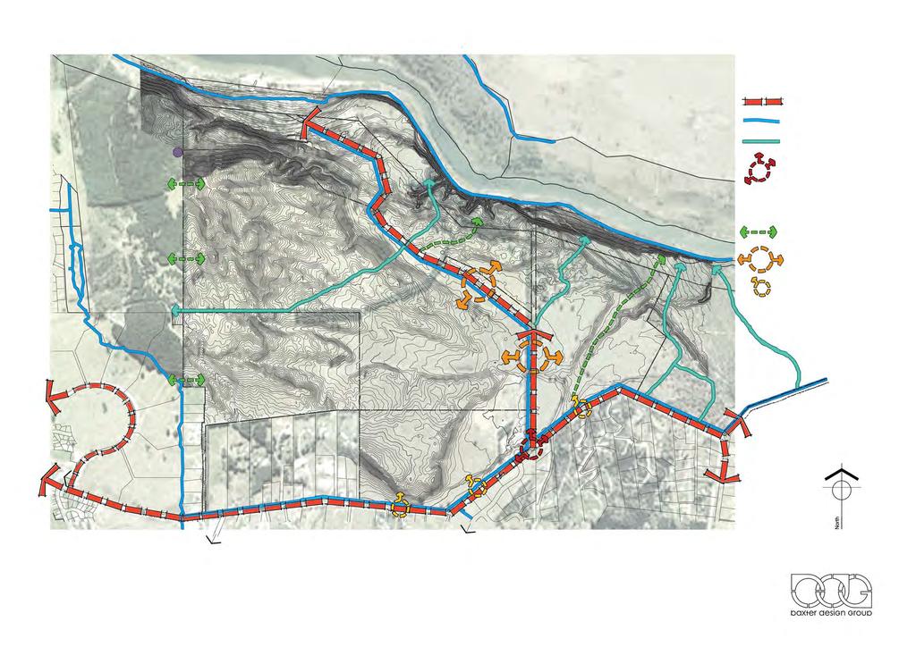
14 The remainder of this report assesses the part of the study area considered appropriate for rezoning for residential purposes (referred to as the site ) of the study area and identified in this report. It enables appropriate forms of development on the site that reflect and respect the landscape qualities of the site. B.6 LANDUSE AND LANDSCAPE MANAGEMENT STRATEGY Figure L shows the proposed structure plan showing the Zone boundary, activity areas, potential walkway / cycleway links, major and secondary road entries and building restriction zones. Key assessment considerations in developing the structure plan have been: ( a) The activity areas providing for residential use show retention of the Aubrey Road lifestyle character along Aubrey Road in response to that existing amenity. (b) (c) (d) (e) (f) (g) (h) (k) (l) The ability for a higher residential density in activity area C in the lower altitudes of the study area, where development is less visible and screened from Aubrey Road by existing and consented residential development. Protection of the areas of regenerating Kanuka Protection of the distinctive hummock landforms of the study area, particularly in the north west corner where they are most defined The creation of a strong pattern of open space at the upper altitudes protects the more sensitive areas of the study area, particularly in views towards the site from existing residential areas on the northern flank of Mount Iron and from other more distant views from the south. Residential development located in areas with the most potential to absorb change. A definitive response to the changing landforms within the area to be rezoned, with lot sizes that differ and respect altitude, visibility and landform. In general the lot sizes increase with altitude, to a point where building restriction areas within the proposed C1 Activity Area are included to allow for the upper visible portions of the landscape to remain substantially as open space. The retention and enhancement of public access through the study area from Aubrey Road to the lakefront and Sticky Forest. Continuing the existing rural and lifestyle edge adjacent to Aubrey Road and Hikuwai Conservation Area SUMMARY: The Structure Plan is considered to be an appropriate response and guide to future residential development on the site. The Structure Plan reflects the landform patterns and landscape characteristics J:\ Winton, East Wanaka PC\Section 32 assessment\1788 Section 32 Landscape report A3 6 March FINAL.doc 14
15
16
17
18
19
20
21
22
23
24
25
26
27 Addendum in response to request for further information J:\ Winton, East Wanaka PC\council RFI's etc\rfi 28 March 2013 response\1788 Northlake - response to RFI - 14 May 2013.doc - 5 -

28 Request For Additional Information Private Plan Change May Introduction This report responds to further information requested from a landscape perspective as per Private Plan Change 45 Request for Additional Information dated 26 March Additional information requested Additional information requested from a landscape perspective is as follows: Visibility of built form from within the ONL to the north of the site north of and including the river. Visual assessment of the effects on the landscape as viewed from the northern side of the river. A determination of the landscape classification(s) for the area proposed to be rezoned. A plan superimposing the boundary between ONL and the rest of the site on a topographical plan. An explanation on how the development will respond to the interface of the Hikuwai Conservation Area. 3. Attachments Figure 1 Figure 2 Figures 3-5 Northlake Structure Plan topographical information, ONL Zone boundary, Northlake Structure Plan location of viewpoints and sightlines. Photographs from viewpoints between the northern boundary of the site and the river and the northern side of the river. 4. Visibility of built form from within the ONL to the north of the site and including the river. Views of the site are mostly limited. A few potential dwellings located in the northwest corner of Activity Area C2 (C2) will be partially visible from locations shown in attached Figure 2. Potential dwellings located across the rest of the site would not be visible from any location north of the site. Views 1 and 2 in Figure 3 are from C2 at 325masl. Views north north-west are of grassed hummocky land and wilding pines in the foreground sloping down to mature pines on the lower ridgeline. View 1 includes the mid section of the Outlet Road just before it drops steeply towards the campground entrance (refer View 4). In the background of both views, the ridge line of the northern river banks is visible. These views give an J:\ Winton, East Wanaka PC\council RFI's etc\rfi 28 March 2013 response\1788 Northlake - response to RFI - 14 May 2013.doc - 1 -
29 indication of the few scattered locations on the northern slopes, where C2 might be visible and not screened by vegetation or by the elevation alone. These locations are the small grassed pockets to the centre and centre left of View 1. Views 3 8 attached in Figures 3 and 4 are from within the ONL boundary, between the northern boundary of the site, and the river. View 3 is from an open paddock just off the Outlet Road, 320 masl, 5m lower than the northwest corner C2. Views south (towards C2) are of grassed paddock in the foreground, rising to small hummocks and gullies planted in pine and kanuka and mature pines in the background. A few potential dwellings would be visible in the background. View 4 is from the Outlet Road at the entrance to the camping ground, 308 masl, 17m lower than the northwest corner of C2. Views to the south south-east are of the camp ground environs in the foreground, the Outlet Road kanuka and pines in the background, approximately 12m higher. The site is completely screened at this point; no potential dwellings would be visible from this location. View 5 is from within the campground at the intersection of the Patiki Loop track, 306masl. Views are of the campground sites and associated vegetation in the foreground, kanuka and pines on the slopes up to the terrace in the background. The tops of pines just in view in the background, line the Outlet Road. The site is completely screened at this point; no potential dwellings would be visible from this location. View 6 is from the south river s edge at the mouth of the river, 285masl. Views are of willows, the river bank and glimpses of the Outlet Track in the foreground. Views behind this are of the lower terrace above the Outlet track, kanuka and a mix of exotic vegetation. In the background the visible ridge planted in kanuka, approximately 300masl, sits in front of the ridge that screens the site. The site is completely screened at this point; no potential dwellings would be visible from this location. View 7 is from the outlet track at the first bend in the river, 270masl. Views are of poplars and pines on the river slopes. The site is completely screened at this point; no potential dwellings would be visible from this location. View 8 is from the Outlet Track, 296masl. Views are of immediate vegetation only. The site is completely screened at this point; no potential dwellings will be visible from this location. 5. Visual assessment of the effects on the landscape as viewed from the northern side of the river. Views of the site are mostly limited. Partial views of a few potential dwellings in the northwest corner of C2 will be glimpsed from locations shown in attached Figure 1. Potential dwellings located across the rest of the site would not be visible from any location north of the site. Views 9-17 attached in Figures 4 and 5, are all from the northern side of the river. View 9 is from the cycle track on the north side of the river, 305masl. Views are of the river, poplars and kanuka on the south river bank and glimpses of the Outlet Track; then of kanuka and wilding pines behind this on the lower slopes. Towards the centre of the view there is an open grassed area this is lower than and in front of the C2. In the background there are distant views of kanuka and pines on the upper terrace; this is in front of and lower than the site. The site is completely screened at this point; no potential dwellings would be visible from this location. J:\ Winton, East Wanaka PC\council RFI's etc\rfi 28 March 2013 response\1788 Northlake - response to RFI - 14 May 2013.doc - 2 -
30 Views are from the north bank of the river, at approximately 280masl. From this low elevation, views are of the river, mature poplars and kanuka on the riverbank and glimpses of the Outlet Track in the foreground, and grassed areas of the top of the lower slopes in the background. The extent of these views is the top of the lower slopes above the river bank, approximately 300masl. The extent of these views is 25m lower than the site. The site is completely screened at this point; no potential dwellings would be visible from this location. The tops of mature pines in the very background of Views 11 and 12 are lower than and in front of the C2. The site is completely screened at this point; no potential dwellings would be visible from this location. Views 13 and 14 are from the north bank of the river, above the cycling track somewhere between masl. Views are of scrubby mixed vegetation and kanuka in the foreground, the campsite and kanuka scattered across the lower southern slopes in the background, with mature pines at the rear. C2 is visible centre left, in front of dense mature pines. Partial views of a few potential dwellings will be visible from these views. View 15 is from the northern river s edge at 275masl. Views are of the river, poplars and kanuka on the lower slopes of the southern river bank and glimpses of the Outlet Track. The tops of the pines and kanuka in the background centre left are lower than and in front of the site. The site is completely screened at this point; no potential dwellings would be visible from this location. View 16 is from the from the northern river s edge at 275masl, northwest of view 15 at the mouth of the river. Views are of the river s edge and river in the foreground, then poplars kanuka and partial views of campground buildings on the southern slopes. In the background centre left of the view are dense mature pines and kanuka with very small patches of grassland visible. The site is just visible in the distance; partial views of a few potential dwellings may be visible from this view. View 17 is from the northern river access track, north of the river mouth. Views are of mixed vegetation in the foreground, the lake / river mouth, and in the background the pine plantation border, kanuka and pines across the northern slopes. The site is barely visible centre left. 6. Visual Summary A few dwellings in the northwest corner of C2 will be partially visible from some locations; these locations are indicated on Figure 2 No parts of any potential dwellings are visible from the north or south shore of the river, or the river itself. Views from the river will not alter as a result of the proposed development. No parts of any potential dwellings would be visible from the camp ground or the Outlet Track car parking areas. Generally the proposed built areas within the visible part of C2 are in gullies and low lying areas and would be partially screened from view. Their visual impact would be mitigated through having a maximum roof height of 5m, or 6m if sloping. Given the limited views of the site, the proposed mitigation measures and the existing visual effects of the campsite on the northern slopes of river; the visual impact of the proposed dwellings on the wider landscape viewed from the north is considered to be less than minor. 7. Determination of the landscape classification(s) for the area proposed to be rezoned. The issue has already been addressed refer Section B.4 Landscape Boundary on pages of the landscape Assessment lodged with the Plan Change Request. Part of the study area lies within the Lake J:\ Winton, East Wanaka PC\council RFI's etc\rfi 28 March 2013 response\1788 Northlake - response to RFI - 14 May 2013.doc - 3 -

31 Wanaka ONL and the balance sits adjacent to that ONL, and is surrounded by the wider Wanaka urban area. If the balance land required a landscape category then, in the absence of the surrounding rural lifestyle / urban areas, the balance land would more than likely carry a VAL landscape category. Given however the scale of the study area remaining outside the Lake Wanaka ONL line, and the urban nature of the surrounding environs, the reasonable approach to the south of the ONL line would be to categorise that land as an ORL. 8. A plan superimposing the boundary between ONL and the rest of the site on a topographical plan. This is attached as Figure An explanation on how the development will respond to the interface of the Hikuwai Conservation Area. The eastern end of the side is bounded with the Hikuwai Conservation Area, the location of this boundary is indicted in the photograph below, the reserve in the foreground and the site behind the red line. The reserve consists of scattered and clustered regenerating Kanuka. The established character of the reserve will be retained and reinforced through the design of the structure plan; development will visually integrate with the Hikuwai Conservation Area. The interface with the boundary will be softened through larger lot size and lower density towards the boundary. If further control was considered necessary, assessment matters relating to fencing types adjacent to the reserve and native planting could be incorporated in order to enable the transition from reserve to residential character to be relatively seamless. Aerial view of site boundary with Hikuwai Conservation Area. J:\ Winton, East Wanaka PC\council RFI's etc\rfi 28 March 2013 response\1788 Northlake - response to RFI - 14 May 2013.doc - 4 -
VISUAL Impact Assessment
 5.0 Existing Landscape Character TO GOULBURN FEDERAL HIGHWAY 5.1 Landscape Character Units Generally one of the first steps in carrying out a landscape and visual assessment is to identify and map the
Significant Natural Area Assessment. Property Name: Hillend Station
 Private Bag 50072, Queenstown 9348, New Zealand QUEENSTOWN, 10 Gorge Road, Phone +64 3 441 0499, Fax +64 3 450 2223 WANAKA, 47 Ardmore Street, Phone +64 3 443 0024, Fax +64 3 450 2223 Significant Natural
Wanaka Community Board 15 April Report for Agenda Item: 4
 Wanaka Community Board 15 April 2015 Department: Infrastructure Report for Agenda Item: 4 Mt Burke Station Stopping and Vesting of Road Purpose 1 To obtain the Board s support for a stakeholder agreement
1.1.1 Landscape character This is the upper part of a bowl-shaped landform, extending east from the Rothiemurchus character area, contained by the
 1.1 Glen More 1.1.1 Landscape character This is the upper part of a bowl-shaped landform, extending east from the Rothiemurchus character area, contained by the arc of the high granite pluton of the Cairngorms
ATTACHMENTS : LANDSCAPE MAPS AND PHOTO ESSAY
 DRURY STRUCTURE PLAN : BACKGROUND INVESTIGATIONS AND VISUAL ASSESSMENT ATTACHMENTS : MAPS AND PHOTO ESSAY Opus International Consultants Ltd Landscape Architecture and Urban Design Level 3 The Westhaven
Geoscape Toronto The Oak Ridges Moraine Activity 2 - Page 1 of 10 Information Bulletin
 About 13,000 years ago as the Laurentide Ice Sheet melted, glacial meltwater accumulated between the ice sheet and the Niagara Escarpment. This formed a lake basin into which gravel and sand were deposited.
2.0 Physical Characteristics
 _ 2.0 Physical Characteristics 2.1 Existing Land Use for the Project The site is comprised of approximately 114 acres bounded by Highway 101 to the north, the existing town of Los Alamos to the east, State
1 INFORMATION REQUIREMENTS
 1 INFORMATION REQUIREMENTS 1.1 BACKGROUND 2 1.2 WHAT IS THE DISTRICT PLAN 3 1.3 DISTRICT PLAN STRUCTURE 4 1.4 HOW TO USE THE DISTRICT PLAN 5 1.5 STRATEGIC FRAMEWORK 6 Whanganui District Plan (15 January
Alpine Glacial Features along the Chimney Pond Trail, Baxter State Park, Maine
 Maine Geologic Facts and Localities September, 2009 Alpine Glacial Features along the Chimney Pond Trail, Baxter State Park, Maine 45 54 57.98 N, 68 54 41.48 W Text by Robert A. Johnston, Department of
Northland Regional Landscape Assessment Worksheet
 Northland Regional Landscape Assessment Worksheet DESCRIPTION AND CHARACTERISATION Component Land Types Northern and eastern dissected ranges; high relief land type Unit name MT TIGER BUSH AND REMNANTS
MIDDLE SCHOOL CURRICULUM TR AILING ICE AGE M YST ERI E S SEARCHING GLACIAL FEATURES
 MIDDLE SCHOOL CURRICULUM TR AILING ICE AGE M YST ERI E S SEARCHING GLACIAL FEATURES CONTENTS I. Enduring Knowledge... 3 II. Teacher Background... 3 III. Before Viewing the Video... 5 IV. Viewing Guide...
glacier Little Ice Age continental glacier valley glacier ice cap glaciation firn glacial ice plastic flow basal slip Chapter 14
 Little Ice Age glacier valley glacier continental glacier ice cap glaciation firn glacial ice plastic flow basal slip glacial budget zone of accumulation zone of wastage glacial surge abrasion glacial
1 Glacial Erosion and
 www.ck12.org Chapter 1. Glacial Erosion and Deposition CHAPTER 1 Glacial Erosion and Deposition Lesson Objectives Discuss the different erosional features formed by alpine glaciers. Describe the processes
Wicklow Mountains Path Survey
 Wicklow Mountains Path Survey Glenmacnass Tonelagee Start to Finish: O 114 030 to O 085 016 Altitude (lowest highest): 370m 817m Weather: Sunny day, hot Access: Military Road, Glenmacnass Surveyed by:
Glaciers. Glacier Dynamics. Glacier Dynamics. Glaciers and Glaciation. Types of Glaciers. Chapter 15
 Chapter 15 Glaciers and Glaciation Glaciers A glacier is a large, permanent (nonseasonal) mass of ice that is formed on land and moves under the force of gravity. Glaciers may form anywhere that snow accumulation
Glaciers Earth 9th Edition Chapter 18 Mass wasting: summary in haiku form Glaciers Glaciers Glaciers Glaciers Formation of glacial ice
 1 2 3 4 5 6 7 8 9 10 11 12 13 14 15 Earth 9 th Edition Chapter 18 Mass wasting: summary in haiku form Ten thousand years thence big glaciers began to melt - called "global warming." are parts of two basic
AMENDMENT NO. 03 TO THE OFFICIAL PLAN FOR THE TOWNSHIP OF ADJALA-TOSORONTIO OAK RIDGES MORAINE CONSERVATION PLAN
 AMENDMENT NO. 03 TO THE OFFICIAL PLAN FOR THE TOWNSHIP OF ADJALA-TOSORONTIO OAK RIDGES MORAINE CONSERVATION PLAN Adopted by Council July 19 th, 2004 Approved with modifications by the Province of Ontario
Glaciers and Glaciation Earth - Chapter 18 Stan Hatfield Southwestern Illinois College
 Glaciers and Glaciation Earth - Chapter 18 Stan Hatfield Southwestern Illinois College Glaciers Glaciers are parts of two basic cycles: 1. Hydrologic cycle 2. Rock cycle A glacier is a thick mass of ice
GLACIER STUDIES OF THE McCALL GLACIER, ALASKA
 GLACIER STUDIES OF THE McCALL GLACIER, ALASKA T John E. Sater* HE McCall Glacier is a long thin body of ice shaped roughly like a crescent. Its overall length is approximately 8 km. and its average width
GLACIATION. The Last Ice Age (see Chapter 12) and. Pleistocene Ice Cap. Glacial Dynamics 10/2/2012. Laurentide Ice Sheet over NYS
 and. Pleistocene Ice Cap. Glacial Dynamics 10/2/2012. Laurentide Ice Sheet over NYS") GLACIATION and New York State Prof. Anthony Grande The Last Ice Age (see Chapter 1) The Pleistocene Epoch began 1.6 mya. During this time, climates grew colder. There were numerous ice ages starting 100,000000
GLACIATION and New York State Prof. Anthony Grande The Last Ice Age (see Chapter 1) The Pleistocene Epoch began 1.6 mya. During this time, climates grew colder. There were numerous ice ages starting 100,000000
Visual and Sensory Aspect
 Updated All Wales LANDMAP Statistics 2017 Visual and Sensory Aspect Final Report for Natural Resources Wales February 2018 Tel: 029 2043 7841 Email: sw@whiteconsultants.co.uk Web: www.whiteconsultants.co.uk
Proposed Peninsula Bay Bike Track Development
 Proposed Peninsula Bay Bike Track Development May 2018 BACKGROUND The area of land at the northern extreme of Wanaka's Peninsula Bay development (Lot 923 DP 501325), currently owned by Infinity Investment
MIDDLE SCHOOL CURRICULUM TR AILING ICE AGE M YST ERI E S ICE AGE TREKKING
 MIDDLE SCHOOL CURRICULUM TR AILING ICE AGE M YST ERI E S ICE AGE TREKKING CONTENTS I. Enduring Knowledge... 3 II. Teacher Background... 3 III. Before Viewing this Video... 5 IV. Viewing Guide... 5 V. Discussion
Chapter 16 Glaciers and Glaciations
 Chapter 16 Glaciers and Glaciations Name: Page 419-454 (2nd Ed.) ; Page 406-439 (1st Ed.) Part A: Anticipation Guide: Please read through these statements before reading and mark them as true or false.
CRAZY HORSE TRAIL GUIDE
 CRAZY HORSE TRAIL GUIDE Abridged Version: July 2016 This is a short form of our interpretive trail guide for the Crazy Horse Trail. The full version of the guide has a more detailed description of the
2.0 PARK VISION AND ROLES
 2.0 PARK VISION AND ROLES 2.1 Significance in the Protected Area System Marble Range and Edge Hills provincial parks protect 6.8% of the Pavillion Ranges Ecosection, which is located in the Southern Interior
Terrestrial Protected Area Nomination: Central Mangrove Wetland South-West, Grand Cayman
 Terrestrial Protected Area Nomination: Central Mangrove Wetland South-West, Grand Cayman The attached nomination, proposing that a parcel of land in the Central Mangrove Wetland be made a Protected Area
Glacial Geomorphology Exercise
 James Madison University Field Course in western Ireland Glacial Geomorphology Exercise 3-day road log (abbreviated) Striations Large kame terrace Cirque with moraines Kame delta Striations Eskers Raised
Trail Phasing Plan. Note: Trails in the Clear Creek Canyon area (Segments will be finalized in the future to minimize wildlife impacts
 Note: Trails in the Clear Creek Canyon area (Segments 2 5 and a future JCOS connection) will be finalized in the future to minimize wildlife impacts Trail Phasing Plan P Parking 3 Easy Trail Intermediate
47I THE LAS ANIMAS GLACIER.
 THE LAS ANIMAS GLACIER. ONE of the largest of the extinct glaciers of the Rocky Mountains was that which occupied the valley of the Las Animas river. This stream originates in the San Juan mountains in
Glaciers. Clicker Question. Glaciers and Glaciation. How familiar are you with glaciers? West Greenland. Types of Glaciers.
 Chapter 21 Glaciers A glacier is a large, permanent (nonseasonal) mass of ice that is formed on land and moves under the force of gravity. Glaciers may form anywhere that snow accumulation exceeds seasonal
Geologic Trips, Sierra Nevada
 ISBN 0-9661316-5-7 GeoPress Excerpt from Geologic Trips, Sierra Nevada by Ted Konigsmark All rights reserved. No part of this book may be reproduced without written permission, except for critical articles
I507 Devonport Naval Base Precinct
 I507. Devonport Naval Base I507.1. Precinct Description The Devonport Naval Base precinct covers most of the land held by the Crown for the HMNZ Naval Base (south yard) in Devonport. It incorporates the
Specification for Grip blocking using Peat Dams
 Technical Guidance Note 1 Specification for Grip blocking using Peat Dams 1. Introduction Moorland drains (grips) have been dug across much of the Yorkshire upland peatlands. Many of these grips have become
READING QUESTIONS: Glaciers GEOL /WI 60 pts. a. Alpine Ice from larger ice masses flowing through a valley to the ocean
 READING QUESTIONS: Glaciers GEOL 131 18/WI 60 pts NAME DUE: Tuesday, March 13 Glaciers: A Part of Two Basic Cycles (p. 192-195) 1. Match each type of glacier to its description: (2 pts) a. Alpine Ice from
2. Goals and Policies. The following are the adopted Parks and Trails Goals for Stillwater Township:
 D. PARKS AND TRAILS 1. Introduction Stillwater Township s population is relatively low, with most residents living on rural residences on large lots. The need for active park space has been minimal in
Schedule of Planning Applications Committee Date: 23 May Reference: 06/18/0064/F Great Yarmouth Officer: Mr J Beck Expiry Date:
 Schedule of Planning Applications Committee Date: 23 May 2018 Reference: 06/18/0064/F Great Yarmouth Officer: Mr J Beck Expiry Date: 24-04-2018 Applicant: Proposal: Site: Mr Mavroudis Clear weather hoardings
VOLUME II APPENDIX F DETAILED PHYSICAL DESCRIPTION OF PROJECT RESERVOIRS AND LANDS
 VOLUME II APPENDIX F DETAILED PHYSICAL DESCRIPTION OF PROJECT RESERVOIRS AND LANDS THE CENTRAL NEBRASKA PUBLIC POWER AND IRRIGATION DISTRICT FERC PROJECT NO. 1417 PHYSICAL DESCRIPTION OF PROJECT LANDS
18Day Road Tour Christchurch to Christchurch
 18Day Road Tour Christchurch to Christchurch Route: Christchurch Farlie Lake Tekapo Twizel Wanaka Queenstown - Te Anau Milford Sound - Manapouri Queenstown Wanaka Haast Fox Glacier Franz Josef Hokitika
Teacher s Guide For. Glaciers
 Teacher s Guide For Glaciers For grade 7 - College Program produced by Centre Communications, Inc. for Ambrose Video Publishing, Inc. Executive Producer William V. Ambrose Teacher's Guide by Mark Reeder
Glaciers. Glacier Dynamics. Glaciers and Glaciation. East Greenland. Types of Glaciers. Chapter 16
 Chapter 16 Glaciers A glacier is a large, permanent (nonseasonal) mass of ice that is formed on land and moves under the force of gravity. Glaciers may form anywhere that snow accumulation exceeds seasonal
Figure San Dimas Bonita at San Dimas Avenue (view looking west)
") The adjoining neighborhood has an eclectic assortment of building types and uses, including: the historically significant but not architecturally or visually noteworthy San Dimas Lemon Association Packing
The adjoining neighborhood has an eclectic assortment of building types and uses, including: the historically significant but not architecturally or visually noteworthy San Dimas Lemon Association Packing
PHYSICAL GEOGRAPHY GEOGRAPHY EARTH SYSTEMS COASTAL SYSTEMS FLUVIAL SYSTEMS
 PHYSICAL GEOGRAPHY EARTH SYSTEMS FLUVIAL SYSTEMS COASTAL SYSTEMS PHYSICAL GEOGRAPHY CORRIES / CIRQUES A Corrie or Cirque is the armchair shaped hollow that was the birthplace of a glacier. It has steep,
Trail Assessment Report
 Trail Assessment Report Trail Options for the Bear Creek Canyon located in Pikes Peak Ranger District, Pike National Forest and on Colorado Springs Utility Lands Due to the presence of a unique species
Jan Lake Representative Area -- Concept Management Plan --
 Jan Lake Representative Area -- Concept Management Plan -- Saskatchewan Environment and Resource Management December, 1999 Saskatchewan s Representative Areas Network Program The government of Saskatchewan,
Level IV Ecoregions of the Northeast Glacial Lakes Watershed Project Area
 Level IV Ecoregions of the Northeast Glacial Lakes Watershed Project Area Ecoregions are areas having similar ecosystems and environmental resources including geology, physiography, vegetation, climate,
URBAN DESIGN REPORT. Proposed Residential Development, Old Church Road, Caledon East
 Proposed Residential Development, Old Church Road, Caledon East TABLE CONTENTS: 1.0 DEVELOPMENT 1.1 Introduction-Analysis of Guiding Principles and Documents 1.2 Community Design and Architectural Design
ENVI2030L - ALPINE AND CONTINENTAL GLACIATION
 NAME ENVI2030L - ALPINE AND CONTINENTAL GLACIATION I. Introduction Glaciers are slowly moving ice sheets. They are very effective erosional agents and can drastically modify the landscapes over which they
Around and about Geraldine
 Around and about Geraldine A guide to recreational opportunities SOUTH CANTERBURY Track classifications Short walk Easy walking for up to an hour Track is well formed, with an even, welldrained surface.
READING QUESTIONS: Chapter 7, Glaciers GEOL 131 Fall pts. a. Alpine Ice from larger ice masses flowing through a valley to the ocean
 READING QUESTIONS: Chapter 7, Glaciers GEOL 131 Fall 2018 63 pts NAME DUE: Tuesday, October 23 Glaciers: A Part of Two Basic Cycles (p. 192-195) 1. Match each type of glacier to its description: (2 pts)
Spadina Avenue Built Form Study Preliminary Report
 STAFF REPORT ACTION REQUIRED Spadina Avenue Built Form Study Preliminary Report Date: July 9, 2014 To: From: Wards: Reference Number: Toronto and East York Community Council Director, Community Planning,
Unit 1: Physical Environment Glaciated Landscapes
 Unit 1: Physical Environment Glaciated Landscapes Corries Corries are bowl-shaped hollows high up in the mountains. They are formed in the following way: Snow collects in a hollow on a mountainside (usually
Shaping of North America. Physical Geography II of the United States and Canada. The Last Ice Age. The Ice Age. Pleistocene Polar Ice Cap 2/14/2013
 Physical Geography II of the United States and Canada Prof. Anthony Grande AFG 2012 Shaping of North America The chief shaper of the landscape of North America is and has been running water. Glaciation
Non-motorized Trail Plan & Proposal. August 8, 2014
 Town of Star Valley Ranch, Wyoming and the Star Valley Ranch Association in partnership with the USDA Forest Service, Bridger-Teton National Forest, Greys River Ranger District Non-motorized Trail Plan
Description of Wild Land Area Ben More, Mull Wild Land Area
 08 Description of Wild Land Area 2015 Ben More, Mull Wild Land Area 1 Context This relatively small WLA (area of 87 km 2 ), one of 11 island WLAs, is located in the mountainous heart of the Inner Hebridean
ANAGEMENT. LAN November, 1996
 M ANAGEMENT P LAN November, 1996 for Paul Lake Provincial Park Ministry of Environment, Lands and Parks BC Parks Department Paul Lake Provincial Park M ANAGEMENT P LAN Prepared by BC Parks Kamloops Area
The Physical Geography of Long Island
 The Physical Geography of Long Island A Bit About Long Island Length 118 miles Brooklyn to Montauk Geo202 Spring 2012 Width 23 miles at it s widest Area 1,400 square miles Formation of Long Island River
Hawke s Bay Regional Parks Network. Pekapeka Regional Park Individual Park Plan
 Hawke s Bay Regional Parks Network Pekapeka Regional Park Individual Park Plan 2015-2024 Hawke s Bay Regional Council 159 Dalton Street Private Bag 6006 Napier 4110 Hawke s Bay New Zealand Telephone: 0800
SUMMER VILLAGE OF SILVER SANDS. Municipal Development Plan
 SUMMER VILLAGE OF SILVER SANDS Municipal Development Plan Bylaw 253-2014 Adopted August 22, 2014 Summer Village of Silver Sands Municipal Development Plan Bylaw No. 253-2014 Page 2 1 INTRODUCTION 1.1 SETTING
155 acres on Tyaughton Lake 900 feet of Pristine Waterfront Private & Secluded Property
 155 acres on Tyaughton Lake 900 feet of Pristine Waterfront Private & Secluded Property 946 Tyaughton Lake Road Gold Bridge BC V0K1P0 900 ft of waterfront with 155 acres of south facing easy access. This
Reservoir Tin workings
 The workings are quite over-grown and covered in moss, suggesting that they date to the earliest period of mining. This is supported by the fact that their head race was cut off by the reservoir (D49/47)
Significant Natural Area Assessment. Property Name: Cochrane & Ashkel Ltd. Area Size (ha): 5.33
: 5.33") Private Bag 50072, Queenstown 9348, New Zealand QUEENSTOWN, 10 Gorge Road, Phone +64 3 441 0499, Fax +64 3 450 2223 WANAKA, 47 Ardmore Street, Phone +64 3 443 0024, Fax +64 3 450 2223 Significant Natural
Private Bag 50072, Queenstown 9348, New Zealand QUEENSTOWN, 10 Gorge Road, Phone +64 3 441 0499, Fax +64 3 450 2223 WANAKA, 47 Ardmore Street, Phone +64 3 443 0024, Fax +64 3 450 2223 Significant Natural
Gifts of the Glaciers
 Gifts of the Glaciers Gifts of the Glaciers Moving ice of glacier was responsible for water, landforms, and soil characteristics and patterns of today Sculpturing of bedrock materials Glacial Landforms
The Geological Pacific Northwest. Wednesday February 6, 2012 Pacific Northwest History Mr. Rice
 The Geological Pacific Northwest Wednesday February 6, 2012 Pacific Northwest History Mr. Rice 1 Free Response #2 Please do not simply list the items for this response. Full sentences!!! Minimum of 3-5
Glaciers. Reading Practice
 Reading Practice A Glaciers Besides the earth s oceans, glacier ice is the largest source of water on earth. A glacier is a massive stream or sheet of ice that moves underneath itself under the influence
Description of Wild Land Area Cape Wrath Wild Land Area
 40 Cape Wrath Wild Land Area 1 Context This Wild Land Area (WLA) extends 226 km 2 across rolling hills and peatland of Sutherland, the most northern mainland WLA and one of only three mainland areas that
Lidar Imagery Reveals Maine's Land Surface in Unprecedented Detail
 Maine Geologic Facts and Localities December, 2011 Lidar Imagery Reveals Maine's Land Surface in Unprecedented Detail Text by Woodrow Thompson, Department of Agriculture, Conservation & Forestry 1 Introduction
Glaciers. Valley or Alpine glaciers. Ice sheets. Piedmont - foot of the mountain glaciers. Form in mountainous areas Move downslope in valleys
 Glaciers & Ice Ages Glaciers Valley or Alpine glaciers Form in mountainous areas Move downslope in valleys Ice sheets Move outward from center Continental glaciers - large scale, ice age type. Presently
I508. Devonport Peninsula Precinct
 I508. Devonport Peninsula Precinct I508.1. Precinct description The purpose of the Devonport Peninsula precinct is to provide for the comprehensive residential development of the former Navy housing land
Comparison Pictures of Receding Glaciers
 Comparison Pictures of Receding Glaciers In the photo above, the west shoreline of Muir Inlet in Alaska's Glacier Bay National Park & Preserve is shown as it appeared in 1895. Notice the lack of vegetation
GATEWAY PHASE 2. U.S. Forest Service and the Mount Shasta Trails Association
 GATEWAY PHASE 2 U.S. Forest Service and the Mount Shasta Trails Association PROJECT DEVELOPMENT Brief history - Gateway Phase 1 - IMBA conceptual plan - BikeShasta: concert series - USFS & MSTA partnered
Glacial Origins and Features of Long Island
 Glacial Origins and Features of Long Island Interior Coastal Plain Continental Shelf Long Island s Geology 0 Ma Phanerozoic 540 Ma Proterozoic 2500 Ma Archean 3800 Ma Hadean 4600 Ma C M P Geologic Time
Supporting information to an application for preapplication 3 rd February 2017
 Development Services, West Lindsey District Council, Guildhall, Marshall s Yard, Gainsborough DN21 2NA Supporting information to an application for preapplication advice. 3 rd February 2017 Proposal for
TAYLOR CANYON RANCH COLORADO - ROUTT COUNTY - STEAMBOAT SPRINGS
 TAYLOR CANYON RANCH COLORADO - ROUTT COUNTY - STEAMBOAT SPRINGS Tucked up against the steep valley shaped by Mt. Pau and rising to the Routt National Forest, Taylor Canyon Ranch is an easily accessible,
ROBERTS CREEK PROVINCIAL PARK MASTER PLAN. November, 1981
 Ministry of Lands, Parks and Housing Parks and Outdoor Recreation Division Park Operations Branch North Vancouver, B. C. ROBERTS CREEK PROVINCIAL PARK MASTER PLAN November, 1981 Mr. G. Trachuk Director
Recrystallization of snow to form LARGE. called FIRN: like packed snowballs. the weight of overlying firn and snow.
 Chapter 11 Glaciers BFRB P. 103-104, 104, 108, 117-120120 Process of Glacier Formation Snow does NOT melt in summer Recrystallization of snow to form LARGE crystals of ice (rough and granular) called
Blanco Creek Ranch Acres, Uvalde County, Texas
 Blanco Creek Ranch 1208.30 Acres, Uvalde County, Texas James King, Agent Office 432 426.2024 Cell 432 386.2821 James@KingLandWater.com Blanco Creek Ranch 1208.30 acres Uvalde County, Texas James King,
I. Types of Glaciers 11/22/2011. I. Types of Glaciers. Glaciers and Glaciation. Chapter 11 Temp. B. Types of glaciers
 Why should I care about glaciers? Look closely at this graph to understand why we should care? and Glaciation Chapter 11 Temp I. Types of A. Glacier a thick mass of ice that originates on land from the
The Atlas of Hillforts of Britain and Ireland. Hillfort survey notes for guidance
 The Atlas of Hillforts of Britain and Ireland Hillfort survey notes for guidance The collection of surveys for the Atlas is now finished but you can use this form and the accompanying Notes for Guidance
Theme: Predominately natural/natural appearing; rustic improvements to protect resources. Size*: 2,500 + acres Infrastructure**:
 Recreation Opportunity Spectrum (ROS) Classes The Recreation Opportunity Spectrum (ROS) provides a way to describe the variations in the degree of isolation from the sounds and influences of people, and
Park-specific management and policies Wainuiomata Recreation Area
 Park-specific management and policies Wainuiomata Recreation Area 6.8 Wainuiomata Recreation Area 6.8.1 Legal status Title held: Legislative status: Wellington Regional Council Administered under Local
LAB P - GLACIAL PROCESSES AND LANDSCAPES
 Introduction LAB P - GLACIAL PROCESSES AND LANDSCAPES Ice has been a significant force in modifying the surface of the earth at numerous times throughout Earth s history. Though more important during the
Other Principle Arterials Minor Arterial Major Collector Minor Collector Local
 CHAPTER 10 TRANSPORTATION Introduction The system of public roads in East Pikeland Township is decidedly rural in character. Since the 1984, the road network has remained much the same, with the addition
Chapter 20. The Physical Geography of Africa South of the Sahara
 Chapter 20 The Physical Geography of Africa South of the Sahara Chapter Objectives Identify the major landforms, water systems, and natural resources of Africa south of the Sahara. Describe the relationship
RE Code Names Each regional ecosystem is given a three part code number e.g For example
 REGIONAL ECOSYSTEMS vegetation communities in a bioregion that are consistently associated with a particular combination of geology, landform & soil. The Queensland Herbarium regularly reviews and updates
1.4 Understand how moving ice acts as an agent of erosion and deposition. (Chap. 2)
") 1.4 Understand how moving ice acts as an agent of erosion and deposition. (Chap. 2) There are two types of glaciation. Alpine Glaciation Continental Glaciation Distinguish between the terms alpine glaciation
1.4 Understand how moving ice acts as an agent of erosion and deposition. (Chap. 2) There are two types of glaciation. Alpine Glaciation Continental Glaciation Distinguish between the terms alpine glaciation
glacial drift: all deposits associated with glaciation; covers 8% of Earth s surface above sealevel, and 25% of North America
 Glacial depositional features glacial drift: all deposits associated with glaciation; covers 8% of Earth s surface above sealevel, and 25% of North America i) nonstratified drift till: transported & deposited
City of Durango 5.8 FUNDING TRAILS DEVELOPMENT
 5.8 FUNDING TRAILS DEVELOPMENT The City has been successful in establishing dedicated local funding sources as well as applying for grants to develop the City s trail system, having received nearly $2.4
2012. Proceedings of the 11 European Geoparks Conference. AGA Associação Geoparque Arouca, Arouca, 5-6.
 References to this volume It is suggested that either the following alternatives should be used for future bibliographic references to the whole or part this volume: th Sá, A.A., Rocha, D., Paz, A. & Correia,
AGENDA ITEM 5 D WAKULLA ENVIRONMENTAL INSTITUTE (WEI) TRAIL FEASIBILITY STUDY
 TRAIL FEASIBILITY STUDY") March 19, 2018 AGENDA ITEM 5 D WAKULLA ENVIRONMENTAL INSTITUTE (WEI) TRAIL FEASIBILITY STUDY TYPE OF ITEM: Action STATEMENT OF ISSUE The Wakulla Environmental Institute (WEI) Trail is one of several trails
March 19, 2018 AGENDA ITEM 5 D WAKULLA ENVIRONMENTAL INSTITUTE (WEI) TRAIL FEASIBILITY STUDY TYPE OF ITEM: Action STATEMENT OF ISSUE The Wakulla Environmental Institute (WEI) Trail is one of several trails
MASTER PLAN EXECUTIVE SUMMARY
 Biscuit Run State Park Scottsville Road (State Route 20) Charlottesville, VA 22902 Biscuit Run State Park MASTER PLAN EXECUTIVE SUMMARY Department of Conservation and Recreation Division of Planning and
Reference: 06/13/0594/F Parish: Fritton & St Olaves Officer: Mrs M Pieterman Expiry Date:
 Schedule of Planning Applications Committee Date: 21 st January 2014 Reference: 06/13/0594/F Parish: Fritton & St Olaves Officer: Mrs M Pieterman Expiry Date: 20-01-2014 Applicant: Proposal: Site: Lord
Chapter 14. Glaciers and Glaciation
 Chapter 14 Glaciers and Glaciation Introduction Pleistocene Glaciations: A series of "ice ages" and warmer intervals that occurred 2.6 million to 10,000 years ago. The Little Ice Age was a time of colder
AMENDMENT #230 TO THE OFFICIAL PLAN OF THE TOWNSHIP OF KING PLANNING AREA
 AMENDMENT #230 TO THE OFFICIAL PLAN OF THE TOWNSHIP OF KING PLANNING AREA Oak Ridges Moraine Conservation Plan Amendment to Township of King Official Plan Amendment #23 (Hamlet Secondary Plan) October
CHAPTER 4 -- THE LAND USE PLAN: DESCRIPTIONS AND POLICIES FOR THIRTEEN PLANNING AREAS
 CHAPTER 4 -- THE LAND USE PLAN: DESCRIPTIONS AND POLICIES FOR THIRTEEN PLANNING AREAS NORTH CENTRAL CAC PLANNING AREA 4.4 FORT BRAGG CITY LIMIT TO HARE CREEK PLANNING AREA (Includes Noyo) The Noyo community
Description of Wild Land Area Loch Etive Mountains Wild Land Area
 9 Loch Etive Mountains Wild Land Area 1 Context This large (507 km 2 ) wild land area (WLA) spans the Lochaber and Argyll border, extending between Taynuilt in the west and Bridge of Orchy and Glen Coe
KP Lasnaya 1 River
 KP 370.2 Lasnaya 1 River The Lasnaya 1 River crossing is protected by Reno mattings and a gabion wall on the north bank (Photo 1). The south bank consists of natural river gravel deposits on top of Reno
NOTICE OF INTENT MAPS WITH DESCRIPTIONS
 NOTICE OF INTENT MAPS WITH DESCRIPTIONS Location Map(s) to Accompany Notice of Intent The small corner map embedded in the lower left corner of the large map above shows the location of the three national
A trip to Steindalen. - geology and landscape on the way to the glacier. Geoffrey D. Corner
 A TRIP TO STEINDALEN Excursion guide Please take this with you on your trip, but don t leave it behind as litter. A trip to Steindalen - geology and landscape on the way to the glacier A part of Geologiskolen,
Geomorphology. Glacial Flow and Reconstruction
 Geomorphology Glacial Flow and Reconstruction We will use simple mathematical models to understand ice dynamics, recreate a profile of the Laurentide ice sheet, and determine the climate change of the