WHAT TO PLANT IN COROMANDEL ECOLOGICAL REGION COLVILLE, TAIRUA, THAMES AND WAIHI ECOLOGICAL DISTRICTS
|
|
|
- Abel Sanders
- 5 years ago
- Views:
Transcription


1 WHAT TO PLANT IN COROMANDEL ECOLOGICAL REGION COLVILLE, TAIRUA, THAMES AND WAIHI ECOLOGICAL DISTRICTS WAIKATO REGIONAL COUNCIL LOCAL AREA PLANTING GUIDE SERIES 2
2 PLANTING LOCAL NATIVE TREES TO PRESERVE OUR NATURAL HERITAGE AND PROMOTE OUR COMMUNITY IDENTITY.

3 CONTENTS NGĀ ŪPOKO ABOUT THIS GUIDE... 3 COROMANDEL ECOLOGICAL REGION AND DISTRICTS... 5 WHAT IS SPECIAL ABOUT THESE ECOLOGICAL DISTRICTS?... 8 SPECIAL PLANTS...11 PLANTING GUIDE...13 SPECIAL PLANTING SITUATIONS...17 Remnant tree stands...17 Stream banks and riparian zones...17 Stabilising slips, road cuttings and erosion-prone areas...18 Coromandel planting zones...19 PLANT LIST FOR COLVILLE, TAIRUA, THAMES AND WAIHI ECOLOGICAL DISTRICTS...30
4 1
5 ACKNOWLEDGEMENTS 2018 MIHI WHAKATAU This guide was compiled by Janica Amoore and Karen Denyer, with advice and assistance from: Wayne Todd and Kathi Parr, Moehau Environmental Group Moira Cursey, Waikato Biodiversity Forum coordinator Jason Roxburgh and Andrea Brandon, Department of Conservation Bruce Burns, Manaaki-Whenua Landcare Research Sarah Beadel, Wildland Consultants Ltd Emily O Donnell, Waikato Regional Council. REVISED EDITION 2018: Elaine Iddon and Jackson Efford, Waikato Regional Council Moira Cursey, Waikato Biodiversity Forum coordinator Species names often change after taxonomic revision. The updated plant species names in this publication are taken from the New Zealand Plant Conservation Network website, 2

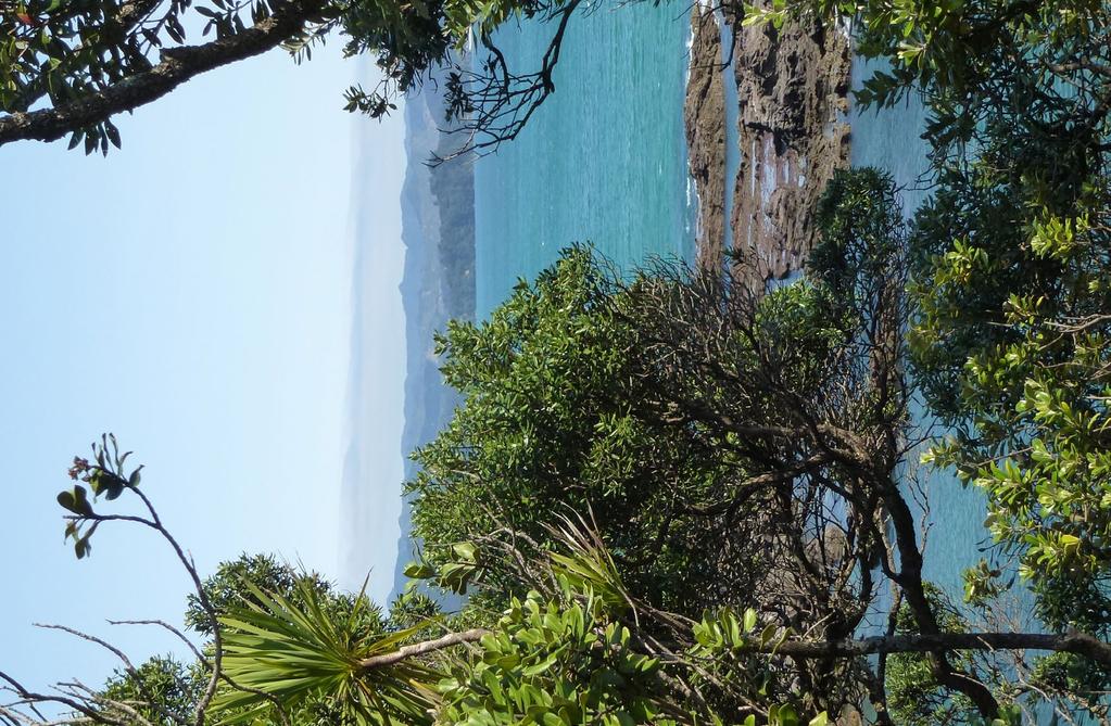
6 ABOUT THIS GUIDE NGĀ KŌRERO MŌ TE PUKA THE COROMANDEL PENINSULA IS A SPECIAL PLACE THAT DRAWS THOUSANDS OF SUMMER VISITORS TO ENJOY ITS SANDY BEACHES, DRAMATIC LANDSCAPE, EXTENSIVE FORESTS AND DIVERSITY OF WILDLIFE. THE COROMANDEL IS ONE OF THE MOST EXTENSIVELY VEGETATED PARTS OF THE WAIKATO REGION. ABOUT 60 PER CENT OF THE PENINSULA IS CLOTHED IN NATIVE VEGETATION, MUCH OF IT RECOVERING FROM MORE THAN A CENTURY OF LOGGING, MINING AND FARMING ACTIVITIES. WITH SO MUCH VEGETATION REMAINING ON THE PENINSULA, WHY THE NEED FOR A PLANTING GUIDE? Most of the remaining native forest is in large protected reserves in the higher altitude sub-montane and montane zones. The coastal and lowland zones, which support a different range of plants and animals, have experienced significant loss of vegetation and many of the remaining stands of bush are degraded by grazing, with little or no understorey. extinct wildlife and planting natives to recreate or enhance natural ecosystems. This guide will help you select and plant local native plants for your gardens and revegetation areas, or as specimen or shelter trees for your property. The focus of this planting guide is on forest species. For ideas on what to plant in wetlands, contact Waikato Regional Council for a copy of the wetland management series of factsheets or see waikatoregion.govt.nz (type freshwater wetlands in the search box). The peninsula is plagued by a wide range of weeds that take advantage of the warm, wet climate and are a threat to both agriculture and native biodiversity. Frequent rainstorms cause severe stream bank erosion, land slides and flooding which pollute waterways and threaten lives and property. Frequent rainstorms cause stream bank erosion Planting natives on the peninsula can help overcome these problems. Native plants can be used to: return native vegetation to the coastal and lowland zones, enhance waterways and provide seasonal food for native birds restore degraded stands of remnant trees, such as the isolated stands of pūriri and pukatea with no undergrowth replace exotic weeds and prevent other weeds establishing in cleared areas stabilise river banks and reduce erosion on bare land and newly created slips. Many agencies, community groups, and individuals are working hard to protect the natural values of the Coromandel Peninsula. They are removing weeds, controlling pests, reintroducing locally This guide is for the Coromandel Peninsula, including the northern side of Waihi Beach, crossing west including the Karangahake Gorge almost to Paeroa, and following the eastern bank of the Waihou River north to Thames. It includes coastal, lowland and hill country environments. The Kauaeranga River estuary and wetland are outside these ecological districts. 3
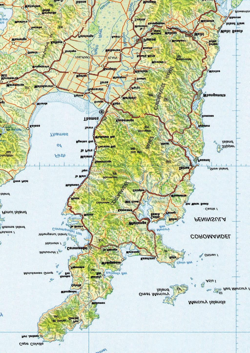


7 COLVILLE ECOLOGICAL DISTRICT TAIRUA ECOLOGICAL DISTRICT THAMES ECOLOGICAL DISTRICT WAIHI ECOLOGICAL DISTRICT 0 10km Coromandel ecological region and districts 4
8 COROMANDEL ECOLOGICAL REGION AND DISTRICTS ROHE ME NGĀ TAKIWĀ HAUROPI O KARAMAINA WHAT IS AN ECOLOGICAL DISTRICT? New Zealand has been divided into 268 different ecological districts based on geological, topographical, climatic and biological features that together define a characteristic landscape. Similar districts combine to form an ecological region. DESCRIPTION OF COROMANDEL ECOLOGICAL REGION AND DISTRICTS The Coromandel ecological region is a peninsula, bounded by sea to the north, west and the east. It also includes a number of offshore islands. The Coromandel Range was formed by prehistoric tectonic uplifting and volcanic activity. The geology is predominantly andesite to rhyolite, forming the characteristic peaks of the Pinnacles and Castle Rock, overlying basement sedimentary rocks (greywacke and argillites). Intense rainfall and stream development eroded the surface, creating the dissected steeplands. The eroded sediments were carried downstream and deposited to form river flats. The topography of the ecological region is varied, it includes: the northern end (Moehau Range) long ridges and steep streams radiating out to the coast, steep and broken hillslopes, floodplains, harbours and estuaries the western side (Colville to Thames) abrupt, steep drop to the coastline with well defined, deep valleys draining toward the west coast, broad ridges and a high plateau-like main range the eastern side (Waikawau Bay to Waihi) rolling hill country with broad river valleys draining to the sea via estuaries and harbours The climate, influenced by close proximity to the sea, is largely a moist oceanic climate, with mild winters and warm humid summers. Rainfall is spread fairly evenly throughout the year, though summer droughts and periods of localised torrential rain with associated flooding can occur. A high degree of variation in mean annual rainfall figures and temperature occurs between lowland and montane areas. The west coast is exposed to moist westerly winds, with a greater frequency of cloud, fog and mist cover. The Coromandel ecological region is divided into eight ecological districts, four of which are the focus of this planting guide: 1. COLVILLE ECOLOGICAL DISTRICT Covers the northernmost portion of the Coromandel Peninsula.The Moehau Range runs in a northwest to southeast direction along the length of the peninsula, reaching a height of 892m (Mt Moehau). 2. TAIRUA ECOLOGICAL DISTRICT Extends down the lower eastern coastline of the peninsula, from Whitianga to Whangamatā and across the main range to Thames. The central Coromandel Range dissects the district from north to south with high peaks of the Pinnacles (759m) and Table Mountain (832m). 3. THAMES ECOLOGICAL DISTRICT Extends down the lower western coastline of the peninsula and across towards Whitianga Harbour. This district includes a large amount of steep hill country and areas within the montane zone. 4. WAIHI ECOLOGICAL DISTRICT Extends down the east coast south of Whangamatā to the north side of Waihi Beach and crosss west almost to Paeroa, including the Karangahake Gorge. The terrain in this district is gentler than the previous three districts, with only small areas of the main divide higher than 500m above sea level. Each of these districts has a particular combination of landform, soil, vegetation and climate which brands them differently from each other and the rest of the country. the southern end (Ohinemuri Plain to east of Karangahake Gorge) large vegetated river catchments, small sandy beaches and coastal hills dropping steeply to sea cliffs. Soils vary with the topography. Thin soils over weathered rock are common on steep land areas. Deeper soils, sometimes formed from remnant volcanic ashes, dominate the more gentle rolling hills, and a mix of well-drained, imperfect and poorly drained fertile alluvial soils are found in the valleys. 5
9 VEGETATION IN THE COLVILLE, TAIRUA, THAMES AND WAIHI ECOLOGICAL DISTRICTS Originally these districts were covered in native vegetation, mainly forest of four types: coastal (pōhutukawa, kohekohe and pūriri) forest on the narrow coastal perimeter dense conifer (kahikatea, mataī and tōtara) forest on the flat, poorly drained river terraces mixed kauri-conifer-broadleaf forest and rimu-tawa forest throughout the hill country, with scattered pockets of taraire north of Tapu and Tairua montane conifer forest with patches of tōwai-tāwaritāwheowheo scrub at the high altitudes. These forests assisted in protecting and building the soil resource, playing a vital role in reducing erosion and the resultant effects of sedimentation and flooding. They helped to maintain a clean, healthy water resource and provide habitat for native animals including Archey s and Hochstetter s frogs, kiwi, Moehau stag beetle and tuatara. The vegetation has significantly changed since European settlement, with little primary forest remaining. Much of the remaining vegetation has either been cut over or has reestablished following fire or clearance for agriculture. Coromandel Peninsula is the transition zone between many northern and southern indigenous plant species. As a result, a relatively high number of species (>700) are found here, with a number of communities unique to the area. The summit of Mt Moehau (892m), for example, stands as the northern limit for many southern montane species such as mountain toatoa and pāhautea (New Zealand mountain cedar), which grow alongside northern species such as tōwai and tāwari. Coromandel Peninsula also has a diverse range of fauna present with many species distinctive to the Waikato region or no longer common elsewhere in New Zealand. ECOLOGICAL DISTRICT TOTAL AREA (HA) REMAINING INDIGENOUS VEGETATION (%)F REMAINING PRIMARY FOREST (%) Colville 77, Tairua 90, Thames 40, Waihi 47, For more detail on the natural history of the Coromandel ecological region, see E. A. Humphrys and A.M. Tyler s Coromandel Ecological Region: Survey Report for the Protected Natural Areas Programme. Waikato Regional Council s library has a copy available for you to view, by appointment. 6


10 COROMANDEL VEGETATION COVER IN 1840 COROMANDEL VEGETATION COVER TODAY Dense conifer forest Coastal broadleaf forest Kauri forest Dense conifer forest Regenerating scrubland Kauri forest Rimu - Tawa forest Regenerating forest Montane forest Regenerating scrubland Wetland Rimu - Tawa forest Taraire - Tawa forest Tawa forest Montane forest Wetland 7

11 WHAT IS SPECIAL ABOUT THESE ECOLOGICAL DISTRICTS? HE AHA I MOTUHAKE AI ĒNEI TAKIWĀ HAUROPI SPECIAL COMMUNITY PROJECTS The Coromandel Peninsula is a beautiful place. It has white sands, rugged coastal cliffs hung with pōhutukawa, historical relics from the mining and logging days, remnant kauri forests, populations of kiwi and native frog species, and extensive walking tracks over bush-clad ranges. These treasures are at risk. The Coromandel Peninsula is in close proximity to the main centres of Auckland and Hamilton, where one-third of New Zealand s population lives. It is the leisure and recreation destination of choice for many New Zealanders. There is very little original coastal forest remaining on the peninsula due to intensive development and pressure for access. Roading, drainage, rubbish dumps, marine farms, jetties, marinas, forestry, and farming are all placing greater pressure on the peninsula s natural resources These threats have spurred the community to action. There are now more than 76 environmental community groups active on the peninsula involved in voluntary activities such as animal and plant pest control, fencing and planting, development of accessways and recovery of threatened species. Local beach, harbour, catchment and kiwi restoration groups all operate with a common theme of people working together to protect our environment. Some community projects include: KIWIS FOR KIWI There are a number of kiwi volunteer groups active on the peninsula, involving partnerships between landowners, residents, Department of Conservation and Waikato Regional Council. The focus is on promoting the welfare of kiwi and their habitat, to ensure the long-term survival of wild kiwi populations. Kiwi also act as an indicator species, providing an indication of the health of the entire ecosystem. Actions that benefit kiwi also help other species, both flora and fauna, within the ecosystem. MOEHAU ENVIRONMENT GROUP (MEG) The Moehau Environment Group is focused on protecting and enhancing the natural environment of the northern Coromandel Peninsula. The group's objective is to achieve reintroduction and recovery of endangered species. Key activities are: possum and rat control programmes installing and maintaining stoat traps protecting kiwi habitat in conjunction with Department of Conservation assisting with the protection of päteke (brown teal) and nesting dotterel weeding and planting coastal environments running community education programmes. KAURI Kauri 2000 is a long term project to recreate significant stands of kauri on public conservation land on the Coromandel Peninsula. Less than 1per cent of New Zealand's kauri forest now exists as extensive logging, land use change and recently kauri dieback have impacted on the populations of this forest giant. The community group aims to plant up to 2,500 kauri seedlings per year to help increase the kauri population on the peninsula If you want to get involved with a community group, contact the Waikato Biodiversity Forum on 0800 BIODIV ( ) or visit for a list of groups in your area or of interest. Kiwi groups are involved in: predator and pest control covering thousands of hectares of kiwi habitat, much of the land in private ownership kiwi call monitoring advocacy to raise people s awareness about kiwi and promote kiwi-safe behaviours. More than 76 environmental community groups are active on the peninsula. 8
12 SPECIAL NATIVE WILDLIFE The Coromandel is one of the Waikato s biological treasures, especially the Moehau Range which is one of New Zealand s six biodiversity hot spots. All the Coromandel offshore islands managed by the Department of Conservation are free of introduced mammals. This allows species now absent from the mainland to survive and thrive, including tuatara, tīeke (North Island saddleback), hihi (stitchbird), Middle Island tusked wētā and many species of lizards and seabirds. On the mainland, the heavily forested ranges provide extensive habitat for many other threatened species, including bats, lizards, kākāriki, kākā and Coromandel brown kiwi. It is the only place in New Zealand where both Archey s and Hochstetter s frogs are found. Clear, cool streams that flow from the forested ranges harbour a healthy range of invertebrates and fish, including long and shortfinned eels, giant, banded and short-jawed kōkopu and kōaro. The Coromandel s freshwater fishery is dominated by banded kōkopu, probably because the large proportion of the Coromandel s rivers flow unimpeded into harbours. Dunes and beaches are home to New Zealand dotterel, wrybills, skinks and Caspian terns. Some special features of the Coromandel include: the world s only populations of the Moehau stag beetle, the Moehau wētā, and Middle Island tusked wētā a stronghold for Archey s and Hochstetter s frogs an estimated 500 kiwi living in the Moehau Range, managed in three large areas at Moehau, Kuaotunu, and Whenuakite a thriving population of pāteke (brown teal), introduced in the early 2000s at Port Charles, now spread through the north thriving island populations of lizards no longer found on the mainland, including Suter s and Whitaker s skinks the extremely rare Coromandel striped gecko. The intensive pest control work and planting being undertaken by agencies and community groups will help restore native wildlife populations on the peninsula. Coastal wetlands shelter matuku hūrepo (Australasian bittern), mohoperehū (banded rail) and mātātā (North Island fernbird), and the Firth of Thames is an internationally important area for migratory wading birds, with many coming from as far afield as Alaska and Siberia for the southern hemisphere summer. 9
Region 1 Piney Woods
 Region 1 Piney Woods Piney Woods 1. This ecoregion is found in East Texas. 2. Climate: average annual rainfall of 36 to 50 inches is fairly uniformly distributed throughout the year, and humidity and temperatures
CAPE COLVILLE PORT JACKSON. Fantail Bay. Shelly Beach Long Bay COROMANDEL TOWN PASSENGER FERRY. Waikawau. Orere Point.
 CAPE COLVILLE PORT JACKSON Fantail Bay Fletcher Bay COASTAL WALKWAY Stony Bay Sandy Bay MOEHAU RANGE PORT CHARLES Marine Reserve Heritage & Mining Surfing Kauri Heritage TAS M A N S E A WHANGEREI AUCKLAND
Conservation Volunteer Projects. Hauraki Area, Coromandel Peninsula
 Conservation Volunteer Projects Hauraki Area, Coromandel Peninsula Conservation Volunteer Programme Welcome to the Conservation Volunteer Programme. In this booklet are opportunities to participate in
Te Arai dune lands. Christine Wild for the Te Arai Beach Preservation Society
 Te Arai dune lands 1 Community concerns about the environmental impacts of increased subdivision provision on the Te Arai dune lands of the Landscape Protection Zone Rural; Mangawhai/Pakiri Christine Wild
Significant Natural Area Assessment. Property Name: Hillend Station
 Private Bag 50072, Queenstown 9348, New Zealand QUEENSTOWN, 10 Gorge Road, Phone +64 3 441 0499, Fax +64 3 450 2223 WANAKA, 47 Ardmore Street, Phone +64 3 443 0024, Fax +64 3 450 2223 Significant Natural
Hawke s Bay Regional Parks Network. Pekapeka Regional Park Individual Park Plan
 Hawke s Bay Regional Parks Network Pekapeka Regional Park Individual Park Plan 2015-2024 Hawke s Bay Regional Council 159 Dalton Street Private Bag 6006 Napier 4110 Hawke s Bay New Zealand Telephone: 0800
Case Study: 1. The Clarence River Catchment
 Case Study: 1. The Clarence River Catchment The NSW coastline is a great natural asset, making an enormous contribution to the economy. The resources of coastal catchments such as the Clarence River Catchment,
The Geological Pacific Northwest. Wednesday February 6, 2012 Pacific Northwest History Mr. Rice
 The Geological Pacific Northwest Wednesday February 6, 2012 Pacific Northwest History Mr. Rice 1 Free Response #2 Please do not simply list the items for this response. Full sentences!!! Minimum of 3-5
Ecology and Landscapes Briefing 26 July 2018
 Ecology and Landscapes Briefing 26 July 2018 Part 1 1. Introductions Part 2 Part 3 Part 4 2. Council Obligations 3. History of Hutt development and native vegetation clearance 4. Significant vegetation
IMPACTS OF THE RECENT TSUNAMI ON THE BUNDALA NATIONAL PARK THE FIRST RAMSAR WETLAND IN SRI LANKA
 IMPACTS OF THE RECENT TSUNAMI ON THE BUNDALA NATIONAL PARK THE FIRST RAMSAR WETLAND IN SRI LANKA by C.N.B. Bambaradeniya, IUCN The World Conservation Union, Sri Lanka Country Office (Email: cnb@iucnsl.org)
Biodiversity Planning with 50/50 vision
 1 Biodiversity Planning with 50/50 vision Mairi Jay Senior Lecturer, Department of Geography University of Waikato New Zealand is of world importance for its native biological diversity. Because of the
Northland Regional Landscape Assessment Worksheet
 Northland Regional Landscape Assessment Worksheet DESCRIPTION AND CHARACTERISATION Component Land Types Northern and eastern dissected ranges; high relief land type Unit name MT TIGER BUSH AND REMNANTS
Summer Holiday Programme
 Summer oliday Programme Jan u a ry 2 0 1 9 Explore Nature Fun A c ti v it i es FOR TE WOLE FAMILY All Profit Goes to KIWI PROTECTION ON TE COROMANDEL www.meg.org.nz For Bookings call 07 866 6903 or 021
NARRABEEN LAGOON SUMMIT am Wednesday, 13 April 2005 Warringah Council Chambers, 725 Pittwater Road, Dee Why.
 NARRABEEN LAGOON SUMMIT 9.15 9.30am Wednesday, 13 April 2005 Warringah Council Chambers, 725 Pittwater Road, Dee Why. NSW Minister for the Environment, the Hon. Bob Debus I am very pleased to be here to
What Is An Ecoregion?
 Ecoregions of Texas What Is An Ecoregion? Ecoregion a major ecosystem with distinctive geography, characteristic plants and animals, and ecosystems that receives uniform solar radiation and moisture Sometimes
Park-specific management and policies Belmont Regional Park
 Park-specific management and policies Belmont Regional Park 6.3 Belmont Regional Park 6.3. Legal status Territorial Authority: Hutt City Council, Porirua City Council, Wellington City Council Title Held
A summary of Draft Makara Peak Mountain Bike Park Master Plan
 A summary of Draft Makara Peak Mountain Bike Park Master Plan OVEMBER 216 Image: Peter Marshall 2 3 Introduction Since it was established in 1998, the Makara Peak Mountain Bike Park (Makara Peak) has grown
Map 7 SECTION C: WAIKATO S EAST COAST MARINE AND TERRESTRIAL AREAS. Miranda. Miranda. Legend. Hauraki Coastal Natural Character Ratings: Level 4
 95 Miranda SECTION C: WAIKATO S EAST COAST MARINE AND TERRESTRIAL AREAS Miranda Map 7 Legend Extent of Coastal Environment Coastal Terrestrial Area 2: Hauraki Hauraki Coastal Natural Character Ratings:
Priority Species, Communities, Ecosystems, and Threats
 Priority Species, Communities, Ecosystems, and Threats East Gippsland Regional Catchment Strategy 2015/2016 1.0 Objective This document aims to assist in the preparation of project applications for 2015-2016
BEFORE THE AUCKLAND UNITARY PLAN INDEPENDENT HEARINGS PANEL
 BEFORE THE AUCKLAND UNITARY PLAN INDEPENDENT HEARINGS PANEL IN THE MATTER of the Resource Management Act 1991 and the Local Government (Auckland Transitional Provisions) Act 2010 AND IN THE MATTER of Topic
SES Refer to the disclaimer at the beginning of this appendix.
 Appendix 1d Schedule of sites of ecological significance - inner islands AP IU ROA D O RA PIU R OAD OR 30 30 ORAPIU R AD O 30 30 OR AP IU RO AD Omaru Bay Forest : 25-12 SES 30 1:4,000 0 25 50 100 This
2.0 Physical Characteristics
 _ 2.0 Physical Characteristics 2.1 Existing Land Use for the Project The site is comprised of approximately 114 acres bounded by Highway 101 to the north, the existing town of Los Alamos to the east, State
Andy Sharp Natural Resources Northern & Yorke. Brooke Liebelt Yorke Peninsula Tourism
 Andy Sharp Natural Resources Northern & Yorke Brooke Liebelt Yorke Peninsula Tourism Rewilding is about restoring natural processes, to: improve conservation outcomes improve the ecosystem services provided
Conservation Partners for the National Reserve System Program: a Western NSW focus
 Conservation Partners for the National Reserve System Program: a Western NSW focus Cooper, N. 1, Webber, L. 2, Nicolson, K. 3 1 Department of Environment, Climate Change and Water NSW, PO Box 788 Broken
The Aotea Track offers a range of spectacular landscapes, superb views and rich history.
 Aotea Track Located in Great Barrier Island/Aotea in the Auckland region The Aotea Track offers a range of spectacular landscapes, superb views and rich history. Travel over streams that show off a constant
Wetlands you can visit in the Wellington Region
 Wetlands you can visit in the Wellington Region The Wellington Region at the base of the North Island lies on an active fault-zone, comprising an extensive valley nestled between two coastal ranges. Its
World Heritage Site 1. World Heritage Site 2 OCEANIA
 World Heritage Site 1 This site is managed by both the national government of this country in the southern hemisphere and the native people who have lived here for thousands of years. Tidal plains, lowlands,
1 INFORMATION REQUIREMENTS
 1 INFORMATION REQUIREMENTS 1.1 BACKGROUND 2 1.2 WHAT IS THE DISTRICT PLAN 3 1.3 DISTRICT PLAN STRUCTURE 4 1.4 HOW TO USE THE DISTRICT PLAN 5 1.5 STRATEGIC FRAMEWORK 6 Whanganui District Plan (15 January
UNIT 5 AFRICA PHYSICAL GEOGRAPHY SG 1 - PART II
 UNIT 5 AFRICA PHYSICAL GEOGRAPHY SG 1 - PART II III. CLIMATE & VEGETATION A. The four main climate zones are tropical wet, tropical wet/dry (split into monsoon & savanna), semiarid, and arid. Other climate
STORNETTA BROTHERS COASTAL RANCH
 STORNETTA BROTHERS COASTAL RANCH Location: Surrounding Point Arena Lighthouse and immediately south of Manchester State Park Mendocino Co., CA Acres: 1,860 Resources: Over two miles of Pacific Ocean coastline
The Mackenzie Basin ecology and protection
 The Mackenzie Basin ecology and protection Photo Chris Woolmore Nicholas Head Plant Ecologist Acknowledgements Warren Chinn, Joy Comrie, Iain Gover, Di Lucas, Brian Patrick, Geoff Rogers, Susan Walker,
17.24 Te Muri Regional Park
 17.24 Te Muri Regional Park 17.24.1 Park values 1.1 Land Form Located 46 kilometres from central Auckland on the region s north eastern coast, the 407 hectare park extends three kilometres inland from
Park-specific management and policies Wainuiomata Recreation Area
 Park-specific management and policies Wainuiomata Recreation Area 6.8 Wainuiomata Recreation Area 6.8.1 Legal status Title held: Legislative status: Wellington Regional Council Administered under Local
The South Gippsland Koala. For over 60 years, the plantation industry has shared a unique relationship with the Strzelecki Koala. protection.
 The South Gippsland Koala For over 60 years, the plantation industry has shared a unique relationship with the Strzelecki Koala. protection harmony THE CO-EXISTENCE OF THE KOALA WITH THE PLANTATIONS co-existence
PART 3 Natural Heritage Features and Landscape
 PART 3 Natural Heritage Features and Landscape PAGE 63 PAGE 64 3 NATURAL HERITAGE FEATURES AND LANDSCAPE 3.1 LAND, LANDFORMS AND LANDSCAPE The WRHA Act identifies a number of features in Section 7 National
Potomac Gorge. Resource Booklet. A Natural Monument in the Shadow of National Monuments. Bridging the Watershed. Potomac Gorge 75
 Potomac Gorge Potomac Gorge A Natural Monument in the Shadow of National Monuments Resource Booklet Bridging the Watershed An outreach program of the Alice Ferguson Foundation in partnership with the National
Lord Howe Island Group native species and ecological communities
 CASE STUDY EXAMPLE OF TRENDS IN SPECIES AND COMMUNITIES NEW SOUTH WALES Lord Howe Island Group native species and ecological communities Description The Lord Howe Island Group is located 760 kilometres
Title/Name of the area: Chwaka Bay, Zanzibar
 Title/Name of the area: Chwaka Bay, Zanzibar Presented by: Dr. Charles Lugomela, Ag. Head, Department of Aquatic Sciences and Fisheries, University of Dar es Salaam, P.O. Box 35064 Dar es Salaam, Tanzania
Biosphere Reserve of IRAN. Mehrasa Mehrdadi Department of Environment of IRAN
 Biosphere Reserve of IRAN Mehrasa Mehrdadi Department of Environment of IRAN Biodiversity in Iran Comprises a land area of 1.64 million km² The average altitude is over 1200 m, Is bordered by Turkmenistan,
Whatungarongaro he tangata, toitu te whenua. People come and go but the land endures. leave no trace new zealand
 Pocket Guide Leave No Trace Leave No Trace New Zealand promotes and inspires responsible outdoor recreation through education, research and partnerships. This pocket guide is a part of an education programme
3.0 EXISTING PARK & RECREATION SPACE
 3.0 EXISTING PARK & RECREATION SPACE TOWN PARK & RECREATION SPACE An inventory of current parks and recreation area in the Town of Cedarburg is shown in Table 3. These areas total roughly 381.89 acres.
Friday, November 10, 2017
 Friday, November 10, 2017 Andes and Midlatitude Countries Objective: Summarize the main physical features and regions of the Southern Cone. Identify and locate the urban centers and understand the pattern
MANAGEMENT DIRECTION STATEMENT
 Lower Mainland District MAAGEMET DIRECTIO STATEMET January 2001 for Liumchen Ecological Reserve Ministry of Environment Lands and Parks BC Parks Division Table of Contents Page Introduction... 1 Purpose
Coromandel Recreation
 Visitor information COROMANDEL Introduction We hope you enjoy your visit to the Coromandel. For more information go to the DOC website at www.doc.govt.nz or contact: Department of Conservation Kauaeranga
Western Australia The State of Islands
 Western Australia The State of Islands How many islands? There are c. 3700 islands off the coast of WA 2 estimates: 3424 (State), 3747 (Commonwealth) mainly continental islands in State waters, most managed
Chapter Objectives. Describe the dominant landforms and natural resources of Southeast Asia. Discuss Southeast Asia s climate and vegetation.
 Chapter Objectives Describe the dominant landforms and natural resources of Southeast Asia. Discuss Southeast Asia s climate and vegetation. The Land Section 1 Objectives Describe how tectonic plates and
Trelissick Park is zoned Conservation Site under the District Plan and is classified as Scenic Reserve under the Reserves Act 1977.
 SUBURBAN RESERVES MANAGEMENT PLAN 2015 I 49 3.2 SECTOR 2 Trelissick Park Trelissick Park is located between the Johnsonville railway line and Ngaio Gorge Road. Most of the park lies on the northern side
Terrestrial Protected Area Nomination: Central Mangrove Wetland South-West, Grand Cayman
 Terrestrial Protected Area Nomination: Central Mangrove Wetland South-West, Grand Cayman The attached nomination, proposing that a parcel of land in the Central Mangrove Wetland be made a Protected Area
Queensland s Commitment to the World Heritage Convention
 WORLD HERITAGE LEADERSHIP Queensland s Commitment to the World Heritage Convention The Hon Andrew Powell MP Minister for Environment and Heritage Protection The theme for this symposium Australia s World
Hudson Bay Lowlands Proposed Protected Areas
 Hudson Bay Lowlands Proposed Protected Areas Hudson Bay Lowlands Proposed Protected Areas The Protected Areas Initiative has identified portions of the Hudson Bay Lowlands region that have significant
Coromandel Recreation
 Offshore islands There are many islands off the Coromandel Peninsula ranging in size from rock stacks of less than one hectare to islands as large as 1,900 ha. Some are privately owned, some Māori-owned
Ngaio Walking Tracks map 1
 Skyline Walkway Part of this walkway runs north-south along the ridge between Mt Kaukau and Crofton Downs. It is 4 km long and takes two hours at an easy pace. On a clear day there are spectacular views
PAKARU ROAD FOREST. Ecological unit. Landform/geology. Taraire forest on hillslope (20%) (b) Kanuka/manuka tanekaha forest on hillslope (80%)
 (b) Kanuka/manuka tanekaha forest on hillslope (80%)") PAKARU ROAD FOREST Survey no. Q05/005 Survey date 19 December 1994 Grid reference Q05 147 440 95 ha Altitude 20 140 m asl Ecological unit Taraire forest on hillslope (20%) (b) Kanuka/manuka tanekaha forest
PAKARU ROAD FOREST Survey no. Q05/005 Survey date 19 December 1994 Grid reference Q05 147 440 95 ha Altitude 20 140 m asl Ecological unit Taraire forest on hillslope (20%) (b) Kanuka/manuka tanekaha forest
Engaging the community as volunteers the case of Lord Howe Island World Heritage Area
 WORLD HERITAGE AND THE COMMUNITY Engaging the community as volunteers the case of Lord Howe Island World Heritage Area Stephen Wills The Lord Howe Island Group (LHIG) is an area of spectacularly beautiful
Marchand Provincial Park. Management Plan
 Marchand Provincial Park Management Plan 2 Marchand Provincial Park Table of Contents 1. Introduction... 3 2. Park History... 3 3. Park Attributes... 4 3.1 Natural... 4 3.2 Recreational... 4 3.3 Additional
Summary of prescribed fires in Prince Albert National Park 2015
 Summary of prescribed fires in Prince Albert National Park 2015 Prince Albert National Park conducted four controlled fires in spring 2015, plus an additional fire in October. Fuel Management for Hazard
Map 13 SECTION C: WAIKATO S EAST COAST MARINE AND TERRESTRIAL AREAS. Wainuiototo Bay. Whangapoua Harbour Islands. Te Rehutae Point
 139 Wainuiototo Bay Te Rehutae Point Whangapoua Harbour Islands Whangapoua Harbour Islands 0 1 km SECTION C: WAIKATO S EAST COAST MARINE AND TERRESTRIAL AREAS Map 13 Legend Extent of Coastal Environment
There are actually six geographic sub-regions, three in both the uplands and the lowlands.
 6 Regions of AR Although Arkansas is most easily divided into two distinct geographical regions, the northwestern uplands and the southeastern lowlands, this description does not accurately portray the
VARGAS ISLAND PROVINCIAL PARK
 VARGAS ISLAND PROVINCIAL PARK PURPOSE STATEMENT AND ZONING PLAN February 2003 VARGAS ISLAND PROVINCIAL PARK Purpose Statement and Zoning Plan Primary Role The primary role of Vargas Island Park is to protect
2.0 PARK VISION AND ROLES
 2.0 PARK VISION AND ROLES 2.1 Significance in the Protected Area System Marble Range and Edge Hills provincial parks protect 6.8% of the Pavillion Ranges Ecosection, which is located in the Southern Interior
South Texas Plains. Texas, Our Texas
 South Texas Plains This is a region characterized by considerable variety. Climatically, the South Texas Plains region is sub-humid to dry. The in the north part of the South Texas, erosion of the Edwards
SUBMISSION FROM BIG SCRUB LANDCARE ON THE DRAFT NSW BIODIVERSITY CONSERVATION BILL AND ACCOMPANYING LEGISLATION AND CODES
 TP Draft 23 June 2016 SUBMISSION FROM BIG SCRUB LANDCARE ON THE DRAFT NSW BIODIVERSITY CONSERVATION BILL AND ACCOMPANYING LEGISLATION AND CODES ABOUT THIS SUBMISSION 1. This submission by Big Scrub Landcare
Spatial Distribution and Characteristics of At-Risk Species in the Southeast U.S.
 Nicholas Institute for Environmental Policy Solutions Scoping Document Part 2 Exploratory Analysis of Characteristics and Trends of At-Risk Species in the Southeast U.S. Spatial Distribution and Characteristics
Biodiversity Funds Funding Round 16 - Project Briefs
 Biodiversity Funds Funding Round 16 - Project Briefs Project No Project Name Organisation Fund Amount Region ADV-437 Freshwater Biodiversity Advice Service Nelson Marlborough Fish & Game Advice $100,000
The Values of the Tasmanian Wilderness World Heritage
 The Values of the Tasmanian Wilderness World Heritage Area The natural and cultural values that have resulted in the TWWHA being reserved as conservation land and inscribed on the World Heritage List are:
CITIES AND REGIONS FOR TOURISM: THE CAPE TOWN EXPERIENCE CITIES SUMMIT COP13 I 10 DECEMBER 2016
 CITIES AND REGIONS FOR TOURISM: THE CAPE TOWN EXPERIENCE CITIES SUMMIT COP13 I 10 DECEMBER 2016 INTRODUCTION The Opportunity City Cape Town (2,461 km s in extent) contains:- Globally important Cape Floral
EUROPEAN COMMISSION DG XI.D.2. COUNCIL DIRECTIVE 79/409/EEC on the conservation of wild birds. and
 EUROPEAN COMMISSION DG XI.D.2 COUNCIL DIRECTIVE 79/409/EEC on the conservation of wild birds and COUNCIL DIRECTIVE 92/43/EEC on the conservation of natural habitats and of wild fauna and flora STANDARD
Cat Island Chain Background & Access Guide
 Cat Chain Background & Access Guide Brown County Port & Resource Recovery Department 2561 S. Broadway, Green Bay, WI 54304 (920) 492-4950 www.portofgreenbay.com January 2018 1 Restoration of the Cat Chain
2.1 What is the climate like?
 José Medeiros This fact sheet allows you to see how varied the countryside is across Brazil. 2.1 What is the climate like? Most of Brazil is in the Southern Hemisphere, where the seasons are the opposite
Significant Natural Area Assessment. Property Name: Cochrane & Ashkel Ltd. Area Size (ha): 5.33
: 5.33") Private Bag 50072, Queenstown 9348, New Zealand QUEENSTOWN, 10 Gorge Road, Phone +64 3 441 0499, Fax +64 3 450 2223 WANAKA, 47 Ardmore Street, Phone +64 3 443 0024, Fax +64 3 450 2223 Significant Natural
Private Bag 50072, Queenstown 9348, New Zealand QUEENSTOWN, 10 Gorge Road, Phone +64 3 441 0499, Fax +64 3 450 2223 WANAKA, 47 Ardmore Street, Phone +64 3 443 0024, Fax +64 3 450 2223 Significant Natural
Post-fire Recovery: Assessment of the Warrumbungles Fire by the Burned Area Assessment Team
 Post-fire Recovery: Assessment of the Warrumbungles Fire by the Burned Area Assessment Team SALLY MCINNES-CLARKE 1, MARGARET KITCHIN 2, SIMON HEMER 3, RICHARD YEOMANS 3 & BELINDA KENNY 3 1 Office of Environment
TE IKA-A-MĀUI NORTH ISLAND 2017/2018
 TE IKA-A-MĀUI NORTH ISLAND 207/208 Responsible camping You could get a $200 instant fine by: Freedom camping overnight where there is a no camping sign. Freedom camping overnight where there is a self-contained
Creation of a Community-managed Biodiversity Park in the Saloum Delta of Senegal. Voré Gana Seck Director GREEN Senegal for People, Land, Ocean
 Creation of a Community-managed Biodiversity Park in the Saloum Delta of Senegal Voré Gana Seck Director GREEN Senegal for People, Land, Ocean Rationale for the Creation of the Biodiversity Park F In line
Wetlands Reservoirs of Biodiversity. Billy McCord, SCDNR
 Wetlands Reservoirs of Biodiversity Billy McCord, SCDNR Estuaries Tidal Deepwater Intertidal Salt Marsh Tidal Riverine Fresh & Brackish Deepwater Tidal Emergent Marsh Freshwater Riverine Seasonally Flooded
Settlement Patterns West of Ma ax Na, Belize
 SETTLEMENT PATTERNS WEST OF MA AX NA, BELIZE 1 Settlement Patterns West of Ma ax Na, Belize Minda J. Hernke Faculty Sponsor: Kathryn Reese-Taylor, Department of Sociology/Archaeology ABSTRACT The focus
Michipicoten Island Regional Plan
 Michipicoten Island Regional Plan This is one of twenty Regional Plans that support implementation of the Lake Superior Biodiversity Conservation Strategy (Strategy). The Strategy, prepared and overseen
Mackinnon Esker Ecological Reserve Draft - Management Plan
 Mackinnon Esker Ecological Reserve Draft - Management Plan May 2011 Photo Credit: This document replaces the direction provided in the Carp Lake Provincial Park and Protected Area and Mackinnon Esker Ecological
The Conservation Contributions of Ecotourism Cassandra Wardle
 The Conservation Contributions of Ecotourism Cassandra Wardle PhD Candidate, Gold Coast, Australia Supervisors: Ralf Buckley, Aishath Shakeela and Guy Castley State of the Environment State of the Environment
Biodiversity is life Biodiversity is our life
 Biodiversity is life Biodiversity is our life Chapter 10 Section 2 Biodiversity at Risk Objectives Define and give examples of endangered and threatened species. Describe several ways that species are
Section 2a. District profile
 Section 2a District profile District Profile The Hauraki District contains a diversity of land, communities and economies. Our location puts us in the golden triangle between Auckland, Tauranga and Hamilton,
SUPPORT TO WATER RESOURCES MANAGEMENT IN THE DRINA RIVER BASIN DRAFT ROOF REPORT INTRODUCTION AND GENERAL APPROACH
 SUPPORT TO WATER RESOURCES MANAGEMENT IN THE DRINA RIVER BASIN DRAFT ROOF REPORT INTRODUCTION AND GENERAL APPROACH Nadja Zeleznik, REC Public Concultation Beograd, Serbia, 4 July 2017 1 1. Introduction
Colorado Life Zone Scavenger Hunt
 Colorado Life Zone Scavenger Hunt Below are worksheets created for all the habitats or life zones. They were designed with the intention of breaking the class up into small groups, and having students
Backgrounder Plains Bison Reintroduction to Banff National Park
 Backgrounder Plains Bison Reintroduction to Banff National Park Introduction The five-year reintroduction project is a small- scale initiative that would inform future decisions regarding the feasibility
1.15 TONGARIRO GEOTHERMAL FIELD. List of Geothermal Sites. Te Maari Craters. Emerald Lakes. Contract Report No. 2348
 1.15 TONGARIRO GEOTHERMAL FIELD List of Geothermal Sites TGV01 TGV02 TGV03 TGV04 Te Maari Craters Ketetahi Emerald Lakes Red Crater 2011 452 TGV01 Te Maari Craters 0508 WILDNZ www.wildlands.co.nz ± ± 0
Section 2 North Slope Ecoregions and Climate Scenarios
 Section 2 North Slope Ecoregions and Climate Scenarios North Slope Ecoregions The geographic/ecological scope of the workshop will be freshwater and terrestrial systems of the North Slope of Alaska, with
Chapter 7 Geography and the Early Settlement of Egypt, Kush, and Canaan
 Chapter 7 Geography and the Early Settlement of Egypt, Kush, and Canaan How did geography affect early settlement in Egypt, Kush, and Canaan? Section 7.1 - Introduction RF/NASA//Corbis This satellite photograph
IMPORTANCE OF MANGROVES
 IMPORTANCE OF MANGROVES WHAT ARE MANGROVE TREES? They are shrubs or small trees that grow in coastal saline or brackish water (salt water). A Mangrove is a tropical marine tree or a shrub. It has special
THE STATUS OF DORCAS GAZELLE IN ETHIOPIA
 THE STATUS OF DORCAS GAZELLE IN ETHIOPIA Paper presented in the second workshop on the conservation and restoration of Sahelo-Saharan Antelopes. 1-5 May 2003 by Mohammed Ali and Ababu Ange Zeleke May /
SELF-ASSESSMENT CHECKLIST
 Tourism and Mountains A Practical Guide to Managing the Environmental and Social Impacts of Mountain Tours Using this Self-Assessment Checklist This checklist has been developed to help mountain-based
GLENTHORNE NATIONAL PARK OUR NEW BACKYARD
 2036 WILL MARK OUR STATE S BICENTENARY By the time our State turns 200 years old, I want South Australia to be a place of prosperity. Planning and delivering on my vision for a better future starts now.
Alaskan/Fjordland Pacific (Ecoregion 22)
") Alaskan/Fjordland Pacific (Ecoregion 22) Background The Alaskan/Fjordland Pacific Ecoregion is an area of abundant marine resources. The ecoregion begins at Vancouver Island and moves up the Gulf of Alaska
Alaskan/Fjordland Pacific (Ecoregion 22) Background The Alaskan/Fjordland Pacific Ecoregion is an area of abundant marine resources. The ecoregion begins at Vancouver Island and moves up the Gulf of Alaska
MAIN LAKE PROVINCIAL PARK
 MAIN LAKE PROVINCIAL PARK PURPOSE STATEMENT AND ZONING PLAN March 2003 MAIN LAKE PROVINCIAL PARK Purpose Statement and Zoning Plan Primary Role The primary role of Main Lake Park is to protect a biologically
Chapter 20. The Physical Geography of Africa South of the Sahara
 Chapter 20 The Physical Geography of Africa South of the Sahara Chapter Objectives Identify the major landforms, water systems, and natural resources of Africa south of the Sahara. Describe the relationship
The Roots of Carrying Capacity
 1 Applying Carrying Capacity Concepts in Wilderness 1872 1964...shall be preserved for the use & enjoyment of the American people...in such manner as will leave them unimpaired for future generations...
Birch Point Provincial Park. Management Plan
 Birch Point Provincial Park Management Plan 2 Birch Point Provincial Park Table of Contents 1. Introduction... 3 2. Park History... 3 3. Park Attributes... 4 3.1 Natural... 4 3.2 Recreational... 4 4. Park
Objective. Students will familiarize themselves with the physical features and climates of Latin America.
 Journal Write KWL What do you KNOW about Latin America? What do you WANT TO KNOW about Latin America? What did you LEARN today that you didn t know before? Latin America Objective Students will familiarize
photos Department of Environment and Conservation Biodiversity Conservation
 photos Department of Environment and Conservation Biodiversity Conservation EcoEducation - making the connections to biodiversity conservation Do you consider experiential learning of biodiversity in the
Draft Marine and Harbour Facilities Strategy
 Draft Marine and Harbour Facilities Strategy Vision The Coromandel peninsula is a destination of choice for safe, sustainable and accessible marine and harbour facilities that are fit for purpose to meet
Applying Carrying Capacity Concepts in Wilderness
 Applying Carrying Capacity Concepts in Wilderness...shall be preserved for the use & enjoyment of the American people...in such manner as will leave them unimpaired for future generations... CSS 490 Professor
Criddle/Vane Homestead Provincial Park. Management Plan
 Criddle/Vane Homestead Provincial Park Management Plan 2 Criddle/Vane Homestead Provincial Park Table of Contents 1. Introduction... 3 2. Park History.... 3 3. Park Attributes.... 4 3.1 Natural.... 4 3.2