Ngaio Walking Tracks map 1
|
|
|
- Erik Garey Clarke
- 6 years ago
- Views:
Transcription


1 Skyline Walkway Part of this walkway runs north-south along the ridge between Mt Kaukau and Crofton Downs. It is 4 km long and takes two hours at an easy pace. On a clear day there are spectacular views of the Kaikoura ranges, the Marlborough Sounds, Wellington city and harbour and the Tararua and Orongorongo ranges. The walkway is open to walkers and mountain bikers. Local access points to the Skyline Walkway are: Through the car park at the end of Chartwell Drive Bell s Track, from the end of Awarua St. Khandallah Park. to Mt Kaukau join up with the Skyline Walkway. Bell s Track This re-established route starts at the top of Awarua Street and joins a farm track up to a saddle on the ridge. It originally provided access between farms in Ohariu Valley and railway station. From the top there are fantastic views over Wellington and the South Island. A dedicated care group is restoring the vegetation. Huntleigh Park Reserve This lesser known area is a WCC reserve. Adjoining bush is administered by the Girl Guides Association. Access is from behind the Playcentre in Silverstream Road, Crofton Downs and Huntleigh Park Way. are marked with small coloured posts. Some care is needed in several areas that are quite steep. Orleans Makererua Reserve (Pukatea Track) This small reserve has an interesting 10 min. track running from Makererua Street (off Heke Street) to Orleans Street (off Chelmsford Street). There is a gently sloped grassed area at the Orleans end. The reserve is notable for a number of fine specimens of native trees (pukatea, kahikatea and titoki) that are survivors from the original bush. A local care group looks after the area. Safety Northern Walkway The track in Trelissick Park from Hanover Street to Waikowhai Street is part of the Northern Walkway. From Waikowhai Street a short road walk leads to Cummings Park. From Awarua Street the walkway goes along Khandallah Road and Simla Crescent to Khandallah Park where it ascends to the top of Mt Kaukau. Cummings Park This grassed flat park is behind the shops. There is a stream, an old totara, a sculpture, seating, a children s playground and a designated off-the-lead dog exercise area. Heke Street Reserve A pleasant track through this reserve links Crofton Downs and. Access is from the end of Collingwood Street and between 45 and 47 Thatcher Crescent. A side track runs to Heke Street emerging next to 41 Heke Street. How to get there: map 1 PREPARED BY Crofton Downs Residents Association, 3rd edition. April 2013 Trains Local stations on the Johnsonville Line are Crofton Downs,, Awarua Street, Simla Crescent and Box Hill. Several bus routes connect from Wellington to. Metlink has train and bus timetables and journey planner. (ph ) Adventure Smart has outdoor safety information Stout shoes or boots should be worn and a waterproof jacket and warm clothing carried in case of a change in the weather. Tell someone your plans. These precautions are essential if you plan to walk on the exposed skyline ridges.
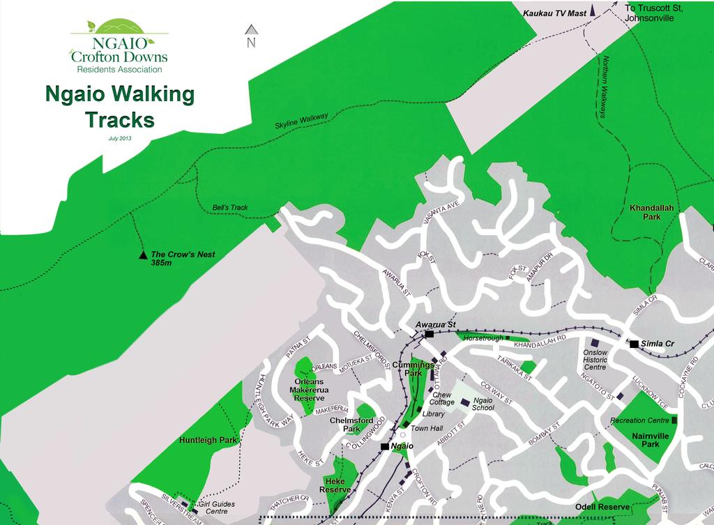
2 map 1
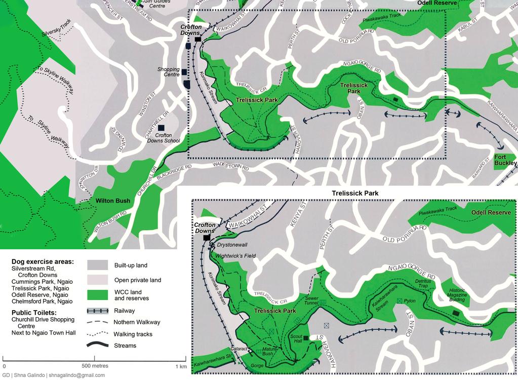
3 map 2
4 Trelissick Park The park covers a large area of rugged landscape extending from the lower Gorge to Waikowhai Street with an extensive network of walking tracks. Cared for by a dedicated group of volunteers in co-operation with the Wellington City Council for over 20 years, the park has regenerating bush and a number of heritage trees. There are five main entrances to Trelissick Park: Gorge / Kaiwharawhara Road Gorge Road Trelissick Crescent Waikowhai Street Hanover Street From the Waikowhai Street entrance (near the railway overbridge between and Crofton Downs) the track descends to Wightwick s Field, a flat grassed area with a picnic table and seats. Not far from the Waikowhai Street entrance the track is carved out of solid rock. This is believed to be the remains of a nineteenth century logging track. A few metres further on, the Silverstream from Crofton Downs emerges from a culvert. Adjacent to this are the remains of a rare old drystone wall constructed when the Wellington-Manawatu Railway Line was built in the 1880s. The track follows the Korimako Stream until it intersects with tracks from Trelissick Crescent and Hanover Street, Wadestown. Piwakawaka Track (Odell s Reserve) Access is from alongside 14 Punjab Street or from Old Porirua Road near the entrance to the Harbour Lights subdivision. This track passes through regenerating bush and provides a convenient segment of a circular walk in association with the Bridle Track. The highest point, at the water tanks, provides spectacular views of the city, harbour and itself. Great vantage point for Guy Fawkes night. Silversky Track The Silversky Track is a walking and biking track from Downing Street up towards the Crofton Downs transformers. From there you can follow a 4 wheel drive track to the Skyline Walkway. Otari Wilton s Bush This unique sanctuary in nearby Wilton is devoted to indigenous New Zealand plants. It has a range of tracks through forest, gardens, open spaces and picnic areas. This is one of the finest showcases of native flora in the country. It is a national treasure. Access is from Wilton Road, John Witton Drive or Churchill Drive. Otari is easy walking distance from. Go along Churchill Drive to Blackridge Road. The lower entrance is on the right. map 2 PREPARED BY Crofton Downs Residents Association, 3rd edition. April 2013 Just before the junction with the Wadestown-Trelissick section of the track, a zigzag track provides access to one of the area s finest scenic features. This is the emergence of the stream from a section known as The Gorge from its narrowness and steep sides. At the junction there are several notable trees nearby especially two mature specimens of miro and totara. From the junction another track runs around the steep hillside to Gorge Road. this track requires care due to the steep slope. Downhill from the intersection, the left hand track near the river (now called the Kaiwharawhara Stream) continues to the two lower Gorge Road exits. A major point of interest towards the end of the track is the remains of an historic powder magazine built in and used for storing explosives during the Russian invasion scare of the 1880s. In 2002 the site was damaged when a bank robbery getaway car was set alight. Suburban Walkways and Crofton Downs have a large number of zigzag walkways and steps between streets. These provide easier access for pedestrians to shops and transport. These are shown on the map as dotted lines linking streets. They complement the track system and provide interesting walks and shortcuts through the suburbs. Exercise Areas There are five off-the-leash dog exercise areas in and Crofton Downs: the whole of Trelissick Park, Chelmsford Park off Lower Chelmsford Street, Cummings Park, Silverstream Road Reserve and Odell s Reserve.
5 , one of Wellington s northern suburbs, has many accessible bush reserves and walking tracks running from the lower Gorge to the Skyline walkway. There are short tracks for family forays or longer extended walks for fitness. Early Maori Kaiwharawhara was a Te Atiawa Pa at the mouth of the Kaiwharawhara Stream. There were links to the Ohariu and Makara Pas via various tracks that passed near Otari. There was also a track to the north following the route of the present Bridle Track from Winchester Street to Khandallah. The Kaiwharawhara Pa had gardens in the present Kenya Street - Trelissick Crescent area and bird snaring was done on the slopes of Mt Kaukau. (Kaukau is a corruption of kaka, the native parrot). Geology Botany More information rocks are raised sedimentary sandstone (greywacke) and black mudstone (argillite). Subsidiary earthquake fault lines have allowed streams to erode valleys, such as the Gorge, or have left their mark elsewhere on the land. A good example of this is the fault line that crosses the upper part of Bells Track to create a shallow valley behind The Crow s Nest and small notches in the southern spurs between the track and Mt Kaukau. A flat remnant of the original land surface or peneplain still remains on Mt Kaukau and has given its name to the extensive flat surface that originally existed over much of the Wellington area (the Kaukau-surface or K-surface). More recently (10-20,000 years ago) freeze/thaw action during an Ice Age produced a waterlogged mantle of mud and rock fragments that flowed down the hillsides. This debris (and the underlying bedrocks) can be seen in many road cuttings. Pre-European vegetation was generally a mixed broadleaf - podocarp forest. There were extensive stands of tawa and kohekohe with some emerging podocarps such as matai, totara and kahikatea in association with a rich assortment of broadleaf trees. Vast quantities of timber and firewood were taken from the area and there were extensive bush workings in Awarua Street providing logs for milling at a site which is now the Tennis Club courts. After the area was logged, the land was progressively cleared for dairy farming. Sheep and cattle are still grazed on the higher slopes where some areas of bush are regenerating under a protective canopy of gorse. In other cut over areas, such as the Gorge, the bush is regenerating with tawa, mahoe, titoki, karaka and rewarewa. PREPARED BY Crofton Downs Residents Association, 3rd edition. April 2013 Wellington City Council has maps and brochures on tracks, walkways, parks, reserves and heritage trails. Te Araroa Trail site Crofton Downs Residents Safety
Trelissick Park is zoned Conservation Site under the District Plan and is classified as Scenic Reserve under the Reserves Act 1977.
 SUBURBAN RESERVES MANAGEMENT PLAN 2015 I 49 3.2 SECTOR 2 Trelissick Park Trelissick Park is located between the Johnsonville railway line and Ngaio Gorge Road. Most of the park lies on the northern side
Park-specific management and policies Belmont Regional Park
 Park-specific management and policies Belmont Regional Park 6.3 Belmont Regional Park 6.3. Legal status Territorial Authority: Hutt City Council, Porirua City Council, Wellington City Council Title Held
A summary of Draft Makara Peak Mountain Bike Park Master Plan
 A summary of Draft Makara Peak Mountain Bike Park Master Plan OVEMBER 216 Image: Peter Marshall 2 3 Introduction Since it was established in 1998, the Makara Peak Mountain Bike Park (Makara Peak) has grown
Around and about Geraldine
 Around and about Geraldine A guide to recreational opportunities SOUTH CANTERBURY Track classifications Short walk Easy walking for up to an hour Track is well formed, with an even, welldrained surface.
October Polhill consultation on new tracks
 October 2016 Polhill consultation on new tracks Brooklyn Trail Builders (BTB) is a community volunteer group that has been building and maintaining trails, planting trees, and removing rubbish in Polhill
Discover. Sledge Track Essence of Aotearoa
 Discover Sledge Track Essence of Aotearoa Discover Manawatu s timeless walkway adventure. Lying in the heart of the scenic Kahuterawa Valley, Sledge Track brings you face to face with the majesty of New
Wellington Trail Notes
 Wellington Trail Notes Tararuas (Maps 69, 70 and 71) Northern Start Southern End Distance Time Track Standard Poads Road, Levin Otaki Forks 52km (Includes 7km Gladstone north to Poads Road 3-6 Days Tramping
SES Refer to the disclaimer at the beginning of this appendix.
 Appendix 1d Schedule of sites of ecological significance - inner islands AP IU ROA D O RA PIU R OAD OR 30 30 ORAPIU R AD O 30 30 OR AP IU RO AD Omaru Bay Forest : 25-12 SES 30 1:4,000 0 25 50 100 This
Park-specific management and policies Wainuiomata Recreation Area
 Park-specific management and policies Wainuiomata Recreation Area 6.8 Wainuiomata Recreation Area 6.8.1 Legal status Title held: Legislative status: Wellington Regional Council Administered under Local
Vegetation of the Wellington Town Belt Maggy Wassilieff
 Vegetation of the Wellington Town Belt Maggy Wassilieff Over the brink Wellington's Town Belt is a 400ha swathe of vegetation that partially encircles the city. No pre-european forest survived on the Town
Discover... Sledge. Track. Essence of Aotearoa. You ll find there s much more than meets the eye!
 Sledge Discover... Track Essence of Aotearoa You ll find there s much more than meets the eye! Discover... Manawatu s timeless walkway adventure. Lying in the heart of the scenic Kahuterawa Valley, Sledge
Location: 7km west of Invercargill on Dunns Road
 SANDY POINT DOMAIN Sandy Point Domain offers the Invercargill community important environmental and recreational resources providing opportunities for picnicking, play, walking, biking, running and as
Baggy Point, Croyde, North Devon
 Baggy Point, Croyde, North Devon A walk using the South West Coast Path that is likely to be suitable for people with impaired mobility or with a pushchair, wheelchair, or mobility scooter. The Coast Path
The Aotea Track offers a range of spectacular landscapes, superb views and rich history.
 Aotea Track Located in Great Barrier Island/Aotea in the Auckland region The Aotea Track offers a range of spectacular landscapes, superb views and rich history. Travel over streams that show off a constant
FORGOTTEN WORLD HIGHWAY
 FORGOTTEN WORLD HIGHWAY New Zealand s oldest heritage trail between Taumarunui and Stratford An initiative of New Plymouth District Council FORGOTTEN WORLD HIGHWAY Don t forget Drive on the LEFT at all
(WP19178masl) where the left branch is taken. Within 50min 300m are ascended. Start of the track shelter. Level grassy area
 where the left branch is taken. Within 50min 300m are ascended. Start of the track shelter. Level grassy area") SOUTHERN CROSSING 260-Series: Levin S25, S26 Carterton NZ Grid GPS: Geodetic datum1949 Topo50 Map: BP33 Featherstone NZTM GPS: NZTM on WGS 84 How to get to START: The motor camp in Levin makes a good overnight
SOUTHERN CROSSING 260-Series: Levin S25, S26 Carterton NZ Grid GPS: Geodetic datum1949 Topo50 Map: BP33 Featherstone NZTM GPS: NZTM on WGS 84 How to get to START: The motor camp in Levin makes a good overnight
Southern Utah University Hike Brochure
 Southern Utah University Hike Brochure Taylor Creek Trail Twenty minutes from Cedar City Red Hollow An hour and a half from Cedar City Fees: Entrance fee to Kolb Canyon Length: 5 miles round trip Length:
The Mendip Way. Route Directions and Maps Uphill to Wells
 The Mendip Way Route Directions and Maps Uphill to Wells Website: www.mendiphillsaonb.org.uk Email: mendip@mendiphillsaonb.org.uk Facebook & Twitter: @MendipHillsAONB Phone: 01761462338 1 Uphill to Loxton
Wicklow Mountains Path Survey
 Wicklow Mountains Path Survey Glenmacnass Tonelagee Start to Finish: O 114 030 to O 085 016 Altitude (lowest highest): 370m 817m Weather: Sunny day, hot Access: Military Road, Glenmacnass Surveyed by:
Skyline Drive Hogback Canon City
 Skyline Drive Hogback Canon City Direction to trailhead: From US 50, turn north onto 15th Street. At the traffic circle, continue north on 15th Street until it dead ends at Washington Street (about 1.5
GOLDEN EARS PROVINCIAL PARK
 GOLDEN EARS PROVINCIAL PARK Trail Information as of October 10 th 2015 Do not underestimate the mountainous wilderness of Golden Ears Provincial Park. The combination of rugged terrain and rapidly changing
Ecology and Landscapes Briefing 26 July 2018
 Ecology and Landscapes Briefing 26 July 2018 Part 1 1. Introductions Part 2 Part 3 Part 4 2. Council Obligations 3. History of Hutt development and native vegetation clearance 4. Significant vegetation
DAY 1: Circular Quay to Greenwich Wharf
 DAY 1: Circular Quay to Greenwich Wharf Total Distance: 14km Time: Approximately 5 hours Walk Notes in Six Sections Section Name Length Time 1:1 Circular Quay to Milsons Point Station 2.5km 50mins 1:2
BISHOPSTONE CIRCULAR WALK
 BISHOPSTONE CIRCULAR WALK 4½ miles (7¼ km) - allow 2 hours (see maps on final pages) Introduction This walk is within the North Wessex Downs Area of Outstanding Natural Beauty and starts from the small,
Pontfadog. Walk A. Walk A
 Walk A A Bird s eye view of the village 2km. (1 1 /2 miles); height gain 45m. (150ft) about 45 minutes. Six minutes walk along the main road towards Glyn Ceiriog reach a signpost to Llwynmawr. Take the
your thirst with locally crafted beer from Panhead Custom Ales, Kererū Brewery, Te Aro Brewing or Boneface Brewing.
 1 Grab 2 Take 3 Head a coffee and delicious brunch from one of the many cafés in our city centre. Experience the famous Wellington café culture at its best. Wind down with dinner at one of our gourmet
Polhill Reserve. Formal Assessment of Brooklyn Trail Builders Proposal. David Halliday and Myfanwy Emeny Parks, Sport and Recreation
 Polhill Reserve Formal Assessment of Brooklyn Trail Builders Proposal David Halliday and Myfanwy Emeny Parks, Sport and Recreation 1 Introduction The track proposal has been evaluated in accordance with
Mt Kuring-gai Track to Berowra station
 Mt Kuring-gai Track to Berowra station 4 hrs 15 mins 9.7 km One way Hard track 4 553m This walk explores three valleys, with great displays of wild flowers in spring, and some nice sandstone overhangs.
Route #2) Mt. Massive - Southwest Slopes
 Mt. Massive - Southwest Slopes") Route #2) Mt. Massive - Southwest Slopes Difficulty: Class 2 Ski: Advanced, D6 / R2 / III Exposure: Summit Elevation: Trailhead Elevation: Elevation Gain: Round-trip Length: Trailhead: County Sheriff:
Route #2) Mt. Massive - Southwest Slopes Difficulty: Class 2 Ski: Advanced, D6 / R2 / III Exposure: Summit Elevation: Trailhead Elevation: Elevation Gain: Round-trip Length: Trailhead: County Sheriff:
18Day Road Tour Christchurch to Christchurch
 18Day Road Tour Christchurch to Christchurch Route: Christchurch Farlie Lake Tekapo Twizel Wanaka Queenstown - Te Anau Milford Sound - Manapouri Queenstown Wanaka Haast Fox Glacier Franz Josef Hokitika
Stephens State Park Trails
 TRAILS OF ALLAMUCHY MOUNTAIN & STEPHENS STATE PARKS Allamuchy Mountain and Stephens State Parks contain 28 marked trails providing access to diverse landscapes for walking, hiking, biking, bird-watching,
Independent Technical Reference Group Wild Horse Damage around Currango Homestead Made by: Friends of Currango Inc. (FoC) Date: 13 April 2015
 Date: 13 April 2015") Submission to: Dr Mark Lonsdale Independent Chair Independent Technical Reference Group Re: Wild Horse Damage around Currango Homestead Made by: Friends of Currango Inc. (FoC) Date: 13 April 2015 Background
Submission to: Dr Mark Lonsdale Independent Chair Independent Technical Reference Group Re: Wild Horse Damage around Currango Homestead Made by: Friends of Currango Inc. (FoC) Date: 13 April 2015 Background
1.1.1 Landscape character This is the upper part of a bowl-shaped landform, extending east from the Rothiemurchus character area, contained by the
 1.1 Glen More 1.1.1 Landscape character This is the upper part of a bowl-shaped landform, extending east from the Rothiemurchus character area, contained by the arc of the high granite pluton of the Cairngorms
APPENDIX D: SUSTAINABLE TRAIL DESIGN. APPENDICES Town of Chili Parks and Recreation Master Plan Update
 APPENDIX D: SUSTAINABLE TRAIL DESIGN APPENDICES Town of Chili Parks and Recreation Master Plan Update Sustainable Trail Construction Sustainable trails are defined by the US Forest Service as trails having
Illawarra Escarpment State Conservation Area Walking Tracks
 Illawarra Escarpment State Conservation Area Walking Tracks NPWS Illawarra Area Office Ground Floor, Government Office Block 84 Crown Street Wollongong NSW 2500 02 4223 3000 (Mon-Fri) Royal National Park
Discover. Ashhurst Domain. Nature s Playground
 Discover Ashhurst Domain Nature s Playground Discover Step back into New Zealand, Aotearoa, of generations long gone. Discover lush natural surrounds echoing with rich birdsong in one of the Manawatu s
Trail Phasing Plan. Note: Trails in the Clear Creek Canyon area (Segments will be finalized in the future to minimize wildlife impacts
 Note: Trails in the Clear Creek Canyon area (Segments 2 5 and a future JCOS connection) will be finalized in the future to minimize wildlife impacts Trail Phasing Plan P Parking 3 Easy Trail Intermediate
Nov. 19 th Public Workshop Summary
 On November 19 th, more than 60 community members attended an Open Space Matters workshop at the Linen Building in downtown Boise for over two hours. Participants learned about reserves, discussed the
NEW ZEALAND GARDENS AND LANDSCAPES With Walter Reeves January 8-21, 2011
 NEW ZEALAND GARDENS AND LANDSCAPES With Walter Reeves January 8-21, 2011 Escape the cold gray days of winter and join Walter Reeves for a very special 13-day garden tour to New Zealand! Discover first-hand
NOHOANGA SITE INFORMATION SHEET TUCKERS BEACH, OTAGO. Tuckers Beach Road. Entry Point to Site. Getting there
 NOHOANGA SITE INFORMATION SHEET TUCKERS BEACH, OTAGO Getting there This site is within the Tuckers Beach Wildlife Reserve, at approximately 280 Tuckers Beach Road, 15mins drive north of Queenstown township.
Girrakool to Wondabyne station via Pindar caves
 Girrakool to Wondabyne station via Pindar caves 7 hrs 30 mins 18.1 km One way Experienced only 5 741m This walk starts from the Girrakool picnic area and winds south, following Piles creek into the Brisbane
Hiking Trail Descriptions
 Hiking Trail Descriptions For ye shall go out with joy. And be led forth with peace. The mountains and the hills shall break forth before you in singing. And all the trees of the fields shall clap their
Erskine Creek via Pisgah Rock and Jack Evans
 Erskine Creek via Pisgah Rock and Jack Evans 4 hrs 30 mins 7.1 km Circuit Very experienced only 6 421m This walk visits some great lookouts and explores the lower section of Erskine Creek. Most of the
Arches of the. Sandflats Area. By Virginia Allen
 Arches of the Sandflats Area By Virginia Allen TABLE OF CONTENTS Introduction Dedication Road Log Arches 1. Perforated View Arch 2. Fee Booth Arch 3. Windsong Arch 4. Weird Arch 5. Resting Arch 6. Bike
Black Hill Regional Park, Little Seneca Lake
 Black Hill Regional Park, ittle Seneca ake ittle Seneca ake, in Black Hill Regional Park, is a reservoir created after a previous drought struck the Washington area. The park is under Maryland-National
Wellington region CITY RIDES URBAN CYCLEWAYS PROGRAMME
 CITY RIDES PROGRAMME Wellington region Since 006, the number of people commuting by bike in the capital has almost doubled. In recognition of the key role that active modes, including cycling, have in
Trail Beginning Elevation: 7553 ft The Poison Creek Trailhead is located at the end of National Forest Road 646E (NF-646E).
.") West Mountain Trails Poison Creek Trail #134 Length: 2.9 miles (4.7 km) Difficulty Horseback: A good trail for the first time west mountain rider, some steep sections Hiking: Most Difficult USGS Maps:
West Mountain Trails Poison Creek Trail #134 Length: 2.9 miles (4.7 km) Difficulty Horseback: A good trail for the first time west mountain rider, some steep sections Hiking: Most Difficult USGS Maps:
Western Commission Track to Dubbo Gully
 This two day walk follows a series of historic roads along clear and wide management trails. This walk explores the great views from Western Commission Track, the sandstone handicraft on the Old Great
CWMGIEDD FROM ABERCRAVE
 Abercrave to Cwmgiedd Walk Page 1 Starting from The Abercrave Inn. Grid Ref: SN 824128 From the Abercrave Inn, an 11.3km (7 miles) walk to the foothills of the Cribarth Mountain, then through forest to
Proposed Peninsula Bay Bike Track Development
 Proposed Peninsula Bay Bike Track Development May 2018 BACKGROUND The area of land at the northern extreme of Wanaka's Peninsula Bay development (Lot 923 DP 501325), currently owned by Infinity Investment
Scenic Railway to Ruined Castle
 Scenic Railway to Ruined Castle 7 hrs 30 mins 12.4 km Return Hard track 4 963m This is a very popular, full day walk, in the Katoomba Area, offering great views of the valley. The walk follows the edge
The Hunters Hills/Te Tari a Te Kaumira. South Canterbury
 The Hunters Hills/Te Tari a Te Kaumira South Canterbury Contents Takata whenua first people of the land 1 European history 2 Native plants & animals you might see 2 Track grades 4 Safety is your responsibility
Route Combo) Mt. Bierstadt - Bierstadt, Sawtooth, Evans
 Mt. Bierstadt - Bierstadt, Sawtooth, Evans") Climbing 14ers can be very dangerous, please read the Mountaineering Safety Page and make sure you have a map+compass and can use them effectively, without the help of electronic devices. Route Combo)
Climbing 14ers can be very dangerous, please read the Mountaineering Safety Page and make sure you have a map+compass and can use them effectively, without the help of electronic devices. Route Combo)
ANGEL PEAK SCENIC AREA
 Activities: Facilities: ANGEL PEAK SCENIC AREA Hiking, photography, watchable wildlife, camping, picnicking. Note: While formal hiking trails in the area are limited, dispersed hiking opportunities abound
1. Waterfall Gully Mt Lofty. 5 Of the Best Hikes in Adelaide
 Adelaide is a beautiful city, and one of the most incredible things about Adelaide is the quality of bushwalking available on the suburban fringe. It is surrounded by the Mt Lofty Ranges, and much of the
Beautiful Walks from the Blue Ball Inn
 Walk No. 2 WINSTONS WALK Countisbury, Wind Hill, Watersmeet, Ash Bridge and Winston s path. 5 Miles approx. Walking time- Two and a half hours approx. (Not including Breaks) OS 1:25,000 Sheet 64/74 Lynton
Park-specific management and policies. Akatarawa Forest
 Park-specific management and policies Akatarawa 6 Park-specific management and policies 6.1 Akatarawa 6.1.1 Legal status Title held: Legislative status: Wellington Regional Council Administered under Local
WAIPA CATCHMENT PLAN ACTIONS FOR IMPLEMENTATION 2014/15
 WAIPA CATCHMENT PLAN ACTIONS FOR IMPLEMENTATION 2014/15 About this document In 2014/15, the Waikato River Authority is giving increased priority to projects that support the implementation of the Waipa
West Wirral (Dee Estuary)
") View of Hilbre Island from West Kirby with walkers at low tide. West Wirral (Dee Estuary) West Kirby is the start of the 12 mile long Wirral Way, the backbone of Wirral Country Park, the old Hooton to
View of Hilbre Island from West Kirby with walkers at low tide. West Wirral (Dee Estuary) West Kirby is the start of the 12 mile long Wirral Way, the backbone of Wirral Country Park, the old Hooton to
Waiau Pass Track. (Map 92, 91, 90, 89, 88, 87)
") Waiau Pass Track (Map 92, 91, 90, 89, 88, 87) Southern Start Northern End Distance Time Track Standard Boyle Village St Arnaud Village 115.5km 5-8 days Tramping track At 1870m, Waiau Pass is the most likely
Waiau Pass Track (Map 92, 91, 90, 89, 88, 87) Southern Start Northern End Distance Time Track Standard Boyle Village St Arnaud Village 115.5km 5-8 days Tramping track At 1870m, Waiau Pass is the most likely
ROAD SCHOLAR SPRING HIKING ADVENTURE Tentative Schedule April 8-13, 2018
 Sunday, April 8 ROAD SCHOLAR SPRING HIKING ADVENTURE Tentative Schedule April 8-13, 2018 PM 3:00-5:00 Arrival, registration and move in to the dorm. 6:00 Supper EVE 7:00 Welcome & Orientation, Sign Ups
Matthiessen State Park Dells Area Hike
 90 Easy Hikes Close to Home At the south end of the hike, you ll climb on top of a mound left over from a former coal-mining operation in the park. Not far from Goose Lake Prairie, the town of Morris hosts
Self-Guided Walk Langdale Pikes. Start & Finish: NT car park (free to members) at Sticklebarn - on the right just beyond the New Dungeon Ghyll hotel.
 at Sticklebarn - on the right just beyond the New Dungeon Ghyll hotel.") Self-Guided Walk Langdale Pikes Key Information These mountains form a collection of spires and cliffs on the north side of Langdale. This walk visits four of the main tops Pavey Ark, Harrison Stickle,
Self-Guided Walk Langdale Pikes Key Information These mountains form a collection of spires and cliffs on the north side of Langdale. This walk visits four of the main tops Pavey Ark, Harrison Stickle,
Katoomba to Wentworth Falls via the Jamison Valley
 Katoomba to Wentworth Falls via the Jamison Valley 2 Days Experienced only 29.2 km One way 5 2135m This is the two day version of this popular and challenging walk. This walk passes popular sights including
On the right track Esk to Toogoolawah 19 km
 www.brisbanevalleyrailtrail.org.au On the right track Esk to Toogoolawah 19 km rail summar Location Trail summary The Brisbane Valley Rail Trail, when completed, will be a 148 kilometre recreation trail
Non-motorized Trail Plan & Proposal. August 8, 2014
 Town of Star Valley Ranch, Wyoming and the Star Valley Ranch Association in partnership with the USDA Forest Service, Bridger-Teton National Forest, Greys River Ranger District Non-motorized Trail Plan
Jan Lake Representative Area -- Concept Management Plan --
 Jan Lake Representative Area -- Concept Management Plan -- Saskatchewan Environment and Resource Management December, 1999 Saskatchewan s Representative Areas Network Program The government of Saskatchewan,
Victoria Falls and Grose Valley to Blackheath Station
 This walk explores a fantastic section of the Grose Valley. Starting above Victoria Falls, the walk explores the cascades before dropping into the valley for the first nights rest at Burra Korain campsite.
Route #1) Mt. of the Holy Cross - North Ridge
 Mt. of the Holy Cross - North Ridge") Climbing 14ers can be very dangerous, please read the Mountaineering Safety Page and make sure you have a map+compass and can use them effectively, without the help of electronic devices. Route #1) Mt.
Climbing 14ers can be very dangerous, please read the Mountaineering Safety Page and make sure you have a map+compass and can use them effectively, without the help of electronic devices. Route #1) Mt.
Warrumbungle National Park SECTION 1. Landscape
 Warrumbungle National Park SECTION 1 Landscape The Warrumbungle landscape is really strange because it is flat for ever but soon as you hit the warrumbungle reagin you go up at least 900 feet. The Warrumbungleʼs
Countryside Trails Dunkeld
 R A N G E R S E RV I C E Countryside Trails Dunkeld WELCOME Welcome to this southern end of Atholl Estates. The countryside here is a wonderful blend of lochs, woodland and heather moor. There is a large
ID: 283 Distance: 6.2 miles Height gain: 500 Metres Map: Explore OL 19 Contributor David and Chris Stewart
 Walkingworld Wild Boar Fell ID: 283 Distance: 6.2 miles Height gain: 500 Metres Map: Explore OL 19 Contributor David and Chris Stewart Features Birds, Great Views, Hills or Fells Description: Wild Boar
Split Point Lighthouse Aires Inlet
 www.greatoceanroad.vc Great Ocean Road Three Day Tour 2 Night Stay This three day trip of approximately 730 kilometre starts from Melbourne and provides a good overview of features along the Great Ocean
Aston Rowant Discovery Trail
 The walk was developed by Aston Rowant Parish Council. The Trail is stile-free and fully way-marked. The circular route is 5.3m but with the extension to a pub and hotel 6.2m. Key Main Aston Rowant Discovery
C E N T R A L C A T S K I L L S
 120 C E N T R A L C A T S K I L L S Central Catskills Once out of the southern parts of the Catskills, the Long Path enters the more well traveled and civilized regions. The trail joins the Devil s Path,
Glacial Geomorphology Exercise
 James Madison University Field Course in western Ireland Glacial Geomorphology Exercise 3-day road log (abbreviated) Striations Large kame terrace Cirque with moraines Kame delta Striations Eskers Raised
TIMBERR. biking the Pureora Timber Trail
 TIMBERR biking the Pureora Timber Trail The North Island s Pureora Forest Park is a relatively unknown jewel in the crown of New Zealand s wilderness. Situated between Te Kuiti and Lake Taupo, its vast
Stage Travel southwards to the northern most airport at 3. Move off down the main East Coast Road to a fishing village in Doubtless Bay called
 In addition to finding the answers, you are also to map your progress on a giant map of NZ which you will you need to do either on your own or in a group. 1 2 3 4 5 6 7 8 M1 M2 M3 M4 Date Started Giant
Girrakool to Wondabyne station
 Girrakool to Wondabyne station 4 hrs Hard track 9.5 km One way 4 438m This walk starts from the Girrakool picnic area and winds south, through the Brisbane Waters National Park. The walk crosses some long
Rogue Gorge (Mt. Stella) Roadless Area-- T30S R3E (primarily in portions of Sections 23, 26, 33, 34 & 35)
 Roadless Area-- T30S R3E (primarily in portions of Sections 23, 26, 33, 34 & 35)") Rogue Gorge (Mt. Stella) Roadless Area-- T30S R3E (primarily in portions of Sections 23, 26, 33, 34 & 35) Rogue River-Siskiyou National Forest--High Cascades Ranger District Upper, higher elevation trail
Rogue Gorge (Mt. Stella) Roadless Area-- T30S R3E (primarily in portions of Sections 23, 26, 33, 34 & 35) Rogue River-Siskiyou National Forest--High Cascades Ranger District Upper, higher elevation trail
The Bridestone Rocks from Lydgate
 Print this page Back to results The Bridestone Rocks from Lydgate Ancient tracks and gritstone outcrops, with terrific views of the steepsided Cliviger Valley. Distance 5 miles (8km) Minimum time 2hrs
Gibberagong Track. 169m
 Gibberagong Track 2 hrs 30 mins 6.5 km One way Hard track 4 180m Starting in suburban Wahroonga, this wellmaintained track follows Cockle Creek down to Bobbin Head in the Ku-ring-gai Chase National Park.
Presentation Overview
 DON NARROWS Historical and Existing Conditions March 29, 2008 Presentation Overview 1. Project Location and Background 2. Historical Context How did the Don Narrows Come to Be? 3. The Today 4. Next Steps
Phone:
 Phone: +64 9 946 7227 Email: peterandxiaoli@gmail.com www.peterandxiaoli.com Auckland Christchurch 14 days Peter and Xiaoli Tours specialises in boutique tours. Small groups or families and we design each
A Tour of the Valle del Gizio
 Walk 25 A Tour of the Valle del Gizio Walking time 5hrs 30mins (4hrs if Colle Mitra is omitted) Difficulty 2 (likely to be snowbound in winter months); 1 (if Colle Mitra is omitted) Ascent/descent 570m/570m
IRON BARK and COLENSO HUTS 260 Series Map: 1:50, U21 NZ Grid GPS: Geodetic Datum 1949
 IRON BARK and COLENSO HUTS 260 Series Map: 1:50,000 260-U21 NZ Grid GPS: Geodetic Datum 1949 Topo50 Map: BK36 Taoroa Junction GPS: on WGS84 How to get to START: Exit Taupo on SH1 down the lake to Turangi
Dadder Cave and Jack Evans track
 Dadder Cave and Jack Evans track 2 Days 10.3 km Circuit Very experienced only 535m This fairly short overnight walk is a great way to explore Erskine Creek. The walking along Erskine creek is mostly off
RIVER AMENITY PLOT TITLE NO: ON F BRIDLEPATH F GORING ON THAMES F OXFORDSHIRE.
 RIVER AMENITY PLOT TITLE NO: ON133796 F BRIDLEPATH F GORING ON THAMES F OXFORDSHIRE www.warmingham.com RIVER AMENITY PLOT TITLE NO: ON133796 F BRIDLEPATH F GORING ON THAMES F OXFORDSHIRE Goring Railway
NEW TRACK: Purerua Peninsula - Taronui Reserve Access
 NEW TRACK: Purerua Peninsula - Taronui Reserve Access NQ01 Legal access way to Taronui Reserve from Purerua Road. At the side of Purerua Road (securing may be a problem). Department of Conservation and
READ THIS If YOU WANT TO TAKE GREAT PHOTOGRAPHS OF SYDNEY S CLASSIC SKYLINE.
 READ THIS If YOU WANT TO TAKE GREAT PHOTOGRAPHS OF SYDNEY S CLASSIC SKYLINE. URBAN WALKABOUTS Issue #1 2018 SYDNEY, AUSTRALIA URBAN WALKABOUTS SYDNEY SKYLINE FIELD GUIDE Standing on Circular Quay in Sydney,
Around and about Mid-Canterbury
 Around and about Mid-Canterbury A guide to recreational opportunities mid canterbury www.doc.govt.nz Published by Department of Conservation Canterbury Conservancy Private Bag 4715 Christchurch, New Zealand
Hiking Las Vegas.com
 Hike: Mt. Wilson via First Creek Canyon route Trailhead: First Creek marked Distance: 10 miles up and back Elevation gain: 3,400 feet Elevation of Peak: 7,070 feet Time: 7 to 9 hours (up and back) Difficulty:
CRAZY HORSE TRAIL GUIDE
 CRAZY HORSE TRAIL GUIDE Abridged Version: July 2016 This is a short form of our interpretive trail guide for the Crazy Horse Trail. The full version of the guide has a more detailed description of the
Asheville & WNC Hikes
 Asheville & WNC Hikes Amazingly, we have 3,000+ miles of free public hiking trails near Asheville, including 1,600 miles in the Pisgah and Nantahala National Forests, 850 miles in Great Smokey Mountains
CAMELBACK MOUNTAIN: CHOLLA TRAIL
 CITY OF PHOENIX :: Camelback Mountain: Cholla T rail 21 CAMELBACK MOUNTAIN: CHOLLA TRAIL IN BRIEF Camelback Mountain is the tallest point in the city of Phoenix. From the 2,704-foot summit of Camelback,
(/ 12 (/ 18 (/ 18 (/ 12 (/ 51 (/ 14 Æ%106 Æ% 106 Æ% 213 Æ% 104 Æ% 89 Æ% 26 Æ% 73 Æ% 59 Æ% 138 Æ% 92 Æ% 26 Æ% 67 Æ% 11 Æ% 11 Æ% 11. Æÿ H Æÿ Z.
 WAUKESHA Existing Ice Age Trail, subject to change as it evolves toward completion Glacial Drumlin Rail-Trail 94 Ice Age Trail Rock, Walworth and Jefferson Counties Other Trail Unofficial Connecting Route
Abbotts Falls Walking Track
 Abbotts Falls Walking Track 3 hrs 7.3 km Circuit Hard track 329m This circuit takes you through both dry and moist forest, using a combination of walking trails and wider tracks. The side trip to the dammed
Section 7: Pick Up Where You Left Off! S-Tree Road over the Todd Road
 2018 TRACE NOTES Helpful information for your adventure on Section 7 of the Hiker Challenge. Start Point S-Tree Rd. End Point Intersection Todd Rd. / Hale Ridge Rd. WEATHER DECISION Weather Alert!!!! Potential
Skiing and Snowshoes on Un-groomed Fernan Saddle Terrain
 Skiing and Snowshoes on Un-groomed Fernan Saddle Terrain Three ski or snowshoe routes are available from the Fernan Saddle Parking Lot which either do not cover routes ordinarily groomed for snow machine
13 DAYS / 12 NIGHTS FIT NORTH & SOUTH ISLAND TOUR
 13 DAYS / 12 NIGHTS FIT NORTH & SOUTH ISLAND TOUR TOUR REFERENCE/GSN15H-13NSWM34 Day-01 Arrive Auckland Arrive at Auckland International airport and shuttle bus transfer to your hotel. The rest of today