NATURAL AND OTHER DISASTERS RISK ASSESSMENT
|
|
|
- Warren Goodman
- 6 years ago
- Views:
Transcription


1 NATURAL AND OTHER DISASTERS RISK ASSESSMENT
2 NATURAL AND OTHER DISASTERS RISK ASSESSMENT Prishtina July, 2016
3 Contents 2 FOREWORD...4 DECISION...4 I. RISK ASSESSMENT AS AN INTEGRAL PART OF THE PROTECTION AND RESCUE IN THE REPUBLIC OF KOSOVO...6 II. THE PROFILE OF THE REPUBLIC OF KOSOVO Definition of State Geographic position, features Relief Kosovo climate Precipitation Hydrograph Pedological features Geologic-tectonic structure of Kosovo Lithostratigraphic features Flora and fauna...17 III. KOSOVO ECONOMY Economic indicators Incomes and social development Agriculture Energy Economic integration and external trade Transport and traffic Telecommunication...22 IV. DEMOGRAPHY Statistics Education...25 V. RISK ASSESSMENT Risk profile establishment...27 VI. NATURAL RISKS Fires Floods Earthquakes Landslides Rolling of rock masses in the territory of Kosovo Other natural risks...52
4 VII. RISKS FROM OTHER DISASTERS Landfills of the mining industry Setbacks and steep slope zones (Geo-hazards in active and abandoned mines) Failure of dams...58 VIII. RISKS IN CRITICAL INFRASTRUCTURE Information Technology...62 IX. RISKS IN COLLECTIVE BUILDINGS Risk profile...65 X. RISKS IN VULNERABLE TECHNICAL FACILITES-TECHNICAL INFRASTRUCTURE Risk profile...68 XI. RISKS DURING THE TRANSPORTATION Road transport Transporti hekurudhor Road transport of hazardous compounds Air Transport...78 XII. INDUSTRIAL RISKS Energy Industrial Accidents Industrial and hazardous waste...96 XIII. EPIDEMIOLOGICAL RISKS Risk of water contamination (dumping) Water poisoning Food poisoning Pandemic flu Crimean Congo - Hemorrhagic fever Brucellosis Tularemia XIV. CULTURAL HERITAGE State of play XV. STRUCTURES FOR PROTECTION, RESCUE AND AID Categorization of PRAS XVI. FINAL ASSESSMENTS XVII. MAPS Legislation
5 FOREWORD The Risk Assessment of Natural and other Disasters in the Republic of Kosovo drafted pursuant to the Law No. 04/L-027, as well as the Regulation No. 28/2012 on the Methodology for Risk Assessment Development. This paper maps out threats from risks in the Republic of Kosovo and assesses their risk level. This assessment, also, maps out opportunities and needs for prevention, reduction of risks, response, recovery and avoiding consequences from natural other disasters. This risk assessment serves as basis for drafting of National Response Plan at the central level, and Risk Assessment at the local level, including human, technical, state and private resources, NGO resources, aiming at protection and rescue of life of citizens of the Republic of Kosovo from natural, technical-technological and human factor. Secretary General of the Ministry of Internal Affairs, pursuant to the Article 145 (paragraph 2) of the Constitution of the Republic of Kosovo, Article 38 of the Law No. 03/L-189 on the State Administration of Kosovo (Official Gazette No. 82, 21 October 2010) and Article 17 (5 and 6) of the Regulation no. 02/2011 on the Areas of Administrative Responsibility of the Office of the Prime Minister and Ministries (Official Gazette No. 1/18 April 2011), as well as pursuant to the Article 44 (paragraph 2) of the Law no. 04/L-027 for Protection against Natural and other Disasters, (Official Gazette No. 22/19 October 2011), issues this: 4 DECISION 1. Working Group for reviewing the Natural and other Disasters Risk Assessment Paper, as well as emergency situation at the country level. 2. Working Group referred to in point 1 of this Decision is composed as follows: 2.1. Nijazi Miftari EMA/MIA /Chairman; 2.2. Hajriz Sejdiu EMA/MIA/member; 2.3. Muhamet Pllana - EMA/MIA/member; 2.4. Hava Zeqiri - EMA/MIA/member; 2.5 Representative of the Ministry of Local Government Administration/member; 2.6. Representative of the Ministry of Economic Development/member; 2.7. Representative of the Ministry of Infrastructure/member; 2.8. Representative of the Ministry of Health/member; 2.9. Representative of the Ministry of Agriculture, Forestry and Rural Development/member; Representative of the Ministry of Environment and Spatial Planning/member; Representative of the Ministry of Public Administration/member; Representative of the Ministry of Education, Science and Technology/member; Representative of the Ministry of Culture, Youth and Sport/member; Representative of the Ministry of Justice/member; Representative of the Ministry for Community and Returns/member; Representative of the Ministry of Trade and Industry/member; Representative of the Ministry of Labour and Social Welfare/member; Representative of the Kosovo Energy Corporation/member; Representative of Red Cross of Kosovo/member; Representative of Kosovo Police; Representative of the Water Department;
6 2.22. Representative of the Kosovo Hydro-meteorological Institute; Representative of the National Institute of Public Health; Representative of the Food and Veterinary Agency; Representative of Kosovo Customs; Representative of Kosovo Seismological Institute; Representative of the Kosovo International Airport Adem Jashari ; Representative of the Agency on Protection from Radiation; Representative of Faculty of Physics; Representative of the Institute of Occupational Medicine; Representative of the Oncology Institute. 3. Pursuant to the relevant applicable legislation, the Working Group is obliged to elaborate the risk assessment paper referred to in Item 1 of this Decision and other accompanying documents. 4. Duties and responsibilities of the Working Group are: a. Preparation of the work schedule, b. Preparation of presentations and their presentation at the central and local level, c. Establishment of inclusive inter-governmental group for Risk Assessment Development, d. Distribution of final documents and relevant departments, as well as e. Other tasks arising from this Administrative Instruction. 5. Decision shall enter into force upon its signature. Prishtina, on , no
7 I. RISK ASSESSMENT AS AN INTEGRAL PART OF THE PROTECTION AND RESCUE IN THE REPUBLIC OF KOSOVO 6 Introduction Natural and other disasters (NODs) caused by natural phenomena or human factor may put to risk the lives of humans, animals, material goods, environment, crucial infrastructure and cultural heritage. Natural or human factor phenomena manifests risks and pose challenges that humans face. Therefore, risk assessment and management, undertaking of measures, actions and activities for their prevention, is one of the priorities of the Government of the Republic of Kosovo. All countries around the world are exposed to risks which at various levels and dimensions represent threat to physical security, property and country interests. Many countries and regions throughout human development periods have experienced various disasters such as; earthquakes, volcanoes, storms, thunderstorms, cyclones, floods, avalanches, landslides, mudslides, explosions, etc..., manifested with various sizes and consequences. Aware of the effects and consequences of these risks, the community more and more is paying a special attention to the NODs assessment and management and their control. Based on its mission, duties and responsibilities and the Regulation No 28/2012 on the Methodology for Risk Assessment Development, Emergency Management Agency in collaboration with central and local institutions, NGOs and other stakeholders, have drafted the draft-document Natural and other Disasters Risk Assessment, aiming at mapping and assessing risks, and undertaking of prevention measures and their reduction/mitigation. The revising and supplementing of risk assessment paper was done pursuant to recommendations of the previous paper, drafted in 2009.
8 II. THE PROFILE OF THE REPUBLIC OF KOSOVO 2.1. Definition of State Republic of Kosovo is an independent, sovereign, democratic, unique and indivisible state. Republic of Kosovo exercises its authority based on respect for human rights and freedoms of its citizens and all individuals within its borders. Form of Government Kosovo is a democratic Republic based on the principle of separation of powers and the checks and balances among them. Assembly of the Republic exercises the legislative power. President of the Republic of Kosovo represents the unity of the people. The President of the Republic of Kosovo is the legitimate representative of the country, internally and externally, and it is the guarantor of the democratic functioning of the institutions of the Republic of Kosovo, as provided in the Constitution. Government of the Republic of Kosovo is responsible for implementation of laws and state policies and is subject to parliamentary control. Judicial power is unique, independent and is exercised by courts. Constitutional Court is an independent organ in protecting the constitutionality and is the final interpreter of the Constitution. The Republic of Kosovo has institutions for the protection of the constitutional order and territorial integrity, public order and safety, which operate under the constitutional authority of the democratic institutions of the Republic of Kosovo. Security Sector The Republic of Kosovo has authority over law enforcement, security, justice, public safety, intelligence, civil emergency response and border control within its territory. Kosovo Security Force The Kosovo Security Force shall serve as a national security force for the Republic of Kosovo and may send its members abroad in full conformity with its international responsibilities. Kosovo Security Council The Security Council of the Republic of Kosovo in cooperation with the President of the Republic of Kosovo and the Government develops the security strategy for the Republic of Kosovo. The Security Council of the Republic of Kosovo shall also have an advisory role on all matters relating to security in the Republic of Kosovo. Kosovo Police The Police of the Republic of Kosovo shall be responsible for the preservation of public order and safety throughout the territory of the Republic of Kosovo. The Police of the Republic of Kosovo shall be professional and reflect the ethnic diversity of the population of the Republic of Kosovo. 7
9 Kosovo Intelligence Agency The Kosovo Intelligence Agency shall identify, investigate and monitor threats to security in the Republic of Kosovo. The Kosovo Intelligence Agency shall be professional, politically impartial, and multiethnic and shall be subject to Assembly oversight. International Military Presence International Military Presence has the mandate and powers set forth under the relevant international instruments. KFOR as integral part of the military ally of NATO has the mandate and responsibility for the defence and security of Kosovo. EULEX: European Union Rule of Law Mission (EULEX) in Kosovo within the European Defence and Security Policy. Local Government and Territorial Organization Municipalities are the basic territorial unit of local self-governance in the Republic of Kosovo. Municipalities enjoy a high degree of local self-governance, and encourage and ensure the active participation of all citizens. Ndarjet Administrative Governance powers in the Republic of Kosovo are divided into two levels, namely central and local, whereas it is exercised by 38 municipal units, concentrated in cities and towns Geographic position, features Republic of Kosovo is located in the Southeast of Europe, namely in the centre of Balkan Peninsula (Western Balkans). It is located in the northern geographic hemisphere with width ranging from to , and eastern geographic height ranging from to (Spatial Plan of Kosovo ). It has an area of km², and is bordered with: Albania, Macedonia, Serbia and Montenegro inhabitants live in the Republic of Kosovo with a density of 159 inhabitants/km²; its border with neighbouring countries largely passes through the mountains and has a natural character. Table 1: Length of Kosovo borders with neighbouring countries Neighbouring countries Albania Macedonia Montenegro Serbia Total Length in km 112 km 161 km 77 km 352 km 702 km Republic of Kosovo is connected to the region through the road, rail and air transport. Five roads with Serbia, two with Macedonia and three with Albania. 1 See Annex, map no. 1. Administrative division of the municipalities of the Republic of Kosovo
, etc.")
10 The distance of the capital city of Kosovo with other capitals of Balkan Peninsula is as follows: 90 km from Skopje, 120 km from Nish, over 200 km from Sofia, around 300 km from Tirana and around 350 km from Belgrade Relief Kosovo relief is comprised of ridges, mountains, hollows and valleys (created by tectonic movements, erosive and accumulative form), etc. Around 63% of the territory of the republic of Kosovo is covered by mountains, which are divided in several groups as peripheral, central, high, medium and low mountains, whereas fields and valleys cover 37%. 9 Map no. 2. Relief of Kosovo Peripheral mountains have a distal position in the form of ridges, group of mountains and separated mountains, which are located, internally and externally, in the territory of Kosovo. In the group of peripheral mountains are included: Albanian Alps (Bjeshket e Nemuna), Mountains of Has with Pashtrik, Mountains of Sharr with Koritnik, Mountains of Karadak, East Mountains of Gallap (Gollak), Kopaonik and Rogozna. Central mountains are low mountains, which are separated or in groups, and are located within the territory of Kosovo, between Kosovo Plain and Dukagjin Plain. In southern and northern part, these mountains are linked the Sharr Mountains and Malin e Thatë, whereas are divided by Drenica Plain. Central mountains of Kosovo are comprised of: Caraleva, Lipovica, Golesh, Berisha, Kosmaçi, Drenica and Çiçavica, which are located in the altitude from 800m to 1200m. Canyon of Mirusha River divides the group of mountains, which are
11 located in southwest of central mountainst, and which are comprised of: Gajrak, Zatriq, Bajrak and Gremnik, with an altitude which ranges from 706 m to 1039 m. Table 2. Main peaks in the mountains of Kosovo. Peak Region Height in meters (m) Gjeravica Peja 2656 Bistra Ferizaj 2640 Marjash Peja 2530 Luboten Ferizaj 2496 Strellc Mountain Peja 2377 Lumbardh Mountain Peja 2335 Fields and valleys consists a relief, which has hollows, river valleys, glacial valleys, moraines, plains, gorges and other forms. Most typical hollows are: Hollow of Dukagjin, Kosovo Plain, Llap Plain, Drenica and Anamorava. Land around 53% is agricultural land, 41,8% forest lands and 5.2% are other (constructed and water) Kosovo climate Kosovo is located in the southern part of the geographic middle belt of northern semisphere and is subject to the Continental-Mediterranean and the Continental-European climate effects. The main climatic macro-factors that affect the climate in Kosovo are as follows: its position into landmasses (Eurasia and Africa), water masses (Atlantic Ocean and Mediterranean Sea), air masses (tropical and arctic-maritime or continental), position of baric systems (maximum of the Azores and the minimum of Iceland). The main local factors that affect the climate of Kosovo are as follows: relief, water, land and vegetation. East part of Kosovo, as Kosovo, Llap, Drenica and Ana-Morava hollows, is colder than the western part (Dukagjin Plain). Average annual temperature of Kosovo is 9.5 C. Warmest month is July (19.2 C), whereas the coldest month is January (-1.3 C). Highest average annual temperature is in Prizren (12 C), whereas the lowest is in Podujeva (9 C) Precipitation Kosovo has all forms of precipitation. The most important form of precipitation includes rainfall in the valleys and snowfall in high mountainous areas. In the eastern part, the average annual precipitation is 600 mm, whereas in western part over 700 mm. The average length of snowfall is 26 days in lower parts, whereas in mountainous areas over 100 days.
12 Table 3: Average precipitation in few settlements across Kosovo No Location I II III IV V VI VII VIII IX X XI XII average/annual 1 Prishtina Prizren Peja Mitrovica Gjilan Gjakova Kamenica Podujeva Lipjan Rahovec Skenderaj Suhareka Ferizaj Vushtrri Kaçanik Winds Average wind speed in Kosovo varies between 1.3 m/s (Peja) to 2.4 m/s (Ferizaj). Maximum wind speed reaches 31 m/s and usually in March and April. In many localities in Kosovo, winds have local denomination. 11 Table 4. Wind direction, monthly and annual average speed (2005). Months Direction Monthly Annual January NW 1.1 February NW 1.5 March SW 1.7 April SW 2.3 May NW 1.8 June SW m/s July VRB 1.2 August VRB 1.3 September NW 1.1 October NW 1.4 November NW 1.6 December NW 1.4
13 Sunshine/Sunny days Based on the observations of sunshine in four meteorological stations (Prishtina, Ferizaj, Prizren, Peja), Kosovo has an average of 2066 hours of sunshine during the year, or an average of 5,7 hours per day. The highest amount of sunshine registered in Prishtina is 2140 hours/year (h/y) and the lowest is in Peja, with 1958 hours/year (h/y). During the year, July is the sunniest month, whereas December is the cloudiest month Hydrograph Most of Kosovo s territory belongs to the Black Sea catchment (50,7%), the other part (43,5%) belongs to the Adriatic Sea catchment and a small part or 5.8% belongs to the Aegean Sea catchment. Sitnica, Ibri, Drenica, Llap, Morava e Binçes and Krivareka rivers belong to Black Sea catchment. Drini i Bardhe river with its tributaries, as Istog river, Peja river, Deçan river, Erenik river, Prizren river, Toplluha river, Mirusha river, Klina river, Pllava river and Restelica in Opoja and Gora, belong to the Adriatic Sea catchment, whereas Lepenc and Nerodime belong to the Aegean Sea. Five surface water accumulations are built within the territory of Kosovo, as: Gazivoda (Ujëmani), Batllava, Badovci, Perlepnica, Livoqi i Epërm and Radoniq. Mineral and thermomineral waters are located in the entire territory of the country, but the most known are: thermo-mineral water in Kllokot, Spa/Peja, Runik, Velekinca and Miresh/Gjilan. Table no. 5 presents rivers by length and surfaces area 2, whereas accumulating lakes in Kosovo are presented in table no Reference: KEPA, Report on the State of Water in Kosovo, Prishtina. 3 Reference: Kosovo Water Master Plan Book 1 Accumulation, journal 1 Surface accumulation, MESP WD, Prishtina.

14 Table 5. Characteristics of water flows and catchments in Kosovo 13 (Report on the state of waters 2015, KEPA, MESP).
 is covered by low quality soil, (29%) moderate quality soil, whereas the smallest part (15%) of good quality soil.")
15 Table 6. Accumulating lakes in Kosovo. 14 (Report on the state of waters 2015, KEPA, MESP) Pedological features Most of the territory of Kosovo (56%) is covered by low quality soil, (29%) moderate quality soil, whereas the smallest part (15%) of good quality soil. Soils of poor quality are located in the hilly-mountainous relief and are created with the process of alteration, erosion and accumulation of the layers of skeletal material - sandstone and stony. Moderate and good quality soils relates to the process of accumulating the tiny material of Neogene Lake and river in river valleys, especially in their middle and lower streams. In the plain part of Kosovo are located the most qualitative soils, especially at the bottom of the Neogene Lake, alluvial plains of rivers. Soils of good and moderate quality consist of about 44% of the soil fund and are composed of humus -11%, mainly in the Dukagjin Plain, brown carbonate soils -8,4%, alluvial 7,8%, smonica, rendzina and black soil in serpentine rocks. Most of the areas with soil of poor quality consist of brown soil, alluvial skeletal soils, wetlands and other infertile soils. Good quality soils, which serve to the agricultural production, are increasingly covered by settlements, roads, economic and service facilities. Based on the assessments, it is considered that 2000 ha agricultural land is lost every year. Around 1000 ha agricultural areas are lost forever due to erosion. Most of the territory of Kosovo has a small, medium and large slope vulnerable to erosion. Every year, 1.9 million m3 matter`s are transmitted from Kosovo to the seas.
16 2.8. Geologic-tectonic structure of Kosovo The territory of Kosovo is characterized by a very complicated geological construction, built of rocks of different geological composition and age, as well as various tectonic structures, as dissociative and creased. The most ancient rocks are of Precambrian, Palaeozoic, Mesozoic, Cainozoic era, whereas Quaternary rocks are the latest. The variety of rocks in Kosovo, which has registered the most important moments of geodynamic development, represents a good basis of interpretations on geological developments in Balkans. Based on the studies on the geological structure of Kosovo, different authors recognize the following regional tectonic division of Kosovo: 1. Dardanian Massif (Serbian-Kosovar-Macedonian Massif). 2. Vardar Area: 3. Sharr Area: - Internal sub-area of Vardar, - Central sub-area of Vardar, - External sub-area of Vardar. - Drino-Ivanica Unit. 4. Central Ophiolitic Area. 5. Durmitor Area Lithostratigraphic features Kosovo s geological structure includes a large number of litological structures, starting from the Precambrian to Quaternary. Proterozoic formations are Kosovo s most ancient rocks, such as the crystal schist of the Dardan massif, located in the east of Kamenica and Karaçeva. This formation belongs to the period of Rifej-Camberian, composed of gneiss and litosol, mikashist, leutogneiss, amphibolites, quartzite and migmatites. Paleozoic formations, are rather dispersed throughout Kosovo and have been discovered in the Sharr Mountains, Bjeshket e Nemuna, Mokna Mountains, and in the surroundings of Trepça. Palezoic formations of the Sharri Mountains belong to the lower Palaeozoic. This formation includes the following: crystal schist with different composition (epidoteactinolite, chlorine-sericitike, albit-chlorine-sericitike and phyllites), with sub-layers of limestone with ortocertide, crinoids, and corals, as well as quartzite, meta-conglomerats, basic metaphorizing rocks, granitoids, gneiss etc.) Palezoic range of Bjeshket e Nemuna is developed in the surface of basic-metamorphosed and green sericitike schist, chlorinesericitine and chlorite, of peltike surfaces with lower metamorphism, psefits andpsamits with crystal limestone. The palesoic of Bjeshket e Thata and Mokna Mountains was discovered under the rocks of early Triassic, represented by clay-schist, filits, metamorphosed sandstone, marbled limestone, conglomerates, gabbroids, diabase, quartz keratophyre, quartz porfire and Pyroclastic. In the surrounding of Trepça, upper Palezoic formations are represented with green schist s, clay phyllites, clay with flints, marbles and quartzite`s. 15
17 16 Mesozoic formations have a considerable spread in Kosovo territory whereby Cretaceous and Triassic are prevailing compared to Jurassic. Triassic is spread in three areas: Area of Vardar, Area of Cetral Ophiolitics and Sharr Area. Triassic in the Vardar is spread in three belts extending NW-SE. The first belt is that of Artana (Novobrdo), extending from Artana to Presheva. The second belt lies throughout the Vardar Area and the third belt lies in the western part of the Vardar Area, throughout the western side of Fushe Kosova. Triassic in this area is represented by schist composed of quartzite`s, marbles, metamorphying limestones, quartzite`s and magmatic rocks. Triassic is found in the surroundings of Trepça. Triassic has a large spread in the area of central Ophiolitics (Bjeshket e Nemuna, Bjeshket e Thata, and Mokna Mountains). Lower Triassic is represented by quartz conglomerates, sandstone, clays, riverbank limestone rich in fauna, laminate clay sandstones, blackcolour metamorphosed limestone schist s. Middle Triassic in this territory is represented by volcanogenic-sedimentary series, limestone and dolomite, while the Upper Triassic is represented by limestone, dolomite limestone and dolomites. Triassic is wide-spread in the Area of Sharr, which is identified in the Koritnik, Cvilena, Lumbardh of Prizren and Oshlan part, in an isolated part of Dragash and around the Drini i Bardh river. In this part, Triassic is represented by limestone of different nuances. Contact with Jurassic sediments is tectonic. Jurassic formations are mainly spread in the Vardar Area, expressed in the form of two belts, which are separated from formations of Cretaceous with tectonic dissociation. Paleontological studies identified only Upper Jurassic, represented by limestone, sandstones, flint and diabase formation, metamorphites and serpentinites. Jurassic products are discovered along the stream of the Drini i Bardh (near Prizren), represented by olistostrome melange (clay of low-grade metamorphism, phyllite clay, schist clay, flint, diabase, spilite and ceraphyres). In Brezovica region, Jurassic is represented by ultramafic rocks, metamorphic rocks and olistostrome melange. Magmatic rocks of the Jurassic are represented by ultrabasic rocks, granite, diabase, spilite and gabbro, who are found in the region Mushtisht-Korishe, Ostrovice, Massif of Gjakova and Rahovec, represented by dunite, harcburgite, serpentinite and serpentinised peridotites and the presence of pyroxenite and gabbroic dykes. Cretaceous formations are widespread in the territory of Kosovo. In terms of palaeogeography, Cretaceous sediments are formed within the Vardar Area and Central Ophiolitic Area. A broad belt of Cretaceous formations lies throughout the Vardar Area, ranging from Rogozna, western part of Mitrovica, through Çiçavica, Drenica, Golesh and Carraleva, where are putted under sediments of Neogene Basin of Kosovo, from where it continues to Gryka e Kaçanikut to Macedonia. These formations belong to the Upper Cretaceous and are found in a transgressive manner on the Jurassic ultramafic rocks and are represented by conglomerates, sandstone, limestone, marlstone and flysch. Middle belt lies from Kopaonik, in the eastern part of Prishtina, Hajvalia, Janjeva and southeast of Morava e Binçës. The third belt lies from Artana, through Podujeva, towards north. These belts are represented by formations of the Lower and Upper Cretaceous. Regarding Central Ophiolites, Upper Cretaceous sediments build the sides of the Dukagjin and Pashtrik Basin. These sediments are represented by various rocks and fall in a transgressive manner on ultramafic rocks or on new Paleozoic formations. Tertiary formations fill the tectonic plains of Dukagjin, Kosovo, Drenica, Llap and Gjilan, where paleontological studies have found Oligocene, Miocene, and Pliocene.
18 Volcanogenic products build the region of Stanterg, Kishnica-Janjeva, Morava e Binçës and Strezovc-Artana. Oligocene formations have been discovered in the region of Morava e Binçës, represented by nummulitic limestone, marls, carbonatic clay, sandstones, conglomerates, volcanic breccias, leucite and trahite. In Strezovc Basin, Oligocene is represented by lacustrine sediments (sandstones, clay, marls, limestone and conglomerates) and volcanic products (andesitic, volcanic tuffs and breccias). These products lay also in the district of Trepca, Dubovci (magnesite series) and Drenica. Neogene formations are represented by Miocene and Pliocene sediments, with layers of coal and volcanogenic products. Deposits of Miocene fill the Basin of Dukagjin, Gjilan, Morava e Binçës and Krivareka and are represented by alevrolitic clay, sand and marl clay, heterogeneous conglomerates, clay with diabase interlayer, clay-marl limestone, and torfs and rarely of pyroclastics and volcanogenic products. Pliocene deposits of lakes and sweet waters cover in a trangressive manner the Miocene formations and fill the basins of Dukagjin, Kosovo and Drenica. These sediments are represented by conglomerates, sand clay with carbonate concretions and rarely sandy (the floor of coal), then marl clay, sandy-clayey sediments and rarely with interlayer of silicorobigror limestone (coal coverage), as well as layers of coal of greater thickness. Quaternary deposits cover plains and river beds of the White Drin, Sitnica and Morava e Binçës, represented by fluvial terraces sediments, and alluvial, proluvial, deluvial products and moraines Flora and fauna Flora Meadow plant community is very rich, especially in the west, where there are more meadows and pastures due to more rainfalls and the possibility of irrigating areas. Endemic trees of tertiary period are: pine, white pine, black pine and cypress. Asparagus (type of oak), beech, oak, oak/lisi, wild pear, hawthorn, cornel, wild rose, etc., grow in uncultivated areas in plains and slopes. In riparian areas, beech community is more spread. In Kopaonik, in some small community forests, is found juniper and tatarian maple. In the transitional area from the field to riparian areas is found the acacia community, then the white mulberry, black mulberry, black oak, maple, Canadian poplar, laurel, ash, etc. Fauna East hedgehogs, underground field mouse, and house mouse live in the plains and hilly area. In this forest area live roe deer, wild boar, deer and rabbit. Regarding birds, in the plain - hilly area are encountered: brown-necked ravens, magpies, starling, field sparrow, woodpecker, pigeon, turtledove, field partridge, quail, etc. In the forests in mountainous area live brown bear, chamois, wild boar, wolf, golden marten, white marten, fox, roe deer, wild big and small chicken, forest chicken, partridge, squirrel, etc. Moreover, bear is found in the mountainous area of the Albanian Alps, in Sharr, Mokna, etc. 4 See Annex, map no.3. Kosovo Geology.
19 III. KOSOVO ECONOMY 3.1. Economic indicators Kosovo Government put efforts to build a market economy; however, despite the progress in recent years, Kosovo remains one of the poorest countries in Europe. Gross Domestic Product (GDP) of Kosovo amounts to 5 billion US dollars (with purchasing power parity), whereas with 2.300$ GDP per capita, Kosovo is ranked the last in Europe. Unemployment, which according to the official estimations includes 40% of the workforce, is the main concern for the Republic of Kosovo. Financial revenues for re-constructing the country after the war lead to an economic growth during the first three years, whereas on , there was a decrease due to the internal resource scarcity and reduction of international aids. Inflation is low, whereas frequent budget surpluses were criticised as the lack of attempts of the government to pull the country out of poverty. However, there was a budget deficit in 2007, where 1.22 billion US dollars were spent, whereas revenues amounted to 1.19 billion. Ores extracting and processing industry is almost non-operational. In order to open the road for economic development, half of the state owned enterprises have been privatized according to the number, whereas according to the value, 90% of the them have been privatized. Unlike developed countries, including the United States of America, Kosovo marked an economic growth during the recent years, but not in a desirable level to alleviate the plight of the population. (See table no. 7). 18 Table 7 Economic indicators Economic indicators Unemployment %vl Economic growth 5.1%vl Inflation 5.3%vl National debt 1,2 billion $ 2007 Poverty 6 29,3%vl Incomes and social development High unemployment in Kosovo resulted in concentration of 60% of GDP in service sector, whereas the other part is equally divided between the agriculture and industry. Unlike developed countries, where the service sector has a high percentage of employees in large financial, informative technology and health corporations, services in Kosovo include mainly small private activities, focused in retail and construction. Only 0,25% of the employees in 2006 worked in the medium and large-sized enterprises with more than 49 employees. In 2007, persons were employees in the budget sector. In 2014, the unemployment rate was around 35.3%, i.e. a small decrease from 2007 where the unemployment rate was 40%. In 2014, there were jobseekers. Out of the total number of registered jobseekers, 7741 persons, or 9.3% belong to the age group between years, where 3803 were females and 3938 were males jobseekers between 25 to 5 Labour market indicators from the KAS Report 6 Report of recent measurement of the World Bank, KAS and other relevant world organizations.
20 39 years, where were females and were males. Expressed in percentage, these age groups consist of 49.5% of the total number of jobseekers. Out of the total number of the registered jobseekers, 26561, or 31.9% belong to the age group between years, where were females and were males. While 7790, or 9.3%, were registered jobseekers aged over 55 years, where 3206 were females and 4584 were males. Number of jobseekers with university diploma was 2511 persons, or 3.0%, where 1422 were females and 1089 were males, whereas 320 persons, or 0.4% with higher school, where 107 were females and 213 were males. Percentage of jobseekers by ethnicity for 2014: 1. Out of the total number, persons, or 87,5%, were Albanians, where were females and were males, persons, or 4.1%, were Serbs, where 1560 were females and 1835 were males, persons, or 8.4%, were from other minorities, where 3081 were females and 3939 were males, and persons, or 12.5%, were from other communities, where 4641 were females and 5774 were males. 7 Poverty rate remains severe, where 29.3% of the population live in poverty with less than 1.72 /day, whereas 10.2% live in extreme poverty with less than 1.20 /day. Poverty is expressed mostly at households as follows: o Female-headed households; o Multi-member households, especially with more than 7 members; o Households with many children; o Households with elderly; o Households with dependent members; o Households with unemployed persons; o Households with persons with low education level, and o Households of RAE community. 19 According to the data of DSPF/MLSW, households, with members, benefited from the social assistance in July Compared to the data from 2006, there is a decrease in the number (40569) of households that benefit from the social assistance, as well as a decrease of the number of persons that are members of these families. Within its activity, Pensions Department (PD) implements and operationalises the policies of the Ministry of Labour and Social Welfare (MLSW) from the sphere of the first pillar pension system, which is related to the administration, planning and coordination of the pension schemes financed by the state, as: 1. Basic pensions, 2. Contributory pensions, 3. Disability pensions (DP), 4. Pensions for former members of Kosovo Protection Corps (KPC), 5. Pensions for members of Kosovo Security Force (KSF), 6. Early pensions for employees of Trepca Mining Complex 7. Pensions for the blind. 8 7 Report of Department of Labour in MLSW for 2014, page 18 and page 19 8 MLSW (Ministry of Labour and Social Welfare), PD (Pension Department), report for 2014/PD.
21 persons (this number was taken from Work Report of PD, December 2014,) receive basic pensions amounted to 75, whereas the budget allocated by the state is persons benefit from contributory pensions in the amount of 140 and the state has allocated the budget amounted to persons benefit from the disability pension scheme in the amount of 75 and the state has allocated a budget amounted to for this purpose persons benefit from the pension scheme for former KPC members, and the state has allocated the budget amounted to for this purpose persons benefit from the pensions scheme for KSF members and the state has allocated for this purpose persons benefit from the pension scheme for the blind in the amount of for the accompanying person and the state has allocated for this purpose persons benefit from the early pension for former workers of Trepca, Golesh, Strezofc and Karaçevë in the amount of 70 and the state has allocated for this purpose. Total number of persons benefiting from all pension schemes is , whereas the budget allocated for this purpose is Special pensions for war invalids and families of martyrs commenced from 2007, initially with beneficiaries and this number has been increased along with the amount of budget for this category of beneficiaries Agriculture Agriculture does not meet the needs of the population; however, this sector marked a significant progress due to the foreign aid. According to the estimations of 2007, the agriculture contributes with 7% to GDP. Main agricultural products are corn, wheat and barley, potatoes, apples, plums and tobacco. At the same time, the wholesale of wood has raised concerns for deforestation. Horticulture has marked an increase, whereas livestock improved. The livestock sector includes keeping of animals for milk and meat, and of poultries and bees. The area planted with grain decreased when compared to 80s. Wheat, as the main grain, is planted in ha and has an average of yield of 3.26 ton/ha. The livestock production, as the wool and leather, has marked a great decrease; however, the milk production has increased during recent years. Kosovo has registered head of cattle, where most of them are dairy cows. Despite the growth in agriculture, Kosovo remains far behind European countries and continues to be a major importer of food products.
22 3.4. Energy MED drafts policies and organizes, regulates and manages the energy sector in the Republic of Kosovo based on the legal infrastructure, which is generally in compliance with the European Union (EU) acquis on energy. Energy sector is comprised of government and regulatory institutions and energy companies. Main enterprises operating in the energy sector in Kosovo are: - Kosovo Energy Corporation (KEK J.S.C); - Transmission System Operator and Electricity Market Operator in Kosovo (KOSTT J.S.C); - Kosovo Company for Distribution of Electricity (KEDS); - Kosovo Electricity Supply Company (KES/CO); - Hydropower plants (HPPs): Ujman, Lumbardh, Radac, Dikanc and Burim. In Kosovo, electricity is mainly produced by the Kosovo Energy Corporation (KEK J.S.C), which consists of two thermal power plants (Kosova A and Kosova B), as well as coal mines (New mine Sibovc Southwest and Sitnica) and a small share from hydropower plants (Ujman, Lumbardh, Radac, Dikanc and Burim). Installed capacities of thermal power plants are 1478 MW; however, due to their age, their currently operating capacity is around 915 MW. Installed hydro capacities amount to MW. Transmission System Operator and Electricity Market Operator (KOSTT J.S.C) manages the transmission system. Kosovo energy transmission system connected to all neighbouring systems by 400 kv transmission lines, despite with Albania where the connection is at the level 220 kv. Activities for construction of a new 400 kv voltage transmission line with Albania are being carried out and the construction of this line commenced at the end of 2014 and is foreseen to be completed within 24 months from the commencement of project implementation Economic integration and external trade Since 2002, EUR currency has replaced the Deutsche mark as the official currency of Kosovo, even though there is no official agreement with European institutions for using this currency. The Serbian currency dinar is illegally used in Serbian enclaves. Even though the use of EUR is seen as an opportunity for controlling inflation, Kosovo was the most expensive country in the region in On 29 June 2009, Republic of Kosovo has officially joined the World Bank and International Monetary Fund. IMF projections consider that economic growth will be 5% in In 2007, Kosovo signed the Free Trade Agreement, CEFTA, with regional countries. However, due to the lack of Kosovo products and the barrier from Serbia, CEFTA did not bring advantages and facilitations for Kosovo. In trade partnership with EU and regional countries, Kosovo is facing the lack of trade balance, so the export for 2007 amounted to 527 million dollars, whereas import exceeded 2,6 billion dollars. Kosovo mainly exports ores products and raw metals, metal residues, leather, machinery and transport equipment in EU countries, Serbia, Albania, Macedonia, Switzerland, etc. Whereas regarding imports, Kosovo imports food, wood, fuels, chemicals, machinery and electrical equipments, mainly from EU, Macedonia and Serbia.
23 3.6. Transport and traffic Kosovo has km roads, of which 630 km are national roads and km are regional roads. Most of these roads are paved, namely km, and 258 km are not paved. In addition, there are 430 km of railway roads, out of which 333 km used for transport of passengers and 97 km for industrial transport. The main line extends from the north border of Kosovo, to the north of Mitrovica and to Han i Elezit, with a length of 141 km. Other lines include Fushe Kosove - Peja, Kline -Prizren and Fushe Kosove Prishtine Podujeve line. Air transport Kosovo has the Prishtina International Airport, which is located in Sllatina, municipality of Lipjan. Air transport includes the passenger and goods traffic and is the only that conducts commercial activity. Prishtina International Airport operates in compliance with ICAO (International Civil Aviation Organization) Annexes and the Law on Aviation of the Republic of Kosovo. In 2007, there were 4321 flights with almost 1 million passengers. At the same time, Kosovo has nine other airports, where five of them have paved runaways Telecommunication Kosovo telecommunication system operates in two ways: landline and mobile telephony network. Kosovo has two operators of mobile telephony, namely Vala operated by the Post and Telecommunication Kosovo, and IPKO, a private company. Landline telephony network operates within PTK. Landline telephony network mainly covers urban areas, whereas mobile telephony covers the whole territory of Kosovo (partly in three northern municipalities, where illegal operators operate).
24 IV. DEMOGRAPHY 4.1. Statistics Kosovo is characterized with a young population, where the average age is 30.8 years (2014). After 1990, Kosovo population faced the phenomenon of migration, which influenced both the structure and pace of its growth. Free and non-controlled movement of population affected the change of the ratio between urban and rural population. According to the population census carried out in April of 2011, 61% of the population lives in rural areas. Last complete population census was carried out in 2011 and resulted that Kosovo had inhabitants, out of which were males and females. Total resident population of Kosovo for 2014 is estimated to be inhabitants. Despite the natural growth of inhabitants during 2014, Kosovo population decreased for inhabitants due to the international immigration. Table no. 8 outlines these demographic indicators. 9 Table 8. Demographic indicators for the period Demographic indicators Viti 2011 Viti 2012 Viti 2013 Viti 2014 Population 1,798,645 1,815,606 1,820,631 1,804, Birth 34,101 27,650 29,723 32,087 Mortality 7,622 7,287 8,317 8,165 Natural growth 26,479 20,363 21,406 23,922 Birth rate Mortality rate Immigration 4,614 5,298 3,864 5,724 Emigration 6,695 8,700 20,246 45,333 Net migration -2,081-3,402-16,382-39,609 Absolute growth 24,398 16,961 5,024-15,687 Growth in % Urban Rural Average age Longevity Since the beginning of 2011 until the end of 2014, Kosovo population had a natural growth of persons, but Kosovo resident population increased for only inhabitants within four (4) years due to emigration. During the recent years, emigration trend in Kosovo marked a continuous increase, while during 2014 there was a worrisome emigration with a number of more than Source: Kosovo Statistics Agency Statistics of births, deaths and assessment of population.
25 emigrants 10. During the period 2011/2014, around inhabitants emigrated, around immigrated and 61,474 inhabitants migrated. This emigration will affect the structure and vitality of the population, which will be evident in the following years as it is estimated that the majority of emigration included males and young age groups, mainly between years (reproductive age). In 2011, the percentage of the population living in rural areas was 61,7%, whereas those living in urban areas was 38,3% and for 2014 it is assumed to be 61% in rural areas and 39% in urban areas. The average age of population of Kosovo is 30.8 years (2014). Average longevity in Kosovo for 2011 is estimated to be 76,7 years, while for 2014 is assumed to be 76.8 years. The level of integration of non-serbian minorities in the Kosovo society is satisfactory in general, whereas despite the attempts of the Kosovo government and civil society, the integration of Serbian community is progressing slowly due to the obstacles of extremist groups sponsored by the government of Serbia Education 24 Education process is taking place in school facilities 11 constructed throughout the territory and in several levels, such as: preschool level, primary level, lower secondary level, upper secondary level and university level, whereas statistical data have been presented in the following tables. Whereas the distribution of school facilities (buildings). Table 9. Education statistics for 2005/ /2014 Niveli Arsimi / / / / / / / Parashkollor 25,721 25,670 24,864 23,826 24,033 24,655 24,945 26,431 26, Fillor dhe i mesëm i ulët 322, , , , , , , , ,823 3 I Mesëm i lartë 74,635 88,974 91,536 96, , , , , , Fillor dhe i mesëm i ulët special I Mesëm i lartë special Universitar 28,707 27,274 25,840 29,051 37,839 45, ,305 52,159 Gjithsej 452, , , , , , , , , Kosovo Population See Annex, map no. 4. Distribution of School Facilities
26 Table 10. Number of educators and teachers in primary, lower secondary, upper secondary and university education in 2005 / /2014 Niveli Arsimi / / / / / / / Parashkollor 1,141 1,179 1,231 1,168 1,220 1,303 1,333 1,450 1, Fillor dhe i mesëm i ulët 16,705 16,433 17,236 17,231 17,227 17,856 17,822 17,663 17,851 3 I Mesëm i lartë 4,558 4,864 5,055 5,157 5,519 5,957 6,095 6,142 6, Fillor dhe i mesëm i ulët special I Mesëm i lartë special Universitar 980 1,059 1,051 1,065 1,015 1,023 1,132 2,929 1,314 Gjithsej 23,573 23,699 24,737 24,824 25,193 26,330 26,552 28,373 27,244 Percentage of illiterates in the population aged 10 years and above according to the population census in 2011 was Table 11. Pre-university education Preschool F M Pre-primary F M Primary/Lower secondary F M Upper secondary F M Total: F M Parashkollor 1.4 I mesëm i lartë, 22.2 Fillor/mesëm i ulët, 71.0 Parafillor 5.4 Chart 1. Pupils by levels 25 Table 12. Number of pupils by ethnicity Ethnicity: No. of pupils: Albanian Shqiptarë Turq Kroatë Boshnjakë Romë Ashkalinjë Serb Egjiptianë Goran Tjerë Bosnian Roma Egyptians 772 1% 1% 0% 0% 0% 1% 1% Ashkali Turks Gorani 676 Croats 31 Serb % Others: 160 Chart 2. Pupils by ethnicity


27 Chart 3. Organization of education process by type of school Gjimnaze 51% Shk. prof. 49% Shk. prof Gjimnaze Pupils in gymnasia and vocational schools Pupils by type of schools: 26
28 V. RISK ASSESSMENT 5.1. Risk profile establishment Risk assessment determines issues as: What can occur? How often they are likely to occur? What is the damage likely to be caused? How are likely to affect the community? How vulnerable the community is to the risk? Five steps of risk analysis process are: 1. Identify the risk. 2. Profile each risk. 3. Develop a community profile. 4. Set the vulnerability. 5. Create and apply scenarios Risk assessment standard forms 27 Risk Profile Worksheet Risk Potential magnitude (percentage of the community that can be affected): Catastrophic: more than 50% Critical: 25 to 50% Limited: 10 to 25% Negligible: less than 10% Frequency of occurrence: Highly likely: Near 100% probability in next year. Very Likely: Between 10 and 100% probability in next year, or at least one chance in next 10 years. Likely: Between 1 and 10% probability in next year, or at least one chance in next 100 years. Unlikely: Less than 1% probability in next 100 years. Areas likely to be affected the most: Probable duration: Potential speed of onset ( probable amount of warning time): Minimal (or no) warning. 6 to 12 hours warning. Existing warning systems: Is there weaknesses/vulnerability analysis? o Yes o No Seasonal pattern: 12 to 24 hours warning. More than 24 hours warning.
29 Impact effect in community (severity level), characteristics Characteristics Multiple deaths. Complete shutdown of facilities/services for 30 days or more. More than 50% of material goods are severely damaged. Deaths, injuries and/or illnesses result in permanent disability. Complete shutdown of critical facilities/services for at least 2 weeks. More than 25% of material goods are severely damaged. Injuries and/or illnesses do not result in permanent disability. Complete shutdown of critical facilities/services for at least 10 days. More than 15% of material goods are severely damaged. Injuries and/or illnesses do not result in permanent disability. Complete shutdown of critical facilities for at least 1 week. More than 10% of material goods are severely damaged. Injuries and/or illnesses are treatable with first aid. Minor quality of life lost. Shutdown of critical facilities/services for 24 hours or less. Less than 10% of material goods are severely damaged. Severity Catastrophic Severe (critical) Medium Limited Low Table 14: Community profile Key factors of community 28 Geographic Demographic Material goods Critical infrastructure Objects of special importance Major Population Number. Drinking water Schools. geographical feature. size, expansion/ distribution, concentration. Type. Age. system. Energy. Foster care. Hospitals. Typical meteorological patterns. Number of people in vulnerable areas. Construction rules. Food warehouses. Government buildings. Public buildings. Industrial buildings. Special population. Likely secondary risks. Mills. Fuel stations. Animals. Sewers. Key factors of community Communication and telecommunication Roads. Bridges/Tunnels. Cultural heritage Environment Economic losses Archaeological sites. Land. Museums. Railway. Airport. Post and telecommunication. Historical and cultural values. Water. Air.
30 Disaster levels 1 LOW 2 LIMITED 3 MEDIUM 4 SEVERE 5 CATASTROPHIC 29
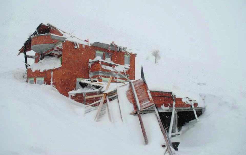
31 VI. NATURAL RISKS Fires Kosovo entered the process of legislation and standards harmonization with those of European Union, whereby is expected the re-structuring and modernization of various sectors of economy. In this context, one of important segments of the government programme is the development of rural areas and reduction of poverty, which means the provision of greater opportunities for increasing incomes for households living in rural areas, small enterprises and municipalities stability. In this context, economic, social and ecological functions of forests are of crucial importance for sustainable development of Kosovo, as well as for improving the quality of life, especially in rural and mountainous areas. Based on these useful functions of forests, Kosovo considers forests as part of the national assets/heritage. Law on Forests confirms this statement: The forest of Kosovo is a national resource. They should be managed to provide a sustainable production and at the same time preserve the biological diversity for the benefit of current and future generations. Forest management should consider other interest of wide public. The law also affirms preventive measures, biodiversity conservation, generations equality principles and the need for implementing the sustainable ecological development. After the war, Kosovo entered a difficult period of transition, where the economic and political systems were re-built to adapt to a completely new environment. This transition period became harder with the complicated political, social and economic situation that affects the functions of all sectors, where even forestry is not exempted. Uncontrolled and unsustainable practices of forest management resulted in stagnation and destruction of forest resources. Kosovo is in the process of signing many international agreements and conventions for forests and environment protection, which will have a great impact in forestry sector. Currently, the only strategic documents for the forestry sector in Kosovo are the Law on Forests of 2003 and Policy and Strategy Paper on Forestry Sector Development and none of them are financed. In May of 2008, the Government of Kosovo commenced the process of drafting the National Policy and Strategy on Forests. The process is based in the recognised principles of development policies through the contributions of local and international experts, as well as other stakeholders. Suggested policy and strategy are in compliance with the forestry legislation and provides for all major decisions which are related to the forestry sector. Statistical data on forest fires Statistics for forest fires are regularly calculated since Climatic changes affected also Kosovo, whereas during 2000, 2004, 2007 and 2012 large areas of forests have been damaged, causing thus a significant loss See Annex, Map no. 5. Hearths of forest fires

32 Table: 13 Forest fires (summer 2007) No. DK of KFA Fires period Burned area in ha Damage value in 1. Prishtina March - October , Mitrovica March - October , Peja March - October ,670, Prizren March - October , Gjilan March - October Ferizaj March - October DMPW March - October Total ,653,028 Ministry of Agriculture, Forestry and Rural Development (MAFRD) is the institution responsible for the implementation of Raising public awareness for protection of forests and forests land project, which in the past was usually financed from Kosovo consolidated budget. The outcomes from second forest inventory indicate that forest area and wood volume remain unchanged since 2013, with an area of 481,000 ha. The purpose of national inventory of Kosovo forests is to provide information on national policy, strategic planning and international reporting for forest resources and climatic changes. 31 Chart no.4. Percentage of areas covered with forests, agricultural land and pastures. Deciduous forests include more than 90% of forest areas. Dominant types of deciduous are oak and beech. Coniferous forests consist 7% of the total forest area, and are dominated by fir (Abies alba), spruce (Picea abies) and pines (Pinus sp.). Forest areas are classified by seedling origin and altitude. More than 60% of areas with naturally germinated woods are in an altitude between meters. According to the National Forest Inventory (NFI) 2012, it is estimated that the total growing stock is million m3, out of which about million m3 with diameter > 7 cm and million m3 with diameter <7 cm.

33 National Forest Inventory (NFI), Forest Management Plans (FMP) and Fis-Kos, in digital geography and database, among numerous attributes, contain also managing classes related to the natural risks, as: areas identified with forest fires, landslide and erosion. 32 Chart no. 5. Likelihood of forest fires spread while preparing the land for spring and autumn planting, according to the Lang Factor, the precipitation to temperature ratio. Risk profile Risk: Forest fires. Potential size (Percentage of community likely to be affected): o Critical. Frequency of occurrence: Highly likely. Areas likely to be affected most: Forests. Seasonal pattern: Spring: May June. Summer: July- September. Autumn: October Probable duration: Relatively short: 3-4 days. Potential speed of onset ( probable amount of warning time): Minimal (or no) warning. Existing warning systems: Forest guards and forestry professional and technical staff, supported by ground vehicles and mass communication system, hunting guards and citizens. Is there any weaknesses/vulnerability analysis? Yes No x
34 Vulnerability from impact in key factors of community Profile Possible consequences Strike rate Residents Deaths, injuries or illness resulting in permanent disability (due to fire impact, smoke, suffocation and visibility). Severe Property Vital infrastructure Objects of particular importance Emergency services Environment In many regions of Kosovo fire captures homes with the associated facilities, stables and community livestock near forests, as well as flora and fauna. Devastation/damage of forests, agricultural lands, meadows and pastures, as well of power supply network. Damage of cultural heritage (mills, water flow channel, bridges, walls, etc.), natural heritage -biodiversity. Damage of response units equipments, terrain vehicles, fire fighting pumps, other equipments, clothes etc. Forest overall damage, flora, fauna and environment likely to be restored. Severe Severe Medium Medium Medium Cultural heritage Devastation and damage of cultural heritage in forest areas. Medium State services Damages of state services and citizens services. Medium Economic damages Devastation/damage of the forests, houses and accompanying facilities, assets, vital infrastructure, etc. Medium 33 Scenario 1. After several months of drought during summer months, coniferous forests in Prizren, Mitrovica and Peja region (Dragash, Prizren, Mitrovicë and Vushtri) were caught on fire, with an expansion tendency. The situation is particularly alarming in the forests of Nj. M. Pashtrik of Prizren. According to preliminary assessments in these two regions forest fire caught on fire an area of ha, with growing stock equivalent of 1,239,120 of all forest categories. With these fires Nj. M. Koritnik II Dragash lost a considerable area of pine culture aged over 200 years. Scenario 2. The situation becomes more severe when Prishtina and Gjilan region report forest fires, in which case an area of ha has caught on fire causing a loss of growing stock (volume) equivalent of In the region of Peja coniferous forests were caught on fire with potential of spreading towards the stables of Rugova villages. Scenario 3 The situation deteriorated further when forest fires spread rapidly in the direction of five mountain villages in Rugovë, Pejë, where currently 18 families with 98 members and a large number of cattle are trapped. The situation is aggravated even more by the wind which blows at 7 m/s. The situation worsens even more after the spread of fire to the mountains of Jezerc (Ferizaj) towards Budakovë (Suharekë), where 30 visitors have remained trapped in the restaurant Trofta (Jezerc).

35 Conclusion Forest fires are the largest forests damagers thus being the major cause of damage to the economy, environment, biodiversity, recreation, health, etc. Forest fires of 2007 have been considered as natural disaster for Kosovo forests and the economy because the fire burned a total area of ha with a loss of growing stock (volume) equivalent of 4,653,029. Kosovo has some watersheds (lakes) which could be used for supplying water aircrafts, with the help of which the forest fires could be very well managed Floods Kosovo is vulnerable to flooding and they happen often 13. Floods in Kosovo in November 2007 affected more than 3500 households, also causing considerable material damages. Almost all municipalities of Kosovo, more or less, are affected by flood risk (see the map no.5.), which are manifested in the form of: Floods after storms in mountain areas, Floods after heavy rains in lowland areas, Floods after the snowmelt followed or not by cold weather. 34 Floods by river basins: Drini i Bardhë: 50 % Ibri: 24 % Lepenci: 20 % Morava e Binçës: 6 % Map no.7. Areas affected by floods. 13 See Annex, Map no. 6. Floods risk.
36 Most considerable damages caused by floods are marked at Drini I Bardh river basin 50,7% (by Master Plan ). Damages caused by floods only from river Drini i Bardhë amounted to 9,7%. Recent floods in Kosovo February, January, April, Current situation: We consider that the factors affecting the intensity of the risks from strong winds may be: considerable distance from the coast, relief with the range of mountains and forests covered with vegetation which can significantly impact on natural curbing, by reducing the intensity of the winds, in particular in regions surrounded by the fields. Despite that, we do consider that the risks caused by the storms cannot be underrated and excluded. Regarding the floods, they occur most frequently during the winter, spring and autumn. Floods in Kosovo are usually as a result of heavy rains where Mayor river flows overflow and flood in urban and rural areas causing considerable damages to infrastructure, private property, agriculture, etc. As a result of rainfall and floods in urban areas because of the old network, insufficient capacity and lack of facilities for wastewater treatment, increase the damage effects even more 14. The duration of any flooding is relatively short (in maximum 3-4 days). 35 Main causes of floods in Kosovo: Rainfall, Uncontrolled constructions in the areas around the rivers, Disposal of solid waste in the rivers, Lack of maintenance of riverbeds and embankments. Deterioration factors: Dense hydrographical network, Slight river gradient, Rainfall intensity and duration, Insufficient depth of riverbeds, Vegetation, Presence of obstacles in water flow. 14 See Annex, Map no.8. floods risk population at municipal level.
37 Possible scenarios: Floods caused by the overflowing streams, Floods caused by the progressive increase of water volume. Consequences: Floods risks in Kosovo caused deaths, injuries, trauma to people, considerable damages to goods, critical infrastructure, objects of special importance, cultural heritage, environment and economy. Flood risk periods: There are two seasonal periods during the year in Kosovo that are characterized by floods: Winter manifested with considerable snowfall, and Spring and autumn manifested with considerable rainfall. Precipitation: Based on historical data over the last ten years from meteorological stations statistics show that January and February during winter season are two months with most snowfall, whereas spring (April-May) and autumn (September-October) with most rainfall. 36 Temperatures: Kosovo s climate is mainly continental with some Mediterranean and alpine influences, summers are hot and winters cold. Extreme temperatures go up to 39/40 C in summer and - 20 C in winter. The landscape in Kosovo is shifting with large thermal variations between hottest and most fresh (chilled) areas. Temperatures usually as a factor less influence in the sensitivity of flooding except perhaps in two quite specific situations. Wind: Kosovo is generally a region not affected with great frequency of winds but they are mostly of medium and low intensity, where the wind direction is mainly from north. Cold and snow waves: average winter temperatures may reach up to 10 C where the snow is more dense in valleys. Drought:. Kosovo is a country with a significant rural area where during the summer there can be longer periods of heat that are usually manifested with considerable lack of rainfalls which then may cause drought, where the lack of water is great.

38 Table 14. Drini i Bardhë river basin. 37

39 Table 15. Ibër and Morava e Binçës River basin. 38
40 Risk profile Risk: Floods. Potential size (Percentage of the community likely to be affected): Critical. Frequency of occurrence: Highly likely. Seasonal pattern: Spring March and April. Autumn October and November. Winter January and February. Areas that likely to be affected: A large share of the territory of Kosovo. Possible duration: 3-4 days. Possible speed of onset (possible time of warning): Minimum warning (or not at all). 6 to 12 hours warning 12 to 24 hours warning. Warning more than 24 hours. Existing warning systems: Hydrometeorological Institute of Kosovo Is there any weakness/vulnerability analysis? Yes No x Vulnerability by impact in key factors of community. Profile Possible consequences Impact scale Residents Deaths, injuries or diseases resulting to permanent disabilities. (because of the impact of wave of water, ruins, and floating Severe solid material). Assets In many regions of Kosovo water flows through the houses and yards of the residents by destroying their property and Severe other stuff. Vital Infrastructure Devastation/damage of water supply, sewerage and energy network, agricultural lands, information technology. Severe Facilities of special Devastation/damage of school buildings, importance governmental buildings, roads, bridges etc. Severe Emergency services Damages of reaction units equipment. Medium Environment Damage/degradation of environment (because of large various flows, sludge and Severe contamination). Cultural heritage Devastation/damage of cultural heritage objects. Severe State services Damage of state services and services to citizens. Medium Economic damages Considerable devastation/damage of houses, properties, vital infrastructure, etc. Severe 39
41 Scenario 1. After several days of autumn rains, the region of Prizren, Peja, Mitrovica and Pristina (Peja, Skenderaj, Vushtrri, Podujevo, Therandë), have been hit by floods. The situation is serious, there are many injured (supposedly over 20 injured), among them old men and children, people remained on rooftops, as well as over 100 people to be evacuated, then flooded homes, killed livestock, roads are covered with silt, considerable damages of water supply and sewerage, contamination of water and soil, as well as damage to the energy system. Scenario 2. Snow thicker than 80 cm that fell a few days in a row in the Republic of Kosovo, has begun to melt due to the high temperatures affected by the consequences of global warming. This fast melting has caused floods covering the entire territory of Kosovo, causing victims (6 dead, over 27 injured) destruction in properties, in roads, water supply, sewerage, energy networks, paralyzing emergency services and other services to citizens. The number of persons to be evacuated for a time 3 to 7 days is over 1550, throughout the territory of the Republic. Conclusion: Natural disasters, in particular floods do not appear at the escalating or catastrophic level thanks to the favourable landscape and climate. Types of floods in Kosovo are instant (torrential) and their duration is short-term (3-4 days). Kosovo is a water-source. Our country possesses Hydrometeorological Institute, which makes weather forecasting and provides meteorological data but lacks an early warning system Earthquakes In the worldwide seismic zoning, Kosovo takes place in Alpine-Mediterranean seismic belt. This seismic belt includes a broad area of contact between the African and the Eurasian lithospheric plates, from the Azores isle to the eastern border of the Mediterranean basin. The concept of plate tectonics is particularly complicated in this area due to the presence of a large number of blocks, and the manner of release of accumulated energy during the process of plastic deformation in most of its part. From the seismological standpoint, the territory of Kosovo represents a region of relatively high seismic activity, which has been hit in the past and could be hit even in the future by very strong indigenous earthquakes, which have shallow hotbeds, generated in the land crust, in maximum km deep underground. Background and current situation Seismicity studies are highly dependent on the available information, the completeness and reliability of data on earthquakes that appear in the earthquake card. For a more seismic risk based assessment, all sources of information on harmful earthquakes in the region have been used, such as earthquake card Albania, Montenegro, Croatia, Serbia, Macedonia, Greece (Thessaloniki), international earthquake Centre (ISC) bulletins, earthquake card for South and Southeast Europe 342 BC AD, EU Commission (342 BC AD), Balkans card (600 BC AD), NEIC - National Seismological Centre USGS ( ), and ANSS - Advanced National Seismic System (USGS).
42 The territory of Kosovo during has been hit by 152 earthquakes of magnitude Richter scale. Out of 89 earthquakes with intensity of 5 magnitude, 37 earthquakes are with intensity of 6 magnitude, 13 earthquakes with intensity 7 magnitude, 10 earthquakes with intensity of 8 magnitude (1 earthquake before the period of 1900) and 3 earthquakes with intensity of 9 magnitude (2 earthquakes before the period of 1900), table 16. Table 16. The intensity and number of earthquakes The intensity of earthquakes in Mercalli MSK-64 scale V VI VII VIII IX Number of earthquakes Map of epicentres of earthquakes 15 is prepared based on the earthquake card and Kosovo Seismological Network for the territory of Kosovo, which includes the data on earthquakes of low intensity, starting from those with 3.8 magnitudes and higher, respectively with intensity V magnitude and higher. These are the most important results and irreplaceable factors which show that the majority of the territory of Kosovo, namely the majority of cities and other settlements are located on the indigenous earthquakes, generated from underground in certain depth of the earth s crust. Most powerful earthquakes occurred in Kosovo As a result of sources from seismological services abovementioned from the region and Kosovo Seismological Network, there are the most completed data for earthquakes that have affected the territory of Kosovo, during the period The earlier data are deficient. Among the most powerful earthquakes that have hit Kosovo are as follows: Earthquake of Prizren, 16 June 1456 (MS=6.0; N, E) with epicentre intensity 8 magnitude (Sulstarova, 2005), 2. Earthquake of Peja, 11 November 1662 (MW=6.0; N; E) with epicentre intensity 8 magnitude (Sulstarova, 2005; Papazachos et al. 2000), 3. Earthquake of Ferizaj, 26 February 1755 (M=6.1; N; E) with epicentre intensity 9 magnitude (Elezaj, 2002), 4. Earthquake of Ferizaj-Viti, 10 August 1921 (ML=6.1; N; E) with epicentre intensity 9 magnitude (Elezaj, 2002), 5. Earthquake of Viti, 15 August May 1921 (MW=5.4; N, E) with epicentre intensity 8 magnitude (SO Skopje, D. Hadzievski), 6. Earthquake of Gjilan, 02 September 1921 (MW = 5.0; N, E) with epicentre intensity 8 magnitude (SO Skopje, D. Hadzievski), 7. Earthquake of Kaçanik-Viti 03 October 1921 (MW = 5.6; N, E) with epicentre intensity 8 magnitude (SO Skopje, D. Hadzievski), 8. Earthquake of Gjakova, 03 September 1922 (MW = 5.3; N, E) with epicentre intensity 71 2 magnitude (SO Skopje, D. Hadzievski), 9. Earthquake of Prizren, 26 September 1945 (MW = 5.0; N, E) with epicentre intensity 7 magnitude (SO Skopje, D. Hadzievski), 15 See annex, Map no. 8. Seismicity (Map of epicentres of earthquakes in the territory of Kosovo, the period )
43 10. Earthquake of Klina, 05 February 1947 (MW = 5.2; N, E with epicentre intensity 8 magnitude (SO Skopje, D. Hadzievski), 11. Earthquake of Kopaonik, 18 May 1980 (MW=5.7; N; E) with epicentre intensity 8 magnitude (Harvard University, SO Skopje, D. Hadzievski), 12. Earthquake of Gjilan, 24 prill 2002 (MW=5.7; N, E), with epicentre intensity 8 magnitude (ISC 2002, Elezaj 2002), 13. Earthquake of Istog, 10 March 2010 (MW = 5.2; N, E) with epicentre intensity 7 magnitude (SIK Sh.Mustafa, 2010), 14. Earthquake of Vushtrri, 18 November 2013 (MW =4,8; 42.9 N; E) with epicentre intensity 61 2 magnitude (SHGJK Sh. Mustafa, 2013). 42 Areas of seismic source in Kosovo The map of seismic sources in Kosovo is prepared based on the epicentre map, surrounding some epicentres areas with border, which in the spatial aspect are indicated the seismic sources. For this reason, this map represents the factual situation and is supported mainly in the period , taking into account also the historical powerful earthquakes. This map determines the position, orientation and the size of seismic sources. With the help of this map we have fixed position, size and orientation of seismic sources from where generate the earthquakes in the territory of Kosovo. This map as will be seen later, will find concrete application in seismic risk assessment of Kosovo. As can be seen from this map, the region of Ferizaj-Viti-Gjilan represents one of the most powerful seismic sources, where occurred strongest native earthquake, the one of 1921 with 6.2 magnitude and epicentre intensity magnitude MSK-IX 64. The region of Peja-Gjakova- Prizren-Dragash represents another seismic source where is registered the earthquake of 1456 with magnitude 6.6 Richter scale (Sulstarova et al., 2001). Also the Kopaonik region is one of the strong areas of seismic sources; this is evidenced by the Earthquake of 1980 with 6.0 magnitudes. These areas of seismic sources in Kosovo, have generated in the past but may also in the future generate strong earthquakes. Seismic Hazard Map 2009 The preparation of seismic hazard map is supported entirely on probability methodologies which consist in quantity assessment of the soil movement in a given place as a result of an earthquake that is likely to occur within a specified interval time. In more concrete terms, the seismic risk in a given country is determined as an expected value of a parameter of soil movement (acceleration, speed, spectral ordinate, macro-seismic intensity, etc.), which with a given probability is not exceeded within a specified period of time. Usually, the programs of seismic risk assessment accept the level of 10 % as an exceeding probability of a threshold given for any parameter of movement of soil within period of 50 years. This corresponds to a repetition of the respective phenomenon once in 475 years. The results are presented in terms of peak ground acceleration (PGA) and the spectrum accelerations (SA) with suppression 5%, for periods of recurrence 95, 475, 975, 2475, 5000 and years, which correspond, respectively, to exceeding probabilities 10% in 10 years, 10%, 5%, 2% and 1% in 50 years, and 1% in 100 years. The assessment was carried out for land-rock conditions, with the average speed of transverse waves in the first 30
44 meters of land VS = 800 m/sec, which correspond to the category A of the land according the classification of Eurocode 8. Thus, the assessment results are in compliance with the standard of Eurocode 8 for seismic zoning and construction codes. Based on the results obtained from the calculations were drafted the seismic hazard maps which characterize the spatial variability of PGA and SA for index suppression 5%, for the periods 0.1 sec, 0.2 sec, 0.3 sec, 0.5 sec, 1.0 sec and 2.0 sec, with exceeding probabilities 10% in 10 years and 10%, 5%, 2%, and 1% in 50 years, as well as 1% in 100 years. These data are based on intensive research of the last 10 years and on an updated database. The database of earthquakes, as well as the historical period for that instrument, is widely improved and converted to a uniform scale, in magnitude. The region of Prishtina, is with average seismic risk, about 0.11 g for repetition period in 475 years. The smaller values of peak acceleration are noticed in the eastern part of the country, in the east of Prishtina to the border with Serbia, which with the 10 % probability in 50 years, the PGA does not exceed the value g. The seismic hazard maps 16 show that the majority of the territory of Kosovo may be considered as an area with average seismic risk (0.08g<PGA<0.22g). The horizontal peak ground acceleration (PGA), with 10% exceeding probability in 50 years (repetition period 475), varies from 0.10g in the north-eastern part of the country up to g north and south of Kosovo. The high-risk area may be considered the area of Kopaonik in the north of Kosovo (PGA= g), area Prizren-Pejë, particularly in the east and southeast of Prizren, near the border of Albania, where PGA, with 10% exceeding probability in 50 years exceeds the level 0.22g, as well as the area of Ferizaj-Viti Gjilan, particularly in direction of Skopje, where PGA varies from g. Based on the Seismic Hazard Map, the territory of Kosovo, especially its western region is characterized by relatively high seismic activity, where in the past have occurred strong earthquakes, which in general are identified as shallow, km. The main areas of seismic sources in Kosovo are as follows: (KGS, Sesmic Division 17 ). 1. Seismic area Prizren-Pejë, 2. Seismic area Ferizaj-Viti-Gjilan, 3. Seismic area of Kopaonik. 43 Based on the Seismic Hazard Map can be seen that the period of repeating earthquakes with a magnitude MW=5.0, 5.5, 6.0 and 6.5 are respectively 3.1, 14.2, 69.8 and years, whereas an earthquake with MW=6.7 is repeated on an average every 2446 years. From the probability view, every year in Kosovo is expected an earthquake with a magnitude up to 5.0 with probability 27.8%, and every 50 years is expected an earthquake with MW=6.0 with probability 51.2%, and every century, an earthquake with a magnitude up to 6.0 with probability 76.2%. 16 See Annex, Map no.9. Seismic risk areas in Kosovo 17 Seismological Network of the Republic of Kosovo is established in 2008, whereby started the study work of earthquakes.
45 During , the territory of Kosovo was hit third times with Mag Richter scale. 1. Earthquake of Gjilan , Mag.5.7, intensity VIII1/2. 2. Earthquake of Istog , Mag.5.2, intensity VII. 3. Earthquake of Vushtrri , Mag.4.8, intensity VI1\2. Seismic hazard and current probability maps are calculated for ground-rock conditions. However, the local conditions of the ground within a few hundred meters can cause such variations in seismic risk, which are higher than the variations nationwide. Most of urban regions are located along the river valleys, on loamy deposits. The movement of the ground in such deposits is generally much greater than the rocky strip, due to local effects on signal amplitude and its frequency content, as well as the duration of movement of the ground. The seismic hazard maps are updated with the aim of including the latest achievements of the science of seismology at the local, regional and global level. 44 Deterioration factors Reshjet atmosferike, erërat dhe ndryshimi i temperaturave janë faktor përkeqësues, si në mundësinë e dridhjeve të mëvonshme, po ashtu edhe në përkeqësimin dhe krijimin e kushteve të vështirësuara për reagim dhe përkujdesje për banorët goditur. Ndërtimi pa kritere dhe cilësia jo adekuate e strukturave ndërtimore në Kosovë i bënë të ndjeshme vendbanimet e saj. Risk flows: Collapsing of high residential and public buildings, Damages to infrastructure and transport, Deterioration in the environment (water flow, landslide), Secondary effects (fires, collapsing, leaking sewage and toxic products, etc.).
46 Risk profile Risk: Earthquakes. Potential size (Percentage of community likely to be affected): Critical Seasonal pattern: Frequency of occurrence: Likely. Areas likely to be affected: The likelihood of recurrence of earthquakes of magnitude MW = 5.0, 5.5, 6.0 and 6.5, respectively 3.1, 14.2, 69.8 and years; an earthquake of 6.7 MW = reoccurs in average every 2446 years. From the probability viewpoint, every year in Kosovo can be expected an earthquake with magnitude up to 5.0 with 27.8% probability; every 50 years is expected an earthquake with 6.0 MW with 51.2% probability; every century, with 76.2% probability is expected a 6.0 magnitude earthquake. - Seismic area Prizren-Pejë, - Seismic area Ferizaj-Viti-Gjilan, - Seismic area of Kopaonik. Possible duration: Instant (2-10 Sec.). Potential speed of onset (possible warning): No warning. Existing warning systems: None. 45 Is there any weakness/vulnerability analysis? o o Yes No Vulnerability to impact in key factors of community Profile Possible consequences Impact scale Residents Tens of deaths, hundreds of serious injuries and trauma. Severe Property Destruction/damage of public and private property. Severe Vital infrastructure Facilities of particular importance Destruction/damage of the road network, water and wastewater, energy, telecommunications, etc. Destruction/damage of administration buildings, banks, offices, schools, government buildings, shops, shopping malls, restaurants, etc. Severe Severe Economic damage Destruction/damage of public and private property. Severe Environment Cultural heritage Destruction/damage of environment due to various leaks, gas and smoke, contamination of air, surface and underground water, fertile soil, food and animals.. Severe Low State services Damage to state services and services for citizens. Medium Emergency services Damage to assets and emergency response equipment services. Medium
47 46 Scenario 1. An earthquake of 5.5 magnitude of Richter scale hit a large part of the region of Mitrovica, North of Kosovo (Kopaonik), for two consecutive days, 3 and 4 December and in a severe manner impacted also the residents, cities, villages, streets and factories by causing the following consequences: over 20 dead persons, hundreds injured, hundreds trapped and disappeared, whereas other damages are as follows: many residential and public buildings collapsed, damages in infrastructure and transport, environmental disorders (water flow, landslide). Secondary effects of this disaster are (fires, collapses, leaking sewage and toxic products, etc). It is suspected the dam in Ujman (Gazivoda) is cracked, and in case it dam failure it will endanger the entire region of Mitrovica with a devastating disaster. Scenario 2. Earthquake of 6.5 magnitude of Richter scale, on 5 and 6 December hit the east, north, west and south of Kosovo. The earthquake has caused hundreds of deaths, thousands injured, many people missing and trapped as well as many collapsed facilities such as residential houses, critical infrastructure, roads and paralyzed the entire life and services of the Republic of Kosovo. Conclusion In the entire territory of the Republic of Kosovo there is the risk of earthquakes. Considering that the most endangered areas are the seismic area Prizren-Pejë, Seismic area Ferizaj-Viti- Gjilan, Seismic area of Kopaonik, where lives nearly the half of the population of Kosovo. These areas and the number of population living there may have critical consequences during earthquake, such as: deaths and injuries, evacuations, facility collapsing, traffic interruption, road blocking. Also, the number of the vulnerabilities will be increased as a consequence of secondary risks such as: explosions, fires, floods and epidemics. The seismic risk assessment in Kosovo, establishes the basis for a modern policy in mitigating the consequences from earthquakes, whereas the results obtained can be used by national and local authorities, as well as from organizations and individuals interested in territorial planning and administration, design of earthquake resistant structures, etc, thus by enabling the integration of up-to-date level of understanding and responding to the changing needs of the community of users. Recommendation In order to improve the results on seismic risk, we recommend: - Reassessment of historical magnitude of earthquakes occurring in the territory of Kosovo. - An seismicity parameters based assessment, by improving the database of earthquakes occurred in Kosovo and neighbouring regions. - A regional tectonic pattern that links the seismicity observed with active tectonic breaks, their decay mechanism, etc. - More accurate models for forecasting parameters of soil liquefaction, based on regional records of strong quakes in Kosovo and neighbouring countries. - Development of a multi-year research program to further review and clarify the hypo-centres of earthquakes in Kosovo.
48 Pre-earthquake measures to be taken in the regions with seismic activity: - Processing of the seismic hazard map of the country based on the seismic data for different levels of seismic rick acceptable for the planning, designing and construction. - Processing of micro-zoning seismic maps for important urban areas Processing of a seismic hazard map. - Drafting of laws and regulations for the measures against large-scale earthquakes. - Expansion and modernization of the network with seismographs and accelerographs Landslides Based on the lithological, tectonic, morphological, climatic, hydrologic structure of land, it can be concluded that many parts of the territory of Kosovo are covered by a number of eczodynamic processes, mainly represented by landslides terrain. In the complex of these phenomena, an important role in modelling the landscape of Kosovo play also the landslides in different measures, which in some cases cross in strong demolitions, especially during tectonic slopes. The landslides during the tectonic contacts of magmatic rocks with those terrigenous are highly developed, thus during the destruction phase, including mainly colluvial-prolluvial and deluvial materials of alienation crust. These materials collected during the slopes of severances and those complexes during the morpho-tectonik and morpho-climatic evolution are characterized by an unsustainable situation, exacerbated by numerous water leaks due to their nondescript scale. The phenomena of terrain instability, which mainly appear in the format of landslides and demolition, most expressed are in the: Mountains of Kopaonik, Rogozna, Bjeshkëve të Nemura, Sharr Mountain, central and eastern mountains of Kosovo. We encounter the phenomena of landslides 19 also in the lower part of the ground in the areas of neogene basins (Dukagjin, Kosovo, Llap, Drenica, Morava e Binqes) and other parts. 47 Conclusion: Based on up-to-date geological-engineering research of the terrain may be concluded that the majority of unstable areas are related to the geomorphologic terrain structure on the basis of which are constructed the maps with geo-potential areas of risk. 18 Micro-zoning is the preferred method to assess local soil amplification in view of frequency. The highest level of studies to understand the local effects are 3- dimensional geological patterns of geophysics and numerical pattern of the soil movement amplification. 19 See annex, Map no 10. Landslide areas.
49 Risk: Landslides. Risk profile Potential size (Percentage of community likely to be affected): Critical. Seasonal pattern: Frequency of occurrence: Likely. Spring March and April. Autumn October, November and December. Winter January and February. Areas likely to be affected the most: unstable areas related to geomorphologic structure of terrain, steepness of rock layers making up the location, vegetation, seasonal and permanent waters. Possible duration: Relatively short 3-4 days; Relatively long several months; Tens of years long with several breaks of movement of rock masses; Potential speed of onset (possible warning): Minimum warning (or at all). 6 to 12 hours warning. 12 to 24 hours warning. Warning more than 24 hours. Existing warning systems: Integrated number Is there any weakness/vulnerability analysis? Yes X No Vulnerability as a result of impact in key factors of the community. Profile Possible consequences Impact scale Residents Assets Vital Infrastructure Facilities of special importance Deaths, injuries or diseases resulting to permanent disabilities. Devastation/damage of residential buildings, water supply and sewerage network, etc. Destruction / damage of road infrastructure, energy and telecommunication network, etc. Devastation/damage of school buildings, FMC, government building, etc. Severe Severe Severe Severe Emergency services Damages of reaction units equipment.. Medium Environment Degradation of environment Severe Cultural heritage Devastation/damage of worshipping objects. Severe State services Economic damages Damage of state services and services to citizens. Considerable devastation/damage of houses, properties, vital infrastructure, etc. Medium Severe
50 Scenario 1. High level of precipitation during the seasons: autumn - winter and spring of 2013, the village Crmjan / Djakovica is affected in several places by land slide. On this occasion, considerable damages were caused to agricultural lands, roads and water supply. In case of continuation of rainfall in longer periods, the chances of reactivation of landslides are high by endangering even the destruction of houses. Losses of people s lives, livestock and poultry are not excluded as well. Scenario 2. Landslide in village Brod, Municipality of Shtërpce, reactivated in spring of 2007 thus destroying completely 70 % of the houses of this village, auxiliary facilities such as stables, garages, energy network, school, health clinic facility. Around 36 families are affected by landslide and they are also endangered. Scenario 3. Kaçanik Hani i Elezit highway affected by the phenomenon of rock masses sliding endangering a quite busy traffic in this road. The direct attack potential to cause damages in people who are using this highway to travel by bus or train are real, because in rainy seasons, this phenomena can occur suddenly. Damages, except on people, will also affect the state economy, because in such certain situations, the transportation of goods from Macedonia will get blocked for longer periods. Conclusions: The number of families at risk is large. Based on the fact that landslides are active, the situation may be alarming. If rainfall continue for a longer period, the situation will deteriorate even more. 49 Rekomandime: Because of the possible landslide and permanent risk posed, it is recommended: - to study geolog-geomechanical of construction lands. -to authorize institutions in cooperation with Municipal assemblies to draft, implement and manage landslide prevention and management. -to provide maps (aerial recording and cadastral map of village Brod) by Kosovo Cadastral Agency, as well as to conduct geodetic records of the relevant terrain. -to allocate funds from Kosovo budget to undertake measures for repairing damages and application of adequate of the area rehabilitation methods. -implementation and management of Inhabitants Dislocation/Relocation Strategy.
51 6.5. Rolling of rock masses in the territory of Kosovo These are rock characteristics for hard and relatively hard rocks. They are characterized by falling pieces and blocks by rolling at the edge of the slope thus forming a cone of products. They arise mainly as a result of the alienation process in high inclined slopes or under the influence of different explosions, especially in cracked rocks. As the main factor leading to loss of internal bonding of the massive are cracks of alienation, the development of plant roots in the cracks, rapid temperature changes that lead to the freezing and melting of water in different rock cracks, etc. The size of rock pieces largely depends on the type of the rock and its crack ability coefficient. This phenomenon often poses a permanent threat for people and material goods, and traffic risks. Rolling of rock masses: - along the road Prishtina Skopje ( Kaçanik - Hani i Elezit); - in Peja Region (Rugova Gorge); - in the territory of Bjeshkët e Nemura ; - along the valley of the Ibar river (Northern Part of Kosovo); - the region of Shala e Bajgorës, and - in the area of Grebnik, outskirt of Çupevë e Epërme village. Based on so studies conducted far, it is managed the creation of a map, which presents potential areas where might occur the phenomena of rolling of rock masses Abandoned surface mines Rapid development of the road infrastructure and construction industry has posed the great need of opening more surface mines (quarries) to use construction materials such as hard rocks, sand and gravel, etc. A number of them, for different reasons, have concluded the exploitation of these materials by leaving behind degradation of nature and environment in the areas of their operation. So far in these locations 21 we did not have any case of rehabilitation and bonification of the devastated nature. This fact has pushed local institutions to take the necessary steps, in one way or the other, to oblige legitimate beneficiaries of these mining to return to the previous state, while avoiding the risk possibilities for the communities living in that location. Legal infrastructure obliges users of these natural resources to undertake bonification measures after the end of exploitative activity. 20 See annex, Map no. 11. Areas with rolling rocks 21 See annex, Map no. 12. Locations of surface mines
52 Hazard Profile Hazard: Abandoned surface and underground mines. Potential magnitude (percentage of the jurisdiction that can be affected): Critical. Frequency of occurrence: Possible Seasonal pattern: Throughout the year. The areas that can be affected the most: Cities and villages where the mines are located. Potential duration: Until their rehabilitation. Potential speed of onset ( potential warning time): Minimal (or no) warning 6 to 12 hours warning. Existing warning systems: Integrated number 112. Complete Vulnerability Analysis? 12 to 24 hours warning. More than 24 hours warning. Yes No X Vulnerability from hits at key factors of community Profile Possible Consequences Impact grade Inhabitants Deaths, injuries resulting in permanent disability. Severe Property Loss of property (tools and equipment). Severe Vital infrastructure Destruction/damage of the road, electricity, water, sewage networks, etc. Severe Objects of particular importance Emergency services Damaging of tools and equipment for emergency response services. Medium 51 Environment Environment degradation. Severe Cultural heritage State services Economic damages Damage/destruction of tools and equipment (public and private). Severe Scenario 1 After completing the exploitation of ore in surface and underground mines, no sanitation measures were undertaken. As a result of the condition of these facilities often occurred damages to people and various properties of communities living in these environments. Scenario 2 Horizontal and vertical mining works of large dimensions and significant depth that are still open, without protection have caused people to fall into them. In Dubovc a young man has fallen into a hole in tens of meters deep and after a three-day stay in, he has suffered serious body injuries and mental consequences, and in a short time afterwards died. The same mine was rehabilitated at a low cost, leaving the possibility of reopening it at any time. Surface barriers are not fenced, thus the big hole created during exploitation has not been covered and falling of pedestrians is highly potential.
53 Conclusion: Since the MED (Ministry of Economic Development) has conducted the study of identification of these objects, which has also carried out the rehabilitation and bonification of one of these mines (Dubovc), I recommend that such a practice should continue in the rest of Kosovo Other natural risks As natural phenomena, natural disasters as meteorological phenomenon are influenced by the seismic activities and it is difficult to determine the location of the occurrence. They might affect one or more parts (regions) of the country even in the whole country. Thunderstorms Thunderstorms are natural phenomena manifested with furious and powerful winds, with heavy atmospheric precipitations which suddenly start and which do not last long. Mainly occur in spring and autumn as a result of numerous weather changes (atmospheric pressure, temperature, humidity and air density). Storms Storms are natural phenomena which are manifested with strong winds which stretch from several hundred meters up to tens of kilometres and they last from a few minutes up to several hours. They appear as a result of the instability of the weather conditions. Lately, this phenomenon is often occurring in Kosovo, especially in the period from June to September, corresponding with the increase of temperatures. The most affected towns are the city of Shtime and Istog. The effects of these natural disasters are numerous, such as: Damaging of houses and roofs, Damaging and partial destruction of electricity and telephone networks, Relocation/throwing of various objects (containers, greenhouses, pulling of trees, etc.), Deregulation of transportation (road, rail and air), Floods and pollution of surface and underground waters. Consequences Deaths and injuries from collisions (different objects, electric cables and poles, objects falling from the heights), Traffic accidents, Reduction and disruption of socio-economic activities, Flooding, Damaging and destruction of agricultural crops, ornamental trees, etc. Frosts and frosted rains Frost is a natural phenomenon manifested by low temperature air currents, which appear as a thin layer of ice (covering the ground) as a result of freezing of the water, humidity and fog.
54 Types of frosts: Frosts from the rains: are easily predictable, they appear when it rains and when temperatures drop below minus o C or the temperatures drop down fast, while the roads are still wet. These frosts are frequent phenomena that can appear throughout our country. Frosts from condensation: In this case the phenomenon is more complex and much more limited (in the shaded areas, under the trees...). We know that air can hold only a certain amount of water vapour. Therefore, the lower the temperature is, the air can hold less vapour. Frosted rains appear when rains reach the ground in the shape of water drops and freeze when they come in contact with the frozen surface. Prediction of such rains with frost is extremely difficult. Consequences of frosts and frosted rains are mainly traffic disorders or accidents. Droughts This phenomenon occurs when winter precipitations are extremely weak when underground water resources are scarce, surface reservoirs (lakes) are also under minimal level of filling. Supplying of population with water from the reserves of accumulating lakes, which depend on precipitation. Kosovo is a source of waters, but accumulates in a very limited extent (fulfils its needs with water reserves). During the summer season high temperatures may disorder greatly the comfort of normal life in Kosovo, in particular urban areas. This disorder significantly affects mainly in the health of elderly, children, chronically ill people, pregnant women and other vulnerable groups. As a result of droughts, it is caused air pollution, decrease of the quality of drinking water, emerging of epidemics, and it may cause damaging of the ecosystem. 53 Waves of cold and the snow: The wave of cold is a natural phenomenon manifested by low temperatures, reaching the value from -10 o C or below, or that reaches rapidly the negative values lower than -5 o C. This is a seasonal phenomenon and is manifested in winter season months (December- February) and includes the territory of the Republic of Kosovo. Snow as one of the atmospheric precipitations fills the surface and underground water reserves, but also causes difficulties and damages. Heavy precipitations and layering of snow reduces the visibility, hinders the movement of vehicles and citizens, burdens telecommunication networks, transportation and distribution of electricity, creates avalanches, and often, as the consequence of fast melting of snow in the spring season (March-April) causes flooding. Conclusion: All these natural phenomena and precipitations, occurring in Kosovo pose risks that can result in high number of casualties and severe material damages. It is a necessity and a need for the relevant state institutions to allocate a significant portion of assets in undertaking preventive measures and strengthening the response capabilities, which would enable risk reduction and rehabilitation of consequences.
55 VII. RISKS FROM OTHER DISASTERS 7.1. Landfills of the mining industry 54 Kosovo and its surrounding areas have faced great and persistent risks of environmental pollution by expansive development of the industry. On the other hand, environmentalists from day to day, through international conventions and rigorous environmental standards, force the industry in general, and mines in particular, to minimize wastes and flows of hazardous materials in order to enhance the protection and effectiveness to achieve clean and healthy environment for all. Kosovo has inherited a large number of environmental problems, accumulated for decades as a consequence of uncontrolled usage of natural resources and mining, industrial production, associated with a high degree of pollution, which poses a continuous risk for the surrounding community, and for Kosovo in general. The exploitation activity of underground and surface mineral resources leaves wide areas contaminated with acidic water, heavy metals, especially with Pb, Zn, Cd, As, Hg, etc. After a field study throughout the territory of Kosovo, a significant number of different landfills have been identified 22, such as wastes from the mining industry, which today pose a permanent risk for Kosovo. Locations of these landfills are located in the municipality of Mitrovica, Zveçan, Graçanica, Novo Brdo, Obiliç, Lipjan, Gjakova, Leposaviç and Staritrg. The data below show information on the location of landfills. Landfills in north of Kosovo: Zveçan, Landfill near Iber river close to the Pb Smelter in Zveçan, Wastes and industrial waste landfill in Zveçan, Gornje Pole, Wastes and industrial waste landfill in Zveçan,, Waste smelting plant in Zveçan. 22 See annex, Map no. 13. Mining landfills in Kosovo (observation map).
56 Table 17. Coordination of all mining landfills in Kosovo No Name Location-Place Surface in Ha Y X Z 1 Mining landfill Kishnica Mining landfill Badoc Mining landfill Artana Mining landfill Artana Mining landfill Kelmend Zveçan x 8 Mining landfill Zveçan x 9 Radioactive material repository First Tunnel x 10 Radioactive material PIM Laboratory x 18 Mining landfill Magure, Lipjan Ash landfill KEK Obiliç x 21 Ash landfill KEK Obiliç x 23 Feronikel mining landfill Çikatovë, Drenas x 24 Mining landfill Devë, Gjakovë x 27 Mining landfill Leposaviq x 28 Trepça Industrial Park Mitrovica x Hazard Profile 55 Hazard: Mining landfills and mining industry landfills. Potential magnitude (percentage of the jurisdiction that can be affected): Critical. Frequency of occurrence: Possible. Seasonal model: Throughout the year. Areas likely to be affected most: Cities and settlements where landfills are located. Probable duration: Until their complete rehabilitation. Potential Speed of Onset (probable amount of warning time): Minimal (or no) warning. 6 to 12 hours warning. 12 to 24 hours warning. More than 24 hours warning. Existing Warning Systems: Integrated number 112. Is there a vulnerability analysis? Yes No x
57 Vulnerability from hits at the key factors of community Profile Possible Consequences Impact grade Inhabitants Property Vital infrastructure Objects of particular importance Emergency services Deaths and injuries, and other health Severe consequences Destruction and damaging of agriculture Severe lands Destruction and damage of the road, electricity and telecommunication Severe networks, school buildings, FMCs, etc. Damage of tools and equipment for Medium emergency response services Environment Environment degradation. Severe Cultural heritage Damage of cultural heritage objects Medium State services Damage to state services and services for citizens Medium Economic damages Severe destruction and damage to flora and fauna Severe Scenario 1 56 Large space occupied by waste from mining and mineral industry, hundreds of hectares. Mineral and chemical composition directly affects the surrounding flora and fauna, health of inhabitants living within the radius of influence from landfill, discharging into the nearest rivers. Acidity created as a result of improper management of stored material. In drought periods and with strong winds, solid waste is moved to remote distances thus contaminating a wider environment. Scenario 2 Geological composition of the exploitation area, mineralogical composition of the ore exploited in contact with ground and atmospheric waters creates high acidity, that during transport to the landfill destroys the technology, in and around the surrounding area of flora and fauna where the waste landfill is located. Total destruction of all living organisms in the water as a result of waste landfill impact, i.e. Landfills in Marec has destroyed in entirety the flora and fauna of the Marec River, tens of kilometres were destroyed. Recommendations: 1. Conducting a geologic economic study of all mining residues. 2. Urgent intervention for their rehabilitation. 3. Consider the possibility of re-enrichment with modern technology. 4. Perform treatment of atmospheric waters and of waters flowing through the landfills in order to bring the ph into normal limits.
58 7.2. Setbacks and steep slope zones (Geo-hazards in active and abandoned mines) Exploitation of minerals in Kosovo has a long tradition. For many years it has occupied the most important role in economic development. Deposits in the territory of Kosovo are spread throughout the territory of Kosovo. The most significant deposits of lead and zinc are in the metalogenic region of Kopaonik (Albaniku), respectively in the Trepça ore field, which stretches in the north-eastern part of Kosovo, ranging from Kopaonik (Albaniku) to Gllamë. Appearances and deposits of iron - nickel in Kosovo, which extend from Ivanja, near Kaçanik in south and stretches all the way to Vërbovc in north. Locations where most important deposits of Fe-Ni ore appear are: Golesh massif, Dobroshevc massif and southeast (SE) Kopaonik. Bauxite-carrying region is part of the ultra-basic rocks massif of Rrahovec. Deposits and appearances of bauxite stretch on mountain Gremnik, 5 to 10 km southeast of Klina. Chrome deposits are located in the following locations in Kosovo: the ultra-basic massif of Gjakova, Rrahovec, Luboten, Brezovica, Golesh, Dobroshevc, etc. This brief historical overview of research and exploitation works through long periods has caused certain changes in the relief where these activities occur. They are still evident and pose a permanent risk to the surrounding community 23. On the other hand some of them due to the cessation of mining activity have been destroyed, ruined, whereas vertical mining works in the above mentioned areas are also often causes of damages to the people as well as to their properties. From the mineral exploitation activity by various methods ranging from the most primitive to those with more sophisticated technology, certain areas in the entire territory of Kosovo carries exploitations that cannot be seen due to developed vegetation. Considering all these facts, experts of different fields of mining, apart from existing materials, conducted visits in almost all these areas, making the following description of their condition: Location, Brief description of geological composition of a narrow area, Mining works, Methods of exploitation. Vertical cutting, which then gives us a clear overview on their extent 57 Area of Shala e Bajgores -Mining works in Gumnishtë Area of interest GUMNISHTË stretches in the territory of municipalities of Mitrovica and Vushtrri, above the sea level between 600 to 1300 m and covers an area of 29,172 km². Vertical and horizontal wells in this area are the best evidence for the exploitation of the ore in these areas, which also pose a great danger to residents living within the area in question. 23 See annex, Map no.14. Geo-hazards


59 Very old and uncovered vertical mining works in Gumnishtë Mining works in Picel-Bajgora 58 Mining works in Karaçë, Vushtrri The researched area is located near the village Karaçë, which is located north of Vushtrri at a distance of 6 km and SE of Stanterg at a distance of 10 km. Karaçë area is located in the crystallized limestone, which appear as a huge horizon of a series of Velesh schist. Mining operations in this inhabited area, often posed a danger for life and for their livestock (according to the stories of the local residents - Karaçë). - Mines in ore field of Artana, - Ore field Badovc Hajvali Kishnicë, - Surface Mining Kisnica, - Area of Zhegovc Mountain/Gjilan, - Mining works in Visoqë, - Underground coal mine in Babush i Muhaxherëve Failure of dams These risks can be a threat, according to the type, size, concentration of hazardous materials, and distance of the object either where the hazardous materials are produced, transferred or stored. Considering that Republic of Kosovo has a large concentration of gas stations, and the rapid economic development that will follow due to being a new country, and the high density of inhabitants per km², a disaster is likely to occur. Dam, is in most cases an artificial structure which in general transforms a valley into a water reservoir. Dams mainly serve to regulate the water flow, supplying cities with water, irrigate agricultural crops and to produce electricity. Risk of rapid and unpredictable failure is extremely rare. The situation may occur as a result of rapid evolution of structural damage. In the event of partial or complete dam failure, it would be created a wave of devastating floods in this area and in particular in the area of one quarter-hour (the area in which the wave would make less than quarter-hour to reach).
60 Background Winter of Freezing of the surface of Lake Batllava has pressured the tower of the lake to not receive water, the ice pressured the tower and thus was endangered the complete disruption of supply of drinking water for the city of Prishtina. Places where this risk is likely to happen are: Badovci with 2.57 km², Batllava with 3.27 km², Ujmani with 9.10 km², Radoniq with 5.96 km² and Përlepnica with 1.8 km². Dam failure/aggravating factors Rapid increase of the water level due to rain; Powerful earthquakes; Inadequate maintenance and the human factor; Risk flow Below are emphasized 3 main risks of flows: Complete or partial dam failure, Overflow due to accumulation of a large quantity of water, Deliberate emptying water in case of overload. Consequences In the event of a dam failure, the consequences could be disastrous for people, goods and environment. 59 Hazard profile Hazard: Dam failure. Potential Magnitude (percentage of the jurisdiction that can be affected): Critical. Frequency of Occurrence: Possible. Seasonal pattern: Throughout the year. Areas likely to be affected most: Prishtina, Mitrovica, Podujeva, Gjakova and Gjilan. Probable Duration: Hours/Days. Potential Speed of Onset ( probable amount of warning time): Without warning or minimal warning. Existing warning systems: None. Complete Vulnerability Analysis? Yes No x
61 Vulnerability of key factors of community being affected Profile Possible Consequences Impact grade Inhabitants Death / serious injury and massive flooding. Severe Wealth Destruction / damage of private and public wealth. Severe Critical infrastructure Destruction / damage to the electrical grid, telecommunication, water supply, sewage, road infrastructure, etc. Severe Objects of particular Destruction / damage to schools, hospitals, food, importance warehouses, substations, etc. Severe Economic damage Total destruction/damage of the impacted area. Severe Environment Destruction/damage to the environment. Severe Cultural heritage Destruction/damage to cultural heritage, objects and archaeology. Severe State service Damage/blockade of state infrastructure. Severe Emergency services Emergency response equipment services Severe Possible scenarios It is possible to simulate the fallout of dam and make the pattern of impacting waves in order to determine the level of the river at the dam outfall. This enables localization of settlements that would be flooded, warning and the alarm. Such a scenario must be exercised, studied and tested in order to forecast the consequences for: 60 Population, Residential facilities, Public facilities (administration, schools, emergency response services, etc.), Transport network and vital supplies, Economy, Environment, Cultural Heritage.
62 VIII. RISKS IN CRITICAL INFRASTRUCTURE This infrastructure encompasses energy capacity, processing of oil and its products, transportation and distribution, communications and information technology (telecommunications, electronic media, software, hardware and network, especially the Internet), finances (banks, insurance and investment) health facilities (hospitals, blood transfusion institutions, laboratories and pharmacies, research and development, emergency services). Food (production, distribution and food industry), water (dams, reservoirs, processing and network). Airports, road and rail transport, production, storage and transport of hazardous materials (chemical, biological, radiological and nuclear), government administration, critical services, facilities, information networks, locations, and essential national resources and facilities). Critical infrastructure is owned by the state, local and regional units, legal persons who are founders of the local or regional units of government as well as private property. Protection of Critical Infrastructure which implies the common name for the network and crucial systems to the functioning of life of the population, in case of damage or destruction, may cause fluctuation and crises, and could affect all the Republic of Kosovo or certain regions. Between this diverse infrastructure there is a mutual connection and interdependence, so that the problems in a particular segment on a part of this infrastructure or network, could easily spread into systems and other networks, leading to the termination of activities or problems, therefore in combination will cause the loss of lives and long-term effects on the system of governance, economy, public health, national security, public confidence, as well as have other consequences for society as a whole or partial. Therefore, the risk assessment of critical infrastructure is necessary in all areas, from legal entities, local governments, up to the national level, in order to assess the vulnerability of the Republic of Kosovo, due to the critical Balkan and European infrastructure dependence, as well as of other countries. In this case, it is assessed the degree of risk and vulnerability of the particular infrastructure, from all possible risks, and the risks for the provision of services, provided by this infrastructure. Networks and systems that constitute critical infrastructure and are connected with the country they are located, are subject to the same risks threatening that country, namely the locality of the city, municipality, region or area of the Republic of Kosovo in general. Therefore, when assessing the risk of any threat in a given country, must be kept in mind the risk to critical infrastructure, in order to assess the possibility and capability of providing necessary items and services to remedy the consequences, protection and rescue inhabitants, as well as normalization and functioning of the impacted settlement. It is possible that these risks to critical infrastructure are sometimes unnoticeable, since they depend on other intermediary and invisible systems, however, in the assessment process, must be foreseen the measures for their reduction to acceptable risks. Because of the complexity of the assessment of risks to critical infrastructure, institutions should be obliged that separately for each type of infrastructure and risks according to their emergency responsibilities, to evaluate the risks in this infrastructure. In this assessment must be planned the prevention activities, elimination or reducing the risks that may affect the critical infrastructure or its services. 61
63 8.1 Information Technology After the war in Kosovo, it was invested more in mobile telephony in comparison to fixed telephony, where were made only few investments. Regarding fixed telephony, were repaired only the damages that were made during the war in the PTT building in Prishtina. Today there are around 120,000 fixed telephony subscribers. Kosovo is ranked next to last in Balkans, regarding the number of fixed telephony subscribers in 100 inhabitants. In rural parts of Kosovo, with the exception of a small number of rural settlements, there is no fixed telephony network. In comparison to this, the situation is better in mobile telephony. In the Balkans, only Croatia has more mobile phone users per 100 inhabitants. Development of Internet network is still in its initial stage although it has made significant progress. 62 Telecommunication The information and communication technology system is extended to all central government institutions, agencies and local institutions. From this system benefit all central and local government institutions, businesses and citizens of the Republic of Kosovo. In the government network infrastructure are connected more than 350 different institutions, the technology infrastructure network of government consists of microwave and optical network. All government institutions are connected to the government network either through microwave or optical network, in some cases an institution possesses two connections at the same time, the connection through optical fibres serves as the primary connection and microwave connection serves as a secondary one. Optical and microwave network system of government possesses over 1000 active devices such as various Routers, Switches and Antennas spread throughout the territory of Republic of Kosovo. Government network infrastructure enables the operation of many different applications which serve to the central institutions, local institutions and citizens of the Republic of Kosovo. Some of most important applications (services) functioning through the government network infrastructure are: Civil Registry System, Passports System, ID System, Driving Licenses System, Property Tax System, Free Balance Payment System, Intranet and register system in all municipalities of Kosovo, governmental system, VoIP phone system, Internet, Business Registration System, Cadastre System, e-pasuria System, Electronic Archive System, Work Attendance System, Human Resources Management Information System etc. Microwave network Microwave network of government is spread to the entire territory of the Republic of Kosovo in which are connected all municipalities in Kosovo. This network is built based on standards by using high strategic points to cover the entire territory of Republic of Kosovo. In order to cover the entire territory of Republic of Kosovo, the microwave network of government uses 17 strategic transmission points such as: Berisha, Zym, Cernusha, Zatriq, Qycavicë, Cvilen, Maja e Gjelbër, Bratilloc, Gajre, Bukiq, Gërmi etc. Within these strategic points are also the towers which are used along with the accompanying infrastructure which enable the operation of microwave network. Government microwave network comprises of more than 130 microwave links (260 antennas) which serve for connecting various central and local institutions to the government network 24. Administration and maintenance of 24 See Annex, Map No. 15. Microwave network.
64 government microwave network is carried out by the Agency for Information Society, namely Directorate for Network and Telecommunication. Optical network The governmental network is extended throughout the territory of Kosovo by optical fibres and serves as the primary connection to government institutions which are connected to the network through optical fibres. So far, in the government network, through optical fibres, are connected all central institutions (ministries and agencies), as well as the majority of municipalities in Kosovo. In addition, even the governmental optical network is managed and maintained by the Agency for Information Society namely Directorate for Network and Telecommunication 25. Telephone system in Institutions of the Republic of Kosovo The fixed telephony system in the institutions of Republic of Kosovo is developed and functional in every institution, either in central or local level. Functionality and ways of communication through telephone system starting from the Presidency, the Prime Minister, ministries, etc., is allowed in the form of government telephone service (centrex), which is a service that has no budgetary implications. Communication through civil servants in all institutions is carried out by the Governmental Agency for Information Society, namely Directorate for Network and Telecommunication. The analogue telephone system in institutions where we started to function after the war in the form of centrex is extended in approximately 60% in analogue system through PTK. Therefore, ASHI as responsible for the functioning of fixed telephony in all institutions, in order to increase communication capacities among civil servants, has planned implementation of the project of government telephone system VoIP. In addition to the central institutions, the digital telephone system has begun to function in local institutions also. When speaking about VoIP telephone system, it should be noted that such VoIP telephone system is enabled through government Internet network, without needing a separate telephone network. The system works through LAN network using IP for communication whereby is enabled sufficient and easy traffic between clients. With functioning of such digital telephone system (VoIP), it is provided communication of offices in the remote areas (Civil Status Offices) to the furthermost continents (Embassies of RK) and all this with ZERO expenses. Within the budget limitation that we have as AIS for a short period of time we managed to functionalize over 90% of local institutions, and 25% of central institutions with services of VoIP digital telephone system See Annex, Map No. 15. Fibre-optic network.
65 Source of the risk for IT 1. In the event of an earthquake or flood, it is possible to occur a damage of optical network but not of the microwave network, it is known that government microwave network is spread through significant strategic points above sea level, this depends on the severity and extent of the earthquake. 2. In case of fire due to high temperatures or electricity, it may occur burning or damage to strategic microwave network transmission points such as Zym, Germia, Berisha, Maja e Gjelbër, Cernusha, Zatriqi, Qyqavica, Cvilen etc. But not of the optical network. 3. Human factor, terrorist acts. 64 National Data Centre The National Data Centre has an area of 300 m² and includes several premises for technical infrastructure, monitoring and provision of electronic services to Government Institutions of the Republic of Kosovo. Currently, in this data centre are operating a large number of government-centred services, provided for public administration institutions, involving all ministries and their line ministries. This centre enables that all online government services to be centralized and integrated. Within this infrastructure, there is a large number of physical servers, virtual servers, storage equipment, switches, firewalls, racks, and other physical infrastructure services such as cooling system, video surveillance system, access system, fire suppression system, water-moisture detection system etc. Some disasters that may occur are: fire, floods, earthquakes, various safety incidents, various equipment failure, problems with electricity, arson, sabotage, labour strikes and stop the work, civil unrest, terrorism, war, etc. Disasters from the preliminary list have the potential to cause damage to buildings, equipment and IT systems that are vital for the functioning of the state institutions of Kosovo. These effects can damage institutions by causing disruptions of work for hours, days, or longer. These include various e-government system services, system, Internet, as well as dozens of other systems and services. From the perspective of recovery from disasters, we have organizations that have plans to recover from disasters and those that do not have plans. We, as AIS, do not possess such recovery plans and it would be good to draft these plans as soon as possible. Even if we had such a plan, namely disaster recovery plan, we would still face the difficulties in case of disaster or other damage. Furthermore, are required considerable efforts to restore critical functions at specific times to avoid any possible chaos. Even though a comprehensive disaster recovery plan takes days, months or even years to complete, it would be appropriate for us as AIS to have a temporary disaster recovery plan, which could be done for a shorter period of time. The temporary plan is a poor substitute of a complete disaster recovery plan, but may provide short-term recovery capability. The temporary plan is not a complete disasters recovery plan and cannot offer the same security of a genuine plan.
66 IX. RISKS IN COLLECTIVE BUILDINGS 9.1. Risk profile Kosovo is vulnerable to risks in collective buildings, especially in the post-war period, which could be as a result of numerous illegal constructions and constructions without criteria. The current situation Kosovo is in the process of registration and legalization of collective buildings. Definition of collective buildings Collective buildings are buildings for housing for the families or constructed buildings that are intended for business but can also be used as offices. A large building is a building where on its ground floor is located the space that could be used by response teams for fire fighting in heights; in addition, the plateau in front of the building (if available) can also be used for high buildings: more than 50 meters for residential buildings, more than 28 meters for other buildings. Buildings that accept first group of public shall comprise all facilities of first, second, third and fourth category. This classification is made depending on the foreseen number for the public that can be accepted in the respective building.. The following data determine: The first category: more than 1500 people. The second category: from 701 to 1500 people. The third category: from 301 to 700 people. The fourth category: up to 300 people, except for facilities included in the fifth category. The fifth category: includes all buildings in which the number of public does not reach one of the figures specified for the type of building. 65 Facilities that accept public are also classified by type of use of the building which is indicated by a letter showing the use for which it was built. L: Hall for audition, conferences, meetings, shows, for various use. M: Stores, shopping centres. N: Restaurants and sale of beverages. O: Hotels and boarding house for families. P: Dance and gaming halls. R: learning facilities-schools. Rr: Facilities for holidays. S: Library, documentation centres and archives consultation.
67 T: Exhibition halls (for commercial purposes). U: medical facilities. V: Objects of worship. Ë: Administrations, banks, offices. X: Covered sports facilities. Y: Museums. PA: Objects in the open sky. CTS: Circus tents, tents and mobile structures. SG: Inflatable structures. PS: Covered parking places. GA: Stations in which the public has access. EF: Mobile facilities. REF: Accommodations in the mountains. OA: Hotels, restaurants in high altitude. 66 Causes of risk in collective buildings are: Fires, Earthquakes, Explosions, Ruins, Floods, etc. Deterioration factors: Areas that present a very high density of population can be a key factor in the event of the occurrence of a possible disaster (like populated neighbourhoods of cities of Prishtina, Peja, Mitrovica, Prizren, Gjilan, Ferizaj and Gjakova). Scenarios: Fires in residential buildings, collapse of a high building, movements of crowds, Explosions, Earthquake. Consequences The consequences of these disasters are manifested with deaths, demolitions of buildings, failures, fires, destruction of vital infrastructure and technical infrastructure, damage to the environment and cultural heritage.
68 Hazard Profile Hazard: Collective buildings Potential Magnitude (percentage of the jurisdiction that can be affected): Frequency of Occurrence: Very possible. Critical. Seasonal pattern: Throughout the year. Areas likely to be affected most: Collective buildings. Probable Duration: Fires and other risks that threaten these buildings may only last a few hours or for a day, while the risks of flooding can last 3-4 days. Potential Speed of Onset ( probable amount of warning time): Warning 6 to 12 hours (for floods), whereas no warnings for fires and earthquakes. Existing warning systems: Integrated number 112. Complete Vulnerability Analysis? Yes No X Vulnerability of key factors of community being affected Profile Possible consequences Impact grade Inhabitants Death / injury resulting in permanent disability. Severe Wealth Destruction / damage to buildings and their wealth. Severe Critical infrastructure Destruction / damage to the water supply, sewerage, electricity and telecommunications network etc. Severe Objects of particular Destruction / damage of buildings of administration, importance banks, offices, school buildings, government buildings. Severe Economic damage Destruction / damage to buildings, wealth, vital infrastructure, etc. Severe Environment Contamination of surface and groundwater. Medium Cultural heritage Destruction / damage of libraries, archives, exhibition halls, places of worship, museums, etc. Severe State service Damage to state services and services for citizens. Medium Emergency services Damage to equipment and emergency response services equipment. Medium 67 Scenarios: Fire in residential facilities (Prishtina). Collapse of a high building (Peja). Uncontrolled crowd movements (panic movement in important facilities in Gjilan). Explosion (Prizren). Conclusion Kosovo in general is subject of a critical risk of collective buildings, because they are expanded in a wide area of the country in major regional centres. The country s capital, Prishtina has many collective residential buildings, state, municipal and administration buildings as well as international presence, and the ferocious post-war construction makes more difficult the emergency interventions.
69 X. RISKS IN VULNERABLE TECHNICAL FACILITES-TECHNICAL INFRASTRUCTURE Risk profile Definition: Vulnerable technical facilities are considered all public or private facilities/ buildings, in events of natural and technological disasters, where destruction and damage of the latter would result in major consequences to the public safety and health and substantial social, economic and financial repercussions to the country. This category of facilities includes: Railway stations, airports, Military facilities, Administrative headquarters of big companies, Telephone stations, Communications installation, Headquarters of television, radio and written media, Administrative, government, ministry, embassies, consulate facilities Municipal assemblies of cities of over 100,000 inhabitants, Hospitals, Aid Centres, Palaces of Justice or justice quarters, Detention centres and prisons, etc. The persons who violated the law, although they have limited freedom of movement, in event of different disasters they are affected as all other citizens, where evacuation and shelter plans are to be drafted for their security. Persons who fall in this category are settled in the following centres: Correctional Centre in Dubrava, Lipjan and Smerkonica, in detention centres in Prishtina, Prizren, Peja, Gjilan, Mitrovica and Lipjan as well as in the High Security Prison. The current situation Although, certain data have been identified on Desinventar, in terms of technical infrastructure facilities, as well as their characteristics, there are still important data missing, which remain as an objective to be fulfilled in the near future.
70 Causes of risks The causes that lead to risks appearing in vulnerable technical facilities are numerous and of different natures as following: Fires, Flooding, Earthquakes, Avalanches, thunderstorms, strong winds, Explosions, Landslides and erosions, Construction of technical buildings and facilities without criteria, Damage and destruction of buildings from social unrest (strikes, protests, etc) and different acts of terrorism. Deteriorating factors Lack of risk assessment and failure to apply the standards, criteria and rules of construction, as well as the lack of vital infrastructure map. Consequences The consequences of these disasters are manifested in casualties, destroyed buildings, failures, fires, destruction of technical infrastructure, deterioration of environment and cultural heritage. 69 Risk profile Risk: Vulnerable technical facilities-technical infrastructure. Possible magnitude (Percentage of community that could be affected): Critical. Frequency of occurrence: Very possible. Areas with highest potential to be affected: Urban Areas. Seasonal pattern: Throughout the year. Potential duration: Fires and other hazards that threaten these buildings may only last a few hours or at most a day, while the risk of flooding can last for 3-4 days. Possible response time (possible warning time): For flooding: For fires. For Earthquakes. Civil unrest. 3 to 6 hours. 10 to 30 minutes. No warning. With warning. Warning systems in place: Integrated number 112. Is there weaknesses/vulnerabilities analysis in place? Yes No x
71 Vulnerabilities of impacts in key factors of community Profile Possible Consequences Impact scale Inhabitants Death / injury resulting in permanent disability. Severe Assets Destruction / damage of vulnerable technical facilities. Severe Vital Infrastructure Destruction / damage to : water, wastewater, energy, telecommunications, infrastructure networks, etc Severe Buildings of special Destruction / damage of: schools, government, importance hospital, shopping centres buildings, etc Severe Economic damages Destruction / damage of vulnerable technical facilities cause material, vital infrastructure losses, etc. Severe Environment Environmental contamination. Severe Cultural Heritage Destruction / damage to cultural heritage objects and archaeology. Severe State services Damage to public services and public utility services for citizens. Medium Emergency services Damages to assets and equipment of emergency response services. Medium Risk: Fire in Dubrava prison. Risk profile Potential Magnitude (Percentage of community that could be affected): Critical. 70 Frequency of occurrence: Very possible. Seasonal Pattern: Throughout the year. Areas likely to be affected most: Prison pavilions. Potential duration: Several hours. Potential Speed of Onset ( probable amount of warning time ): 10 to 30 minutes. Existing Warning Systems: Radio - communications. Is there a weaknesses/vulnerabilities analysis in place? Yes No x
72 Vulnerabilities of impacts in key factors of community Profile Possible Consequences Impact scale Personnel and prisoners Death / injury resulting in permanent disability. Severe Assets Destruction / damage of vulnerable technical facilities. Severe Vital Infrastructure Destruction / damage to : water, wastewater, energy, telecommunications, infrastructure networks, etc Severe Buildings of special Destruction / damage of: schools, government, importance hospital, shopping centres buildings, etc Severe Economic Destruction / damage of vulnerable technical facilities repercussions cause material, vital infrastructure losses, etc. Severe Environment Environmental contamination. Severe Emergency services Destruction / damage to cultural heritage objects and archaeology. Moderate Scenarios: 1. The destruction of documents, tools and vital equipment (civil registry books, official protocols, records, archives, plans, etc.) from fire or explosion. 2. The occupation of buildings and vital technical facilities. 3. Fire at Dubrava Prison. A fire broke out In Pavilion X in Dubrava Prison, in room Y where 6 inmates were trapped, while smoke and gases spread in the hallway and other rooms endangering the lives of other inmates and prison supervisor staff. There are 50 inmates in this pavilion. 71
73 XI. RISKS DURING THE TRANSPORTATION Road transport The main and regional road network- road network in Kosovo is categorized into national and regional roads, that are under the management of the Ministry of Infrastructure (MI) 26 and the local roads, including urban and rural roads that are under the management of municipalities. The network includes the approximate length of roads (see Table 16). Table 18. Current road network in Kosovo (km). Type Paved Percentage Unpaved Percentage Total in km MI % % 1944 Highway National % 3 0.5% 588 Regional % % 1296 Municipal 4761* Local 4308* Urban 453* Total Central network includes: Road M2, which runs from the northern border with Serbia through Prishtina to the southern border with the Republic of Macedonia. This road corresponds with the Road 6 of the SEETO central road network. Its southern part connects Prishtina with international corridors VII and X (South Eastern Europe) 27. Road M25, coming from Nish (Serbia) from the north-eastern border with Serbia through Prishtina and Prizren to the southern border with Albania. This road corresponds to Road 6 of the SEETO central road network. This road is very important in its southern part because it connects the Central Balkans with the Southern Balkans. Road M9, from the eastern border with Serbia, through Prishtina and Peja to the western border with Montenegro. Currently, this road has the highest national importance as it connects the two major cities of Kosovo. The part towards the Montenegro border is being reconstructed in order to further improve this route. Main additional roads are M9.1, M22.3, M25.2 and M25.3 composing branches of these main connections. Prishtina as the centre of the road infrastructure has good links with all cities. 26 There is no risk assessment on the highway Ibrahim Rugova R7. 27 See Annex, Map No. 17. Road Network Infrastructure.
74 The regional network includes two types of links: Regional roads, which have the role of completing the map of the network and link the main axis and regions or link important settlements on a regional basis. Other parts of the regional road link suburban settlements with central network 28. A part of this network is not fully constructed and is generally unpaved. Local road network Kosovo has 38 municipalities. These municipalities are responsible for maintenance, operation and development of their road network. Also, municipalities are responsible for the organization of the road network, for the necessary staff and for the condition of local roads. It is a known fact that local road conditions cannot be compared to the conditions of main and regional roads, which are generally of acceptable conditions, despite the lack of maintenance. Regional roads are designed according to a standard, with a width of the lane of 6 m. The design of local roads often follow the standard of regional roads, as there is no specific standard, but may be lower with the width of lane of 3 m, or less (mostly unpaved roads). Ministry of Infrastructure (MI) has a program for the rehabilitation and maintenance of roads in cooperation with the municipalities, which was conducted significantly from 2008 onwards. This ministry has carried out several investments in regional and local road network, reclassifying the road network where many roads are included under the national responsibility and funds. 73 Passengers Transport The number of vehicles in Kosovo, according to the Ministry of Internal Affairs, in 2010, was , out of which: 82% passenger cars, 1% buses 2% motorcycles, and 14% trucks. With the increase of the number of private cars, this number is constantly increasing. In Kosovo there are around 400 companies registered for transportation of passengers by buses, using 22 main bus stations and several other local bus stations along the roads Transporti hekurudhor Kosovo s railway network is spread over a length of 333 km and includes standard unelectrified one-way routes. The main route extends from the northern border of Kosovo (north Mitrovica), passes through Fushë Kosova (near Prishtina) to the border with Macedonia (Hani Elezit). This route 141 km long is part of central railway network of the SEETO, Route 10 and links Skopje (FYROM) with corridors VIII and X of SEETO. 28 See Annex, Map no. 18. Network of main and regional roads of Kosovo (Source: Ministry of Infrastructure). 29 See Annex, Map No. 19. Vehicle daily traffic; and Map No. 20. Bus daily traffic.
75 Other railway routes 30 link axes: Fushë Kosova - Peja, Kline - Prizren (Klina is located on the route between Fushë Kosova and Peja) and Fushe Kosova-Prishtina-Podujeva. Some of these lines are not in operation, especially the ones in direction of the border with Serbia, where one of them is the railway connection with Podujevo, followed by railway link in Prizren, although they are important for the citizens of these regions. TRAINKOS is a public company and is the only legal operator in Kosovo that provides rail transportation services to passengers and goods. Risk profile Hazard: Ground collective transportation Potential Magnitude (Percentage of the community that can be affected): Critical: 25 to 50%. Frequency of occurrence: Seasonal pattern: Highly likely: Near 100% probability in next year. Throughout the year. Areas likely to be affected most: Whole territory Probable duration: 3 to 6 hours. Potential speed of onset (Probable amount of warning time): Without warning. Existing warning systems: Integrated number 112. Is there weaknesses/vulnerabilities analysis in place? 74 Yes No Vulnerabilities of impacts in key factors of community Profile Possible Consequences Impact scale Inhabitants Death/injury resulting in permanent disability. (Due to collision, accidents and fire). E ashpër Assets Destruction/damage of vulnerable technical facilities. E ashpër Vital Infrastructure Destruction/damage to network of: water supply, energy, terrestrial infrastructure, telecommunications, sewage, etc. E ashpër Destruction / damage of infrastructure, administrative Buildings of special buildings, banks, offices, schools, government importance buildings, shops, shopping malls, restaurants, etc. E ashpër Economic damages Destruction/damage of road and rail infrastructure, motor vehicles, etc. E ashpër Destruction/ degradation of environment (due to Environment different fuel spills from collisions, smoke from fire, contamination of surface water and groundwater, as E ashpër well contamination with hazardous substances). Cultural Heritage Destruction/damage to cultural heritage objects. E ashpër State services Damage to public services and public utility services for citizens. E mesme Emergency services Damages to assets and equipment of emergency response services. E mesme 30 See Annex, Map No. 21- Rail Network
76 Scenario 1 Involvement of the bus in chain accidents In this case, the biggest hypothesis is the accident while circulating in ground transportation, involving 20 cars and one bus, with more than 40 potential victims. The likelihood is relatively large. Considering the relatively busy road traffic and the difficult weather conditions in Kosovo, the likelihood of such an accident is moderate. The risk is moderate. Scenario 2 Bus / train Accident (road railway intersection) In this scenario, the main case is the collision between the bus and train in rail-road intersection, the two of them together carrying 200 people. Such a disaster would cause 100 potential victims. Importance is catastrophic. Considering the neglected road and rail and road infrastructure condition, especially signalling in road-railway infrastructure crossings in Kosovo and lack of investment to guarantee a minimum level of security, the frequency of occurrence is great. Conclusion In both scenarios, major and severe cases in terms of security have a small chance to occur, risks of road transport in Kosovo may be average or critical considering the huge potential of consequences of these accidents and the lack of minimum safety standards in road and railway network, especially equipment with adequate horizontal and vertical signalization. Moreover, Kosovo s population prefers to travel by car rather than to travel by bus or train Road transport of hazardous compounds Hazardous compounds are substances that, by physical-chemical composition or nature of the reactions may pose a threat to human, material benefits or environmental. They can be flammable, toxic, explosive, corrosive or radioactive substances. Vehicle accidents and vehicles that transport hazardous materials have as primary immediate effect which can be easily noticed (fire, explosion, spill) and secondary effects (emission of toxic vapours in the air, water and soil). The assessment relates to the accidents or incidents of road transport of hazardous compounds. We distinguish two types of road transport accidents with hazardous compounds: Accidents of type C - are accidents in which hazardous substances remain neutral, Accidents of type M - are accidents characterized by irreparable changes of dangerous goods or by fertilization of material or loss of load or at the end by explosion or burning of hazardous compounds.. Disulphuric dimetril dimethyl sulphate (Incident of 2008)- characteristics According to the CEDRE guideline on chemical intervention, dimethyl disulfide is a yellow liquid odour of which is strong and has the smell similar to rotten cabbage, this is a volatile
77 compound, combustible at 5 degrees C, it is harmful to people and environment as well) dimethyl disulfide is used in oil refineries as catalyst sulfiding, in petrochemistry for procedures decoking, in metallurgy for anti corrosive features and in agro-food sector is used as a flavouring. Its great efficiency as fungicide (preparation that kills parasitic fungi), insecticide and nematicide, it makes dimethyl disulfide become a potential replacement of methyl bromide in agriculture. It is also used as a chemical mediator for the production of pesticides. The transportation of hazardous materials in our country is mainly carried out through national roads that are connected with neighbouring countries. Current Situation According to the Ministry of Environment and Spatial Planning there are about 800 gas stations in our country or 1 gas station per 800 vehicles. Source of risk Main sources of risk are: tankers and tank-trucks and all transporting tankers. 76 Deteriorating factors: Toxicity (may be caused from a contact with generated sparks (especially in tankers with flammable gas, as well as through mixture of some products as a result of sudden sparks or ammunition. Fire - may be caused by an abnormal heating of a part of a vehicle, physical collisions (with sparks generation), accidental ignition of leaking hazardous materials, explosion near the vehicle, even sabotage. 60% of accidents of transporting hazardous materials is related with liquids (flammable). Explosion - may be caused due to a leak of toxic product or as a result of combustion (also of a toxic product). It can spread at a distance from the accident scene). Contamination of soil and water - has the same causes as the toxic cloud (leaking of substance being transported, fire...). Water is extremely vulnerable and accelerates spreading of contamination to long distances. Deteriorating causes/factors - Inadequate management of hazardous substances, - Improper storage of hazardous substances, - Lack of supervision and control, - Irresponsible use of hazardous substances. Consequences - People (deaths, injuries, burnings, poisoning, etc.), - Assets,
78 - Vital infrastructure, - The pollution of environment (soil, water, air) - Flora and fauna. Risk profile Risk: Transportation of Hazardous materials. Potential size (Percentage of the community likely to be affected): Critical. Seasonal pattern: Frequency of occurrence: During transport in seasons with Highly likely. rainfalls, urban fires, earthquakes, civil unrest, demonstrations. Areas likely to be affected most: Transport network and settlements in vicinity. Probable duration: 3-6 hours. Potential speed of onset (Probable amount of warning time): Minimum warning (or not at all). Existing warning systems: Integrated number 112. Is there any weakness/vulnerability analysis? Yes No x Vulnerabilities from impacts in key factors of community 77 Profile Possible Consequences Impact scale Residents Death/injury (burns, poisoning, due to collisions, rolling over, contamination and fires) that results in disability. Severe Assets Devastation/damage of public and private assets. Severe Vital Infrastructure Devastation /damage of the road, water supply, sewerage network, energy, telecommunication, etc. Severe Facilities of special Devastation/damage to administration facilities, importance schools, governmental facilities, malls, etc. Severe Economic damages Devastation/damage to means of transport (trains, vehicles, tankers), rail, roads, etc. Severe Devastation/degradation of environment (due to Environment different oil spillage, fumes from fire, contamination of surface and ground waters with hazardous Severe substances). Cultural heritage Minor damage to cultural heritage objects. Low State services Damage to public services and services for citizens. Moderate Emergency services Damages to assets and equipment of emergency response services. Moderate Conclusion Kosovo is subject to a critical risk from hazardous compounds road transport, which can be greater in roads where heavy duty trucks transport them.
79 Scenario 1. An incident of a tanker with flammable liquid compounds, Scenario 2. Leakage of liquid substances that endangers environment, Scenario 3. Leakage of toxic gases that endangers the population, Scenario 4. Radioactive contamination. SCENARIO: Leakage of sulphuric acid from industrial park in Mitrovica. Sulphuric acid is located in the industrial park in Mitrovica and failure to properly manage the site it can lead to its spillage on the ground, and consequently such an amount would be discharged into the Ibër River, which will result in pollution of the river and thus posing risk to the people as well as to the environment. Also, the consequences of leakage of sulphuric acid from industrial park in Mitrovica would also have cross-border effects Air Transport Civil Aviation Authority Civil Aviation Authority of the Republic of Kosovo shall regulate civil aviation activities in Kosovo and is the provider of air navigation services as provided by law. 78 Prishtina International Airport Adem Jashari, Limak Kosovo International J.S.C Prishtina International Airport Adem Jashari was established in 1965 for military needs of that time and only for domestic flights. In 1985 it started the civil operation by ICAO standards. From 15 October 1999 it was reactivated under the supervision and control of international peacekeeping forces, initially with humanitarian air operations and civil-military needs. Capacity building, infrastructure and improving the quality and level of security being certified to meet the safety standards of the Icelandic Civil Aviation. In order to advance technological capacity and to satisfy the national needs and interests, based on the Law on public-private partnership investments, the Government of Kosovo offered the airport,, Adem Jashari for management and operation to the Turkish-French consortium Limak and Airports de Lyon. Turkish-French consortium provided the business and capital investment plans for the next 20 years with over 100 million Euro investments for the construction of the new terminal, as well as the establishment and expansion of operating capacity. Pristina airport 31 covers a range of air commercial activities of the country and is located about 15 kilometres south-west of Pristina at an altitude of 545 meters. The Airport area is about 195 hectares. 31 See Annex, Map no.22, International Airport.
80 Risk mapping: Risk mapping Air transport Risk level Location Critical Prishtina International Airport Sources of Risk /hazards Potential of risk for technical and technological or man caused disaster is likely to occur, especially in areas of the airport (AA) and neighbouring areas of the airport (NAA). Risks that can threaten air transport may be: aircraft accident and incident, sabotage combined with the threat, aircraft hijack, air crash of aircraft carrier with hazardous materials, fires in vulnerable technical facilities in the airport, as well as natural disasters. Deteriorating factors: Weather condition (fog, rain, snow, frost, storms, high temperatures, strong winds, etc.), Long distance from hospitals and other emergency response services, Lack of proper assets and equipment for search and rescue response, Insufficient professional training for response to air disaster events, Lack of helicopters and small airplanes for air search and rescue. 79 Risk flux: Number of passengers: Civilian military (reference 2014) Number of annual movements: (reference 2014) Daily movements: 30 Monthly highest peak: Number of runways: 1 Runway length: 2501 m Runway width: 45 m Operation schedule published: 24 h x 7 days.
81 Effects: Upon occurrence of such disasters, the most frequent consequences are: Deaths, injuries and traumas in people (passengers and members of response teams), Damage and devastation of technical infrastructure, Damage and devastation of environment, Considerable material damage, Damage and devastation of assets and equipment of emergency response services. Preventive measures in airport: Increased level of readiness for emergency response services (NJIZSH of category 8, of airport) 24 x 7, Supply with sophisticated response equipments, Sophisticated navigation system and the application of security measures; Enhancement of air traffic services, Supervision and control of air transport devices and equipment, Strengthened control measures from disasters in airport and auxiliary facilities, Drafting response plans and testing thereof. 80 Risk profile Risk: Air transport. Potential size (Percentage of the community likely to be affected): Critical. Frequency of occurrence: Seasonal pattern: Highly likely. Throughout the year. Areas likely to be affected the most: Prishtina International Airport, the area around the airport and the flight corridors. Probable duration: 3-5 hours. Potential speed of onset (Probable amount of warning time): Without warning With warning Existing warning systems: Control tower, INTEGRATED NUMBER (112). Is there any weakness/vulnerability analysis? o Yes.
82 Vulnerabilities from impacts in key factors of community Profile of community Possible consequences Impact scale Passenger: Death, serious injuries/trauma. Severe Residents: Assets Devastation /damage to public and private assets. Severe Vital infrastructure Devastation /damage to airport infrastructure, water, wastewater, energy network, etc. Severe Devastation /damage to air traffic control tower, radar, Facilities of special terminals, airplane fuel base, airport administration importance facility, banks, offices, vital infrastructure, etc. Severe Economic damages Devastation /damage to aircrafts, spaces inside and outside the airport. Severe Environment Devastation /degrading of environment (surface and ground waters, and hazardous substances, as well Severe as air pollution). Cultural Heritage Damage to cultural heritage buildings. Low State services Damage to public services and citizens services. Medium Emergency services Damages to assets and equipment of emergency response services. Medium Scenarios: - Airplane crash while taking off or landing, in vicinity of the airport, - Airplane crash not knowing the crash site (lost from radar), - Collision between two airplanes in airport runway. 81 Scenario 1 A charter aircraft with 200 persons onboard (passengers and crew members) crashed in vicinity of the airport. As result of the crash, 120 passengers and crew members died, while 80 were injured (light and severe injuries). There are considerable material damages as the aircraft crash was followed with a big explosion damaging several houses, as well as restaurant AVIANO. Scenario 2 A charter airplane with 170 persons on board (passengers and crew members) crashed somewhere in Çyçavica Mountains as a result of severe weather condition and the fault displayed in the steering system of the airplane. The exact airplane crash site is not known but it is suspected for casualties. Scenario 3 Two charter flight aircrafts with 200 passengers on board collided with each other in the airport runway. The collision caused a big fire, with numerous casualties, and polluting the environment as result of the explosion in the air and falling of airplane remains in the area around. Conclusion We can conclude that the likelihood of risk of accidents during air transport in Kosovo is in critical level taking into account its rapid development.
83 XII. INDUSTRIAL RISKS Energy Kosovo Energy Corporation J.S.C (KEK JSC) was the only electricity generation company in the Republic of Kosovo, vertically integrated and corporatized in late The beginning of the reforming process in the energy sector dates back to 2004 with the establishment of ERO. The process continued with the unbundling of vertically integrated company KEK, and the establishment of the transmission, system and market operator- KOSTT (2006) which now operates as a separate entity. The further unbundling continued with the separation of distribution and supply from KEK. After the unbundling, the distribution and supply was privatized in May 2013 to be transferred to prestigious Turkish companies, the consortium Çalik Holding and Limak. The legal unbundling of distribution and supply took place at the end of 2014, which resulted in the establishment of two companies, KEDS and KES-CO. Main enterprises operating with electricity in Kosovo are: - Kosovo Energy Corporation JSC (KEK), - Transmission, System and Market Operator JSC (KOSTT), - Kosovo Electricity Distribution and Supply Company (KEDS), - Kosovo Electricity Supply Company (KES-CO), - Hydropower plants (HPP): Ujmani, Lumbardhi, Radac, Dikanci and Burimi. The generation of electricity in the country is mainly done by the Kosovo Energy Corporation (KEK J.S.C), which is composed of two power plants (Kosovo A and Kosovo B) and the Coal Mines (new Sibovc South-West mine and Sitnica) and to a lesser extent by hydropower Ujmani and other distributive HPP (Lumbardhi, Radac, Dikanci and Burimi). Installed capacities of power plants are 1478 MW, but due to their seniority, their current operating capacity is around 915 MW. The installed hydro capacities are MW. The table below presents the installed generating capacities by type and year of entry into operation.
84 Table 19. Generating capacities in Kosovo s electrical power system Generating units Capacity of units (MW) Installed Net Min/max Power plants Entry in operation A1 65 Not operational 1962 A2 125 Not operational 1964 A A A PP Kosovo A B B PP Kosovo B Total PP Hydropower plants HPP Ujmani HPP Lumbardhi (2006) HPP Dikanci (2013) HPP Radavci (2010) HPP Burimi (2011) Total HPP Wind power Total Kosovo Electricity Distribution and Supply Company (KEDS), licensed by the Energy Regulatory Office operate with the distribution of electric energy. KEDS is distributed in 7 districts located in seven major Kosovo cities and in 30 sub districts, including local municipalities. KEDS has the duty to conduct electricity distribution to the end customer, manage and maintain KEDS assets in the field. KEDS also includes the medium voltage Lines 35 kv, 10 kv and 6 kv (kilovolt) along with respective substations, namely substations 10/0.4 kv, Low Voltage Lines 0.4 kv. Kosovo Electricity Supply Company J.S.C. (KES-CO), was founded by the shareholder Kosovo Çalik Limak Energy JSC, as a result of legal unbundling and separation of supply activities from KEDS distribution activities. KES-CO started its activities on 1 January 2015 and is the only public electricity supplier in Kosovo, under the license issued from the Energy Regulatory Office in Kosovo. KES-CO counts more than 470 thousand customers, divided into three categories: household, commercial and industrial. The transmission system is managed by the Transmission, System and Market Operator (KOSTT JSC). The transmission system of electricity is interconnected to all neighbouring systems at 400 kv except Albania which is a 220 kv line. The construction of the new interconnection line of 400 kv SS Kosovo B-SS Kashar (Tirana), with regards to Kosovo s part was completed by the end of 2015, and is projected to come into operation after completion of the project by Albania. Entry into operation of this line will result with the increase of transmission capacities between the two countries and the region; hence increasing safety
85 and reliability of the power system in Kosovo and Albania, as well as the optimization of the two systems. The total length of transmission lines (400 kv, 220 kv and 110 kv) is 1223km. KOSTT JSC manages the Transmission System of the Republic of Kosovo, by operating high voltage assets of 400 kv, 220 kv, 110 kv and medium voltage level assets of 35 kv, 10 (20) kv as part of the power transformers at the border with KEDS, ensuring safe and reliable transmission of electrical energy from generating units to the distribution system, 24 hours a day, 365 days a year including cross-border flows. Table 20. KOSTT numerical data from the beginning of the operation so far Year Capacity N 930 MW 1550 MW Capacity N MW 1100 MW Peak 916 MW 1180 MW 400 Kv Line km km 220 kv Line km km 110 kv Line km km Substation no. 4 6 Distribution station no Substations transferred from KEK no Power transformer no./capacity 10 TR / 2300 MVA 14 TR / 3150 MVA Power transformer transferred from KEK no./capacity 0 50 TR / MVA Losses 3.78 % 1.28 % Coal production division At the coal division were planned four continual systems and seven rotor excavators, (E- 8, E-6, E-7, E-4, E-3, E-1, E-1). Two systems were installed on the new track of Sibofci JP mine and two systems in the old track on the northern slope Mirash. The installation of the second telescopic line was not planned during this five year period. Kosova A and B are supplied by these coal systems. Power plant KOSOVA-A The power plant Kosovo A is composed of five units known as: A1, A2, A3, A4 and A5. Unit A1 of the power plant was put into operation in 1962 with a power of 65 MW; A2 in 1965 with a power of 65 MW; A3 in 1970 with power of 200 MW; A4 in 1971 with power of 200 MW and A5 in 1975 with a power of 210 MW. A3, A4 and A5 are operational. Annual electricity generation from Kosovo A is about 1500 GWh.


86 Open cast mine Power plant Kosova A and B POWER PLANT KOSOVA-B Power Plant Kosova B is composed of two units known as B1 and B2. First unit of the power plant was put into operation in 1983 with a power of 339 MW, while B2 in 1984 with power of 339 MW. Both units are operational. Annual electricity generation is around 4500 GWh. Identification of risks from natural and technological disasters Risks identified in KEK: - Flooding in the power generation complex, - Local slippages of wasteland and coal, - Fire risks (massive fires of stubble fields beneath or near high-voltage lines), selfignition of coal, etc., - Strong winds (storms) followed by cold weather (high voltage lines), - Emissions of toxic gases, - Smoke from self-burning waste, - Threats from H2 canisters and reservoirs, diesel and crude oil reservoirs, - Electrical explosions, - Earthquakes, - Riots and dissatisfactions in the workplace. 85 Risks from hazardous substances and areas in Power Plant-A Explosive and easily combustible substances: 1. Hydrogen (H2) produced in the electrolysis unit, district no. 1, and stored in adequate reservoirs with pressure up to 10 bar, 2. Diesel, stationed in three reservoirs ( lit. and 2 X lit.), 3. Oils and lubricants landfill (30-50 barrels) 4. Coal, on the coal transmission system and in bunkers (quantity of 10 t), 5. Rubber belts.

87 Table 21. Radioactive substances - isotopes. 1 PP-A Pneumatic pump reservoirs A3 4 2 PP-A Pneumatic pump reservoirs A4 4 3 PP-A Pneumatic pump reservoirs A5 4 4 PP-A Filter funnels A PP-A Ash bunkers A3- A5 3 Installed Out of order 86 6 PP-A Ash bunkers A3-A5 2? Installed Out of order 7 ChS Bunker of buried isotopes ChS Buried In the area of ChSD is located the Special bunker for the disposal of exhausted radioactive sources. Radioactive sources are mainly cobalt isotopes (CO60) that have been installed in the gasification unit generators and PP-A. The special bunker for disposal of radioactive sources was built specifically for this purpose. The bunker is within the competence of KARPNS, but constantly monitored by KFOR and KSF teams, who do the measurement of radioactivity. The measured values are not dangerous to short exposure time. In the power plant Kosova A, namely in the old ash bunker, are still stored the remaining three containers with radioactive sources, which must be removed from the ash bunker and be delivered to Special Bunker for the disposal of radioactive substances. Despite providing all permits provided by the Law for the Agency of Kosovo on Radiation Protection and Nuclear Safety, due to the lack of bidders and the procurement procedures, the relocation of these resources was determined to take place during On a team with the Labour Medicine Institute - Radiation Protection services, under the authorization of the Kosovo Agency on Radiation Protection and Nuclear Safety, inspected radioactive sources located in the temporary landfill (bunker) of radioactive waste in power plant Kosova A -KEK (Gasification). In each of the sources was conducted the measurement of the dose, gamma spectrometry, and they were grouped by type of equipment, associated with an identification number which starts from No. 1. Measurements were conducted while resources were in the container, except the fourth group.
88 Table No1. Inventory of exhausted radioactive sources. No. Grouping by Quantity Identification The maximum dose Type of isotope type (PCS) No. in contact 1 -I- Co μsv/h 2 -II- Co μsv/h 3 -III- Cs μsv/h 4 -IV- Co μsv/h 5 -V- Unknown background 6 -VI- Co μsv/h 7 -VII- Unknown background Furthermore, in the area outside the bunker containing the radioactive sources, there are three radioactive lightning rods associated with relevant numbers. Table No. 2. Inventory of radioactive lightning rods No. City Owner Visit conducted on Quantity Identification No. Categorization by IAEA 1 Obiliq KEK- Gasification 16/12/14 1 1/ Obiliq KEK- Gasification 16/12/14 1 1/ Obiliq KEK- Gasification 17/12/14 1 1/ In the premises of power plant Kosova A namely in the old ash bunker and in the facility of hydraulic transportation of ash 87 Table No.3. Inventory of resources assembled in facilities of PP-A. No. City Owner Visit conducted on Quantity Identification No. 1 Obiliq PP-A 16/01/15 1 1/15-4 Categorization by IAEA 2 Obiliq PP-A 16/01/15 1 1/ Obiliq PP-A 16/01/15 1 1/ Obiliq PP-A 16/01/15 1 1/ Obiliq PP-A 16/01/15 1 1/ Obiliq PP-A 16/01/15 1 1/ Obiliq PP-A 16/01/15 1 1/15-10 Conclusion: The institution in question possesses the following: - In the bunker - 71 radioactive sources placed in the container (6 pieces of Cs-137, 50 pieces of Co-60 whereas for 15 other containers, the type of the source is not known). - In areas outside the bunker - three sources placed as radioactive lightning rod at the highest points of the facilities of industrial Gasification complex. - In the old ash bunker - three containers with exhausted radioactive sources.
89 In the facility of hydraulic transportation of ash, 4 (four) radioactive sources are installed in order to measure the level and density. Note: these radioactive sources are listed in the list of radioactive sources of the Republic of Kosovo as our property, hence we are obliged to monitor and report any changes to respective authorities. Chemical substances (chemicals used for water treatment in the department of p.k.u. PP-A) 1. Hydrochloric acid (HCl) 31-33%, 2. Sodium hydroxide (NaOH) 40-45%, 3. Calcium hydroxide Ca(OH)2, 4. Aktifos 645, 5. Hydrazine hydrate (levoxin), 6. Carbon dioxide (CO2), 7. Hydrogen, 8. Potassium hydroxide. Note: These chemicals are stored in the PKU department and in PP. Kosova-A warehouse. Chemicals used as reagents for water analysis in the laboratory of chemical water preparation: 88 No. Name of the chemical Quantities 1 MAGNESIUM CHLORIDE --- MgCl 2 0.5KG 2 SODIUM OXALATE --- NaC 2 O 4 1.4kg 3 POTASSIUM PERMANGANATE KMnO4 5kg 4 DICHLORO MANGANESE MnCl 2 x 4H 2 O 5 SODIUM AZIDE ---- NaN 2 500gr. 6 MANGANESE SULPHATE --- MnSO 4 5kg 7 LEAD ALKALINE CARBONATE ---( PbCO 3 )xpb(ch) 2 4kg 8 BARIUM CHLORIDE --- BaCl 2 2kg 9 POTASSIUM CHLORIDE --- KCl 3.5kg 10 FENANTRALIN --- C 12 H1 8 N 2 Xh 2 O 30gr. 11 HYDROXYLAMMONIUM CHLORIDE ---- HONH 3 Cl 1kg 12 4-(DIMETHYLAMINO)BENZALDEHYDE ---- C 9 H 11 NO 2kg 13 OXALIC ACID C 2 H 4 O 4 x 2 H 2 O 4kg 14 POTASSIUM IODIDE--- KJ 8kg 15 SODIUM TETRABORATE none 16 ERIOCHROME INDICATOR BLACK-T 400gr. 17 COMPLEXON III- 4kg 18 P-METHYLAMINOPHENOL SULPHATE 250gr. 19 POTASSIUM CYANIDE --- KCN 3.5kg 20 COPPER(II) OXIDE --- CuO 200gr. 21 SUDAN III- None 22 POTASSIUM HYDROPHOSPHATE 500gr. 23 METHYL BLUE INDICATOR 100gr. 24 COPPER DICHLORIDE 1.5kg
90 25 TARTARIC ACID (VENE) None 26 SODIUM BISULFITE 200gr. 27 AMMONIUM NITRATE 200gr. 28 ZINC CHLORIDE None 29 BASIC COPPER 200gr. 30 TOLUIDINE 31 AMMONIA REAGENT WESSLER 100gr. 32 METHYL ORANGE INDICATOR 200gr. 33 COPPER SULPHATE 200gr. 34 SILVER NITRATE None 35 CHLORIDE OF MERCURY none 36 TIN (GRANULES) 100gr. 37 AMMONIUM OXALATE 250gr. 38 POTASSIUM SODIUM TARTRATE 250gr. 39 SODIUM BISULFATE 250gr. 40 ETHYL ACETATE 2lit 41 HYDROGEN PEROXIDE 2lit 42 STANDARD IODINE SOLUTION 2lit 43 IODINE CRYSTALS none 44 BORIC ACID 1kg 45 BLUE 6B INDICATOR 46 PIRIC ACID 300gr. 47 LEAD DIOXIDE 750gr. 48 MERCURY IODIDE 75gr. 49 BARIUM CARBONATE ---- BaCO 3 None 50 COPPER SULPHATE ---- CuSO 4 1kg 51 ALPHA C 10 H 8 N 2 5gr. 52 MUREXIDE INDICATOR 200gr DIMETHYLAMINOBENZALDEHYDE 1kg 54 AMIDON 2kg 55 SODIUM CHLORIDE 10kg 56 ETHYL ALCOHOL 7lit 57 ACETONE 3lit 58 METHANOL 2lit 59 CITRIC ACID 1kg. 60 SILVER NITRATE - AMPOULE 0,1N none 61 SULFURIC ACID 1N none 62 SODIUM HYDROXIDE 0,1N none 63 SODIUM TETRABORATE none 64 PYROGALLOL 2kg 65 POTASSIUM DICHROMATE 5kg 66 SODIUM THIOSULPHATE 1kg 67 PHENOLPHTHALEIN - INDICATOR 1.5kg 68 MERCURY NITRATE --- Hg(NO 3 ) 2 100gr. 69 HYDRAZINE SULPHATE 800gr 70 SODIUM BICARBONATE 3kg 71 AMMONIA 25% 7lit 72 AMMONIUM CHLORIDE 2kg 73 MANGANESE CHLORIDE 250gr. 89
91 74 GLYCERINE None 75 PHOSPHORIC ACID none 76 NITRIC ACID 65% 2lit 77 BUFFER SOLUTION ph=7 3Lit 78 BUFFER SOLUTION lit. 79 BUFFER SOLUTION 4 2lit 80 BUFFER SOLUTION 10 4lit. 81 AMMONIUM HEPTAMOLYBDATE 2kg 82 SODIUM SULPHITE AMPOULE 0,1N none 83 METOLL 1.5kg 84 CHLOROFORM 3lit. 85 TRIPLEX AMPOULE 0,1N none 86 ETHYL METHYL KETONE 87 MERCURY NITRATE 99% 250gr. 88 FERRIC AMMONIUM SULFATE 1kg 89 CARBON TETRACHLORIDE none 90 POTASSIUM HYDROPHOSPHATE 500gr. 91 AMMONIUM PERSULFATE 15kg 92 HYDROCHLORIC ACID 37% 10lit. 93 CALCIUM HYDROXIDE 3kg Chemical substances in Chemical Separation (ChS) -These substances were removed from DChS 90 The hazardous substances remaining from the technological process up to 1988/1989, when the Department of Chemistry ceased its work, are disposed as sub-products of thermal gas: phenolic water/tar, Creosote (severe/medium oil/ benzoyl) concentrated Phenol. Phenolic water... reserved, quantity m3, Severe Ter...reserved, quantity 750 m3 ( ) m3, Concentrated Phenol, reserved, quantity approx m3, Crude phenol Total m3 In June 2006, a Bulgarian company commenced removing the benzoyl, wherein 60m3 were removed, which later came to a stop. From the Heating plant flowing waters were emitted 60/70 mg/l phenol, whereas from the Chemistry were emitted 700/800 mg/l phenol. Rate: Phenol allowed in flowing waters is 0.03 mg/l (0.015mg/l). Whereas, at the time when the Department of Chemistry was operating, 3 mg/l. Current situation: The Ministry of Environment and KEK have engaged a specialized company to analyze their situation, the contamination of soil and proposals for the way of disposal. The company has not yet presented the results and we are awaiting their recommendation. It is obvious that samples taken from the soil depth up to 50m by this company indicate that there is no soil contamination in the vicinity of the area where these deposits are located. A landfill for disposal of hazardous chemical substances is being prepared in Harilaq, source: Ministry of Environment and Spatial Planning (MESP).

92 Hazardous substances and areas in PP-B Explosive and easily combustible substances: - Hydrogen (H2) generated in the electrolysis unit, district no. 1, and disposed in three adequate pressure reservoirs of up to 10 bar, - Diesel, stationed at a reservoir ( lit. 1 X lit.), - Crude oil, stationed at a reservoir ( lit.) and the receiving reservoir (200 to 300 tons), - Oils and lubricants disposal (30-50 barrels), - Coal, on the coal transmission system and in bunkers (amount about 400t, for 8 h), - Rubber belts, in the internal transportation should be replaced with incombustible rubber belts. 91 Scheme of plants containing easily combustible substances A brief description of events that occurred due to natural and technological disasters, since its establishment until 2014 (KEK) Some of the risks caused by natural and technological disasters which have occurred at KEK: - Breakdown in water electrolysis facility (on in PP Kosova A ) on which occasion an explosion occurred in H2 (Hydrogen) reservoirs and had human casualties (2 dead and 14 injured). - Slide of wasteland and coal at the Sibovc JP (dated ) which caused tectonic cracks in the coal platform, without any consequences on people and machinery.

93 Map no.23. KEK thematic map. A brief description of events that occurred due to natural and technological disasters, since its foundation until transfer to KOSTT Events that occurred due natural and technological disasters: - Cause: strong winds accompanied by snow Consequences: Crash and damaging of two 220 kv poles on top of Çiçavica, causing considerable material damages and decreasing the reliability of power supply. - Cause: strong high speed winds. - Consequences: Crash and damaging of two 110 kv poles in an open area in the vicinity of 110/10 kv substation - Gjakova 2, hence causing considerable material damages and decreasing the reliability of power supply. - Cause: Land erosion near the foundations of the pole due to erosive waters after flooding the riverbed of Drini i bardh river. - Consequences: Crash and damaging of a 110 kv pole next to Drini river causing considerable material damages and decreasing the reliability of power supply. There have been several cases of poles crashed by vandalism acts of irresponsible individuals, which have consequently caused considerable material damages and have endangered the normal operation of the power system. Any damage to the poles, regardless of the cause, is followed with the falling of conductors to the ground, which due to their electricity, weight, height and striking power could potentially cause other side damages to public or private property and people as well. KOSTT inherited a transmission system that has a huge shortage of transmission capacity, and certain parts contained obsolete equipment and did non-fulfil the criterion N-1. As a consequence, until the development of new capacities and modernization of the transmission system, there have been some cases of cutting of the conductors due to continuous overload and insufficient section, damage to a outdated (over 50 years) energy transformer, and to an entire unit ( Fall of the entire transmission system) for a short time.
 associated by cold weather (high voltage lines); forest fires or massive fires of stubble fields beneath or nearby high-voltage lines.")
94 KOSTT is challenged by natural hazards as well, for example: Earthquakes, landslides (transmission lines in steep terrains), flooding (low terrain substations, poles near the river); strong winds (storms) associated by cold weather (high voltage lines); forest fires or massive fires of stubble fields beneath or nearby high-voltage lines. Risks emerging because of KOSTT s technological process, for example: local fires in substations, fall of high-voltage poles (problems with the theft of metal), rupture of the conductors in high-voltage lines (possibility for the fire and damage to property). All these situations can cause local or regional interruption of electricity. 93 Map no. 24. The transmission network of the Electro-energetic system of the Republic of Kosovo. Conclusions: 1. Due to extension of assets throughout the Republic of Kosovo, any potential natural disaster is likely to have consequences at KOSTT. 2. Large scale fires caused by nature or human factor. 3. Acts of vandalism and theft of metal profiles in high voltage poles by irresponsible persons. Recommendations: 1. KOSTT commitment to the fulfilment of duties and responsibilities in accordance with the laws and licenses. 2. Exchange of information and mutual cooperation between KOSTT and relevant institutions.
95 Risk Profile Risk: Radioactive substances isotopes Potential Magnitude (percentage of community that could be affected)): Critical: 25 to 50%. Frequency of occurrence: Possible, next year, or at least likely in the next 10 years. Seasonal pattern: Throughout the year. Areas likely to be affected the most: facilities and premises of PP Kosovo - A, as well as the Hashanah neighbourhood located west of the perimeter of PP-A - Kastriot. Possible Duration: Relatively short 3-5 day. Potential speed of onset (probable amount of warning time): Minimal (or no) warning. 6 to 12 hours warning. Existing Warning Systems: Physical safety - mobile phone. Complete Vulnerability Analysis? Yes No x Vulnerability from impact on key community factors 94 Profile Possible consequences Impact rate Death, injury or illness resulting in permanent Residents disability, acute diseases (due to radiation affect, Severe contamination). Property Contamination and damage of facilities in the premises of PP-A. Severe Destruction/damage of water supply network, Vital infrastructure sewerage, electricity and telecommunications, Severe substations, etc. Facilities of special None importance Low Emergency services Damages to emergency response service tools and equipments Medium Environment Destruction/degradation of environment (due to contamination and radiation). Severe Cultural heritage None Low State services None Low Economic damages Damage to facilities, houses, property and infrastructure. Medium Scenario 1 KEK s vital infrastructure (PP-A premises and facilities), namely the bunker containing ionic substances, were flooded after heavy rain showers in the municipality of Obiliq. On this occasion were contaminated the premises and facilities around the bunker, in a perimeter of 500 m.
96 Scenario 2 KEK s vital infrastructure (PP-A premises and facilities), namely the bunker containing ionic substances, was flooded after rain which lasted for three days in the municipality of Obiliq. In this occasion were contaminated the premises and facilities around the bunker, and employees who were working in the vicinity, while the flood disbursed the substances outside PP-A premises, respectively in the surrounding neighbourhoods. Scenario 3 A huge fire erupted in the bunker where radioactive ionic substances are stored, causing a powerful blast which destroyed the bunker and severely damaged the surrounding facilities in the premises of PP-A as well as residential facilities in two neighbourhoods near the PP-A. The blast caused death, contamination of PP-A employees and citizens in the two neighbourhoods, with major consequences. Conclusion: Due to weak preventive measures, lack of personnel and equipment in terms of certification, licensing, training and exercises for these kinds of situations, we conclude that PP-A should take prompt and professional measures to manage disasters of such nature Industrial Accidents An industrial facility may be classified as a technological risk, while its activity may be at the origin of accidental occurrences, whose implementation would have serious and immediate consequences to health, safety and the environment. Main signs of industrial risks are as follows: Fire by ignition of a substance due to contact with another substance, a flame or a hotspot, with risk of combustion and asphyxia. Explosion due to the mixture of several substances and an immediate emission of gas could cause direct consequences to people and infrastructure. Spread of dangerous toxic substances in air, water or land, taken by inhalation, food or contact with contaminated products. Risk sources are: Toxicity. Explosion. Fire. Pollution. 95 Kosovo has sufficient natural sources such as coal, chromium, copper, timber, etc. Before 1990, Kosovo had a highly developed industry, but during the 1990 s its industrial production decreased constantly. As a consequence of the decrease in industrial activity, the industry and technological systems installed, currently do not present a significant technological risks for the population and wealth, but an amount of materials, substances and dangerous products, are still in stocks.
97 Industrial risk relates to the possibility of fire eruption after an accident at industrial facilities followed by explosions, hence creating toxic clouds with gaseous substances in the air, causing consequences to the population or the environment. The effects of an industrial accident can be mitigated by applying predefined emergency measures within and outside the industrial facility. Hotspots in Kosovo Environmental hotspots were created and inherited as a result of past industrial activity caused by mining activities, unmanaged old landfills, disposed chemicals, waste oils, expired pesticides etc. Hotspots had diverse distribution in the territory of Kosovo posing constant threat to the environment and human health Industrial and hazardous waste Industrial waste is generated by the development of technical and technological processes that result in generation of any industrial product. The Republic of Kosovo in the past has mainly developed the exploitation of minerals and metallurgy, therefore over time most of industrial and technological capacities are obsolete and terminated the processes. Some substances and mixtures in different aggregate condition remained unused for a long time and are currently in facilities, stored in warehouses and various industrial departments, which have expired or degraded by changing their composition and therefore pose a high level of threat to the environment and human health. So far 94 locations with such substances have been identified, 71 of them are under the competence of local experts (for supervision-inspection), whereas 23 which pose a high level of threat are under KFOR s supervision. Locations identified containing hazardous industrial waste 32 are classified according to the level of threat. Preventive measures, aiming to reduce the risk, have been taken by the inspection team (also supported by other countries donors) composed of KSF, KFOR, MESP and EMA. During the inspection, it was concluded that the situation of these landfills in terms of security and surveillance (care) by new responsible persons/owners of the facilities, in most cases are at the appropriate level of responsibility, but in some special cases there are weakness and responsibilities (inadequate and insufficient supervision). In general, chemical wastes found in the identified locations have the following attributes: explosive, oxidising, flammable, toxic, corrosive, irritant, carcinogenic, mutagenic and other hazardous forms to environment. Their disposal without proper standards of environmental protection and isolation to the environment, they are the causes of surface water and groundwater, air and soil pollution. Preventive measures Based on duties and responsibilities, the inspection team has continuously recommended a number of measures and drafting of plans to eliminate risks that may be caused to people, flora, fauna, soil air and water. 32 See Annex, Map No. 25 Locations of hazardous industrial remains
98 Recommendation Determination of the location for collection, systematization, proper supervision and security of all these hazardous industrial waste. Training and vocational training of the staff in charge for supervision of such substances. Adjusting the necessary infrastructure to meet the conditions for treatment, rigorous supervision in terms of substances security. Equipping the staff with adequate tools to deal with such industrial wastes. Establishing a database for the content, type, quantity, effect, risk, etc. Risk: Risk of industrial accidents Risk profile Potential magnitude (Percentage of the community that can be affected): Critical: 25 to 50%. Frequency of occurrence: Likelihood: Between 10 and 100% probability in next year, or at least one chance in next 10 years. Seasonal pattern: Throughout the year. Areas likely to be affected the most: Industrial areas and their surroundings. Probable duration: 2-8 days. Potential speed of onset ( probable amount of warning time): 12 to 24 hours warning. 97 Existing warning system: Integrated number 112. Complete vulnerability analysis? Yes No x Characteristics Severity Death and serious injuries resulting in permanent disability. Complete stop of activities in facilities/services for at least 2 weeks. Severe (critical) More than 25% of material goods damaged.
99 Key community stakeholders Geographical Demographic Material goods Major Size of Number, geographical population, Type, features. extension/ distribution, seniority, concentration. Construction Typical The number rules, meteorological of people in models. vulnerable areas. Secondary potential risks. Specific population. Animals. Critical infrastructure Water Supply system, energy, Grocery warehouses, Mills, Sewerage. Special importance facilities Schools, kindergartens, hospitals, Government buildings, Public buildings, Industrial buildings, Fuel stations. Key community stakeholders Traffic and Telecommunications Cultural heritage Environment Economic losses Land 98 Water Air Vulnerability from impact on key factors of community Profile Possible consequences Impact rate Residents Death/injuries resulting in permanent disability. Severe Property Destruction/damage to public and private property. Severe Vital infrastructure Destruction/damage to road networks, water supply and sewerage, energy, telecommunications etc. Severe Destruction/damage of administration facilities, Facilities of special banks, offices, schools, government buildings, shops, importance shopping malls, restaurants, etc. Severe Economic damages Destruction/damage to public and private property. Severe Damage/degradation of the environment due to Environment various spills, gases and fumes, contamination of air, surface and underground water, fertile soil, food and Severe animals. Cultural heritage Low State services Damages of state services and citizens services. Medium Emergency services Damages to tools and equipments of emergency response services Medium Scenario: Hazardous material spill in Lake Batllava.
100 XIII. EPIDEMIOLOGICAL RISKS 13.1 Risk of water contamination (dumping) Water, as a vital resource to daily human activity, finds use in many areas, such as in the household, agricultural and industrial sector. Therefore its pollution poses a risk to the population, material goods, and might damage and diminish the flora and fauna. The term water contamination means all accidental, criminal and deliberate actions, which are mainly of chemical, physical and bacteriological nature. The source of hazards may be industrial, natural, human or as a result of accidents during transport of hazardous materials, thus polluting the river water and springs, surface water and groundwater, plants etc, seriously disrupting water supply for the population and the ecosystem. State of play Kosovo is a source of water 33, rich with lakes/reservoirs and rivers, some of which run into different seas. The main rivers are Drini i Bardhë, Ereniku, Sitnica, Ibri, Morava, Lepenci and Llap river. The largest reservoirs in Kosovo are: Ujman (Gazivoda; 380 million m³) in the north-west, Radoniq (113 million m³) in the south-west, Batllava (40 million m³), Badovci (26 million m³) in the north-east and Perlepnica (4.2 million m3), as well as waterfalls such as: Drini waterfalls, 25 meters situated at the estuary of Drini river, and Mirusha waterfall, consisting of a series of waterfalls of Mirusha River, as one of the branches of Drin, in the municipality of Malisheva in western Kosovo, in the eastern part of Dukagjini region. The watersheds of the three main river basins (Drini i Bardhe, Iber and Lepenci) meet each other approximately 16.5 km west of Ferzaj, in the cadastral area Budakova - Municipality of Theranda (Suva Reka). At this meeting point of the three watersheds is also situated the Dermani mountain with an altitude of m above sea level. From this point, water flows towards the Adriatic Sea, the Black Sea or the Aegean Sea. Kosovo s main cities are supplied with water from the following reservoirs: GAZIVODA (UJMANI) for Mitrovica. BATLLAVA and BADOVCI for Prishtina. RADONIQI for Gjakova. PËRLEPNICA for Gjilan. 99 Deterioration factors: Water quality in lowland rivers is very low due to lack of wastewater treatment, while the water quality of upland rivers is very good. Some of the major rivers that pass through cities and industries are so heavily polluted that their water cannot be used as drinking water or for irrigation (e.g. Sitnica). Moreover, NATO interventions are another factor 33 See Annex, Map no. 26. Hydrology of Kosovo.
101 that has contributed to deterioration of water quality 34. According to NATO, about 31,000 bombshells were used during the conflict in Kosovo. 35 Industrial waters in most cases are not treated, and are directly discharged into rivers; bacteriological analysis show that the majority of Kosovo s rivers are polluted. Characteristics of influxes Risk influxes arising from this type of risk are: Drought, Pollution (industrial, agricultural) Contamination (parasitic, radioactive, biological, bacteriological) Floods. Consequences: Such risks have consequences in material goods, vital infrastructure, environment, and often results human casualties. Preceding signs 100 The preceding situation can be identified only in cases of consequences, such as damage caused to the vegetation, fish etc Water poisoning Communicable diseases of the digestive system are universal and the most frequent diseases. Due to the specific epidemiological characteristics, this group of diseases is very complex with regard to the clinical and epidemiological picture, preventive measures as well as health, economic and social consequences. This group of diseases is mainly present in underdeveloped and developing countries. It is these countries that have not solved the issue of supplying drinkable water and food quality control. Unfortunately, there are many other factors that contribute to the emergence and transmission of these diseases (unsanitary waste elimination, large insects number, natural disasters etc.). 460 cases of alimentary intoxications were registered. Also, this year 56 family and collective cases of Hepatitis A, gastroenteritis and alimentary intoxication were registered. The fact that a certain number of these diseases are present in Kosovo, despite measures taken, is a matter of great concern. According to MESP report on the state of water in the Republic of Kosovo/2015/ about 80% of Kosovo s population is supplied with water from public water supply system, while about 60% of the population has access to public sewage network. Kosovo was, and remains an endemic area of food and water-borne diseases. In 2008 alone, food and water-borne diseases registered were acute diarrhea 55%, HAV 43% of the total number of cases of diseases registered in Kosovo. 34 NATO during its intervention Kosovo used depleted uranium munitions in the form of 300 mm calibre shells against tanks. Each shell of this calibre contains 300 grams of depleted uranium. 35 See Annex, Map 27. Areas hit by artillery containing depleted uranium.
102 Verification of risk assessment during hydro-epidemics in emergency situations consists of three phases: Identification phase Description phase, and Evolution phase. Hydro epidemics in emergency situations affect a large number of people (or threaten them), and water contamination may also be deliberate. Potential hydro epidemics may come as a result of: Lack of sufficient quantities of regular hygienic water; The possibility of contamination of existing water quantities with chemical, radiological, biological means or microorganisms. Taking into consideration that many pathogenic microbes maintain their ability to live in water for at least a few days, the transmission through the water is a very common route of infectious diseases spread. Cholera hydro epidemics were registered by John Snow in 1854 in London, in 1802 by Robert Koch in Hamburg with 17,000 diseased and 8605 dead. In Kosovo, in 1984 was registered the epidemics of abdominal typhoid in Mitrovica and Shtime, due to the penetration of sewage water into the water supply system. Drinkable water supply in Kosovo Prishtina is supplied with water from the reservoirs of Batllava, Badovc and underground springs of Kuzmin, Mitrovica from the reservoir Gazivoda (Ujmani), Peja from Hidrodrini (Uji i Zi and Drini), Gjakova from reservoir Radonic, Prizren from underground drilled wells, Gjilan from reservoir of Perlepnica (Guri i Hoxhes, underground spring) and Ferizaj from the Nerodime river. A complete, stable, and safe water supply for the population is made possible when the following conditions are provided: Continuity (continuous supply, without interruption) Quality Accessibility, Quantity 101 Water is the way of spread for some 200 diseases which in various ways are related to water and these diseases were systemized in 4 categories by WHO, as follows: 1. Diseases, causers of which are taken with contaminated water such as: diarrhea, cholera, abdominal typhus, earthworms, parasites, viral hepatitis A, etc. 2. Diseases, caused by the amount and inadequate water treatment, namely low sanitation such as: Scabies, Viral Hepatitis A, lice typhus, Trahoma etc. 3. Diseases, the causers of which enter the body through bodily injuries: Tularemia, Leishmaniasis. 4. Vector-borne diseases, the causers of which have a part of their life cycle associated to water: Malaria, Tularemia, Loa-loa, Denge Fever, Yellow Fever, and Hemorrhagic Fever.
103 Deterioration factors Factors other than health: A poorly regulated infrastructure of water supply system and sewerage system at Kosovo level (duty and obligation of relevant municipal and state authorities); poor hygiene and sanitation condition (particularly in pre-school and school institutions, in families and organizations, where sanitation facilities have low hygienic level.); supply with unsanitary drinkable water (due to the frequent water and electricity restrictions, and alternative supply of drinkable water from various unchecked sources); inadequate waste disposal (particularly in rural areas). Lack of health education of the population about personal hygiene, family (customs, habits, etc.), especially in washing hands before eating and after going to the bathroom etc. These factors will continue to be present, unless there is adequate regulation of water and sewerage infrastructure that would have a domino effect in improving the quality of drinkable water. Characteristics of influxes While using unsafe water, we may cause the spreading of epidemics to other groups of population. Since they are unexpected, they are not related to any particular season. 102 Risk periods The risk of the emergence of an epidemic is permanent, but can be more emphasized during periods of water scarcity, water restrictions for a prolonged time, and the use of water from unhygienic wells Food poisoning Risk identification Food products, undoubtedly represent an ideal environment for pathogenic microorganisms, saprophytic and saprophytic microorganisms, therefore food is an ideal route for the transmission of contagious diseases. Food contaminated with pathogenic microorganisms can cause the following diseases: 1. Alimentary infections - food contamination with pathogenic micro-organisms, which after entering the body and upon certain incubation cause the emergence of infectious diseases such as: abdominal typhus, Paratyphoid, Cholera, Dysentery, Hepatitis ac. A, tuberculosis, brucellosis, etc. Alimentary toxic-infections result from consumption of food contaminated with microorganisms which then are broken down in the intestine, releasing their endotoxins. The most frequent causes are Salmonella, Shigella, E. coli, B. Alkaligenes faecalis,b. Proteus etc. 2. Alimentary intoxication are contamination of food with pathogenic microorganisms which then release exotoxins in food such as Staphylococcus aureus, Clostridium botulinum. 3. Alimentary invasions-contamination of food with parasites such as Trihinella spiralis, Ehinococcus granulosus.
104 During food poisoning, special attention should be paid to the elderly, pregnant women, diseased and children. These category of people should be provided optimum calories, protein (especially animal), and all protective substances such as vitamin B complex. Deterioration factors Deterioration results due to the failure of applying hygiene-sanitation measures, in both public and private premises. Supply with contaminated and uncontrolled food (a consequence of inadequate preparation and preservation of food and food products, nonhygienic manner of breastfeeding children, and other foods, etc.), and due to inadequate waste disposal (especially in rural areas). Lack of health education of the population about personal hygiene, family (customs, habits, etc.), especially in washing hands before food, and after going to bathroom etc. The epidemiological situation on these poisonings in Kosovo is unstable because of severe socio-economic conditions, low awareness of people regarding hygiene practises, not respecting basic hygiene principles in handling foodstuffs. We have no reliable data on food poisoning due to the lack of adequate and accurate reporting of such cases because most of them are treated as outpatients. Characteristics of influxes Alimentary epidemics brake in an explosive manner. A great number of people who have consumed contaminated food become sick. During these epidemics, 30-40% of those who have consumed contaminated food may become sick. Epidemic outbreaks have a dramatic character since they affect a large number of people. 103 Risk periods Risk periods come to fore more frequently during the summer season when there is a concentration of larger groups of people in hotel facilities, student cafeteria, use of milk products (ice-cream), and fast-food. Communicable diseases Pandemic flu, bird flu, new flu (swine flu), Bioterrorism diseases (hemorrhagic fever, brucellosis, tularemia), Unexpected epidemics, Mass poisoning with water or food.
105 Pandemic flu Flu is now a seasonal disease. Usually it starts from late October and continues until May of the following year (from week 40 to week 20 of the following year). It spreads in airborne manner from a sick person to a healthy one, so the number of people infected in case of an epidemic could be very large. According to experts, flu virus is considered to be a mutation of 4 subtypes of virus A. The virus is spread airborne by coughing, sneezing and by contacting with contaminated objects. The source of infection is a sick person. What is important is that the infection is transmitted directly from humans, but also from animals (swine) or diseased birds, to a healthy person. Depending on the type of virus in circulation, the disease may have an epidemic or a pandemic character. To date, three major pandemics were recorded in the world: Spanish flu of 1918/19, Asian flu of , Hong Kong flu of Based on historical experience and biological characteristics of the flu virus, another global pandemic is inevitable. Therefore, preparation and reaction to epidemics enables the prevention of a striking wave or at least delays the massive outbreak of the pandemic. The consequences of pandemic will be felt both in human as well as economical aspect. In early June, when there were cases of infection with H1N1 virus registered in many countries, the WHO declared the new influenza pandemic, stressing that the virus is already dangerous. The first confirmed case of H1N1 flu in Kosovo was registered in July From July 2009 until November 15, 2009, were recorded 39 confirmed cases of influenza (including 3 cases from Serbian populated areas). Deterioration factors Taking into consideration that the infection could take pandemic proportions (involving many countries), the factors of deterioration are: gathering in public places and movement of people from one place to another and irregular veterinary inspection of existing farms. Characteristics of influxes The largest number of cases is expected during the end of fall and beginning of winter although ever since the first case until now, the disease has appeared even during the summer months. Potential scenarios Two scenarios, namely a mild and a severe pandemics scenario have been adopted for planning purposes. These scenarios are based on experiences gained from previous pandemics. According to a mild scenario, a morbidity rate of 30%, the number of ill 660,000, a mortality rate of 0.23%, death toll According to the severe scenario, a morbidity rate of 30%, the number of ill 660,000, the mortality rate 2.1%, death toll 13,860. Mortality in Kosovo, a country with a young population, can be relatively high because in the past pandemics have particularly affected the young population.
106 13.5. Crimean Congo - Hemorrhagic fever From 1989 to 2008 nationwide were recorded 403 confirmed cases of Crimean Congo -Hemorrhagic Fever with 46 deaths. After the war only, were reported 105 cases of the disease with 8 deaths. It is a disease that appears every year in our country. HVCC is a severe contagious viral disease characterized by pronounced hemorrhagic syndromes (bleeding), and it breaks in the natural hearths following tick bites (ticks) during the spring-autumn season. Crimean Congo-Hemorrhagic fever is a highly contagious disease caused by a virus with the same name. The disease ranks among the most deadly communicable diseases of our time, after Ebola. Lethality rate for this disease ranges from 20-50%. The disease is transmitted by ticks of the family Hyaloma (known as Hyaloma Marginatum), and by the blood of people affected by this disease. Characteristics of these ticks are that their bite is painless; they endure hunger for months up to three years and transfer the infection in transovarial manner (from generation to generation). CCHV is characteristic for countries with mild climate, developed farming, areas with bushes, which in general best fits the specific characteristic of Central Kosovo, including the municipalities of Malisheva, Rahovec, Suhareka, Klina, Drenas, Prizren, Gjakova and Skenderaj. Crimean-Congo for the first time in Kosovo was registered in the village Nishor Theranda (former Suva Reka) in 1954 in a family, with eight (8) deaths. In 1989, CCHV appeared again in Kijevë village of Klina (now municipality of Malisheva) in a family, with four (4) patients and two (2) deaths. Cases of the disease appear during 1991 and In 1995, Kosovo had a spread of a massive epidemic with 65 cases with CCHV (doubtful), spread to 47 localities with the highest incidence in the following municipalities: Malisheva, Klina, Rahovec, Skenderaj and Glogovc. From 1995 until 2015 in Kosovo were registered 240 cases of CCHV. In the same period, there were 61 fatalities because of CCHV. During this period the disease was spread in 107 residential areas, mainly lying inside the above mentioned municipalities Deterioration factors There is no doubt that Crimea Congo is a major health problem for Kosovo s Healthcare, and especially for public health. As of 1989 this fatal disease has been recorded sporadically in parts of Central and South-West Kosovo. This disease is currently recorded in 55% of the territory of Kosovo, which makes the situation even more alarming.. Characteristics of influxes From 1995 to 2008, CCHV was recorded in 13 municipalities or 37% of Kosovo s territory. It must be emphasized that these municipalities consist of 720 rural settlements. During these years, Crimean Congo- Hemorrhagic fever was recorded in 70 rural residential areas or 9.7% of them. In the areas affected live around people (estimate). In general we can conclude that there are 82 hypodermic epicentres with the risk of a permanent epidemic outbreak, or settlements that are most endangered by Hemorrhagic fiver - Crimean Congo, and the same shall have priority of investigation. Based on the above we can conclude that more than half of Kosovo s population and this makes the issue a bit problematic. 36 See Annex, map no. 28.Endemic areas of Crimean-Congo fever
107 In the future the entire preventive activity should be concentrated in these settlements if the disease is to be controlled and to prevent any epidemic outbreak. Scenario 1 Severe scenario Persons bitten by ticks 7000, number of persons sick 980 (14%), mortality rate 20%, number of deaths 196. (Usually the number of people diseased is 14% of the total number of persons bitten by ticks) Risk period The disease is characterized with a seasonal outbreak, usually during the spring and summer period. The highest number of cases with the disease is recorded from June to September, when the density and biological activity of ticks is extremely high. Cases of the disease begin to appear from May Brucellosis Brucellosis is a disease that can easily be used for bio terrorism. Taking into consideration that in Kosovo a significant part of the population is engaged in farming activities, and that health education is not satisfactory, brucellosis and its consequences endanger public health in Kosovo consistently. This disease, if not detected in time and not adequately treated, may cause lifelong disability. Veterinarians, shepherds and housewives are the ones most threatened by this disease. Also, persons involved in the processing of products from diseased animals such as butchers, slaughterhouse workers, leather craftsman, hunters are also at risk. Brucellosis can also spread after consuming raw milk products (especially goat milk). So far in Kosovo there are no deaths registered from this disease. However, losses are big in the economy (absenteeism from work, disability of patients, and extermination of animals). Historiku Brucellosis is a systemic infectious disease caused by Brucella bacteria. The disease is characterized by acute or insidious excretion, intermittent fever with different duration. It is a zoonotic disease, which mainly affects domestic animals (goats, cattle, sheep, pigs and horses). The disease is not considered contagious because it cannot be transmitted from human to human, but can be transmitted from animal to human. The disease is known since the time of Hippocrates. Scientific data on the disease date back to the second half of XIX century. The disease was first described in 1800 on the island of Malta. The disease is spread throughout the world. The prevalence rate is directly related to livestock development and application of preventive measures. Epizootic and epidemic situation deteriorates significantly during the 90s. In Kosovo, the entire territory is considered to be a brucellosis endemic area. According to the NIPHK data, from 1985 to 2008, 1798 cases of brucellosis were reported with 1 death in 1993 in Theranda. In the last few years, brucellosis cases were registered in the form of family epidemics with an average of 30 cases during the year. In 2013 there were 63 cases and 34 cases in The disease was recorded not only among farming families, but also in other sporadic cases See Annex, map no. 29. Brucellosis endemic areas in Kosovo
108 Deterioration factors A deterioration factor is lack of regular veterinary inspection of existing farms and households that breed animals. Buying and selling uncontrolled animals, meat, milk and dairy products, as well as inadequate processing of these products. Characteristics of influxes The disease has a seasonal character, although recorded throughout the year. Scenario 1 The outbreak rate is 0,03%, the number of patients is 600. Availability of antibiotics and higher health education may reduce morbidity Tularemia Taking into consideration that this disease has an endemic character in Kosovo, the risk of an outbreak is permanent, particularly knowing that it can easily be used for bio terrorism purposes. Tularemia is an animal disease, especially rodents. In natural conditions the disease appears at more than twenty species of wild and domestic animals. The disease is transmitted to people through contaminated water/food, polluted air and ticks. The disease can affect all age groups. The disease for the first time is described in 1653 in Norway. Tularemia has never been present in Kosovo earlier, either with a clear clinical picture or in atypical form. The first cases of the disease in Kosovo were recorded in Gjakova, Brovina village, in While the disease was initially spread in Dukagjini Valley, in the following years it was spread to Kosovo Valley. So today tularemia has spread throughout the territory of Kosovo 38. So far in Kosovo occurred two waves of the epidemics, in with 245 cases and with 338 cases. In the following years the cases of the disease were sporadic, but still still in a high number, 784 cases with average rate of morbidity of 6.7 diseased in inhabitants. At the end of 2014, cases of tularemia have increased (105 cases reported with morbidity rate of 5.8 in inhabitants). Being and endemic area, between the two waves of the disease there were some sporadic cases of disease. 107 Characteristics of influxes The disease is mainly seasonal. It occurs more in autumn, winter and early spring, but there is a possibility of it appearing throughout the year. Scenario 1 The morbidity rate is 0.05%, the number of patients is Food and Veterinary Agency (FVA) through the Animal Health Department, based on legislation in force, monitors animal diseases throughout the territory of Republic of Kosovo. 38 See Annex, Map no. 30. Tularemia endemic areas in Kosovo
109 As a base law for this department is the Law No.21/2004 on Veterinary approved and adopted on by the Kosovo Assembly. Since 2004, work has been done on drafting secondary legislation, namely Administrative Instructions for the control and prevention of animal diseases, under the first and second program of this law, therefore harmonizing this legislation with that of the EU. This department supervises the health of animals, namely cattle and flocks, fishes, and bees, based on sampling from the field for diagnostic research and delivers them to the Kosovo Veterinary Laboratory (KVL), and in specific cases the samples are delivered in Reference Laboratories for final confirmation of diagnosis. This department also implements preventive vaccination programs each year, which are planned under the Government Plan for diseases, such as: Rabies, Anthraxi, Classical Swine Fever, Poultry Atypical Fowlpox and in 2010 is planned implementation of vaccination of sheep and goats for brucellosis. Risk Profile Risk: Epidemiological risks. Possible figures (percentage of the community that could be affected): Critical: 25 to 50%. 108 Frequency of occurrence: Very possible: Possibility is closes to 100% for next year. Areas that could be affected the most: The entire territory. Possible duration: Permanent. Seasonal model: Summer / winter. Potential Speed of Onset (possible deadlines of warning time): More than 24 hours. Existing warning systems: Non. Are there weaknesses/vulnerability analysis? Yes No
110 Vulnerability to outbreaks in key factors of community Profile Possible Consequences Rate of outbreak Inhabitants Death/mass poisoning (due to contamination of water, soil and environment). Severe Property Destruction/damage to public and private property (major expense in preventing the spread of epidemics). Severe Vital infrastructure Contamination of water supply network, wells, other sources. Severe Water contamination (in administrative buildings, Objects of particular banks, offices, school buildings, government buildings, importance shops, shopping centres, restaurants, etc). Severe Economic damage Contamination of vital infrastructure, property, technical infrastructure, etc. Severe Environment Environmental degradation (due to contamination of surface and groundwater). Severe Cultural heritage Low State services Damage of state services and services for citizens. Mild Emergency services Damage/contamination of tools and equipment to emergency response units. Mild Possible scenarios Scenario 1. Chemical pollution by origin Scenario 2. Contamination by hydrocarbons Scenario 3. Radiologist radiation 109
111 XIV. CULTURAL HERITAGE State of play Cultural and historical heritage expresses the identity of Kosovo s society over the centuries. Due to a long time negligence of such heritage, during the previous regime and later during the 1999 conflict, natural and cultural heritage experienced a great degradation. The endangered heritage was affected again by the late attacks in March 2004, leaving a number of buildings of cultural and religious heritage (some churches) completely destroyed. These actions showed a lack of awareness and respect from the authorities and the population about their heritage. Taking into consideration the above and the lack of confidence in administrative and political levels, the progress of the dialogue between the communities in Kosovo on cultural heritage issues has worsened. Bjeshkët e Nemuna are another important part of the Balkans biodiversity, with a total of 750 species, of which 18 are domestic and 100 others are species that grow only in the Balkans. Our priority is the use of heritage for development of tourism and recreation, its preservation, protection and monitoring. Cultural and historical heritage - Heritage areas and facilities date back from all historical periods. Today, they are increasingly exposed to impacts which threaten their original values, manifested in partial or complete destruction, overbuilding, change of destination, environmental destruction and other degrading intervention. Based on the current data, it turns out that 18 municipalities have projects for buildings of cultural-historical value (46% usable), 9 municipalities do not have such projects, whereas 2 municipalities are not declared. The areas with heritage value under protection is 300 hectares (for 14 municipalities) while others have not defined this surface. In most municipal settlements, illegal constructions exist in areas which are under protection and this phenomenon still continues; whereas only in few of them (7), work has been done on conservation and restoration of buildings and valuable areas. Based on the data, there is a large number of buildings which are included in the list of buildings with heritage value, such as: Archaeological Museum and 99 locations, houses (412) towers (1570), craft centres, mosques (288), meyteps (23) churches (90), Catholic churches (19) Orthodox churches (20), tekkes (30), shrines (104), cemeteries (114), Islamic- Albanian cemeteries (10), monasteries (11 ), hotel (1) canyon (1) etc. Cultural and historical heritage is used for developing tourism and expressing the identity of Kosovar society over the centuries. Protection, preservation and adequate maintaining of this heritage are a requirement of our time for the society in general Cultural Heritage Website
112 Table 21. List of institutions and monuments of particular importance. Name Kosovo Institute for the Protection of Cultural Monuments Institute for the Protection of Monuments Institute for the Protection of Monuments Institute for the Protection of Monuments Institute for the Protection of Monuments Centre for Cultural Heritage Centre for Cultural Heritage Kosovo Museum The residential complex "Emin Gjiku" Ethnological Museum Ethnological Museum Museum Mitrovica Archaeological Museum Museum Complex Albanian League of Prizren Memorial Complex Adem Jashari Complex "Haxhi Zeka" Kosovo Archive Inter-municipal Archive Inter-municipal Archive Inter-municipal Archive Inter-municipal Archive Inter-municipal Archive Inter-municipal Archive National Library of Kosovo Inter-municipal Library "Hivzi Sulejmani" Library for the Blind " Our Eye " Inter-municipal Library "Anton Çeta" Inter-municipal Library "Asim Vokshi" Inter-municipal Library "Fan S. Noli" Inter-municipal Library "Latif Berisha" Inter-municipal Library "Azem Shkreli " Inter-municipal Library "Sveti Sava" Library - Prizren The National Theatre of Kosovo Professional Theatre Gjakova Professional Theatre Gjilan Professional Theatre Prizren Professional Theatre Peja Professional Theatre Mitrovica Professional Theatre Ferizaj Kosovo Philharmonic Orchestra and Opera Songs and Dance Ensemble - " SHOTA" Kosova National Art Gallery Complex Isa Boletini Boletin Location Prishtina Prishtina Peja Prizren Gjakova Gjilan Mitrovica Prishtina Prishtina Gjakova Peja Mitrovica Prizren Prizren Prekaz Peja Prishtina Prishtina Gjakova Gjilan Peja Prizren Mitrovica Prishtina Prishtina Prishtina Ferizaj Gjakova Gjilan Mitrovica Peja Leposaviq Prizren Prishtina Gjakova Gjilan Prizren Peja Mitrovica Ferizaj Prishtina Prishtina Prishtina Boletin 111
113 XV. STRUCTURES FOR PROTECTION, RESCUE AND AID 15.1 Categorization of PRAS PRAS s units have been established 40 for to the following purposes: Units for specialized interventions, Specialized units, and General intervention units. While these structures are divided according to their categories in: Unit for protection and rescue from ruins USR, Unit for protection and rescue from waters and Unit for protection and rescue from chemical, biological, radiological and nuclear substances CBRN, Unit for logistics. 112 Currently in Republic of Kosovo operate 35 Professional Units of Fire and Rescue, with 787 fire-fighters and 224 vehicles for different interventions. 40 Regulation (GRK) No. 18/2015 for organizing the unit structures for protection, rescue and aid
114 XVI. FINAL ASSESSMENTS Based on the data for natural disasters and other disasters, the Republic of Kosovo has never been exposed to a risk of large scale, but this does not mean that in the near future, our country will not face disasters of such nature, considering the climate changes in the world and the rapid technical-technological development, which can be indicators of diverse threats and risks. Joint activities of responsible institutions in the field of management and response to disasters, together with legal and natural persons, of both central and local level, shall serve as a guarantee for our national security. Existing capacities (human and technical resources) as a reacting force for protection and rescue, have not yet attained the desirable level, so there is a need for higher professionalism in order to increase efficiency and effectiveness of their response, which can be achieved through vocational training, tests on the level of readiness through various exercises as well as through regional cooperation. This risk assessment document in the future will serve as a reference point for National Response Plan (NRP), spatial planning, drafting the document on risk assessment at the local level, etc. In order to integrated different stakeholders for the urgent management, a range of priorities and tasks should be sent: Implementation of the Law on protection against natural and other disasters, and consolidation of material and financial human resources, in order to strengthen operational capacities necessary for effective emergency response. Harmonization of our laws and achievement of compatibility in the field of Emergency Management with the EU laws, regarding structures for protection, rescue and aid in technical, operational and strategic aspect, in order to be ready to operate abroad as well, together with international counterparts. The implementation of preventive measures in spatial planning, aiming to reduce risks and risks consequences appearing due to the occurrence of disasters. The application of best practices in undertaking measures for protecting people s health and lives, as well as protecting the environment for future generations. Drafting, development and implementation of capacity building programs for coordination and management of all operational forces for protection and rescue at national, regional and local units level, as well as in terms of bilateral and multilateral projects for international cooperation in the field of protection, rescue and aid. International mutual assistance in case of disasters 113 Recommendations of the Working Group 1. Drafting of Prevention Plans for each of the institutions, based on risk assessment. 2. Drafting a program for exercises and emergency readiness at national level, as well as allocation of a permanent fund/annually, for conducting the NDOD exercises. 3. The working group recommends that a fund in the amount of one million EUR should be established at national level for emergency response at national level, based on the history of risks and evaluation of possible damages that could be caused by NDOD. 4. Organisation of workshops on building and exercising scenarios (TTX) for officials of relevant ministries and agencies. The overall budget cost, EUR.
115 Changes Register No Date Chapter / page Content Persons authorized to change This document includes chapters which reflect the state regulation, geographical 1 Drafted December 2009 position, characteristics, and natural risks (risk profiles, vulnerable groups) final assessments, structures for protection, rescue, aid and maps. Based on decision No. 391/2014 of Government/ Permanent Secretary Revised January 2016 Complete revision of all chapters which were supplemented with information generated during this time period. Based on the Annual Work Plan of the Government for of the MIA, a working group was established for revising the risk assessment document as well as the attached list of members/officials responsible for certain departments who contributed by providing data and materials for revising the risk assessment document by NDOD. Distribution Register Manner of dedication Group Institution Title of recipient Hard copy Electronic

116 XVII. MAPS Map no. 1. Administrative subdivision of the Republic of Kosovo municipalities 115

117 Map no. 3. Geology of Kosovo 116

118 Map no. 4. Distribution of school buildings 117

119 Map no. 5 Hearth of forest fires 118
120 Map no. 6. Flood Risk 119

121 Map no. 7. Areas affected by floods 120

122 Map nr. 8. Seismicity (Map of earthquake epicentres in the territory of Kosovo, period of time 1456 until 2014). 121

123 Map no. 9. Seismic risk areas in Kosovo 122
124 Map no. 10. Sliding areas 123
125 Map no. 11. Rock-slide areas HARTA VËSHTRUESE E ZONAVE ME RROKULLISJE N 124 SHTRIRJA E ZONAVE ME SHEMBJE, RROKULLISJE ME POTENCIAL AKTIVIZIMI SHEMBJE ME AKTIVIZIM TË MUNDSHËM SHTRIRJA E ZONAVE ME SHEMBJE, RROKULLISJE ME POTENCIAL AKTIVIZIMI
126 Map no. 12. Locations of open-pit mining (quarries) in Kosovo 125

127 Map no. 13. Mining landfills in Kosovo 126

128 Map no. 14. Geo-risks in the Republic of Kosovo 127
129 Map no. 15. Microwave Network 128
130 Map no. 16. Optic Network 129

131 Map no. 17. Road infrastructure network 130

132 Map no. 18. Network of main and regional roads 131 Burimi: Ministria e Infrastrukturës.

133 Map no. 19. Private vehicles daily circulation 132
134 Map no. 20. Bus daily circulation 133
135 Map no. 21. Kosovo railway network 134 Burimi nga: Studimi për rehabilitimin e hekurudhës 10

136 Map no. 22. International Airport 135
137 Map no. 25. Locations of hazardous industrial waste 136

138 Map no. 26. Hydrology of Kosovo 137

139 Map no. 27. Areas hit by artillery containing depleted uranium 138

140 Map no. 28. CCHF endemic areas in Kosovo 139
141 Map no. 29. Brucellosis endemic areas in Kosovo 140
142 Map no. 30. Tularaemia endemic areas 141

143 Map no. 31. Kosovo Rivers 142

144 Map no. 32. Waste dumpsites and landfills in the territory of Kosovo 143

145 Map no. 33. Passive mines in Kosovo 144
Socio-demographic and Economic Profiles of the Regions in the Republic of Macedonia
 Spatial demography of the Balkans: trends and challenges IV th International Conference of Balkans Demography Session 5: Planning and development challenges -----------------------------------------------------------------------------------------------
Population Census Data and their Impact on Public Policies
 October 2012 Population Census Data and their Impact on Public Policies 1. INTRODUCTION On 21 September 2012, the Kosovo Agency of Statistics (KAS) published the final results of the population census.
Chapter 1: Kosovo and its Population
 Chapter 1: Kosovo and its Population The Territory Kosovo is a small and landlocked territory in the center of the Balkan Peninsula. Kosovo borders Macedonia (FYROM), Albania, Serbia and Montenegro. Its
Publisher: Kosovo Agency of Statistics (KAS) Date of publication: March 2013 : Kosovo Agency of Statistics Reproduction is authorised, if the source
 Date of publication: March 2013 : Kosovo Agency of Statistics Reproduction is authorised, if the source") Publisher: Kosovo Agency of Statistics (KAS) Date of publication: March 2013 : Kosovo Agency of Statistics Reproduction is authorised, if the source is indicated Printed by: K.G.T, Pristina, Kosovo More
Publisher: Kosovo Agency of Statistics (KAS) Date of publication: March 2013 : Kosovo Agency of Statistics Reproduction is authorised, if the source is indicated Printed by: K.G.T, Pristina, Kosovo More
Conservation of Biodiversity and sustainable land use management in Municipality of Dragash
 Conservation of Biodiversity and sustainable land use management in Municipality of Dragash IDENTIFICATION OF POTENTIAL FOR APPLICATION OF SOLAR ENERGY TECHNOLOGY IN THE MUNICIPALITY OF DRAGASH Prepared
SUPPORT TO WATER RESOURCES MANAGEMENT IN THE DRINA RIVER BASIN DRAFT ROOF REPORT INTRODUCTION AND GENERAL APPROACH
 SUPPORT TO WATER RESOURCES MANAGEMENT IN THE DRINA RIVER BASIN DRAFT ROOF REPORT INTRODUCTION AND GENERAL APPROACH Nadja Zeleznik, REC Public Concultation Beograd, Serbia, 4 July 2017 1 1. Introduction
CANADA CARIBBEAN DISASTER RISK MANAGEMENT FUND. Island Snapshot. Trinidad and Tobago
 Island Snapshot Trinidad and Tobago About the CCDRMF The Canada Caribbean Disaster Risk Management Fund (CCDRMF) is one component of Global Affairs Canada s 1 (GAC) larger regional Caribbean Disaster Risk
The new strategic plan in Kosovo to implement a health insurance scheme
 The new strategic plan in Kosovo to implement a health insurance scheme Degjoni Rudina The Compulsory of Health Care Insurance Fund of Albania Rabishe Kurti Jaha Owner of OJQF in Prishtine, (Kosovo) Leunora
ANNUAL REPORT OF INDUSTRIAL DEVELOPMENT IN KOSOVO FOR 2013
 Republika e Kosovës/ Republika Kosova-Republic of Kosovo Qeveria Vlada-Government Ministria e Tregtisë dhe Industrisë-Ministarstvo Trgovine i Industrije/Ministry of Trade and Industry Departamenti i Industrisë
Transboundary Water Management in Republic of Macedonia
 12th International Conference EUROPE-INBO 2014 12-15 November 2014, Bucharest, Romania. Transboundary Water Management in Republic of Macedonia Ylber Mirta Head of Department for Waters ymirta@gmail.com
KOSOVO INVESTMENT OPPORTUNITIES
 KOSOVO INVESTMENT OPPORTUNITIES PRE INVESTMENT SUPPORT National, regional, sectorial, etc. information Study visits to Kosovo G2B and B2B meetings INVESTMENT PHASE SUPPORT Permits, licenses, and administrative
Freedom of Religion in a Post-Conflict and Newborn Country- Kosovo Case FREEDOM OF RELIGION IN A POST-CONFLICT AND NEWBORN COUNTRY KOSOVO CASE
 FREEDOM OF RELIGION IN A POST-CONFLICT AND NEWBORN COUNTRY KOSOVO CASE Valon Murtezaj, Professor, Institut d'économie Scientifique Et de Gestion (IESEG); Former Advisor, Office of the Prime Minister of
FRAMEWORK LAW ON THE PROTECTION AND RESCUE OF PEOPLE AND PROPERTY IN THE EVENT OF NATURAL OR OTHER DISASTERS IN BOSNIA AND HERZEGOVINA
 Pursuant to Article IV4.a) of the Constitution of Bosnia and Herzegovina, at the 28 th session of the House of Representatives held on 29 April 2008, and at the 17 th session of the House of Peoples held
KOSOVO. Explore the Balkans - Business Opportunities
 Explore the Balkans - Business Opportunities KOSOVO Pia Stjernvall, Ambassador, Embassy of Finland in Pristina Jehona Ademaj, Coordinator, Embassy of Finland in Pristina KOSOVO Independent since 2008 Recognized
Albania Official name: Total area Urban-rural population Form of government Urban Rural:
 Albania Official name: Republika e Shqipërisë (Republic of Albania) Form of government: unitary multiparty republic with one legislative house President: Ilir Meta Prime Minister: Edi Rama Capital: Tirana
Ministry of Communications and Transport
 more than 100,000 houses and other buildings in Bosnia and Herzegovina (May 2014) were no longer fit to use and that over a million people had been cut off from clean water supplies. Ministry of Communications
Republika e Kosovës Republika Kosova-Republic of Kosovo Kuvendi - Skupština - Assembly
 Republika e Kosovës Republika Kosova-Republic of Kosovo Kuvendi - Skupština - Assembly Law No. 03/L-046 LAW ON THE KOSOVO SECURITY FORCE The Assembly of the Republic of Kosovo, On the basis Article 65(1)
STATISTIČKI INFORMATOR BROJ 2. STATISTICAL BULLETIN
 CENTRE OF PUBLIC EMPLOYMENT SERVICES CENTAR OF SOUTHEAST JAVNIH SLUŽBI EUROPEAN ZA ZAPOŠLJAVANJE COUNTRIES ZEMALJA JUGOISTOČNE EVROPE STATISTIČKI INFORMATOR BROJ 2. STATISTICAL BULLETIN No. 2 JULI 2009.
Mineral Resources of Kosova
 Mineral Resources of Kosova www.kosovo-mining.org 1 1. Kosova s Geography 2. Geological-Geotectonic Setting 3. Functioning of Mineral sector in Kosovo 4. Main Minerals in Kosova 5. Geoscientific maps of
IOM KOSOVO NEWSLETTER QUARTERLY EDITION JANUARY MARCH 2018
 IOM KOSOVO NEWSLETTER QUARTERLY EDITION JANUARY MARCH 2018 EU RRK V STARTS CONSTRUCTION OF HOUSES UNDER THE PHASE V OF PROJECT The end of March marked initiation of the EU Return and Reintegration in Kosovo
PUBLIC OPINION IN KOSOVO BASELINE SURVEY RESULTS NOVEMBER, 2010
 PUBLIC OPINION IN KOSOVO BASELINE SURVEY RESULTS NOVEMBER, 2010 1 METHODOLOGY Quantitative research using face-to-face method within household Sample size n=1500 respondents age 18+ throughout Kosovo Stratified
FOREIGN TRADE OF KOSOVO AND IMPACT OF FISCAL POLICY
 FOREIGN TRADE OF KOSOVO AND IMPACT OF FISCAL POLICY Agim Berisha, PHD candidate College of Business, Pristine, Kosovo Abstract Negative trading balance is only one of the economical problems by which Kosovo
THE ALBANIAN NATIONAL MINORITY IN THE REPUBLIC OF SERBIA. Minority Rights Guaranteed by Internal Regulations
 Republic of Serbia MINISTRY OF HUMAN AND MINORITY RIGHTS THE ALBANIAN NATIONAL MINORITY IN THE REPUBLIC OF SERBIA Minority Rights Guaranteed by Internal Regulations Individual and collective rights are
Catchment and Lake Research
 LARS 2007 Catchment and Lake Research Multilateral versus bilateral agreements for the establishment of river based organizations: comparison of legal, economic and social benefits in the Zambian experience.
Investment in Kosovo kpmg.com/al
 Investment in Kosovo kpmg.com/al KPMG in Kosovo Investment in Kosovo Edition 2015 and a member firm of the KPMG network of independent member firms affiliated with KPMG International Cooperative Preface
Draft LAW. ON SOME AMENDAMENTS IN THE LAW No.9587, DATED ON THE PROTECTION OF BIODIVERSITY AS AMENDED. Draft 2. Version 1.
 Technical Assistance for Strengthening the Capacity of the Ministry of Environment, Forests and Water Administration in Albania for Law Drafting and Enforcement of National Environmental Legislation A
EU / CZECH REPUBLIC RELATIONS
 MEMO/98/69 Brussels, 29 September 1998 EU / CZECH REPUBLIC RELATIONS GENERAL DATA Population 10.3 million Total Area 78 864 km2 Density 131 inhabitants per km2 Neighbouring countries Austria, Germany,
CHAPTER IV OVERVIEW. Indonesia. The capital is Dompu. Dompu Regency has an area of 2, km².
 CHAPTER IV OVERVIEW A. General Description of the Research Sites Dompu Regency, is a district in West Nusa Tenggara Province, Indonesia. The capital is Dompu. Dompu Regency has an area of 2,321.55 km².
NATIONAL BACKGROUND REPORT ON TRANSPORT FOR KOSOVO *
 NATIONAL BACKGROUND REPORT ON TRANSPORT FOR KOSOVO * Shaban Buza,, PhD, Professor Ramadan Duraku,, MSc, Lecturer KEY NOTES Introduction The Transport S&T system Overview of Transport research activities
The Status Process and Its Implications for Kosovo and Serbia
 The Status Process and Its Implications for Kosovo and Serbia Lulzim Peci The declaration of independence of Kosovo on February 17 th, 2008 has marked the last stage of Kosovo s path to state building
STANDARDS OF THE REPUBLIC OF KOSOVO, STANDARDS AGENCY AND THEIR IMPORTANCE IN IMPROVING THE QUALITY
 7 th Research/Expert Conference with International Participations QUALITY 2011, Neum, B&H, June 01 04, 2011 STANDARDS OF THE REPUBLIC OF KOSOVO, STANDARDS AGENCY AND THEIR IMPORTANCE IN IMPROVING THE QUALITY
Kosovo s economic and investment potential
 Kosovo s economic and investment potential Jane Armitage Country Director US-Kosovo Trade & Investment Forum New York October 27, 2010 1 Topics covered in the presentation Kosovo s economic and investment
EFFORTS FOR CREATING THE COMMUNITY OF SERBIAN MUNICIPALITIES ARE A VIOLATION OF CONSTITUTIONAL AND LEGAL ORDER OF KOSOVO ABSTRACT
 EFFORTS FOR CREATING THE COMMUNITY OF SERBIAN MUNICIPALITIES ARE A VIOLATION OF CONSTITUTIONAL AND LEGAL ORDER OF KOSOVO PhD. c. ILIR ISLAMI 1, European University of Tirana, Faculty of Law - Public Law
Strategic priorities for professional sports infrastructure in Kosova / [presentation given May 16, 2011]
![Strategic priorities for professional sports infrastructure in Kosova / [presentation given May 16, 2011]](/thumbs/90/103032509.jpg "Strategic priorities for professional sports infrastructure in Kosova / [presentation given May 16, 2011]") Rochester Institute of Technology RIT Scholar Works Theses Thesis/Dissertation Collections 5-31-2011 Strategic priorities for professional sports infrastructure in Kosova / [presentation given May 16,
Rochester Institute of Technology RIT Scholar Works Theses Thesis/Dissertation Collections 5-31-2011 Strategic priorities for professional sports infrastructure in Kosova / [presentation given May 16,
AGRITECH th December 2017, Podgorica
 AGRITECH 2017 06-07 th December 2017, Podgorica AGRI Potentials of Capital City Podgorica Vladimir Pavićević, MSc Deputy Secretary Secretariat for labor, youth and social care Main characteristics of Montenegro
Review on Agriculture and Rural Development vol. 2. (1) ISSN
 ISSN") Review on Agriculture and Rural Development 2013. vol. 2. (1) ISSN 2063-4803 137 STATE OF ENVIRONMENT HOTSPOTS FROM MINING AND INDUSTRY SECTOR IN KOSOVO BESA VESELI 1, ILIR KRISTO 2, NEXHAT BALAJ 3 1 Kosovo
Review on Agriculture and Rural Development 2013. vol. 2. (1) ISSN 2063-4803 137 STATE OF ENVIRONMENT HOTSPOTS FROM MINING AND INDUSTRY SECTOR IN KOSOVO BESA VESELI 1, ILIR KRISTO 2, NEXHAT BALAJ 3 1 Kosovo
COUNTRY DATA: Costa Rica : Information from the CIA World Factbook! INTRODUCTION GEOGRAPHY
 ! COUNTRY DATA: Costa Rica : Information from the CIA World Factbook! INTRODUCTION GEOGRAPHY Location Area Central America, bordering both the Caribbean Sea and the North Pacific Ocean, between Nicaragua
Land area 1.73 million km 2 Queensland population (as at 31 December 2017) Brisbane population* (preliminary estimate as at 30 June 2017)
 Brisbane population* (preliminary estimate as at 30 June 2017)") Queensland - 11 Queensland OVERVIEW Queensland is nearly five times the size of Japan, seven times the size of Great Britain, and two and a half times the size of Texas. Queensland is Australia s second
Queensland - 11 Queensland OVERVIEW Queensland is nearly five times the size of Japan, seven times the size of Great Britain, and two and a half times the size of Texas. Queensland is Australia s second
Millennium Development Goals, MDG S; Case of Kosovo
 Millennium Development Goals, MDG S; Case of Kosovo Jona Hoxhaj Economics Department, Epoka University, Tirana/Albania jhoxhaj10@epoka.edu.al Dren Bllaci Banking and Finance Department, Epoka University,
ISRAEL- COUNTRY FACTS
 ISRAEL- COUNTRY FACTS ISRAEL-NEIGHBOURING COUNTRIES AND POLITICAL MAP Area: 22,072 sq. km Land area: 21,643 sq. km. Fast Facts Area of lakes: 429 sq. km. (Sea of Galilee 164 sq. km., the Dead Sea - 265
Opinion 2. Ensuring the future of Kosovo in the European Union through Serbia s Chapter 35 Negotiations!
 2 Ensuring the future of Kosovo in the European Union through Serbia s Chapter 35 Negotiations! October 2014 ENSURING THE FUTURE OF KOSOVO IN THE EUROPEAN UNION THROUGH SERBIA S CHAPTER 35 NEGOTIATIONS
Serbia. The capital of Serbia is Belgrade. It is an administrative, economic and cultural center
 REPUBLIC OF SERBIA Serbia The Republic of Serbia is located in the central part of the Balkan Peninsula, at the most important routes linking Europe and Asia, spanning the area of 88,361 square kilometers.
Kosovo Roadmap on Youth, Peace and Security
 Kosovo Roadmap on Youth, Peace and Security Preamble We, young people of Kosovo, coming from diverse ethnic backgrounds and united by our aspiration to take Youth, Peace and Security agenda forward, Here
Crete Study Site Description
 Crete Study Site Description 1. Location Crete (the largest island of Greece) is located in the south part of Greece covering an area of 8.335 km 2 or 6.3% of the Greek territory, including the surrounding
Series 2: Agriculture and Environment Statistics Kosovo Water Statistics (2015)
") Republika e Kosovës/ Republika Kosova/Republic of Kosovo Qeveria - Vlada - Government Zyra e Kryeministrit Ured Premijera Office of the Prime Minister Agjencia e Statistikave të Kosovës - Agencija za Statistike
Republika e Kosovës/ Republika Kosova/Republic of Kosovo Qeveria - Vlada - Government Zyra e Kryeministrit Ured Premijera Office of the Prime Minister Agjencia e Statistikave të Kosovës - Agencija za Statistike
SIAVONGA DISTRICT
 SIAVONGA DISTRICT --------------------------------------------------------------------------------------------------------- 1.0 Physical Environment Siavonga District is characterized by an escarpment
Kosovo Transmission System Development Achievements and Challenges
 Kosovo Transmission System Development Achievements and Challenges Content KOSTT Role in the Power System of Kosovo KOSTT main infrastructure, system data and capacities Objectives of Transmission infrastructure
An overview of the tourism industry in Albania
 EUROPEAN ACADEMIC RESEARCH Vol. III, Issue 5/ August 2015 ISSN 2286-4822 www.euacademic.org Impact Factor: 3.4546 (UIF) DRJI Value: 5.9 (B+) An overview of the tourism industry in Albania Dr. ELVIRA TABAKU
Reforms in Kosovo s power System
 Reforms in Kosovo s power System SABRI LIMARI FIEK University of Kosovo Prishtina, KOSOVO ARMEND YMERI KEKJSC, Gjilan, KOSOVO FEHMI AZEMI TOOB, Univesity Abstract: -Within the South East European Integrations,
WORLD TRADE ORGANIZATION
 WORLD TRADE ORGANIZATION Trade Policy Review Body RESTRICTED 1 October 2007 (07-3988) Original: English TRADE POLICY REVIEW Report by SAINT KITTS AND NEVIS Pursuant to the Agreement Establishing the Trade
The Timok River Basin in Serbia
 The Timok River Basin in Serbia UNECE Workshop on Integrated Transboundary Water Resources Management in SEE, Sarajevo, 18-20 May, 2009 Dragana Ninković, Dipl.-Ing. Dušan Dobričić, Dipl.-Ing. Content 1.
Vision. MEGA programme Marth 1 st 2010, Belgrade. Presented by: Agency for Local Economic Development. Vladimir Kostic.
 Vision MEGA programme Marth 1 st 2010, Belgrade Presented by: Agency for Local Economic Development Vladimir Kostic Predrag Ranic City of Leskovac as regional center of Southern Serbia will: create business
INTRODUCTION GEOGRAPHY
 COUNTRY DATA: Cyprus : Information from the CIA World INTRODUCTION A former British colony, Cyprus became independent in 1960 following years of resistance to British rule. Tensions between the Greek Cypriot
Making Better Cities Together
 draft-report from the Visioning Workshop for Malishevë/Mališevo 2025+ Prevallë/Prevalac, Prizren 2012 Municipality of Malishevë/ Malisevo FOR A BETTER URBAN FUTURE MUNICIPAL SPATIAL PLANNING SUPPORT PROGRAMME
Table of Contents. Acknowledgements. Executive Summary. Introduction Scope of the Study. 1 Introduction to Russia
 Table of Contents Acknowledgements Executive Summary Introduction Scope of the Study 1 Introduction to Russia 1.1 Country Overview 1.1.1 Geographical and Cultural Diversity 1.1.2 Wealth of Mineral Resources
Land area 1.73 million km 2 Queensland population (as at December 2016) Brisbane population* (preliminary estimate as at 30 June 2016)
 Brisbane population* (preliminary estimate as at 30 June 2016)") Queensland - 11 Queensland OVERVIEW Queensland is nearly five times the size of Japan, seven times the size of Great Britain, and two and a half times the size of Texas. Queensland is Australia s second
Queensland - 11 Queensland OVERVIEW Queensland is nearly five times the size of Japan, seven times the size of Great Britain, and two and a half times the size of Texas. Queensland is Australia s second
South Aegan Region (Greece)
") South Aegan Region (Greece) South Aegan Region 1. Introduction The South Aegean Region is situated in the south-eastern border of Greece and constitutes at the same time, along with Cyprus, the south-eastern
South Aegan Region (Greece) South Aegan Region 1. Introduction The South Aegean Region is situated in the south-eastern border of Greece and constitutes at the same time, along with Cyprus, the south-eastern
REPUBLIC OF KOSOVO Ministry of Trade and Industry. reasons IN KOSOVO
 REPUBLIC OF KOSOVO Ministry of Trade and Industry TOP 10 reasons IN KOSOVO 1 Youngest population in Europe With an average age of 25 years, Kosovo has the youngest population in Europe. Albanian and Serbian
Mid-year Financial Report
 Republika e Kosoves Republika Kosova RepublicofKosovo Qeveria Vlada Government Ministry of Financave Ministarstvo za Finansija Ministry of Finance Thesari i Kosoves Trezor Kosova - Treasury of Kosovo Mid-year
Presentation from 2015 World Water Week in Stockholm. The authors, all rights reserved. SIWI siwi.org
 Presentation from 2015 World Water Week in Stockholm www.worldwaterweek.org The authors, all rights reserved SIWI siwi.org WORLD WATER WEEK Stockholm, 23 th August 2015 Co-operative water governance: catalyst
From: OECD Tourism Trends and Policies Access the complete publication at: Italy
 From: OECD Tourism Trends and Policies 2014 Access the complete publication at: http://dx.doi.org/10.1787/tour-2014-en Italy Please cite this chapter as: OECD (2014), Italy, in OECD Tourism Trends and
Danube River Basin District
 Danube River Basin District Part B National Report BULGARIA Information required according to Art. 3 (8) and Annex I of the EU Water Framework Directive prepared by Ministry of Environment and Water 2
SOCIAL-ECONOMIC DEVELOPMENT OF THE REPUBLIC OF DAGESTAN
 УДК 338.001.36 Akilov Saigid А. An employee of the Ministry of economics and territorial development of the Republic of Dagestan (state employee), Department of macroeconomic analysis and forecasting Master
BABIA GÓRA DECLARATION ON SUSTAINABLE TOURISM DEVELOPMENT IN MOUNTAIN AREAS
 BABIA GÓRA DECLARATION ON SUSTAINABLE TOURISM DEVELOPMENT IN MOUNTAIN AREAS The participants of the International Workshop for CEE Countries Tourism in Mountain Areas and the Convention on Biological Diversity",
Key Indicators for South Sudan
 Key Indicators for South Sudan National Bureau of Statistics Fast Facts Total Population of South Sudan is 8.26 million Total Area of South Sudan is 644,329 sq. km More than half (51%) of the population
EU MACRO-REGIONAL STRATEGY FOR THE CARPATHIAN REGION. Gabriela Szuba Ministry of the Environment, Poland Modra, June 2017
 EU MACRO-REGIONAL STRATEGY FOR THE CARPATHIAN REGION Gabriela Szuba Ministry of the Environment, Poland Modra, 14-16 June 2017 EU MACRO-REGIONAL STRATEGY FOR THE CARPATHIAN REGION Overview Why EU macro-regional
ANNEX V. List of Abbreviations
 ANNEX V List of Abbreviations SEE R&D EU TEN-T GROSEE FP NUTS LAU ESPON Cohesion SMART SWOT MEGA FUA GDP PUSH PIA TRACC RO BG GR EUROSTAT BBU OTP FYROM EC FMA FOCI ECR2 South East Europe Research and Development
IPA Cross Border Cooperation Programme Montenegro Kosovo*
 4th REGIONAL CONSULTATIVE FORUM, Belgrade 23-24 February 2017 IPA Cross Border Cooperation Programme Montenegro Kosovo* 2011-2013 Trim Berisha, Head of Division for Cross Border Cooperation, Ministry of
Country report: Kosovo
 The way forward for the Eurocodes implementation in the Balkans 10-11 October 2018, Tirana Country report: Kosovo Merita Behluli Eurocode Technical Committee Kosovo - KSA Kosovo - Construction Reforms
From: OECD Tourism Trends and Policies Access the complete publication at: Chile
 From: OECD Tourism Trends and Policies 2014 Access the complete publication at: http://dx.doi.org/10.1787/tour-2014-en Chile Please cite this chapter as: OECD (2014), Chile, in OECD Tourism Trends and
Internal and external barriers to export success in Kosovo : [presentation given February 25, 2010]
![Internal and external barriers to export success in Kosovo : [presentation given February 25, 2010]](/thumbs/79/80023208.jpg "Internal and external barriers to export success in Kosovo : [presentation given February 25, 2010]") Rochester Institute of Technology RIT Scholar Works Theses Thesis/Dissertation Collections 2-25-2010 Internal and external barriers to export success in Kosovo : [presentation given February 25, 2010]
Rochester Institute of Technology RIT Scholar Works Theses Thesis/Dissertation Collections 2-25-2010 Internal and external barriers to export success in Kosovo : [presentation given February 25, 2010]
COMMISSION IMPLEMENTING REGULATION (EU)
") 18.10.2011 Official Journal of the European Union L 271/15 COMMISSION IMPLEMENTING REGULATION (EU) No 1034/2011 of 17 October 2011 on safety oversight in air traffic management and air navigation services
18.10.2011 Official Journal of the European Union L 271/15 COMMISSION IMPLEMENTING REGULATION (EU) No 1034/2011 of 17 October 2011 on safety oversight in air traffic management and air navigation services
List of Figures List of Tables. List of Abbreviations. 1 Introduction 1
 Contents List of Tables Preface List of Abbreviations page x xv xvii xix 1 Introduction 1 part i. the caribbean in the age of free trade: from the napoleonic wars to 1900 2 The Core and the Caribbean 21
Invest in. KAÇANIK.$þ$1,..$d$1,..$ÿ$1,. MUNICIPALITY
 Invest in KAÇANIK.$þ$1,..$d$1,..$ÿ$1,. MUNICIPALITY 2 Invest in KAÇANIK KAČANIK For Contact Details Visit us at: https://kk.rks-gov.net/kacanik/ Layout and Design: www.rrota.com Photography: Kaçanik/Kačanik
Land area 1.73 million km 2 Queensland population (December 2015) Brisbane population* (June 2015)
 Brisbane population* (June 2015)") Queensland - 18 Queensland OVERVIEW Queensland is nearly five times the size of Japan, seven times the size of Great Britain, and two and a half times the size of Texas. Queensland is Australia s second
Queensland - 18 Queensland OVERVIEW Queensland is nearly five times the size of Japan, seven times the size of Great Britain, and two and a half times the size of Texas. Queensland is Australia s second
MUNICIPALITY OF PRESEVO
 Vision of municipality The vision of the municipality of Presevo in the next decade (2005th-2015th), is to become a municipality which is economically viable, environmentally clean, economic and tourism
"ST. KLIMENT OHRIDSKI FACULTY OF GEOLOGY AND GEOGRAPHY
 SOFIA UNIVERSITY "ST. KLIMENT OHRIDSKI FACULTY OF GEOLOGY AND GEOGRAPHY APPLICATION OF THE MODEL "DRIVING FORCES PRESSURE STATE - RESPONSE FOR ASSESSMENT OF FLOOD RISK RADOSTINA BORISOVA DOCHEVA Bachelor
AIR Citizen s Summary
 w w w.ip a- cb c- 00 7. eu C om pe tit i ve ne ss To u ris m En vi ro nm en t Programme co-funded by the EUROPEAN UNION Ms. Corina Crețu, Commissioner for Regional Policy said: "I am pleased to adopt this
Template 3: Summary County Profiles
 Template 3: Summary County Profiles Spatial size of Bjelovar-Bilogora County; the area is the size of 2.636.67 km ², which is 4.66% of the area of the Republic of Croatia. Average per capita net income:
ORTHOLOGICAL MANAGEMENT OF HYDROLOGICAL RUNOFF BASINS OF THE PREFECTURE OF DRAMA (CURRENT SITUATION PROTECTIVE ACTIONS PERSPECTIVES)
") ORTHOLOGICAL MANAGEMENT OF HYDROLOGICAL RUNOFF BASINS OF THE PREFECTURE OF DRAMA (CURRENT SITUATION PROTECTIVE ACTIONS PERSPECTIVES) This paper presents the torrential environment of the torrents of the
ORTHOLOGICAL MANAGEMENT OF HYDROLOGICAL RUNOFF BASINS OF THE PREFECTURE OF DRAMA (CURRENT SITUATION PROTECTIVE ACTIONS PERSPECTIVES) This paper presents the torrential environment of the torrents of the
GEOGRAPHY AND HISTORY
 GEOGRAPHY AND HISTORY YEAR 1, PART 1 www.vicensvives.es Contents 01 Our planet Earth 02 The representation of the Earth: maps 03 The Earth s relief 04 Rivers and seas 05 Weather and climate 06 Climates
MAPs sector in Bosnia and Herzegovina
 MAPs sector in Bosnia and Herzegovina CEDDEM Decembre 2016 Bosnia & Herzegovina Official Name: Bosnia and Herzegovina (BH) Political system: Parliamentary democracy with a bicameral parliament; BH is composed
COUNTRY DATA: Haiti : Information from the CIA World Factbook INTRODUCTION
 COUNTRY DATA: Haiti : Information from the CIA World Factbook INTRODUCTION The native Taino Amerindians - who inhabited the island of Hispaniola when it was discovered by COLUMBUS in 1492 - were virtually
Invest in GJILAN GNJILANE MUNICIPALITY OF GJILAN GNJILANE
 Invest in GJILAN GNJILANE MUNICIPALITY OF GJILAN GNJILANE 2 Invest in GJILAN GNJILANE For Contact Details Visit us at: https://kk.rks-gov.net/gjilan Layout and Design: www.rrota.com Photography: Komuna
Figure 1.1 St. John s Location. 2.0 Overview/Structure
 St. John s Region 1.0 Introduction Newfoundland and Labrador s most dominant service centre, St. John s (population = 100,645) is also the province s capital and largest community (Government of Newfoundland
Japan International Cooperation Agency. JICA Follow-up Cooperation in Balkan Region
 Japan International Cooperation Agency JICA Follow-up Cooperation in Balkan Region Outline of Follow-up Cooperation What is JICA Follow-up Cooperation? It is the Program for maintaining and developing
Italy. Country Profile. April 2012
 Italy Country Profile April 2012 BACKGROUND The territory of Italy covers some 301,338 km 2 (116,347 sq mi) and is influenced by a temperate seasonal climate. With 60.6 million inhabitants, it is the fifth
Provincial Development and Physical Framework Plan Province of Capiz
 3.2.3 Protection Areas Protection areas (Map 11) which include areas under the categories of NIPAS, Non-NIPAS, environmentally constrained and the military reservations are described as follows: a) NIPAS
Region Business Profile
 Business Profile Novi Pazar Short Summary Novi Pazar is situated on the river Raska and is a part of the Raska district located in the southeast of Serbia tucked between the Golija and Rogozna mountains.
Lessons Learned from the Floods this May
 Building Resiliance to Disasters in Western Balkans and Turkey Design a Regional Multi-Hazard EWS Composed of harmonized National EWS econd Meeting of the Design Team 9 11 September 2014, Durrës, Albania
Disaster relief emergency fund (DREF) Kosovo: Extreme winter conditions / Snowstorm
 Kosovo: Extreme winter conditions / Snowstorm") Disaster relief emergency fund (DREF) Kosovo: Extreme winter conditions / Snowstorm DREF operation n MDRKV005 GLIDE n CW-2012-000006-SRB 17 th February 2012 The International Federation of Red Cross and
Disaster relief emergency fund (DREF) Kosovo: Extreme winter conditions / Snowstorm DREF operation n MDRKV005 GLIDE n CW-2012-000006-SRB 17 th February 2012 The International Federation of Red Cross and
COMMISSION OF THE EUROPEAN COMMUNITIES. Draft. COMMISSION REGULATION (EU) No /2010
 No /2010") COMMISSION OF THE EUROPEAN COMMUNITIES Brussels, XXX Draft COMMISSION REGULATION (EU) No /2010 of [ ] on safety oversight in air traffic management and air navigation services (Text with EEA relevance)
COMMISSION OF THE EUROPEAN COMMUNITIES Brussels, XXX Draft COMMISSION REGULATION (EU) No /2010 of [ ] on safety oversight in air traffic management and air navigation services (Text with EEA relevance)
The Maltese Islands: Geography
 The Maltese Islands: Geography The Maltese Archipelago comprises a group of small low islands aligned in a NW-SE direction. At their extreme points the Maltese Islands fall within the following points:
Lake Ohrid. our shared responsibilities and benefits. Protecting
 Towards strengthened governance of the shared transboundary natural and cultural heritage of the Lake Ohrid region Protecting Lake Ohrid region our shared responsibilities and benefits This publication
From: OECD Tourism Trends and Policies Access the complete publication at: Slovenia
 From: OECD Tourism Trends and Policies 2014 Access the complete publication at: http://dx.doi.org/10.1787/tour-2014-en Slovenia Please cite this chapter as: OECD (2014), Slovenia, in OECD Tourism Trends
Final Conference of the IPA I Cross-Border Cooperation Programme Montenegro - Kosovo REPORT
 Final Conference of the IPA I Cross-Border Cooperation Programme Montenegro - Kosovo 2011 2013 REPORT Purpose: The purpose of this Final Conference was to present to the wider public the impact that programme
REVIEW OF HPP ZHUR FEASIBILITY STUDY INCLUDING PREPARATION OF PRELIMINARY EIA AND PRELIMINARY SA
 REVIEW OF HPP ZHUR FEASIBILITY STUDY INCLUDING PREPARATION OF PRELIMINARY EIA AND PRELIMINARY SA REPUBLIKA E KOSOVËS REPUBLIKA KOSOVA REPUBLIC OF KOSOVO Ministria e Energjisë dhe Minierave Ministarstvo
Land Figures & Spatial Data Infrastructure in KOSOVO
 Land Figures & Spatial Data Infrastructure in KOSOVO Idriz SHALA idriz.shala@gmail.com GIS -expert Afrim SHARKU afrim.sharku@gmail.com Land Management - Expert Kick-off meeting of the Regional Expert Advisory
Prof. Mile Dimitrovski, UNSCM
 4 3 2 1 Prof. Mile Dimitrovski, UNSCM Republic of Macedonia 5 km Skopje - 1944 Skopje is located in the north of the Republic of Macedonia, in the center of the Balkan peninsula. The city is built in the
Decision Enacting the Law on Salaries and Other Compensations in Judicial and Prosecutorial Institutions at the Level of Bosnia and Herzegovina
 Decision Enacting the Law on Salaries and Other Compensations in Judicial and Prosecutorial Institutions at the Level of Bosnia and Herzegovina In the exercise of the powers vested in the High Representative