Land Figures & Spatial Data Infrastructure in KOSOVO
|
|
|
- Mildred Harrison
- 6 years ago
- Views:
Transcription
1 Land Figures & Spatial Data Infrastructure in KOSOVO Idriz SHALA GIS -expert Afrim SHARKU Land Management - Expert Kick-off meeting of the Regional Expert Advisory Working Group on development, mapping and analyses of Areas with Natural Constraints 2 nd 3 th March 2016 Skopje, Macedonia
2 FACTS ABOUT KOSOVO Area (10,908 km 2 ) Population (1.8 mill. 2014) Number of municipalities 38 Number of Settlements % 5 % Agriculture land Forest 41 % 53 % Water Others (Build up Area) Kosovo has a considerable arable land surfaces which is a good precondition for the development of agricultural activities.


3 Characteristics of agriculture in Kosovo Loss of agricultural land per year 1000 ha (estimation)/year; Agriculture sector contribute 14 % to GDP The climate is semi-continental with aaverage annual rainfall of 600 to 700mm. Total Use land and use of agricultural land on agricultural holdings, Kosovo % 13% 3% Arable land Kitchen garden 2% 35% Permanent grassland Permanent crops 44% Unutilized Agricultural land Forest 0% Non-agricultural land area Source of data: Agriculture census 2014 In total the agricultural holdings in Kosovo use hectares of land or 47 % total area in Kosovo


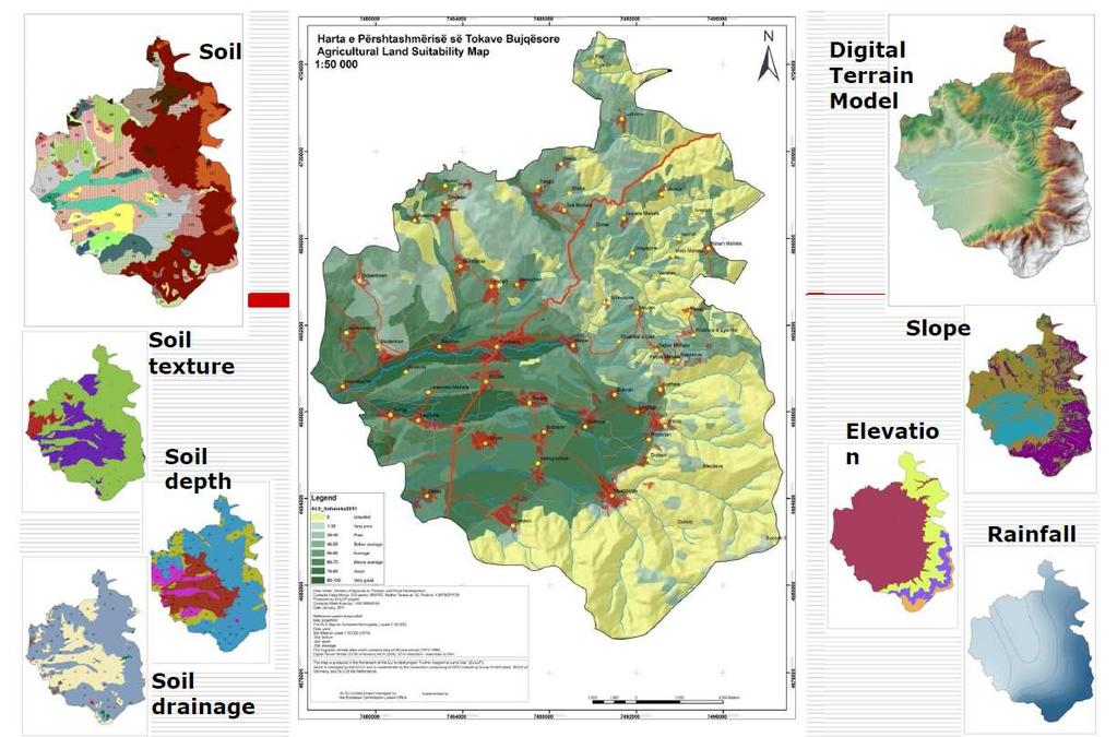
4 METHODOLOGY OF LAND SUITABILITY CLASSIFICATION (MAFRD) AINo. 02/2006 Agriculture Land Suitability Classification Classes SAL The points SAL Suitability Agriculture Land Very good Good Above average Average 5 of Group of Agriculture Land Kept particularly for agriculture production Below average Decisions to protect the agriculture must be taken based on the value Poor Weak land: mainly forestry zone and 7 meadows; it is not reasonable to be 1-35 Very poor kept for agriculture 8 0 Unsuited Mechanized agriculture ploughing is not possible 3 sets of elements: 1. Land (soil type, texture, depth and drainage) 2. Terrain (slope) 3. Climate (altitude and atmospheric precipitation
5
6 Soil Map of Kosovo Kosovo is still using the old Yugoslavian Soil Classification (YSC) system Soil map of Kosovo was completed in 1974 at a scale of 1:50,000,
7 THE GEOGRAPHIC INFORMATION IN KOSOVO Main public civil institutions in Kosovo dealing with Geographic Information: Kosovo Cadastral Agency Kosovo Agency for Statistics Ministry of Environment and Spatial Planning Ministry of Transport and Communication Ministry of Agriculture, Forestry and Rural Development Ministry of Economic Development Independent Commission for Mines and Minerals Municipalities

8 Spatial references and geographical information in Kosovo Country Statistical Regions 7 Municipality, 38 Settlements, 1, In Kosovo we have a lot SDI for Institutional Level but Government is in process to define NSDI according INSPIRE directive. Enumeration Area about 5,000 Buildings about

9 Spatial raster data in Kosovo Institutions Ortophotos map 2013 * Topographic map 1; , * Ortophotos map 2004 * Satellite Imagine 2008 * Ortophotos map 2009 * Satellite Imagine 2010 * Ortophotos map cm Satellite Imagine 2008 / 2010 Resolution 50 cm per pixel 20 cm
10 DISADVANTAGES Spatial data are in: Different format (Shape, Tab, DWG, PDF, paper format etc.) Different coordinate projection (Kosovaref01, Gauss Kruger, UTM WGS 89) Spatial Data are created different methodologies We need to harmonized and to fellow international Standards!
11 Hierarchy of AGRICULTURE Census DATA organized in GIS spatial levels (Country, Regions, Municipality, Settlements) 4 3 ID Settlements ID Municipality 01 1 ID 01 Regions Country X Y Geographical Coordinates


12 SOFTWARE IN USE IN KOSOVO MapInfo ArcGIS generally for making cartographic illustrations Concurrent-use license Tool for analysts analyzing spatial information compiling geographic data managing geographic information in a database i.g. National Official Register of Territorial Division of the Country creating maps Open sources i.g. QuantumGIS Methodological studies, special projects etc.

13 INSPIRE Data Themes ANNEX III ANNEX I 1. Coordinate reference systems 2. Geographical grid systems 3. Geographical names 4. Administrative units 5. Addresses 6. Cadastral parcels 7. Transport networks 8. Hydrography 9. Protected sites 1. Statistical units 2. Buildings 3. Soil 4. Land use 5. Human health and safety 6. Utility and governmental services 7. Environmental monitoring facilities 8. Production and industrial facilities 9. Agricultural and aquaculture facilities 10. Population distribution demography ANNEX II 1. Elevation 2. Land cover 3. Orthoimagery 4. Geology 11. Area management/restriction/ regulation zones and reporting units 12. Natural risk zones 13. Atmospheric conditions 14. Meteorological geographical features 15. Oceanographic geographical features 16. Sea regions 17. Bio-geographical regions 18. Habitats and biotopes 19. Species distribution 20. Energy resources 21. Mineral resources

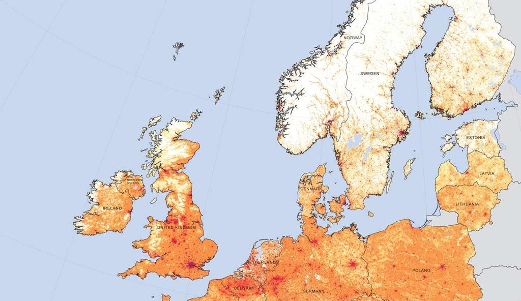
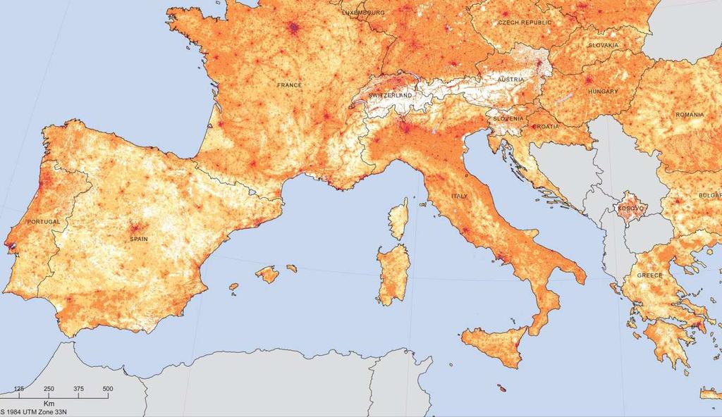
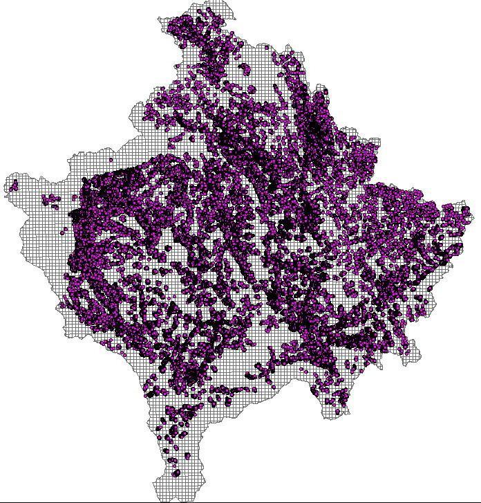
14 Population Density by grid per 1 km² In Kosovo and Europe Statistical/population data for Kosovo are harmonized with Eurostat standards. Micro data Centroids from Buildings


15 Visualization data by maps Agriculture Census publication 100 Maps 30 Statistical indicators Agriculture Census The irrigated area - pipeline

16 NATIONAL GEOPORTAL IS AVAILABLE Raster data Administrative units and parcels Roads, Street name & address system Statistical Indicators


17 NATIONAL GEOPORTAL IS AVAILABLE Raster data Administrative units and parcels Roads, Street name & address system Statistical Indicators
18 Main challenges for land use * Loss of agricultural land due to unplanned urban constructions * Agricultural land parcels fragmentation * Industrial pollution: agricultural land exposes to a constant threat of soil and water pollution; and * Non-sustainable use of agricultural land.

19 Thank you for your attention!
Egnatia Odos Observatory. Egnatia Odos Observatory Monitoring of Egnatia Motorway s s Spatial Impacts
 Egnatia Odos Observatory Egnatia Odos Observatory Monitoring of Egnatia Motorway s s Spatial Impacts 1 Egnatia Odos Observatory 1. The unique Greek observatory of transport and spatial impacts 2. Scope
Prof. Dr Željko Vaško Doc. Dr Tihomir Predić MSc Boris Marković
 First Interim Meeting of the Regional Expert Advisory Working Group on Areas with Natural Constrains Prof. Dr Željko Vaško Doc. Dr Tihomir Predić MSc Boris Marković 29 th June 01 th July, 2016 Andrevlje,
"ST. KLIMENT OHRIDSKI FACULTY OF GEOLOGY AND GEOGRAPHY
 SOFIA UNIVERSITY "ST. KLIMENT OHRIDSKI FACULTY OF GEOLOGY AND GEOGRAPHY APPLICATION OF THE MODEL "DRIVING FORCES PRESSURE STATE - RESPONSE FOR ASSESSMENT OF FLOOD RISK RADOSTINA BORISOVA DOCHEVA Bachelor
Hypsometric demography of Kosovo: the distribution of Kosovo population by altitude
 DOI 10.1186/s40410-016-0047-8 RESEARCH ARTICLE Open Access Hypsometric demography of Kosovo: the distribution of Kosovo population by altitude Rizah Murseli * and Hazer Dana The original version of this
ANNEX V. List of Abbreviations
 ANNEX V List of Abbreviations SEE R&D EU TEN-T GROSEE FP NUTS LAU ESPON Cohesion SMART SWOT MEGA FUA GDP PUSH PIA TRACC RO BG GR EUROSTAT BBU OTP FYROM EC FMA FOCI ECR2 South East Europe Research and Development
Socio-demographic and Economic Profiles of the Regions in the Republic of Macedonia
 Spatial demography of the Balkans: trends and challenges IV th International Conference of Balkans Demography Session 5: Planning and development challenges -----------------------------------------------------------------------------------------------
monitoring of egnatia motorways spatial impacts
 monitoring of egnatia motorways spatial impacts MINISTRY OF ENVIRONMENT, PHYSICAL PLANNING AND PUBLIC WORKS 1 A TOOL AT THE SERVICE OF SPATIAL DEVELOPMENT The Egnatia motorway Observatory monitors, and
Summary table of disaster occurrences, by hazards types, scale, and geographic region
 ANNEX BASIC RANGE OF DISASTER-RELATED STATISTICS TABLES Statistical tables are organised into worksheets according to basic components in the DSRF. The variables represent queries from a disaster-related
Procedures of obtaining the exploitation permit for the utilization of geothermal energy
 Procedures of obtaining the exploitation permit for the utilization of geothermal energy Geothermal Energy in South-East Europe Stuttgart, 30 November 2009. Republic of Serbia - Ministry of Mining and
ORTHOLOGICAL MANAGEMENT OF HYDROLOGICAL RUNOFF BASINS OF THE PREFECTURE OF DRAMA (CURRENT SITUATION PROTECTIVE ACTIONS PERSPECTIVES)
") ORTHOLOGICAL MANAGEMENT OF HYDROLOGICAL RUNOFF BASINS OF THE PREFECTURE OF DRAMA (CURRENT SITUATION PROTECTIVE ACTIONS PERSPECTIVES) This paper presents the torrential environment of the torrents of the
ORTHOLOGICAL MANAGEMENT OF HYDROLOGICAL RUNOFF BASINS OF THE PREFECTURE OF DRAMA (CURRENT SITUATION PROTECTIVE ACTIONS PERSPECTIVES) This paper presents the torrential environment of the torrents of the
SUTTER COUNTY. General Plan Update Technical Background Report
 SUTTER COUNTY General Plan Update Technical Background Report February 2008 SUTTER COUNTY GENERAL PLAN UPDATE TECHNICAL BACKGROUND REPORT PREPARED FOR: SUTTER COUNTY PREPARED BY: PBS&J IN PARTNERSHIP
Deir Hajla Locality Profile
 Deir Hajla Locality Profile Prepared by The Applied Research Institute Jerusalem Funded by Spanish Cooperation 2012 Acknowledgments ARIJ hereby expresses its deep gratitude to the Spanish agency for International
ECORREGIONAL ASSESSMENT: EASTERN CORDILLERA REAL ORIENTAL PARAMOS AND MONTANE FORESTS
 ECORREGIONAL ASSESSMENT: EASTERN CORDILLERA REAL ORIENTAL PARAMOS AND MONTANE FORESTS The Nature Conservancy, EcoCiencia y Fundación AGUA. 2005. Evaluación Ecorregional de los Páramos y Bosques Montanos
M AKING MITROVICA BETTER
 UN HABITAT Municipal Spatial Planning Support Programme in Kosovo Making Better Cities Together Workshop Report July 2007 M AKING MITROVICA BETTER V ISIONING WORKSHOP - THE QUALITY OF THE LIVING ENVIRONMENT
Presentation of activities / projects for the development of cadastre in Kosovo
 Presentation of activities / projects for the development of cadastre in Kosovo Murat MEHA, Avni AHMETI, Muzafer ÇAKA, Korab AHMETAJ, Besmir VESELAJ, Esat XANI Prishtina, 2018 Supporting Development in
Evaluation of realized investments in Belgrade s and Danube region
 MPRA Munich Personal RePEc Archive Evaluation of realized investments in Belgrade s and Danube region Jonel Subić and Lana Nastić and Marijana Jovanović Institute of Agricultural Economics, Volgina 15,
Natural and man-made flooding hazards at the torrents in the town of Thessaloniki
 Risk Analysis VII PI-373 Natural and man-made flooding hazards at the torrents in the town of Thessaloniki S. Stefanidis, F. Tziaftani & C. Chatzicristaki Institute of Mountainous Water Management and
Active Geodetic Network of Serbia
 Active Geodetic Network of Serbia Oleg ODALOVIC and Ivan ALEKSIC, Serbia Key words: GPS, AGROS, RINEX, RTCM SUMMARY In June 2003 the Republic Geodetic Authority (RGZ) has started the realization of the
Conservation of Biodiversity and sustainable land use management in Municipality of Dragash
 Conservation of Biodiversity and sustainable land use management in Municipality of Dragash IDENTIFICATION OF POTENTIAL FOR APPLICATION OF SOLAR ENERGY TECHNOLOGY IN THE MUNICIPALITY OF DRAGASH Prepared
Integrated Management of Shared Lakes Basins. Ohrid and Prespa Lake -Transboundary Cooperation-
 Integrated Management of Shared Lakes Basins Ohrid and Prespa Lake -Transboundary Cooperation- Mrs. Darinka Jantinska, Bilateral Cooperation Head of Division, Ministry of Environment and Physical Planning,
THE ALBERTA GAZETTE, SEPTEMBER
 VILLAGE OF CEREAL Order No. 16915 IN THE MATTER OF THE "Municipal Government Act": File No. 241(A)3 AND IN THE MATTER OF an application by the Council of the Village of Cereal, in the Province of Alberta,
Water resource situation of the Republic of Djibouti
 Water resource situation of the Republic of Djibouti Omar ASSOWE DABAR Integrating Groundwater Management within River Basins 15-17 January 2019 Nairobi, Kenya Regional Training Workshop on Introduction
Deir al Qilt Locality Profile
 Deir al Qilt Locality Profile Prepared by The Applied Research Institute Jerusalem Funded by Spanish Cooperation 2012 Acknowledgments ARIJ hereby expresses its deep gratitude to the Spanish agency for
AGRITECH th December 2017, Podgorica
 AGRITECH 2017 06-07 th December 2017, Podgorica AGRI Potentials of Capital City Podgorica Vladimir Pavićević, MSc Deputy Secretary Secretariat for labor, youth and social care Main characteristics of Montenegro
Assessment of Environmental Impacts of the proposed Sectoral Operational Programme for Tourism and Spa Industry
 Unofficial translation of the original document produced in Czech language Assessment of Environmental Impacts of the proposed Sectoral Operational Programme for Tourism and Spa Industry Assessment team:
SIAVONGA DISTRICT
 SIAVONGA DISTRICT --------------------------------------------------------------------------------------------------------- 1.0 Physical Environment Siavonga District is characterized by an escarpment
communication tower means a tower or structure built to support equipment used to transmit communication signals;
 Ontario Ministry of Natural Resources Subject Communication Tower Sites on Crown Land Compiled by - Branch Lands & Waters Section Land Management Policy PL 4.10.02 Replaces Directive Title Communication
NEEDS FOR NEW CADASTRAL SURVEYING BUILDING REGION IN THE TOWN OF BAČKA PALANKA
 Review Paper doi:10.5937/jaes11-3862 Paper number: 11(2013)3, 257, 129-136 NEEDS FOR NEW CADASTRAL SURVEYING BUILDING REGION IN THE TOWN OF BAČKA PALANKA Dr Miroslav Kuburić* Geoput d.o.o, Belgrade, Serbia
Regional Tourism Satellite Accounts (RTSA) in Austria
 in Austria") Peter Laimer Directorate Spatial Statistics CIS countries and Georgia Workshop III (Session 1) 10-12 June 2013 Baku/Azerbaijan Regional Tourism Satellite Accounts (RTSA) in Austria Methods, data sources,
Peter Laimer Directorate Spatial Statistics CIS countries and Georgia Workshop III (Session 1) 10-12 June 2013 Baku/Azerbaijan Regional Tourism Satellite Accounts (RTSA) in Austria Methods, data sources,
COLOMBIAN SPACE COMMISSION: AN STRATEGY FOR THE SUSTAINABLE DEVELOPMENT OF COLOMBIA
 UN Committee on the Peaceful Uses of Outer Space: 2011 - Fifty-fourth fourth session COLOMBIAN SPACE COMMISSION: AN STRATEGY FOR THE SUSTAINABLE DEVELOPMENT OF COLOMBIA Iván n Darío o Gómez G Guzmán General
2.4. METHODOLOGY: SOILS
 2.4. METHODOLOGY: SOILS FROGS (French Refinement Of Groundwater Scenarios) UIPP Training Paris, 16 November 2011 UIPP Environmental Methodology Working Group DES PRODUITS UTILES - DES ENTREPRISES RESPONSABLES
Silvia Giulietti ETIS Conference Brussels An EEA reporting mechanism on tourism and environment and ETIS
 Silvia Giulietti ETIS Conference Brussels 28.01.2016 An EEA reporting mechanism on tourism and environment and ETIS Main content Why tourism and environment? Why a reporting mechanism on tourism and environment
Egnatia Odos: An axis for development and co-operation
 Egnatia Odos: An axis for development and co-operation Egnatia Odos is one of the two Trans-European transport axes (the other being PATHE) which cross through our country and, together with the Eleftherios
Geological Report on Limestone Exploration Of Bhatvadiya Block Of EXECUTIVE SUMMARY
 Geological Report on Limestone Exploration Of Bhatvadiya Block Of Kalyanpur Taluka, Devbhumi Dwarka District, Gujarat. EXECUTIVE SUMMARY Prepared for: Gujarat Mineral Research & Development Society Government
Chapter 21: EAST AFRICA
 Chapter 21: EAST AFRICA Physical Geography of East Africa Landforms East Africa is a diverse landscape of different plains, volcanic mountains, and plateaus cut by a large valley and marked by many rivers
Policy PL Date Issued February 10, 2014
 Subject RENEWABLE ENERGY ON CROWN LAND Compiled by Renewable Energy Program, Biodiversity Branch Replaces Policy Directives Waterpower Site Release Crown Land Onshore Windpower Development - Crown Land
Adapting water resource management in coastal areas A case study in Hai Phong, Vietnam
 Adapting water resource management in coastal areas A case study in Hai Phong, Vietnam Thuc Phan, James Smart, Samantha Capon, Wade Hadwen Australian Rivers Institute, Griffith University Presentation
CHAPTER IV OVERVIEW. Indonesia. The capital is Dompu. Dompu Regency has an area of 2, km².
 CHAPTER IV OVERVIEW A. General Description of the Research Sites Dompu Regency, is a district in West Nusa Tenggara Province, Indonesia. The capital is Dompu. Dompu Regency has an area of 2,321.55 km².
Intermediate report. Letter of agreement FAO - GCB/RAB/013/ITA
 Treated waste water for sustainable production of valuable biomass, soil and water quality improvement and combating desertification in Algeria and Tunisia Letter of agreement FAO - GCB/RAB/013/ITA Intermediate
Provincial Review 2016: Limpopo
 Provincial Review 2016: Limpopo Limpopo s growth since 2003 has been dominated by the mining sector, especially platinum, and by national construction projects. As a result, the provincial economy grew
Presentation from 2015 World Water Week in Stockholm. The authors, all rights reserved. SIWI siwi.org
 Presentation from 2015 World Water Week in Stockholm www.worldwaterweek.org The authors, all rights reserved SIWI siwi.org WORLD WATER WEEK Stockholm, 23 th August 2015 Co-operative water governance: catalyst
Lessons Learned from the Floods this May
 Building Resiliance to Disasters in Western Balkans and Turkey Design a Regional Multi-Hazard EWS Composed of harmonized National EWS econd Meeting of the Design Team 9 11 September 2014, Durrës, Albania
PPCR/SC.4/5 October 9, Meeting of the PPCR Sub-Committee Washington, D.C. October 28, REVIEW OF ON-GOING WORK OF THE MDBs IN DJIBOUTI
 PPCR/SC.4/5 October 9, 2009 Meeting of the PPCR Sub-Committee Washington, D.C. October 28, 2009 REVIEW OF ON-GOING WORK OF THE MDBs IN DJIBOUTI Proposed Sub-Committee Decision The Sub-Committee reviewed
Implementation of PBN in Armenian airspace
 Implementation of PBN in Armenian airspace PBN implementation plan, based on the specifications of the airspace of the Republic of Armenia, has been developed in accordance with Resolution A36-23, approved
Dr. Dimitris P. Drakoulis THE REGIONAL ORGANIZATION OF THE EASTERN ROMAN EMPIRE IN THE EARLY BYZANTINE PERIOD (4TH-6TH CENTURY A.D.
 Dr. Dimitris P. Drakoulis THE REGIONAL ORGANIZATION OF THE EASTERN ROMAN EMPIRE IN THE EARLY BYZANTINE PERIOD (4TH-6TH CENTURY A.D.) ENGLISH SUMMARY The purpose of this doctoral dissertation is to contribute
UNSD Environment Statistics Self Assessment Tool (ESSAT) and COMESA Environmental Statistics Assessment 2014
 and COMESA Environmental Statistics Assessment 2014") UNITED NATIONS STATISTICS DIVISION (UNSD) Workshop on Environment Statistics in support of the implementation of the Framework for the Development of Environment Statistics (FDES 2013) Balaclava, Mauritius
UNITED NATIONS STATISTICS DIVISION (UNSD) Workshop on Environment Statistics in support of the implementation of the Framework for the Development of Environment Statistics (FDES 2013) Balaclava, Mauritius
Melinda McCoy, CDM Project Manager Jonathan Posner, CDM Steven Wolosoff, CDM Don Schroeder, CDM
 A Task 8-1 GIS List of Lands for BMPs for North Santa Monica Bay Regional Watershed Implementation Plan and Malibu Creek Watershed Bacteria TMDL Implementation Plan To: From: Carolina Hernandez, of Watershed
Robert Salmeyer Helmut Fellner. Jaroslav Dupal. Mihaly Lados
 DANUBE SPACE STUDY Regional and Territorial Aspects of Development in the Danube Countries with Respect to Impacts on the European Union Final Report July 2000 Commissioned by: European Commission DG:
Visual and Sensory Aspect
 Updated All Wales LANDMAP Statistics 2017 Visual and Sensory Aspect Final Report for Natural Resources Wales February 2018 Tel: 029 2043 7841 Email: sw@whiteconsultants.co.uk Web: www.whiteconsultants.co.uk
Regional Tourism Satellite Accounts in Austria sufficient information for regional tourism policy?
 Peter Laimer Directorate Spatial Statistics 11 th Global Forum on Tourism Statistics (Session 4) 14 16 November 2012 Regional Tourism Satellite Accounts in Austria sufficient information for regional tourism
Nansanga Profile. Population and Land Use.
 Nansanga Profile Population and Land Use. Settlements in Nansanga are linearly aggregated in plateau area along the Serenje Mapepala road, with densely populated Mukomansala, Mapepala, Shindaila, and Nabowa
CRI Loreto. IIAP crew seining for Colossoma macropomum broodstock at the CRI Loreto research site in Peru.
 PERU CRI Loreto 43 PD/A CRSP SITE DESCRIPTIONS CRI Loreto Marcos J. De Jesús Marcos J. De Jesús IIAP crew seining for Colossoma macropomum broodstock at the CRI Loreto research site in Peru. Hatchery facilities
7. Education Degree: Institution: Darmstadt University of Technology, Darmstadt, Germany Degree Date: Degree : Dr.-Ing.
 CURRICULUM VITAE 1. Family Name: Ameti 2. First Name: Perparim 3. Nationality: Kosovar 4. Date of Birth 16.02.1973 5. Gender: M 6. Contact details: Faculty of Civil Engineering and Architecture Email:
!!!!!!!!!!Mali s Geographic Makeup
 DANU Strategic Forecasting Group May 27th 2016!!!!!!!!!!Mali s Geographic Makeup By Liliana Pirlea Location: Mali is a landlocked country located in West Africa. Mali is the 8th largest country in Africa
Creative Industries in Greece
 Creative Industries in Greece Alina Hyz Kostas Karamanis Creative Industries in Greece An Empirical Analysis from the Region of Epirus Alina Hyz Piraeus University of Applied Sciences, Greece Kostas Karamanis
Investigation on Development of Agricultural Monitoring System Using Satellite Data
 Investigation on Development of Agricultural Monitoring System Using Satellite Data Genya SAITO (1), Daisuke KUNII (1), Naoki ISHITSUKA (2) (1) Tohoku University, 1-1,Tsutsumidori Amamiya-machi Aoba-ku,
Land Consolidation in Serbia
 Land Consolidation in Serbia Stevan Marošan University of Belgrade, Faculty of Civil Enginering Zoran Knežević Ministry of Agriculture, Forestry and Water Management Marija Marošan Attorney at law Regional
ARTWEI ARTWEI ARTWEI
 Protection / Management Plans for Natura 2000 areas and Maritime Spatial Plan for internal sea waters - including the Szczecin Lagoon Szczecin, 7th May 2011 Andrzej Zych Inspectorate of Coast Protection
Air Traffic Control & Management
 Air Traffic Control & Management To fully understand the varying performance characteristics of aircraft, it is necessary to understand certain elements of the environment in which they operate. The performance
PERMANENT MISSION OF BELIZE TO THE UNITED NATIONS
 PERMANENT MISSION OF BELIZE TO THE UNITED NATIONS 675 Third Ave. Suite 1911 New York, New York 10017 Tel: (212) 986-1240/(212) 593-0999 Fax: (212) 593-0932 E-mail: blzun@belizemission.com STATEMENT DELIVERED
Nature conservation, protected areas & ecological connectivity
 Nature conservation, protected areas & ecological connectivity Taja Ferjančič Lakota, Permanent Secretariat of the Alpine Convention in cooperation with Alparc The Alpine Convention First international
Robson Valley Avalanche Tract Mapping Project
 Robson Valley Avalanche Tract Mapping Project Prepared for: Chris Ritchie Ministry of Water Land and Air Protection 325 1011 4th Avenue Prince George, BC. V2L3H9 and Dale Seip Ministry of Forests 1011
Applying a methodology of production potential based on the type of soil and climate: Mozambique
 The 22 nd International Symposium on Alcohol Fuels 22 nd ISAF Applying a methodology of production potential based on the type of soil and climate: Mozambique Felipe Haenel Gomes a *, Rafael Aldighieri
SUSTAINABLE AND ENVIRONMENTALLY FRIENDLY TOURISM IN THE COASTAL ZONES OF THE BALTIC SEA AREA
 CONVENTION ON THE PROTECTION OF THE MARINE ENVIRONMENT OF THE BALTIC SEA AREA HELSINKI COMMISSION - Baltic Marine HELCOM 21/2000 Environment Protection Commission Minutes of the Meeting 21st Meeting Helsinki,
OLIVE GROWING IN MONTENEGRO, SITUATION AND PROSPECTS
 OLIVE GROWING IN MONTENEGRO, SITUATION AND PROSPECTS Biljana Lazovic University of Montenegro Biotechnical Faculty - Centre for Subtropical Cultures, Bar Montenegro: Area 13.812 km2, Total population 650.000
Technical Explanation Introduction
 Technical Explanation Introduction Local population of Volkovo and Orman has objected through their authorised representatives about the location of the North Bypass of Skopje route. The objections are
KOSOVO. Explore the Balkans - Business Opportunities
 Explore the Balkans - Business Opportunities KOSOVO Pia Stjernvall, Ambassador, Embassy of Finland in Pristina Jehona Ademaj, Coordinator, Embassy of Finland in Pristina KOSOVO Independent since 2008 Recognized
A GIS Assessment of Erosion Vulnerability for Unofficial Trails in the Columbia River Gorge
 A GIS Assessment of Erosion Vulnerability for Unofficial Trails in the Columbia River Gorge Sachi Arakawa Geog 593 Digital Terrain Analysis Fall 2017 Abstract The city of North Bonneville, located along
Croatia completes inventory of wetlands
 Croatia completes inventory of wetlands 16 October 2006 Croatia CRO-WET - Croatian Wetland Inventory SGF project completed The Croatian State Institute for Nature Protection (SINP) carried out a comprehensive
Applying Geospatial Tools to Produce Data for SDG Indicators in Mexico
 Applying Geospatial Tools to Produce Data for SDG Indicators in Mexico Inter-Agency and Expert Group On SDGs Indicators Enrique Ordaz Francisco J. Jimenez Stockholm November 2018 Background INEGI has produced
Management of national park directorates in Hungary, land purchase
 Management of national park directorates in Hungary, land purchase SK-HU Working Group on Nature Conservation and Landscape Protection Dunajská Streda, 27 February 2018 András Schmidt Deputy Head of Department
D2. Islands and tourism
 5 th European Conference on Sustainable Urban Mobility Plans 14-15 MAY 2018 NICOSIA, CYPRUS D2. Islands and tourism S I M P Year-round Sustainable Island Mobility Planning Alexia Spyridonidou Kosmas Anagnostopoulos
Public Works Research Institute
 Public Works Research Institute INTERNATIONAL WORKSHOP ON WATER HAZARD AND RISK MANAGEMENT SOME EXPERIENCES OF FLOOD MANAGEMENT IN ARGENTINA VÍCTOR POCHAT National Director for Water Policies,Coordination
Brief Description of Northern the West Bank, Palestine Prepared by: Dr. Ahmed Ghodieh Department of Geography An-Najah National University Nablus,
 Brief Description of Northern the West Bank, Palestine Prepared by: Dr. Ahmed Ghodieh Department of Geography An-Najah National University Nablus, Palestine Brief Description of Northern the West Bank
What Is An Ecoregion?
 Ecoregions of Texas What Is An Ecoregion? Ecoregion a major ecosystem with distinctive geography, characteristic plants and animals, and ecosystems that receives uniform solar radiation and moisture Sometimes
Survey of National Coastal and Marine SDI geoportals: worldwide developments
 GSDI Marine/Coastal SDI Capacity Building Workshop INSPIRE CONFERENCE 2016 Survey of National Coastal and Marine SDI geoportals: worldwide developments Jade Georis Creuseveau Roger Longhorn Joep Crompvoets
Submission of REPUBLICA ORIENTAL DEL URUGUAY. to the COMMISSION ON THE LIMITS OF THE CONTINENTAL SHELF
 Submission of REPUBLICA ORIENTAL DEL URUGUAY to the COMMISSION ON THE LIMITS OF THE CONTINENTAL SHELF pursuant to provisions of article 76, paragraph 8, of the United Nations Convention on the Law of the
Lake Ohrid. our shared responsibilities and benefits. Protecting
 Towards strengthened governance of the shared transboundary natural and cultural heritage of the Lake Ohrid region Protecting Lake Ohrid region our shared responsibilities and benefits This publication
MUNICIPALITY OF PRESEVO
 Vision of municipality The vision of the municipality of Presevo in the next decade (2005th-2015th), is to become a municipality which is economically viable, environmentally clean, economic and tourism
Environmental Development of River Road Ranch
 Environmental Development of River Road Ranch New Braunfels, Texas Alix Scarborough GEO 3426 April 2012 Introduction The 2,400-acre Word-Borcher ranch has been owned by the Word family since 1941. Located
MONITORING OF LAKE NASSER USING REMOTE SENSING AND GIS TECHNIQUES
 MONITORING OF LAKE NASSER USING REMOTE SENSING AND GIS TECHNIQUES M. M. Mostafa a and H. K. Soussa b a Information Technology Institute, GIS department - mostafam@mcit.gov.eg b Ain Shams University, Faculty
June11, 2012 París, France
 June11, 2012 París, France Content 1 Objectives 2 INEGI and SNIEG 3 Georeferenced indicators Cases Other applications Indicators 2 1. Objective To present the use of applications of territorial indicators
Monitoring the Environmental Status of the Heart of Borneo
 Monitoring the Environmental Status of the Heart of Borneo By: Stephan Wulffraat The Heart of Borneo conservation initiative has been going on now for several years and has gained increasing support from
ANC Interim meeting Country report- R. of Macedonia. Dusko Mukaetov, Nina Aleksovska, Ordan Cukaliev
 ANC Interim meeting Country report- R. of Macedonia Dusko Mukaetov, Nina Aleksovska, Ordan Cukaliev General characteristics of the Republic of Macedonia is located in the central part of the Balkan Peninsula.
Chapter 16 ~ Eastern Mediterranean
 Chapter 16 ~ Eastern Mediterranean Physical Geography of the Eastern Mediterranean Landforms This area is known as the Levant and includes Syria, Jordan, Lebanon, Israel, and the Palestinian territories.
SOUTH INTERCHANGE AREA
 Santaquin City General Plan 1 Location and Characteristics The South Interchange Area of Santaquin is located west of Interstate 15 and south of 500 South (Figure 1). It includes properties already annexed
What I want to know about the Balkans.
 Name Balkan Basics KWL What I know about the Balkans. What I want to know about the Balkans. What I learned about the Balkans. Name Balkan Basics Country Profile T-Chart Use the Balkan Basics Country Profile
Sava Commission Activities. KICK-OFF MEETING DANTE, February 17, 2017, Budapest
 Sava Commission Activities KICK-OFF MEETING DANTE, February 17, 2017, Budapest 1 Establishment of the ISRBC 2 Decay of SFRY a challenge to WRM in the Sava river basin Sava river used to be the biggest
Mobility and transport
 Mobility and transport Introduction to the Strategy game Transalpin Permanent Secretariat of the Alpine Convention Content The Alps an abstract idea? Our common activities The Alpine Convention Implementation
THE IMPLEMENTATION OF EWFD/WFD IN THE REGION OF VOJVODINA WITHIN JOINT SLOVAK-SERBIA SERBIA PROJECTS
 Towards Integrated River Basin Management The 55 th Anniversary of the Founding of the Water Research Institute THE IMPLEMENTATION OF EWFD/WFD IN THE REGION OF VOJVODINA WITHIN JOINT SLOVAK-SERBIA SERBIA
Key Indicators for South Sudan
 Key Indicators for South Sudan National Bureau of Statistics Fast Facts Total Population of South Sudan is 8.26 million Total Area of South Sudan is 644,329 sq. km More than half (51%) of the population
STATE -OF-ART OF GEODESY IN THE REPUBLIC OF MACEDONIA
 STATE -OF-ART OF GEODESY IN THE REPUBLIC OF MACEDONIA Prof. Zlatko Srbinoski PhD Faculty of Civil Engineering Chair for high geodesy VIENNA, JULY 2008 REPUBLIC OF MACEDONIA Center of Balkan Peninsula a2
TSA governance at national level
 Mr. Peter Laimer Directorate Spatial Statistics UNWTO/DG GROW TSA-Workshop Agenda Item 6 TSA governance at national level Austrian experiences Brussels, 29/30 November 2017 www.statistik.at We provide
TRADE: TOURISM. The Trade Related subjects is Building/Engineering Drawing.
 TRADE: 400 - TOURISM EXAMINATION STRUCTURE This Trade is made up of the following modules i. Travel Operation CTP12 ii. Geography of Nigeria CTP13 iii. Basic Tourism Entrepreneurship CTP10 iv. Basic Tourism
Water quality management in the Lake Baikal region of Russia
 Lomonosov Moscow State University Faculty of Geography Department of Environmental Management Water quality management in the Lake Baikal region of Russia Dr., Prof. Sergey Kirillov Dr., Prof. Mikhail
Where are the poor: Region and District Poverty Estimates for Tanzania, 2012
 Where are the poor: Region and District Poverty Estimates for Tanzania, 2012 Blandina Kilama bkilama@repoa.or.tz SK Conference Room, Umoja House Building, Ground Floor 30 June 2016 Outline Overview Population,
Spatial Assessment for the revised Mpumalanga Biodiversity Expansion Strategy. Mervyn Lotter Scientific Services 8 June 2016
 Spatial Assessment for the revised Mpumalanga Biodiversity Expansion Strategy Mervyn Lotter Scientific Services 8 June 2016 Mpumalanga Protected Area Expansion Strategy (MPAES) Developed our first MPAES
REPUBLIC HYDROMETEOROLOGICAL SERVICE OF SERBIA. MEDARE 3 rd Expert Group Meeting Istanbul, Turkey September 2012
 REPUBLIC HYDROMETEOROLOGICAL SERVICE OF SERBIA MEDARE 3 rd Expert Group Meeting Istanbul, Turkey 27 28 September 2012 BRIEF HISTORY Meteorological and hydrological activity in the territory of Serbia has
Connecting Northern Tanzania
 Connecting Northern Tanzania A socio-economic comparison of the alternative routes for a highway from Arusha to Musoma by Frankfurt Zoological Society J. Grant C. Hopcraft (May, 2011) Tanzania s Road Network
SANBI PLANNING FORUM
 SANBI PLANNING FORUM SPATIAL PLANNING IN PROTECTED AREAS AND THEIR BUFFERS (South Africa) Ms Jayshree Govender, Dr Mike Knight and Mr Russell Smart 22 June 2017 OUTLINE 1) Introduction 2) Protected areas