MESA 4 WHEELERS HORN NEWSLETTER
|
|
|
- Elfreda Jefferson
- 5 years ago
- Views:
Transcription


1 MESA 4 WHEELERS HORN NEWSLETTER August 2018 Mesa 4 Wheelers, PO Box 107, Mesa AZ MESA 4 WHEELERS STAFF President Lee Coppage Vice President Bill Mihailov Secretary Pat Jenkins Treasurer Ray Jenkins Corres.Secretary Hazel Hart Membership Lori Moore Editor Mike Drawsky Remembrance Gert Leible Trophies Clete Hruska Safety Chairman John Hart Publicity OPEN Next Meeting August 17, 2018 Third Friday of every month, 7:00 PM. Bass Pro 1133 North Dobson, Mesa, AZ (602) PRESIDENT'S CORNER Hello all, Hope to see you out on the trails, Your Prez, REMEMBER WHEN? 30 years ago? August 1988 EARLY BIRD RUN August is one of the hottest months here in Arizona, so putting a 4x4 Run on near town is a challenge. The report for August was that there would be an early morning Breakfast trip to the Four Peaks area. The Trip announcement said: On August 7th the meeting place will be at 6:00 A.M. with a pull-out time of 6:30 A.M. at the Four Peaks turn off. Bring all your breakfast makings, as we will cook breakfast at 7:15. We will be back in town by 9:30 A.M. before the Arizona summer heat takes over the day. Please call Hec Ramsey by August 5th if you plan on coming. I remember the Early Bird Run was a success and all had a great breakfast meal in the desert. Ray Jenkins Lee Coppage (Lonewolf)


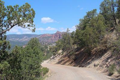
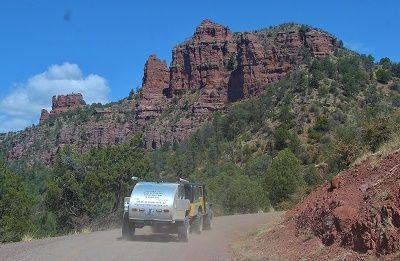
2 Wheeling Across Arizona (With Gary & Brian Keller, Ray Andrews, Richard Friese, Larry Blau & Jess Chinn, Mike Drawsky and Jim & Charmaine McKaskle) From left to right: Brian, Gary, Larry, Ray and Richard. camper trailer. Ray & Mike, posing next to Ray s off-road Last April, I had the privilege of driving new to me, Arizona Backroads with Gary Keller, his son Brian and a number of their close friends. The goal for this 11-day off-road adventure was to extend the current Great Western Trail, from Florence to Benson (Approx. 125 miles) and run Gary & Brian s East-West Trail, from Alpine, Arizona to Fort Mojave, near the border of California and Nevada. History of the Great Western Trail Lyle Gomm, a former Intermountain Region Trail Coordinator, is the "father" of the GWT. His idea to create a long-distance trail open to a variety of users began in Utah during the 1970s, and in 1985 he organized an inter-agency team including the Forest Service, Utah Department of Natural Resources, Bureau of Land Management, and the National Park Service to create the Bonneville Rim Trail to connect the Grand Canyon and Yellowstone National Parks. In 1986, Dale Sheewalter, a volunteer promoter of the Arizona Trail (Grand Canyon National Park to Nogales, Mexico), suggested the Arizona and Bonneville Rim Trails be renamed the "Great Western Trail." In 1988, Simon Cordial, 26, from England, and James Mayberger, 29, from New York, teamed up to become the first to thru-hike the proposed GWT from Canada to Mexico. Their journey began June 1, near Priest Lake State Park, Idaho, and ended October 15, 1988 at the Mexican border a few miles east of Douglas, Arizona. In 1990, the Great Western Trail Association was incorporated under the provisions of the Utah Nonprofit Corporation and Cooperative Association Act. The Great Western Trail joins backcountry trails, dirt or gravel roads, and highspeed highways, to create a system of routes that terminate independently or rejoin a main route. It was conceived as a 4,500-mile long network of preexisting trails that would traverse central Arizona, Utah, and Wyoming, and end at the Idaho-Montana border with Canada. The Great Western Trail in Arizona Gary Keller, a Member of Off Highway Vehicle Advisory Group (OHVAC) has played a major role in the route selection for the portion of Great Western Trail running through the state of Arizona. The Great Western Trail meanders through sandy deserts and forested mountains and presents many challenges. Maps are available at Ranger Stations in the Tonto, Kaibab, and Prescott National Forests, as well as in the guidebook Driving the Great Western Trail in Arizona. The trail sections in the southern part of the state are open year-round. Sections in the north may be closed from December to May due to snow or flooding. A permit is required to drive on state lands, in the
3 Tonto Forest, on Indian Lands, and to drive Bulldog Canyon section of the GWT. There are no services along the GWT. Bulldog Canyon in the Tonto National Forest, the first leg of the trail, was dedicated in April Two years later the 72-mile Cave Creek segment was completed and the Sears-Kay Ruin, an ancient Hohokam village atop a hill overlooking Cave Creek, became the first "Point of Discovery." This passes the Seven Springs Campground, an oasis developed by the Civilian Conservation Corps in the 1930s, as it winds its way to Bloody Basin Road. It then crosses the Agua Fria National Monument or, for the more adventurous, turns north on a rocky trail that crosses shale ledges and rivers to Dugas and to the San Dominique Winery before crossing grasslands, riverbeds, and over Mingus Mountain to enter Martin Canyon, known as Smiley Rock because of a pumpkin sized rock on the trail that appears to have eyes, nose, and a mouth. From here it is a leisurely ride to Jerome, a mining town that rapidly declined after mining ended in Artisans have revived it and it is now a tourist destination. The trail then goes north to Perkinsville in the Verde Valley and onto the Mogollon Rim and the world's largest stand of Ponderosa pines. Sycamore Canyon with its red sandstone sculptures, is another "Point of Discovery." The trail continues to Parks and Williams on I-40, and though the grasslands and forests of the Williams Ranger District of the Kaibab National Forest, before entering the Tusayan Ranger District. This section of the trail, after a bewildering patchwork of unmarked paths on the Navajo Nation, (not officially part of the Great Western Trail), then slips off the Coconino Plateau south of the Little Colorado River Gorge in the austere world of red and white sandstone. After crossing the Navajo Bridge over Marble Canyon, and skirting the Vermilion Cliffs, the GWT starts anew at House Rock Valley Buffalo Ranch with a difficult ascent into the mountains along a trail at the base of the Kaibab Plateau. A marker states that Spanish priests Dominquez and Escalante traded for food with the Paiute Indians in North of South Fork Canyon the GWT ascends the north plateau of the Kaibab National Forest where California Condor soar in the thermals above the Vermillion Cliffs, and Rocky Mountain elk, white-tailed and mule deer, horses, antelope, black bear roam. A few miles southeast of Jacob Lake, the last leg of the trail travels north to Orderville Canyon, descends the North Kaibab Plateau toward the Buckskin Mountains and into Utah with views of the Chocolate, Vermilion, and White Cliffs. History of the Arizona East-West Trail Starting in 1998 Gary, his son Brian and a few of Gary s close friends began working together mapping out an off-pavement route from New Mexico to California, naming it the East-West Trail (617 miles in length). The Arizona East West Trail starts or ends near Alpine, Arizona. It heads south from Luna Lake down the Blue River, dips Into New Mexico for about a mile, and then back to Arizona. Deer, elk and the Mexican Gray Wolf are abundant in the area. The trail crosses the center of the state through Alpine, Pinetop, Lakeside, Forest Lakes, Punkin Center, Fountain Hills, Carefree, Rock Springs, Black Canyon City, Bumble Bee, Cleater, Crown King, Wickenburg, Octave, Stanton, Hillside, Bagdad, Wikieup, Kingman, Oatman, Bullhead City and starts or ends at Avi Casino in the southern tip of Nevada Along the Colorado River.


 Ray, Larry & Gary displaying the Great Western Trail banner.")
4 Day 1 (Tuesday, April 17, 2018) Midway between Florence & Kelvin, along the Florence/Kelvin Highway, Brian & Gary set up our first camp. Tomorrows destination, Peppersauce Campground along Mt. Lemmon Rd. at the base of Mount Lemon. Our first 3 days were spent exploring a possible southern extension of the Great Western Trail, from Florence to Benson. We made it within 50 miles of Benson before a leaf spring broke on Gary's utility/camping trailer. We were able to strap it together well enough for a 5-mile run to the nearest town, San Manuel. To keep on schedule, Gary left the trailer off for repairs, transferred his camping supplies over to his Jeep and we headed northeast in the direction of Alpine (225 miles). Day 2 (Wednesday, April 18, 2018) Ray, Larry & Gary displaying the Great Western Trail banner. Second day on the trail, 20 miles north of Oracle, on Tecolote Ranch Road, we come across a ranch hand standing in a dried out well. A young calf had fallen in and was unable to get out.


5 Using two tow straps, the ranch hand raped them around the calf, and 5 of us were able to lift the calf out. Gary new the name of the ranch owner, handed the Near Oracle we came across this cross-country ranch hand his card and told him to pass it along to cyclist. He was riding the Arizona Trail, running him. paralleled to us. He had started at the Mexico border and was planning to go as far as the Arizona/Utah border. Second camp, Peppersauce Campground along Mt. Lemmon Rd
 Third day on the trail,")


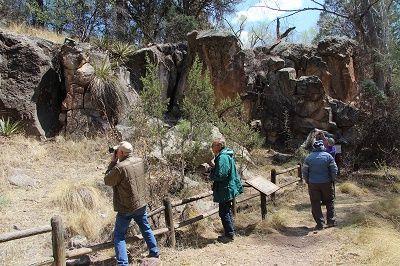
6 Day 3 (Thursday, April 19, 2018) Third day on the trail, a mile east of Mt. Lemon Road, heading towards Redington, destination, Benson. In the middle of nowhere, Gary pulls to the side of the road and takes us to these grave markers. If you did not know they were there you would have missed them.


 4th Day: From Alpine we used forest roads to make our way over to New Mexico,")

7 Off in the distance, the Galiuro Mountains Heading Northeast along Hwy.77, destination Alpine 50 miles north of Benson, the leaf spring on Gary s utility/tent trailer broke. Using ratchet straps, we were able to line up and secure the axle well enough to drive to the nearest town of San Manuel where Gary found an auto repair shop to leave it off for repairs. Instead of finishing our run to Benson, we decided to head for Alpine about 170 miles northeast of San Manual. Day 4 (Friday, April 20, 2018) 4th Day: From Alpine we used forest roads to make our way over to New Mexico, and back into Arizona. The days destination, Green's Peak Lookout, northwest of Greer. As we neared Greer the winds had picked up and the temperatures had dropped to near freezing. We abandon the idea of camping and back tracked too Eager for a warm bed and hot meal. By late evening it was snowing!


8
 Greens Peak,")


9 Day 5 (Saturday, April 21, 2018) Greens Peak, elevation 10,133 ft. 5th Day: Headed to Greens Peak over to Pinetop, Lakeside, drove 300 Rim Road to Gentry Lookout, and set up camp at Valentine Ridge Campground, northeast of Young.


10 The snow that had fallen covered the forest floor from Greens Peak to nearly as far as Pinetop-Lakeside Los Burros Ranger Station, horse corral Historic Los Burros Ranger Station Camping is permitted at Los Burros and attracts a large turnout during the summer months.


 Forest Road")


11 Pinetop-Lakeside, from left to right: Mike, Ray, Brian, Jesse, Larry & Gary Gentry Lookout Tower along Rim Road 300. Day 6 (Sunday, April 22, 2018) Forest Road 202, along the west border of the Fort Apache Reservation. Forest Road 202, with the Sierra Ancha Mountains In the foreground.


 to the")


12 Cherry Creek crossing Lunch stop along Cherry Creek Larry, crossing Cherry Creek Gary, crossing Cherry Creek Jesse crossing Cherry Creek View from A-Cross Road, near Roosevelt Lake 6th Day: Followed FR202 south (bordering the west side of the Fort Apache Reservation) to FR203 (Cherry Creek Road) to the Globe/Young Hwy. near the Salt River. Traveled along the east side of Roosevelt Lake (A-Cross Road), to Hwy Drove the El Oso Rd. up and over 4-Peaks and spent the night at home with Linda.


13 Photos of 4-Peaks taken from A-Cross Road that runs along the east side of Roosevelt Lake, from the Globe/Young Highway to Pumpkin Center. El Oso Road, running up the east side of 4-Peaks Mohave Rattlesnake crossing Cline Cabin Road, Cline Cabin Road, driving down the west side of Portion of the Great Western Trail running from 4-Peaks, with Weavers Needle in the background. Needle Rock through Agua Fria National Monument. (Monday, April 23, 2018) Day of Rest


14 Day 7 (Tuesday, April 24, 2018) Needle Rock, Verde River Gary taking a picture of Mike at Needle Rock Rec. Area Took a day off, then met up at Denny s in Fountain Hills to begin the second half of the East-West Trail. 7 th Day: Fountain Hills thru Rio Verde, Needle Rock, Camp Creek, Seven Springs, New River Road, finishing up at Crown King at a very nice B&B, Bradshaw Mountain Guest Ranch. Camp Creek Seven Springs Road Forest Road 41, from 7-Springs Road to Table Mesa, at Interstate 17.


15 Forest Road 41, from 7-Springs Road to Table Mesa, at Interstate 17. Forest Road 41, crossing New River. Stopping for some delicious pie at Rock Springs, before continuing on up to Crown King.


16 Passing through the old mining town of Cleator Ray setting up camp near downtown Crown King While Ray camps, Mike, Gary, Brian and Jesse decide to sleep in comfort at the Bradshaw Mountain Guest Ranch, in downtown Crown King. Day 8 (Wednesday, April 25, 2018) Crown King Saloon


17 Southwest view from the Senator Highway, about Remanence of the mining town of Lapham, along the 3 miles west of Crown King. Wagoneer Road, in the Bradshaw Mountains.

, Minnehaha")


18 Brian, driving down Ryland Gulch, between Minnehaha Flats and Castle Hot Springs Ryland Gulch 8th Day: Crown King, Senator Hwy., Wagoner Road (FR362), Minnehaha Flats, Ryan Gulch, Walker Gulch, Constellation Rd., stopping in Wickenburg to change out Mike s broken leaf spring and to spend the night. Near Walker Gulch, northwest of Castle Hot Springs


19 Day 9 (Thursday, April 26, 2018) We met up with Jim & Charmaine McKaskle, just north of Wickenburg. Jim has a friend in the mining business and has offered to give us a tour. The old Octave Mine, near Stanton has been reopened. The tailings and the mine tunnels are being reworked and a new processing plant is under construction. Freshly poured concrete foundation for the new processing plant. New heavy-duty dump trucks, excavators and rock crushers are busy reworking the tailings. A mile west of Octave Mine is the old mining town of Stanton.


20 A bit of History The town of Stanton, like the towns of Octave and Weaver, owe their existence to a group of pioneers who discovered gold in the area in Led by the frontiersman Pauline Weaver, the explorers were camped along Antelope Creek when one of the men - a tracker named Alvaro - decided to go chasing after a runaway burro. After climbing to the top of what would become known as Rich Hill, Alvaro tripped over a pile of gold nuggets that were "as big as potatoes." Soon after, Pauline Weaver and a friend named Jack Swilling found another pile of gold on top of nearby Antelope Hill. Weaver said that gold was so plentiful in the area that he could pop nuggets out of the ground with a knife, and that one acre yielded nearly $500,000 in gold


21 9th Day: From Wickenburg, we headed for Stanton, stopping off at the Octave Mine for a private tour. From Stanton we followed Date Creek Rd., through Piedmont, Hawkins to Hillside. From Hillside we made our way to Bagdad, following back roads that brought us in on the north end of town. Just as we were entering Bagdad, Mike s other rear leaf spring broke! It was safe enough to drive home on, but to risky for another day and half of back roads driving, so Mike said goodbyes to everyone, thanked Gary & Brian for inviting him, and headed for home!


22 Day 11 (Saturday, April 28, 2018) Gary, Brian and Ray at the west end of the Arizona East-West Trail, border of Arizona & California Ray Andrews, who has published 3 books on the Great Western Trail, traveled down from Seattle, Washington, to document this trip. His goal is to have it available in paperback, showing all the major GPS coordinates, by year end. Happy Trails, Mike


23 CLUB TRIP REPORTS Jack Handle Trip Leader: Lee & Bev Coppage Date: 07/28/18 Members in attendance: Clete & Randi Hruska Well we ran Jack Handle yesterday! Had one couple brave the heat!
 Trip Leader: Mike Drawsky Contact: 480-216-2730 When: Saturday, August 25th Meet: Denny s, Fountain Hills, 7:00 breakfast, 8:00 Pullout Trail Rating: 3")

24 Jack Handle (Continued) FUTURE TRIPS & EVENTS Sycamore Creek Trip Leader: John Guthrie Contact: When: Saturday, August 18th Meet: Pullout: Trail Rating: 3 Finish: Approx. Sunflower Mine (Pre-Run for Airpark Jeep Jam) Trip Leader: Mike Drawsky Contact: When: Saturday, August 25th Meet: Denny s, Fountain Hills, 7:00 breakfast, 8:00 Pullout Trail Rating: 3 Finish: Approx. 2:00 Invitation from Mr. Bill and Amy We are going to be in the Silverton, Ouray, Rico Colorado area for most of July, August and September. We would like to invite any of you that might be thinking of coming to that area to join us any time! Some areas we camp have little to no cell phone coverage, so please call and leave a message so we can get back to you when we do have coverage. Love to see you, Bill Amy@mihailov.com good time was back in AJ by 1 P.M. that's when the carnage started 3 blocks from home! Left rear tire blew out and after putting on spare Jeep wouldn't start and keep running. Seems camshaft position sensor went bad. Limped it home the three blocks! Discount Tire here in AJ should have another tire by Thursday. And sensor will have to wait to get that on payday. At least Jeep made it home under its own power somewhat! All's good we made it home!!! Lee & Bev SPOOK RALLY October 26-28, 2018 We are leading a run in October and want to go to the AZ Rough Riders annual Spook Rally event. It is SOOO much fun! Friday night is a costume party around the campfire with prizes for different age children and adults too! Saturday is kids, and adult/vehicle games, Saturday night is the rally (fun fun fun) and Sunday is breakfast and the usually amazing raffle drawing. There is lots of camping room. Kurt Loga will be sure to get the application in the newsletter or by special mailing if it is before the newsletter. Please watch for the application and get it mailed in as soon as you can. Thank you Kurt! Put these dates on your calendar. You can attend to camp and do all the stuff except the actual rally that cost is on the application as well. Looking forward to seeing you there! Mr. Bill and Amy


25 RUBICON TRAIL ELDORADO NATIONAL FOREST, N. CALIFORNIA Trip Leader: Mike Drawsky Contact # Trail Guide: Pete Engberg Scheduled Date: Sept.15 th - 21 th FUN DAYS 2019 April 5-7, 2019 We chose a date at the June meeting. I am open to sites to hold our annual event. The name says it all FUN DAYS! It is always so much fun to for all us club members and our guests to get together for this event. Games, wheelin, entertainment (ahemmm) and wonderful food -.what more could we ask for? Mark the date! I will be looking for volunteers to lead organizing games for kids and adults, entertainment, meal table/food list, trips, clean up, registration etc. Think about where you would like to participate I will be calling on you anyway! It will be here before we know it! Mr. Bill Amy@mihailov.com Rubicon Trip itinerary: Saturday & Sunday 9/15 & 9/16 - South Lake Tahoe. Monday 9/17 - Begin our Rubicon adventure starting at Loon Lake to Buck Island Lake. Tuesday 9/18 - Buck Island Lake to Rubicon Springs. Wednesday 9/19 - Complete the trail and stay at a motel on the West or South shore of Lake Tahoe. Thursday 9/20 - Run the Barrett Lake Trail and camp overnight at Barrett Lake. Friday 9/21 - Return from Barrett Lake to South Lake Tahoe. Saturday & Sunday 9/22 & 9/23 Drive from South Lake Tahoe to home. For those who love a challenge and the opportunity to experience some breathtaking mountain scenery, you do not want to miss this event! Airpark s 13 th Annual Jeep Jam Sunday, October 28 Airpark s annual Jeep Jamboree is coming back to the Phoenix area this Sunday, Oct. 28, A staple in the calendars of many Jeep drivers around the Valley, Jeep Jam is the perfect event to challenge your driving skills, discover new things about the Jeep brand and just have a plain good time with the family! Trail Run Once again, Jeep drivers will be able to sign up for the popular Trail Run event, which sees drivers test out their Jeeps on some of the desert's toughest surfaces. There will also be a Jeep Ramp Challenge for those who want to put their Wranglers, Cherokees or Compasses to the ultimate test. Other Fun Activities Jeep fans who attend the Jamboree will find other exciting activities, including: Purchasing Jeep Merchandise Browsing a Car Show Hearing Live Music, including a Battle of the Bands Competition Getting Their Faces Painted Eating Yummy BBQ and Snow Cones Let s All Do More Green Wheeling By: Del Albright 5 SIMPLE TIPS FOR GREEN WHEELING I don t want you to frown at the title of this article and think that I am going to suggest you recycle your toilet paper or any other extremist radical-enviro malarkey, because that s not the case. What I do suggest is that we all love four-wheeling and going the places we go, seeing the things we see. But we don t enjoy seeing a pile of trash left behind or some idiot getting off trail and tearing up the countryside. Green wheeling is actually an acronym as well as a concept that help solve these problems.
 keeping our outdoors clean; 3) cutting back on waste a bit; 4) using common sense to reduce air and water pollution; 5) making America more energy self-sufficient;")
 E = Educate yourself and others. E = Eradicate trail trash. N = Never be the drip. WHAT DOES GREEN STAND FOR?")
26 Let s All Do More Green Wheeling (Continued) SOME GREEN MAKES SENSE Admittedly, I have some green concepts that make full sense to me and what I leave behind for younger folks, such as 1) conserving and using our resources wisely; 2) keeping our outdoors clean; 3) cutting back on waste a bit; 4) using common sense to reduce air and water pollution; 5) making America more energy self-sufficient; and 6) curtailing illegal and outlaw behavior on public lands and water ways. So, when it comes to four-wheeling, here s my suggestion for GREEN. G = Get serious about land use. R = Read the riot act to outlaws. (or Read from the Good Book?) E = Educate yourself and others. E = Eradicate trail trash. N = Never be the drip. WHAT DOES GREEN STAND FOR? G = Getting serious about land use means three things: JOIN, DONATE and VOLUNTEER. Join everything you can afford to join, including national, regional, state and local clubs/associations that make sense to what you believe in. Donate (beyond membership) at tax return time or when you have some extra cash. And volunteer your time and energy at least a few times a year to those causes/groups doing what you know makes a difference. R = Read the riot act to outlaws means not letting someone tear up your recreational opportunities and trails. Ask them to stop; show them the error of their ways; or just report them (with pictures) to the nearest law enforcement authority. If there is a trail patrol or trail watch program, be a part of that. STOP the outlaws, AND the ill-informed from ruining our future. E = Educate yourself and others on good trail behavior such as the BlueRibbon Coalition Recreation Code of Ethics and Tread Lightly principles. Carry handouts and freely offer ideas to others on how we can keep our trails open by doing it right. E = Eradicate trail trash is just that carry a trash bag and pack out more than you brought in. Set the example for others and stop and pick up that can alongside the trail when so many others may have driven by it. Proudly display your trash bag and fill it up as often as you can! Clean up messy left-behind camp fire rings, even those you did not create.


 Calendar (Posted Runs")
 BUSINESS ADVERTISING If we all practice this idea of Green")
, and our future will be")


27 Let s All Do More Green Wheeling (Continued) N = Never be the drip and set the example for having a rig that does not leave a fluid trail or sit and drip in camp. Maintain and fix your 4 4 so it doesn t pollute the trail. Fix your muffler; tighten up hoses; replace seals; and stop any fluid leaks on the trail. MESA 4 WHEELERS WEBSITE To log onto the M4W website go to: What you will find on our website: Photo Gallery (Club Runs & Events) Club Information (About Us, FAQ, Membership, Newsletters, Links) Calendar (Posted Runs & Events) Forum (General Category, Travels, Marketplace) Contact Us (Contact form for new members) BUSINESS ADVERTISING If we all practice this idea of Green Wheeling, our trails will be in better shape than ever, our image will improve immensely with those who watch us (or don t like us), and our future will be brighter. ITEMS FOR SALE: CLUB ITEMS FOR SALE M4W Flag $15.00 M4W Vehicle Plate $25.00 M4W 5 & 7 Logos $2.00 M4W Banners $5.00 State Decals $2.00 M4W Arm Patches $0.50 United Decals $1.00 REFRESHMENTS August Robert Rodgers Sean & Carrie Mahoney September Glenn McConnell Tim Warren BIRTHDAYS August 8/21 Bill Mihailov 8/25 Walter Leible 8/17 Glenn McConnell September 9/2 Bob Nyberg 9/9 Kurt Loga 9/24 Paula Brown 9/28 Bev Coppage


28 BUSINESS ADVERTISING
Sunflower Mine (Trip Leader: Mike Drawsky) Brian, was one of our volunteer trail guides
 Brian, was one of our volunteer trail guides") Sunflower Mine (Trip Leader: Mike Drawsky) Brian, was one of our volunteer trail guides Sunflower Mine (Continued) Sunflower Mine (Continued) Dick & Larry, two volunteer assistant trail guides for todays
Sunflower Mine (Trip Leader: Mike Drawsky) Brian, was one of our volunteer trail guides Sunflower Mine (Continued) Sunflower Mine (Continued) Dick & Larry, two volunteer assistant trail guides for todays
TRIP REPORTS Colorado 2011
 MESA 4 WHEELERS HORN NEWSLETTER SEPTEMBER 2011 Mesa 4 Wheelers, PO Box 107, Mesa AZ 85201 http://mesa4wheelers.com MESA 4 WHEELERS STAFF President Lee Coppage 623-695-4583 Vice President Bill Mihailov
Bulldog Canyon Trip Leaders: Harold & Jeri Liberman Date: Saturday, February 6, 2016
 Bulldog Canyon Trip Leaders: Harold & Jeri Liberman Date: Saturday, February 6, 2016 On February 7th there were 10 vehicles that showed up at the Usery Pass Road trailhead. We met at 9:30am and pulled
Gone Fishin! Your President, Lee Coppage ( Lonewolf )
") MESA 4 WHEELERS HORN NEWSLETTER AUGUST 2011 Mesa 4 Wheelers, PO Box 107, Mesa AZ 85201 http://mesa4wheelers.com MESA 4 WHEELERS STAFF President Lee Coppage 623-695-4583 Vice President Bill Mihailov 480-983-0404
MESA 4 WHEELERS HORN NEWSLETTER AUGUST 2011 Mesa 4 Wheelers, PO Box 107, Mesa AZ 85201 http://mesa4wheelers.com MESA 4 WHEELERS STAFF President Lee Coppage 623-695-4583 Vice President Bill Mihailov 480-983-0404
U.S. National Forest Campground Guide
 U.S. National Forest Campground Guide Southwestern Region Arizona, New Mexico, Oklahoma and Texas National Forests and Grasslands in the Southwestern Region NF = National Forest NG = National Grassland
MESA 4 WHEELERS HORN NEWSLETTER
 MESA 4 WHEELERS HORN NEWSLETTER DECEMBER 2015 Mesa 4 Wheelers, PO Box 107, Mesa AZ 85201 http://mesa4wheelers.com MESA 4 WHEELERS STAFF President Bill Mihailov 602-810-7226 Vice President Bob Nyberg 480-390-5241
MESA 4 WHEELERS HORN NEWSLETTER
 MESA 4 WHEELERS HORN NEWSLETTER July 2017 Mesa 4 Wheelers, PO Box 107, Mesa AZ 85201 http://mesa4wheelers.com MESA 4 WHEELERS STAFF President Kurt Loga 602-448-4798 Vice President Dave Brown 480-288-2866
MESA 4 WHEELERS HORN NEWSLETTER
 MESA 4 WHEELERS HORN NEWSLETTER OCTOBER 2012 Mesa 4 Wheelers, PO Box 107, Mesa AZ 85201 http://mesa4wheelers.com MESA 4 WHEELERS STAFF President Bob Nyberg 480-390-5241 Vice President Nate Van Keuren 480-836-1926
MESA 4 WHEELERS HORN NEWSLETTER
 MESA 4 WHEELERS HORN NEWSLETTER OCTOBER 2015 Mesa 4 Wheelers, PO Box 107, Mesa AZ 85201 http://mesa4wheelers.com MESA 4 WHEELERS STAFF President Bill Mihailov 602-810-7226 Vice President Bob Nyberg 480-390-5241
MESA 4 WHEELERS HORN NEWSLETTER
 MESA 4 WHEELERS HORN NEWSLETTER January 2019 Mesa 4 Wheelers, PO Box 107, Mesa AZ 85201 http://mesa4wheelers.com MESA 4 WHEELERS STAFF President Lee Coppage 623-800-5483 Vice President Bill Mihailov 602-810-7226
Trip Leader: Mike Drawsky, Tour Guide: Dave Burns, Date: March 12, 2016
 Humbug History Tour Trip Leader: Mike Drawsky, Tour Guide: Dave Burns, Date: March 12, 2016 View of the town Humbug, on the drive in. Located in the Bradshaw Mountains, 15 miles south of Crown King. First
Ak-Chin Indian Community. Est. 1912
 Ak-Chin Indian Community Population: 575 (related to Tohono O odham and Akimel O'odham people) Size: 22,000 acres (34 sq miles) Industry: Agriculture, industrial park, ranching Attractions: Harrah s Ak-Chin
MESA 4 WHEELERS HORN NEWSLETTER
 MESA 4 WHEELERS HORN NEWSLETTER APRIL 2011 Mesa 4 Wheelers, PO Box 107, Mesa AZ 85201 http://mesa4wheelers.com MESA 4 WHEELERS STAFF President Lee Coppage 623-266-7556 Vice President Bill Mihailov 480-983-0404
White Mountain Wilderness Trails
 The area in which these hikes are located is rugged high mountain country along the Mogollon Rim. This famous eastwest escarpment separates Arizona's high plateau from the basin and range below. These
1 Permanent Full Time Forester GS /07/09 Kaibab National Forest Duty Station: Williams or Tusayan, AZ
 1 Permanent Full Time Forester GS-460-05/07/09 Kaibab National Forest Duty Station: Williams or Tusayan, AZ Merit Vacancy Announcement: Open Monday January 11 th to Friday January 20 th 2016 and working
Road Trip Map Book. America s Most Scenic Road Trip
 America s Most Scenic Road Trip Road Trip Map Book A Publication of the US Route Appreciation Society Maps & Photographs by James Cowlin Introduction by Wayne Ranney 2018-2019 Edition Featuring interactive
CREDIT LINE: Small Maps Collection, PP-MS 255, Arizona Historical Society-Papago Park
 TITLE: Small Maps Collection DATE RANGE: 1847-2012 CALL NUMBER: PP-MS 255 PHYSICAL DESCRIPTION: 4 linear feet (8 boxes) PROVENANCE: Donated serially from multiple sources COPYRIGHT: Unknown. RESTRICTIONS:
MESA 4 WHEELERS HORN NEWSLETTER
 MESA 4 WHEELERS HORN NEWSLETTER MARCH 2007 Mesa 4 Wheelers PO Box 107 Mesa AZ 85201 MESA 4 WHEELERS STAFF President Lee Coppage 623-266-7556 Vice President Paul Hutchinson 480-984-0794 Secretary Pat Jenkins
Rallies. Presidents Message
 NOVEMBER 2018 Editor Kathie Richmond Tech Support Frank Richmond Frichmond1@Yahoo.com at writing this letter. Presidents Message Well hello again my fellow travelers, this is my SECOND try My right hand
Beaver Country Trails ATV Jamboree
 Beaver Country Trails ATV Jamboree #1 Lincoln Mine Intermediate (Open to all ATVs/UTVs) 34 Miles Highlights: This ride will highlight the historic Lincoln Mining District, the first lead mine in Utah,
Mazatzal Wilderness Trail Maintenance and Exploration
 Mazatzal Wilderness Trail Maintenance and Exploration March 15-19 (Wednesday - Sunday) Difficulty: Beginner Camping: Car Camping Mileage: Wednesday ~4 miles Thursday ~4-6 miles Friday ~4-6 miles Saturday
Dan s Safety Tool Box
 May - Aug 2015 Volume 3, Issue 2 DIRECTOR S Corner Another fun spring season! We started with Pre-Laughlin with 48 PSHOG members. Saturday evening was interesting with a power failure. However, that didn
BRYCE CANYON COUNTRY. A twisted tree endures rugged life on the rim of the Paunsaugunt Plateau.
 BRYCE CANYON COUNTRY Grand Staircase - Paunsaugunt Plateau Scenic backways itinerary A twisted tree endures rugged life on the rim of the Paunsaugunt Plateau. Travel to Bryce Canyon Country. Lodging check-in,
Bradshaw Trails Series
 Bradshaw Trails Series Curtis James Troop 7014 Curtis.James@erau.edu My Motto: Never get lost! Hiking Rules Bradshaw Hiking Patch Series Hiking Tools Hiking Rules Hiking Merit Badge* Take five 10-mile
World. Drive Holidays. Guided Seattle to Denver 16 Days / 15 Nights. Available Summer, Autumn. Day 1 - Seattle Arrival
 Canada & Yellowstone Guided Motorcycle Tour Guided Seattle to Denver 16 Days / 15 Nights Available Summer, Autumn This once in a lifetime journey takes you from the emerald waters of Seattle, through the
USA. Rocky Mountains and Grand Canyon Trekking
 USA Rocky Mountains and Grand Canyon Trekking Itinerary USA Rocky Mountains and Grand Canyon Trekking 15 Days 14 Nights Jackson - Grand Teton Yellowstone Colorado Rocky Mountains Aspen Maroon Bells Durango
Trail Beginning Elevation: 7553 ft The Poison Creek Trailhead is located at the end of National Forest Road 646E (NF-646E).
.") West Mountain Trails Poison Creek Trail #134 Length: 2.9 miles (4.7 km) Difficulty Horseback: A good trail for the first time west mountain rider, some steep sections Hiking: Most Difficult USGS Maps:
West Mountain Trails Poison Creek Trail #134 Length: 2.9 miles (4.7 km) Difficulty Horseback: A good trail for the first time west mountain rider, some steep sections Hiking: Most Difficult USGS Maps:
ROCKHOUND MESA. unique places. Offered By: real estate
 ROCKHOUND MESA Offered By: unique places real estate ROCKHOUND MESA Now is your chance to purchase your very own mesa! Rockhound Mesa has it all. Sandstone rock galleries, ponderosa pine, cliffs, views,
HUNTING/CATTLE RANCH
 HUNTING/CATTLE RANCH 6,400 DEEDED ACRES IN CATRON COUNTY, NEW MEXICO OFFERED EXCLUSIVELY BY HITCHING POST LAND CO. & SOUTHWEST PROPERTIES, INC. DAVID WOLFSWINKEL, BROKER Office 480-969-8000 Cell 602-377-2368
Telluride-to-Moab Alternative Singletrack Options
 Telluride-to-Moab Alternative Singletrack Options Day 1 Day 1 Alternate 1: Galloping Goose to Deep Creek. 18.4 miles, ascent 3,530ft, descent 1,388ft. This is fun, flowey, moderate to intermediate singletrack
Other Agencies and Organizations
 Daniel Boone National Forest 1700 Bypass Road WInchester, KY 40391 859-745-3100 Location Northern terminus is near Morehead, Kentucky. Southern terminus is located in the Big South Fork NRRA in Tennessee.
Arches of the. Sandflats Area. By Virginia Allen
 Arches of the Sandflats Area By Virginia Allen TABLE OF CONTENTS Introduction Dedication Road Log Arches 1. Perforated View Arch 2. Fee Booth Arch 3. Windsong Arch 4. Weird Arch 5. Resting Arch 6. Bike
Camp Geronimo Rainbow Trails
 Camp Geronimo Rainbow Trails With over 5,000 acres of surrounding national forest, the possibilities of getting out and seeing the wilderness are almost limitless. Camp Geronimo offers some of the greatest
Bryce Canyon Country ATV Multi-Day Itinerary
 Bryce Canyon Country ATV Multi-Day Itinerary Look for more trail information and maps on these web-sites listed below. www. Casto Canyon Kick off your ATV adventure with this 36 mile round-trip ride through
OKLAHOMA HISTORY OKLAHOMA S GEOGRAPHY
 OKLAHOMA HISTORY OKLAHOMA S GEOGRAPHY BOARD QUESTIONS 1) HOW BIG IS OKLAHOMA? 2) HOW MANY COUNTIES ARE IN OKLAHOMA? 3) HOW FAR IS IT FROM OKC TO LAS ANGLES, CALIFORNIA? 4) HOW MANY STATE BORDER OKLAHOMA?
Willow Creek Horse Camp Reconstruction
 Performance Period: 04/15/2017-12/31/2017 The following is a summary of hours and work completed on the Black Hills National Forest and other public lands during the reporting period for 2017 by the Black
100 Classic Hikes In Arizona By Scott S. Warren
 100 Classic Hikes In Arizona By Scott S. Warren Arizona: Hike Mount Humphreys Beyond the Edge - Hikers amid alpine tundra above timberline on Humphreys Trail in Forest and pick up 100 Classic Hikes in
Bureau of Land Management Public Lands Guide Northwest District
 Bureau of Land Management Public Lands Guide Northwest District NORTHWEST Fee Site Restrooms Picnic Sites Developed Campgrounds Farmington Field Office (505) 564-7600 Alien Run Mountain Bike Trail Angel
Jeff at Bar 10, trikes and planes in background. My trike. Living room, dining room Bar 10 Lodge
 Monday, October 23, 2017 Cobra flight #609, PIC #622, 4 landings Zion Canyon, Bruce Canyon, Escalante, Stevens Arch, San Juan Goosenecks, Bluff Dirt Road I got a great night sleep, and woke up a little
Mazatal Wilderness Trails
 Mazatal Wilderness Trails "Mazatzal" to the Paiute means, "empty space between". The Mazatzal Wilderness Area is located in central Arizona between the Verde River on the west and the Beeline Highway (Arizona
The. SLO 4-Wheeler. San Miguel Christmas Parade SLO 4-Wheelers Officers
 The SLO 4-Wheeler Volume 24, Issue 1 Inside this issue: San Miguel Christmas Parade January / February 2018 San Miguel Christmas Parade 2017 SLO4-Wheelers Officers 1 1 Hollister Run 2 Poker Run 4 Meeting
20-Day Southwest American Adventure
 20-Day Southwest American Adventure The Southwest region of the United States is one that captivates so many adventurers hearts. Can you imagine yourself a homesteader crossing this vast land and coming
ARIZONA HISTORICAL SOCIETY 949 East Second Street Library and Archives Tucson, AZ (520)
") ARIZONA HISTORICAL SOCIETY 949 East Second Street Library and Archives Tucson, AZ 85719 (520) 617-1157 ahsref@azhs.gov PC 078 Mathews, Rena, 1874-1962 Photograph collection, 1900-1962 DESCRIPTION Photograph
ARIZONA HISTORICAL SOCIETY 949 East Second Street Library and Archives Tucson, AZ 85719 (520) 617-1157 ahsref@azhs.gov PC 078 Mathews, Rena, 1874-1962 Photograph collection, 1900-1962 DESCRIPTION Photograph
MESA 4 WHEELERS NEWSLETTER
 MESA 4 WHEELERS NEWSLETTER MAY 2012 Mesa 4 Wheelers, PO Box 107, Mesa AZ 85201 http://mesa4wheelers.com MESA 4 WHEELERS STAFFF President Bob Nyberg 480-390-5241 Vice President Nate VanKeuren 480-836-1926
Moon Arches & Canyonlands National Parks (Moon Handbooks) By Bill McRae, Judy Jewell READ ONLINE
 By Bill McRae, Judy Jewell READ ONLINE") Moon Arches & Canyonlands National Parks (Moon Handbooks) By Bill McRae, Judy Jewell READ ONLINE Fodor s Travel Publications; Fodor's Travel Guides; Fodor's Travel; Edition no. 5 Fol Pap/ Moon Arches &
Moon Arches & Canyonlands National Parks (Moon Handbooks) By Bill McRae, Judy Jewell READ ONLINE Fodor s Travel Publications; Fodor's Travel Guides; Fodor's Travel; Edition no. 5 Fol Pap/ Moon Arches &
BUTCHER CREEK RANCH. Butcher Creek Ranch. Roscoe, Montana. Reduced to $1,650,000.
 BUTCHER CREEK RANCH Butcher Creek Ranch Roscoe, Montana Reduced to $1,650,000. Offered Exclusively By: Sonny Todd Real Estate 301 West First Avenue, PO Box 788 Big Timber, Montana 59011 Office: (406) 932-1031
Utah/Arizona Borderlands
 Utah/Arizona Borderlands March 28 April 1, 2011 Spring break couldn t have come sooner. It s been a wet cold spring and a long winter here in Boise. The weather cooperated nicely in southern Utah & northern
January 18, 1997 Oatman site to Sears Point and Maxwell Point, Arizona Southern Trail
 January 18, 1997 Oatman site to Sears Point and Maxwell Point, Arizona Southern Trail 1997 This was a day trip led by Boma Johnson. He worked for the BLM out of Yuma and was a trail contact person for
Hidden Valley Commutator. Upcoming Events
 Newsletter of the Hidden Valley Model T Club, March 2014 The Hidden Valley Commutator is the newsletter of the Hidden Valley Model T Club. The newsletter is published monthly and distributed online to
BRYCE CANYON COUNTRY Boulder Mountain Scenic backways itinerary
 BRYCE CANYON COUNTRY Boulder Mountain Scenic backways itinerary Boulder Mountain Area The high plateaus of the Aquarius Plateau (Boulder Mountain), are heavily forested and covered in countless winding
ANGEL PEAK SCENIC AREA
 Activities: Facilities: ANGEL PEAK SCENIC AREA Hiking, photography, watchable wildlife, camping, picnicking. Note: While formal hiking trails in the area are limited, dispersed hiking opportunities abound
Non-motorized Trail Plan & Proposal. August 8, 2014
 Town of Star Valley Ranch, Wyoming and the Star Valley Ranch Association in partnership with the USDA Forest Service, Bridger-Teton National Forest, Greys River Ranger District Non-motorized Trail Plan
playwinterpark.com Off The Beaten Path Hikes Hiking Recommendations for the Adventurous Hiker
 playwinterpark.com Off The Beaten Path Hikes Hiking Recommendations for the Adventurous Hiker Hike: Devil s Thumb (difficult) Length: 3.93 miles one-way Elevation: Trailhead 9609 Destination 12,236 Trailhead
January 12-13, 1989 Green Valley RV Park, AZ Tubac & Tumacocori, Southern Trail
 January 12-13, 1989 Green Valley RV Park, AZ Tubac & Tumacocori, Southern Trail 1989 Trip led by Jack Root of Tucson, AZ. Local arrangements made by Harry and Mary Reber of Green Valley, AZ. This outing
PBCH Newsletter October, 2018 Tails and Trails Page 1 Issue No. 10
 PBCH Newsletter October, 2018 Tails and Trails Page 1 Issue No. 10 Calendar of Events October **Saturday, October 20 monthly meeting. 6:30 socialize and 7 p.m. meeting starts. 6360 4 th St., Dalton Garden
MESA 4 WHEELERS HORN NEWSLETTER
 MESA 4 WHEELERS HORN NEWSLETTER January 2017 Mesa 4 Wheelers, PO Box 107, Mesa AZ 85201 http://mesa4wheelers.com MESA 4 WHEELERS STAFF President Kurt Loga 602-448-4798 Vice President Dave Brown 480-288-2866
Biological Science Technician Plants GS /07 Permanent Seasonal 18/8 or Permanent Full-Time
 COCONINO NATIONAL FOREST FLAGSTAFF RANGER DISTRICT Caring for the Land and Serving People Biological Science Technician Plants GS-0404-06/07 Permanent Seasonal 18/8 or Permanent Full-Time Permanent Fill
Kiwanis International
 Page 1 of 7 Southwest 02 Division 2 K0003A Albuquerque NM 79 76 76 76 76 77 84 85 85 7.59 +6 K04781 Aztec NM 5 5 5 5 5 5 5 5 5 0.00 K147 Bloomfield NM 4 4 4 4 4 4 4 4 4 0.00 K08906 Coronado, Albuquerque
Twin Rivers Annual Report 2017
 Twin Rivers Annual Report 2017 Summary of our volunteer efforts for 2017 Volunteer Hours 2249 hours Trail Miles Cleared 37 miles Vehicle Miles Driven 10198 miles Equipment Hours 79 hours Stock Days 193
CONTENTS. 31 THE TRAILS See next page for a complete listing of all trails and a locator map. Trail descriptions begin on page 31.
 CONTENTS Page Topic 6 Trail List 7 Trail Locator Map 8 Trails Listed by Dificulty 9 Trail Ratings Deined 11 INTRODUCTION 11 Using this Book 12 The Right Trail for You 13 About Moab 15 Utah OHV Laws and
Airtime: 3.3. Airtime: 1.1
 Sunday, October 22, 2017 Cobra flight #607, PIC #620, 2 landings National Canyon, Havasu Canyon, Grand Gulch Bar10: Airtime: 3.3 10:44 am Bar10: 2:04 pm Sunday, October 22, 2017 Cobra flight #608, PIC
Hiking California's Trinity Alps Wilderness: A Guide To The Area's Greatest Hiking Adventures (Regional Hiking Series) By Dennis Lewon READ ONLINE
 By Dennis Lewon READ ONLINE") Hiking California's Trinity Alps Wilderness: A Guide To The Area's Greatest Hiking Adventures (Regional Hiking Series) By Dennis Lewon READ ONLINE With over 600 miles of trails and 500000 acres of wilderness
Hiking California's Trinity Alps Wilderness: A Guide To The Area's Greatest Hiking Adventures (Regional Hiking Series) By Dennis Lewon READ ONLINE With over 600 miles of trails and 500000 acres of wilderness
Ponderosa Pines Ranch
 PONDEROSA PINES RANCH Ponderosa Pines Ranch Shepherd, Montana $3,285,000. Offered Exclusively By: Sonny Todd Real Estate 301 W First, PO Box 788 Big Timber, MT 59011 Office: (406) 932-6668 (406) 932-LAND
Grand Canyon to Las Vegas Bike Conquer over 560km through unforgettable landmarks
 Grand Canyon to Las Vegas Bike Conquer over 560km through unforgettable landmarks Seeing the iconic majesty of the Grand Canyon National Park first hand allows you to experience why it is one of the World
Bryce Canyon Country.
 Bryce Canyon Country Backways Itinerary - Grand Staircase, Capitol Reef Region Grand Staircase/Capitol Reef/Henry Mountains Adventure off the beaten path and revel in the beauty of Utah s scenic backways.
UTAH 2016 CANYONLANDS
 UTAH 2016 CANYONLANDS THE WHITE RIM TRAIL MAY 17, 2016 We left the cabin at 7:30 a.m. The goal was to get to Great Basin National Park that night. We took Highway 6 towards Tonopah and decided to go north
MARCH Gary Rush June Ryan - Joan Viney -
 REGION 8 NEWSLETTER MARCH 2017 PRESIDENT Gary Rush grush26209@msn.com 1 ST VICE PRESIDENT Beth McCall bpooh49@gmail.com 2 ND VICE PRESIDENT Dwight Olson Lmodo@1@aol.com TREASURER SECRETARY June Ryan -
Friday October 3. Lower Javelina Trail - Level D. about 3 miles, less than 500. Hike Contact: Joel Tormoen
 Friday October 3 Lower Javelina Trail - Level D. about 3 miles, less than 500 Hike Contact: Joel Tormoen joeltormoen@gmail.com Depart WB trailhead 8:00 am - return before 11:00 am This quite easy hike
Royal Gorge Far Out Trail to Le Point
 Royal Gorge Far Out Trail to Le Point Direction to trailhead: From East Ridge Campground: Drive west from Canon City on US 50 to County Road 3A, the entrance road to the Royal Gorge Park. Turn left onto
The Ultimate Retreat- A Blissful Journey GRAND CANYON, USA. September 20-29, 2017 with Yoga Master Ulrica Norberg
 The Ultimate Retreat- A Blissful Journey GRAND CANYON, USA September 20-29, 2017 with Yoga Master Ulrica Norberg This is a once in a liftetime retreat. What you embark on is a soulful journey into the
Level 1 Geography, 2018
 1 91010R Level 1 Geography, 2018 91010 Apply concepts and basic geographic skills to demonstrate understanding of a given environment 2.00 p.m. Friday 9 November 2018 Credits: Four RESOURCE BOOKLET Refer
MESA 4 WHEELERS HORN NEWSLETTER
 MESA 4 WHEELERS HORN NEWSLETTER NOVEMBER 2009 Mesa 4 Wheelers, PO Box 107, Mesa AZ 85201 MESA 4 WHEELERS STAFF President Darrel Wallace 480-374-0288 Vice President Clete Hruska 602-568-1140 Secretary Pat
Bryce & Zion National Parks Mountain Biking
 WATCH THE VIDEO Bryce & Zion National Parks Mountain Biking LENGTH: 5 Days / 4 Nights ACCOMMODATIONS: Camping, Hatch Hut, and One Night Inn FITNESS LEVEL: Intermediate For up-to-date pricing and dates,
Durango. Durango Whitewater Park
 High Adventure Along Colorado s Million Dollar Highway Durango If you re looking for a multi-day trip of Jaw-dropping adventure in the Colorado mountains look no further! This guide outlays 4 days through
Colorado RV Parks and Colorado Campgrounds. Black Bear RV Park- Resort & Campground. Amenities
 1 Colorado RV Parks and Colorado Campgrounds Black Bear RV Park- Resort & Campground Brief Description: Located at the Arkansas River in Howard, Coloroado Black Bear RV Park is an "ALL-IN-ONE" Rv Park
1900 S 2800 W. 28 Spaces $499,000. Vernal, UT Outlaw Country RV Resort. For more information: Outlaw County RV Resort - Vernal, UT
 FOR SALE 28 Spaces Outlaw Country RV Resort 1900 S 2800 W Vernal, UT 84078 Property Features ACRES 19.38± 28 operable spaces Rent is $400 / Month Plenty of open space surrounding park for potential expansion
Historic Highway Advisory Committee To Meet in The Dalles
 In This Issue Get Involved Highway Gets Major Endorsement New Life for the Old Road Bike Pods and Hubs Time Travel on the Historic Highway Gorge Ride 2014 The Historic Columbia River Highway News is your
MOAB peopleforbikes.org/e-bikes
 emtb ADVENTURE MAPS MOAB peopleforbikes.org/e-bikes OVERVIEW Moab, Utah is a world-class mountain bike destination known for its vast, red sandstone landscapes nestled below the rising peaks of the La
Zion National Park/Gooseberry Weekend
 WATCH THE VIDEO Zion National Park/Gooseberry Weekend LENGTH: 3 Days / 2 Nights ACCOMMODATIONS: Camping FITNESS LEVEL: Intermediate For up-to-date pricing and dates, please visit our website. This fun-filled
Rallies. OCTOBER 2017 Editor Kathie Richmond Tech Support Frank Richmond Presidents Message
 OCTOBER 2017 Editor Kathie Richmond Tech Support Frank Richmond Frichmond1@Yahoo.com Presidents Message Hello again my fellow RAMBLERS, I hope you all had a safe and pleasant summer R.V.ing out of the
EJPer o' the month WORST STUCK / MOST CARNAGE. The other Jeep - Molly's Libby on the trails
 Vol. 2, Issue 2 Steve Simkovic (ErieJeepSteve), President Bill Moses (XJBill), Vice President Brett Skinner (gp_man), Editor send submissions and comments to erie_gp_man@eriejeeppeople.com EJP NEWS EJP
A quarterly-ish newsletter of the Nevada Unit of the Wally Byam Caravan Club International (WBCCI) Riveting News
 Riveting News") A quarterly-ish newsletter of the Nevada Unit of the Wally Byam Caravan Club International (WBCCI) Riveting News MAY 2017 REGION 12 UNIT 63 What s Inside? Birthdays & Anniversaries... 2 Next Business Meeting...
A quarterly-ish newsletter of the Nevada Unit of the Wally Byam Caravan Club International (WBCCI) Riveting News MAY 2017 REGION 12 UNIT 63 What s Inside? Birthdays & Anniversaries... 2 Next Business Meeting...
COLORADO TRAIN ADVENTURE
 COLORADO TRAIN ADVENTURE by Melody Hagerman at Travel the Horizon Summary Traveling by rail in Colorado is the most spectacular way to take in its unique scenery. From high above the tracks, you'll enjoy
Rocky Mountain Youth Corps Garfield County Conservation Corps Crews Final Report 2013
 Rocky Mountain Youth Corps Garfield County Conservation Corps Crews Final Report 2013 Rock wall construction with gabion baskets, East Elk 2013 RMYC Garfield County Crews - End of Session Rocky Mountain
Saturday, June 17 to Sunday June 25, Stampede to Cody
 Saturday, June 17 to Sunday June 25, 2017 Stampede to Cody Wind River Canyon Wind River Canyon is a scenic Wyoming canyon carved out by the Wind River. It is located between the cities of Shoshoni and
SIMON CANYON AREA OF CRITICAL ENVIRONMENTAL CONCERN (ACEC)
") SIMON CANYON AREA OF CRITICAL ENVIRONMENTAL CONCERN (ACEC) Activities: Facilities: Season / Hours: Description: Hiking, backpacking, fishing, picnicking, watchable wildlife. A graveled parking area, picnic
SIMON CANYON AREA OF CRITICAL ENVIRONMENTAL CONCERN (ACEC) Activities: Facilities: Season / Hours: Description: Hiking, backpacking, fishing, picnicking, watchable wildlife. A graveled parking area, picnic
30 years TRAIL TAILS JULY MAY OFFICERS
 EAST SLOPE BACK COUNTRY HORSEMEN 30 years TRAIL TAILS JULY MAY 2013 2010 OFFICERS President: Bob Hermance Vice President: Dick Kinyon Secretary/ Treasurer: LeAnn Hermance State Directors: Fred Fitzpatrick
National Parks Called America s Best Idea
 National Parks Called America s Best Idea Welcome to This Is America in VOA Learning English. I'm Jim Tedder. And I'm Kelly Jean Kelly. This week on our program, we talk about national parks in the United
Northern Nevada Road Trip Various Locations, Nevada (N16C)
") Northern Nevada Road Trip Various Locations, Nevada (N16C) I moved to Nevada in January 2016. I had been to the state a number of times, often using Las Vegas as a starting point for road trips around
Northern Nevada Road Trip Various Locations, Nevada (N16C) I moved to Nevada in January 2016. I had been to the state a number of times, often using Las Vegas as a starting point for road trips around
South Colony Basin Recreation Fee Proposal
 South Colony Basin Recreation Fee Proposal Purpose and Need for Collecting Fees in South Colony Basin: Forest Service appropriated funds have not been sufficient to maintain current recreational services
Twin Rivers BCH Annual Report 2010
 Twin Rivers BCH Annual Report 2010 January We got started early this year with our first work project January 6 th. Washington Dept. of Fish & Wildlife agreed to let us improve the parking area and make
Great Basin Drive, Yosemite to Las Vegas (C18A-3)
") Great Basin Drive, Yosemite to Las Vegas (C18A-3) After finishing up with the California parks, I left Yosemite and entered the Great Basin, which spans a large area east of the Sierra Nevada mountains
Great Basin Drive, Yosemite to Las Vegas (C18A-3) After finishing up with the California parks, I left Yosemite and entered the Great Basin, which spans a large area east of the Sierra Nevada mountains
WARNING Due to Extensive Beetle Kill Trees, Trails are Subject to Closure or Rerouting. Please be Advised and Pay attention to On Ground Signage.
 WARNING Due to Extensive Beetle Kill Trees, Trails are Subject to Closure or Rerouting. Please be Advised and Pay attention to On Ground Signage. WYOMING RANGE WESTERN WYOMING The Wyoming Range trail system
Oceano Dunes SVRA (Pismo Beach)
") SCLR Event Oceano Dunes SVRA (Pismo Beach) September 19-20, 2009 When: Where: What: September 19 nd and 20 th Oceano Dunes SVRA Pismo Beach, California Sand Dunes, camping, games, food, driving challenges,
SCLR Event Oceano Dunes SVRA (Pismo Beach) September 19-20, 2009 When: Where: What: September 19 nd and 20 th Oceano Dunes SVRA Pismo Beach, California Sand Dunes, camping, games, food, driving challenges,
GOLDEN EARS PROVINCIAL PARK
 GOLDEN EARS PROVINCIAL PARK Trail Information as of October 10 th 2015 Do not underestimate the mountainous wilderness of Golden Ears Provincial Park. The combination of rugged terrain and rapidly changing
2010 SOUTHWEST PHOTOGRAPHY WORKSHOP
 2010 SOUTHWEST PHOTOGRAPHY WORKSHOP DATES: April 15-18 2010 (Thursday through Sunday) PRICE: $ 795.00 per person (Limited to 8 participants) The 2010 SOUTHWEST PHOTOGRAPY WORKSHOP will feature some of
Hartsel Springs Ranch 4,637 Acres Park County, Colorado $4,780,000
 Hartsel Springs Ranch 4,637 Acres Park County, Colorado $4,780,000 Presented By: Farm, Ranch & Recreational Real Estate Hartsel Springs Ranch 4,637 Acres Park County, Colorado $4,780,000 Property Description
Volume 38, #9 September, 2006
 Volume 38, #9 September, 2006 We have 2 very important events in September. The first is the annual club picnic at the Narrows Park in Council Bluffs. It would be great to see a large turn out of Model
Rogue Gorge (Mt. Stella) Roadless Area-- T30S R3E (primarily in portions of Sections 23, 26, 33, 34 & 35)
 Roadless Area-- T30S R3E (primarily in portions of Sections 23, 26, 33, 34 & 35)") Rogue Gorge (Mt. Stella) Roadless Area-- T30S R3E (primarily in portions of Sections 23, 26, 33, 34 & 35) Rogue River-Siskiyou National Forest--High Cascades Ranger District Upper, higher elevation trail
Rogue Gorge (Mt. Stella) Roadless Area-- T30S R3E (primarily in portions of Sections 23, 26, 33, 34 & 35) Rogue River-Siskiyou National Forest--High Cascades Ranger District Upper, higher elevation trail
GIFFORD PINCHOT NATIONAL FOREST
 GIFFORD PINCHOT NATIONAL FOREST 9341 Wright Meadow 93 Spencer Meadow Spencer Butte 4247' 30 30A 19 24 80 31C Lewis River Lower Falls 5 Quartz Creek 90 Taidnapam Falls Upper Falls 31 Spencer Peak 3861'