TRANSPORT & INFRASTRUCTURE PLANNING NSPORT & INFRASTRUCTURE PLANNING SOWDEN TRANSPORT GROUP AND INFRASTRUCTURE PLANNING WINDMILL PLACE, LOUGHBOROUGH
|
|
|
- Doreen Gilbert
- 5 years ago
- Views:
Transcription


1 TRANSPORT & INFRASTRUCTURE PLANNING SOWDEN TRANSPORT GROUP AND INFRASTRUCTURE PLANNING WINDMILL PLACE, LOUGHBOROUGH NSPORT & INFRASTRUCTURE PLANNING TRAVEL Wilson Bowden PLAN Developments Woodhouse Park Proposed residential development at Nottingham Business Park South, Nottingham Residential Travel Plan
2 TRANSPORT & INFRASTRUCTURE PLANNING Wilson Bowden Developments Woodhouse Park Proposed residential development at Nottingham Business Park South, Nottingham Residential Travel Plan Birmingham Livery Place, 35 Livery Street, Colmore Business District Birmingham, B3 2PB +44 (0) Leeds Whitehall Waterfront, 2 Riverside Way Leeds LS1 4EH +44 (0) London 15 Weller Street London, SE1 1QU +44 (0) Manchester 4th Floor Carvers Warehouse, 77 Dale Street Manchester, M1 2HG +44 (0) Nottingham 5 TH Floor, Waterfront House, Station Street Nottingham, NG2 3DQ +44 (0) PROJECT NUMBER: WBP474 REPORT REFERENCE: WBP474 TP VERSION DATE AUTHOR CHECK APPROVE COMMENTS 1 02/05/2013 R Edwards D Cummins D Cummins Draft issued to Client team 2 17/05/2013 R Edwards D Cummins D Cummins Client comments included. Report issued in draft to NCC. 3 BWB Consulting Ltd Registered in England consultancy environment infrastructure buildings
3 CONTENTS PAGE Page Number 1.0 INTRODUCTION OBJECTIVE, AIMS AND BENEFITS EXISTING CONDITIONS PROPOSED DEVELOPMENT TRIP GENERATION AND MODAL SPLIT TARGETS MEASURES AND INCENTIVES IMPLEMENTATION AND MONITORING 24 FIGURES Figure 1 Figure 2 Figure 3 Figure 4 Figure 5 Figure 6 Figure 7 Figure 8 Figure 9 Figure 10 Figure 11 Figure 12 General site location Detailed site location Aerial photograph Location of recorded PIAs Pedestrian catchment area Cyclist catchment area Local primary schools Local secondary schools and colleges Retail, employment and health facilities Pedestrian/cycle infrastructure Extract of NCC s Cycle Map Local bus services DRAWINGS WBP/474/001 rev P3 Proposed signal controlled access from Woodhouse Way APPENDICES Appendix A Proposed development illustrative masterplan
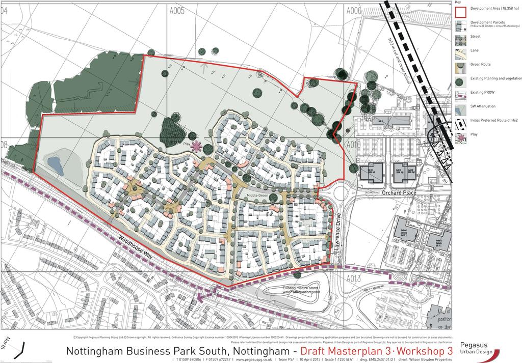
4 1.0 INTRODUCTION 1.1 BWB Consulting Ltd were commissioned by Wilson Bowden Developments Ltd to produce a Transport Assessment and Travel Plan in support of an outline planning application for the change of use of part of the consented Nottingham Business Park (NBP) site for residential use. 1.2 The NBP was granted planning consent, subject to conditions, for 79,091sqm of B1 office and ancillary use in However, only 17,900sqm of B1 office use has been built and occupied, and all of this development has been on the northern half of the NBP site. Current research confirms that the NBP has not achieved the take-up levels initially envisaged. Given this, the available land on the northern half of the site (which can accommodate a further 21,500sqm) provides an adequate supply of B1 land. Therefore, once built out, there will be a total of 39,400sqm of B1 and ancillary use at the site (=17,900sqm existing sqm forthcoming). This is significantly less than the permitted amount of 79,091sqm, and would leave 39,691sqm (=79,091sqm-39,400sqm) of outstanding consented use still to be developed on the southern half of the site 1.3 As a result, Wilson Bowden Developments are now submitting an outline planning application for the change of use of the permitted employment development on the southern half of the NBP site for residential use. The current proposals are for up to 300 dwellings and associated parking, which would replace the remaining 39,691sqm of consented employment development. The development, which is to be known as Woodhouse Park, will predominantly comprise two to five bedroom family homes. A copy of the illustrative residential development masterplan is contained in Appendix A. 1.4 In accordance with the Department for Transport s (DfT) Guidance on Transport Assessment (March 2007), a Travel Plan is required in support of the planning application. A Travel Plan is a long-term management strategy for an occupier or site that seeks to deliver sustainable transport objectives through positive action, and is articulated in a document that is regularly reviewed (DfT s Good Practice Guidelines: Delivering Travel Plans through the Planning Process - April 2009). Furthermore, as noted in NCC s guidance, Travel Plans are an important tool to help deliver safe, accessible and sustainable communities ( Draft Nottingham City Council guidance document for residential Travel Plans - September 2011). 1
5 1.5 A Travel Plan is therefore a living document that sets out ways to reduce the number of vehicle trips generated by a site. It involves the development of agreed targets and outcomes which are linked to an appropriate package of measures aimed at encouraging the use of more sustainable travel modes, whilst also reducing both the need to travel, and single occupancy car use, for all trips to and from the development. The Travel Plan process also includes continuous monitoring, review, and refinement over time, as travel survey data is collected to determine trends in travel patterns. 1.6 A residential Travel Plan is site specific and considers the unique needs and interests of residents, in the context of the local environment and transport network. Residential Travel Plans are concerned with origin-based travel, with journeys made from a single origin (home) to multiple and changing destinations, with the time, and travel mode, all varying. As a result, a successful residential Travel Plan has the potential to achieve a high proportion of trips by sustainable modes and reduce the number of single occupancy car trips generated by the site. 1.7 This Travel Plan includes all of the necessary contents, and predominantly focuses on providing information on the opportunities for travel to and from the site by sustainable modes, to empower residents and visitors alike to take ownership and make informed decisions about their travel choices. The report is structured as follows: Section 2 of the report details the objective of the Travel Plan, and the benefits that it will provide. Section 3 describes the site, the existing local facilities close to the site, and the existing opportunities for travel by foot, cycle, and public transport. The local highway network is also briefly described. Section 4 outlines the development proposals, including the number of dwellings, and the access for vehicles and non-car users. Section 5 details the journey types likely to be generated by the development, the likely number of vehicle and person trips, and the modal split. Section 6 details the initial targets of the Travel Plan Section 7 details the soft measures and incentives that will be implemented to achieve these targets. Section 8 details the methods for implementation, monitoring and review of the Travel Plan. It is explained that the Travel Plan will initially be implemented, monitored, and reviewed by the Travel Plan Co-ordinator, before responsibility is passed on to a Travel Plan steering group. 2
6 1.8 By undertaking this Travel Plan, and implementing and monitoring the measures and incentives proposed in this Travel Plan, Nottingham City Council (NCC), as the local highway authority, should have confidence that the requirements for sustainable travel will be met. 3
7 2.0 OBJECTIVE, AIMS AND BENEFITS 2.1 Objective The overall objective of this Travel Plan is to minimise the number of new car trips generated by residents and visitors travelling to and from the proposed residential development, by promoting and supporting the use of alternative modes of travel (walking, cycling, public transport and car sharing). 2.2 Aims NCC s guidance also states that the main aims of a successful Travel Plan should include the following aims, which are promoted within this Travel Plan: Reductions in car usage (particularly single occupancy journeys) and increased use of public transport, walking and cycling; Reduced traffic speeds and improved road safety and personal security, particularly for pedestrians and cyclists; and More sustainable delivery and freight movements, including home delivery services. 2.3 Benefits and outcomes The DfT s Making Residential Travel Plans Work details potential local benefits that can be achieved when a Travel Plan is designed into a residential development from the beginning. Some of the potential benefits that this Travel Plan will provide for the residents and visitors are listed below: a focused approach to influence the travel behaviour of residents and visitors; the introduction of safe and viable alternatives to single-occupancy car travel, improving both the availability and choice of travel modes to the site, reducing the number of vehicle trips, and reducing vehicle mileage; increased awareness of the potential for, and advantages of, travelling by sustainable modes of travel, including walking, cycling, public transport, and car sharing; increased awareness of the social, environmental, and economic costs of individual travel choices; a positive change in attitudes towards the use of alternative travel modes; provision of practical information on how to travel by more sustainable transport modes, with integration between different transport modes; 4
8 provision of practical initiatives, based on regular appraisal of resident s travel patterns; and improved accessibility, safety, and security for people travelling to, from, and within the site, particularly vulnerable road users, such as children, the elderly, and disabled In addition to these benefits, in line with the Delivering Travel Plans through the Planning Process Good Practice Guidelines, and the DfT s Making Residential Travel Plans Work, the Travel Plan will also seek the following outcomes: reduction in the overall need for travel to and from the site; reduction in the need for car use, with associated benefits in terms of reduced traffic, congestion, air pollution, and accidents; generation of only the minimum number of car movements to and from the development; more attractive environments; supporting the viability of local public transport services and helping reduce social exclusion; increased usage and safety of neighbourhood cycling and walking routes; opportunities provided to build healthy exercise into daily life; represent good practice and provide an educational tool to help change perceptions about the convenience and benefits of not using the car where alternatives exist; and increased marketability of the development as more households seek to change their travel behaviour. 5
9 3.0 EXISTING CONDITIONS 3.1 Site location The NBP is located to the west of the A6002 Woodhouse Way, in the Bilborough ward in Nottingham. The proposed development site comprises the southern part of the consented NBP site. The general and detailed site locations are shown in Figures 1 and 2 respectively. An aerial photograph of the NBP and the proposed development site is shown in Figure Local highway network The existing employment units on the northern half of the NBP site are accessed via the Woodhouse Way/Lawrence Drive/Mellors Way four arm roundabout. Both Lawrence Drive and Mellors Way are subject to a 30mph speed limit and have double yellow lines on both sides of the carriageway to restrict on-street parking In the vicinity of the northern half of the NBP site, Woodhouse Way is a wide single carriageway road with central hatching. To the north-east of the site, Woodhouse Way joins Mornington Crescent (south) via a large priority-controlled T-junction. There is also a TOUCAN crossing on Woodhouse Way to the south of the junction, and further north, Woodhouse Way joins Mornington Crescent (north) via a traffic signal controlled T-junction. Both junctions and the TOUCAN crossing were provided as part of the planning conditions for the consented NBP In the vicinity of the southern half of the NBP site, and thus adjacent to the proposed residential development site, Woodhouse Way is a wide single carriageway road. It is subject to a 40mph speed limit, and does not have any parking restrictions. There is a TOUCAN crossing, with dropped kerbs, tactile paving, and guard railing, adjacent to the link to Lancaster Way, and within the site frontage. The TOUCAN crossing was provided as part of the planning conditions for the consented NBP To the south-east of the site, Woodhouse Way joins Bilborough Road and the B6004 Strelley Road via a large traffic signal controlled crossroad junction. This junction was upgraded as part of the planning conditions for the consented NBP. 6
10 3.3 Opportunities for pedestrian and cycle travel The Institution of Highways and Transportation (IHT) publication Guidelines for Providing for Journeys on Foot [2000] describe acceptable walking distances for pedestrians without mobility impairment. They suggest that for commuters and school pupils, up to 500 metres is the desirable walking distance, up to 1,000 metres is an acceptable walking distance, and up to 2,000 metres is the preferred maximum walking distance In addition, recent guidance suggests the cyclists are typically prepared to cycle up to 5km for non-leisure journeys, such as those to school or work Figure 4 shows the pedestrian catchment area based on 2,000 metres walking distance from the centre of the site, via footways along the local highway network and via traffic free footpaths. As shown, the pedestrian catchment area includes the Broxtowe and Bilborough areas, and the associated employment, education, retail, health and leisure facilities within the Broxtowe area. All of these facilities would help reduce the need for residents to travel by car Figure 5 shows the cycle catchment area. As shown, a 5km distance from the centre of the site includes the western suburbs of Nottingham (Bilborough, Wollaton, Cinderhill, and Bulwell) as well as Nuthall and parts of Ilkeston, and the associated employment, education, retail, health and leisure facilities In terms of facilities local to the site, Figure 6 shows the nearby nursery, infant and primary schools. As shown, the Seagrave, Melbury, Portland, Westbury, Brocklewood, Mornington, and Horsendale Primary Schools are all within walking distance of the site, whilst the Shepherd and Glenbrook Schools are just beyond walking distance but within cycling distance Similarly, Figure 7 shows the nearby secondary schools and colleges. As shown, the Nottingham University Samworth Academy, Denewood Learning Centre, and Bilborough College are all within walking distance of the site. The remaining schools, including the Hadden Park High School, Trinity Catholic School, Woodland School and Manning School for Girls are just beyond 2km walking distance but within the 5km cycling distance Figure 8 shows the nearby employment, health and retail facilities within walking distance of the site. As shown, the employment includes NBP itself as well as Broxtowe Park Business Centre, in addition to several NCC departments and the 7
11 schools and colleges detailed above. The employment opportunities increase further within the 5km cycling catchment area, and include the University of Nottingham and the Queens Medical Centre (QMC). The health facilities include two health centres, a GP surgery and a dentist. The retail facilities within walking distance include a Co-op supermarket and several smaller convenience stores (including a Co-op, Spar and Premier). The retail facilities increase further within the 5km cycling catchment area The site is therefore well located for pedestrian and cycle trips in terms of distances to the nearby education, employment, health and retail facilities With regards to pedestrian and cycle infrastructure, there are wide, street-lit footways provided throughout the constructed parts of NBP, as well as a footway/cycleway that runs diagonally through the NBP and connects to Woodhouse Way to the north east of the proposed development site There is also a wide street-lit segregated footway/cycleway along the eastern side of the A6002 Woodhouse Way to the north-east of the site, which terminates at the existing TOUCAN crossing adjacent to the proposed development site. This was provided as part of the planning conditions for the consented NBP, and is shown in the aerial photographs in Figure 9, and the extract of NCC s Nottingham Cycle Map shown in Figure 10. Directly to the east, there is a wide footway With regards to crossing facilities, there are two TOUCAN crossings on the A6002 adjacent to the NBP site, as detailed in Section 3.2 and shown in Figure 9. These were constructed to discharge the planning conditions for the NBP The existing northern crossing includes appropriate dropped kerbs, tactile paving and guard railing, and accommodates pedestrian trips to and from the north. The southern crossing is smaller, but also includes appropriate dropped kerbs, tactile paving and guard railing. From the TOUCAN crossing, there is a narrow, unlit route connecting through to Lancaster Way. There are wide street-lit footways on both sides of Lancaster Way, which connect to a wider network of footways throughout the residential areas to the east of the site. As shown in Figure 9, Lancaster Way and the connecting routes are designated as roads recommended for cycling, and can therefore be used for trips to and from the east Overall, given the areas and facilities contained within acceptable walking and cycling distance of the site, and the existing pedestrian and cycle infrastructure provided along the desire lines, it is considered that there are good opportunities for pedestrian and cycle travel to and from the site. 8
12 3.4 Accessibility by bus The IHT publication Guidelines for Planning for Public Transport in Developments states that the maximum walking distance to a bus stop should not exceed 400 metres. However, the guidelines also note that the 400 metres walking distance should be treated as guidance, to be achieved where possible by services that operate at regular frequencies and along direct routes. It is more important to provide services that are easy for passengers to understand and are attractive to use than to achieve slavish adherence to some arbitrary criteria for walking distances Paragraph 3.81 of the 6C s Design Guide Highways, Transportation, and Development [November 2011], which is adopted by NCC and NsCC, notes that the walking distance should not be more than 800 metres As indicatively shown in Figure 13, there is one marked bus stop on Lawrence Drive within the NBP. This is in the form of a shelter with seating and timetable information, and is within 400 metres walking distance of the proposed residential development. The bus stop is served by the Worklink 3 (W3) service. The service is one-way, and runs from the city to the NBP in the morning peak period (arriving at 0725, 0745, 0815 and 0845 hours), and returns in the evening peak period (departing from NBP at 1531, 1601, 1645, 1715, 1745 and 1815 hours). Based on a review of the timetable, the existing morning journey takes 30 minutes, and the evening return journey takes 32 minutes. NCC have confirmed that the two buses that run this route are used elsewhere during the day In addition, the Service 33 routes directly passed the site on Woodhouse Way and into the NBP to stop at the bus stop on Lawrence Drive, and is thus within walking distance. Service 33 runs between QMC and Phoenix Park P&R, via Wollaton, Bilborough College and Assarts Farm. From the QMC, there are a number of bus services routing into the city centre, allowing onward travel. In addition, there are opportunities to use the tram to travel to and from the city centre, at Phoenix Park and Bulwell. The Service 33 runs at an hourly frequency in each direction, between 0645 and 1848 from Monday to Saturday In addition, as shown in Figure 13, there are bus stops on both Cranwell Road and Barwell Drive, directly to the east of the site, and within walking distance. These bus stops are in the form of a flag and pole, and are approximately 350 metres walking distance from the centre of the proposed residential development site on the southern half of the NBP. 9
13 3.4.6 These bus stops are served by the Local Link 3 (L3). Service L3 runs between the QMC and Strelley at a frequency of one bus per hour between approximately 0930 and 1630 hours Further east, there are also several bus stops on Flamsteed Road. Flamsteed Road acts a public transport corridor catering for a number of bus services. The bus stops on Flamsteed Road are approximately 750 metres walking distance from the centre of the proposed residential development site. Hence, in accordance with the 6C s design guidance, the bus stops are within walking distance of the majority of the site, although beyond the recommended 400 metres The bus stops are in the form of shelters with seating and timetable information, and include raised kerbs with tactile paving. Public transport users would be able to access the bus stops on Cranwell Road and Flamsteed Road via the TOUCAN crossing on the A6002, and along the footways on Lancaster Way The bus stops are served by Services 76, 77/77C/N77, and 78. The services run between the city centre and Strelley, with Services 77 and 78 being the most regular and frequent Service 77 runs every 7-10 minutes throughout the day from approximately 0500 to 2330 hours from Monday to Saturday (with the N77 running hourly through the night). The Service 77 runs at a 15 minute frequency on Sundays Service 78 runs every 15 minutes throughout the day from approximately 0630 to 2330 hours from Monday to Saturday. The Service runs at an hourly frequency on Sundays Overall, from Monday to Friday, there are limited bus services in the morning and evening peak periods within 400 metres walking distance of the site. This is because the W3 is one-way, whilst the L3 does not operate in the peak hours, and the Service 33 runs on an hourly frequency. However, there are in excess of 11 bus services, or one bus every 5 minutes, on Flamsteed Road, approximately 750 metres from the site. There are therefore some are opportunities for bus travel to and from the development. However, as noted by NCC, this must be improved as part of the proposed residential development. This is detailed further in Section 4. 10
14 3.5 Summary The proposed development site comprises the southern half of the consented NBP. The site is accessible by a range of sustainable travel modes. Given the areas contained within acceptable walking distance of the site, and the existing pedestrian infrastructure including footways and crossings, there are good opportunities for pedestrian travel. Similarly, given the areas contained within cycling distance and the existing cycle infrastructure, including off-road cycle routes and TOUCAN crossings, there are good opportunities for cycle travel between the site and the local area. In addition, there are some opportunities for public transport travel, with one bus per hour within 400 metres walking distance and approximately one bus service every five minutes within 750 metres walking distance of the site. There are a number of education, employment, health and retail facilities within walking and cycling distance of the site. As a result, the proposed development is well located for residential development Nevertheless, sustainable travel measures will be provided as part of the development proposals to increase the accessibility of the site for pedestrians, cyclists and public transport users. This is detailed further in Section 4. 11
15 4.0 PROPOSED DEVELOPMENT 4.1 Development proposals The development proposals comprise the replacement of 39,691sqm of consented employment use with up to 300 new residential dwellings on the southern half of the NBP site The proposed residential development will comprise a mix of 2, 3, 4, and 5 bedroom houses, including some affordable housing and elderly person s bungalows. A copy of the proposed development illustrative masterplan is contained in Appendix A It is understood that the proposed development will be constructed in phases, with a build rate of approximately 50 dwellings per year. It will therefore take approximately six years to complete the development. It is understood that the first phase of the residential development will be accessed from Woodhouse Way, and that the link road connecting through to Lawrence Drive will be built as part of phase 3 to Parking Given that the application is outline only, it is not necessary to specify the exact number of allocated and unallocated car parking spaces that will be provided as part of the residential development Nevertheless, the car parking provision will be provided in accordance with the likely car parking demand, to prevent any unnecessary on-street parking within the site and any off-site parking The forecast parking demand will be calculated using the Department for Communities and Local Government Residential Car Parking Research (May 2007), as required in the 6C s Design Guide Highways, Transportation and Development (November 2011). This method calculates the likely car parking demand based on the dwelling size, type and tenure, the location and local levels of car ownership, and the number of allocated and unallocated parking spaces In accordance with NCC s guidance, consideration will be given to the provision of charging points for electric vehicles, should this be required in the future. This 12
16 would be designed with advice from NCC, and could be implemented with the funding support that is potentially available In addition, the majority of houses will have garages and space to provide secure cycle parking. 4.3 Access As shown in the masterplan contained in Appendix A, the proposed development will be accessed via the existing Woodhouse Way/Lawrence Drive/Mellors Way roundabout, and via a new traffic signal controlled T-junction on Woodhouse Way. The two accesses will be connected via an internal link road The proposed Woodhouse Way/site access signal controlled junction is shown in Drawing WBP/274/001 revision P3. As shown, the junction will include pedestrian crossing facilities on the site access and Woodhouse Way (N) arms. The site access arm will also include a 45m cycle lead-in lane and advanced cycle stop line. Cyclists travelling to and from the north and south will therefore be able to use the advanced cycle stop line and cycle on the Woodhouse Way carriageway In addition to the main site access junctions and the internal link road, a smaller, low-key junction is proposed on Lawrence Drive, in the vicinity of the existing public right of way. As discussed and agreed with NCC, this route will provide a shared surface arrangement, and will be lightly trafficked with limited access taken from it. 4.4 Sustainable travel As part of the development proposals, footways will be provided on both sides of the internal link road. These will connect to the existing infrastructure on Lawrence Drive and, via a new crossing, on Woodhouse Way. Away from the main spine road, the proposed development will include roads with footways on one side only, and roads with a shared surface arrangement The proposed Woodhouse Way/site access signal controlled junction will include pedestrian crossing facilities, with dropped kerbs and tactile paving on the Woodhouse Way (N) and site access arms. 13
17 4.4.3 In addition, a pedestrian only route will be provided through to Lawrence Drive, to facilitate both pedestrian journeys and journeys to and from the existing bus stop on Lawrence Drive As part of the development proposals, it is also proposed to provide funding towards improved bus services at the site. The public transport improvement strategy is based on discussions held with NCC s Public Transport Officer, Mark Garlick, between February and May As a result of these discussions, it is proposed that as part of the development proposals, funding will be provided to improve the W3 so that it runs on a twoway basis in the peak periods, at an approximate frequency of one bus every 30 minutes. The W3 will also be extended to run on a two-way basis throughout the day (i.e. the inter-peak between 0900 and 1600 hours), at a frequency of one bus per hour. The improved W3 will be diverted along the link road through the site, and will be a benefit to both new residents at the development, and existing bus users along the length of the W3 route The proposed funding will be provided for two and a half years from first occupation, and build upon the existing funding already provided as part of the NBP development, as well as the funding currently provided by NCC to support the existing service. Based on the calculations of likely revenue generation (both within the development and from public transport users along the length of the W3 bus route), the W3 will be fully commercial (self-funding) at the end of the funding period In addition, as part of the public transport improvement strategy, it is proposed to maintain the Service 33 at its existing frequency, but to divert it through the site once the internal link road has been built (instead of routing up and down Lawrence Drive as currently occurs) As a result of these improvements, there will be a total of three bus services per hour (approximately one every 20 minutes) in the peak periods, and two bus services per hour (approximately one every 30 minutes) running through the development and thus within 400 metres of every new dwelling In addition to the bus contributions, one pair of bus stops, with raised kerbs, shelters, seating and timetable information will be provided within the development site to ensure that every dwelling is within 400 metres walking distance of a bus stop. These bus stops will allow access to both the W3 and the 14
18 33. Until the link road comes forward, a temporary bus stop will be provided on Woodhouse Way to accommodate bus users within the first phases of the development. This will include appropriate dropped/raised kerbs, and a shelter with timetable information. Once the link road has been constructed, this bus stop will be removed In accordance with NCC s guidance, in order to help reduce the need for residents to travel, consideration will be given to the provision of high speed broadband within the dwellings. This would allow residents to work at home/undertake home shopping etc and thus reduce the need to travel In addition, in accordance with NCC s guidance, consideration will also be given to the provision of not at home delivery schemes. This could comprise individual or communal areas where deliveries can be left securely when the resident is not able to receive them in person. 15
19 5.0 TRIP GENERATION AND MODAL SPLIT 5.1 Introduction As detailed in Section 1, residential Travel Plans are concerned with origin-based travel, with journeys made from a single origin (home) to multiple and changing destinations, with the time, destinations and travel mode all varying Nevertheless, there will be four main types of journeys made to and from the development, as follows: journeys from home to work journeys from home to education journeys for leisure/recreation purposes, including non-food shopping journeys from home to food shops. 5.2 Vehicle trips The Transport Assessment identified that the proposed development would generate the following peak hour vehicle trip rates (per dwelling): 0800 to 0900 hours arrive depart two-way 1700 to 1800 hours arrive depart two-way Based on these trip rates, the proposed development with 300 dwellings, could generate the following vehicle movements: 0800 to 0900 hours 53 arrive 157 depart 210 two-way 1700 to 1800 hours 149 arrive 107 depart 255 two-way However, these figures do not take into account the effect of this Travel Plan on the vehicle trip generation of the site. 5.3 Modal split and person trip generation Using the mode of travel to work data from the 2011 National Census, the Transport Assessment suggests that the following modal split will occur at the residential development: pedestrians 7.0% cyclist 2.2% bus 14.5% tram 1.7% 16
20 train 0.4% motorcycle 0.9% taxi 0.5% vehicle drivers 67.1% vehicle passengers 5.7% Based on this modal split, the proposed development with 300 dwellings, would generate the following peak hour two-way person trips: Car driver Passenger Motorcycle Bus Train Tram Bicycle On foot 67.1% 6.2% 0.9% 14.5% 0.4% 1.7% 2.2% 7.0% The above modal split and person trip generation does not take into account the effects of this Travel Plan. Nevertheless, it is considered that the existing and proposed routes in and around the site would be able to accommodate the increase in pedestrian, cycle and public transport movements. 17
21 6.0 TARGETS 6.1 Introduction Section detailed the likely modal split and person trip generation of the development. The modal split shows a car driver proportion of 67.1%, and a single occupancy car driver proportion of 60.9% (= 67.1% - 6.2% passengers) However, there is significant evidence to suggest that Travel Plans, and the promotion of sustainable travel modes, have a significant impact on the modal split of a development and the proportion of car trips Section Four of DfT s Guidance on the Assessment of Travel Plans (December, 2005), is entitled Developing credible Travel Plan targets. Paragraph 4.4 of the guidance states that once the baseline modal split has been established, i.e. the modal split that would occur if there was no Travel Plan in place, (as detailed in Section 5.3.1), the next step is to establish how the Travel Plan could reduce car use The guidance notes that a strong relationship exists between the potential for changes to the modal split and the measures and incentives proposed in the Travel Plan, and therefore provides guidance on the setting of appropriate and realistic targets. The relationship is as follows: a plan containing only marketing and promotion is unlikely to achieve any modal shift a plan with the above plus car sharing and cycle measures could achieve a 3-5% reduction in drive alone commuting a plan with the above measures plus discounts on public transport, works buses, additional public transport links, could achieve around a 10% reduction the combination of all of the above measures plus disincentives to car use could achieve a 15-30% reduction in drive alone commuting The guidance notes that only in very exceptional cases will the reduction be greater than this. The document that this quote is taken from has since been archived. Nevertheless, it is considered that the research findings are still relevant, and that it helps put the targets proposed in this report into context In addition, reference was made to the more recent The Effects of Smarter Choice Programmes in the Sustainable Travel Towns report (February, 2010). In 18
22 summary, Darlington, Peterborough, and Worcester implemented a programme of measures between 2004 and 2009 with the aim to reduce car use. A key finding was that car driver trips per resident of the three towns together fell by 9% between 2004 and Proposed targets In line with the above research, the following targets will be in place from the outset: Target 1 - The development will have 100% Travel Plan awareness (this is detailed further in Section below) Target 2 - The development will promote the opportunities and benefits of sustainable modes of travel, with the aim to achieve a 15% reduction in the single occupancy vehicle car driver modal share, by the end of the five year post occupation monitoring period With regards to Target 1, every resident between the age of 16 and 74 years is to be aware of the objective of the Travel Plan, how to contact their Travel Plan Coordinator, and that the Travel Plan Co-ordinator can advise residents on alternative travel options for all types of journeys, within two weeks of moving to the development With regards to Target 2, the 15% reduction in the single occupancy vehicle trips will be complimented by an increase in the proportion of walking, cycling, public transport and car sharing travel modes, and also by a reduction in overall travel To quantify, a 15% reduction in the 60.9% single occupancy vehicle car driver modal share will equate to a 9.1% reduction, and thus a single occupancy car driver modal share of 51.7% In terms of vehicle trip generation, a 15% reduction in the number of single occupancy car trips will equate to the following maximum number of single occupancy car trips being generated by the 300 dwellings, calculated as follows: AM PM Arrive Depart 2-way Arrive Depart 2-way Vehicle trip generation from Section 5 (includes vehicles with passengers) Total number of vehicles with passengers (modal split from Section 5.3.1) Total number of single occupancy vehicles (excluding vehicles with passengers) Total number of single occupancy vehicles with 10% reduction in place Number of single occupancy drivers shifted
23 7.0 MEASURES AND INCENTIVES 7.1 Introduction As concluded in Section 3, the site is in a sustainable location, with opportunities for travel by foot, cycle, and public transport. As detailed in Section 4, the provision of footways through the site, an additional pedestrian crossing on Woodhouse Way at the proposed site access junction, and the provision of a new bus service through the site and bus stops within the site will further improve this In addition, to these hard measures, further soft measures will be implemented by the Developers prior to and during occupation, in order to promote and further support the use of sustainable travel modes, including walking, cycling, public transport use, and car sharing. As detailed in Section 1, the measures focus on providing residents with the appropriate information to empower them to make informed decisions about their travel choices This promotion will be undertaken in a sensitive manner, so that it is not viewed as oppressive by residents, but rather as a helpful, informative process which allows them to make informed decisions on their selected transport mode and the benefits of each mode. This is vitally important in order to avoid any potential for residents to view this process as overbearing and intrusive. 7.2 Developer commitments The following measures will be funded and implemented by the Developers during the construction process and prior to occupation: Appointment of the Travel Plan Co-ordinator, to co-ordinate the implementation and monitoring of the Travel Plan. The Travel Plan Coordinator role will be undertaken by a Sales Advisor. The role will commence when the construction of the first residential dwelling begins until one year after the occupation of the final dwelling. The Travel Plan Co-ordinator will therefore be involved throughout the construction, marketing, sale/rent, and occupation processes. The Travel Plan Co-ordinator will then give a Travel Plan briefing to all other sales/marketing staff associated with the development. This will involve the Travel Plan Co-ordinator explaining the Travel Plan and the travel opportunities at the site to their other sales/marketing staff, so that they can also inform all potential residents about the Travel Plan process, and answer 20
24 any questions that they may have. This will help to ensure that the residents are fully aware of the Travel Plan process when they buy/rent the dwellings. The Travel Plan will be promoted in the marketing and promotion of the site. The green transport credentials of the site will be sold as an attractive benefit for new residents. Provide funding for travel welcome packs for each household, containing walking, cycling and public transport information, to promote the use of these modes, and also where possible, reduce the need to travel. The travel welcome packs will be compiled by the Travel Plan Co-ordinator prior to first occupation, and issued by the Travel Plan Co-ordinator to residents on occupation, as detailed in Section 7.3. Provide funding for each household that has purchased a dwelling to be supplied with a voucher for two free six month public transport passes (for example, Kangaroo passes, which are multi-modal and suitable for bus, tram and train travel). Given the nature of the targets proposed within this Travel Plan, the vouchers will only be issued to households that could realistically use public transport for their journeys to and from work or school in the morning and evening peak periods. 7.3 Travel Plan Co-ordinator commitments The following measures will be undertaken by the Travel Plan Co-ordinator following occupation, in order to maintain Travel Plan promotion and awareness raising: Induction sessions for new households. o Each newly occupied home will receive a voluntary induction visit, at which their Travel Plan Co-ordinator makes contact, takes the householders through the travel opportunities of the site, and explains about the Travel Planning process. o The Travel Plan Co-ordinator will also explain how households in the newly purchased dwellings can request the voucher the two free six month public transport passes. This includes explaining that the voucher scheme is available to households that could realistically use public transport to travel to and from work or school in the morning and evening peak periods. 21
25 Travel Welcome Packs, given to residents by the Travel Plan Co-ordinator upon occupation. These will be funded by the Developer 1, and produced by the Travel Plan Co-ordinator: o Promotional information on the benefits of walking, cycling, public transport use, and car sharing, and the social, environmental and economic costs of each mode. o A pedestrian route map to key destinations, such as local shops and schools etc, with distances and journey times. o A cycle route map to key destinations, with distances and journey times. The map will also show the location of any public cycle parking facilities. o Public transport information, including a bus route map, and the latest bus and rail timetables. The Welcome Pack will also include details of the range of tickets available, and the costs of these tickets. Contact details where further information can be obtained, including website addresses, will also be included. o Contact details and a location map showing local car hire firms, and taxi companies, based on postcode information. o Information about the benefits of car sharing, and references to the excel spreadsheet on which calculates how much individual s spend on motoring, and how much they would save by car sharing. o Advertise details of relevant car share schemes, such as and o Contact details of local supermarkets and retail outlets that provide a home delivery service. This would result in a reduction in the need to travel. o Information about home working and home shopping. o Contact details of the Travel Plan Co-ordinator, and NCC s Travel Plan Officer To facilitate continued promotion and awareness raising, the Travel Plan Coordinator will also act as a point of contact for all residents and visitors requiring information. The Travel Plan Co-ordinator will promote national events, such as national bike to work week and walk to work day. Where necessary, the Travel Plan Co-ordinator will direct residents to contact NCC s Travel Plan Officer for 1 Funding will be provided by the developer, but as stated within NCC s guidance some assistance in the form of access to existing services and marketing material may be available from Nottingham City Council, partners and transport operators. 22
26 further information and advice. The Travel Plan Officer s contact details are as follows: Matthew Price Nottingham City Council 4 th Floor Loxley House Station Street Nottingham NG2 3NG Tel: matthew.price@nottingham.gov.uk 23
27 8.0 IMPLEMENTATION AND MONITORING 8.1 Implementation The Travel Plan Co-ordinator will initially be responsible for introducing the Travel Plan to the prospective/confirmed residents. Full contact details of the Travel Plan Co-ordinator, including their name, addresses (postal and ) and telephone number, will be supplied to NCC as soon as they are appointed. NCC will be informed of any changes to the Travel Plan Co-ordinator contact details, which may occur for whatever reason The role of the Travel Plan Co-ordinator, which will begin from the date construction first begins until one year after the occupation of the final dwelling, will be to: promote the Travel Plan to potential and confirmed residents; act as a point of contact for all residents and visitors requiring information represent the human face of the Travel Plan explaining the purpose and the opportunities on offer, including the travel welcome packs and the induction sessions; and take a key role in the monitoring and review of the Travel Plan The Travel Plan Co-ordinator will also need to: liaise with sales and marketing staff regarding the Travel Plan, so that they can also promote it as a positive extra benefit for new residents; liaise with sales and marketing staff so that they are fully informed each time a dwelling is sold/rented, and when the new household will move in, in order to allow them to arrange the induction session/delivery of the travel welcome pack; liaise with the Travel Plan Co-ordinator at the NBP In accordance with NCC s guidance, to assist in the management of a successful Travel Plan, the transition of ownership and responsibility should be planned prior to site occupation. Whilst the developer may not remain involved in the day to day operation of the travel plan following occupation, they will remain ultimately responsible for its success or failure. Therefore, towards the end of their role, the Travel Plan Co-ordinator will seek to establish a Travel Plan Steering Group, to demonstrate ongoing community responsibility for sustainable travel. The Steering Group will be created to allow the residents to continue to pursue the sustainable travel objectives and services long after the Travel Plan Co-ordinator role ceases (one year after last occupation). It is envisaged that the Steering 24
28 Group will comprise local residents, and a representative from NCC will also be invited to join. Given that this Travel Plan focuses on providing residents with information to make informed decisions, any measures and incentives required to achieve and maintain a positive modal split and a reduced number of vehicle trips will be minimal. Therefore, the role of the Steering Group will mainly be to coordinate the monitoring and review strategies, and produce the Annual Monitoring Reports (see Section 8.2). 8.2 Monitoring The majority of measures to reduce car use, and promote walking, cycling, public transport, and car sharing will be in implemented during the construction process, or within one month of occupation. This will allow residents to assess the potential to travel by alternative modes of travel, and allow a sustainable travel culture to emerge from the start In order to monitor the Travel Plans, travel surveys will be undertaken at each household within three months of their occupation. They will therefore be undertaken as part of a wider post-occupation survey process undertaken by the Travel Plan Co-ordinator to ensure that they receive feedback on the development from the new occupants. This will be more efficient and result in a higher response rate than waiting until one year after initial occupation The surveys will be produced by the Travel Plan Co-ordinator, and would determine the baseline modal split and travel patterns of each household, and thus at the site as a whole, the uptake of any measures and incentives proposed in this Travel Plan (including the uptake of the voluntary induction visits, and the free vouchers), and help identify any further measures that need to be investigated and proposed A monitoring report will be compiled by the Travel Plan Co-ordinator once 50 dwellings are occupied, using the results of the surveys completed to date The surveys and monitoring report will then be completed again in a neutral month the following year and on an annual basis for five years, and the results summarised and issued to NCC. The report will include an introduction, the annual survey results including analysis of trends against previous years, and brief details of measures implemented throughout the year The Monitoring Reports and hence details of the survey results will be issued to the residents by the Travel Plan Co-ordinator to ensure residents are aware of the progress being made by the Travel Plan. This will also help to ensure that 25
29 residents are engaged in the plan and encouraged to take on increasing responsibility for its delivery Remedial measures could be implemented in the event of a shortfall in the progress towards agreed targets. These could include: extending the role and responsibilities of the Travel Plan Co-ordinator; relaunching the Travel Plan; providing additional promotional activities to promote sustainable travel; and other Travel Plan measures. However, such measures should not be required because, as detailed in Section 1, a Travel Plan is a living document, and therefore, in accordance with DfT s guidance, effective review mechanisms should enable the plan to be adjusted and avoid the need for invoking any default mechanisms or resorting to enforcement action. 26


30 N Consented Nottingham Business Park site Land for proposed residential development 1km Project Title WOODHOUSE PLACE, NOTTINGHAM General site location BWB Consulting Ltd Fifth Floor Waterfront House 35 Station Street Nottingham NG2 3DQ Tel: FAX: Project No. Drawn Checked Scale Drg. No. WBP474 RE Approved DAC PW Date AS SHOWN FIGURE 1

31 WOODHOUSE WAY N Consented Nottingham Business Park boundary Land proposed for residential development 250m Project Title WOODHOUSE PLACE, NOTTINGHAM Detailed site location BWB Consulting Ltd Fifth Floor Waterfront House 35 Station Street Nottingham NG2 3DQ Tel: FAX: Project No. Drawn Checked Scale Drg. No. WBP474 RE Approved DAC PW Date AS SHOWN FIGURE 2
 Land proposed for residential development (300 dwellings proposed to replace 39,691sqm consented")

32 N Consented Nottingham Business Park boundary (79,091sqm consented but only 17,900sqm built so far) Indicative areas for consented B1 development to be built (21,500sqm forthcoming) Land proposed for residential development (300 dwellings proposed to replace 39,691sqm consented B1 development) Project Title WOODHOUSE PLACE, NOTTINGHAM Aerial photograph BWB Consulting Ltd Fifth Floor Waterfront House 35 Station Street Nottingham NG2 3DQ Tel: FAX: Project No. Drawn Checked Scale Drg. No. WBP474 RE Approved DAC PW Date AS SHOWN FIGURE 3

33 20 N 11 1, 3, 16, , SITE 5, KEY 4, 13, 18, 19 Slight Serious Fatal 7, 9 Project Title WOODHOUSE PLACE, NOTTINGHAM Location of recorded PIAs BWB Consulting Ltd Fifth Floor Waterfront House 35 Station Street Nottingham NG2 3DQ Tel: FAX: Project No. Drawn Checked Scale Drg. No. WBP474 RE Approved DAC PW Date AS SHOWN FIGURE 4
34 N 2km Land proposed for residential development Project Title WOODHOUSE PLACE, NOTTINGHAM Pedestrian catchment area BWB Consulting Ltd Fifth Floor Waterfront House 35 Station Street Nottingham NG2 3DQ Tel: FAX: Project No. Drawn Checked Scale Drg. No. WBP474 RE Approved DAC PW Date AS SHOWN FIGURE 5


35 N 5km SITE Project Title WOODHOUSE PLACE, NOTTINGHAM Cyclist catchment area BWB Consulting Ltd Fifth Floor Waterfront House 35 Station Street Nottingham NG2 3DQ Tel: FAX: Project No. Drawn Checked Scale Drg. No. WBP474 RE Approved DAC PW Date AS SHOWN FIGURE 6
36 N 7 8 KEY Consented Nottingham Business Park boundary 1. Seagrave Primary School 2. Melbury Primary School 3. Westbury School (7-16yrs) 4. Brocklewood (Nursery, Infant and Junior Schools) 5. Shepherd School 1 6. Glenbrook Nursery and Primary School Land proposed for residential development 7. Mornington Primary School 8. Horsendale Primary School 9. Portland Primary School (just south of Bilborough College) km Project Title WOODHOUSE PLACE, NOTTINGHAM Local primary schools BWB Consulting Ltd Fifth Floor Waterfront House 35 Station Street Nottingham NG2 3DQ Tel: FAX: Project No. Drawn Checked Scale Drg. No. WBP474 RE Approved DAC PW Date AS SHOWN FIGURE 7 6
 7. Bilborough College 8.")

37 N KEY 1. Hadden Park High School 2. The Trinity Catholic School 3. Woodland School (3-16yrs) 4. Manning School for Girls 5. Ellis Guildford School 6. Nottingham University Samworth Academy (11-19yrs) 7. Bilborough College 8. Denewood Learning Centre (5-18yrs) 5 Land proposed for residential development 2km km Project Title WOODHOUSE PLACE, NOTTINGHAM Local secondary schools and colleges BWB Consulting Ltd Fifth Floor Waterfront House 35 Station Street Nottingham NG2 3DQ Tel: FAX: Project No. Drawn Checked Scale Drg. No. WBP474 RE Approved DAC PW Date AS SHOWN FIGURE 8

38 KEY N Premier Supermarket Strelley (convenience store) 2. Co-op supermarket 3. Woodfield Stores (convenience store) 4. Spar 5. Nottingham Business Park 6. Broxtowe Park Business Centre 7. RHR Medical Centre 5 8. Doctors surgery 9. Strelley Health Centre 10. Smilestyle Dental Centre 6 7 Land proposed for residential development m Project Title WOODHOUSE PLACE, NOTTINGHAM Retail, employment and health facilities BWB Consulting Ltd Fifth Floor Waterfront House 35 Station Street Nottingham NG2 3DQ Tel: FAX: Project No. Drawn Checked Scale Drg. No. WBP474 RE Approved DAC PW Date AS SHOWN FIGURE 9


39 N Footway/cycleway Land proposed for residential development 500m Project Title WOODHOUSE PLACE, NOTTINGHAM Pedestrian/cycle infrastructure BWB Consulting Ltd Fifth Floor Waterfront House 35 Station Street Nottingham NG2 3DQ Tel: FAX: Project No. Drawn Checked Scale Drg. No. WBP474 RE Approved DAC PW Date NTS FIGURE 10


40 N Land proposed for residential development Project Title WOODHOUSE PLACE, NOTTINGHAM Extract of NCC s cycle map BWB Consulting Ltd Fifth Floor Waterfront House 35 Station Street Nottingham NG2 3DQ Tel: FAX: Project No. Drawn Checked Scale Drg. No. WBP474 RE Approved DAC PW Date AS SHOWN FIGURE 11

41 N KEY 28/N28 SITE 33 35/35B c N77 78 L3 L11 W3 Bus stops Project Title WOODHOUSE PLACE, NOTTINGHAM Local bus services BWB Consulting Ltd Fifth Floor Waterfront House 35 Station Street Nottingham NG2 3DQ Tel: FAX: Project No. Drawn Checked Scale Drg. No. WBP474 RE Approved DAC PW Date AS SHOWN FIGURE 12
42 E E E F G F G F G H H H WILSON BOWDEN DEVELOPMENTS NOTTINGHAM BUSINESS PARK PROPOSED SIGNAL CONTROLLED ACCESS FROM WOODHOUSE WAY PRELIMINARY WBP/474/001 P3
43 APPENDIX A PROPOSED DEVELOPMENT ILLUSTRATIVE MASTERPLAN
44


45 1
Proposed Lidl Food store West Hendford, Yeovil
 Proposed Lidl Food store West Hendford, Yeovil Lidl Travel Plan October 2015 CONTENTS Page 1.0 INTRODUCTION 1 1.1 Background 1 1.2 Aim of Travel Plan 1 1.3 Contents 2 2.0 TRANSPORT CONTEXT 3 2.1 Site Location
Movement Strategy. November On behalf of Barton Oxford LLP
 Movement Strategy November 2014 On behalf of Barton Oxford LLP BARTON PARK, OXFORD. Movement Strategy 17/11/2014 Quality Management Issue/revision Issue 1 Revision 1 Revision 2 Revision 3 Remarks Date
Scotchbarn Lane, Prescot Accessibility Statement
 Scotchbarn Lane, Prescot Accessibility Statement Lancashire Mortgage Corporation Ltd August 2012 Issue R001B 9X0789 All rights reserved. No part of this publication may be reproduced in any form, including
Roundhouse Way Transport Interchange (Part of NATS City Centre Package)
") Roundhouse Way Transport Interchange (Part of NATS City Centre Package) 15/16 16/17 17/18 18/19 19/20 Total TOTAL COST Roundhouse Way Transport Interchange 0.5m 0.5m FUNDING CIL 0.05m 0.05m Growth Deal
Roundhouse Way Transport Interchange (Part of NATS City Centre Package) 15/16 16/17 17/18 18/19 19/20 Total TOTAL COST Roundhouse Way Transport Interchange 0.5m 0.5m FUNDING CIL 0.05m 0.05m Growth Deal
Riverside Heights, Norwich. Travel Plan
 RIVERSIDE HEIGHTS, NORWICH Client: Engineer: Taylor Wimpey East Anglia Create Consulting Engineers Limited Hungate House Princes Street Norwich Norfolk NR3 1AZ Tel: 08454507908 Email: enquiries@createconsultingengineers.co.uk
TRANSPORT FOR GREATER MANCHESTER COMMITTEE REPORT FOR RESOLUTION
 TRANSPORT FOR GREATER MANCHESTER COMMITTEE REPORT FOR RESOLUTION DATE: 11 November 2011 SUBJECT: REPORT OF: Proposed making of a Quality Partnership Scheme for the A6 corridor between Manchester and Hazel
Cuadrilla Elswick Ltd
 Cuadrilla Elswick Ltd Tewmporary Shale Gas Exploration Description Roseacre Wood, Lancashire Planning Inspectorate Reference APP/Q2371/W/15/3134385 Local Authority Reference: LCC/2014/0101 CE 1/3 Summary
A Response to: Belfast On The Move Transport Masterplan for Belfast City Centre, Sustainable Transport Enabling Measures
 West Belfast Partnership 218-226 Falls Road Belfast BT12 6AH T: 02890809202 A Response to: Belfast On The Move Transport Masterplan for Belfast City Centre, Sustainable Transport Enabling Measures Issued
Guildford Borough Transport Strategy 2017, Topic Paper: Transport, June 2017 (accompanying Local Plan 2017) Local Plan Transport Strategy 2017
 Local Plan Transport Strategy 2017") Guildford Society Transport Group Position Paper August 2017 Based on submissions in response to the June/July 2017 Local Plan consultation including material presented to Drop-in Session 15 July 2017.
Guildford Society Transport Group Position Paper August 2017 Based on submissions in response to the June/July 2017 Local Plan consultation including material presented to Drop-in Session 15 July 2017.
Major Scheme Business Case Summary Report for Programme Entry
 Paper A Heart of South West Local Transport Board Major Scheme Business Case Summary Report for Programme Entry M5 Junction 25, Taunton July 2016 1 SCHEME SUMMARY Scheme Name M5 Junction 25, Taunton Date
John Betts School Crossing Review
 John Betts School Crossing Review Paddenswick Road London Borough of Hammersmith & Fulham August 2015 DOCUMENT CONTROL Project Centre has prepared this report in accordance with the instructions from the
Saighton Camp, Chester. Technical Note: Impact of Boughton Heath S278 Works upon the operation of the Local Highway Network
 Technical Note: Impact of Boughton Heath S278 Works July 2013 SAIGHTON CAMP CHESTER COMMERCIAL ESTATES GROUP TECHNICAL NOTE: IMPACT OF BOUGHTON HEATH S278 WORKS UPON THE OPERATION OF THE LOCAL HIGHWAY
Citycourt Developments Ltd
 ouse Citycourt Developments Ltd Proposed Lidl Foodstore,, Dover Interim Travel Plan REPORT CONTROL Document: Travel Plan Project: Client: Citycourt Developments Ltd Job Number: 152045 File Origin: Document
Commissioning Director - Environment
 Finchley and Golders Green Area Committee 27 April 2017 Title Report of Wards Status Urgent Key Enclosures Summers Lane,N12 Request for Pedestrian Improvements Commissioning Director - Environment Woodhouse
Environment Committee 24 September 2015
 Environment Committee 24 September 2015 Title Enforcement of Single Yellow Lines on Bank Holidays Report of Commissioning Director - Environment Wards All Status Public Urgent No Enclosures Key No Appendix
Gold Coast. Rapid Transit. Chapter twelve Social impact. Chapter content
 Gold Coast Rapid Transit Chapter twelve Social impact Chapter content Social impact assessment process...235 Existing community profile...237 Consultation...238 Social impacts and mitigation strategies...239
Haworth Tr T avel Plan r 10th February 2006
 Haworth Travel Plan 10th February 2006 Haworth Travel Plan has been prepared for: Contents 1 Why have Haworth Travel Plan?... 3 2 Who will benefit from Haworth Travel Plan?... 4 3 What actions will be
Proposals for the Harrogate Road / New Line Junction Improvement Scheme. August / September Supported by:
 Proposals for the Harrogate / New Line Junction Improvement Scheme August / September 2016 Supported by: Introduction Key Benefits Proposals are currently being developed for changes to the junction of
Open Report on behalf of Richard Wills, Executive Director for Environment and Economy
 Agenda Item 7 Executive Open Report on behalf of Richard Wills, Executive Director for Environment and Economy Report to: Executive Date: 02 September 2014 Subject: Lincoln East West Link Road Phase 1
Chapter 6 Route Window NE5 Seven Kings station. Transport for London
 Chapter 6 Route Window NE5 Seven Kings station Transport SEVEN KINGS STATION 6 Route Window NE5 Seven Kings Station Transport Introduction 6.1 All construction activities in this route window are associated
Queen s Circus Roundabout
 Stage 2 Road Safety Audit Ref: 1128-RSA-01 Prepared for: Steer Davies Gleave By: Capital Traffic Prepared by: Checked by: Approved by: Andy Haunton, Audit Team Leader Jonathan Thompson, Audit Team Member
Arcadis LLP Proposed Secondary School (Bolder Academy) Macfarlane Lane, Isleworth Access Management Strategy. June 2017
 Macfarlane Lane, Isleworth Access Management Strategy. June 2017") traffic engineering and transport planning Arcadis LLP Proposed Secondary School () June 2017 Armstrong House, The Flemingate Centre, Beverley, HU17 0NW 01482 679 911 info@local-transport-projects.co.uk
traffic engineering and transport planning Arcadis LLP Proposed Secondary School () June 2017 Armstrong House, The Flemingate Centre, Beverley, HU17 0NW 01482 679 911 info@local-transport-projects.co.uk
20mph Speed Limit Zones
 Traffic Advisory Leaflet 7/91 May 1991 20mph Speed Limit Zones Summary This leaflet illustrates the main steps in the procedures for the implementation of 20mph zones. It provides brief details on: the
London Borough of Barnet Traffic & Development Design Team
 London Borough of Barnet Traffic & Development Design Team AERODROME ROAD PEDESTRIAN FACILITY AND BUS STOP INTRODUCTION FEASIBILITY REPORT Job Number: 60668 Doc Ref: S106/12-13/60668 Author: Manoj Kalair
Report to: Greater Cambridge Partnership Joint Assembly 18 January A10 Foxton level crossing bypass and travel hub
 Report to: Greater Cambridge Partnership Joint Assembly 18 January 2018 Lead officer: Chris Tunstall GCP Director of Transport A10 Foxton level crossing bypass and travel hub 1. Purpose 1.1 The list of
5 Rail demand in Western Sydney
 5 Rail demand in Western Sydney About this chapter To better understand where new or enhanced rail services are needed, this chapter presents an overview of the existing and future demand on the rail network
Terms of Reference: Introduction
 Terms of Reference: Assessment of airport-airline engagement on the appropriate scope, design and cost of new runway capacity; and Support in analysing technical responses to the Government s draft NPS
A TRANSPORT SYSTEM CONNECTING PEOPLE TO PLACES
 THE MAYOR'S VISION FOR TRANSPORT A TRANSPORT SYSTEM CONNECTING PEOPLE TO PLACES VISION We will build a transport system that works for everyone, connecting people to the places they want to go within the
Travel Plan For Proposed Nishkam School West London Prepared on behalf of BAM Construction Ltd Nishkam School West London, Syon Lane, Hounslow
 For Proposed Nishkam School West London Prepared on behalf of BAM Construction Ltd Nishkam School West London, Syon Lane, Hounslow Acknowledgements: The TRICS database has been used in this report to assess
JOINT CORE STRATEGY FOR BROADLAND, NORWICH AND SOUTH NORFOLK EXAMINATION MATTER 3C EASTON/COSTESSEY
 Matter 3C Easton/Costessey Representor No. 8826 JOINT CORE STRATEGY FOR BROADLAND, NORWICH AND SOUTH NORFOLK EXAMINATION MATTER 3C EASTON/COSTESSEY SUBMISSION ON BEHALF OF TAYLOR WIMPEY DEVELOPMENTS AND
Investing in Greater Manchester transport 2017/2018
 TRAFFIC Investing in Greater Manchester transport 2017/2018 INFORMATION www.greatermanchester-ca.gov.uk Transport is an important part of life for residents and businesses in Greater Manchester. It connects
MEMORANDUM OF UNDERSTANDING WITH BUSINESS IMPROVEMENT DISTRICTS WITHIN BIRMINGHAM
 MEMORANDUM OF UNDERSTANDING WITH BUSINESS IMPROVEMENT DISTRICTS WITHIN BIRMINGHAM For services in respect of: Highway Maintenance and Management Car Parking Traffic Management Signatories: For Birmingham
opyright East Riding of Yorkshire Cou
 STATEMENT OF COMMUNITY INVOLVEMENT NOVEMBER 2009 EASTERN PARK & RIDE HULL ENGLAND & LYLE LTD MORTON HOUSE MORTON ROAD DARLINGTON DL1 4PT T: 01325 469236 F:01325 489395 opyright East Riding of Yorkshire
East Lancashire Highways and Transport Masterplan East Lancashire Rail Connectivity Study Conditional Output Statement (Appendix 'A' refers)
") Report to the Cabinet Member for Highways and Transport Report submitted by: Director of Corporate Commissioning Date: 1 June 2015 Part I Electoral Divisions affected: All East Lancashire Highways and
Report to the Cabinet Member for Highways and Transport Report submitted by: Director of Corporate Commissioning Date: 1 June 2015 Part I Electoral Divisions affected: All East Lancashire Highways and
AIRPORT SURFACE ACCESS STRATEGY
 AIRPORT SURFACE ACCESS STRATEGY August 2006 SOUTHEND AIRPORT AIRPORT SURFACE ACCESS STRATEGY July 2006 CONTENTS Page Introduction 3 National, Regional and Local Transport Policies 3 The Airport Transport
Chapter 8 Route Window NE7 Chadwell Heath station. Transport for London
 Chapter 8 Route Window NE7 Chadwell Heath station Transport CHADWELL HEATH STATION 8 Route Window NE7 Chadwell Heath station Baseline conditions 8.6 This route window lies within the London Boroughs of
3. Coach Supporting Statement
 3. Coach Supporting Statement Content 1. Setting the Scene 2. Vision 3. Coaches and the Shared Priorities 4. Issues 5. Delivery Programme in the first Plan Period 2001/02 2005/06 6. Good Practice 7. Strategy
Non-technical summary
 Introduction NTS1 NTS2 NTS3 Troika Developments Ltd (Troika) has submitted a planning application to Bournemouth Borough Council (BBC) for an extension of time to implement planning permission 7/2004/16450/G,
Longmont to Boulder Regional Trail Jay Road Connection DRAFT FINAL REPORT
 Longmont to Boulder Regional Trail Jay Road Connection DRAFT FINAL REPORT December 2018 Project Summary Boulder County, Colorado, in partnership with the City of Boulder, is evaluating options for multi-use
Proposed Housing Developments In Great Horkesley
 Proposed Housing Developments In Great Horkesley Introduction Colchester Borough Council is producing a plan the purpose of which is to guide development in the Borough through to the year 2033. The Local
Sky Temporary Car Park Transport Statement
 001 Issue 26 August 2016 This report takes into account the particular instructions and requirements of our client. It is not intended for and should not be relied upon by any third party and no responsibility
The Traffic Management Act (TMA) 2004 and roadworks; and lane rental under the New Roads and Streetworks Act (1991) in England
 2004 and roadworks; and lane rental under the New Roads and Streetworks Act (1991) in England") The Traffic Management Act (TMA) 2004 and roadworks; and lane rental under the New Roads and Streetworks Act (1991) in England Introduction and purpose of note In view of the review of SRWC functions,
The Traffic Management Act (TMA) 2004 and roadworks; and lane rental under the New Roads and Streetworks Act (1991) in England Introduction and purpose of note In view of the review of SRWC functions,
BLOOR HOMES LTD PROPOSED RESIDENTIAL DEVELOPMENT LAND EAST OF GROBY CEMETERY, GROBY, LEICESTERSHIRE TRAVEL PLAN
 BLOOR HOMES LTD PROPOSED RESIDENTIAL DEVELOPMENT LAND EAST OF GROBY CEMETERY, GROBY, LEICESTERSHIRE TRAVEL PLAN Northern Transport Planning Ltd Suite 7, Vincent House, 136 Westgate, Wakefield, WF2 9SR
A Quality Partnership Scheme is a statutory agreement between parties to provide improved bus infrastructure and services.
 BRIEFING NOTE FOR BUS OPERATORS Inverclyde statutory Quality Partnership Scheme - 2015 What is an sqps? A Quality Partnership Scheme is a statutory agreement between parties to provide improved bus infrastructure
PERTH AND KINROSS COUNCIL. Housing and Health Committee. 25 May Perth and Kinross Local Housing Strategy
 PERTH AND KINROSS COUNCIL 7 16/234 Housing and Health Committee 25 May 2016 Perth and Kinross Local Housing Strategy 2016-2021 Report by Director (Housing and Social Work) PURPOSE OF REPORT This report
A140 study and Major Road Network
 A140 study and Major Road Network Executive Summary The Government s new Transport Investment Strategy sets out a new long-term approach for government infrastructure spending. Funding will be targeted
Seek the Board s approval for the Donald Place kerb and channel renewal to progress to final design, tender and construction; and
 3. DONALD PLACE - KERB AND CHANNEL RENEWAL General Manager responsible: General Manager City Environment Officer responsible: Transport and City Streets Manager Author: Michelle Flanagan, Streets Capital
Economic Development Sub- Committee
 Report title: Economic Development Sub- Committee Item No. Date of meeting: 24 November 2016 A47 Road Investment Strategy - update Responsible Chief Tom McCabe Executive Director, Community Officer: and
TfL Planning. 1. Question 1
 TfL Planning TfL response to questions from Zac Goldsmith MP, Chair of the All Party Parliamentary Group on Heathrow and the Wider Economy Heathrow airport expansion proposal - surface access February
EAST WEST RAIL EASTERN SECTION. prospectus for growth
 EAST WEST RAIL EASTERN SECTION prospectus for growth September 2018 executive summary The East West Rail Consortium, a partnership of local authorities, rail operators and Network Rail, continues to promote
CHRISTCHURCH MOTORWAYS. Project Summary Statement February 2010
 CHRISTCHURCH MOTORWAYS Project Summary Statement February 2010 Table of Contents 1. Purpose of Document 2. Strategic Context 3. Benefits 4. Project Scope and Economics 5. Implementation Plan 1 ROADS OF
Transport Delivery Committee
 Agenda Item No. 11 Transport Delivery Committee Date 6 th March 2016 Report title Accountable Director Accountable Employee Virgin Trains Partnership Agreement Update Pete Bond, Director of Transport Services
Active Travel Strategy for Perth and Kinross
 Appendix 1 Active Travel Strategy for Perth and Kinross 1. Background The Active Travel Strategy for Perth and Kinross has been developed to encourage, enhance and monitor physical active travel modes
Consultation on the draft Traffic Signs Regulations and General Directions 2015 English Heritage response, 12/06/2014
 Consultation on the draft Traffic Signs Regulations and General Directions 2015 English Heritage response, 12/06/2014 Please find below the English Heritage response to the DfT Consultation on the draft
Rail Delivery Group. Consultation on the future of the East Midlands rail franchise
 Rail Delivery Group Response to: Department for Transport Consultation on the future of the East Midlands rail franchise Date: 11 October 2017 Rail Delivery Group Limited Registered Office, 2nd Floor,
Table 1 overleaf summarises the changes in planned growth between the 2016 and 2017 iterations of the plan.
 Addendum to Guildford Borough Proposed Submission Local Plan June 2016 Strategic Highway Assessment Report: High level review of potential of key changes in the Guildford borough Proposed Submission Local
Land at Burton Road, Tutbury - Residential
 Land at Burton Road, Tutbury - Residential Prepared by: Developer Eyes 16 Brooklands Court Kettering Venture Park Kettering Northamptonshire NN15 6FD Author: Hannah Weston Our Ref: PS-120 Date: 28/07/2016
CHESTNUT HOMES LTD PROPOSED MIXED USE DEVELOPMENT AT THE QUADRANT, Q1, BOSTON TRANSPORT ASSESSMENT
 CHESTNUT HOMES LTD PROPOSED MIXED USE DEVELOPMENT AT THE QUADRANT, Q, BOSTON TRANSPORT ASSESSMENT May4 apk/8/v Northern Transport Planning Ltd Suite 7, Vincent House, 6 Westgate, Wakefield, WF 9SR Tel:
Whiteley Town Council
 Whiteley Town Council Town Clerk Nicki Oliver BSc (Hons), Heatherdene,Turkey Island, Shedfield, Southampton SO32 2JE Tel 01329 835019 email townclerk@whiteleytowncouncil.co.uk Mr Steve Tilbury Director
As part of our transport vision, Leeds City Council, working with the West Yorkshire Combined Authority and Leeds Bradford Airport Company, is
 As part of our transport vision, Leeds City Council, working with the West Yorkshire Combined Authority and Leeds Bradford Airport Company, is considering options for improving surface access and connectivity
PART VIII APPLICATION FOR REVISED SOUTH SIDE TRAFFIC MANAGEMENT WORKS TO FACILITATE LUAS BXD PLANNING REPORT ROADS & TRAFFIC DEPARTMENT
 PART VIII APPLICATION FOR REVISED SOUTH SIDE TRAFFIC MANAGEMENT WORKS TO FACILITATE LUAS BXD PLANNING REPORT ROADS & TRAFFIC DEPARTMENT NOVEMBER 2012 1.0 INTRODUCTION This report has been prepared in support
Regulatory Committee
 Page 1 - Proposed Turning Movement Bans at South Gate Junction, Dorchester Regulatory Committee Date of Meeting 16 March 2017 Officer Subject of Report Executive Summary Andrew Martin Service Director
Your Transport Levy Your Transport Future. Sunshine Coast Council Transport Levy Annual Report
 Your Transport Levy Your Transport Future Sunshine Coast Council Transport Levy Annual Report 2016-2017 www.sunshinecoast.qld.gov.au T 07 5475 7272 F 07 5475 7277 Locked Bag 72 Sunshine Coast Mail Centre
West of England. Priority Places Requiring Public Investment
 West of England Priority Places Requiring Public Investment Development Urban Regeneration & Suburban Intensification Bristol Central Area Bristol Central Area; Stokes Croft, Temple Meads & St Philips
Map showing location of public transport projects in vicinity of railway station
 Map showing location of public transport projects in vicinity of railway station Market Town Transport Strategy 2013 39 ID PT1a Specific Location Approach at Detail of Project Develop Area Master plan
Wolverhampton City Council
 Agenda Item: 7G Wolverhampton City Council OPEN EXECUTIVE DECISION ITEM Cabinet / Cabinet Team CABINET Date 24 MARCH 2010 Portfolio(s) Originating Service Group(s) COUNCILLOR MRS BRADLEY (REGENERATION
CAA Consultation on issues affecting passengers access to UK airports: a review of surface access
 Edinburgh Airport EH12 9DN Scotland T: +44 (0)844 448 8833 W: edinburghairport.com CAA Consultation on issues affecting passengers access to UK airports: a review of surface access CAP 1364 Edinburgh Airport
Next Generation Cycleway Design. Improving connectivity and cycling behaviours through design
 Next Generation Cycleway Design Improving connectivity and cycling behaviours through design Safe segregation between Place Users to offer improved safety and a defined space for each user group Elevated
Capital & Counties. October 2007
 Capital & Counties October 2007 Contents!" # $ % % $ & ' "&( # Appendix 1 Appendix 2 1 Introduction 1.1.1 Wincheap regeneration scheme proposes a 600 space Park and Ride facility to replace the existing
Ryeish Green and Grays Fruit Farm Sports Hub Projects. Shinfield South and Wokingham Without. Heather Thwaites, Director of Environment
 TITLE Ryeish Green and Grays Fruit Farm Sports Hub Projects FOR CONSIDERATION BY The Executive on 30 July 2015 WARD DIRECTOR LEAD MEMBER Shinfield South and Wokingham Without Heather Thwaites, Director
NEW BRIGHTON Travel Plan October 2008
 FLORAL PAVILION NEW BRIGHTON Travel Plan October 2008 1 FLORAL PAVILION comprises FLORAL PAVILION THEATRE Capacity 814 seats FLORAL PAVILION CONFERENCE CENTRE Tivoli Suite maximum capacity 50 Tower Room
Chapter 4 Route Window NE3 Manor Park station. Transport for London
 Chapter 4 Route Window NE3 Manor Park station MANOR PARK STATION 4 Route Window NE3 Manor Park station 4.7 Highway access to Manor Park station is very good. A117 Station Road connects with A116 to the
Member-led Review of Cycling Infrastructure
 Member-led Review of Cycling Infrastructure Survey Results: Huntingdon Road, Cambridge June 217 cambridgeshire.gov.uk Contents 1. Introduction... 3 2. About you... 3 2.1 Age... 3 2.2 What is your gender?...
Draft Greater Sydney Region Plan
 Powered by TCPDF (www.tcpdf.org) Draft Greater Sydney Region Plan Submission_id: 31119 Date of Lodgment: 12 Dec 2017 Origin of Submission: Online Organisation name: Serapark Pty Ltd Organisation type:
MISUSE OF SLOTS ENFORCEMENT CODE ANNUAL REPORT 2014/15
 MISUSE OF SLOTS ENFORCEMENT CODE ANNUAL REPORT 214/15 1. Introduction The EU Slot Regulations 24 (1) (Article 14.5) requires Member States to ensure that effective, proportionate and dissuasive sanctions
Christchurch City Council. Major Cycleways. Activity Management Plan. Long Term Plan
 Major Cycleways Activity Management Plan Long Term Plan 2015 2025 3 December 2014 Quality Assurance Statement Christchurch City Council Civic Offices 53 Hereford Street PO Box 73015 Christchurch 8154 Tel:
from Richard Jackson Limited
 from Richard Jackson Limited Document Review Sheet: - Document prepared by: - Raymond Long on behalf of Smarter Travel Date: - 09.12.2015 Document approved by: - Martin Doughty on behalf of Smarter Travel
AIREBOROUGH NEIGHBOURHOOD DEVELOPMENT FORUM
 AIREBOROUGH NEIGHBOURHOOD DEVELOPMENT FORUM Designing A Thriving Place LBA Airport Link Road Consultation Leeds City Council Leeds LS2 8HD West Yorkshire 26 February 2016 Dear Sir This is the response
Chapter 2 Route window W25 Maidenhead station. Transport for London
 Chapter 2 Route window W25 Maidenhead station MAIDENHEAD STATION 2 Route window W25 Maidenhead station 2.6 The drawings provided at the end of this chapter present the main features of the route window,
Reducing traffic: a new plan for public transport
 Reducing traffic: a new plan for public transport Our five point plan to improve Heathrow s public transport in 2015/16 1 2 3 4 5 Make public transport more attractive for passengers Ensure major rail
Section A: Scheme Summary
 Section A: Scheme Summary Name of Scheme: PMO Scheme Code: Lead Organisation: Senior Responsible Officer: Lead Promoter Contact: Case Officer: North East Calderdale Transformational Programme WYTF-PA4-054
A Master Plan is one of the most important documents that can be prepared by an Airport.
 The Master Plan A Master Plan is one of the most important documents that can be prepared by an Airport. A Master Plan is a visionary and a strategic document detailing planning initiatives for the Airport
November 11, 2009 BY . Planning and Growth Management Department 110 Laurier Avenue West, 4 th Floor Ottawa, Ontario K1P 1J1. Dear Mr.
 November 11, 2009 Planning and Growth Management Department 110 Laurier Avenue West, 4 th Floor Ottawa, Ontario K1P 1J1 BY E-MAIL Attention: Mr. Don Herweyer Dear Mr. Herweyer: Reference: Abbott-Fernbank
"TOUCAN" - An unsegregated crossing for pedestrians and cyclists
 Traffic Advisory Leaflet 10/93 August 1993 "TOUCAN" - An unsegregated crossing for pedestrians and cyclists Summary This leaflet gives advice on the design and use of the Toucan signal controlled crossing,
Update on implementation of Taking Revalidation Forward recommendations
 Agenda item: 7 Report title: Report by: Action: Update on implementation of Taking Revalidation Forward recommendations Judith Chrystie, Assistant Director, Registration and Revalidation Judith.Chrystie@gmc-uk.org,
JOB DESCRIPTION FBO Manager
 JOB DESCRIPTION FBO Manager RESPONSIBLE TO: LOCATION: Managing Director London Biggin Hill Airport Ltd WHAT IS THE JOB LIKE? The role holder will have an oversight of operational issues and teams to ensure
Report of the Strategic Director of Place to the meeting of Executive to be held on 11 September 2018
 Report of the Strategic Director of Place to the meeting of Executive to be held on 11 September 2018 Subject: M Arrangements for the establishment of a West Yorkshire Urban Traffic Management Control
The decision on whether to take enforcement action falls outside the scope of delegated powers.
 5k 16/0031 Reg d: 19.01.2016 Expires: 15.03.201 6 Ward: Nei. 24.02.201 BVPI Full Number of 11/8 On Con. 6 Target Weeks on Target? Exp: Cttee Day: GE No LOCATION: PROPOSAL: TYPE: Phillips Court, 32 Goldsworth
Agenda Item 5: Rail East Midlands Rail Franchise Consultation
 Strategic Transport Forum 15 th September 2017 Agenda Item 5: Rail East Midlands Rail Franchise Consultation Recommendation: It is recommended that the Forum agree (subject to any amendments agreed by
Trigger Point Justification Note 30 th August 2013
 1. Introduction Trigger Point Justification Note 30 th August 2013 DCC constructed a highway assignment model of Tiverton and the surrounding area and this suggested that in pure capacity terms, up to
Submission to Infrastructure Victoria s Draft 30-Year Infrastructure Strategy
 Submission to Infrastructure Victoria s Draft 30-Year Infrastructure Strategy 1. Introduction This submission is a response to Infrastructure Victoria s assessment of the need to construct a heavy rail
Commissioning Director - Environment. Officer Contact Details Jane Shipman;
 Chipping Barnet Area Committee 6 July 2016 Title Report of Wards Status Urgent Key Enclosures The Avenue Zebra crossing and pedestrian improvements Commissioning Director - Environment Chipping Barnet
2015/16. Council LOGO ATTRACTIVE SEAMLESS RELIABLE IMPROVED CONNECTIVITY ACCESS FOR ALL REDUCED EMISSIONS
 2015/16 Council LOGO 0 ABOUT US Strathclyde Partnership for Transport (SPT) is the Regional Transport Partnership for the west of Scotland and is a partnership of twelve councils. SPT was established by
Local Development Scheme
 Local Development Scheme August 2014 Local Development Scheme (August 2014) / Page 2 Contents Section 1: Introduction Great Yarmouth s Development Plan 4 Section 2: Plan Making Process Public participation
LINCOLNSHIRE PARKING POLICY DRAFT
 LINCOLNSHIRE PARKING POLICY DRAFT Draft 23/05/11 1 of 7 1. Introduction This document sets out and explains the County Councils Parking Policy. The County Council is planning to apply for powers to take
Hertford Way, Knowle, Solihull - Residential
 Hertford Way, Knowle, Solihull - Residential Prepared by: Developer Eyes 16 Brooklands Court Kettering Venture Park Kettering Northamptonshire NN15 6FD Author: Grant Morgan Our Ref: PS-150 Date: 14/04/2016
A303. Sparkford to Ilchester Dualling Scheme. Public consultation. Welcome. Highways England -- creative MCR18_0016
 Sparkford to Ilchester Dualling Scheme Public consultation Welcome Background The /A358 corridor provides vital east-west connectivity between the south west and London and the south east for people, communities
LINCOLNSHIRE PARKING POLICY DRAFT
 LINCOLNSHIRE PARKING POLICY DRAFT Draft 17/11/11 1 of 7 1. Introduction This document sets out and explains the County Councils Parking Policy. The County Council is planning to apply for powers to take
Team London Bridge Response to the Department for Transport Consultation on the combined Thameslink, Southern and Great Northern franchise
 Team London Bridge Response to the Department for Transport Consultation on the combined Thameslink, Southern and Great Northern franchise 23 August 2012 Table of Contents 1. Executive Summary 2. Introduction
8 CROSS-BOUNDARY AGREEMENT WITH BRAMPTON TRANSIT
 8 CROSS-BOUNDARY AGREEMENT WITH BRAMPTON TRANSIT The Transportation Services Committee recommends the adoption of the recommendations contained in the following report dated May 27, 2010, from the Commissioner