CHESTNUT HOMES LTD PROPOSED MIXED USE DEVELOPMENT AT THE QUADRANT, Q1, BOSTON TRANSPORT ASSESSMENT
|
|
|
- Godfrey Harrington
- 6 years ago
- Views:
Transcription
1 CHESTNUT HOMES LTD PROPOSED MIXED USE DEVELOPMENT AT THE QUADRANT, Q, BOSTON TRANSPORT ASSESSMENT May4 apk/8/v Northern Transport Planning Ltd Suite 7, Vincent House, 6 Westgate, Wakefield, WF 9SR Tel: Fax: mail@ntpconsultants.co.uk Internet:
2 PROPOSED MIXED USE DEVELOPMENT AT THE QUADRANT, Q, BOSTON Document Status Draft Produced by: Andy Kirby Date: May 4 Checked by: John Vernon Date: May 4 Approved by: Andy Kirby Date: May 4 COPYRIGHT The contents of this document must not be copied or reproduced in whole or in part without the written consent of Northern Transport Planning Ltd At The Quadrant, Q, Boston apk/8/v May4 ii
3 CONTENTS INTRODUCTION.... Introduction.... Background.... Scope of this Report... 4 TRANSPORT POLICY.... Introduction.... National Planning Policy Framework.... South East Lincolnshire Local Plan Boston Borough Local Plan Lincolnshire Local Transport Plan Boston Transport Strategy Summary... ACCESSIBILITY.... Introduction.... Walking and Cycling.... Bus Services....4 Passenger Rail Services.... Summary EXISTING CONDITIONS Introduction The Local Highway Network Existing Traffic Flows Traffic Speed Safety Operational Assessment Summary... 9 TRANSPORT IMPLICATIONS OF THE PROPOSED DEVELOPMENT.... Introduction.... Site Access.... Parking.... Walking, Cycling and Public Transport....4 Traffic Generation Introduction Traffic Generation Proposed Residential... At The Quadrant, Q, Boston apk/8/v May4 iii
4 .6 Traffic Attraction Proposed Food Retail Traffic Generation Proposed Stadium Complex Traffic Attraction Proposed Food and Drink and Hotel s....9 Future Traffic Flows Operational Assessment Summary SUMMARY AND CONCLUSIONS Introduction Transport Policy Accessibility Existing Conditions Transport Implications of Overall Conclusion At The Quadrant, Q, Boston apk/8/v May4 iv
5 TABLES Table. Existing Bus Services on London... 4 Table 4. Existing Traffic Flows... Table 4. Number and Severity of Traffic Injury Accidents at the Junction of and Tytton Lane... Table 4. Number and Severity of Traffic Injury Accidents at the Junction of and Saundergate Lane... Table 4.4 Number and Severity of Traffic Injury Accidents at the Junction of and Causeway... Table 4. Number and Severity of Traffic Injury Accidents at the Junction of London and Tytton Lane... Table 4.6 Number and Severity of Traffic Injury Accidents at the Junction of London and West End /Saundergate Lane... 6 Table 4.7 Number and Severity of Traffic Injury Accidents at the Junction of and Marsh Lane... 6 Table 4.8 Number and Severity of Traffic Injury Accidents at the Junction of and London... 6 Table 4.9 Operational Assessment Junction of and Tytton Lane (Junction Existing Peak Hours)... 7 Table 4. Operational Assessment Junction of and Causeway (Junction Existing Peak Hours)... 7 Table 4. Operational Assessment Junction of and Saundergate Lane (Junction Existing Peak Hours)... 8 Table 4. Operational Assessment Junction of and Marsh Lane (Junction 4 Existing Peak Hours)... 8 Table 4. Operational Assessment Junction of and London (Junction Existing Peak Hours)... 8 Table 4.4 Operational Assessment Junction of London and Tytton Lane (Junction 6 Existing Peak Hours)... 8 Table 4. Operational Assessment Junction of London and West End (Junction 7 Existing Peak Hours)... 9 Table 4.6 Operational Assessment Junction of and A Liquorpond (Junction 8 Existing Peak Hours)... 9 Table. Proposals and Car parking Provision... Table. Typical Weekday Trip Making by Mode of Transport... 4 Table. Market Housing Traffic Generation (4 dwellings)... 6 Table.4 Affordable Housing Traffic Generation ( dwellings)... 6 Table. Housing Total Traffic Generation ( dwellings)... 6 Table.6 Traffic Movements Generated by the Proposed Residential ( dwellings)... 7 Table.7 Traffic Attraction (Friday) Proposed Food Retail Store (7sqm GFA)... 8 Table.8 Traffic Attraction (Saturday) Proposed Food Retail Store (7sqm GFA). 8 Table.9 Trip Making Catchment for the Proposed Food Retail Store... 4 Table. Distribution of Traffic Attracted to the Proposed Food Retail Store by Postcode Sector... 4 Table. Traffic Attraction (Friday) Proposed Food Retail Store (7sqm GFA)... 4 At The Quadrant, Q, Boston apk/8/v May4 v
6 Table. Traffic Attraction (Saturday) Proposed Food Retail Store (7sqm GFA)... 4 Table. Net Change in Traffic Flows Arising from Proposed Food Retail Store (7sqm GFA)... 4 Table.4 Match Day Demands for Movement Table. Net Change in Traffic Flows Arising from Proposed Stadium... Table.6 Traffic Attraction Proposed DriveThru Restaurant sqm Sites A and B)... 8 Table.7 Traffic Attraction Proposed Pub/Restaurant (6sqm Site C)... 8 Table.8 Traffic Attraction Proposed Restaurants 4sqm Sites D and E)... 8 Table.9 Traffic Attraction Proposed Coffee Shop (sqm Sites F)... 9 Table. Traffic Attraction Proposed Petrol Filling Station (. hectares)... 9 Table. Traffic Attraction Proposed Hotel (6 bedrooms Sites G)... 9 Table. Traffic Flows Attracted to the Proposed Food, Drink and Hotel (Primary Trips)... 6 Table. Summed Northbound Morning Peak Period Traffic Flows on and London (South of Saundergate Lane)... 6 Table. Summed Southbound Evening Peak Period Traffic Flows on and London (South of Saundergate Lane)... 6 Table. Net Change in Traffic Flows Arising from the Overall Proposed Table.4 Operational Assessment Proposed Roundabout ( With ) Table. Operational Assessment Proposed London Traffic Signals ( Without ) Table.6 Operational Assessment Junction of and Tytton Lane (Junction Without )... 7 Table.7 Operational Assessment Junction of and Tytton Lane (Junction With )... 7 Table.8 Operational Assessment Junction of and Causeway (Junction Without )... 7 Table.9 Operational Assessment Junction of and Causeway (Junction With )... 7 Table. Operational Assessment Junction of and Saundergate Lane (Junction Without )... 7 Table. Operational Assessment Junction of and Saundergate Lane (Junction With )... 7 Table. Operational Assessment Junction of and Marsh Lane (Junction 4 With )... 7 Table. Operational Assessment Junction of and Marsh Lane (Junction 4 With )... 7 Table.4 Operational Assessment Junction of and London (Junction Without )... 7 Table. Operational Assessment Junction of and London (Junction With )... 7 Table.6 Operational Assessment Junction of London and Tytton Lane (Junction 6 Without ) At The Quadrant, Q, Boston apk/8/v May4 vi
7 Table.7 Operational Assessment Junction of London and Tytton Lane (Junction 6 With ) Table.8 Operational Assessment Junction of London and West End (Junction 7 Without )... 7 Table.9 Operational Assessment Junction of London and West End (Junction 7 Without )... 7 Table.4 Operational Assessment Junction of and A Liquorpond (Junction 8 Without ) Table.4 Operational Assessment Junction of and A Liquorpond (Junction 8 With ) At The Quadrant, Q, Boston apk/8/v May4 vii
8 FIGURES Site Location Local Setting Indicative Masterplan Q The Quadrant 4 Proposed Layout Proposed Roundabout 6 Proposed B97 London Traffic Signals 7 Walking and Cycling Catchments 8 Potential New Local Bus Route 9 Traffic Count Locations ae Existing Traffic Flows Distribution of Traffic Generated by the Proposed Residential ae Assignment of Traffic Generated by the Proposed Residential Distribution of Primary Diverted Shopping Trips 4ae Assignment of Traffic Attracted to the Proposed Retail Store ae Redistribution of Primary Shopping Trips (Net Difference in Shopping Traffic Flows) 6ae Assignment of Traffic Attracted to the Proposed Stadium 7ae Assignment of Traffic Attracted to the Proposed Food and Drink Units and Hotel (Primary Trips) 8ae Traffic Flows Without the Proposed 9ae Traffic Flows With the Proposed At The Quadrant, Q, Boston apk/8/v May4 viii
 TECHNICAL")
9 APPENDICES A B C D E F Boston Transport Strategy Distributor Likely Area of Assessment Extract from the County Council s Map of Cycling Facilities Extract from the County Council s Bus Service Area Guide for Boston Distribution of Trips Generated by the Proposed Residential Distribution of Trips Attracted to the Proposed Retail Store Traffic Flows Without (Alternative Assumptions) TECHNICAL APPENDICES (Separately Bound) Traffic Data Traffic Accident Data Operational Analysis Output (Existing Situation and Future Years) 4 TRICS Output Current Distribution and Assignment of Primary Shopping Trips to Divert to the Proposed Retail Store 6 ATC Data for the and London At The Quadrant, Q, Boston apk/8/v May4 ix
10 INTRODUCTION. Introduction.. This report considers the transport implications of a proposed mixed use development known as The Quadrant Q on land off the, Boston, Lincolnshire. The site is located some.7km south of Boston town centre as may be seen in figure. The site extends to some 8. hectares, including land to the east and west of, as may be seen in figure... The current planning application seeks detailed approval of proposals for a new Community Stadium for Boston United FC and means of access to the development. Proposals for the remainder of the development are submitted in outline, as shown on the indicative masterplan included as figure. For the purposes of this report, a notional mix of land uses is considered, although approval of these remaining elements of the development is reserved for further consideration. The key land uses shown on the masterplan are summarised below. Residential development of dwellings to the west of the comprising 8% market housing and % affordable housing A food retail store development of 7sqm GFA and petrol filling station (. hectares) to the west of the A new capacity Community Stadium for Boston United FC on land to the east of the with an allweather G pitch and sports hall for community use, banqueting facilities, fitness centre, education and community facilities and meeting rooms for hire. Some 8 car parking spaces are proposed within the stadium complex, plus 4 car spaces for use by the disabled, provision for cyclists and motorcycles and 4 coach parking spaces. A range of commercial/food and drink outlets are envisaged as shown on the masterplan. An indicative mix of land uses is set out below: Site A (east of ) drivethru restaurant of (sqm GFA) Site B (east of ) drivethru restaurant (sqm GFA) Site C (west of ) pub/restaurant (6sqm GFA) Site D (west of ) restaurant (4sqm GFA) Site E (west of ) restaurant (4sqm GFA) Site F (west of ) Coffee shop (sqm) Site G (west of ) Lodge type hotel with 6 bedrooms At The Quadrant, Q, Boston apk/8/v May4
11 .. Vehicular access to the proposed development would be from a new 4arm roundabout to be constructed on the and a new traffic signal controlled junction on B97 London. The proposed road layout is shown generally in figure 4, with the roundabout and London traffic signals shown in more detail in figures and 6. A new distributor road would link the two access junctions providing for traffic circulation within the site and also forming the first phase of the system of distributor road links advocated in the County Council s transport strategy for the town. Vehicular access to the new stadium and the development areas to the east of the would be via the new roundabout...4 In addition to the main site accesses, pedestrian access to the land west of would be available from Tytton Lane East and at a further access point on London. Access to the site for cyclists would be available from these locations creating linkages to established cycle routes in the London corridor which provide cycle routes to Boston town centre. A network of attractive and convenient routes for cyclists and pedestrians will be provided within the site, with a Toucan crossing proposed on the adjacent to the access roundabout to facilitate access to the new stadium and the other areas of new development to the east of... The distributor road through the site has been design to standards suitable for use by buses. The scale of proposed development will provide the opportunity for provision of improved local bus services, thereby improving accessibility for local people and serving the needs of people living or working within the proposed development or otherwise the visiting the site. The provision of shuttle buses between the town centre and the new stadium is also envisaged on match days to facilitate access to the stadium for public transport users, with a new bus layby and bus stop to be provided nearby on the...6 The programme for implementation of the development has yet to be finalised. It is however envisaged that subject to planning approval, the first dwelling could be occupied in 6, with the new stadium available as the new home for Boston United from July 7. It is envisaged that the new roundabout on the would be provided in the early stages of development, with house building likely to begin near to the roundabout off the, with completion of the distributor road link through the site following in due course. Full completion of the development is envisaged by. At The Quadrant, Q, Boston apk/8/v May4
12 . Background.. The Community Stadium will be the new home for Boston United Football Club and its community programmes delivered by United in the Community. Q provides the opportunity to create a new stadium that is financially viable, and which helps secure a future for the club and the wide range of community, sports, education and training programmes that it delivers. The stadium would be constructed to Football League standards. In addition to the main access to the, access in emergency would be available from Tytton Lane East, although this means of access would not otherwise be available... BUFC currently play in the Conference North, the sixth tier of English competitive Football, with home games played at the Jakemans Stadium at York, Boston. In the current season, from the start of the league season on 7 August through to the end of the season on 6 April 4, the Club is anticipating to play first team home games in league and other competitions. 6 of these games will take place on Saturday (pm kickoff), with the remainder midweek, with no Sunday fixtures... The average attendance at 9 first team home games in the current season (to March 4) has been 7 spectators. The largest home attendance in the current season was 6 on Boxing Day (Thursday) against Histon, with the largest home Saturday attendance to date this season on February against Gainsborough Trinity when a crowd of was recorded...4 In addition to first team home games during the regular season, there were 4 home preseason friendlies in late July and early August with attendance well below the season average. Some BUFC Reserve team and Youth team matches would also be played at the new Community stadium although the number of spectators attending these games is well below first team levels... BUFC have aspirations to progress and play at higher levels. As recently as 67, the Club played in Football League Division, when Saturday home attendances averaged 98 spectators. The Club is optimistic that the improved spectator facilities that would be provided in a new stadium will boost current attendances and help to improve the playing record of the Club, with promotion to the Football Conference and the Football League realistic objectives. At The Quadrant, Q, Boston apk/8/v May4
13 . Scope of this Report.. Subsequent sections of the report therefore consider the following matters: Section Two considers transport policy issues relevant to the proposed development Section Three considers accessibility for pedestrians, cyclists and public transport users Section Four considers existing traffic conditions in the vicinity of the site Section Five considers the transport implications of the proposed development Section Six provides a summary and conclusion to the report At The Quadrant, Q, Boston apk/8/v May4 4
14 TRANSPORT POLICY. Introduction.. This section of the report considers transport related policy issues relevant to the proposed development.. National Planning Policy Framework.. A National Planning Policy Framework (NPPF) was published by Government on Tuesday 7 March, establishing a presumption in favour of sustainable development. NPPF replaces previous Planning Policy Guidance Notes and Planning Policy Statements, which are now revoked... Paragraph of NPPF requires that developments that generate significant amounts of movement should be supported by a Transport Statement or Transport Assessment. The proposed development is of a scale requiring a Transport Assessment which is duly provided by this report. Paragraph of NPPF identifies three transport related criteria which should be taken into account when decisions are made on Plans and planning applications, as follows: Decisions should take account of whether: the opportunities for sustainable transport modes have been taken up depending on the nature and location of the site, to reduce the need for major transport infrastructure; safe and suitable access to the site can be achieved for all people; and improvements can be undertaken within the transport network that cost effectively limit the significant impacts of the development. should only be prevented or refused on transport grounds where the residual cumulative impacts of development are severe... The following comments are relevant in relation to the above: Opportunities for sustainable transport as indicated in section of this report, the site is conveniently accessible for pedestrians, cyclists and public transport users. The development provides the opportunity to improve local bus services and accessibility, with a Travel Plan to be implemented to promote the use of more sustainable modes of transport. A range of community facilities is already available locally and further shops, commercial At The Quadrant, Q, Boston apk/8/v May4
15 and leisure facilities to be provided within the development, thereby reducing the need to travel. Safe and suitable access access to the site will be provided from the and B97 London for all highway users in accordance with normal design standards. Access for pedestrians and cyclists would also available from London and Tytton Lane East. Within the site highway provision would be made in accordance with current design standards with a network of routes for pedestrians and cyclists consistent with current best practice. Impact of development The analysis provided in section of this report demonstrates that demands for movement generated by the proposed development can be safely and adequately accommodated on the local transport network such that any resulting impacts are minor and not severe...4 Paragraph 6 of NPPF notes the relevance of Travel Plans in relation to sustainable transport. The need for preparation and implementation of an effective Travel Plan is recognised by the developer. An overarching Framework Travel Plan, provided in a separate report therefore forms part of the current planning application, with more detailed inset Travel Plans to be produced in due course for the residential development, the new stadium, the retail food store and each commercial occupier, consistent with the Framework Travel Plan. An Event Management Plan is also provided in a separate report providing details of strategies for managing match day demands for movement by all modes of transport to and from the new stadium.. South East Lincolnshire Local Plan.. Boston Borough Council is working with South Holland District Council to produce a new Local Plan for South East Lincolnshire (which includes the Boston Borough administrative area). A draft Strategy and Policies Plan Document (DPD) was issued for consultation in May, setting out the vision, priorities and policies and identifying broad locations for change, growth and protection. The authorities are now considering representations in relation to that document, prior to submitting a revised draft to the Secretary of State for formal examination. At The Quadrant, Q, Boston apk/8/v May4 6
16 .. The draft DPD identifies a need for some 4 new dwellings within Boston Borough in the period to and identifies Boston and Spalding as SubRegional centres. The draft DPD envisages the majority of new development being located in the SubRegional centres with approximately 9 new dwellings in the town of Boston in the period to. The draft DPD indicates that some 6 dwellings already have planning consent, whilst 9 dwellings are envisaged in a single large development to the southwest of the town, with a further dwellings to be located in other locations. The development now proposed therefore offers the opportunity to locate half the residual requirement for residential development on a single site, which as demonstrated in this report is from a transport viewpoint considered appropriate for residential development..4 Boston Borough Local Plan.4. In the period prior to formal adoption of the South East Lincolnshire Strategy and Policies DPD saved policies of Boston Borough Local Plan, adopted in April 999 remain relevant. In February 6, the Borough Council produced a draft Replacement Local Plan, although the Council accepts that little or no weight can be given to the policies contained in this nonstatutory document. Saved Local Plan Policies T and T set out below are considered relevant to the development now proposed as set out below: Saved Local Plan Policy T New Accesses onto Major s ON ALL ACLASS ROADS IN THE BUILT UP AREA OF THE TOWN OF BOSTON, A NEW ACCESS OR JUNCTION WILL NOT BE PERMITTED UNLESS: ) IT IS IN REPLACEMENT OF AN EXISTING ONE TO BE CLOSED; OR ) IT CAN BE DEMONSTRATED THAT THERE WILL BE NO ADVERSE EFFECTS ON THE SAFETY AND CAPACITY OF THE ROAD..4. The explanatory note provides in the Local Plan indicates that compliance with Policy T is required in the interests of traffic safety and the efficient operation of the road network. The analysis provided in subsequent sections of this report demonstrates that the site access to the will be provided in accordance will operate safely and satisfactorily. Furthermore, the distributor road through the site to London is the first phase of the system of distributor roads to the west of Boston identified in the County Council s transport strategy for the town. The development now proposed is therefore considered consistent with saved Local Plan policy T. At The Quadrant, Q, Boston apk/8/v May4 7
17 Saved Local Plan Policy T s and Footpaths in New WHERE A DEVELOPMENT INVOLVES THE CONSTRUCTION OF A NEW ROAD AND/OR FOOTPATH, PLANNING PERMISSION WILL NOT BE GRANTED UNLESS THE PROPOSED ROAD AND/OR FOOTPATH LAYOUT: ) PROVIDES FOR ANY PROPOSED THROUGHROAD TO BE ACCESSIBLE TO PUBLIC TRANSPORT VEHICLES; ) CATERS SATISFACTORILY FOR THE NEEDS OF PEDESTRIANS, CYCLISTS AND PERSONS OF RESTRICTED MOBILITY; AND ) RELATES WELL TO THE NATURE AND FORM OF THE DEVELOPMENT, AND THE LOCALITY IN GENERAL..4. Saved Local Plan Policy T recognises that as well as meeting road safety and functional requirements, the layout of roads and footpaths within new development should cater for the needs of users other than those in private cars. The proposed development is considered consistent with saved Local Plan Policy T as the distributor road through the site will be suitable for use by buses and the scale of proposed development will provide the opportunity for provision of improved local bus services, serving both the development and the local area. Provision within the site will be made for pedestrians, cyclists and persons with restricted mobility in accordance with current best practice. The site also relates well to adjoining areas providing a range of further shops, commercial and leisure facilities thereby reducing the need to travel.. Lincolnshire Local Transport Plan.. The fourth Lincolnshire Local Transport Plan (LTP4) sets out a year strategy and programme for the period, building on the strategies and policies set out in the previous Local Transport Plans. LTP4 has been prepared having regard to national policy guidance and covers all forms of transport, with the aim of coordinating and improving local transport policy and provision. It sets out a longterm strategy for the County with a view to influencing and coordinating all provides including private operators and developers as well as central and local Government agencies... Three key challenges have been identified for the LTP4 : Supporting growth and the local economy, Improving access to employment, training and key services, and Contributing to a healthier community. At The Quadrant, Q, Boston apk/8/v May4 8
18 .. LTP4 recognises a key role of the County Council (in paragraph.8) as being to work alongside the District Councils and Joint Planning Units in preparing appropriate Infrastructure Plans (IDPs) in support of Local Plans. The challenges imposed by the current economic conditions in delivering necessary transport infrastructure are recognised (in paragraph.9) with the need to explore funding opportunities from developers as well as Growth Point Funding and funding available from the Local Enterprise Partnership and from the new Local Transport Boards...4 As a practical example of opportunities for collaboration between the County Council, the local planning authority and prospective developers in the Boston area, LTP4 recognises in paragraph 4.9 the potential for collaboration between County and Borough Councils and developers to deliver distributor roads to the west of Boston, identified in the transport strategy for the town: areas of land will be identified for future development which may help facilitate the possibility of a distributor road to the west of Boston. This forms an important part of the longer term highway improvements within the adopted Transport Strategy and the County Council will continue to work closely with the Borough Council on this during the 4th LTP period..6 Boston Transport Strategy.6. An integrated Transport Strategy for Boston was adopted by the County Council and endorsed by Boston Borough Council in January 7. Adoption of the strategy ( The Transport Strategy for Boston 6 to and Beyond ) followed detailed analysis of the relevant problems and issues, including extensive public and stakeholder consultation and recognises the need for short term and longer term investment in transport infrastructure to support continued sustainable growth and regeneration of Boston..6. The Strategy included proposals for online highway improvements in the and A corridors which were completed in April and have improved network capacity and efficiency. The work included improvements at key junctions, widening of junction approaches and over the town centre level crossing, with enhancements for pedestrians and cyclists. The scheme involved creating two lanes for traffic travelling north into Boston on the Spalding, removing traffic signals at the A/ roundabout and local widening of sections of the A route around the town centre. The short term recommendations also included local into town bus services which have been successfully introduced to the west, north and east of the town. At The Quadrant, Q, Boston apk/8/v May4 9
19 .6. The longer term strategy () recognises the need major highway improvement and considered options for a full bypass or a system of orbital distributor roads. The Study notes that a bypass would be effective in removing through traffic with junctions only at key locations whereas the option for a distributor road to the west of Boston between the south of the town and the to the north would provide alternative routes for more local traffic as well as removing some or all through traffic, with more frequent junctions and links into Boston..6.4 The Strategy recognised that the Distributor could be brought forward in a manner which would seek to maximise private sector contributions, with potential for the road to be constructed in sections, as funding opportunities arise. The Strategy therefore concluded that the Distributor option is the most appropriate for inclusion in the longer term transport strategy for the town..6. To provide flexibility in bringing forward the distributor road, the Transport Strategy identifies a Likely Area of Assessment for the new road to the west of the town but does not identify a precise route. It can be seen on the Concept Plan produced as part of the Transport Strategy which is included as Appendix A, that the distributor road between and London proposed as part of the current development is within the identified Likely Area of Assessment and may therefore be regarded as consistent with the objectives of the adopted transport strategy and the first stage of new Distributor..7 Summary.7. The main thrust of national and local transport related policy is that development should be located in areas that are conveniently accessible by a range of transport modes with a view to reducing reliance on the private car. The emerging South East Lincolnshire Local Plan identifies a major need for new housing in Boston with approximately 9 new dwellings sought in the period to and locations to the southwest of the town in the area in which the application site is located. At The Quadrant, Q, Boston apk/8/v May4
20 .7. An integrated Transport Strategy for Boston was adopted by the County Council and endorsed by Boston Borough Council in January 7. Recommended online highway improvements in the and A corridors have now been completed and have improved network capacity and efficiency. The Strategy also advocates provision of a new distributor road to the west of the town between the south of the town and the to the north. The strategy considers that an orbital distributor road would be effective in removing through traffic from the town and thereby improving local traffic circulation and access to the town centre..7. The County Council s Local Transport Plan recognises that the distributor road scheme can be brought forward in phases and that implementation will rely on developer contributions as public funding is not currently available. The distributor road proposed as part of the current development between the and London is consistent with the adopted Transport Strategy for Boston and is considered the first phase of the new distributor road. At The Quadrant, Q, Boston apk/8/v May4
21 ACCESSIBILITY. Introduction.. This section of the report considers accessibility issues relevant to the proposed development.. Walking and Cycling.. Walking is considered the most important mode of travel at a local level with potential to replace short car trips particularly under kilometres, whilst cycling also has potential to substitute for short car trips, particularly those under km. The walking and cycling catchments are shown in figure 7, drawn from the centre of the proposed development. The walking catchment includes Wyberton and areas of Boston south of the town centre. The cycling catchment however includes the full extent of the Boston urban area and the village of Kirton to the south... Footways contiguous with the carriageway are available for pedestrian movement in areas adjoining the site including London and Tytton Lane. On the, a continuous footway is available to the western side of the carriageway between the site and the town centre however on the eastern side the footway from the town centre terminates at the junction with Tytton Lane East. Provision of a footway on the eastern side of between Tytton Lane East and the access roundabout is however proposed to assist pedestrian movements to and from the development... Provision of a Toucan signal controlled crossing is proposed on the to the north of the access roundabout, to provide a safe and convenient connection between the development areas for pedestrians and cyclists. Within the site a network of routes for pedestrians and cyclists is proposed, many of which as indicated in the site masterplan will be segregated from road traffic. The range of shopping, leisure and commercial facilities to be provided as part of the proposed development will therefore be conveniently accessible to pedestrian and cyclists. Details of the walking and cycling routes to be provided within the site, including road crossing provision will be a matter for further consideration with the authorities in due course. At The Quadrant, Q, Boston apk/8/v May4
22 ..4 The site is well located for access to the County Council s current network of cycle routes in the Boston area, with an established cycle route to the town centre available via London, as may be seen on the extract of the County Council s map of cycle routes included as Appendix B. Identified cycling facilities are available to each side of London, between the site and the existing roundabout to the north, with a shared footway/cycleway available for movements towards the town centre and a cycle lane within the carriageway provided for movements from the town centre... A Toucan crossing is available to the north of the existing roundabout, providing access to a short section of riverside cycle path. This cyclepath provides access to the cycle route available on London, which forms part of the Sustrans nationwide network of cycle route (National Cycle Route No between Dover and the Shetland Islands). The route to the town centre is completed via High and a Toucan crossing on John Adams Way. In addition to these identified cycle routes, with the exception of the roads adjoining the site to the west, south and east are relatively lightly trafficked and with favourable local topography are considered conducive to cycling. Cycling will therefore be a realistic option for a range of journeys to the town centre and other locations in the local area.. Bus Services.. An extensive range of interurban and local bus services is available in the Boston area, as shown in the extract of the County Council s Boston Area Guide which is included as Appendix C. InterConnect is a network of quality connecting services designed to improve public transport throughout Lincolnshire, making travel by bus easier, quicker and more efficient. All InterConnect routes have a high frequency of service with modern, lowfloor vehicles. InterConnect services are available from the town centre bus station on West to Lincoln, via Coningsby and Woodhall Spa and Skegness, via Wainfleet... The Countywide InterConnect network is complemented by a range of further interurban and local services. In recent years, local into town bus services have been introduced in Boston connecting the town centre and suburban areas of the town to the west (services T and IT), north (IT and IT4) and east (IT and IT6). In addition, the Call Connect service operates in the Boston area providing a public bus service that operates in response to prebooked requests (on a dial a bus basis). CallConnect can be used to travel to any location within the Boston service operating area. At The Quadrant, Q, Boston apk/8/v May4
23 .. Services on bus routes 8 and currently pass the application site on London, with no services currently operating via the. Simple flag type bus stops are available adjacent to the proposed site access on London. The services currently available (March 4) on these bus routes are summarised in the table below Service Route Frequency (minutes) Monday to Friday Saturday Daytime Evening Sunday K8 Boston Kirton 6 6 B Boston Kirton Sutterton Spalding 6 Table. Existing Bus Services on London..4 It can be seen that the services available on London combine to provide a frequent service to and from Boston town centre, with buses an hour during weekday daytime periods. There are however no evening or Sunday services. Most of the proposed residential development will be within 4 metres of existing bus services on London (equivalent to a minute walking at a normal walking speed), however the new stadium the associated leisure facilities will be approximately 8 metres from these services... The proposed development provides the opportunity to consider improved bus services in the local area and to this end the distributor road passing through the will be provided to standards suitable for bus operation. With local intotown bus services operating in areas to the west, north and east of the town, the development now proposed could provide the opportunity for introduction of a further intotown service to the south of the town, which as well as providing convenient access to the proposed development areas would also improve accessibility for local people...6 A potential local bus route that could be considered for such as service is illustrated in figure 8. The service could be considered as a new intotown service 7, operating to a minute frequency (Monday to Saturday daytime. Operational details and bus stop provision within the site would be a matter for further consideration with the relevant authorities, however a potential route is described below: The service would start and finish on Wide Bargate, consistent with existing into town services. The outbound route would be via John Adams Way, High and London, to the roundabout. At The Quadrant, Q, Boston apk/8/v May4 4
24 From the roundabout the would be a loop comprising, Marsh Lane, Tytton Lane East, the where a new bus stop and bus layby would be provided, the distributor road through the site, London, West End, Tytton Lane West and London, with alternate services circulating clockwise and anticlockwise around the loop. Inbound services would return to the terminus on Wide Bargate via London, High, John Adams Way, High, Town Bridge, Fish Hill and John Adams Way..7 On match days, additional dedicated shuttle buses would be available for journeys between the town centre and the stadium, with services commencing say 7 minutes before kickoff, with return services operating for a similar period after the match. The shuttle services would operate on a flexible basis with buses leaving as soon as they are full. Close coordination between Boston United FC and the nominated bus operator would be required through the Stadium Event Management Plan to ensure that sufficient shuttle bus capacity is available to accommodate anticipated demand. A fare would be charged for the shuttle bus services, although it is envisaged that tickets would be attractively priced to encourage supporters to travel by bus to and from the stadium. Further information regarding the management of match day demands for movement is provided in the Stadium Event Management Plan..4 Passenger Rail Services.4. Passenger rail services are available from Boston station, in the town centre, on the Poacher Line. Poacher Line is a community rail project supported by the Department for Transport providing passenger rail services between Nottingham and Skegness, via Boston, Sleaford and Grantham. Services also call at various local stations including Swineshead, Hubberts Bridge, Thorpe Culvert and Wainfleet. The railway station is located within approximately metres of the main town centre bus terminus on West, such that interchange between bus and rail is readily available. Car parking and cycle parking is also available at the station.4. Passenger rail services are generally hourly in each direction Monday to Saturday and hourly on Sunday. Services operate from early morning until late evening Monday Saturday, although hours of operation are more limited on Sunday. Journey times by train from Boston station are approximately minutes to Skegness and minutes to Sleaford. Connections to mainline services are available at Grantham station, with a journey time by rail between Boston and Grantham of approximately minutes. At The Quadrant, Q, Boston apk/8/v May4
25 .4. The Grantham to Skegness Community Rail Partnership was set up in July as part of the County Council s initiative to promote rail travel in the County. The Partnership has invested extensively in providing improved station environments and has been successful in encouraging operator East Midlands Trains to replan services to increase local patronage, with more trains now calling at smaller stations. The Partnership is funded by Lincolnshire County Council as lead partner, Nottinghamshire County Council, East Midlands Trains, North Kesteven District Council and the Department for Transport. The Partnership is now striving towards longer trains, a new station at Skegness, improved line speeds and track renewals to promote passenger growth.. Summary.. Walking and cycling will be realistic options for a range of trips to be made by future residents and visitors to the proposed development. Footways contiguous to the carriageway area available for pedestrian movement in the local area and the site is well located for access to the County Council s current network of cycle routes in the Boston area, with an established cycle route to the town centre available via London.. A new footway is to be provided on the eastern side of the between the Tytton Lane and the new roundabout completing a continuous pedestrian route to the stadium. Provision of a Toucan signal controlled crossing is proposed on the to the north of the access roundabout, to provide a safe and convenient connection between the development areas for pedestrians and cyclists. Within the site a network of routes for pedestrians and cyclists is proposed, many of which are segregated from the traffic routes. The shopping, leisure and commercial facilities to be provided as part of the proposed development will therefore be conveniently accessible to pedestrian and cyclists... Regular bus services currently pass the application site on London. The scale of the development now proposed however provides the opportunity to consider improved bus services including the introduction of a new intotown service to the south of the town, which as well as providing convenient access to the proposed development areas would also improve accessibility for local people. To this end the distributor road passing through the site will be provided to standards suitable for bus operation, with a new bus stop and layby would be provided on the. At The Quadrant, Q, Boston apk/8/v May4 6
26 ..4 On match days, additional dedicated shuttle buses would be available for journeys between the town centre and the stadium with buses operating for specified periods before and after the match. Shuttle bus operation would be a matter for detailed consideration as part of the Stadium Event Management Plan. At The Quadrant, Q, Boston apk/8/v May4 7
27 4 EXISTING CONDITIONS 4. Introduction 4.. This section of the report considers existing traffic conditions in the vicinity of the proposed development. 4. The Local Highway Network 4.. In the vicinity of the site the provides a twolane single carriageway road, which is generally straight and flat. The overall carriageway width is some. metres although edge of carriageway markings denote a notional carriageway some 7. metres in width. The road is lit and traffic movement on the in the vicinity of the site is subject only to the national speed limit of 6 mph. 4.. The carriageway is flanked by a wide grassed highway verge containing a drainage ditch to each side. There is a continuous footway on the western side of the to the rear of the drainage ditch. To the eastern side, the footway from the town centre terminates at the junction with Tytton Lane, to the north of the proposed development. A new footway is however to be provided on the eastern side of the between the junction with Tytton Lane and the new roundabout to assist pedestrian access to the proposed development. 4.. In the vicinity of the site, there are minor junctions on the with Tytton Lane, Saundergate Lane and Causeway. The junctions are priority controlled with ghostisland turning lanes, with these routes providing for local traffic circulation and access. To the north of the site on the approaches to the town centre, the junctions with Marsh Lane and London, are laid out as roundabouts to accommodate larger volumes of traffic B97 London provides a twolane single carriageway generally around 8. metres in width. In the vicinity of the site, the road is straight and flat with traffic movement subject to a 4 mph speed limit. There is a southbound cycle lane approximately. metres in width marked out within the carriageway with a continuous shared footway cycleway to the farside of the carriageway for cycling towards the town centre. As described in section of this report, these provisions form part of continuous cycle routes connecting the site with the town centre and suburban areas of Boston. At The Quadrant, Q, Boston apk/8/v May4 8
28 4.. Wide grassed highway verges are available to each side of London in the vicinity of the site, with a footway for pedestrian movement to each side. On the farside of London, the shared footway/cycleway is contiguous with the carriageway, with a further separate footway at the back of verge. Direct frontage access to residential properties on the eastern side of London is available however access to residential properties on the western side is available only via Delfield There are various minor junctions on London in the vicinity of the site. Tytton Lane joins London at a staggered crossroads junction to the north of the site, with Delfield joining London from the west at a simple T junction, to the south. Further south, the junction of London with Saundergate Lane and West End is laid out as a priority controlled crossroads with ghostisland turning lanes. Tytton Lane and Saundergate Lane connect the and London, with vehicles of more than 7. tons prohibited except for access. 4. Existing Traffic Flows 4.. Traffic surveys have been undertaken to establish existing traffic flows at key locations in the local highway network. Details of the survey locations are listed below and shown in figure 9. At locations to 7, morning and evening peak period surveys were undertaken on Friday October from 79 hours and from 8 hours on Saturday October from hours. Surveys at location 8 were undertaken on Friday 8 February and Saturday March 4 during the same periods. The survey locations are as follows:. junction with Tytton Lane East priority controlled staggered crossroads. junction with Causeway priority controlled Tjunction. junction with Saundergate Lane priority controlled Tjunction 4. junction with Marsh Lane arm roundabout. junction with London 4arm roundabout 6. B97 London junction with Tytton Lane East and Tytton Lane West priority controlled crossroads. 7. B97 London junction with Saundergate Lane and West End priority controlled crossroads. 8. Spalding junction John Adams Way and A Liquorpond arm roundabout At The Quadrant, Q, Boston apk/8/v May4 9
29 4.. The surveys have been used to establish baseline traffic flows during key periods of interest, to enable the interaction between existing traffic flows and those generated by the various elements of the proposed development to be considered. Analysis of survey data has found that the Friday morning and evening peak hours are from 7484 hours and 6474 hours respectively, with the Saturday peak hour from hours. 4.. The existing peak hour traffic flows are shown diagrammatically in figures ac and indicate in table 4. below. Existing Saturday traffic flows in the periods from 4 hours and from 78 hours, the periods immediately before and after a Saturday afternoon football match at the new stadium are also shown in the table and in figures d and e, when traffic volumes are at a somewhat lower level than during the Saturday peak hour. Full results of the traffic survey are provided in Technical Appendix No It can be seen that traffic flows on the are at a significant level and gradually increase on the approach to the town centre. Traffic flows on London are at a lower level with minor roads such as Tytton Lane and Saundergate Lane more lightly trafficked. It is evident that weekday flows are tidal in nature with traffic flows into Boston in the morning peak period out of Boston in the evening peak period being the dominant movements. It is notable that traffic flows on the in the vicinity of the site are slightly lower during the Saturday peak hour than during the weekday peak periods. In the Saturday periods before and after a football match at the new stadium (4 hours and 78 hours) traffic flows network wide are also shown to be generally below peak levels. At The Quadrant, Q, Boston apk/8/v May4
30 Location South of Tytton Lane East South of Causeway South of Saundergate Lane North of Tytton Lane East North of Marsh Lane South of John Adams Way John Adams Way East of Liquorpond A Liquorpond West of roundabout London North of Tytton Lane London South of Tytton Lane London, North of Saundergate Lane Tytton Lane West West of London West End West of London Table 4. Existing Traffic Flows Direction Friday AM Peak Friday PM Peak Saturday Saturday 4 Saturday 78 Northbound Southbound Northbound Southbound Northbound Southbound Northbound Southbound Northbound Southbound Northbound Southbound Eastbound Westbound Eastbound Westbound Northbound Southbound Northbound Southbound Northbound Southbound Eastbound Westbound Eastbound Westbound At The Quadrant, Q, Boston apk/8/v May4
31 4.4 Traffic Speed 4.4. To inform consideration of site access arrangements, traffic speed surveys have been undertaken using Automatic Traffic Counters on and London at the proposed site access locations over a 7day period commencing 8 June. The results of the surveys are summarised below. The 8 th percentile speeds established in the surveys are used in the highway design process and are the speeds exceeded by only % of vehicles. Northbound average speed of 9.mph and 8 th percentile speed of 67.mph Southbound average speed of 47.mph and 8 th percentile speed of.mph London Northbound average speed of 9.mph and 8 th percentile speed of 44.mph London Southbound average speed of 8.9mph and 8 th percentile speed of 4.7mph 4.4. It should be noted that traffic movement on the in the vicinity of the site is subject only to the national speed limit of 6 mph whereas traffic movement on London is subject to a 4 mph speed limit. The surveys indicate that traffic speeds on the are at a high level, although broadly consistent with the national speed limit. Traffic speeds on London are generally consistent with the 4 mph speed limit that is in operation The derestricted section of the currently extends from the A7 junction south of Boston to a point approximately metres south of the Marsh Lane roundabout (8 metres north of the proposed site access roundabout) where a 4 mph speed limit is introduced. It is recognised that introduction of a speed limit on the, in the vicinity of the proposed site access roundabout may need to be considered, in consultation with the relevant authorities. 4. Safety 4.. Details of road traffic accidents involving injury recorded in the local area in the 6 year period from January 8 to December have been obtained from the Lincolnshire Safety Partnership. Key details are summarised below whilst the information is presented in full in Technical Appendix No. At The Quadrant, Q, Boston apk/8/v May4
32 4.. It should first be noted that no fatal accidents have been recorded locally in the 6 year period. On the site frontage, one accident classified as being of slight severity was recorded in the 6 year period, in September, when two cars heading towards Boston were involved in a nose to tail shunt. In the vicinity of the proposed site access to London, 4 slight accidents were recorded in the 6 year period as indicated below: In May 8 a car driver lost control of his car on London, north of Delfield resulting in the car leaving the road and overturning. No other vehicle was involved. Excessive speed and alcohol impairment were indicated as contributory factors In March, a car turning right out of Delfield onto London was in collision with a vehicle on the main road. Alcohol impairment was listed as a contributory factor In October, a car turning right onto London, out of a private drive was in collision with a car on the main road heading towards Boston. In July, a car turning right into Delfield from London was in collision with a car heading towards Boston. Dazzling sun was indicated as a possible contributory factor 4.. It is notable that the majority of the recorded accidents occurred at junctions, with relatively few on road links between junctions. The tables below consider the number and severity of accidents recorded at road junctions in the vicinity of the site. It can be seen that the junctions with with Tytton Lane, Causeway and Marsh Lane average around injury accident each, most of which have been categorised as being of slight severity. Operation of these junctions and the junction of London with Tytton Lane where a similar accident rate is evident is considered generally satisfactory from a road safety perspective At the junction of with Saundergate Lane, the accident rate over the 6 year period is less than accident per year, however serious accidents were recorded during. Two of these involved overtaking manoeuvres on the and did not involve vehicles turning into or out of Saundergate, with the remaining incident involving turning conflicts at the junction. The introduction of a speed limit likely to be required as part of the distributor road construction may be helpful in deterring injudicious overtaking on this section of the. At The Quadrant, Q, Boston apk/8/v May4
33 4.. At the junction of London with Saundergate Lane and West End the accident rate averages.8 accidents each years over the last 6 years. of the recorded accidents were classified as being of slight severity with junction turning conflicts being a common factor. It should however be noted that proposed development incorporating the first stage of a distributor road, is likely to result in a reduction in traffic movements on Saundergate Lane which should be beneficial from a safety perspective The accident rate at the /London roundabout averages 4. accidents each year over the last 6 years, with the majority of accidents categorised as being of slight severity. A range of factors have contributed to the recorded incidents including failure to give way at the roundabout and nose to tail collision on the junction approaches. Preexisting issues at this location are however not considered material in relation to the development now proposed Having regard to the safety record of the local highway network and considered the recorded road traffic accidents, it is considered there are no road safety issues that would justify restricting the grant of planning permission for the proposed development. At The Quadrant, Q, Boston apk/8/v May4 4
34 Severity Slight Serious Fatal Total 8 9 Total 6 6 Annual Average.... Table 4. Number and Severity of Traffic Injury Accidents at the Junction of and Tytton Lane Year Severity Slight Serious Fatal Total 8 9 Total 6 Annual Average.... Table 4. Number and Severity of Traffic Injury Accidents at the Junction of and Saundergate Lane Year Severity Slight Serious Fatal Total 8 9 Total 4 4 Annual Average Table 4.4 Number and Severity of Traffic Injury Accidents at the Junction of and Causeway Year Severity Slight Serious Fatal Total 8 9 Total 6 6 Annual Average.... Table 4. Number and Severity of Traffic Injury Accidents at the Junction of London and Tytton Lane At The Quadrant, Q, Boston apk/8/v May4
35 Year Severity Slight Serious Fatal Total 8 9 Total Annual Average Table 4.6 Number and Severity of Traffic Injury Accidents at the Junction of London and West End /Saundergate Lane Year Severity Slight Serious Fatal Total Total 4 7 Annual Average Table 4.8 Number and Severity of Traffic Injury Accidents at the Junction of and London Year Severity Slight Serious Fatal Total 8 9 Total 6 6 Annual Average.... Table 4.7 Number and Severity of Traffic Injury Accidents at the Junction of and Marsh Lane At The Quadrant, Q, Boston apk/8/v May4 6
36 4.6 Operational Assessment 4.6. Operation of key junctions in the local highway network during the weekday morning and evening peak hours and during the Saturday peak hour has been analysed using industry standard software produced by the Transport Research Laboratory (PICADY for priority junctions and ARCADY for roundabouts). The results of this analysis are summarised in the tables below and presented in full in Technical Appendix No The analysis indicates that traffic flows at the junctions of Tytton Lane and Saundergate Lane with the and London are well within capacity, with traffic flows at the junction of the with Causeway also well within capacity. Whilst the improvements implemented by the County Council on the approaches to the town centre have significantly improved operation in these areas it is recognised that town centre traffic and delays at the town centre level crossing impact on operation and remain a local issue. Traffic Movement Tytton Lane (West) to North and Tytton Lane East Tytton Lane (West) right turn to South South right turn to Tytton Lane (East) Tytton Lane (East) to South and Tytton Lane (West) Tytton Lane (East) right turn to North North right turn to Tytton Lane (West) MORNING PEAK HOUR (7484) EVENING PEAK HOUR (6474) SATURDAY PEAK HOUR () Table 4.9 Operational Assessment Junction of and Tytton Lane (Junction Existing Peak Hours) Traffic Movement Causeway left turn to South Causeway right turn to North South right turn to Causeway MORNING PEAK HOUR (7484) EVENING PEAK HOUR (6474) SATURDAY PEAK HOUR () Table 4. Operational Assessment Junction of and Causeway (Junction Existing Peak Hours) At The Quadrant, Q, Boston apk/8/v May4 7
37 Traffic Movement Saundergate Lane left turn to North Saudnergate Lane right turn to South North right turn to Saundergate Lane MORNING PEAK HOUR (7484) EVENING PEAK HOUR (6474) SATURDAY PEAK HOUR () Table 4. Operational Assessment Junction of and Saundergate Lane (Junction Existing Peak Hours) Traffic Movement MORNING PEAK HOUR (7484) EVENING PEAK HOUR (6474) SATURDAY PEAK HOUR () North Marsh Lane South Table 4. Operational Assessment Junction of and Marsh Lane (Junction 4 Existing Peak Hours) Traffic Movement MORNING PEAK HOUR (7484) EVENING PEAK HOUR (6474) SATURDAY PEAK HOUR () North London East South London West Table 4. Operational Assessment Junction of and London (Junction Existing Peak Hours) Traffic Movement MORNING PEAK HOUR (7484) EVENING PEAK HOUR (6474) SATURDAY PEAK HOUR () Tytton Lane (West) London South right turn to Tytton Lane (East) Tytton Lane (East) left turn Tytton Lane (East) right turn London North right turn to Tytton Lane (West) Table 4.4 Operational Assessment Junction of London and Tytton Lane (Junction 6 Existing Peak Hours) At The Quadrant, Q, Boston apk/8/v May4 8
38 Traffic Movement West End left to London North MORNING PEAK HOUR (7484) EVENING PEAK HOUR (6474) SATURDAY PEAK HOUR () West End right turn London South right turn to Saundergate Lane Saundergate Lane left to London South Saundergate Lane right turn London North right turn to West End Table 4. Operational Assessment Junction of London and West End (Junction 7 Existing Peak Hours) Traffic Movement MORNING PEAK HOUR (7484) EVENING PEAK HOUR (6474) SATURDAY PEAK HOUR () A Liquorpond John Adams Way Spalding Table 4.6 Operational Assessment Junction of and A Liquorpond (Junction 8 Existing Peak Hours) 4.7 Summary 4.7. An extensive programme of traffic surveys has been undertaken to establish existing traffic flows on the local highway network during the key Friday and Saturday peak periods. Traffic flows on the are at a significant level and gradually increase on the approach to the town centre. Traffic flows on London are at a lower level with minor roads such as Tytton Lane and Saundergate Lane more lightly trafficked. In the Saturday periods before and after a football match at the new stadium traffic flows network wide are generally below peak levels. At The Quadrant, Q, Boston apk/8/v May4 9
39 4.7. Traffic flows at the junctions of Tytton Lane and Saundergate Lane with the and London are well within capacity with traffic flows at the junction of the with Causeway also well within capacity. Whilst the improvements implemented by the County Council on the approaches to the town centre have significantly improved operation in these areas it is recognised that town centre traffic and delays at the town centre level crossing impact on operation and remain a local issue. The road safety record of the local highway network has been analysed and it is considered there are no road safety issues that would justify restricting the grant of planning permission for the proposed development. At The Quadrant, Q, Boston apk/8/v May4
40 TRANSPORT IMPLICATIONS OF THE PROPOSED DEVELOPMENT. Introduction.. This section of the report considers the implications of demands for movement by all modes of transport arising from the proposed development. The analysis initially considers site access arrangements and the approach to provision of parking space within the development. Walking, cycling and the use of public transport are then considered before considering the traffic effects of the proposed development.. Site Access.. Vehicular access to the site would be from a new 4arm roundabout on the and a new traffic signal controlled junction on B97 London, with a distributor road linking the access junctions. As well as meeting the needs of the development now proposed, the distributor has the potential to form the first phase of the system of distributor roads to the west of Boston advocated in the County Council s transport strategy... It is anticipated that traffic movements on the distributor would initially be at a modest level however the new road has been designed to meet future requirements, when further sections of the planned distributor road system are brought forward. The distributor road would generally comprise a 6.7 metre twolane single carriageway which would be suitable for use by buses. The section adjacent to the new roundabout would however be provided to dualcarriageway standard to ensure satisfactory operation in future years...4 Access to the development areas will be available from the distributor road, although direct frontage access to individual properties is not proposed. The junctions of the distributor road with the residential roads will be priority junctions with ghostisland turning lanes, so that turning does not restrict traffic movement on the distributor road. A similar approach has been used in the design of the stadium access road, where turning lanes would be provided at the accesses to the food and drink units, to allow traffic to flow freely to and from the stadium complex. At The Quadrant, Q, Boston apk/8/v May4
41 .. The site layout will include a network of quality routes for pedestrians and cyclists, many of which will be traffic free and separated from the road network. A consistent approach to the design of walking and cycling routes is envisaged with specifications of geometry and construction materials to be agreed with the authorities. It is recognised that the mix of land uses within the development will provide opportunities intradevelopment trip making (trips contained wholly within the development). Provision of an attractive and convenient network of walking and cycling routes will seek to ensure that walking and cycling are the modes of choice for such intradevelopment trips...6 As indicated in the road layout drawing, a Toucan crossing is proposed on the providing a traffic signal controlled crossing facility for pedestrians and cyclists. The site access proposals also include provision of a new section of footway on the eastern side on the between Tytton Lane to provide a continuous pedestrian route to the stadium complex. It is recognised that introduction of a speed limit on the, in the vicinity of the proposed site access roundabout may need to be considered, in consultation with the relevant authorities.. Parking.. Parking for cars, including disabled users, motor cycles and cycles will be provided within the various elements of the proposed development to appropriate standards. Some 44 car parking spaces are proposed in the stadium complex, which with allowance for staff and officials is broadly consistent with the standards set out in the former PPG, now revoked and the Lincolnshire County Council Guide; standards now withdrawn... Car parking within the other elements of the proposed development will be considered as part of a future reserved matters planning application, when specific land uses are identified. Table. below indicates the proposed car parking provision for the stadium and a notional allocation for the nonresidential land uses indicated in the illustrative masterplan. Occupiers of individual units will be encouraged to take a flexible approach to the management of car parking spaces and allow users to leave their vehicle in one parking area whilst visiting another, recognising that many users of the site will visit more than one element of the development. At The Quadrant, Q, Boston apk/8/v May4
42 .. In addition to car parking, the proposed development will incorporate suitable parking for motor cyclists and cyclists. The standard of such parking provision and the number of spaces to be provided will be consistent with the objectives of the Framework Travel Plan to promote the use of these more sustainable modes of transport. Land Use Gross Floor Area (sqm) Stadium Number of Car Parking Spaces 8 plus 4 for disabled users Food Retail 7 Site A east of Drivethru Restaurant 4 Site B east of Divethru Restaurant 4 Site C west of Pub/Restaurant 6 6 Site D west of Restaurant 4 Site E west of Restaurant 4 Site F west of Coffee Shop Site G west of Lodge Type Hotel 6 bedrooms 6 Table. Proposals and Car parking Provision. Walking, Cycling and Public Transport.. Multi modal data from the TRICS database (version 7..) has been obtained to provide an initial assessment of typical levels of walking, cycling and public transport trips associated with various elements of the proposed development, as summarised in table. below. The purpose of this analysis is to ensure that appropriate infrastructure and services are provided for these modes of transport and to inform the Travel Plan which will promote the use of these more sustainable modes of transport. The trip making indicated in table. is the total trip making on a typical weekday (ie the sum of arrivals and departures)... It should be noted in relation to table. that multimodal data is not available within TRICS for coffee shops and therefore for the purposes of this analysis, trip rates for restaurants been applied. Multimodal data for the hotel and petrol filling station sites is not available however it is anticipated that almost all trips to these land uses will be vehicular traffic. Walking, cycling and public transport trips to and from the stadium complex are considered separately in section.7 and are not included in the table. It should also be noted also that motor vehicle trips listed in the table include trips by vehicle occupants as well as the driver of the vehicle and so should not be used as an indication of vehicle numbers. At The Quadrant, Q, Boston apk/8/v May4
43 Land Use Total Trips Motor Vehicle (Driver and Occupants) Walking Cycling Public Transport Residential ( dwellings) 49 (.%) (78.%) 74 (7.%) (.%) 9 (.%) Food Retail Store (7sqm GFA) (.%) (9.4%) 8 (7.%) 4 (.4%) 7 (.7%) DriveThru Restaurants (sqm GFA) 7 (.%) (94.6%) (.4%) Pub Restaurant (6sqm GFA) 4 (.%) 4 (7.9%) (.7%) (.%) (.4%) Restaurants (9sqm GFA) (.%) 4 (9.4%) (8.7%) Coffee Shop (sqm GFA) (.%) (9.%) (8.7%) Hotel (6 bedrooms) Petrol Filling Station (. hectares 4 4 Table. Typical Weekday Trip Making by Mode of Transport.. It can be seen in table. above that this initial analysis indicates relatively low levels of walking, cycling and public transport trips, however the introduction of the Travel Plan as an integral part of the proposed development provides the potential for higher levels of trip making by these more sustainable modes of transport. It is clear that from the analysis provided above that appropriate provision will be available within the site and in adjacent areas for pedestrians and cyclists. It is also clear that the site has the potential to be served by appropriate public transport. The following sections therefore consider the volume of traffic associated with each element of the proposed development and the effects of traffic movements associated with the overall development on operation of the local highway network..4 Traffic Generation Introduction.4. The following sections consider traffic movements generated by and attracted to the proposed development and the distribution and assignment of such traffic to the local highway network. Each element of the proposed development is considered separately. Linked trips, where a visit is made to more than one element of the proposed development are considered as well as any redistribution of existing trip making, before determining the net change in traffic arising from the overall development. At The Quadrant, Q, Boston apk/8/v May4 4
44 .4. Extensive reference is made to the TRICS database (version 7...) in the sections below to produce trip rates for the various proposed land uses. In all cases trip rates have been derived by reference to comparable sites in UK mainland locations, excluding sites in Greater London and sites in town centre or edge of town centre locations..4. The analysis considers traffic movements during weekday morning and evening peak hours, the Saturday peak hour and the Saturday periods before and after a football match at the new stadium (4 and 78). For the purposes of a robust analysis it is considered the morning and evening network peak hours (7484 and 6474) coincide with the morning and evening development peaks although in practice they are slightly offset..4.4 Similarly, the analysis considers the interaction between Saturday network peak hour flows () and traffic generated by the development in the Saturday period from hours. In relation to the Saturday analysis, the assessment focuses on demands for movement generated on a Saturday matchday, with kickoff at pm as this use will be more intensive than Saturday non match day uses of the stadium complex.. Traffic Generation Proposed Residential.. Traffic movements generated by the proposed residential development have been assessed by reference to the TRICS database (version 7..). Reference has been made to the Residential Houses Privately owned section of the database in relation to the proposed market housing (4 dwellings) and to the Residential Houses for Rent section for the affordable housing ( dwellings), by reference to trip making at comparable established developments... Full TRICS output is provided in Technical Appendix No4 and summarised in tables.. below. As only limited data is available in relation to Saturday trip making by houses for rent, rates applicable to market housing have been used in relation to Saturday trip making, as set out in the tables below. At The Quadrant, Q, Boston apk/8/v May4
45 Time Range Weekday Morning Peak Hour (89) Weekday Evening Peak Hour (78) Saturday Peak Hour () Trip Rate (veh/dw) ARRIVALS Trips Trip Rate (veh/dw) DEPARTURES Trips Saturday (4) Saturday (78) Table. Market Housing Traffic Generation (4 dwellings) Time Range Weekday Morning Peak Hour (89) Weekday Evening Peak Hour (78) Saturday Peak Hour () Trip Rate (veh/dw) ARRIVALS Trips Trip Rate (veh/dw) DEPARTURES Trips Saturday (4).8.97 Saturday (78) Table.4 Affordable Housing Traffic Generation ( dwellings) Time Range Arrivals Departures Weekday Morning Peak Hour (89) 7 87 Weekday Evening Peak Hour (6) 86 Saturday Peak Hour () 8 7 Saturday (4) 4 99 Saturday (78) 4 9 Table. Housing Total Traffic Generation ( dwellings).. The geographical distribution of traffic movements generated by the proposed residential development has been assessed by reference to the distribution of car driver journey to work trips for the Wyberton Ward of Boston, within which the site is located as recorded in the census (with data not yet available). Whilst vehicle trips will be generated for various purposes, the distribution of car driver journey to work trips is generally regarded as representative and is considered appropriate in this instance. At The Quadrant, Q, Boston apk/8/v May4 6
46 ..4 The assignment of traffic generated by the proposed residential development has been assessed by reference to Google to determine the shortest time route between the site and a notional zone centroid in the attraction zone (local authority wards). The distribution is shown in tabular form in Appendix D and diagrammatically in Figure. The resulting assignment of traffic generated by the proposed residential development in the periods of interest is shown in figure ae and summarised in table.6 below. Location South of Tytton Lane East South of Saundergate Lane North of Tytton Lane East North of Marsh Lane South of John Adams Way John Adams Way East of Liquorpond A Liquorpond West of roundabout London North of Tytton Lane London South of Tytton Lane London, North of Saundergate Tytton Lane West West of London West End West of London Direction Friday AM Peak Friday PM Peak Saturday Saturday 4 Saturday 7 8 Northbound Southbound Northbound 4 4 Southbound Northbound Southbound Northbound 4 4 Southbound Northbound Southbound Eastbound Westbound 4 7 Eastbound Westbound Northbound Southbound Northbound Southbound 4 6 Northbound Southbound Eastbound Westbound Eastbound Westbound Table.6 Traffic Movements Generated by the Proposed Residential ( dwellings) At The Quadrant, Q, Boston apk/8/v May4 7
47 .. The analysis demonstrates that the local highway network provides for the efficient distribution of generated traffic. It can be seen that the volume of traffic generated by the proposed residential development at specific locations would be at a generally modest level. It should also be noted as detailed in section of this report, that residential development on this scale will be required in Boston to provided necessary new housing and therefore comparison with a scenario in which development on this scale does not take place is unrealistic..6 Traffic Attraction Proposed Food Retail.6. The volume of traffic attracted to the proposed retail store has been assessed by reference to Retail Food Superstore section of the TRICS database (version 7..), using sites with a gross floor area of more than sqm GFA for comparison. In relation to weekday periods, the analysis considers specifically traffic movements attracted to the store on a Friday as this is recognised as being the busiest weekday..6. Traffic movements attracted to the proposed retail food store during the periods of interest are set out in tables.7 and.8 below, with full TRICS output provided in Technical Appendix No4. The trip rates indicated are for the retail food store only, with trip rates for a petrol filling station considered separately in section.8 of this report. ARRIVALS DEPARTURES Time Range Trip Rate Trip Rate (veh/sqm Vehicles (veh/sqm Vehicles GFA) GFA) 8:9: :8: Table.7 Traffic Attraction (Friday) Proposed Food Retail Store (7sqm GFA) ARRIVALS DEPARTURES Time Range Trip Rate Trip Rate (veh/sqm Vehicles (veh/sqm Vehicles GFA) GFA) : :: :8: Table.8 Traffic Attraction (Saturday) Proposed Food Retail Store (7sqm GFA) At The Quadrant, Q, Boston apk/8/v May4 8
48 .6. Extensive research has been undertaken into the effects of food retail development on the adjacent transport network, with reports published by TRICS providing generally accepted references. The accepted starting point when considering food retail development is that new stores result in a redistribution of existing trip making and expenditure, rather than resulting in new trip making and expenditure (on the basis that shopping for food is a continuous basic need of all households). As such, the proportion of new trips on the transport network arising from the new food retail store development is considered to be zero..6.4 A report published by TRICS in 99 (Passby and Diverted Traffic A Resume) considers the various categories of customer vehicle trips attracted to a new food retail store. The report differentiates between primary trips which are single purpose shopping trips (for example, homestorehome) and nonprimary (linked or passby trips), where a visit to the store is an intermediate stop on another trip..6. The TRICS report concludes in section 4. that the proportion of trips generally accepted to be nonprimary is %, except during the Friday evening period when the proportion of nonprimary trips may increase to 4% (visits to the store on the way home from work etc). Passby trips and linked trips are in essence trips that do not generally impact on the adjacent highway network (such as the and London ) although a redistribution of turning movements at the site access junctions may take place. The categorisation of trips attracted to the proposed food retail store is considered further in paragraph.6.9 below..6.6 The geographical distribution of primary trips to and from the new food retail store has been informed by the Retail Impact Assessment for the proposed development. Consistent with normal practice the pattern of trade draw is considered to be representative of the distribution of shopping trips attracted to the proposed food retail store. The trade draw analysis provided in the Retail Impact Assessment has been informed by the South East Lincolnshire Retail Study (), commissioned by the South East Lincolnshire authorities. The anticipated distribution of attracted trips is indicated in tables.9 and. below indicating a relatively local catchment, with 7% of expenditure (and trip making) drawn from home locations within a minute drive time of the new store. At The Quadrant, Q, Boston apk/8/v May4 9
49 Sector of Catchment % of Trips minute drive time 6% minute drive time % Proposed Housing 7% New Stadium and Related s % minute drive time 7% Total % Table.9 Trip Making Catchment for the Proposed Food Retail Store.6.7 Further analysis of data from the Council s Retail Study has been undertaken as part of the Retail Impact Assessment to define the trade draw and trip making distribution in more detail. A finer zoning system based on postcode sectors has been used for this purpose, details of which are provided in Appendix E, with the results of the analysis summarised in table. below..6.8 For the minute and minute drive time sections of the catchment area, the trade draw by post code sector indicated in the Retail Impact Assessment has been used directly as the distribution of trip making. It should be noted that the Retail Impact Assessment identifies 7% of trade drawn from the housing proposed as part of the Q development and % of trade drawn from the proposed stadium complex. Trips attracted to the retail store from these areas are considered as linked trips, with the visit to the store made as part of a trip that would otherwise be made for other purposes (ie calling in at the store on the way home from work)..6.9 For the minute sector, the distribution has been assessed by reference to a gravity model based on the population of the postcode sector (obtained from the Office for National Statistics) and the travel time to the store from a notional zone centroid, assessed using Google. Details of the gravity model are provided in Appendix E. The route taken by primary redistributed trips to the proposed food retail store has been assessed using Google to identify the shortest travel time route to the proposed development, with the resulting distribution shown in figure. At The Quadrant, Q, Boston apk/8/v May4 4
50 Section of Catchment Minute Drive Time Minute Drive Time Minute Drive Time Postcode Sector Location % of Primary Trips PE 8 Boston West.88% PE Boston East 9.% PE 9 Boston North 7.% PE 7 Boston South 4.7% PE Kirton North (Kirton) Kirton North (Frampton) 8.7% PE 6 Boston Central.6% PE Kirton South.6% PE Total for Minute Sector 6.% Boston Rural NorthEast (Sibsey) Boston Rural NorthEast (Coastal) 6.% PE Boston Rural West 4.8% PE 4 (part) Donington 4.% Total for Minute Sector.% PE 4 (part) Donington.6% PE Spalding West.84% PE Spalding East.6% PE Spalding Rural West.% PE 6 Spalding Rural East.8% PE Holbeach Rural South.9% PE 7 Holbeach Central.6% PE 8 Holbeach Rural North.% PE 9 Long Sutton and Sutton Bridge.64% LN4 4 Coninsgby & Billinghay.4% NG4 9 Heckington & Ruskington.7% NG4 Billingborough.74% PE 7 Mareham.6% PE 8 Friskney and Stickney.77% PE 9 Wrangle.94% PE4 4 Wainfleet.6% PE Spilsby.4% NG4 7 Sleaford Central.4% Total for Minute Sector.% Table. Distribution of Traffic Attracted to the Proposed Food Retail Store by Postcode Sector At The Quadrant, Q, Boston apk/8/v May4 4
51 .6. The categorisation trips attracted to the new food retail store set out below is considered appropriate:. All trips attracted to the proposed food retail store arise from a redistribution of trips currently made to established food retail stores, with no new trip making. The proportion of primary redistributed trips is considered to be 7% in the Friday morning peak period and Saturday peak period ( hours). In the Friday evening peak period the proportion of primary redistributed trips is considered to be 6%. In the Saturday matchday periods from 4 hours and from 78 hours, the proportion of primary redistributed trips is considered reduced as some shoppers may choose to avoid making primary shopping trips in the periods immediately prior to and after a match at the stadium.. Primary trips are redistributed based on the analyses provided in the Retail Impact Assessment and the distribution shown diagrammatically in figure 4. In the Friday morning peak and in the Saturday peak period ( hours), % of trips are considered passby, with 7% linked to the housing development. In the Friday evening peak period, % of trips are considered passby, with 7% linked to the housing development and % to the stadium complex.. In the Saturday matchday periods from 4 hours and from 78 hours, % of trips are considered passby, with 7% of trips linked to the housing development. In the period 4 hours arrivals are considered linked to attendance at the football match and in the period 78 the same number of departures are similarly linked to attendance at the football match (with the vehicle left in the supermarket car park for the duration of the match)..6. The trip type classification set out above has been applied to the traffic attraction figures (tables.6 and.7) and is set out in tables. and. below. The distribution of passby trips between the and London corridors has been considered to be broadly in proportion to existing traffic flows with twothirds of passby trips attracted from the and onethird attracted from London, with equal proportions attracted from northbound and southbound traffic movements in each corridor. The assignment of primary trips attracted to the proposed retail store is shown in figures 4a 4e. The assignment of Saturday match day trips linked to the stadium is dealt with in section.7 below. At The Quadrant, Q, Boston apk/8/v May4 4
52 Time Range Trip Rate (veh/sqm GFA) Primary Redistributed (veh) ARRIVALS PassBy (veh) Linked to Housing (veh) Linked to Stadium Complex (veh) Total (veh) Trip Rate (veh/sqm GFA) Primary Redistributed (veh) DEPARTURES Pass By (veh) Linked to Housing (veh) Linked to Stadium Complex (veh) 8:9: :8: Time Range Table. Traffic Attraction (Friday) Proposed Food Retail Store (7sqm GFA) Trip Rate (veh/sqm GFA) Primary Redistributed (veh) ARRIVALS PassBy (veh) Linked to Housing (veh) Linked to Stadium Complex (veh) Total (veh) Trip Rate (veh/sqm GFA) Primary Redistributed (veh) DEPARTURES Pass By (veh) Linked to Housing (veh) Linked to Stadium Complex (veh) :: :: :8: Table. Traffic Attraction (Saturday) Proposed Food Retail Store (7sqm GFA) Total (veh) Total (veh) At The Quadrant, Q, Boston apk/8/v May4 4
53 .6. As indicated previously, the basis for the transport assessment is that the proposed food store will result in a redistribution of existing shopping trips within the designated catchment area, with no entirely new trips created. With regard to primary shopping trips, the traffic analysis therefore considers the difference between existing patterns of primary shopping trip making and the pattern of primary shopping trip making on completion of the proposed development..6. Reference has been made to the Retail Impact Assessment to assess the shopping locations from which trips to the new stores are anticipated to be drawn. Whether considering total shopping expenditure or main food shopping some 87% of trade and trip making drawn to the new store is anticipated to be from existing retail locations within or around Boston town centre, with trade and trip making drawn from other centres at much lower levels. Primary redistributed trips drawn to the proposed retail store are anticipated to be in the following proportions: Asda, Boston.69% Tesco, Boston.6% Boston town centre and edge of town centre locations.6% Other Locations.66% Total.%.6.4 The analysis now considers the traffic movements currently arising from the primary shopping trips that are anticipated to divert to the new store. For the purposes of the analysis trips currently made to Asda (Boston), Tesco (Boston) and town centre/edge of town centre locations have been considered although trips currently made to other locations have been disregarded. Taking the Friday evening peak hour as an example, it may be seen in table. that some 9 primary redistributed vehicle arrivals are indicated. It may be seen in table. that.88% of these trips (6 vehicle movements) are indicated as originating in the PE 8 postcode sector (Boston west). Currently, from.6. above it is considered that.69% of these trips (9 vehicle movements) are currently made to Asda (Boston),.6% (9 vehicle trips) made to Tesco (Boston) and.6% ( vehicle trips made to town centre or edge of town centre locations in Boston. For the purposes of this assessment, the remaining vehicular primary redistributed trips to other locations are disregarded. At The Quadrant, Q, Boston apk/8/v May4 44
54 The current assignment of trips is then considered from the notional zone centroid of each postcode sector to the existing shopping locations using Google to identify the shortest travel time route. This process is then repeated for all trips that are anticipated to divert to the new store (from all postcode sectors to each current shopping location)..6. The distribution and assignment models for primary redistributed trips to each shopping location in the current scenario are provided in tabular form and diagrammatically in Technical Appendix No. The net change in primary shopping trips arising from the proposed development may be obtained by summing the difference between primary redistributed shopping trips to the proposed development and the current assignment of such trips to existing retail locations, as indicated diagrammatically in figures ae and in table. below. Location South of Tytton Lane East South of Saundergate Lane North of Tytton Lane East North of Marsh Lane South of John Adams Way John Adams Way East of Liquorpond A Liquorpond West of roundabout London North of Tytton Lane London South of Tytton Lane London, North of Saundergate Lane Tytton Lane West West of London West End West of London Direction Friday AM Peak Friday PM Peak Saturday Saturday 4 Saturday 7 8 Northbound Southbound Northbound Southbound Northbound Southbound Northbound Southbound Northbound Southbound Eastbound 6 Westbound 4 Eastbound Westbound Northbound Southbound 4 8 Northbound 6 6 Southbound Northbound Southbound Eastbound Westbound Eastbound 9 Westbound 4 7 Table. Net Change in Traffic Flows Arising from Proposed Food Retail Store (7sqm GFA) At The Quadrant, Q, Boston apk/8/v May4 4
55 .6.6 It can be seen in table. that the net change in traffic flows arising from the proposed retail store development and the resulting redistribution of primary shopping trips is generally one of a modest increase in traffic on the adjacent to the site and on parts of London. Traffic flows on Tytton Lane and West End would remain almost unchanged whereas a beneficial reduction in traffic is anticipated on Liquorpond in the town centre..7 Traffic Generation Proposed Stadium Complex.7. This section of the report considers traffic movements generated by the stadium complex, both on match days and nonmatch days, with match days the most significant in terms of resulting demands for movement. The analysis focuses on a Saturday matchday, with kickoff at pm and general weekday use of the stadium complex. Saturday nonmatch day uses are likely to be less intensive than the match day scenario, whilst uses of the stadium complex on Sundays and for weekday evening matches would generally take place when background traffic flows are well below peak levels..7. The Community stadium will accommodate up to spectators and a range of further accommodation as summarised below: Football club changing, medical and ancillary accommodation Ground floor and first floor lounge areas (4sqm plus 4sqm) Banqueting suite for people Hospitality boxes (4 x people) Classrooms (4 x students) Community hub (sqm) Community sports facilities comprising climbing wall, dance studio, sports hall (9sqm), fitness centre (48sqm), full size outdoor G football pitch and changing accommodation for 78 people. 8 car parking spaces, plus 4 car spaces for use by the disabled, 4 parking spaces for cycles or motorcycles and parking for coaches. At The Quadrant, Q, Boston apk/8/v May4 46
56 .7. In the current season BUFC play in the Conference North which is the sixth tier of English competitive football, with average attendance at home league games played on Saturday at the Jakeman s Stadium has been 7 (in the period to March). In the 67 season, BUFC played in Football League Division, when Saturday home league game attendance averaged 98 spectators. In research undertaken by the Football League (in their Supporters Survey 8), new or improved stadium facilities was identified as a factor which encouraged increased attendance at Football League games and it is reasonable to consider a similar trend exists in conference football..7.4 The Stadium Event Management Plan identifies four matchday attendance scenarios. Scenarios (i) to (iii) consider typical levels of home attendance when playing in the Conference North, Conference Premier League and Football League whilst the final scenario considers attendance % above the level previously achieved by BUFC when playing in League. The matchday attendance scenarios are as follows: i. playing in the Conference North League, as BUFC do now with a current season average home attendance of supporters ii. iii. iv. promotion to the Conference Premier League, with an anticipated average home attendance of spectators further promotion Football League Division, with an average home attendance of spectators, which is broadly consistent with the attendance when the Club last played in the Football League in 67 playing in Football League Division, with an increased average home attendance of spectators, some % above the BUFC average attendance when last playing in League.7. The table below summarises match day demands for movement for the 4 match day attendance scenarios. It can be seen that when playing in Scenarios and, when playing in Conference North or the Conference Premier League, on site car parking will be sufficient for anticipated parking demand, with some reserve capacity available for other uses within the stadium complex. At The Quadrant, Q, Boston apk/8/v May4 47
57 .7.6 In Scenario, when playing in Football League Division, with an average attendance of spectators, consistent with home attendance when BUFC last played in League in 67 a small shortfall in onsite car parking is indicated with 8 vehicles parking elsewhere. In Scenario 4, which would involves promotions to the Conference Premier and then to League and a % increase in attendance compared with the Club s most recent season in League, some 49 vehicles would be unable to park at the stadium for the duration of the match. Scenario Scenario Scenario Scenario 4 Conference North Conference Premier Football League Division Football League Division Forecast average crowd Away support by coach (deduct) Home Support 8 Home Support Walk (%) 8 Home Support Scheduled Bus (7.% 7 7 Home Support Shuttle Bus (.%) 7 8 Travelling by car (7.%) Car occupancy (.8) Car Parking Demand Car Parking Spaces Available on Site OnSite Surplus/ Defecit Table.4 Match Day Demands for Movement.7.7 The Stadium Event Management Plan considers the management of match day demands for movement in and around the stadium in detail. The Plan will operate under the direction of a Safety Advisory Group comprising representatives of the local authorities, Lincolnshire Police. The Plan will evolve and develop prior to opening of the Stadium for the season 7/8 and as the Stadium is brought into use. As part of this ongoing process, strategies for dealing with variations in match day attendance will be identified and refined..7.8 For the purposes of this report, the implications of Scenario (iv) which involves an average match day attendance of spectators is considered further, which for the purposes of this report is regarded as a realistic basis for impact assessment. In relation to a Saturday pm kickoff, with spectators, the following considerations are relevant: At The Quadrant, Q, Boston apk/8/v May4 48
58 Away Supporters Away supporters travelling by coach comprise up to around % of total attendance. away supporters travelling in coaches would park at the stadium in the coach parking spaces provided, arriving at the stadium around pm. Home Supporters The Football League Supporters survey of 8 found that 7% of supporters typically travel to home games by car, with % either walking or travelling by various forms of public transport or transport provided by the Club. Home Supporters Walking As demonstrated in the walking catchment provided in figure 7 of this report, the new stadium is located within a reasonable walking distance of substantial residential areas south of Boston town centre, with new homes also to be built as part of the Q development. On this basis it is reasonable to consider that home supporters would walk to the stadium equivalent to.% of home supporters. Home Supporters Shuttle Bus Service Dedicated match day shuttle buses would operate between the town centre and the stadium which would start approximately 7 minutes before kickoff and provide an attractively priced service for supporters. It is envisaged around 8 supporters would travel by shuttle bus, equivalent to.% of home supporters Home Supporters Scheduled Bus Services As described in section of this report regular bus services are available on London and there is the prospect that additional services would be provided in response to demand generated by the Q development, serving suburban areas of Boston and outlying areas. It is envisaged that around 7 supporters would travel by scheduled by, equivalent to 7.% of home supporters Home Supporters Travel by Car Consistent with the Football League survey 7% of home supporters (96) are considered to travel by car. The Football League survey recognised the social element of attending football matches noting that only 4% of home supporters travelled to games alone with % travelling with or more adult friends and the remaining 66% travelling with one or more partners, including children. Average vehicle occupancy of.8 people per car is therefore considered realistic, which equates to vehicles. Home Supporters Car Parking A total of 44 car parking spaces will be available at the stadium. As described previously this level of provision is consistent with former national and local standards (withdrawn following publication of the National Planning Policy Framework). With a total car parking demand of vehicles, 44 are considered to park at the stadium with the remaining 49 parking elsewhere. At The Quadrant, Q, Boston apk/8/v May4 49
59 Home Supporters Travel by Car Of the 49 vehicles that do not park at the stadium it is envisaged that many would be parked by arrangement on the drive of a friend or family member living nearby, with the supporters completing the journey to the stadium on foot. Most others would choose to visit a food and drink outlet in the Q development or combine their trip to the stadium with a trip to the retail store and leave their vehicle in the extensive offstreet parking provided at those locations for the duration of the game..7.9 It is considered therefore that sufficient car parking is available is suitable locations for match day car parking in the scenario described above. As set out in the Event Management Plan, action would be taken to deter onstreet parking in inappropriate locations and the strategies would be carefully monitored to ensure the effectiveness of such actions..7. The references below consider a notional timeline for activities during a Saturday matchday, with kickoff at pm: Prior to pm It is anticipated that most staff, stewards, officials, players and spectators with hospitality packages would arrive at the stadium before pm. Any nonfootball related activities at the stadium during the Saturday morning would finish at around midday with those participating having left prior to pm. Period pm to pm with catering facilities available at the stadium and numerous food and drink outlets available within the Q development to the west of the it is anticipated that up to around % of supporters travelling by all modes of transport would arrive in the vicinity of the stadium prior to pm. This would include supporters using the stadium car park or linked trips to locations within the Q development or elsewhere. At pm around 8 vehicles may be anticipated in the stadium car park. Period pm to pm remaining spectators arrive at the stadium by all modes of transport. During this period further 4 vehicles would arrive at the stadium with a further a further vehicles arriving to park at other locations, as above. During this period, spectators walking to the stadium, travelling by shuttle bus or travelling by scheduled bus would arrive at the stadium. At The Quadrant, Q, Boston apk/8/v May4
60 Post Match At the end of the match, pedestrians would be allowed around minutes to clear the stadium complex before exits from the stadium car park are opened. As with periods before the match, with a range of food and drink outlets within the stadium complex and in the Q development, it is anticipated that a small proportion (around %) would remain in the local area until after 6pm. In the postmatch period around 4 vehicles are anticipated to leave the stadium between and 6pm, with the remainder leaving after 6pm. In relation to the 49 vehicles not parked at the stadium, a similar trend is anticipated with (8%) leaving in the period between and 6pm and the remainder leaving after 6pm..7. On Saturday match days it is envisaged that use of other facilities in the stadium complex would be limited in the hours prior to, during and after a first team match at the stadium to ensure that parking at the stadium is available for use by spectators. It is unlikely that major nonfootball related events would take place in the stadium complex in these periods; typically from midday until 6pm when considering a Saturday afternoon kickoff at pm or after 6pm when considering a midweek kickoff at 7.4pm, with potential uses of the stadium during these periods considered further through the Event Management Plan..7. In Saturday morning periods on match days, the leisure and community facilities in the stadium would be available for use with for example junior football taking place in the sports hall and on the G pitch, adult use of the fitness centre and potentially various classes taking place. The schedule of floor areas for the stadium complex provide an indication of the level of potential uses, with changing rooms for leisure uses provided for 78 people and 4 classrooms to be provided, each capable of accommodating people. An allowance of say vehicles per hour entering and with the same number leaving the stadium complex would be appropriate in the period from 9am to midday (with 4 constituting primary trips specifically to the stadium and passby with users visiting the stadium complex as part of an existing trip). Some users of the stadium complex may be expected to travel independently with others including community groups and schools travelling by coach or minibus. At The Quadrant, Q, Boston apk/8/v May4
61 .7. In Saturday evening periods on match days, after 6pm the sports and leisure facilities would again be available for public use. From around 7pm, there may be events in the stadium lounges and banqueting suite, such as wedding receptions and evening dinners etc, where groups of up to guests could be accommodated. Whilst such events have the potential to generate a significant volume of traffic, background traffic flows on roads in the vicinity of the site will be well below peak levels and with adequate car parking available at the stadium in these periods, demands for movement arising from such events are unlikely to be problematic..7.4 On nonmatch day Saturdays and on Sundays the leisure and community facilities described above would be available for use and would generate similar level of traffic to those described in paragraph.7.8 above ( vehicle arrivals and vehicle departures per hour). In addition to these uses, the lounges and banqueting suite would also be available for a range of uses. These could include wedding receptions, dinners and daytime events such as wedding fairs. It is however envisaged that match day use of the stadium complex would be more intensive in terms of demands for movement on Saturdays and on Sundays traffic flows generally are well below peak levels and therefore these uses of the stadium complex are not considered further..7. On weekdays the leisure and community facilities provide in the stadium complex would be available for a range of uses, as described in relation to Saturday morning (in paragraph.7.8 above) An allowance of vehicles per hour entering and vehicles leaving the stadium complex per hour is considered appropriate in relation to these facilities from 7am onwards is considered appropriate (including passby arrivals and passby departures per hour arising from use of the fitness centre etc). This includes allowance for travel to work by a small number of people employed at the stadium on weekdays..7.6 In addition to the above the banqueting suite, hospitality boxes and lounges would be suitable for uses such as business meetings, community group meetings, lunches and evening functions. It is envisaged that most daytime events would typically begin after the morning peak hour and end before the evening peak hour, with evening functions typically starting after the evening peak hour. In this way, weekday use of the banqueting suite, hospitality boxes and lounges is unlikely to materially affect weekday peak hour traffic conditions, with traffic movements being generated primarily during offpeak periods. At The Quadrant, Q, Boston apk/8/v May4
62 .7.7 The listing below summarises anticipated traffic movements to and from the stadium complex which are used in subsequent sections of this report for impact assessment. The listing below summarises traffic movements in the key periods of interest; weekday morning and evening peak hours, the Saturday peak hour ( hours) and the Saturday periods before and after a football match at the stadium (4 hours and 78 hours). Weekday morning peak hour vehicle arrivals and vehicle departures (associated with the leisure and community facilities, including passby arrivals and passby departures) Weekday evening peak hour vehicle arrivals and vehicle departures (as above) Match day Saturday hours vehicle arrivals and vehicle departures (associated with the leisure and community facilities, as above) Match day Saturday 4 hours some 4 vehicle arrivals are anticipated at the stadium, with a further vehicles arriving at locations within the Q development and other locations in the local area Match day Saturday 78 hours some 4 vehicles leave the stadium and vehicles parked elsewhere also departing the local area.7.8 The distribution and assignment of traffic movements to and from the stadium is based on the distribution identified in relation to traffic attracted to retail facilities in the Q development (described in section.6 above). For the purpose of this report on Saturday match days however, the destination of vehicles parking at locations other than the stadium is considered to be the Q development, although in practice it is recognised that the destination of such trips would include locations spread over a wider local area, with for example spectators parking at the house of friends and then completing the journey to the stadium on foot. The distribution of such trips, whilst based on the traffic attraction model used in relation to the proposed retail development, splits traffic movements from the Boston town centre direction equally between the and London corridors..7.9 When considering trip making to a Saturday afternoon football match it should be recognised that the matches played at the new Community stadium will replace fixtures now played by the Club at the Jakeman s Stadium. Based on current season Saturday league attendance averaging 7 spectators, using the modal split applied to the new stadium and the same arrival and departure profile, a football match at the Jakeman s stadium could be considered to attract 9 vehicles in the period from 4 hours, with the same number departing after the game from 78 hours. At The Quadrant, Q, Boston apk/8/v May4
63 .7. As the traffic survey at the junction of Spalding and Liquorpond (referred to in section 4. above) was undertaken on a day when a football match was taking place at the Jakeman s Stadium (Saturday March 4), it is considered reasonable when considering the net effect of the proposed development to make allowance for traffic movements generated by the football match. Whilst the final destination of spectators at the Jakeman s stadium will include locations adjacent to the stadium and some town centre car parks, reference to the distribution applied used in connection with trips to the town centre for shopping purposes in Technical Appendix No indicates that 4.9% of trips to a game at the existing stadium are likely to be via Spalding towards the town centre and John Adams Way (east) with a further.6% via Liquorpond..7. When considering the net change in traffic flows arising from the proposed development (section.9 below) it is therefore considered appropriate to reduce the northbound traffic flow on Spalding in the Saturday period from 4 hours by 8 vehicles, with the eastbound flow on Liquorpond onto John Adams Way reduced by vehicles per hour. Reductions in traffic in the period 78 hours after a football match have been assessed similarly. In relation to the traffic surveys at the remaining junctions, a similar adjustment is not considered appropriate as there was no home game at the Jakeman s Stadium on this day (Saturday October )..7. Traffic flows attracted to the new stadium in the periods of interest are provided in table. below and shown diagrammatically in figures 6ae. These figures are based on the weekday uses described in the paragraphs above and a Saturday matchday scenario with spectators at a football match, with a pm kickoff. Allowance for traffic movements to the Jakeman s Stadium has been made in relation to the Saturday periods from 4 hours and 78 hours as detailed in the paragraph above. At The Quadrant, Q, Boston apk/8/v May4 4
64 Location South of Tytton Lane East South of Saundergate Lane North of Tytton Lane East North of Marsh Lane South of John Adams Way John Adams Way East of Liquorpond A Liquorpond West of roundabout London North of Tytton Lane London South of Tytton Lane London, North of Saundergate Lane Tytton Lane West West of London West End West of London Direction Friday AM Peak Friday PM Peak Saturday Saturday 4 Saturday 7 8 Northbound Southbound Northbound Southbound Northbound Southbound Northbound Southbound Northbound 8 6 Southbound 7 8 Eastbound Westbound Eastbound Westbound Northbound 7 Southbound 69 Northbound 8 Southbound 78 Northbound Southbound Eastbound 9 Westbound 9 Eastbound Westbound Table. Net Change in Traffic Flows Arising from Proposed Stadium.8 Traffic Attraction Proposed Food and Drink and Hotel s.8. This section of the report considers trip making attracted to the proposed commercial/food and drink outlets, which are envisaged to be as follows: Site A (east of ) drivethru restaurant (sqm GFA) Food and Drink Fast food/drivethrough Site B (east of ) drivethru restaurant (sqm GFA) Food and Drink Fast food/drivethrough Site C (west of ) pub/restaurant (6sqm GFA) Food and Drink Pub/Restaurant Site D (west of ) restaurant (4sqm GFA) Food and Drink Restaurant Site E (west of ) restaurant (4sqm GFA) Food and Drink Restaurant At The Quadrant, Q, Boston apk/8/v May4
65 Site F (west of ) Coffee shop (sqm) Food and Drink side Food Site G (west of ) Lodge type hotel with 6 bedrooms Food and Drink Hotel Petrol Filling Station (. hectares gross site area) Petrol Filling Station.8. The volume of traffic attracted each unit has been assessed by reference to relevant sections of the TRICS database. Assessments of total traffic attraction for the periods of interest are summarised in the tables below, whilst output from the TRICS database is provided in Technical Appendix No4..8. When considering traffic movements attracted to the food and drink units, it should be noted that whilst some trips will be made specifically to the development in question (primary trips), others will be linked to trips generated by or attracted to other elements of the development or will be passing the site on the or London (passby trips). Some primary trips will be transferred from other established outlets and may already be present on the local network, however to provide a robust assessment and due to the complexity of establishing existing patterns of movement arising from such trips, for the purposes of this assessment primary transferred trips are considered new to the local highway network.8.4 With the range of land uses included in the proposed mixed use development there is significant potential for linked trip making (or multipurpose trips). For example, a trip to the food retail store may be the main journey purpose however as part of that journey a visit to the petrol filling station and a drivethru restaurant may take place. Other trips may also be made whilst passing the site as part of another trip, for example calling at the coffee shop or the pub/restaurant as a passby trip..8. It should be noted also that with the food and drink units being located within an easy walking distance of the proposed dwellings and the new stadium, there will be the opportunity for a significant proportion of customers to walk to the new units. The food and drink units will also be conveniently accessible to cyclists, via the cycle routes to be provided within the site and the Toucan Crossing, when required with access for public transport users potentially available via the planned bus route. For the purposes of this assessment, average vehicle trip rates derived from the TRICS database have been used, however due particularly to the proximity of the housing development, there is the opportunity for a higher proportion of trips to be made on foot and as such the vehicle trip rates used are likely to be particularly robust. At The Quadrant, Q, Boston apk/8/v May4 6
66 .8.6 In relation to drivethru restaurants, there is substantial evidence from operators and customer surveys presented in planning applications for this type of development demonstrating that only a small proportion of customer visits arise from new trips (normally less than %), with typically larger proportions of passby trip and where the restaurant adjoins other developments, significant proportions of linked trip making. For the purposes of this assessment onethird of vehicle trips to the drive thru restaurants and coffee shop are considered passby on the or London, onethird are considered linked to trips to the retail food store or housing development and onethird are considered primary trips and for the purposes of this assessment, new to the local network.8.7 In relation to the remaining commercial land uses, the following basis for assessment has generally been used in relation to trip types during the periods of interest, as set out in tables.6.: Restaurants and Pub/Restaurant and Coffee Shop % of vehicle trips are considered linked to trips to the retail food store and housing development, with the remainder primary trips (ie % of visits are either shopping trips, with customers visiting after completing their shopping or trips generated by the housing development). Petrol Filling Station % of vehicle trips are considered passby on or London and % considered linked to the retail food store Hotel All trips attracted to the hotel are considered to be new primary trips.8.8 One exception to the above approach is however considered appropriate, with the number of primary arrivals at the restaurants and pub/restaurant sites considered to be zero in the Saturday match day period from 4 hours and the number of primary departures from these units in the one hour period after a Saturday football match similarly considered to be zero, with corresponding increases in the number of linked trips. In these periods, it is considered that a number of football spectators would combine a visit to a restaurant or pub/restaurant with attending a football match and if travelling by car would leave the vehicle parked within the Q development. Similarly, it is considered unlikely that primary trips unrelated to attendance at the stadium would be made during these periods. It is envisaged up to around vehicles could be parked in the food and drink areas whilst a Saturday afternoon football match is taking place. At The Quadrant, Q, Boston apk/8/v May4 7
67 ARRIVALS DEPARTURES Day Time Range Trip Rate (veh/sqm GFA) Total Trips (Veh) Linked Trips (veh) Passby Trips (veh) Primary Trips (veh) Trip Rate (veh/sqm GFA) Total Trips (Veh) Linked Trips (veh) Passby Trips (veh) Primary Trips (veh) Friday Saturday 8:9: :8: :: : : :8: Table.6 Traffic Attraction Proposed DriveThru Restaurant sqm Sites A and B) Day Friday Saturday Time Range Trip Rate (veh/sqm GFA) Total Trips (Veh) ARRIVALS Linked Trips (veh) Primary Trips (veh) Trip Rate (veh/sqm GFA) Total Trips (Veh) DEPARTURES Linked Trips (veh) Primary Trips (veh) 8:9:.. 7:8: :: : : :8: Table.7 Traffic Attraction Proposed Pub/Restaurant (6sqm Site C) Day Friday Saturday Time Range Trip Rate (veh/sqm GFA) Total Trips (Veh) ARRIVALS Linked Trips (veh) Primary Trips (veh) Trip Rate (veh/sqm GFA) Total Trips (Veh) DEPARTURES Linked Trips (veh) Primary Trips (veh) 8:9:.. 7:8: :: : : :8: Table.8 Traffic Attraction Proposed Restaurants 4sqm Sites D and E) At The Quadrant, Q, Boston apk/8/v May4 8
68 Day Friday Saturday Time Range Trip Rate (veh/sqm GFA) Total Trips (Veh) ARRIVALS Linked Trips (veh) Passby Trips (veh) Primary Trips (veh) Trip Rate (veh/sqm GFA) Total Trips (Veh) DEPARTURES Linked Trips (veh) Passby Trips (veh) 8:9: :8: :: : : :8: Table.9 Traffic Attraction Proposed Coffee Shop (sqm Sites F) Primary Trips (veh) ARRIVALS DEPARTURES Day Friday Saturday Time Range Trip Rate (veh/sqm GFA) Total Trips (Veh) Linked Trips (veh) % Passby Trips (veh) % Trip Rate (veh/sqm GFA) Total Trips (Veh) Linked Trips (veh) % Passby Trips (veh) % 8:9: :8: :: : : :8: Table. Traffic Attraction Proposed Petrol Filling Station (. hectares) Day Friday Saturday Time Range Trip Rate (veh/sqm GFA) ARRIVALS Trips (Veh) Trip Rate (veh/sqm GFA) DEPARTURES Trips (Veh) 8:9: :8: :: : : :8: Table. Traffic Attraction Proposed Hotel (6 bedrooms Sites G) At The Quadrant, Q, Boston apk/8/v May4 9
69 .8.9 Primary trips attracted to the food and drink units and to the hotel have been distributed using the distribution applied to the food retail store, which is shown in Appendix E and figure. The resulting assignment of primary trips attracted to the proposed food and drink outlets and the hotel is shown in figures 7ae and indicated in table.. Location South of Tytton Lane East South of Saundergate Lane North of Tytton Lane East North of Marsh Lane South of John Adams Way John Adams Way East of Liquorpond A Liquorpond West of roundabout London North of Tytton Lane London South of Tytton Lane London, North of Saundergate Lane Tytton Lane West West of London West End West of London Direction Friday AM Peak Friday PM Peak Saturday Saturday 4 Saturday 7 8 Northbound Southbound 9 4 Northbound 6 Southbound Northbound 7 4 Southbound 8 4 Northbound 7 4 Southbound 8 4 Northbound 9 Southbound Eastbound 9 4 Westbound Eastbound 6 9 Westbound 4 8 Northbound Southbound 4 Northbound Southbound 4 6 Northbound Southbound 8 Eastbound Westbound Eastbound 6 9 Westbound 4 8 Table. Traffic Flows Attracted to the Proposed Food, Drink and Hotel (Primary Trips).9 Future Traffic Flows.9. When assessing the effects of traffic generated by new development on operation of the highway network it is relevant to note the guidance provided in Department for Transport Circular / (The Strategic Network and the Delivery of Sustainable ). The circular sets out a new methodology for dealing with the effects of traffic generated by new development on operation of trunk road and motorways. At The Quadrant, Q, Boston apk/8/v May4 6
70 .9. The approach to be used in relation to trunk roads and motorways involves considering the effects of the proposed development in an opening year, which in the case of a housing scheme would be the year of first occupation. Traffic flows for assessment would then comprise opening year background traffic with the addition of traffic generated by committed and other planned developments and traffic generated by the full proposed development. The new approach to be used in relation trunk roads and motorways therefore recognises that making provision for background traffic growth is a matter for the highway authority and not a developer..9. At the present time however, the approach set out in Circular / has not been recommended for use in relation to roads such as those within the Boston area, which are the responsibility of the local highway authority, Lincolnshire County Council. To provide a robust assessment therefore the effects of traffic generated by the proposed development are considered based on the approach set out in Guidance on Transport Assessment, published by Government in March 7. In view of the scale and nature of the proposed development the traffic effects are considered in a assessment year, when it is envisaged the development would be fully complete, with appropriate allowance for growth in background traffic..9.4 Traffic flows in without the proposed development have been considered firstly by deriving appropriate growth factors from TEMPRO, with local adjustment for Boston Borough (all roads in urban areas). For junctions to 7 listed in section 4.., growth factors are applicable however in the case of junction No8 4 growth factors are required. The following growth factors have been obtained in this way: weekday morning peak period (7 hours).8 weekday evening peak period (69 hours).869 Saturday (all times of day).89 4 weekday morning peak period (7 hours).79 4 weekday evening peak period (69 hours).87 4 Saturday (all times of day) When considering weekday peak period traffic growth, the phenomenon of peak spreading is common in urban areas, with low levels of growth in the peak hour being accompanied by higher levels of growth in the one hour periods before and after the peak hour. Peak spreading typically occurs when car drivers adjust the timing of their journey to enable them to travel when traffic is flowing freely, thereby minimising journey times. At The Quadrant, Q, Boston apk/8/v May4 6
71 .9.6 Long term monitoring of traffic flows on and London in the vicinity of the site demonstrates that peak spreading is already occurring and confirms that allowance for further spreading of peak period demand is appropriate when dealing with background growth in weekday morning and evening peak hour traffic. Automatic Traffic Count (ATC) data for sites on the, south of Saundergate Lane and on London, also south of Saundergate Lane has been obtained from Lincolnshire County Council. The data and a plan showing the ATC locations are contained in Technical Appendix No6. The data comprises hourly flows into and out of Boston at each site for the month of October, from to..9.7 When considering operation of the highway network south of the town centre, it is evident that to the south of the roundabout at the junction of and London, the and London corridors run parallel and perform similar functions in providing for movements into and out of the town and for local traffic distribution. The ATC data demonstrates fluctuations in the balance of traffic flow between the and London corridors, however a clearer trend in the pattern of traffic growth is evident when the traffic flows in each corridor are summed..9.8 It can be seen in tables. and. below that from to, total northbound weekday morning peak period (7 hours) traffic on the and London (towards Boston) has grown at broadly the rate as indicated by TEMPRO (observed growth being 6.9% and TEMPRO growth being.7%). Similarly, in the weekday evening peak period (69 hours) total southbound traffic on the and London (from Boston) has also grown at broadly the rate indicated by TEMPRO (observed growth being 7.% and TEMPRO growth being 6.46%). It is however notable that total morning peak hour traffic (89 hours) has fallen slightly in the period, with only a low level of growth in the evening peak hour (78 hours), with the main peak period growth being outside the peak hours. At The Quadrant, Q, Boston apk/8/v May4 6
72 Year Hour Beginning 7: 8: 9: Total Peak Period Flow Observed Growth ().8% 4.74% 8.% 6.9% TEMPRO Growth ().7%.7%.7%.7% Table. Summed Northbound Morning Peak Period Traffic Flows on and London (South of Saundergate Lane) Year Hour Beginning 6: 7: 8: Total Peak Period Flow Observed Growth () TEMPRO ().%.% 6.84% 7.% 6.46% 6.46% 6.46% 6.46% Table. Summed Southbound Evening Peak Period Traffic Flows on and London (South of Saundergate Lane) At The Quadrant, Q, Boston apk/8/v May4 6
73 .9.9 The future year analysis therefore considers growth in total weekday peak period background traffic will be in accordance with TEMPRO projections, however having regard to peak spreading that is already evident it is considered appropriate to use a reduced peak hour growth factor for traffic movements into Boston in the morning peak hour and from Boston in the evening peak hour. Growth in weekday peak hour traffic heading into Boston on the and on London and traffic turning onto these routes and heading into Boston is therefore constrained to half the rate indicated by TEMPRO (.6.4 above). This reduced rate of weekday peak hour growth is also used in relation to all traffic using John Adams Way and Liquorpond, adjacent to the town centre. For all other weekday morning peak hour traffic movements, the TEMPRO growth factor is considered appropriate..9. A similar approach is used in the weekday evening peak hour where a reduced rate of growth is considered appropriate for traffic movements from Boston on the and London, for traffic heading from Boston turning off these routes and for all traffic using John Adams Way and Liquorpond. Growth in these weekday evening peak hour traffic movement is also considered to be at half the rate indicated by TEMPRO, with a higher rate of growth implied before and after the peak hour. For all other weekday evening peak hour traffic movements, the TEMPRO growth factor is considered appropriate. On this basis, traffic flows in without development in the periods of interest are shown in figures 8ae..9. When considering traffic flows with the proposed development it is relevant to note that the proposed residential development of dwellings would form a part of the planned housing development in the town of Boston, with some 9 new dwellings required in the period to. As such it would amount to double counting to add traffic flows generated by the residential element of the proposed development directly to the nondevelopment traffic flows as the background traffic growth factors already include allowance for this scale of development..9. TEMPRO provides a mechanism to avoid such double counting by allowing alternative assumptions to be used when deriving growth factors. In this instance therefore the alternative assumptions involve reducing the anticipated growth in the number of households in the Boston administrative area by to derive adjusted growth factors to apply to existing traffic flows, which are as follows: At The Quadrant, Q, Boston apk/8/v May4 64
74 weekday morning peak period (7 hours).74 weekday evening peak period (69 hours).787 Saturday (all times of day).88 4 weekday morning peak period (7 hours).7 4 weekday evening peak period (69 hours).76 4 Saturday (all times of day) When considering with development traffic flows the approach described above in relation to peak spreading remains applicable, with traffic growth into Boston in the morning peak hour and from Boston in the evening peak hour at half the peak period level. Adjusted traffic flows without development, utilising the alternative assumptions procedure provided in TEMPRO are provided for each time period in Appendix F..9.4 traffic flows with the completed development are obtained by adding the traffic movements associated with each element of the proposed development described in sections..8 above to the adjusted traffic flows without the proposed development, derived using the TEMPRO alternative assumptions described above. traffic flows with the proposed development are shown in figures 9ae..9. The net change in traffic flow arising from the proposed development is therefore the difference between traffic flows in with the proposed development, shown in figures 9ae and traffic flows in without the proposed development shown in figures 8ae. The net change in traffic flows arising from the overall proposed development during the period of interest is summarised in the table below. At The Quadrant, Q, Boston apk/8/v May4 6
75 Location South of Tytton Lane East South of Saundergate Lane North of Tytton Lane East North of Marsh Lane South of John Adams Way John Adams Way East of Liquorpond A Liquorpond West of roundabout London North of Tytton Lane London South of Tytton Lane London, North of Saundergate Lane Tytton Lane West West of London West End West of London Direction Friday AM Peak Friday PM Peak Saturday Saturday 4 Saturday 7 8 Northbound Southbound Northbound 4 Southbound Northbound Southbound 9 4 Northbound Southbound Northbound Southbound Eastbound Westbound Eastbound 6 Westbound Northbound Southbound Northbound Southbound Northbound Southbound Eastbound Westbound Eastbound Westbound 7 48 Table. Net Change in Traffic Flows Arising from the Overall Proposed. Operational Assessment.. Operation of the proposed site accesses has been analysed in during the periods of interest, with traffic generated by the completed development using industry standard software. The results of this analysis are presented in tables.4 and. and presented in full in Technical Appendix No. The analysis demonstrates that the proposed site accesses would operate satisfactorily during peak hours with traffic flows well within capacity. At The Quadrant, Q, Boston apk/8/v May4 66
76 Traffic Movement MORNING PEAK HOUR EVENING PEAK SATURDAY PEAK HOUR SATURDAY (4 HOURS) SATURDAY (78 HOURS) North Stadium Access South Main Site Access Table.4 Operational Assessment Proposed Roundabout ( With ) Traffic Movement MORNING PEAK HOUR EVENING PEAK SATURDAY PEAK HOUR SATURDAY (4 HOURS) SATURDAY (78 HOURS) London North Site Access London South Table. Operational Assessment Proposed London Traffic Signals ( Without ) At The Quadrant, Q, Boston apk/8/v May4 67
77 .. Operation of key junction in the local highway has been analysed in with and without the proposed during the weekday morning and evening peak hours and during the Saturday periods of interest. The analysis has been undertaken using industry standard software produced by the Transport Research Laboratory (PICADY for priority junctions and ARCADY for roundabouts). The results of this analysis are summarised in the tables below and presented in full in Technical Appendix No. The following comments are relevant in relation to the analysis: Junction No junction with Tytton Lane East traffic flows remain well within capacity in with and without the proposed development Junction No junction with Causeway traffic flows remain well within capacity in with and without the proposed development Junction No junction with Saundergate Lane traffic flows remain well within capacity in with and without the proposed development Junction No4 junction with Marsh Lane traffic flows remain within capacity in in all scenarios and the impact of development is minor not severe Junction No junction with London traffic flows remain within capacity in all scenarios however the analysis indicates highway capacity issues with and without the proposed development. The analysis demonstrates that the impact of development is minor not severe Junction No6 B97 London junction with Tytton Lane East and Tytton Lane West traffic flows remain well within capacity in with and without the proposed development Junction No7 B97 London junction with Saundergate Lane and West End traffic flows remain well within capacity in with and without the proposed development Junction No8 Spalding junction John Adams Way and A Liquorpond traffic flows remain within capacity in all scenarios however the analysis indicates highway capacity issues with and without the proposed development. The analysis demonstrates that the impact of development is minor not severe At The Quadrant, Q, Boston apk/8/v May4 68
78 .. The analysis demonstrates that proposed roundabout on the and the new traffic signals on London will provide suitable access to the proposed development, with the potential to become part of a distributor route to the west of Boston, consistent with the County Council s Transport Strategy. The analysis demonstrates that traffic flows at key junctions adjacent to the site in the and London corridors will remain within capacity in the future assessment year, with and without the proposed development. Accordingly, there is therefore no need to consider mitigation measures at these locations (Junctions Nos 4 and Nos 6 and 7)...4 Peak hour traffic flows at the junction of and London (Junction No) and at the junction of with John Adams Way (Junction No 8), on the approaches to the town centre are shown to be close to capacity, with and without the proposed development. It is clear from the analysis that capacity issues at these junctions are not created by the proposed development and furthermore that the impact of generated traffic at these locations is minor and not severe... With regard to potential mitigation, it should be recognised that the developer is already making a major developer contribution to the delivery of the County Council s strategy by providing a distributor road through the site that would form the first phase of the distributor road scheme advocated in the County Council s transport strategy for Boston. On this basis it is considered that seeking further developer contributions towards highway mitigation measures would be unreasonable. It should also be noted that measures will be taken to actively manage down traffic demand through the implementation of a robust development Travel Plan that will encourage the use of more sustainable modes of transport. At The Quadrant, Q, Boston apk/8/v May4 69
79 Traffic Movement Tytton Lane (West) to North and Tytton Lane East Tytton Lane (West) right turn to South South right turn to Tytton Lane (East) Tytton Lane (East) to South and Tytton Lane (West) Tytton Lane (East) right turn to North North right turn to Tytton Lane (West) At The Quadrant, Q, Boston apk/8/v May4 MORNING PEAK HOUR EVENING PEAK SATURDAY PEAK HOUR 7 SATURDAY (4 HOURS) SATURDAY (78 HOURS) Table.6 Operational Assessment Junction of and Tytton Lane (Junction Without ) Traffic Movement Tytton Lane (West) to North and Tytton Lane East Tytton Lane (West) right turn to South South right turn to Tytton Lane (East) Tytton Lane (East) to South and Tytton Lane (West) Tytton Lane (East) right turn to North North right turn to Tytton Lane (West) MORNING PEAK HOUR EVENING PEAK SATURDAY PEAK HOUR SATURDAY (4 HOURS) SATURDAY (78 HOURS) l Table.7 Operational Assessment Junction of and Tytton Lane (Junction With )
80 Traffic Movement Causeway left turn to South Causeway right turn to North South right turn to Causeway At The Quadrant, Q, Boston apk/8/v May4 MORNING PEAK HOUR EVENING PEAK SATURDAY PEAK HOUR 7 SATURDAY (4 HOURS) SATURDAY (78 HOURS) Table.8 Operational Assessment Junction of and Causeway (Junction Without ) Traffic Movement Causeway left turn to South Causeway right turn to North South right turn to Causeway MORNING PEAK HOUR EVENING PEAK SATURDAY PEAK HOUR SATURDAY (4 HOURS) SATURDAY (78 HOURS) Table.9 Operational Assessment Junction of and Causeway (Junction With ) Traffic Movement Saundergate Lane left turn to North Saundergate Lane right turn to South North right turn to Saundergate Lane MORNING PEAK HOUR EVENING PEAK HOUR SATURDAY PEAK HOUR SATURDAY (4 HOURS) SATURDAY (78 HOURS) Table. Operational Assessment Junction of and Saundergate Lane (Junction Without )
81 Traffic Movement Saundergate Lane left turn to North Saundergate Lane right turn to South North right turn to Saundergate Lane MORNING PEAK HOUR EVENING PEAK HOUR SATURDAY PEAK HOUR SATURDAY (4 HOURS) SATURDAY (78 HOURS) Table. Operational Assessment Junction of and Saundergate Lane (Junction With ) Traffic Movement MORNING PEAK HOUR EVENING PEAK HOUR SATURDAY PEAK HOUR SATURDAY (4 HOURS) SATURDAY (78 HOURS) North Marsh Lane South Table. Operational Assessment Junction of and Marsh Lane (Junction 4 With ) Traffic Movement MORNING PEAK HOUR EVENING PEAK HOUR SATURDAY PEAK HOUR SATURDAY (4 HOURS) SATURDAY (78 HOURS) North Marsh Lane South Table. Operational Assessment Junction of and Marsh Lane (Junction 4 With ) At The Quadrant, Q, Boston apk/8/v May4 7
82 Traffic Movement MORNING PEAK HOUR EVENING PEAK HOUR SATURDAY PEAK HOUR SATURDAY (4 HOURS) SATURDAY (78 HOURS) North London East South London West Table.4 Operational Assessment Junction of and London (Junction Without ) Traffic Movement MORNING PEAK HOUR EVENING PEAK HOUR SATURDAY PEAK HOUR SATURDAY (4 HOURS) SATURDAY (78 HOURS) North London East South London West Table. Operational Assessment Junction of and London (Junction With ) At The Quadrant, Q, Boston apk/8/v May4 7
83 Traffic Movement MORNING PEAK HOUR EVENING PEAK HOUR SATURDAY PEAK HOUR SATURDAY (4 HOURS) SATURDAY (78 HOURS) Tytton Lane (West) London South right turn to Tytton Lane (East) Tytton Lane (East) left turn Tytton Lane (East) right turn London North right turn to Tytton Lane (West) Table.6 Operational Assessment Junction of London and Tytton Lane (Junction 6 Without ) Traffic Movement MORNING PEAK HOUR EVENING PEAK HOUR SATURDAY PEAK HOUR SATURDAY (4 HOURS) SATURDAY (78 HOURS) Tytton Lane (West) London South right turn to Tytton Lane (East) Tytton Lane (East) left turn Tytton Lane (East) right turn London North right turn to Tytton Lane (West) Table.7 Operational Assessment Junction of London and Tytton Lane (Junction 6 With ) At The Quadrant, Q, Boston apk/8/v May4 74
84 Traffic Movement West End left to London North MORNING PEAK HOUR EVENING PEAK HOUR SATURDAY PEAK HOUR SATURDAY (4 HOURS) SATURDAY (78 HOURS) West End right turn London South right turn to Saundergate Lane Saundergate Lane left to London South Saundergate Lane right turn London North right turn to West End Table.8 Operational Assessment Junction of London and West End (Junction 7 Without ) Traffic Movement West End left to London North MORNING PEAK HOUR EVENING PEAK HOUR SATURDAY PEAK HOUR SATURDAY (4 HOURS) SATURDAY (78 HOURS) West End right turn London South right turn to Saundergate Lane Saundergate Lane left to London South Saundergate Lane right turn London North right turn to West End Table.9 Operational Assessment Junction of London and West End (Junction 7 Without ) At The Quadrant, Q, Boston apk/8/v May4 7
85 Traffic Movement MORNING PEAK HOUR EVENING PEAK HOUR SATURDAY PEAK HOUR SATURDAY (4 HOURS) SATURDAY (78 HOURS) A Liquorpond John Adams Way Spalding Table.4 Operational Assessment Junction of and A Liquorpond (Junction 8 Without ) Traffic Movement MORNING PEAK HOUR EVENING PEAK HOUR SATURDAY PEAK HOUR SATURDAY (4 HOURS) SATURDAY (78 HOURS) A Liquorpond John Adams Way Spalding Table.4 Operational Assessment Junction of and A Liquorpond (Junction 8 With ) At The Quadrant, Q, Boston apk/8/v May4 76
86 . Summary.. Initial analysis indicates relatively low levels of walking, cycling and public transport trips generated by the proposed development however the introduction of the Travel Plan as an integral part of the proposed development provides the potential for higher levels of trip making by these more sustainable modes of transport. Appropriate provision will be available within the site and in adjacent areas for pedestrians and cyclists and the site has the potential to be served by appropriate public transport, with the potential for a new scheduled local bus service and shuttle buses between the stadium and the town centre before and after a football match... Vehicular access to the proposed development would be from a new 4arm roundabout on the and a new traffic signal controlled junction on B97 London, with a distributor road linking the access junctions. Access to the development areas will be available from the distributor road, although direct frontage access to individual properties is not proposed. As well as meeting the needs of the development now proposed, the distributor has the potential to form the first phase of the system of distributor roads to the west of Boston advocated in the County Council s transport strategy. The provision of this important highway infrastructure at no cost to the County Council therefore represents a significant planning gain... The site layout will include a network of quality routes for pedestrians and cyclists, many of which will be traffic free and separated from the road network. A consistent approach to the design of walking and cycling routes is envisaged with specifications of geometry and construction materials to be agreed with the authorities. It is recognised that the mix of land uses within the development will provide opportunities intradevelopment trip making (trips contained wholly within the development). Provision of an attractive and convenient network of walking and cycling routes will seek to ensure that walking and cycling are the modes of choice for such intradevelopment trips...4 A Toucan crossing is proposed on the providing a traffic signal controlled crossing facility for pedestrians and cyclists. The site access proposals also include provision of a new section of footway on the eastern side on the between Tytton Lane to provide a continuous pedestrian route to the stadium complex. It is recognised that introduction of a speed limit on the, in the vicinity of the proposed site access roundabout may need to be considered, in consultation with the relevant authorities. At The Quadrant, Q, Boston apk/8/v May4 77
87 .. The proposed development will include car parking provision consistent with relevant standards, including some 44 car parking spaces proposed in the stadium complex. In addition to car parking, the proposed development will incorporate suitable parking for motor cyclists and cyclists. The standard of such parking provision and the number of spaces to be provided will be consistent with the objectives of the Framework Travel Plan to promote the use of these more sustainable modes of transport...6 This volume of traffic generated by each element of the proposed development is considered with allowance for including linked trips, where a visit is made to more than one element of the proposed development, passby trips and any redistribution of existing trip making arising from the proposed development before determining the net change in traffic arising from the overall development. The analysis considers traffic movements during weekday morning and evening peak hours, the Saturday peak hour and the Saturday periods before and after a football match at the new stadium...7 With regard to the food retail development, the accepted starting point when considering transport implications is that a new store results in a redistribution of existing trip making and expenditure, rather than resulting in new trip making and expenditure. As such, the proportion of new trips on the transport network arising from the new food retail store development is considered to be zero. The resulting redistribution of shopping trips has been informed by the Retail Impact Assessment that forms part of this planning application, which in turn draw from the South East Lincolnshire Retail Study (), commissioned by the South East Lincolnshire authorities. The net effect of the redistribution of trip making arising from the proposed food store is therefore a modest increase in traffic in the immediate vicinity of the site, with a reduction in traffic indicated in parts of the town centre..8 The proposed stadium complex will accommodate a wide range of matchday and nonmatch day uses. The most intensive use is likely to be when Boston United are playing at home on a Saturday afternoon. The Stadium Event Management Plan identifies four matchday attendance scenarios, based on playing in the Conference North as at present, the Conference Premier League and Football League. The scenario tested in this report is based on a home attendance of, % above the level previously achieved by BUFC when playing in League. The analysis provided in this report, demonstrates that demands for movement arising from this level of matchday attendance can be safely and adequately managed, without undue inconvenience to local people. At The Quadrant, Q, Boston apk/8/v May4 78
88 ..9 On Saturday match days it is envisaged that use of other facilities in the stadium complex would be limited in the hours prior to, during and after a first team match at the stadium to ensure that parking at the stadium is available for use by spectators. It is unlikely that major nonfootball related events would take place in the stadium complex in these periods; typically from midday until 6pm when considering a Saturday afternoon kickoff at pm or after 6pm when considering a midweek kickoff at 7.4pm, with potential uses of the stadium during these periods considered further through the Event Management Plan... The traffic effects of the overall development are considered in a assessment year, when the development is anticipated to be fully complete. Operational analysis demonstrates that proposed roundabout on the and the new traffic signals on London will provide suitable access to the proposed development, with the potential to become part of a distributor route to the west of Boston, consistent with the County Council s Transport Strategy. The analysis demonstrates that traffic flows at key junctions adjacent to the site in the and London corridors will remain within capacity in the future assessment year, with and without the proposed development. Accordingly, there is therefore no need to consider mitigation measures at these locations... Peak hour traffic flows at the junction of and London and at the junction of with John Adams Way, on the approaches to the town centre are shown to be close to capacity, with and without the proposed development. It is clear however from the analysis that capacity issues at these junctions are not created by the proposed development and furthermore that the impact of generated traffic at these locations is minor and not severe... With regard to potential mitigation, it should be recognised that the developer is already making a major developer contribution to the delivery of the County Council s strategy by providing a distributor road through the site that would form the first phase of the distributor road scheme advocated in the County Council s transport strategy for Boston. On this basis it is considered that seeking further developer contributions towards highway mitigation measures would be unreasonable. It should also be noted that measures will be taken to actively manage down traffic demand through the implementation of a robust development Travel Plan that will encourage the use of more sustainable modes of transport. At The Quadrant, Q, Boston apk/8/v May4 79
89 6 SUMMARY AND CONCLUSIONS 6. Introduction 6.. This report considers the transport implications of a proposed mixed use development known as The Quadrant Q on land off the at Boston, Lincolnshire. The site is located some.7km south of the town centre, including land to the east and west of. The current planning application seeks detailed approval of proposals for a new Community Stadium for Boston United FC and means of access to the development. Proposals for the remainder of the development are submitted in outline. 6.. The Community Stadium will be the new home for Boston United Football Club and its community programmes delivered by United in the Community. Q provides the opportunity to create a new stadium that is financially viable, and which helps secure a future for the club and the wide range of community, sports, education and training programmes that it delivers. The stadium would be to Football League standards. 6.. For the purposes of this report, the development is considered to comprise a notional mix of land uses, as summarised below. Residential development of dwellings to the west of the comprising 8% market housing and % affordable housing A food retail development of 7sqm GFA and petrol filling station (. hectares) to the west of the A new capacity Community Stadium for Boston United FC on land to the east of the with an allweather G pitch and sports hall for community use, banqueting facilities, fitness centre, a community hub, education and community facilities and meeting rooms for hire. Some 8 car parking spaces are proposed within the stadium complex, plus 4 car spaces for use by the disabled, provision for cyclists and motorcycles and coach parking spaces. A range of commercial/food and drink outlets: Site A (east of ) drivethru restaurant of (sqm GFA) Site B (east of ) drivethru restaurant (sqm GFA) Site C (west of ) pub/restaurant (6sqm GFA) Site D (west of ) restaurant (4sqm GFA) Site E (west of ) restaurant (4sqm GFA) Site F (west of ) Coffee shop (sqm) Site G (west of ) Lodge type hotel with 6 bedrooms At The Quadrant, Q, Boston apk/8/v May4 8
90 6. Transport Policy 6.. The main thrust of national and local transport related policy is that development should be located in areas that are conveniently accessible by a range of transport modes with a view to reducing reliance on the private car. The emerging South East Lincolnshire Local Plan identifies a major need for new housing in Boston with approximately 9 new dwellings sought in the period to and locations to the southwest of the town in the area in which the application site is located. 6.. An integrated Transport Strategy for Boston was adopted by the County Council and endorsed by Boston Borough Council in January 7. Recommended online highway improvements in the and A corridors have now been completed and have improved network capacity and efficiency. The Strategy also advocates provision of a new distributor road to the west of the town between the south of the town and the to the north. The strategy considers that an orbital distributor road would be effective in removing through traffic from the town and thereby improving local traffic circulation and access to the town centre. 6.. The County Council s Local Transport Plan recognises that the distributor road scheme can be brought forward in phases and that implementation will rely on developer contributions as public funding is not currently available. The distributor road proposed as part of the current development between the and London is consistent with the adopted Transport Strategy for Boston and is considered the first phase of the new distributor road. 6. Accessibility 6.. Walking and cycling will be realistic options for a range of trips to be made by future residents and visitors to the proposed development. Footways contiguous to the carriageway area available for pedestrian movement in the local area and the site is well located for access to the County Council s current network of cycle routes in the Boston area, with an established cycle route to the town centre available via London At The Quadrant, Q, Boston apk/8/v May4 8
91 6.. A new footway is to be provided on the eastern side of the between the Tytton Lane and the new roundabout completing a continuous pedestrian route to the stadium. Provision of a Toucan signal controlled crossing is proposed on the to the north of the access roundabout, to provide a safe and convenient connection between the development areas for pedestrians and cyclists. Within the site a network of routes for pedestrians and cyclists is proposed, many of which are segregated from the traffic routes. The shopping, leisure and commercial facilities to be provided as part of the proposed development will therefore be conveniently accessible to pedestrian and cyclists. 6.. Regular bus services currently pass the application site on London. The scale of the development now proposed however provides the opportunity to consider improved bus services including the introduction of a new intotown service to the south of the town, which as well as providing convenient access to the proposed development areas would also improve accessibility for local people. To this end the distributor road passing through the site will be provided to standards suitable for bus operation On match days, additional dedicated shuttle buses would be available for journeys between the town centre and the stadium, with buses operating for specified periods before and after the match. Shuttle bus operation would be a matter for detailed consideration as part of the Stadium Event Management Plan. 6.4 Existing Conditions 6.4. An extensive programme of traffic surveys has been undertaken to establish existing traffic flows on the local highway network during the key Friday and Saturday peak periods. Traffic flows on the are at a significant level and gradually increase on the approach to the town centre. Traffic flows on London are at a lower level with minor roads such as Tytton Lane and Saundergate Lane more lightly trafficked. In the Saturday periods before and after a football match at the new stadium traffic flows network wide are generally below peak levels. At The Quadrant, Q, Boston apk/8/v May4 8
92 6.4. Traffic flows at the junctions of Tytton Lane and Saundergate Lane with the and London are well within capacity, with traffic flows at the junction of the with Causeway also well within capacity. Whilst the improvements implemented by the County Council on the approaches to the town centre have significantly improved operation in these areas it is recognised that town centre traffic and delays at the town centre level crossing impact on operation and remain a local issue. The road safety record of the local highway network has been analysed and it is considered there are no road safety issues that would justify restricting the grant of planning permission for the proposed development. 6. Transport Implications of 6.. Initial analysis indicates relatively low levels of walking, cycling and public transport trips generated by the proposed development however the introduction of the Travel Plan as an integral part of the proposed development provides the potential for higher levels of trip making by these more sustainable modes of transport. Appropriate provision will be available within the site and in adjacent areas for pedestrians and cyclists and the site has the potential to be served by appropriate public transport, with the potential for a new scheduled local bus service and shuttle buses between the stadium and the town centre before and after a football match. 6.. Vehicular access to the proposed development would be from a new 4arm roundabout on the and a new traffic signal controlled junction on B97 London, with a distributor road linking the access junctions. Access to the development areas will be available from the distributor road, although direct frontage access to individual properties is not proposed. As well as meeting the needs of the development now proposed, the distributor has the potential to form the first phase of the system of distributor roads to the west of Boston advocated in the County Council s transport strategy. The provision of this important highway infrastructure at no cost to the County Council therefore represents a significant planning gain. At The Quadrant, Q, Boston apk/8/v May4 8
93 6.. The site layout will include a network of quality routes for pedestrians and cyclists, many of which will be traffic free and separated from the road network. A consistent approach to the design of walking and cycling routes is envisaged with specifications of geometry and construction materials to be agreed with the authorities. It is recognised that the mix of land uses within the development will provide opportunities intradevelopment trip making (trips contained wholly within the development). Provision of an attractive and convenient network of walking and cycling routes will seek to ensure that walking and cycling are the modes of choice for such intradevelopment trips A Toucan crossing is proposed on the providing a traffic signal controlled crossing facility for pedestrians and cyclists. The site access proposals also include provision of a new section of footway on the eastern side on the between Tytton Lane to provide a continuous pedestrian route to the stadium complex. It is recognised that introduction of a speed limit on the, in the vicinity of the proposed site access roundabout may need to be considered, in consultation with the relevant authorities. 6.. The proposed development will include car parking provision consistent with relevant standards, including some 44 car parking spaces proposed in the stadium complex. In addition to car parking, the proposed development will incorporate suitable parking for motor cyclists and cyclists. The standard of such parking provision and the number of spaces to be provided will be consistent with the objectives of the Framework Travel Plan to promote the use of these more sustainable modes of transport The volume of traffic generated by each element of the proposed development is considered with allowance for including linked trips, where a visit is made to more than one element of the proposed development, passby trips and any redistribution of existing trip making arising from the proposed development before determining the net change in traffic arising from the overall development. The analysis considers traffic movements during weekday morning and evening peak hours, the Saturday peak hour and the Saturday periods before and after a football match at the new stadium. At The Quadrant, Q, Boston apk/8/v May4 84
94 6..7 With regard to the food retail development, the accepted starting point when considering transport implications is that a new store results in a redistribution of existing trip making and expenditure, rather than resulting in new trip making and expenditure. As such, the proportion of new trips on the transport network arising from the new food retail store development is considered to be zero. The resulting redistribution of shopping trips has been informed by the Retail Impact Assessment that forms part of this planning application, which in turn draw from the South East Lincolnshire Retail Study (), commissioned by the South East Lincolnshire authorities. The net effect of the redistribution of trip making arising from the proposed food store is therefore a modest increase in traffic in the immediate vicinity of the site, with a reduction in traffic indicated in parts of the town centre 6..8 The proposed stadium complex will accommodate a wide range of matchday and nonmatch day uses. The most intensive use is likely to be when Boston United are playing at home on a Saturday afternoon. The Stadium Event Management Plan identifies four matchday attendance scenarios, based on playing in the Conference North as at present, the Conference Premier League and Football League. The scenario tested in this report is based on a home attendance of, % above the level previously achieved by BUFC when playing in League. The analysis provided in this report, demonstrates that demands for movement arising from this level of matchday attendance can be safely and adequately managed, without undue inconvenience to local people On Saturday match days it is envisaged that use of other facilities in the stadium complex would be limited in the hours prior to, during and after a first team match at the stadium to ensure that parking at the stadium is available for use by spectators. It is unlikely that major nonfootball related events would take place in the stadium complex in these periods; typically from midday until 6pm when considering a Saturday afternoon kickoff at pm or after 6pm when considering a midweek kickoff at 7.4pm, with potential uses of the stadium during these periods considered further through the Event Management Plan. At The Quadrant, Q, Boston apk/8/v May4 8
95 6.. The traffic effects of the overall development are considered in a assessment year, when the development is anticipated to be fully complete. Analysis demonstrates that the proposed site access roundabout on the and the new traffic signals on London will provide operate satisfactorily, with the potential to become part of the distributor route to the west of Boston, consistent with the County Council s Transport Strategy. The analysis demonstrates that traffic flows at key junctions adjacent to the site in the and London corridors will remain within capacity in the future assessment year, with and without the proposed development. Accordingly, there is therefore no need to consider mitigation measures at these locations. 6.. Peak hour traffic flows at the junction of and London and at the junction of with John Adams Way, on the approaches to the town centre are shown to be close to capacity, with and without the proposed development. It is clear however from the analysis that capacity issues at these junctions are not created by the proposed development and furthermore that the impact of generated traffic at these locations is minor and not severe. 6.. With regard to potential mitigation, it should be recognised that the developer is already making a major developer contribution to the delivery of the County Council s strategy by providing a distributor road through the site that would form the first phase of the distributor road scheme advocated in the County Council s transport strategy for Boston. On this basis it is considered that seeking further developer contributions towards highway mitigation measures would be unreasonable. It should also be noted that measures will be taken to actively manage down traffic demand through the implementation of a robust development Travel Plan that will encourage the use of more sustainable modes of transport. 6.6 Overall Conclusion 6.6. Having regard to the above, it is considered that the proposed mixed use development known as The Quadrant Q on land off the at Boston, Lincolnshire, incorporating a new Community Stadium for Boston United FC, together with some dwellings and a range of retail and commercial developments is acceptable from a transport viewpoint. At The Quadrant, Q, Boston apk/8/v May4 86
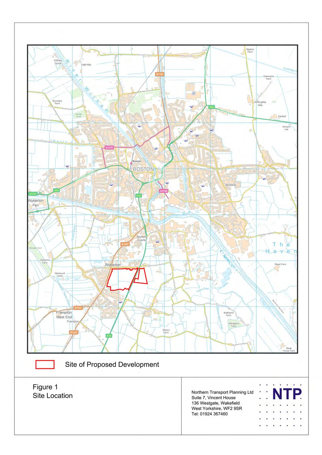
96
97
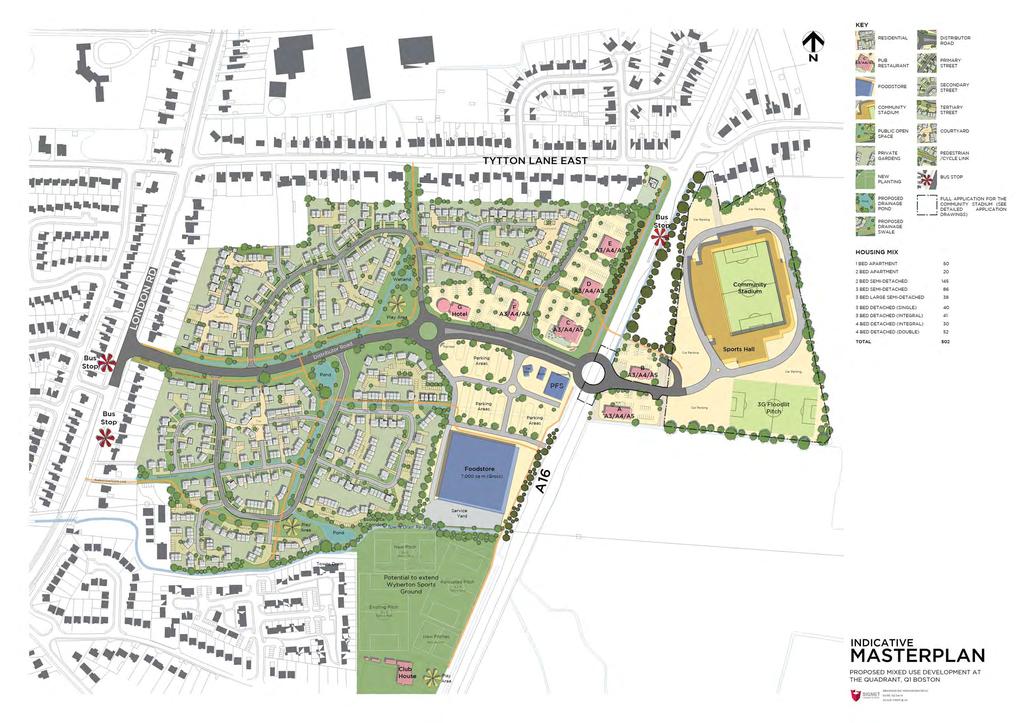
98 Figure
99
100
101
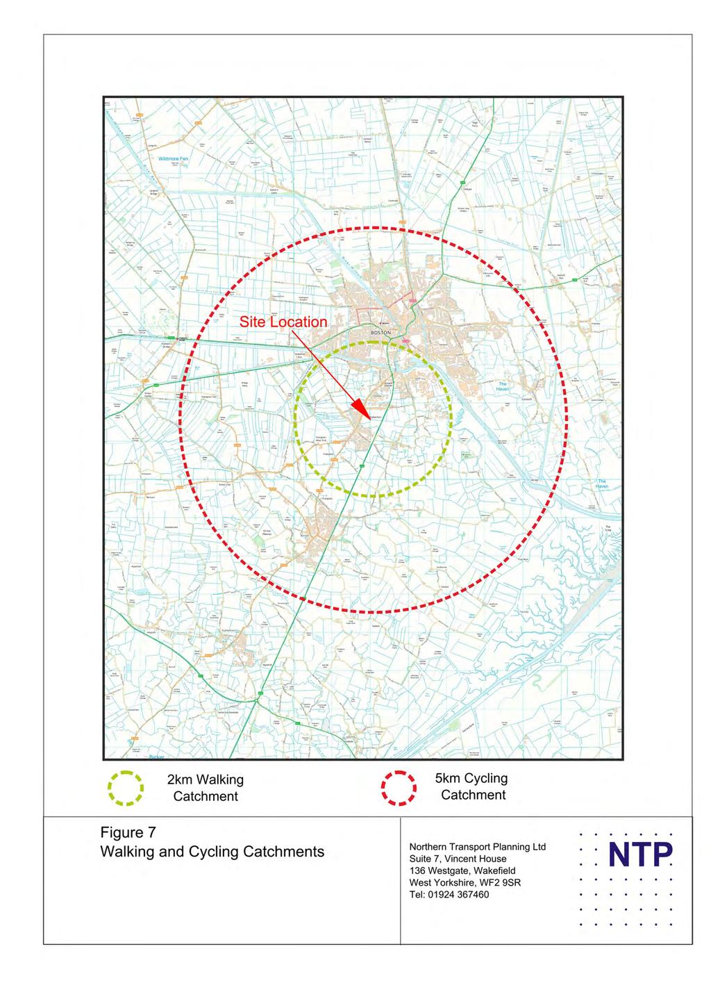
102
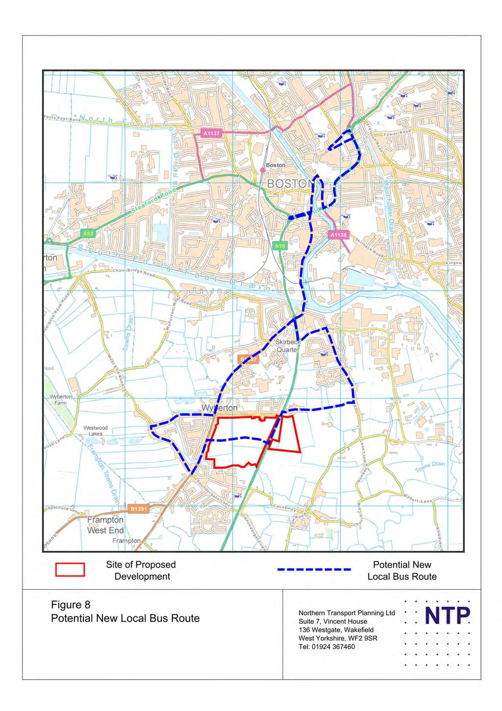
103
104
105 A Liquorpond John Adams Way Spalding Old London B97 London Marsh Lane Tytton Lane West 9 7 Tytton Lane East Tytton Lane East Site of Proposed 88 B97 London Site of Proposed Causeway West End 6 Saundergate Lane B97 London Figure a. Existing Friday Morning Peak Hour Traffic Flows (7484 hours) Northern Transport Planning Ltd Suite 7, Vincent House 6 Westgate WAKEFIELD WF 9SR Tel:
106 A Liquorpond John Adams Way Spalding Old London B97 London Marsh Lane Tytton Lane West 9 Tytton Lane East Tytton Lane East Site of Proposed B97 London Site of Proposed Causeway West End 69 Saundergate Lane B97 London Figure b. Existing Friday Evening Peak Hour Traffic Flows (6474 hours) Northern Transport Planning Ltd Suite 7, Vincent House 6 Westgate WAKEFIELD WF 9SR Tel:
107 A Liquorpond John Adams Way Spalding 4 9 Old London B97 London Marsh Lane Tytton Lane West 6 Tytton Lane East Tytton Lane East Site of Proposed B97 London Site of Proposed Causeway West End 4 Saundergate Lane B97 London Figure c. Existing Saturday Peak Hour Traffic Flows ( hours) Northern Transport Planning Ltd Suite 7, Vincent House 6 Westgate WAKEFIELD WF 9SR Tel:
108 A Liquorpond John Adams Way Spalding Old London B97 London Marsh Lane Tytton Lane West 7 Tytton Lane East Tytton Lane East Site of Proposed B97 London Site of Proposed Causeway 9 6 West End Saundergate Lane B97 London Figure d. Existing Saturday Traffic Flows (4 hours) Northern Transport Planning Ltd Suite 7, Vincent House 6 Westgate WAKEFIELD WF 9SR Tel:
109 A Liquorpond John Adams Way Spalding Old London B97 London Marsh Lane Tytton Lane West Tytton Lane East Tytton Lane East Site of Proposed B97 London Site of Proposed Causeway West End 7 Saundergate Lane B97 London Figure e. Existing Saturday Traffic Flows (78 hours) Northern Transport Planning Ltd Suite 7, Vincent House 6 Westgate WAKEFIELD WF 9SR Tel:
110 Fenside Carlton Castle River Witham Tattershall Robin Hoods Walk Horncastle West Fen Drain Sibsey.%.%.%.%.%.%.%.%.%.% 9.8% 9.8% Langrick.%.% 4.6%.%.% 4.6% Brotherton Carlton Norfolk 4.6%.9%.%.9% 4.6% A Wainfleet Roseberry Avenue.% Tawney.% Wide Bar Gate.%.6%.6%.% ASDA.% A.%.6%.6%.%.%.%.% 4.% West BOSTON TOWN CENTRE Botolph.%.9%.% 4.% 4.%.9% A.%.%.% 4.%.6%.%.%.% 6.% 6.7% 6.7% South Forty.%.%.% 6.% Foot Drain.6% South Woodville Frampton.% Parade Place 6.7% 6.7% Broadfield.% 6.4% 6.6%.% 6.6%.%.4% 6.4%.% Vauxhall Wyberton.%.7% West 9.9%.4%.%.7%.%.%.4% 8.% 4.7% London Skirbeck.4% The Haven West End 9.% 9.% Park.% B97 London.%.%.% 4.9%.4%.4% Marsh Lane 4.9% 4.9% 4.9% 7.4% Tytton Lane West 4.% Tytton Lane East 7.4% Tytton Lane East West End 4.%.% 8.9% Site of Proposed.% 8.9% 8.9% From LR (N).% To (N) B97 London.8% From LR (S).% To (S) To LR (N) 8.9% From (N).% 7.% To LR (S).8% From (S).%.%.8%.8% 7.%.% 4.% Causeway 4.% Saundergate Lane 8.6% 9.% 8.6% 9.% B9.9%.9% B97 London 4.7% 4.7% 4.4% B97 4.4% A7.%.%.% A7.%.%.%.%.7%.%.7% B97 Figure. Distribution of Traffic Generated by the Proposed Residential Northern Transport Planning Ltd Suite 7, Vincent House 6 Westgate WAKEFIELD WF 9SR Tel:
111 Fenside Carlton Castle River Witham Tattershall Robin Hoods Walk Horncastle West Fen Drain Sibsey Langrick Brotherton Carlton Norfolk 4 9 A Wainfleet Roseberry Avenue Tawney Wide Bar Gate ASDA A 8 West BOSTON TOWN CENTRE Botolph A South Forty Foot Drain South Woodville Frampton Parade Place 9 Broadfield 6 6 Vauxhall Wyberton West London Skirbeck 6 The Haven West End 7 7 Park 4 B97 London Marsh Lane Tytton Lane West Tytton Lane East Tytton Lane East West End 7 Site of Proposed 6 4 From LR (N) 6 To (N) B97 London From LR (S) 4 To (S) To LR (N) 4 From (N) To LR (S) From (S) Causeway Saundergate Lane B9 7 B97 London 9 7 B97 A7 A7 B97 Figure a. Traffic Generated by Proposed Residential (Weekday Morning Peak Hour) Northern Transport Planning Ltd Suite 7, Vincent House 6 Westgate WAKEFIELD WF 9SR Tel:
112 Fenside Carlton Castle River Witham Tattershall Robin Hoods Walk Horncastle West Fen Drain Sibsey 6 8 Langrick 6 9 Brotherton Carlton Norfolk 9 7 A Wainfleet Roseberry Avenue Tawney Wide Bar Gate ASDA A West BOSTON TOWN CENTRE Botolph A South Forty 7 Foot Drain South Woodville Frampton Parade Place 9 Broadfield Vauxhall Wyberton 6 West London Skirbeck West End 4 7 B97 London 6 46 Tytton Lane West 7 Park 4 7 Tytton Lane East The Haven Marsh Lane Tytton Lane East West End Site of Proposed 6 4 From LR (N) 6 To (N) B97 London 9 From LR (S) To (S) To LR (N) From (N) 6 To LR (S) 7 From (S) Causeway 7 Saundergate Lane 9 6 B9 7 4 B97 London 9 6 B97 7 A7 A7 B97 Figure b. Traffic Generated by Proposed Residential (Weekday Evening Peak Hour) Northern Transport Planning Ltd Suite 7, Vincent House 6 Westgate WAKEFIELD WF 9SR Tel:
113 Fenside Carlton Castle River Witham Tattershall Robin Hoods Walk Horncastle West Fen Drain Sibsey 4 Langrick 4 Brotherton Carlton Norfolk 6 7 A Wainfleet Roseberry Avenue Tawney Wide Bar Gate ASDA A West BOSTON TOWN CENTRE Botolph A South Forty 7 Foot Drain South Woodville Frampton Parade Place 9 Broadfield Vauxhall Wyberton 4 West London Skirbeck West End B97 London 4 7 Tytton Lane West 9 4 Park Tytton Lane East The Haven Marsh Lane Tytton Lane East West End Site of Proposed 8 4 From LR (N) 8 To (N) B97 London 7 From LR (S) 7 To (S) To LR (N) 4 From (N) 8 To LR (S) 8 From (S) Causeway 4 Saundergate Lane 9 B9 4 B97 London 7 B97 6 A7 A7 B97 Figure c. Traffic Generated by Proposed Residential (Saturday hours) Northern Transport Planning Ltd Suite 7, Vincent House 6 Westgate WAKEFIELD WF 9SR Tel:
114 Fenside Carlton Castle River Witham Tattershall Robin Hoods Walk Horncastle West Fen Drain Sibsey Langrick Brotherton Carlton Norfolk 6 6 A Wainfleet Roseberry Avenue Tawney Wide Bar Gate ASDA A 4 West BOSTON TOWN CENTRE Botolph 4 A South Forty 6 Foot Drain South Woodville Frampton Parade Place 6 8 Broadfield Vauxhall Wyberton West London Skirbeck West End 9 B97 London 4 6 Tytton Lane West Park 4 Tytton Lane East The Haven Marsh Lane Tytton Lane East West End 4 4 Site of Proposed 8 From LR (N) To (N) B97 London 6 From LR (S) To (S) To LR (N) 8 From (N) 4 8 To LR (S) 6 From (S) Causeway 4 Saundergate Lane B9 4 4 B97 London 4 B97 A7 A7 B97 Figure d. Traffic Generated by Proposed Residential (Saturday 4 hours) Northern Transport Planning Ltd Suite 7, Vincent House 6 Westgate WAKEFIELD WF 9SR Tel:
115 Fenside Carlton Castle River Witham Tattershall Robin Hoods Walk Horncastle West Fen Drain Sibsey 4 9 Langrick Brotherton Carlton Norfolk A Wainfleet Roseberry Avenue Tawney Wide Bar Gate ASDA A 4 West BOSTON TOWN CENTRE Botolph 7 A South Forty 6 Foot Drain South Woodville Frampton Parade Place 4 Broadfield Vauxhall Wyberton 4 West London Skirbeck West End 8 B97 London 4 Tytton Lane West Park Tytton Lane East The Haven Marsh Lane Tytton Lane East West End Site of Proposed From LR (N) 9 To (N) B97 London From LR (S) To (S) To LR (N) 6 From (N) 4 9 To LR (S) 4 From (S) Causeway Saundergate Lane B9 4 B97 London 4 6 B97 8 A7 A7 B97 Figure e. Traffic Generated by Proposed Residential (Saturday 78 hours) Northern Transport Planning Ltd Suite 7, Vincent House 6 Westgate WAKEFIELD WF 9SR Tel:
116 Fenside Carlton Castle River Witham Tattershall Robin Hoods Walk Horncastle West Fen Drain Sibsey.7%.%.%.7%.%.% 7.% 7.% Langrick Roseberry Avenue Brothertoft Carlton.7%.7%.7%.7% Norfolk.% Tawney.%.% Wide Bar Gate.%.%.%.% A Wainfleet.%.%.7% ASDA.% A.%.%.7%.%.% 9.7% West BOSTON TOWN CENTRE Botolph 8.% 8.% 8.% 8.%.%.% 9.7%.%.6% 9.7%.%.% South Forty.%.6% 9.7% Foot Drain South Woodville Frampton.6% Parade Place.%.% Broadfield.6%.% 4.8% 4.8% Vauxhall A.% 8.%.% 8.% 4.8%.% 8.% Wyberton.%.% West 8.% 4.8%.%.%.4% 6.4%.%.% 6.4% London Skirbeck.% The Haven West End 7.% 7.% Park.% B97 London.% 4.7% 4.7% 4.7%.%.% Marsh Lane 4.% 4.7% 4.%.% Tytton Lane West.% Tytton Lane East.% Tytton Lane East.% 4.8% 6.% Site of Proposed 4.8% 6.% B97 London West End 9.4%.% 4.8% 4.8% 9.4%.%.% Causeway.% Saundergate Lane.%.%.%.% B9 8.% 8.% B97 London 6.8% 6.8% 9.% B97 9.% A7.%.% 6.% A7.% 6.%.%.%.%.%.% B97 Figure. Distribution of Primary Diverted Shopping Trips Northern Transport Planning Ltd Suite 7, Vincent House 6 Westgate WAKEFIELD WF 9SR Tel:
117 Fenside Carlton Castle River Witham Tattershall Robin Hoods Walk Horncastle West Fen Drain Sibsey Langrick Brotherton Carlton Norfolk A Wainfleet Roseberry Avenue Tawney 4 Wide Bar Gate 4 4 ASDA A 4 West BOSTON TOWN CENTRE Botolph A South Forty 8 Foot Drain South Woodville Frampton Parade Place 9 7 Broadfield Vauxhall Wyberton West London Skirbeck The Haven West End 6 8 Park B97 London Marsh Lane Tytton Lane West 4 Tytton Lane East Tytton Lane East B97 London 7 Site of Proposed 7 Site of Proposed West End Causeway Saundergate Lane 9 PassBy Trips PB in from South PB in from North 8 7 PB out to South 9 B9 7 B97 London 6 PB Out to North London PB in from South PB in from North PB out to South 4 6 PB Out to North 4 B97 Tot PB IN 6 A7 Tot PB OUT 6 6 B A7 Linked Trips Arrivals from Housing Departures to Housing 8 Arrivals from Stad Departures to Stad Figure 4a. Assignment of Traffic Attracted to the Proposed Foodstore (Friday Morning Peak Hour) Northern Transport Planning Ltd Suite 7, Vincent House 6 Westgate WAKEFIELD WF 9SR Tel:
118 Fenside Carlton Castle River Witham Tattershall Robin Hoods Walk Horncastle West Fen Drain Sibsey Langrick Brotherton Carlton Norfolk A Wainfleet Roseberry Avenue 6 Tawney 6 Wide Bar Gate 6 6 ASDA 6 A West BOSTON TOWN CENTRE Botolph 7 6 A South Forty 4 Foot Drain 9 South Woodville Frampton Parade Place 47 4 Broadfield Vauxhall Wyberton 4 West London Skirbeck 4 The Haven West End 4 Park 4 B97 London Marsh Lane Tytton Lane West 4 Tytton Lane East 4 Tytton Lane East 4 84 Site of Proposed 88 B97 London Site of Proposed West End Causeway 4 Saundergate Lane PassBy Trips PB in from South PB in from North PB out to South B9 6 7 B97 London 4 PB Out to North London PB in from South PB in from North PB out to South 8 9 PB Out to North 8 B97 7 Tot PB IN A7 4 Tot PB OUT 7 4 A7 B97 Linked Trips Arrivals from Housing Departures to Housing Arrivals from Stad Departures to Stad Figure 4b. Assignment of Traffic Attracted to the Proposed Foodstore (Friday Evening Peak Hour) Northern Transport Planning Ltd Suite 7, Vincent House 6 Westgate WAKEFIELD WF 9SR Tel:
119 Fenside Carlton Castle River Witham Tattershall Robin Hoods Walk Horncastle West Fen Drain Sibsey Langrick 8 8 Norfolk Brotherton Carlton A Wainfleet Roseberry Avenue 7 Tawney Wide Bar Gate ASDA A West 8 4 BOSTON TOWN CENTRE Botolph A South Forty 6 Foot Drain South Woodville Frampton 6 Parade Place 8 Broadfield Vauxhall Wyberton West London Skirbeck The Haven West End 6 8 Park B97 London 94 Marsh Lane 94 9 Tytton Lane West Tytton Lane East Tytton Lane East 9 6 Site of Proposed 99 4 B97 London Site of Proposed West End Causeway Saundergate Lane PassBy Trips PB in from South 6 PB in from North PB out to South PB Out to North 4 4 B9 9 B97 London London PB in from South PB in from North 7 44 PB out to South PB Out to North B97 48 Tot PB IN Tot PB OUT 78 7 A7 4 A7 4 8 B97 Linked Trips Arrivals from Housing Departures to Housing Arrivals from Stad Departures to Stad 4 Figure 4c. Assignment of Traffic Attracted to the Proposed Foodstore (Saturday hours) Northern Transport Planning Ltd Suite 7, Vincent House 6 Westgate WAKEFIELD WF 9SR Tel:
120 Fenside Carlton Castle River Witham Tattershall Robin Hoods Walk Horncastle West Fen Drain Sibsey Langrick Brotherton Carlton Norfolk A Wainfleet Roseberry Avenue 7 Tawney Wide Bar Gate ASDA 7 A West BOSTON TOWN CENTRE Botolph 4 4 A South Forty 4 Foot Drain 9 South Woodville Frampton Parade Place 4 4 Broadfield Vauxhall Wyberton 4 West London Skirbeck The Haven West End 7 Park B97 London Marsh Lane 8 97 Tytton Lane West 4 Tytton Lane East 4 Tytton Lane East 8 Site of Proposed B97 London Site of Proposed West End Causeway Saundergate Lane 4 PassBy Trips PB in from South PB in from North PB out to South PB Out to North 4 4 B9 6 B97 London 6 London PB in from South PB in from North 4 PB out to South PB Out to North B97 6 Tot PB IN Tot PB OUT 7 7 A Linked Trips Arrivals from Housing B97 A7 Departures to Housing Arrivals from Stad Departures to Stad Figure 4d. Assignment of Traffic Attracted to the Proposed Foodstore (Saturday 4 hours) Northern Transport Planning Ltd Suite 7, Vincent House 6 Westgate WAKEFIELD WF 9SR Tel:
121 Fenside Carlton Castle River Witham Tattershall Robin Hoods Walk Horncastle West Fen Drain Sibsey Langrick Brotherton Carlton Norfolk A Wainfleet Roseberry Avenue 6 Tawney 6 Wide Bar Gate 6 6 ASDA 6 A West BOSTON TOWN CENTRE Botolph 4 6 A South Forty 4 8 Foot Drain 9 South Woodville Frampton Parade Place 4 4 Broadfield Vauxhall Wyberton 4 West London Skirbeck 4 The Haven West End 4 Park 4 B97 London Marsh Lane Tytton Lane West 4 Tytton Lane East 4 Tytton Lane East 4 8 Site of Proposed 8 B97 London Site of Proposed West End Causeway Saundergate Lane 4 PassBy Trips PB in from South 8 4 PB in from North 4 PB out to South PB Out to North 4 4 B9 6 6 B97 London London PB in from South PB in from North 6 PB out to South PB Out to North B97 8 Tot PB IN Tot PB OUT 6 7 A7 4 4 A7 B97 Linked Trips Arrivals from Housing Departures to Housing Arrivals from Stad Departures to Stad 9 Figure 4e. Assignment of Traffic Attracted to the Proposed Foodstore (Saturday 78 hours) Northern Transport Planning Ltd Suite 7, Vincent House 6 Westgate WAKEFIELD WF 9SR Tel:
122 Fenside Carlton Castle River Witham Tattershall Robin Hoods Walk Horncastle West Fen Drain Sibsey Langrick 4 Roseberry Avenue Brotherton Carlton 4 Norfolk Tawney Wide Bar Gate A Wainfleet 4 ASDA A West BOSTON TOWN CENTRE Botolph A South Forty Foot Drain South Woodville Frampton Parade Place 8 Broadfield Vauxhall Wyberton 6 West London Skirbeck The Haven West End 9 Park 8 B97 London 6 6 Marsh Lane 8 4 Tytton Lane West Tytton Lane East Tytton Lane East 9 4 Site of Proposed B97 London Site of Proposed West End Causeway 9 Saundergate Lane 8 4 B9 7 B97 London B97 A7 A7 B97 Figure a. Redistribution of Primary Shopping Trips Net Difference in Shopping Traffic Flows (Morning Peak Hour) Northern Transport Planning Ltd Suite 7, Vincent House 6 Westgate WAKEFIELD WF 9SR Tel:
123 Fenside Carlton Castle River Witham Tattershall Robin Hoods Walk Horncastle West Fen Drain Sibsey 4 Langrick Norfolk Brotherton Carlton Roseberry Avenue 7 Tawney 4 Wide Bar Gate A Wainfleet 9 ASDA A West BOSTON TOWN CENTRE Botolph A 7 South Forty 47 Foot Drain South Woodville Frampton Parade Place Broadfield Vauxhall Wyberton 6 6 West London Skirbeck The Haven West End Park B97 London 48 Marsh Lane 6 4 Tytton Lane West Tytton Lane East Tytton Lane East 6 Site of Proposed 6 6 B97 London Site of Proposed West End Causeway Saundergate Lane B9 B97 London 6 B97 A7 6 6 A7 B97 Figure b. Redistribution of Primary Shopping Trips Net Difference in Shopping Traffic Flows (Evening Peak Hour) Northern Transport Planning Ltd Suite 7, Vincent House 6 Westgate WAKEFIELD WF 9SR Tel:
124 Fenside Carlton Castle River Witham Tattershall Robin Hoods Walk Horncastle West Fen Drain Sibsey Langrick Norfolk Brotherton Carlton 4 Roseberry Avenue 8 Tawney 4 Wide Bar Gate A Wainfleet 6 66 ASDA A West BOSTON TOWN CENTRE Botolph 4 9 A South Forty 64 Foot Drain South Woodville Frampton Parade Place 6 Broadfield Vauxhall Wyberton 69 7 West London Skirbeck The Haven West End Park 7 B97 London Marsh Lane Tytton Lane West Tytton Lane East Tytton Lane East 77 Site of Proposed 64 B97 London Site of Proposed West End Causeway 9 Saundergate Lane 7 8 B9 4 B97 London B97 7 A A7 B97 Figure c. Redistribution of Primary Shopping Trips Net Difference in Shopping Traffic Flows (Saturday hours) Northern Transport Planning Ltd Suite 7, Vincent House 6 Westgate WAKEFIELD WF 9SR Tel:
125 Fenside Carlton Castle River Witham Tattershall Robin Hoods Walk Horncastle West Fen Drain Sibsey Langrick Norfolk Brotherton Carlton 6 Roseberry Avenue 8 6 Tawney 6 Wide Bar Gate A Wainfleet 4 69 ASDA A West BOSTON TOWN CENTRE Botolph 6 A South Forty 4 Foot Drain South Woodville Frampton Parade Place 9 Broadfield Vauxhall Wyberton 7 7 West 7 4 London Skirbeck The Haven West End 6 6 Park B97 London Marsh Lane 7 7 Tytton Lane West Tytton Lane East Tytton Lane East 47 Site of Proposed 76 4 B97 London Site of Proposed West End Causeway 4 Saundergate Lane B9 B97 London 6 6 B97 A7 7 A7 B97 Figure d. Redistribution of Primary Shopping Trips Net Difference in Shopping Traffic Flows (Saturday 4 hours) Northern Transport Planning Ltd Suite 7, Vincent House 6 Westgate WAKEFIELD WF 9SR Tel:
126 Fenside Carlton Castle River Witham Tattershall Robin Hoods Walk Horncastle West Fen Drain Sibsey 4 Langrick Norfolk Brotherton Carlton 4 Roseberry Avenue 7 4 Tawney 4 Wide Bar Gate A Wainfleet 4 ASDA A West BOSTON TOWN CENTRE Botolph A South Forty 49 Foot Drain South Woodville Frampton Parade Place 9 Broadfield Vauxhall Wyberton 6 6 West London Skirbeck The Haven West End 9 Park B97 London 46 4 Marsh Lane 4 49 Tytton Lane West Tytton Lane East Tytton Lane East 9 Site of Proposed B97 London Site of Proposed West End 7 4 Causeway Saundergate Lane B9 B97 London B97 A7 6 A7 B97 Figure e. Redistribution of Primary Shopping Trips Net Difference in Shopping Traffic Flows (Saturday 78 hours) Northern Transport Planning Ltd Suite 7, Vincent House 6 Westgate WAKEFIELD WF 9SR Tel:
127 Fenside Carlton Castle River Witham Tattershall Robin Hoods Walk Horncastle West Fen Drain Sibsey Langrick Norfolk Brotherton Carlton A Wainfleet Roseberry Avenue Tawney Wide Bar Gate ASDA A 4 West BOSTON TOWN CENTRE Botolph A South Forty 4 Foot Drain South Woodville Frampton Parade Place 9 9 Broadfield Vauxhall Wyberton West 7 6 London Skirbeck West End Park B97 London The Haven Marsh Lane Tytton Lane West Tytton Lane East Tytton Lane East West End 8 Site of Proposed 8 B97 London 4 4 Site of Proposed Causeway Saundergate Lane B9 B97 London 8 B97 8 A7 PassBy Trips PB in from South 4 PB in from North PB out to South 4 A7 PB Out to North B97 Figure 6a. Assignment of Traffic Attracted to the Stadium Complex (Weekday Morning Peak Hour) Northern Transport Planning Ltd Suite 7, Vincent House 6 Westgate WAKEFIELD WF 9SR Tel:
128 Fenside Carlton Castle River Witham Tattershall Robin Hoods Walk Horncastle West Fen Drain Sibsey Langrick Norfolk Brotherton Carlton A Wainfleet Roseberry Avenue Tawney Wide Bar Gate ASDA A 4 West BOSTON TOWN CENTRE Botolph A South Forty 4 Foot Drain South Woodville Frampton Parade Place 9 9 Broadfield Vauxhall Wyberton West 7 6 London Skirbeck West End Park B97 London The Haven Marsh Lane Tytton Lane West Tytton Lane East Tytton Lane East West End 8 Site of Proposed 8 B97 London 4 4 Site of Proposed Causeway Saundergate Lane B9 B97 London 8 B97 8 A7 PassBy Trips PB in from South PB in from North 4 PB out to South A7 PB Out to North 4 B97 Figure 6b. Assignment of Traffic Attracted to the Stadium Complex (Weekday Evening Peak Hour) Northern Transport Planning Ltd Suite 7, Vincent House 6 Westgate WAKEFIELD WF 9SR Tel:
129 Fenside Carlton Castle River Witham Tattershall Robin Hoods Walk Horncastle West Fen Drain Sibsey Langrick Norfolk Brotherton Carlton A Wainfleet Roseberry Avenue Tawney Wide Bar Gate ASDA A 4 West BOSTON TOWN CENTRE Botolph A South Forty 4 Foot Drain South Woodville Frampton Parade Place 9 9 Broadfield Vauxhall Wyberton West 7 6 London Skirbeck West End Park B97 London The Haven Marsh Lane Tytton Lane West Tytton Lane East Tytton Lane East West End 8 Site of Proposed 8 B97 London 4 4 Site of Proposed Causeway Saundergate Lane B9 B97 London 8 B97 8 A7 PassBy Trips PB in from South PB in from North 4 PB out to South A7 PB Out to North 4 B97 Figure 6c. Assignment of Traffic Attracted to the Stadium Complex (Saturday hours) Northern Transport Planning Ltd Suite 7, Vincent House 6 Westgate WAKEFIELD WF 9SR Tel:
130 Fenside Carlton Castle River Witham Tattershall Robin Hoods Walk Horncastle West Fen Drain Sibsey 4 Langrick Norfolk Brotherton Carlton 4 A Wainfleet Roseberry Avenue Tawney 4 Wide Bar Gate 4 4 ASDA A West BOSTON TOWN CENTRE Botolph 8 8 A 4 South Forty 9 Foot Drain South Woodville Frampton Parade Place 4 Broadfield Vauxhall Wyberton 9 West London Skirbeck West End Park B97 London 9 69 The Haven Marsh Lane Tytton Lane West 9 Tytton Lane East 9 Tytton Lane East West End 4 78 Site of Proposed 4 B97 London 4 Site of Proposed Causeway 9 Saundergate Lane 68 B9 8 B97 London B97 87 A7 9 7 A7 4 B97 Figure 6d. Assignment of Traffic Attracted to the Stadium Complex (Net Change Saturday Match Day 4 hours) Northern Transport Planning Ltd Suite 7, Vincent House 6 Westgate WAKEFIELD WF 9SR Tel:

131 Fenside Carlton Castle River Witham Tattershall Robin Hoods Walk Horncastle West Fen Drain Sibsey 4 Langrick Norfolk Brotherton Carlton A Wainfleet Roseberry Avenue 4 Tawney Wide Bar Gate ASDA 4 A 4 4 West BOSTON TOWN CENTRE Botolph 8 8 A South Forty Foot Drain South Woodville Frampton Parade Place 4 6 Broadfield Vauxhall Wyberton West London Skirbeck West End B97 London Tytton Lane West 7 9 Park 6 Tytton Lane East 9 The Haven Marsh Lane Tytton Lane East West End 9 Site of Proposed 4 8 B97 London 4 4 Site of Proposed 9 Causeway Saundergate Lane 68 B9 8 B97 London 87 B97 A A7 B97 Figure 6e. Assignment of Traffic Attracted to the Stadium Complex (Net Change Saturday Match Day 78 hours) Northern Transport Planning Ltd Suite 7, Vincent House 6 Westgate WAKEFIELD WF 9SR Tel:
132 Fenside Carlton Castle River Witham Tattershall Robin Hoods Walk Horncastle West Fen Drain Sibsey Langrick Norfolk Brotherton Carlton A Wainfleet Roseberry Avenue Tawney Wide Bar Gate ASDA Botolph 6 A West BOSTON TOWN CENTRE 6 A 6 8 South Forty Foot Drain South Woodville Frampton Parade Place 8 6 Broadfield Vauxhall Wyberton West 4 7 London Skirbeck The Haven West End Park B97 London Marsh Lane Tytton Lane West Tytton Lane East Tytton Lane East Site of Proposed 4 B97 London Site of Proposed West End Causeway Saundergate Lane B9 B97 London 6 B97 A7 A7 4 B97 Figure 7a. Traffic Movements Attracted to the Proposed Food and Drink Units and Hotel (Primary Trips Morning Peak Hour) Northern Transport Planning Ltd Suite 7, Vincent House 6 Westgate WAKEFIELD WF 9SR Tel:
133 Fenside Carlton Castle River Witham Tattershall Robin Hoods Walk Horncastle West Fen Drain Sibsey 4 Langrick Norfolk Brotherton Carlton A Wainfleet Roseberry Avenue Tawney Wide Bar Gate ASDA Botolph 9 A 6 West BOSTON TOWN CENTRE 9 A 6 6 South Forty Foot Drain South Woodville Frampton Parade Place 6 Broadfield Vauxhall Wyberton West 8 9 London Skirbeck The Haven West End 4 Park B97 London 8 8 Marsh Lane Tytton Lane West Tytton Lane East Tytton Lane East 9 4 Site of Proposed B97 London Site of Proposed West End Causeway Saundergate Lane 8 B9 6 4 B97 London 4 B97 A7 A B97 Figure 7b. Traffic Movements Attracted to the Proposed Food and Drink Units and Hotel (Primary Trips Evening Peak Hour) Northern Transport Planning Ltd Suite 7, Vincent House 6 Westgate WAKEFIELD WF 9SR Tel:
134 Fenside Carlton Castle River Witham Tattershall Robin Hoods Walk Horncastle West Fen Drain Sibsey 4 Langrick Norfolk Brotherton Carlton A Wainfleet Roseberry Avenue Tawney Wide Bar Gate ASDA Botolph 7 A West BOSTON TOWN CENTRE 7 A 4 9 South Forty 4 Foot Drain South Woodville Frampton Parade Place 9 Broadfield 6 Vauxhall Wyberton West London Skirbeck The Haven West End 4 Park B97 London 7 Marsh Lane 7 Tytton Lane West Tytton Lane East Tytton Lane East Site of Proposed 8 B97 London Site of Proposed West End 4 Causeway Saundergate Lane B9 4 B97 London 4 8 B97 A7 A7 6 B97 Figure 7c. Traffic Movements Attracted to the Proposed Food and Drink Units and Hotel (Primary Trips Saturday hours) Northern Transport Planning Ltd Suite 7, Vincent House 6 Westgate WAKEFIELD WF 9SR Tel:
135 Fenside Carlton Castle River Witham Tattershall Robin Hoods Walk Horncastle West Fen Drain Sibsey 6 Langrick Norfolk Brotherton Carlton A Wainfleet Roseberry Avenue Tawney Wide Bar Gate ASDA Botolph A West BOSTON TOWN CENTRE A South Forty 8 Foot Drain South Woodville Frampton Parade Place 9 Broadfield 4 4 Vauxhall Wyberton West 4 4 London Skirbeck The Haven West End 6 Park B97 London 4 Marsh Lane 4 Tytton Lane West Tytton Lane East Tytton Lane East Site of Proposed 6 B97 London Site of Proposed West End 8 Causeway Saundergate Lane 9 B9 7 B97 London 6 6 B97 A7 A7 9 B97 Figure 7d. Traffic Movement Attracted to the Proposed Food and Drink Units and Hotel (Primary Trips Saturday 4 hours) Northern Transport Planning Ltd Suite 7, Vincent House 6 Westgate WAKEFIELD WF 9SR Tel:

136 Fenside Carlton Castle River Witham Tattershall Robin Hoods Walk Horncastle West Fen Drain Sibsey 7 Langrick Norfolk Brotherton Carlton A Wainfleet Roseberry Avenue Tawney Wide Bar Gate ASDA Botolph 8 A 9 West BOSTON TOWN CENTRE 8 A 9 South Forty Foot Drain South Woodville Frampton Parade Place Broadfield 7 Vauxhall Wyberton West 4 6 London Skirbeck The Haven West End 7 Park B97 London 4 4 Marsh Lane 4 Tytton Lane West Tytton Lane East Tytton Lane East 4 6 Site of Proposed B97 London Site of Proposed West End Causeway Saundergate Lane B9 8 B97 London 7 B97 9 A7 A7 6 B97 Figure 7e. Traffic Movement Attracted to the Proposed Food and Drink Units and Hotel (Primary Trips Saturday 78 hours) Northern Transport Planning Ltd Suite 7, Vincent House 6 Westgate WAKEFIELD WF 9SR Tel:
137 A Liquorpond John Adams Way Spalding Old London B97 London Marsh Lane Tytton Lane West 6 98 Tytton Lane East Tytton Lane East Site of Proposed B97 London Site of Proposed Causeway West End 8 Saundergate Lane B97 London Figure 8a. Morning Peak Hour Traffic Flows Without Northern Transport Planning Ltd Suite 7, Vincent House 6 Westgate WAKEFIELD WF 9SR Tel:
138 A Liquorpond John Adams Way Spalding Old London B97 London Marsh Lane Tytton Lane West Tytton Lane East Tytton Lane East Site of Proposed B97 London Site of Proposed Causeway West End 8 Saundergate Lane B97 London Figure 8b. Evening Peak Hour Traffic Flows Without Northern Transport Planning Ltd Suite 7, Vincent House 6 Westgate WAKEFIELD WF 9SR Tel:
139 A Liquorpond John Adams Way Spalding Old London B97 London Marsh Lane Tytton Lane West Tytton Lane East Tytton Lane East Site of Proposed B97 London Site of Proposed Causeway West End 6 Saundergate Lane B97 London Figure 8c. Saturday Peak Hour Traffic Flows Without Northern Transport Planning Ltd Suite 7, Vincent House 6 Westgate WAKEFIELD WF 9SR Tel:
140 A Liquorpond John Adams Way Spalding Old London B97 London Marsh Lane Tytton Lane West Tytton Lane East Tytton Lane East Site of Proposed B97 London Site of Proposed Causeway West End Saundergate Lane B97 London Figure 8d. Saturday Traffic Flows (4 hours) Without Northern Transport Planning Ltd Suite 7, Vincent House 6 Westgate WAKEFIELD WF 9SR Tel:
141 A Liquorpond John Adams Way Spalding Old London B97 London Marsh Lane Tytton Lane West 76 Tytton Lane East Tytton Lane East Site of Proposed B97 London Site of Proposed Causeway 9 6 West End 6 Saundergate Lane B97 London Figure 8e. Saturday Traffic Flows (78 hours) Without Northern Transport Planning Ltd Suite 7, Vincent House 6 Westgate WAKEFIELD WF 9SR Tel:
142 A Liquorpond John Adams Way Spalding Old London B97 London Marsh Lane Tytton Lane West Tytton Lane East Tytton Lane East Site of Proposed B97 London Site of Proposed Causeway West End 8 Saundergate Lane B97 London Figure 9a. Morning Peak Hour Traffic Flows With Northern Transport Planning Ltd Suite 7, Vincent House 6 Westgate WAKEFIELD WF 9SR Tel:
143 A Liquorpond John Adams Way Spalding Old London B97 London Marsh Lane Tytton Lane West Tytton Lane East Tytton Lane East Site of Proposed B97 London Site of Proposed Causeway West End 464 Saundergate Lane B97 London Figure 9b. Evening Peak Hour Traffic Flows With Northern Transport Planning Ltd Suite 7, Vincent House 6 Westgate WAKEFIELD WF 9SR Tel:
144 A Liquorpond John Adams Way Spalding Old London B97 London Marsh Lane Tytton Lane West 7 7 Tytton Lane East Tytton Lane East Site of Proposed B97 London Site of Proposed Causeway West End 7 Saundergate Lane B97 London Figure 9c. Saturday Traffic Flows With ( hours) Northern Transport Planning Ltd Suite 7, Vincent House 6 Westgate WAKEFIELD WF 9SR Tel:
145 A Liquorpond John Adams Way Spalding Old London B97 London 89 7 Marsh Lane Tytton Lane West Tytton Lane East Tytton Lane East Site of Proposed B97 London Site of Proposed Causeway West End 7 Saundergate Lane B97 London Figure 9d. Saturday Traffic Flows With (4 hours) Northern Transport Planning Ltd Suite 7, Vincent House 6 Westgate WAKEFIELD WF 9SR Tel:
146 A Liquorpond John Adams Way Spalding Old London B97 London Marsh Lane Tytton Lane West 67 9 Tytton Lane East Tytton Lane East Site of Proposed B97 London Site of Proposed Causeway West End Saundergate Lane B97 London Figure 9e. Saturday Traffic Flows With (7 8 hours Northern Transport Planning Ltd Suite 7, Vincent House 6 Westgate WAKEFIELD WF 9SR Tel:
147 Appendix A
148
149 Appendix B
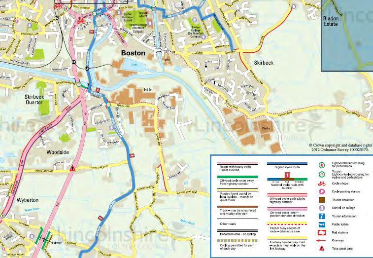
150
151 Appendix C
 and Stagecoach (SCL)")
152 Lincoln Woodhall Spa Boston InterConnect Monday to Saturday except Bank Holidays Skegness Wainfleet Boston Operated by Brylaine Travel NS NS S* Sch NS Monday to Saturday only Operator code Lincoln City Bus Station Metheringham Coop InterConnect 7 Skegness Bus Station INTERCONNECT DAYS OUT Operated by Brylaine Travel (BRY) and Stagecoach (SCL) SCL SCL SCL SCL BRY 6 7 S* Sch Sch 8 8 SCL BRY SCL BRY 9 9 SCL SCL BRY BRY SCL Wainfleet Market Place Friskney Barley Mow PH Tattershall Market Place Wrangle Tooley Lane Coningsby Interchange Wrangle Angel Inn Gipsey Bridge Old Leake Church End Langrick Leverton Fire Station Antons Gowt Benington Nelson Inn Pilgrim Hospital Butterwick Five Bells PH Boston Bus Station Freiston Church until then every minutes at Martin Church Corner Woodhall Spa IN LINCOLNSHIRE MAKING A CONNECTION Lincolnshire s award winning InterConnect Bus Service Network. Connecting people to places. InterConnect is a quality network of connecting local bus services designed to improve transport links to destinations throughout Lincolnshire and beyond, making travel by bus easier, quicker and more efficient. BUS STOP Boston Woodhall Spa Lincoln InterConnect Monday to Saturday except Bank Holidays Boston Wainfleet Skegness Operated by Brylaine Travel S* Sch NS NS InterConnect 7 NS Boston Bus Station Monday to Saturday only Boston Market Place Operator code Operated by Brylaine Travel (BRY) and Stagecoach (SCL) SCL SCL BRY SCL BRY SCL BRY SCL BRY BRY S* Sch BRY SCL SCL SCL SCL A Boston Bus Station Langrick Boston Pilgrim Hospital Gipsey Bridge Freiston Church Coningsby Interchange Butterwick Five Bells PH Tattershall Market Place Benington Nelson Inn Woodhall Spa Leverton Fire Station Martin Church Corner Old Leake Church End Metheringham Coop Wrangle Angel Inn Wrangle Tooley Lane Code: Sch Schooldays only S* Saturday & School Holidays NS Not Saturdays until then every minutes at Pilgrim Hospital Antons Gowt Lincoln City Bus Station Friskney Church Wainfleet Market Place Skegness Bus Station BUS STOP Operates with financial support from Lincolnshire County Council Code: A Operates via Boston FE College at 7 CD Terminates at Boston College S* Saturday & College Holidays only Sch School days only Issue 8 May BUS GUIDE BOSTON AREA Service operated by easy access low floor vehicles, subject to availability 6 to Horncastle West Fen Drain Green Lane CONTACTING THE COUNTY COUNCIL Horncastle W ith am 6 Robin Hood s Walk ASDA Boston Railway Line and station Parkside Surgery Market Place Hospital 6 terminating services: 4 6 CallConnect service operates in this area Please call to book 6 Oldrids 6 Please recycle this leaflet STREET W EST Bus Station South Parade 6 Hessle Avenue terminating services: Y J OHN Broadfield Lane Liquorpond Surgery High Welland Hessle Drive Thornton Avenue Staniland Wellington H STRE E T UT Sleaford SO H I GH STREET Fitness First West Westside Surgery John Adams Way W AY ADAMS South End Wellington Boston College Ward Crescent Skirbeck Church Green Kingsway eh av en 6 6 Rider Gardens Public Transport Information in Lincolnshire IN LINCOLNSHIRE Boston Tourist Information Centre 66 6 PUBLIC TRANSPORT INFORMATION FOR LINCOLNSHIRE Log on to lincsbus to find out more about: Bus Timetables Bus Service Routes News Visitor Information Woad Farm Th 8 to Kirton to Spalding Woodthorpe Fishtoft Lincolnshire County Council Whilst every effort has been made to ensure accuracy of this document, Lincolnshire County Council cannot be held responsible for any errors or changes in the information given. Church Green London Traveline DAYS OUT 6 6 Eastwood White House Lane Fishtoft Produced by Lincolnshire County Council Customer Service Centre Numbers School Transport 78 Public Transport Team 78 7 National Express Lindis Wide Bargate Lincolnshire County Council National Rail Enquiries (Local Rate) Start of Lincolnshire Walks Princess Anne USEFUL INFORMATION Boston Pilgrim Hospital 6 48 Tourist Information terminating services: 6 For further information please visit Boston Borough Council 4 Direction of route 6 to Billingborough and Folkingham 44 to Lincoln 9 to Spalding CallConnect Filler Occasional service Tollfield Spilsby Wide Bargate Interchange 4 Fenside FOR FURTHER DETAILS Combined services Tawney Fydell IN THIS AREA CALL Other bus services 7 to Skegness to Alford 4 4 Tattershall 6 Horncastle Y4 IN LINCOLNSHIRE OPERATES Boston Into Town service Carlton This publication can be made available on request in alternative formats and languages. Please telephone 78 6 for details. Sibsey Wainfleet General Enquiries 78 7 Or visit our website: Pilgrim Hospital CALLCONNECT DAYS OUT Boston Town Map 4 Shaw us at transportation_group@lincolnshire.gov.uk to Lincoln 8 to Alford and Mablethorpe to Spilsby Y4 to Toynton All Saints r ve Ri Lincolnshire County Council Communities Directorate Transportation Group City Hall Lincoln LN DN Whilst every effort has been made to ensure the accuracy of this publication, Lincolnshire County Council cannot be held responsible for any errors or changes in the information given. Boston Pilgrim Hospital Boston Bus Station OPERATOR DETAILS Brylaine Grayscroft Coaches Haines Coaches 7 9 Hunts Coaches Kimes Buses Stagecoach

153 Horncastle Boston Brylaine 6 Boston Donington Spalding Kimes 9 Boston Spalding Brylaine Monday to Saturday except Bank Holidays Boston Kirton Monday to Saturday NS NS S Sch H H H H H H H H Sch Boston Bus Station Boston Market Place Newtons Corner Parthian Avenue 8# Mill Hill Lighton Avenue Horseshoe Lane Kirton Memorial Kirton (Middlecott) 84 Kirton Boston NS S ScH NS Boston Bus Station Boston Market Place Rawsons Lane 4 4 Cowbridge Frithville Bdge Carrington School New Bollingbroke Royal Oak Revesby Red Lion Mareham Le Fen Royal Oak Wood Enderby Scrivelsby Lion Gate Horncastle Market Place Horncastle Market Place 94 Thornton 9 Roughton 9 Woodhall Spa Hotel Tattershall Market Place 4 Coningsby Community Centre 4 Kirkby on Bain 6 4 Roughton 8 4 Horncastle Market Place 4 8 Horncastle Market Place Scrivelsby Lion Gate Wood Enderby Mareham Le Fen Royal Oak Revesby Red Lion Inn Revesby/Greens Builders New Bolingbroke Royal Oak Carrington School Frithville Cowbridge Rawsons Lane 9 44 John Adams Way 44 Boston Post Office 86 Boston Bus Station Code: S Saturdays & School Holidays Sch Schooldays only NS Not Saturdays Kimes 8 Kimes 8 Monday to Saturday NS S Sch S Kirton (Middlecott) Kirton Memorial Mill Hill Parthian Avenue # Newtons Corner Boston Market Place 8 Boston Bus Station Code: NS Not Saturdays Sch Schooldays only S Saturdays Only H Via Hardwick Estate # Via Main Monday to Friday A Sch SH Sch C NS Boston Schools B D Boston Bus Station M 8 Wyberton Chain Bridge Hubberts Bridge Kirton Holme Swineshead Church Bicker 7R R 68 6R 7 77R 87 Donington Mkt Place Quadring Gosberton Pinchbeck Cemetery 7P P Spalding New Hospital Spalding Bus Station Code: A A only (Not Swineshead Village) C College Day Only B Boston High School D John Adams Way M via Boston Market Place P Pinchbeck Church R Red Lion Public House Sch Schooldays Only Spalding Donington Boston Monday to Friday Sch Sch* A Spalding Bus Station Spalding New Hospital Pinchbeck Cemetery 76P Gosberton Quadring Donington Mkt Place A Bicker 7 7R 7 7R Swineshead Church Kirton Holme Hubberts Bridge Wyberton Chain Bridge Boston Bus Station Boston Schools 8B Code: A A only (Not Swineshead Village) B Boston High School P Pinchbeck Church R Red Lion public House Sch Schooldays Only Sch* School & College Days Boston Donington Spalding Saturday Boston Bus Station Wyberton Chain Bridge Hubberts Bridge Kirton Holme Swineshead Church Bicker Donington Mkt Place Gosberton Surfleet Pinchbeck Cemetery Spalding New Hospital Spalding Bus Station Boston Fishtoft Kimes 9 Kimes 9 Spalding Donington Boston Kimes 9 Brylaine 6 Monday to Saturday except Bank Holidays ^ Sch S* Boston Market Place Frieston / Richmond Close Eastwood Post Office Hawthorn Tree Corner Bladon Estate Fishtoft/ Scotia Rider Gardens Boston/ Fishtoft Boston Market Place Asda Sleaford / The Minstrels 9 4 Welland Sleaford / Roseberry Avenue 4 6 Asda 4 6 Boston Market Place ^ Code: ^ Between these points the timetable reads from bottom to top Sch Schooldays Only S* Saturdays and schooldays only Saturday Spalding Bus Station Spalding New Hospital Pinchbeck Cemetery Surfleet Gosberton Donington Mkt Place Bicker Swineshead Church Kirton Holme Hubberts Bridge Wyberton Chain Bridge Boston Bus Station Monday to Saturday except Bank Holidays NS C NS NS Boston Bus Station Boston Market Place Wyberton Pin Kirton Memorial Sutterton Crossroads Gosberton Bell Surfleet Church Pinchbeck Bull Spalding Bus Station Spalding Boston Boston Spilsby Spilsby Boston WHAT BUS DO I USE FOR Brylaine Monday to Saturday excluding Bank Holidays A Sch SSH Sch/A Boston Bus Station Boston Mkt Place Pilgrim Hospital Sibsey Post Office Sibsey Northlands Stickney Stickford West Keal East Keal Spilsby Mkt Place Brylaine Monday to Saturday excluding Bank Holidays Sch SSH Sch Spilsby Mkt Place C 6 East Keal West Keal Stickford Stickney Sibsey Northlands Sibsey Post Office Pilgrim Hospital Boston Bus Station Code: Sch Schooldays SSH Saturdays and school holiday A Calls at Spilsby High School at 8 and C Departure point is Spilsby High School Then every mins at until Brylaine Monday to Saturday except Bank Holidays B NS NS SH C Spalding Bus Station Pinchbeck Bull Surfleet Church Gosberton Bell Sutterton Crossroads Kirton Memorial Wyberton Pin Boston Bus Station Code: SH Monday to Friday during School Holidays B Schooldays terminates in Boston market place at 8: omitting the bus station NS Not Saturdays C On schooldays extends to/from Spalding schools Onward connections to/from Spilsby available at Boston. Then every mins at until Boston Town Service The Boston Into Town bus service has departures every minutes and operates with low floor easy access buses making travelling into town easy for all. Please see overleaf for InterConnect and 7 timetables ASDA Brylaine 6, Into Town IT,, & 4 Boston College Into Town IT & 6 Liquorpond Surgery Kimes 8, Brylaine Oldrids Kimes 9 Parkside Surgery Into Town IT & 4 Pilgrim Hospital Brylaine, InterConnect, InterConnect 7 Princess Royal Sports Arena InterConnect Westside Surgery InterConnect, Brylaine 6, Into Town IT,, & 4, Kimes 9 BUS STOP For full timetables for this service please contact Brylaine Travel on 6487 or visit DAILY 7 to DAILY 7 to Calls cost p per minute plus network extras BUS USERS UK If you have a complaint about a particular service you should raise the matter with the appropriate operator. Any passenger who is not satisfied with an operator s response/ action with regard to a dispute over customer service or quality of service can refer the matter to the Bus Appeals Body. They can be contacted at: Bus Users UK, PO Box 9, Shepperton, TW7 8UX INFREQUENT SERVICES The following services operate one day a week and full timetables are available from the operator. Grayscroft Coaches 8 Mablethorpe Boston (Wednesday only) Hunts Coaches Alford Boston (Wednesday only) Kimes 44 Boston Heckington Lincoln (Friday only) Haines YO4 Toynton All Saints Boston (Wednesday only)
Scotchbarn Lane, Prescot Accessibility Statement
 Scotchbarn Lane, Prescot Accessibility Statement Lancashire Mortgage Corporation Ltd August 2012 Issue R001B 9X0789 All rights reserved. No part of this publication may be reproduced in any form, including
Roundhouse Way Transport Interchange (Part of NATS City Centre Package)
") Roundhouse Way Transport Interchange (Part of NATS City Centre Package) 15/16 16/17 17/18 18/19 19/20 Total TOTAL COST Roundhouse Way Transport Interchange 0.5m 0.5m FUNDING CIL 0.05m 0.05m Growth Deal
Roundhouse Way Transport Interchange (Part of NATS City Centre Package) 15/16 16/17 17/18 18/19 19/20 Total TOTAL COST Roundhouse Way Transport Interchange 0.5m 0.5m FUNDING CIL 0.05m 0.05m Growth Deal
Major Scheme Business Case Summary Report for Programme Entry
 Paper A Heart of South West Local Transport Board Major Scheme Business Case Summary Report for Programme Entry M5 Junction 25, Taunton July 2016 1 SCHEME SUMMARY Scheme Name M5 Junction 25, Taunton Date
Open Report on behalf of Executive Director for Environment & Economy. Highways and Transport Scrutiny Committee
 Agenda Item 9 Policy and Scrutiny Open Report on behalf of Executive Director for Environment & Economy Report to: Date: 13 June 2016 Subject: Summary: Highways and Transport Scrutiny Committee Rail Update
Cuadrilla Elswick Ltd
 Cuadrilla Elswick Ltd Tewmporary Shale Gas Exploration Description Roseacre Wood, Lancashire Planning Inspectorate Reference APP/Q2371/W/15/3134385 Local Authority Reference: LCC/2014/0101 CE 1/3 Summary
Open Report on behalf of Richard Wills, Executive Director for Environment and Economy
 Agenda Item 7 Executive Open Report on behalf of Richard Wills, Executive Director for Environment and Economy Report to: Executive Date: 02 September 2014 Subject: Lincoln East West Link Road Phase 1
Sky Temporary Car Park Transport Statement
 001 Issue 26 August 2016 This report takes into account the particular instructions and requirements of our client. It is not intended for and should not be relied upon by any third party and no responsibility
Report to: Greater Cambridge Partnership Joint Assembly 18 January A10 Foxton level crossing bypass and travel hub
 Report to: Greater Cambridge Partnership Joint Assembly 18 January 2018 Lead officer: Chris Tunstall GCP Director of Transport A10 Foxton level crossing bypass and travel hub 1. Purpose 1.1 The list of
Pre-application submission for Committee: Phase 4 development at West Hendon
 Pre-application submission for Committee: Phase 4 development at West Hendon 1. Development Details Phase 4 of the West Hendon Estate Regeneration. 2. Background The redevelopment of the West Hendon Estate
Wolverhampton City Council
 Agenda Item: 7G Wolverhampton City Council OPEN EXECUTIVE DECISION ITEM Cabinet / Cabinet Team CABINET Date 24 MARCH 2010 Portfolio(s) Originating Service Group(s) COUNCILLOR MRS BRADLEY (REGENERATION
PART VIII APPLICATION FOR REVISED SOUTH SIDE TRAFFIC MANAGEMENT WORKS TO FACILITATE LUAS BXD PLANNING REPORT ROADS & TRAFFIC DEPARTMENT
 PART VIII APPLICATION FOR REVISED SOUTH SIDE TRAFFIC MANAGEMENT WORKS TO FACILITATE LUAS BXD PLANNING REPORT ROADS & TRAFFIC DEPARTMENT NOVEMBER 2012 1.0 INTRODUCTION This report has been prepared in support
John Betts School Crossing Review
 John Betts School Crossing Review Paddenswick Road London Borough of Hammersmith & Fulham August 2015 DOCUMENT CONTROL Project Centre has prepared this report in accordance with the instructions from the
Proposed Lidl Food store West Hendford, Yeovil
 Proposed Lidl Food store West Hendford, Yeovil Lidl Travel Plan October 2015 CONTENTS Page 1.0 INTRODUCTION 1 1.1 Background 1 1.2 Aim of Travel Plan 1 1.3 Contents 2 2.0 TRANSPORT CONTEXT 3 2.1 Site Location
The decision on whether to take enforcement action falls outside the scope of delegated powers.
 5k 16/0031 Reg d: 19.01.2016 Expires: 15.03.201 6 Ward: Nei. 24.02.201 BVPI Full Number of 11/8 On Con. 6 Target Weeks on Target? Exp: Cttee Day: GE No LOCATION: PROPOSAL: TYPE: Phillips Court, 32 Goldsworth
Chapter 2 Route window W25 Maidenhead station. Transport for London
 Chapter 2 Route window W25 Maidenhead station MAIDENHEAD STATION 2 Route window W25 Maidenhead station 2.6 The drawings provided at the end of this chapter present the main features of the route window,
JOINT CORE STRATEGY FOR BROADLAND, NORWICH AND SOUTH NORFOLK EXAMINATION MATTER 3C EASTON/COSTESSEY
 Matter 3C Easton/Costessey Representor No. 8826 JOINT CORE STRATEGY FOR BROADLAND, NORWICH AND SOUTH NORFOLK EXAMINATION MATTER 3C EASTON/COSTESSEY SUBMISSION ON BEHALF OF TAYLOR WIMPEY DEVELOPMENTS AND
Guildford Borough Transport Strategy 2017, Topic Paper: Transport, June 2017 (accompanying Local Plan 2017) Local Plan Transport Strategy 2017
 Local Plan Transport Strategy 2017") Guildford Society Transport Group Position Paper August 2017 Based on submissions in response to the June/July 2017 Local Plan consultation including material presented to Drop-in Session 15 July 2017.
Guildford Society Transport Group Position Paper August 2017 Based on submissions in response to the June/July 2017 Local Plan consultation including material presented to Drop-in Session 15 July 2017.
Proposals for the Harrogate Road / New Line Junction Improvement Scheme. August / September Supported by:
 Proposals for the Harrogate / New Line Junction Improvement Scheme August / September 2016 Supported by: Introduction Key Benefits Proposals are currently being developed for changes to the junction of
East Lancashire Highways and Transport Masterplan East Lancashire Rail Connectivity Study Conditional Output Statement (Appendix 'A' refers)
") Report to the Cabinet Member for Highways and Transport Report submitted by: Director of Corporate Commissioning Date: 1 June 2015 Part I Electoral Divisions affected: All East Lancashire Highways and
Report to the Cabinet Member for Highways and Transport Report submitted by: Director of Corporate Commissioning Date: 1 June 2015 Part I Electoral Divisions affected: All East Lancashire Highways and
Local Development Scheme
 Local Development Scheme August 2014 Local Development Scheme (August 2014) / Page 2 Contents Section 1: Introduction Great Yarmouth s Development Plan 4 Section 2: Plan Making Process Public participation
Regulatory Committee
 Page 1 - Proposed Turning Movement Bans at South Gate Junction, Dorchester Regulatory Committee Date of Meeting 16 March 2017 Officer Subject of Report Executive Summary Andrew Martin Service Director
WHAT MAKES A SUCCESSFUL BUSINESS COMMUNITY?
 WHAT MAKES A SUCCESSFUL BUSINESS COMMUNITY? The traditional business park format is no longer sustainable. Occupiers want more; more amenities, more convenience and a better working environment [work-life
5 Rail demand in Western Sydney
 5 Rail demand in Western Sydney About this chapter To better understand where new or enhanced rail services are needed, this chapter presents an overview of the existing and future demand on the rail network
London Borough of Barnet Traffic & Development Design Team
 London Borough of Barnet Traffic & Development Design Team AERODROME ROAD PEDESTRIAN FACILITY AND BUS STOP INTRODUCTION FEASIBILITY REPORT Job Number: 60668 Doc Ref: S106/12-13/60668 Author: Manoj Kalair
ACORNS PROJECTS LIMITED
 ACORNS PROJECTS LIMITED A4 London Road, M4 J5 to Sutton Lane, Slough, Berkshire Combined Stage 1 and 2 Road Safety Audit For Slough Borough Council Prepared by Acorns Projects Limited Safety Traffic Project
LYNDHURST NEW URBAN DEVELOPMENT AREA STRUCTURE PLAN. Lyndhurst New Urban Development Area Structure Plan OUTCOMES AND PERFORMANCE STANDARDS
 APPENDIX 15.1-3 LYNDHURST NEW URBAN DEVELOPMENT AREA STRUCTURE PLAN Purpose of the Structure Plan Lyndhurst New Urban Development Area Structure Plan OUTCOMES AND PERFORMANCE STANDARDS LSP-P1 The District
EAST WEST RAIL EASTERN SECTION. prospectus for growth
 EAST WEST RAIL EASTERN SECTION prospectus for growth September 2018 executive summary The East West Rail Consortium, a partnership of local authorities, rail operators and Network Rail, continues to promote
All reports. 1. Governance Service receive draft report Name of GSO DPR
 DELEGATED POWERS REPORT NO. SUBJECT: Redevelopment at Grahame Park Estate, NW9, Phase 1B Sub-phase 1 Highways Agreement under Sections 38 and 278 of the Highways Act 1980. Control sheet All of the following
Non-technical summary
 Introduction NTS1 NTS2 NTS3 Troika Developments Ltd (Troika) has submitted a planning application to Bournemouth Borough Council (BBC) for an extension of time to implement planning permission 7/2004/16450/G,
TOWN PLANNING SUBMISSION TO THE GREATER SYDNEY COMMISSION LANDS AT ARTARMON
 TOWN PLANNING SUBMISSION TO THE GREATER SYDNEY COMMISSION LANDS AT ARTARMON March 2017 TABLE OF CONTENTS 1.0 INTRODUCTION 3 2.0 THE SUBJECT SITE 4 3.0 STRATEGIC PLANNING CONTEXT 6 4.0 SUMMARY AND CONCLUSIONS
A63 Castle Street, Hull HullBID Network Lunch 24 August 2017
 A63 Castle Street, Hull HullBID Network Lunch 24 August 2017 James D Leeming Senior Project Manager What we will cover today? Introduction to Highways England and the Road Investment Strategy A63 Scheme
Chapter 14 Route Window C12 Mile End Park and Eleanor Street shafts. Transport for London
 Chapter 14 Route Window C12 Mile End Park and Eleanor Street shafts MILE END PARK AND ELEANOR STREET SHAFTS 14 Route Window C12 Mile End Park and Eleanor Street shafts Introduction 14.1 Crossrail s twin
Proposal for gypsy and traveller accommodation on land at Lower Hollow Copse (Pot Common), Copthorne. Statement of Community Involvement
, Copthorne. Statement of Community Involvement") Proposal for gypsy and traveller accommodation on land at Lower Hollow Copse (Pot Common), Copthorne Statement of Community Involvement Prepared by WYG Environment Planning Transport Ltd on behalf of the
Proposal for gypsy and traveller accommodation on land at Lower Hollow Copse (Pot Common), Copthorne Statement of Community Involvement Prepared by WYG Environment Planning Transport Ltd on behalf of the
Update on the Thameslink programme
 A picture of the National Audit Office logo Report by the Comptroller and Auditor General Department for Transport Update on the Thameslink programme HC 413 SESSION 2017 2019 23 NOVEMBER 2017 4 Key facts
Movement Strategy. November On behalf of Barton Oxford LLP
 Movement Strategy November 2014 On behalf of Barton Oxford LLP BARTON PARK, OXFORD. Movement Strategy 17/11/2014 Quality Management Issue/revision Issue 1 Revision 1 Revision 2 Revision 3 Remarks Date
BLOOR HOMES LTD PROPOSED RESIDENTIAL DEVELOPMENT LAND EAST OF GROBY CEMETERY, GROBY, LEICESTERSHIRE TRAVEL PLAN
 BLOOR HOMES LTD PROPOSED RESIDENTIAL DEVELOPMENT LAND EAST OF GROBY CEMETERY, GROBY, LEICESTERSHIRE TRAVEL PLAN Northern Transport Planning Ltd Suite 7, Vincent House, 136 Westgate, Wakefield, WF2 9SR
Chapter 6 Route Window NE5 Seven Kings station. Transport for London
 Chapter 6 Route Window NE5 Seven Kings station Transport SEVEN KINGS STATION 6 Route Window NE5 Seven Kings Station Transport Introduction 6.1 All construction activities in this route window are associated
Arcadis LLP Proposed Secondary School (Bolder Academy) Macfarlane Lane, Isleworth Access Management Strategy. June 2017
 Macfarlane Lane, Isleworth Access Management Strategy. June 2017") traffic engineering and transport planning Arcadis LLP Proposed Secondary School () June 2017 Armstrong House, The Flemingate Centre, Beverley, HU17 0NW 01482 679 911 info@local-transport-projects.co.uk
traffic engineering and transport planning Arcadis LLP Proposed Secondary School () June 2017 Armstrong House, The Flemingate Centre, Beverley, HU17 0NW 01482 679 911 info@local-transport-projects.co.uk
Date: 11 th January, From: Plaistow & Ifold Parish Neighbourhood Plan - Steering Group. Plaistow & Ifold Parish Council
 Date: 11 th January, 2017 From: Plaistow & Ifold Parish Neighbourhood Plan - Steering Group To: Plaistow & Ifold Parish Council Re: Neighbourhood Plan Report to Parish Council Meeting 17 Jan 2017 The Steering
3. Coach Supporting Statement
 3. Coach Supporting Statement Content 1. Setting the Scene 2. Vision 3. Coaches and the Shared Priorities 4. Issues 5. Delivery Programme in the first Plan Period 2001/02 2005/06 6. Good Practice 7. Strategy
A. CONCLUSIONS OF THE FGEIS
 Chapter 11: Traffic and Parking A. CONCLUSIONS OF THE FGEIS The FGEIS found that the Approved Plan will generate a substantial volume of vehicular and pedestrian activity, including an estimated 1,300
Chapter 4 Route Window NE3 Manor Park station. Transport for London
 Chapter 4 Route Window NE3 Manor Park station MANOR PARK STATION 4 Route Window NE3 Manor Park station 4.7 Highway access to Manor Park station is very good. A117 Station Road connects with A116 to the
ENVIRONMENTAL SCRUTINY COMMITTEE 6 DECEMBER 2016
 CITY & COUNTY OF CARDIFF DINAS A SIR CAERDYDD ENVIRONMENTAL SCRUTINY COMMITTEE 6 DECEMBER 2016 EASTERN BAY LINK JOINT STUDY PROPOSAL Reason for the Report 1. To provide Members with the opportunity to
EXPLANATORY STATEMENT
 THE LONDON TO FISHGUARD TRUNK ROAD (A40) (PENBLEWIN TO SLEBECH PARK IMPROVEMENT) ORDER 200- AND THE LONDON TO FISHGUARD TRUNK ROAD (A40) (PENBLEWIN TO SLEBECH PARK IMPROVEMENT SIDE ROADS) ORDER 200-1.
A Response to: Belfast On The Move Transport Masterplan for Belfast City Centre, Sustainable Transport Enabling Measures
 West Belfast Partnership 218-226 Falls Road Belfast BT12 6AH T: 02890809202 A Response to: Belfast On The Move Transport Masterplan for Belfast City Centre, Sustainable Transport Enabling Measures Issued
SOUTH WORCESTERSHIRE DEVELOPMENT PLAN - PREFERRED OPTIONS 2011: SCHEDULE OF ISSUES AND RECOMMENDED RESPONSES Row No.
 1. Inadequate justification Existing retail floor space is underused so no point in extending retail floor space. Instead, would prefer to have sympathetic housing development in the City Centre to attract
20mph Speed Limit Zones
 Traffic Advisory Leaflet 7/91 May 1991 20mph Speed Limit Zones Summary This leaflet illustrates the main steps in the procedures for the implementation of 20mph zones. It provides brief details on: the
Perth and Kinross Council Development Control Committee 27 August 2008 Recommendation by Development Quality Manager
 Perth and Kinross Council Development Control Committee 27 August 2008 Recommendation by Development Quality Manager 5(7) 08/414 Erection of kennels and cattery at Baltree Farm, Hatchbank, Kinross, KY13
To: From: Plans showing the alignments of the routes discussed in this section are presented in Appendix A.
 Project: Cambourne to Cambridge Better Bus Journeys To: CCC Subject: Considerations for Corridor Option Plans From: Atkins Date: 1 Sep 2016 cc: 1. Introduction This note summarises considerations undertaken
Calderdale MBC. Wards Affected: Town. Economy and Investment Panel: 20 October Halifax Station Gateway Masterplan
 Calderdale MBC Wards Affected: Town Economy and Investment Panel: 20 October 2016 Halifax Station Gateway Masterplan Report of the Acting Director, Economy and Environment 1. Purpose of the Report 1.1
Transport Delivery Committee
 Agenda Item No. 11 Transport Delivery Committee Date 6 th March 2016 Report title Accountable Director Accountable Employee Virgin Trains Partnership Agreement Update Pete Bond, Director of Transport Services
Environment Committee 24 September 2015
 Environment Committee 24 September 2015 Title Enforcement of Single Yellow Lines on Bank Holidays Report of Commissioning Director - Environment Wards All Status Public Urgent No Enclosures Key No Appendix
Riverside Heights, Norwich. Travel Plan
 RIVERSIDE HEIGHTS, NORWICH Client: Engineer: Taylor Wimpey East Anglia Create Consulting Engineers Limited Hungate House Princes Street Norwich Norfolk NR3 1AZ Tel: 08454507908 Email: enquiries@createconsultingengineers.co.uk
SOUTH CAMBRIDGESHIRE DISTRICT COUNCIL. Executive Director / Senior Planning Policy Officer
 SOUTH CAMBRIDGESHIRE DISTRICT COUNCIL REPORT TO: Leader and Cabinet 8 May 2008 AUTHOR/S: Executive Director / Senior Planning Policy Officer SOUTH CAMBRIDGESHIRE DISTRICT COUNCIL S RESPONSE TO UTTLESFORD
Queen s Circus Roundabout
 Stage 2 Road Safety Audit Ref: 1128-RSA-01 Prepared for: Steer Davies Gleave By: Capital Traffic Prepared by: Checked by: Approved by: Andy Haunton, Audit Team Leader Jonathan Thompson, Audit Team Member
7. CONSULTATION ON THE TRAVELLER SITES ALLOCATIONS DOCUMENT
 7. CONSULTATION ON THE TRAVELLER SITES ALLOCATIONS DOCUMENT REPORT OF: HEAD OF ECONOMIC PROMOTION AND PLANNING Contact Officer: Nathan Spilsted, Senior Planning Officer Email: nathan.splistead@midsussex.gov.uk
Sunshine Coast Airport Master Plan September 2007
 Sunshine Coast Airport Master Plan September 2007 Contents CONTENTS... I ACKNOWLEDGEMENT... II DISCLAIMER... III 1 EXECUTIVE SUMMARY...IV 1 INTRODUCTION... 1 2 AVIATION DEMAND FORECAST... 5 3 AIRCRAFT
Map showing location of public transport projects in vicinity of railway station
 Map showing location of public transport projects in vicinity of railway station Market Town Transport Strategy 2013 39 ID PT1a Specific Location Approach at Detail of Project Develop Area Master plan
Chapter 8 Route Window NE7 Chadwell Heath station. Transport for London
 Chapter 8 Route Window NE7 Chadwell Heath station Transport CHADWELL HEATH STATION 8 Route Window NE7 Chadwell Heath station Baseline conditions 8.6 This route window lies within the London Boroughs of
A303. Sparkford to Ilchester Dualling Scheme. Public consultation. Welcome. Highways England -- creative MCR18_0016
 Sparkford to Ilchester Dualling Scheme Public consultation Welcome Background The /A358 corridor provides vital east-west connectivity between the south west and London and the south east for people, communities
OBJECTION TO AMENDMENT TO PLANNING SCHEME AND GRANTING OF PLANNING PERMIT
 PLANNING AND ENVIRONMENT ACT 1987 OBJECTION TO AMENDMENT TO PLANNING SCHEME AND GRANTING OF PLANNING PERMIT AMENDMENT C32 APPLICATION 0873/02 Public Transport Users Association Inc. 247-249 Flinders Lane
LINCOLNSHIRE PARKING POLICY DRAFT
 LINCOLNSHIRE PARKING POLICY DRAFT Draft 23/05/11 1 of 7 1. Introduction This document sets out and explains the County Councils Parking Policy. The County Council is planning to apply for powers to take
LINCOLNSHIRE PARKING POLICY DRAFT
 LINCOLNSHIRE PARKING POLICY DRAFT Draft 17/11/11 1 of 7 1. Introduction This document sets out and explains the County Councils Parking Policy. The County Council is planning to apply for powers to take
CAIRNS RECTANGULAR PITCH STADIUM NEEDS STUDY PART 1 CAIRNS REGIONAL COUNCIL DRAFT REPORT SEPTEMBER 2011
 CAIRNS RECTANGULAR PITCH STADIUM NEEDS STUDY PART 1 CAIRNS REGIONAL COUNCIL DRAFT REPORT SEPTEMBER 2011 CAIRNS RECTANGULAR PITCH STADIUM NEEDS STUDY PART 1 Cairns Regional Council September 2011 Coffey
Rail Delivery Group. Consultation on the future of the East Midlands rail franchise
 Rail Delivery Group Response to: Department for Transport Consultation on the future of the East Midlands rail franchise Date: 11 October 2017 Rail Delivery Group Limited Registered Office, 2nd Floor,
Arrangements for the delivery of minor highway maintenance services by Town and Parish Councils
 Arrangements for the delivery of minor highway maintenance services by Town and Parish Councils Cabinet Date of Meeting 8 March 2017 Officer Cllr Peter Finney, Cabinet Member for Environment, Infrastructure
Bridge School, Longmoor Campus, Coppice View Road, Sutton Coldfield, Birmingham, B73 6UE
 Committee Date: 22/01/2015 Application Number: 2014/05949/PA Accepted: 08/12/2014 Application Type: Full Planning Target Date: 02/02/2015 Ward: Sutton Vesey Bridge School, Longmoor Campus, Coppice View
The implementation of this Master Plan will be undertaken in logical stages to meet passenger and workforce demands.
 The implementation of this Master Plan will be undertaken in logical stages to meet passenger and workforce demands. Connecting People Building Opportunities 198 Brisbane Airport Corporation CHAPTER 10
Citycourt Developments Ltd
 ouse Citycourt Developments Ltd Proposed Lidl Foodstore,, Dover Interim Travel Plan REPORT CONTROL Document: Travel Plan Project: Client: Citycourt Developments Ltd Job Number: 152045 File Origin: Document
Business Case Approved. Under Construction. Business Case Approved. Under Construction
 Item 6 Appendix A: LGF Project Summary for South Essex Update September Project and A127 Network Resilience (Essex) Basildon Integrated Transport Package (Essex) Range of improvements at key locations
Active Travel Strategy for Perth and Kinross
 Appendix 1 Active Travel Strategy for Perth and Kinross 1. Background The Active Travel Strategy for Perth and Kinross has been developed to encourage, enhance and monitor physical active travel modes
Appendix C Stage 1 Road Safety Audit
 Monaghan County Council N2 Monaghan Town to Emyvale Road Improvements Part 8 Application Description of Proposed Development Appendix C Stage 1 Road Safety Audit Draft 1 11 April 2013 \\DUBNTS03\DUBLIN_JOBS\218000\218692-00\4.
CHAPTER FIVE PROSPECTS FOR FUTURE ECONOMIC DEVELOPMENT
 CHAPTER FIVE PROSPECTS FOR FUTURE ECONOMIC DEVELOPMENT 5.1 GENERAL The recommended type and location of future land uses in Alpine should, in part, consider potential opportunities for future economic
BARNSLEY METROPOLITAN BOROUGH COUNCIL
 BARNSLEY METROPOLITAN BOROUGH COUNCIL This matter is a Key Decision within the Council s definition and has been included in the relevant Forward Plan REPORT OF THE EXECUTIVE DIRECTOR OF PLACE TO CABINET
M2 Junction 5. improvements scheme. Preferred route announcement
 M2 Junction 5 improvements scheme Preferred route announcement May 2018 Investing in your roads Why is the scheme needed? At Highways England we believe in a connected country and our network makes these
Saighton Camp, Chester. Technical Note: Impact of Boughton Heath S278 Works upon the operation of the Local Highway Network
 Technical Note: Impact of Boughton Heath S278 Works July 2013 SAIGHTON CAMP CHESTER COMMERCIAL ESTATES GROUP TECHNICAL NOTE: IMPACT OF BOUGHTON HEATH S278 WORKS UPON THE OPERATION OF THE LOCAL HIGHWAY
Bloor Street West Rezoning Application for a Temporary Use By-law Final Report
 STAFF REPORT ACTION REQUIRED 3741 3751 Bloor Street West Rezoning Application for a Temporary Use By-law Final Report Date: June 12, 2007 To: From: Wards: Reference Number: Etobicoke York Community Council
LLANBEDR ACCESS IMPROVEMENTS
 LLANBEDR ACCESS IMPROVEMENTS NON-MOTORISED USER SUPPLEMENTARY REPORT CPF: 5111 Client: Gwynedd Council Document Control Sheet Document Title: Document Author: Project Manager: Project Title: A496 Llanbedr
THE LONDON BOROUGH OF HOUNSLOW (HOUNSLOW HIGH STREET QUARTER) COMPULSORY PURCHASE ORDER 2015 THE LONDON BOROUGH OF HOUNSLOW
 COMPULSORY PURCHASE ORDER 2015 THE LONDON BOROUGH OF HOUNSLOW") THE LONDON BOROUGH OF HOUNSLOW (HOUNSLOW HIGH STREET QUARTER) COMPULSORY PURCHASE ORDER 201 THE LONDON BOROUGH OF HOUNSLOW RESPONSE TO WRITTEN REPRESENTATIONS BY LEGAL AND GENERAL ASSURANCE SOCIETY LIMITED
THE LONDON BOROUGH OF HOUNSLOW (HOUNSLOW HIGH STREET QUARTER) COMPULSORY PURCHASE ORDER 201 THE LONDON BOROUGH OF HOUNSLOW RESPONSE TO WRITTEN REPRESENTATIONS BY LEGAL AND GENERAL ASSURANCE SOCIETY LIMITED
Strategic Transport Forum 7 th December 2018
 Strategic Transport Forum 7 th December 2018 Agenda Item 7: East West Rail Recommendation: It is recommended that the Forum: a) Endorse the East West Rail Consortium s position in relation to the draft
THE PROPOSED NETWORK RAIL (ESSEX AND OTHERS LEVEL CROSSING REDUCTION) ORDER DEPARTMENT FOR TRANSPORT REFERENCE: TWA/17/APP/05
 ORDER DEPARTMENT FOR TRANSPORT REFERENCE: TWA/17/APP/05") OBJ/148/ W 031 E20 SNIVELLERS THE PROPOSED NETWORK RAIL (ESSEX AND OTHERS LEVEL CROSSING REDUCTION) ORDER PUBLIC INQUIRY, 18 OCTOBER 2017 DEPARTMENT FOR TRANSPORT REFERENCE: TWA/17/APP/05 OBJECTION BY
OBJ/148/ W 031 E20 SNIVELLERS THE PROPOSED NETWORK RAIL (ESSEX AND OTHERS LEVEL CROSSING REDUCTION) ORDER PUBLIC INQUIRY, 18 OCTOBER 2017 DEPARTMENT FOR TRANSPORT REFERENCE: TWA/17/APP/05 OBJECTION BY
Centurion Way Chichester
 Centurion Way Chichester Work book of plans to show details of the Centurion Way, its links, and potential developments and enhancements from linking to the South Downs National Park all the way to the
Welcome. Great Yarmouth Third River Crossing. Norfolk County Council
 Welcome Great Yarmouth Third River Crossing We are proposing to build a new bridge between Harfreys Roundabout and South Denes Road, and we would like your views. This consultation is stage two of a three-stage
"TOUCAN" - An unsegregated crossing for pedestrians and cyclists
 Traffic Advisory Leaflet 10/93 August 1993 "TOUCAN" - An unsegregated crossing for pedestrians and cyclists Summary This leaflet gives advice on the design and use of the Toucan signal controlled crossing,
AIRPORT SURFACE ACCESS STRATEGY
 AIRPORT SURFACE ACCESS STRATEGY August 2006 SOUTHEND AIRPORT AIRPORT SURFACE ACCESS STRATEGY July 2006 CONTENTS Page Introduction 3 National, Regional and Local Transport Policies 3 The Airport Transport
A140 study and Major Road Network
 A140 study and Major Road Network Executive Summary The Government s new Transport Investment Strategy sets out a new long-term approach for government infrastructure spending. Funding will be targeted
Agenda Item 5: Rail East Midlands Rail Franchise Consultation
 Strategic Transport Forum 15 th September 2017 Agenda Item 5: Rail East Midlands Rail Franchise Consultation Recommendation: It is recommended that the Forum agree (subject to any amendments agreed by
Public Submissions in response to the Bill closed on 2 July 2015 and Council lodged a copy of the submission provided as Attachment 1.
 54 PLANNING AND ECONOMIC COMMITTEE 8 JULY 2015 3 SUSTAINABLE PORTS DEVELOPMENT BILL Neil Quinn 1/58/14 #4771706 RECOMMENDATION: That Council endorses the Submission made to the Infrastructure, Planning
Dyke Road Cycle and Pedestrian Improvements 14/02/2014 Reference number PEDESTRIAN CROSSING AND GUARDRAILING ASSESSMENT
 14/02/2014 Reference number 102470 PEDESTRIAN CROSSING AND GUARDRAILING ASSESSMENT DYKE ROAD CYCLE AND PEDESTRIAN IMPROVEMENTS PEDESTRIAN CROSSING AND GUARDRAILING ASSESSMENT IDENTIFICATION TABLE Client/Project
Schedule of Planning Applications Committee Date: 23 May Reference: 06/18/0064/F Great Yarmouth Officer: Mr J Beck Expiry Date:
 Schedule of Planning Applications Committee Date: 23 May 2018 Reference: 06/18/0064/F Great Yarmouth Officer: Mr J Beck Expiry Date: 24-04-2018 Applicant: Proposal: Site: Mr Mavroudis Clear weather hoardings
Infrastructure for Growth
 A passion to deliver a prosperous future Connecting North Cambridgeshire Infrastructure for Growth Infrastructure for growth Wisbech is the largest settlement in Fenland. The town and its hinterland has
Traffic calming on major roads: a traffic calming scheme at Costessey, Norfolk
 Traffic Advisory Leaflet 14/99 December 1999 Traffic calming on major roads: a traffic calming scheme at Costessey, Norfolk Introduction This leaflet summarises the impact of a traffic calming scheme on
Seek the Board s approval for the Donald Place kerb and channel renewal to progress to final design, tender and construction; and
 3. DONALD PLACE - KERB AND CHANNEL RENEWAL General Manager responsible: General Manager City Environment Officer responsible: Transport and City Streets Manager Author: Michelle Flanagan, Streets Capital
Supporting information to an application for preapplication 3 rd February 2017
 Development Services, West Lindsey District Council, Guildhall, Marshall s Yard, Gainsborough DN21 2NA Supporting information to an application for preapplication advice. 3 rd February 2017 Proposal for
Planning Committee. Thursday, 26 May 2016
 Planning Committee Thursday, 26 May 2016 Attendees: Substitutes: Councillor Lyn Barton (Member), Councillor Helen Chuah (Member), Councillor Theresa Higgins (Chairman), Councillor Brian Jarvis (Member),
TRANSPORT & INFRASTRUCTURE PLANNING NSPORT & INFRASTRUCTURE PLANNING SOWDEN TRANSPORT GROUP AND INFRASTRUCTURE PLANNING WINDMILL PLACE, LOUGHBOROUGH
 TRANSPORT & INFRASTRUCTURE PLANNING SOWDEN TRANSPORT GROUP AND INFRASTRUCTURE PLANNING WINDMILL PLACE, LOUGHBOROUGH NSPORT & INFRASTRUCTURE PLANNING TRAVEL Wilson Bowden PLAN Developments Woodhouse Park
November 11, 2009 BY . Planning and Growth Management Department 110 Laurier Avenue West, 4 th Floor Ottawa, Ontario K1P 1J1. Dear Mr.
 November 11, 2009 Planning and Growth Management Department 110 Laurier Avenue West, 4 th Floor Ottawa, Ontario K1P 1J1 BY E-MAIL Attention: Mr. Don Herweyer Dear Mr. Herweyer: Reference: Abbott-Fernbank
The Point Roundabout Improvement Scheme
 The Point Roundabout Improvement Scheme Background and Existing Situation The junction of North Wall Quay, East Wall Road and the East Link Bridge, also known as the Point roundabout, is located in the
Economic Development Sub- Committee
 Report title: Economic Development Sub- Committee Item No. Date of meeting: 24 November 2016 A47 Road Investment Strategy - update Responsible Chief Tom McCabe Executive Director, Community Officer: and
EAST SUFFOLK LINES. Stations Investment Plan. Produced by the East Suffolk Lines Community Rail Partnership
 EAST SUFFOLK LINES Stations Investment Plan Produced by the East Suffolk Lines Community Rail Partnership Updated February 2016 1. Introduction 1.1 This document (originally produced in 2010, updated in