from Richard Jackson Limited
|
|
|
- Moses Lamb
- 6 years ago
- Views:
Transcription


1 from Richard Jackson Limited

2 Document Review Sheet: - Document prepared by: - Raymond Long on behalf of Smarter Travel Date: Document approved by: - Martin Doughty on behalf of Smarter Travel Date: Document Status DRAFT FINAL Revision Status Issue Date Description Author Checker Approved A Amended targets to suit Cambs CC comments. RNL MJD MJD B Updated for first anniversary survey. RNL MJD MJD C Amended to suit comments from Cambs CC. RNL MJD MJD D Updated for third anniversary survey. HW RNL RNL Smarter Travel is a trading name of Richard Jackson Limited, Registration No , England. Registered Office: 847 The Crescent, Colchester Business Park, Colchester, CO4 9YQ. Tel: This document has been prepared for the sole use of Taylor Wimpey East Anglia Ltd, is copyright and its contents should not be relied upon by others without the written authority of Richard Jackson Limited. If any unauthorised third party makes use of this report they do so at their own risk and Richard Jackson Limited owe them no duty of care or skill. All information provided by others is taken in good faith as being accurate, but Richard Jackson Limited cannot, and does not, accept any liability for the detailed accuracy, errors or omissions in such information. Residential Travel Plan August 2017
3 CONTENTS 1. INTRODUCTION DEFINITIONS EXECUTIVE POLICY STATEMENT TRANSPORT POLICIES LOCAL ACCESSIBILITY ASSESSMENT KNIGHTS PARK HOUSING DEVELOPMENT TRAVEL ASSESSMENT TRAVEL PLAN FRAMEWORK & MONITORING RESULTS TRAVEL PLAN MEASURES MONITORING AND MANAGEMENT SUMMARY FIGURES FIGURE 1 FIGURE 2 FIGURE 3 FIGURE 4 FIGURE 5 SITE LOCATION PLAN SITE BOUNDARY LOCAL AMENITIES LOCAL CYCLE NETWORK BUS NETWORK PLAN APPENDICES APPENDIX A APPENDIX B APPENDIX C APPENDIX D APPENDIX E BUS DEPARTURE TIMES & TRAIN ROUTE MAP KNIGHTS PARK DEVELOPMENT LAYOUT EXAMPLE POSTAL SURVEY MULTI-MODAL TRAVEL SURVEY RESULTS IMPLEMENTATION OF MEASURES TABLE Residential Travel Plan August 2017
4 1. INTRODUCTION 1.1. Smarter Travel (from Richard Jackson Ltd) has been commissioned by Taylor Wimpey East Anglia Ltd to review and update the Travel Plan for the residential development (known as Knights Park) on land west of Barford Road, St Neots, Cambridgeshire, PE19 2PF. The previous Travel Plan, which has subsequently been revised and updated, is dated March This Travel Plan has been updated and continues to be monitored to meet planning conditions set out with respect to the planning application Ref No: 03/00838/OUT for the development site. The site is fully constructed. The occupation level of the site was 100% at the time of this multi-modal travel survey (250 dwellings) The Travel Plan has been updated with current information on the Knights Park development site and the surrounding transport network as well as to report on the outcomes of the on-going 5 year monitoring period. This Travel Plan update is the outcome of the third anniversary of the base multi-modal survey of the site undertaken in July The principle objective of this Travel Plan is to deliver a long-term management strategy to reduce single occupancy private car usage in favour of more sustainable modes of travel, which reflects current Government policy in respect of transport A residential Travel Plan is an important tool in helping to deliver sustainable communities. Travel Plans bring a number of benefits into the local community, including: i) Reducing the need to travel by private car and aim to cut congestion from the new development. ii) iii) iv) Improving accessibility by ensuring that walking, cycling, goods delivery and public transport issues are considered by the relevant authority to be addressed. Reducing social exclusion by identifying that a wide range of transport options are easily available for new residents, including those with disabilities, and amenities are accessible in the locality. Helping to reduce greenhouse gas emissions by reducing the need for car use and promoting alternative sustainable travel options. This will help address the increased emphasis of tackling climate change and reducing impact on the local environment. v) Residents can enjoy improved health, less stress and better quality of life. Financial savings over the ownership and running costs of a private car can be achieved through identifying a greater travel choice. Residential Travel Plan August 2017 Page 2
5 vi) Bringing new choices of modes of transport to the wider community with the promotion of car sharing schemes This Travel Plan has been prepared in accordance with the Department for Transport (DfT) guidance documents Using the Planning Process to Secure Travel Plans ; Making Residential Travel Plans Work: Guidelines for New Development ; and the Cambridgeshire Residential Travel Plan Guidance (supplementary) Feb Residential Travel Plan August 2017 Page 3
6 2. DEFINITIONS The following definitions are used regularly throughout this Travel Plan Travel Plan means a comprehensive living document that includes the sustainable travel objectives, targets and commitments, which is updated, amended and supplemented from time to time under the provisions of the conditions of the planning approval and Travel Plan Reviews and obliged to be undertaken by Taylor Wimpey East Anglia Ltd (TWEA) on this development Travel Plan Review means a review and update of the report by the Travel Plan Coordinator on the first, third and fifth anniversary of the first Multi-Modal Survey including the results and analysis of the Multi-Modal Survey indicating how the Travel Plan is performing Multi-Modal Survey means a standardised travel survey undertaken at the principle point of access to the development (manual or camera) to identify the typical modes of travel used by the residents. Surveys are to be undertaken at approximately the same time of the year at each anniversary to be comparative Travel Plan Coordinator means a permanent representative of, or appointed by, TWEA with the appropriate skills, budgetary provision and resources to produce and update a Travel Plan as well as manage the continued implementation of the Travel Plan including the provision of information to the Local Authority Monitoring Period means the time period that TWEA is committed to fund and manage the Travel Plan and Travel Plan Coordinator to review travel behaviour to/from the site with an aim to reduce private car usage in favour of sustainable modes. This time period is set out as 5 years after the base multi-modal survey and agreement with the Local Authority of the Travel Plan. This Monitoring Period can be extended by a further year should the agreed targets not be achieved at the end of the initial 5 year period Local Authority refers to Huntingdonshire District Council (HDC). Highway Authority refers to Cambridgeshire County Council (CCC). Residential Travel Plan August 2017 Page 4
7 3. EXECUTIVE POLICY STATEMENT 3.1. TWEA has agreed to the Travel Plan arrangements that demonstrate the importance of the environmental and health benefits of increasing the use of more sustainable modes of travel as an alternative to the private car. TWEA is committed to developing this programme with the support of Smarter Travel It is set out that the Travel Plan will be updated and submitted to HDC and CCC within three months of the multi-modal resident travel survey to determine the prevailing modes of transport use and tendency to use alternative methods TWEA will be responsible for the ownership of the residential Travel Plan for Knights Park for a period of not shorter than 5 years from the approval of the Travel Plan with HDC and CCC. It is therefore expected that the monitoring period is to end in 2019, subject to meeting appropriate targets Smarter Travel has been appointed to be the representative for TWEA in undertaking the role of Travel Plan Coordinator (TPC), who can delegate responsibilities to others to assist in the operation and monitoring of the Travel Plan. Contact details for the TPC are set out below. Should the contact details of the TPC change at any time during the monitoring period the following details will be amended accordingly and advised to HDC and CCC. Acceptance and Commitment to the Role of Travel Plan Coordinator Name: Position: Heidi Wilson Travel Plan Coordinator Telephone: (Mon Fri; ) KnightsPark@SmarterTravelChoices.co.uk Date: 18 th August 2017 On behalf of: & Residential Travel Plan August 2017 Page 5
8 4. TRANSPORT POLICIES National Policies 4.1. The Department for Transport document Smarter Choices Changing the Way We Travel (2004) demonstrates the efficacy of measures such as the use of car clubs, car sharing schemes, personalised travel planning (PTP), travel awareness publicity, etc The document insists that the reduction nationwide could be of around 11% in traffic The Government s white paper document The Future of Transport: a network for 2030 (2004) sets out the vision for a smarter choice of travel in England. The document has identified that marketing to promote sustainable transport can deliver reductions in car use of between 7% and 15% in urban areas and 2% to 6% in rural and smaller urban areas. National Planning Policy Framework (NPPF) 4.3. The NPPF and the DfT guidance, referred to in Section 1, identifies that the provision of a Travel Plan will help to deliver sustainable transport objectives, including: Reductions in car usage (particularly single occupancy journeys) and increased use of public transport, walking and cycling; Reduced traffic speeds and improved road safety and personal security, particularly for pedestrians and cyclists; and More environmentally friendly delivery and freight movements, including home delivery services. Cambridgeshire and Huntingdonshire Policy 4.4. CCC have set out several objectives in the Third Cambridgeshire Local Transport Plan : Long Term Transport Strategy (July 2015) to complement the Local Plans for each district. The objectives that a Residential Travel Plan such as this document for Knights Park aim to support include: To encourage sustainable alternatives to the private car, including rail, bus guided bus, walking and cycling and low emission vehicles; To encourage healthy and active travel, supporting improved wellbeing; To make the most efficient use of the transport network; To reduce the need to travel; and To minimise the impact of transport on the environment. Residential Travel Plan August 2017 Page 6
9 4.5. HDC also have emerging transport related policies that relate to Residential Travel Plans to which the Knights Park Travel Plan will support the principles set out in the Sustainable Travel Policy and set out as part of the strategy for sustainable developments in the draft Local Plan. Residential Travel Plan August 2017 Page 7
10 5. LOCAL ACCESSIBILITY ASSESSMENT Site Location 5.1. Knights Park is situated in the area known as Eynesbury, to the south of St Neots, immediately north of the A428 and to the west of the B1043, Barford Road. The development is also bound to the west by the Great Ouse River. Knights Park is well located within the existing boundaries of the urban area of St Neots, located approximately 1.8km south of the town centre. The location of the development is shown on Figures 1 and Knights Park is accessed from Chapman Way via a simple priority junction. Chapman Way forms the primary link through the residential areas, to the north of the development, from the B1043 Barford Road 4- arm roundabout junction. The Barford Road roundabout also serves the Tesco superstore to the east of Knights Park To the south of the A428 are commercial and industrial premises, namely the Arlington Road Employment Estate. Further south is a power generating station and other employment uses The City of Cambridge is located approximately 31km to the east, the town of Bedford is located approximately 19km to the southwest, Stevenage is located approximately 36km south and Peterborough is located approximately 38km north of St Neots. Local Amenities 5.5. The list below shows a range of local amenities in the surrounding area with the approximate distance the amenity is from the site (reference point is the main access off Buttercup Avenue): St Neots Medical Centre, Moores Walk, PE19 1AG, 2.5km from the site; Montagu Square Day Nursery, Montagu Square, PE19 2TL, 1.8km from the site; Middlefield Primary Academy, Andrew Road, PE19 2QE; 1km from the site (age range of 5-11); Ernulf Academy, Barford Road, PE19 2SH; 850m from the site (range of age 11-18); Tesco Supermarket, on Barford Road, PE19 2HD; approximately 250m from the site. The supermarket is open 24 hours, 6 days a week and for 6 hours on a Sunday/Bank Holiday. The store also provides additional services as shown: o Pharmacy; Residential Travel Plan August 2017 Page 8
11 o Opticians; o Petrol Station; o Recycling facilities o Café; and o ATM machines. St Neots Leisure Centre (One Leisure), Barford Road, situated next to Ernulf Academy; between 700m and 900m from the site. The Leisure Centre is open every day and has a Spa and Fitness Centre. The centre is provided with outdoor / indoor sports pitches and has a swimming pool; A range of shops and other facilities, such as dentists, can be found within the town centre of St Neots at approximately 2.5km from the site. Bus Nos. 61, 62 and 63 stop at the Tesco bus stop and link with the town centre and train station Walking is the most important mode of travel at local level and offers the greatest potential to replace short car trips, particularly under 2km. Cycling also has the potential to substitute short car trips, particularly those under 5km. Within the context of the above, there is easy access to a number of amenities in the town of St Neots that satisfy the criteria set out above Locations of the amenities relative to Knights Park are shown on Figure 3 of this Travel Plan. Existing Pedestrian & Cycling Provision 5.8. Footways of 2m width exist along both sides of Buttercup Avenue from the Barford Road roundabout junction and Tesco superstore. To the east of the site, Barford Road runs north-south connecting Knights Park, town centre, local college, leisure centre and adjacent residential areas Access to the industrial estate south of the A428 can be achieved from a footpath running along Barford Road via an at-grade crossing on the 4-arm roundabout junction with the A National Cycle Route (NCR) 12 runs the other side of the Great Ouse River linking locally St Neots to Royston, Sandy and Huntingdon. A cycle link connects it to the site via a route along the river and also provides a route to the town centre of St Neots. A pedestrian / bicycle bridge known as Willows Bridge is located to the northwest of Knights Park that crosses the river to connect with Eaton Socon. Residential Travel Plan August 2017 Page 9
12 5.11. There is a current consultation process being undertaken for a new pedestrian / bicycle bridge to be constructed north of Willow Bridge. This will be a link to St Neots town centre and the land to the west of the river. If the bridge is to come to fruition it will be promoted to residents of Knights Park A shared use cycleway / footway runs from Chapman Way roundabout junction with the A428 to the local college and along Cromwell Road to Station Road, where cyclists can re-join the road for a short journey to the local train station. Figure 4 illustrates the national and local cycle routes throughout St Neots The website ( aims to help cyclists to plan their day-to-day trips or weekend outings. This website allows users to plan journeys by simply entering departure and destination points. Depending on the cyclists average speed, the website offers 3 speed options (10 / 12 / 15mph), it will display the fastest and/or quietest cycling route also indicating the distance and duration with a map showing the route together with an explanation and photos of the keys points of the journey. This website is a good tool to help residents to choose the most reliable routes from their dwelling to their place of work or any other place of interest. Public Transport St Neots is currently well served by bus and rail services, being situated on the Great Northern main railway line, and served by frequent local and longer distance bus services throughout most of the working day. These local public transport services in relation to Knights Park are presented below. Bus Services A modern bus shelter exists within the car park area of the Tesco superstore, less than 300m from the site access (3.5 minutes walking time). The majority of the bus services travel through the Market Square in the town centre. The location of the Market Square and rail station in relation to Knights Park are shown on Figure The journey between the Tesco Superstore bus stop and St Neots train station takes around 13 minutes by bus and the journey to St Neots Market Square takes around 22 minutes The existing bus routes and services operating within St Neots are shown on Figure 5. Further details of the current main services operating within 400m of Knights Park are summarised in Table 5.1. Residential Travel Plan August 2017 Page 10
13 Table 5.1 Current Regular Bus Services from Eynesbury o/s Tesco Bus No. 61/62 /63 Operator Go Whippet Service and Frequency Mon to Fri to 1934 Every minutes Eynesbury St Neots Eaton Socon Circular Saturday to 1613 Every minutes Source: Traveline East Anglia ( July As summarised in Table 5.1, and shown on Figure 5, there is currently one main bus service operated by Go Whippet, which serves the Tesco supermarket adjacent the site and operates as a circular route around St Neots. The 0729 and 0833 bus services from Tesco should be more than adequate to be used as a commuter service to St Neots town centre or the train station. A connection can be made to the X5 bus route, that links with Cambridge, Bedford and Milton Keynes at the Market Square in the town centre The bus departure times of all current services at the Tesco bus stop including those that provide a community transport related service for weekly trips to the town centre and other local areas are included within Appendix A Further information of bus services can be obtained via several bus apps available for all current Smartphones, which will be promoted to residents. Alternatively, please refer to the Knights Park section of the Smarter Travel website Rail Services As shown on Figure 1, St Neots train station is located approximately 3km north of Knights Park. A map of the train routes is provided in Appendix A The rail service is operated by Great Northern, providing access to the Peterborough to London King s Cross service. The service provided is summarised in Table The train station has step free access coverage throughout and has lifts to platforms as wells as ramps for train access. Residential Travel Plan August 2017 Page 11
14 Table 5.2 Summary of Rail Services from St Neots station Location St Neots to the South Stevenage London King s Cross St Neots to the North Peterborough Journey Time mins mins 25 mins Frequency Mon Fri every 20 mins during peak morning and evening periods reducing to 30 min intervals throughout the day Sat 20 to 30 minute intervals Sun minute intervals Mon-Fri 30 minute intervals Sat 30 minute intervals Sun hourly The current train service accessibility from St Neots is good with regular services operating approximately every half hour throughout the day, Monday to Saturday, to both Peterborough and London King s Cross with more regular services at peak times. Residents can get up to date timetables, service delays, and mobile tickets on their smartphones via the Thames Link On Track app which will be promoted to residents St Neots Train Station is provided with 53 covered cycle parking spaces and 349 car parking spaces managed by Meteor Parking. Car parking season tickets and other parking options are available. Please refer to the Great Northern website ( for details Thames Link Great Northern offer season fares from St Neots to the destinations noted in Table 5.2. For example, a monthly ticket or an annual ticket to / from London King s Cross station, the current fares are and 4, per person respectively (Priced in July 2017). The Thames Link Great Northern Student Connect card offers discounted rail travel to all students aged between 16 and 18 years old in full time education. There are also several National Rail cards that can be applied for young people; couples; and for families with up to 33% discounts on train fares. Links to these application forms are available at the Knights Park website ( at the train station, or via the National Rail website ( Plus Bus System Plus Bus is a discount price bus ticket which can be bought along with a train ticket which gives unlimited bus travel around most large towns and cities for one day, season tickets can also be purchased. Table 5.3 below summarises the fares for the Plus Bus tickets at Peterborough Residential Travel Plan August 2017 Page 12
15 which is the nearest largest city to St Neots accessible via direct train services. Table 5.3 Plus Bus Fares for Peterborough Daily Adult: 3.50 Child: 1.75 Railcard Holder: 2.30 Season Tickets 7-Days: Month: Months: Year: Note: Price of train ticket not included August Plus Bus can be purchased at the St Neots train station by phone, on online, more information can be found at: or via Thames Link Great Northern website noted previously. Existing Highway Network The highway network surrounding the development site is shown on Figure Chapman Way is a relatively new residential estate road that connects to the B1043 Barford Road to the east. Chapman Way provides access to the larger residential area to the north. The width of Chapman Way is 7.3 metres with 2.0 metre wide footways provided along both sides. Chapman Way is subject to a 30mph speed limit Barford Road lies to the east of the site, and is a major route linking the north and south of St Neots from the A428. It provides access to Chapman Way from a 4-arm roundabout junction. There is a 30mph speed restriction from the A428 northward along Barford Road From the A428, to the south of the site, Barford Road continues through the Arlington Industrial Estate and Little Barford. The A428 connects the B1428 with the A1 approximately 1.5km to the west of the development. To the east the B1428 re-joins the A428 east of St Neots The A428 is a single lane two way carriageway that starts at the junction with the A1 and heads in an easterly direction around the southern edge of Eaton Socon and St Neots; from the 4-arm roundabout junction with Barford Road, the A428 continues eastwards towards Cambridge. Existing Travel Habits of Local Area To ascertain where the typical locations of employment are located as well as the typical travel mode to reach the destination we have reviewed the 2011 Census data for the ward of Eynesbury where Knights Park is located. This assessment is summarised in Table 5.4. Residential Travel Plan August 2017 Page 13
16 Table 5.4 Eynesbury Employment Destinations (2011 Census) Travel Mode Train Bus Car Driving (Alone) Car Passenger Bicycle Typical Destination Huntingdon (15km) London (80+km) Eaton Socon (4km) Cambridge (29km) Eynesbury (<1km) Eaton Socon (4km) North of St Neots (4km) Huntingdon (20km) Northeast of Bedford (14km) Cambridge (29km) Eynesbury (<1km) Eaton Socon (4km) North of St Neots (4km) Huntingdon (20km) Northeast of Bedford (14km) Eynesbury (<1km) Eaton Socon (2.3km) North of St Neots (2.4km) Potential Viable Alternative for Knights Park residents Car Sharing Car Sharing & Cycling Car sharing / Train Walking / Cycling Walking / Cycling / Bus Walking / Cycling / Bus Train / Car Sharing Car Sharing Bus / Car Sharing Walking / Cycling Walking / Cycling / Bus Walking / Cycling / Bus Train - Walking Walking / Bus Walking / Bus Walking Eynesbury (<1km) Eaton Socon (2.3km) North of St Neots (2.4km) Cycling Bus / Car Sharing Bus / Car Sharing *Further information is available via the website As it can be seen people are choosing to travel in their car for employment purposes to destinations within St Neots which is within easy distance for walking, cycling and bus travel. In fact just less than one third of all travel to work journeys are made by single occupancy car travel and are less than 5.0km distance from Eynesbury Therefore people travelling within St Neots are the main target for promotion of sustainable travel options. The main travel options to be promoted should be walking, cycling, bus, and car sharing given the typical locations of employment and viable alternatives. Residential Travel Plan August 2017 Page 14
17 6. KNIGHTS PARK HOUSING DEVELOPMENT 6.1. Knights Park is accessed directly from Chapman Way via a single vehicular access. The site provides 250 dwellings with associated car parking. Currently the site is at 100% occupation (July 2017) The development layout is illustrated on the drawing provided by TWEA and enclosed within Appendix B of this Travel Plan The Table 6.1 shows the residential schedule of Knights Park. Table Residential Schedule of Knights Park Type of Units No of Private units No of Affordable Units Total 1 Bedroom Apartment Bedroom Apartment Bedroom House Bedroom House Bedroom House Bedroom House Total Site Access Vehicles 6.4. The priority junction from Chapman Way, located around 150 metres west of the Barford Road / Tesco superstore roundabout is used as the only vehicular entrance to the site. The junction also provides access to the Poppyfields nursing home. Pedestrians & Cyclists 6.5. Main access to the site is via Chapman Way, but it is also possible to link with the existing residential estate to the north via an internal estate road cul-de-sac for pedestrians and cyclists only. There are also pedestrian links to the western boundary to enable connection to public footpaths, cycleways and bridge along the Great Ouse River The surrounding road network contains a fully integrated system of footways and easy access to national and local cycle routes, combining to provide a number of convenient links to a range of local facilities and employment opportunities in the town centre. It has been demonstrated in Section 5, that a number of amenities are within easy walking and cycling distances and therefore these modes of travel have potential to replace car trips, especially for a compact town such as St Neots. Residential Travel Plan August 2017 Page 15
18 6.7. Within the site there are large 2.0m wide footways along the main roads and shared surface roads for areas that lead to cul-de-sacs. The road geometry also creates a way to keep vehicle speeds low in order to promote safe use of the roads for all users. Car & Cycle Parking 6.8. The average ratio for the development is 2:1 car parking spaces per dwelling to avoid parking causing an obstruction within the highway. Visitors are also provided with dedicated spaces located along the main residential estate roads to avoid creating inappropriate parking and restricting use of footways A minimum of 1 secure cycle space is provided for each of the flats/apartments of the development. The cycle parking will be situated in proximity of the units and will be secured and covered It is likely that residents of houses will store bikes in garages or storage within the property or garden via a shed. Community Areas Within Knights Park there are several public open spaces for community use and there will be an equipped area of play space to the south of the site for children. Residential Travel Plan August 2017 Page 16
19 7. TRAVEL ASSESSMENT Multi-Modal Travel Survey 7.1. In order to identify the travel patterns of residents of Knights Park, a multi-modal travel survey was undertaken on the 14 th July A second multi-modal survey was undertaken on the 4 th July 2017 (third anniversary). A multi-modal survey will be repeated at the fifth (2019) anniversary of the original survey (July 2014). This is to analyse how the residents actually travel from and to Knights Park, and observe how effective the Travel Plan is in influencing modes of travel The multi-modal surveys will be undertaken at a cost to TWEA and be at a similar time of the year to provide a comparative assessment. It will be ensured prior to the survey being undertaken that the following circumstances will not affect the outcomes of the surveys: School / public holidays; Highway works; Closures on public transport services; and / or Any publicised strike action The methodology of undertaking the multi-modal survey will involve a minimum of a 12-hour (7am to 7pm) in/out survey of cars (with and without a passenger), cyclists and pedestrians from the main entrance to the site. No interview surveys were conducted in 2017 as they had in the first multi-modal survey as this method of survey is not considered appropriate in this instance. Therefore in addition to the multi-modal survey an online / postal survey of residents has been conducted This mode split of travel will be able to be used to compare the effectiveness of the Travel Plan over the monitoring period. The surveys undertaken during the anniversaries noted above will be supplemented with a postal / online survey directly to residents that will enable a more direct questioning of their current travel habits and identify measures that can assist in changing their travel habits to more sustainable means. A copy of questions in the survey is contained within Appendix C. A postal / online survey had been undertaken on the 3 rd anniversary (July 2017) and will be undertaken again on the 5 th (2019) anniversary of the first multi-modal travel survey. Prize incentives will be offered to maximise the potential return of survey results. A summary of the survey results will be published via the Knights Park Travel Plan website and social media pages All postal surveys are to be confidential and no names or addresses shall be passed on to any third party (such as public transport operator) unless prior approval has been given by the respondent. The only Residential Travel Plan August 2017 Page 17
20 sensitive personal information deemed necessary for the purposes of this Travel Plan are as follows: Name and postal address; Age group; address; Whether anyone in the property has a disability that could affect mobility and travel options/choices; and 7.6. All survey information shall be kept secure by the Travel Plan Coordinator. Hard copies of any surveys that have any personal information, shall be kept on file in a lockable cabinet for a period of no more than 1 year and shall be destroyed securely thereafter. Electronic copies of surveys that hold any personal information shall be saved securely on the local server and the document shall be password protected. Electronic copies shall not be kept longer than a period of 2 years and will be securely deleted thereafter The result of each survey will be issued to the residents in the form of a summary report (via the website) and to HDC and CCC via the Travel Plan review s, identifying the progress against the plan within 3 months of the completed survey. If the set targets have not been reached the TPC will seek to address and improve any mode which seems to be under represented and where greater utilisation could reasonably be achieved and report this to the HDC and CCC. The results of the third anniversary multi-modal survey are discussed in the next chapter. Residential Travel Plan August 2017 Page 18
21 8. TRAVEL PLAN FRAMEWORK & MONITORING RESULTS Goals and Objectives 8.1. The goal of this Travel Plan is to change the travel habits of the existing and future residents by making them aware of the existence of sustainable, more environmentally friendly and cheaper ways to travel In accordance with the document guidance Making Residential Travel Plans Work produced by the Department for Transport the main objectives of a Residential Travel Plan have been identified and are as follow: Increase the use of walking and cycling as a preferred means of travel to amenities within St Neots; Increase the use of public transport to St Neots town centre and destinations further afield; Increase the use of car sharing of residents to commonly visited local areas or employment locations; Reduce the traffic generated by the development to a lower level of car trips than would be predicted for the site without the implementation of the Travel Plan; Promote healthy lifestyles and sustainable, vibrant local communities; and Assist in addressing specific problems that prevent children or older people from gaining access to key amenities by sustainable means. Surveyed Modal Split 4 th July The results of the first and recent multi-modal travel surveys to / from Knights Park over the full weekday period surveyed (7am to 7pm) is summarised in Table 8.1 and the full third anniversary (4 th July 2017) survey results are included in Appendix D for reference The response rate for the online / postal surveys was 10.4%. The survey was heavily promoted through the Knights Park social media account and via a leaflet drop. Residential Travel Plan August 2017 Page 19
22 Table 8.1 Knights Park Modal Split (All movements Daily) Modal Split Vehicle driver alone 65% 68.5% 70% Vehicle driver with passenger/s 25% 20% 14.4% Pedestrian connecting with Bus / Train 1% 0.5% n/a Cyclists 2% 2% 1.2% Pedestrians 7% 9% 14.4% Total 100% 100% 100% 8.5. As it is expected, there are a high number of residents continuing to travel by car alone. When compared to the 2011 Census data for the ward of Eynesbury, as per Table 8.2 below, it shows that private car usage is higher to that seen in the ward, however, it should be noted that the Census data only relates to travel for work purposes. The high single occupancy car use is likely to be due to the highly accessible road network in close proximity to Knights Park. However, it can also be seen that driving with a passenger continues to be higher than that recorded for the rest of Eynesbury. The survey of vehicle driver with passenger/s excluded any passengers that appeared to be of school age to avoid counting those who undertook a combined trip such as commuting for work whilst dropping off a school child so as to maximise the chance of recording potential car sharers A bus service has been removed since the original Travel Plan was produced which could also explain the high number of single occupancy car journeys Responses from the online / postal survey suggested that the biggest obstacle to alternative more sustainable modes of transport is the flexibility of public transport options as well as irregular working patterns including shift work and locations The only factor that could not be directly obtained from the multi-modal surveys undertaken to date was the use of the train as it could be likely that a resident would drive to the train station, however, the postal / online survey showed that 36% of respondents use the train as their main mode of transport. Of which the majority use a single occupancy car journey to commute to the train station. The increase in single occupancy car journeys could be due to the high percentage of residents commuting to the train station. Table 8.2 Eynesbury Modal Split (2011 Census data) Residential Travel Plan August 2017 Page 20
23 Mode Percentage Vehicle driver alone 63% Vehicle driver accompanied 7% Motorcycle 1% Bus 2% Train 5% Cyclists 5% Pedestrians 13% Works mainly at or from Home 4% Total 100% 8.9. The higher passenger use highlights that car sharing is likely to be a good way to reduce private car travel for Knights Park, when compared to promoting public transport. Walking and cycling also seem to be underrepresented and the number of residents using this mode could be improved although it is noted that the percentage of pedestrians has increased by over 5% since the 2014 base survey For a weekday the typical busiest period of the day are the AM and PM peak hours ( ; respectively recorded for Knights Park), this is where there is the biggest impact on the local road network and environment. From the multi-modal survey of the main access the following vehicular trip rates can be determined by dividing the surveyed number of cars in the hour period by the number of occupied dwellings. Table 8.3 Knights Park Residential Vehicular Trip Generation (4 th July 2017) Time Period Trip Rate Arrivals Departures Total Generation Trip Rate Generation Trip Rate Generation Trip Rate is per dwelling (trip rate determined from 250 occupied units) This vehicle generation in the peak hours is relatively low and therefore highlights that travel during the traditional peak hours is limited from this development and that the accessible location and TP measures could be assisting in reducing car travel during peak hours. Promoting sustainable travel options to existing and new residents of Knights Park will need to be directed to all day movements in an aim to reduce single occupancy car travel on a daily basis Although trip rates increased slightly from the 2015 multi-modal survey and upon 100% occupation of the site, they are still lower than the total Residential Travel Plan August 2017 Page 21
24 2-way trip rates (per dwelling) used in the original Transport Assessment, which were; AM Peak and PM Peak AM trip rates are 27% lower and PM trip rates are 10% lower. It can therefore be considered that this weekday reduced peak hour movement is a success of the sites sustainable location and Travel Plan measures and a target to retain a low peak hour movement should be applicable The access point to the rear of the site linking Knights Park to industrial areas and Eaton Socon was not monitored during the second multimodal survey. It is unknown how many residents use this footpath / cycle route. It is worth considering if this access point should be monitored in the next multi-modal survey. Targets All targets are based on the SMART (Specific; Measurable; Achievable; Realistic and Time-bound) principles and are either aim-type or action type targets. The key targets for the development set as part of the original Travel Plan (March 2015) are described below The aim type Travel Plan targets are quantifiable and are given over three timescales: short-term (within 1 year), medium-term (within 3 years) and long-term (within 5 years) From the first multi-modal survey it was apparent that single occupancy car travel is favoured but not excessively when compared to the 2011 Census data for the ward of Eynesbury and the first multi-modal travel survey. Although public transport and cycling were underrepresented there is a high amount of pedestrians already, which is the most sustainable way to travel. The original targets set therefore took into consideration the survey results and accessibility level of the local area The key targets were based on the principle objectives of the plan and SMART principles, and were therefore set at: Decrease the percentage of residents travelling by car as a single occupant by 10% within 1 year of the implementation of the travel plan when compared to the first multi-modal survey results. Decrease the percentage of residents travelling by car as a single occupant by 15% within 3 years of the implementation of the travel plan when compared to the first multi-modal survey results. Retain the level of residents travelling by car as a single occupant as that in the third year of assessment for the remainder of the monitoring period of the travel plan The above targets were set to reflect the Travel Plan objectives. In terms of traffic generation it is expected that the traffic generation could therefore be reduced by up to 15% over the 5 year monitoring period, Residential Travel Plan August 2017 Page 22
25 which is within the levels expected by the Government white paper document The Future of Transport: a network for 2030 for an urban area Based on the above targets, Table 8.4 below presents the desired modal split, from that surveyed in Table 8.1, for the development at the different years of assessment. Table 8.4 Target modal split (Daily movements) Mode Base Survey Estimate 2015 Surveyed 2017 Estimate 2017 Surveyed 2019 Estimate Vehicle driver alone 65% 55% 68.5% 50% 70% 60.6% Vehicle driver accompanied 25% 30% 20% 32% 14.4% 20% Pedestrian connecting with Bus / Train 1% 2% 0.5% 4% n/a n/a Cyclists 2% 5% 2% 6% 1.2% 5% Pedestrians 7% 8% 9% 8% 14.4% 14.4% Total 100% 100% 100% 100% 100% 100% As it can be seen the single occupancy car travel has increased since 2015 with car sharing decreasing. Cycling use has decreased slightly, however, there has been a significant increase in the amount of pedestrians. There could be several reasons why single occupancy car travel has increased since the surveyed time period such as the type of susceptibility of new residents who have moved in since the survey undertaken in 2014; weather conditions during the surveyed periods; the decrease in fuel costs of around 2p per litre between July 2015 and July 2017; and / or 1-2% increased costs in public transport fares etc. Responses to the postal / online survey show that 36% of respondents use the train to commute but travel to the train station by single occupancy car journey. However, there is an obvious need to emphasise to existing and future residents of the options for sustainable travel available to them to the train station through improved marketing and promotional events The 70% surveyed as single occupancy car drivers could be reduced down to 67.5% as 2.5% of respondents to the postal survey indicated that they drive to the train station in St Neots The revised main key targets set in 2015 were set at post the first multimodal survey and were based on the principle objectives of the plan and SMART principles are therefore proposed as: Increase the percentage of Knights Park residents cycling to at least 6% within 3 years of the implementation of the Travel Plan. Residential Travel Plan August 2017 Page 23
26 Increase the percentage of Knights Park residents using public transport to at least 7% within 3 years of the implementation of the Travel Plan. Decrease the percentage of residents travelling by car for work journeys less than 5.0km as a single occupant to 55% within 3 years of the implementation of the travel plan when compared to the first multi-modal survey results. Decrease daily single occupancy car travel by 7% when compared to base multi-modal travel survey information. Keep total single occupancy car travel in weekday peak hours at less than 0.50 per dwelling, which is 15% less than that assessed in the Transport Assessment. Retain the level of residents travelling by car as a single occupant as that in the third year of assessment for the remainder of the monitoring period of the travel plan Although the percentage of cyclists in Knights Park has not increased between the first and second multi-modal survey, 23% of postal / online survey respondents said they already use cycling as a mode of transport for some journeys. In addition to this 19.2% suggested they are either likely or very likely to start cycling their commute. The biggest barriers to cycling were the length of the commute and the requirement to travel throughout the day It is difficult to tell if public transport usage has increased with Knights Park residents as the postal / online survey results show that 38% of residents do use the train to commute at some point, however, the majority travel to the train station as a single occupancy car journey. The increase in single occupancy car journeys shown in the multi-modal survey results could be the result of residents driving to the train station Trip rates in the second multi-modal survey have increased slightly in comparison to the first survey. However, they are still lower than the trip rates assessed in the original Transport Assessment Additional monitoring targets were proposed to be as follows: At least 75% of residents surveyed should be aware of the Travel Plan and TPC role and the services that can be provided within 3 years of the first multi-modal survey. At least 50% of the dwellings will have obtained a Personal Travel Plan provided by the TPC within 3 years of the first multi-modal survey. Residential Travel Plan August 2017 Page 24
27 25% of the dwellings of the development to have used their promotional vouchers (bus / bicycle) within 3 years of the first multi-modal survey. 50% response rate to postal / online surveys of Knights Park travel habits A promotional leaflet was distributed to every dwelling on the Knights Park site. This promoted the postal / online survey as well as the Travel Plan and TPC role to ensure awareness to all residents Currently 50 dwellings have obtained a Personal Travel Plan. The majority of these were completed during the on-site promotional event The revised main key targets following the second multi-modal survey were based on the principle objectives of the plan and SMART principles are therefore proposed as: Increase the percentage of Knights Park residents cycling to at least 5% within 5 years of the implementation of the Travel Plan. Retain the level of pedestrians as that in the third year of assessment for the remained of the monitoring period of the Travel Plan. Keep total single occupancy car travel in weekday peak hours at less than per dwelling, which is 10% less than that assessed in the Transport Assessment. Decrease the daily single passenger car travel by 5% when compared to base multi-modal travel survey information It is considered that the above targets are a more realistic and achievable approach whilst still reflecting the Travel Plan objectives and still within the levels expected by the Government white paper document The Future of Transport: a network for 2030 for an urban area Additional monitoring of pedestrians / cyclists will be required. In addition to this increased survey response rates will be required in order to determine those that use the bus and train services and how they travel to the relevant stations The action-type Travel Plan targets are non-quantifiable targets and take the form of actions that need to be achieved by a specified date. These targets are based on implementing the measures specified in Section 9 and therefore aid in meeting the aim-type targets and the principle objectives of the plan. Residential Travel Plan August 2017 Page 25
28 9. KNIGHTS PARK TRAVEL PLAN MEASURES 9.1. A Travel Plan Coordinator (TPC) has been appointed to manage, review and monitor the Travel Plan as set out in Section 3. The responsibilities of the TPC are detailed in Section 10. The TPC will seek to implement the below measures, that will be fully supported and funded by TWEA throughout the monitoring period of 5 years, and identify new measures as required in each Travel Plan Review in order to achieve the targets set out in Section 8. On-site Accessibility 9.2. It is essential to ensure that pedestrian and cycle routes are safe and accessible. The development layout is designed to respect the permeability for pedestrians and cyclists. The provision of public open space within the development and the proposed pedestrian and cycle access to Chapman Way and to the existing residential estates give a good permeability through the site for pedestrians and cyclists. Also the routes within the development are well-lit and defined. Through direct communication channels from residents to the TPC, as well as personal site visits, any maintenance issues identified with constructed pedestrian / cyclist routes on site will be identified to TWEA or CCC to be rectified. The site layout is included within Appendix B The main internal junctions of the site and pedestrian crossing areas have tactile paving crossovers, ensuring that pedestrian movement will be safer around the site for the visually impaired, this will be monitored during site visits and any shortfalls will be identified. During the recent site visit (July 2017) no issues were reported with pedestrian crossing areas The site is provided with provision of child play space and public open space for social exchange and recreation The car parking provision in the residential area is as unobtrusive as possible, and does not dominate the appearance of the site. Several car parking spaces are placed in courtyards behind buildings, and other parking does not hinder the movement framework of the site for cyclists and pedestrians During the July 2017 site visit, it was noticed that a walkway on the back of the site had been created by residents through to the supermarket site. This will be reported back to TWEA/CCC/HDC. Public Transport 9.7. An up to date schedule of bus services, within the surrounding area of the site, and rail services including route information and frequencies will be permanently available to the residents of the site (see Marketing and Promotion). This is updated on a regular basis and links to relevant Residential Travel Plan August 2017 Page 26
29 websites are shown on the Travel Plan website for Knights Park, Smarter Travel Ltd website. Responses in the postal / online survey suggest that local bus timetables are difficult to read, therefore the website will be reviewed for ease of use and relevant operators apps will be promoted to residents The TPC will liaise with bus and train operators and CCC to ensure that issues raised regularly by residents are considered by the operators, so that the use of public transport is maximised Residents will be made aware of the seasonal discounts of fares that are currently available for buses and train services through promotional links to relevant websites. Links are updated regularly and provided on the Travel Plan website for Knights Park and further information had been included in the July 2017 Travel Survey pack. Walking The multi-modal travel survey for residents has identified that walking to / from the site has significantly increased since 2015 and is now exceeding the Eynesbury 2011 Census data Pedestrian routes in the vicinity of the site are adequate, linking with local facilities within the town. However, the TPC will liaise with the relevant authority to ensure that the main pedestrian routes are properly maintained. As of the recent site visit (July 2017) no issues were identified It was noted on the recent July 2017 site visit, a walkway had been created by residents through the back to the site, creating a shortcut to the supermarket/bus stop site. Cycling The multi-modal travel survey has identified that cycling is underrepresented for Knights Park and further measures and marketing need to be implemented to promote this mode of travel. A cycle voucher was offered as a prize for completing the 2017 Travel Survey in addition to a bicycle service being offered to residents of the site if requested The TPC will liaise with the relevant authority to ensure that cycle routes are properly maintained. The residents will be provided with information on cycle routes from the site to relevant regular destinations via Personal Travel Planning (see Marketing & Promotion) and mapping links available on the Knights Park travel website. At the recent site visit (July 2017) no issues with cycle routes were identified The site is well connected with the existing local cycle route network; and the future NCR 12 located the other side of the Great Ouse River. A link to the NCR 12 is located between the site and the river and Residential Travel Plan August 2017 Page 27
30 connects with the NCR 12 at St Neots town centre. A bridge over the river Ouse (approximately west of Ernulf Academy) provides excellent connectivity between Eynesbury and Eaton Socon As a marketing approach to promoting cycling to residents of Knights Park it is proposed that cycling related prize incentives are used to create a positive view on cycling in the area. Social media based competitions such as Cycle to Work Day will be promoted and shared with Knights Park residents Bi-monthly Sustrans led bicycle rides are offered free of charge around the St Neots area. These are promoted to residents through the Knights Park social media pages. These organised cycle rides are free of charge to all participants. Car Sharing Car sharing represents a relatively convenient alternative form of car travel and potential exists to reduce the total private mileage of the residents It has been established from the multi-modal travel surveys, the potential of car sharing is high and residents will be made aware of the benefits of car sharing The TPC will promote the Cambridgeshire car share scheme ( to provide residents opportunities to car share with residents from the surrounding areas. Residents will be made aware of the car share website and encouraged to make use of the information it contains from the outset. Marketing and Promotion It is considered that in order to best promote a change in sustainable travel habits of new residents to an area, it is key to provide information within the first few weeks of moving in. Therefore each dwelling was provided with a Travel Welcome Pack upon first occupancy Each dwellings Travel Welcome Pack comprised of the following: Information on what a Travel Plan is and the benefits of a scheme; Details on any vouchers / incentives to using public transport and cycling; Public transport information including details of the bus text service (explaining what buses and train services, can be taken to access facilities), Plus Bus system and cycle and pedestrian route maps; A map indicating the location of the local amenities; Residential Travel Plan August 2017 Page 28
31 Information of local taxi services, community travel and road travel information; Contact details of the TPC for the resident to be able to discuss any travel related problem or to receive further information for their personalised trips; and Marketing material for Camshare car sharing website and rail discount card application forms Further to the Travel Welcome Pack being issued a travel website has been developed, and located at specifically for Knights Park that provides similar information contained in the Travel Welcome Pack as well as further links to other useful websites. It also provides links to this Travel Plan and summary reports and a useful way to contact the TPC for general travel related queries. The Knights Park Facebook page is followed by 28 residents currently The TPC will, though the use of social media (or other medias) within the development, promote the use of sustainable travel and any nationally promoted travel days such as national bike week, etc. Social media platforms such as Facebook also provide an opportunity to create a travel related forum page for residents Websites and smartphone apps for bus travel and train travel will be promoted to residents so as they can obtain up to date and in some cases real-time information of routes away from the property. Local walking, cycling and exercise groups will also be promoted via the Knights Park social media page The TPC will provide Personalised Travel Planning to residents who request it. They will be made aware of this scheme by information provided within the Travel Welcome Pack, on the website and via any marketing campaign issued to them This list is not exhaustive and should provide a basis of measures that can be implemented easily. The TPC will identify other measures throughout the life of the plan to aid in achieving the set targets and reducing single occupancy car travel These measures have been summarised within a table together with a timetable of implementation which is included within Appendix E. Residential Travel Plan August 2017 Page 29
32 10. MONITORING AND MANAGEMENT A programme of monitoring and review has been designed to generate information by which the success of the scheme can be evaluated. Monitoring and review of the Travel Plan will be the responsibility of the TPC. The Travel Plan Coordinator The TPC has been identified and appointed as set out in Section 3. The future versions of this Travel Plan will set out who operates as the TPC and include contact details for this person. It will also identify how and when the TPC can be contacted i.e. via , telephone, etc. The appointment of a TPC will be supported by senior management of TWEA during the monitoring period of the Travel Plan. After the monitoring period has been completed the role of the TPC can pass to a Community Trust, Steering Group, Local Authority etc. with keen representatives from the residents of the development. Whichever method of management is chosen beyond the monitoring period it will be set out and agreed with the Local Authority prior to submission of the final version of the Travel Plan Over the 5 year monitoring lifetime of the plan, some responsibility could pass to residents of the development acting through a residents committee, a management company or similar structure to aid and assist in managing sustainable travel with the TPC It is important that the TPC makes regular visits to the site and presents the ideals of the Travel Plan to the residents and oversees the monitoring and reporting of the Travel Plan The TPC will ensure that structures for the on-going management of the plan are set up and running effectively, and will help to promote individual measures such as bicycle surgeries, car sharing, etc The TPC will liaise with the public transport operators. In order to report any inadequacies in service to aim in maximising the potential use of these services The TPC will be responsible for setting up and security of the residential travel database which will include the results of the multi-modal traffic surveys as noted in Section In the interest of confidentiality, the TPC alone will hold the database and be responsible for the release of the results to HDC / CCC and to the residents (data should be conveyed in an accessible format) The TPC will be appointed and funded by the developer for a minimum duration of 5 years from the onset of the full Travel Plan as part of the monitoring period ( ). Residential Travel Plan August 2017 Page 30
33 The Travel Plan will be reviewed and updated after each multi-modal survey and details of each review are to be submitted to the CCC and HDC within 3 months of the completed multi-modal survey. Details of the reviews will include the monitoring results, the progress in achieving targets and any changes proposed to the Travel Plan As well as the multi-modal traffic survey noted previously, to demonstrate the impact of the Travel Plan, on Knights Park and to understand which measures are successful, the following will be monitored: The number of Personal Travel Planning schemes taken up; The TPC will monitor the uptake of the 1 week bus pass on the St Neots circular; The TPC will monitor the uptake of other offers available. The number of sign-ups to the social media page for Knights Park At the third and fifth anniversary of the first multi-modal travel survey the TPC will compile a summary report outlining the results of the multimodal surveys and Travel Plan reviews. The report will also incorporate results of on-going monitoring throughout the preceding period. This report will be provided to CCC, HDC and most importantly the residents of Knights Park so as they can see the results of the surveys and also enable promotion of the Travel Plan and its measures. Remedial Measures and Triggers After each multi-modal travel survey the TPC will assess if the targets, as previously set in Section 8, are being achieved for each of the mode of transport. Should the targets not be to the principles of SMART then a review of achievable, realistic targets will be undertaken and submitted to the Local Authorities with supporting evidence to be agreed In case of any of the agreed targets are not being met after the first year and third year travel surveys the TPC will analyse the situation and suggest new / further measures to be subsequently implemented to bring the modal split of the development towards target levels. A multimodal travel survey will be repeated in 2018 to assess if the targets are being achieved In case of the agreed targets are not being met after the fifth multimodal survey the monitoring of the Travel Plan will be extended for a further year with new achievable targets and new measures being agreed by HDC and CCC. Then a new traffic survey should be undertaken at the end of the extension period to assess if the targets were met. Residential Travel Plan August 2017 Page 31
34 The cost for providing these additional measures for the Travel Plan extension shall be fully funded by TWEA. If the agreed targets are not met by 2020, the Travel Plan and its responsibilities can be passed to local group to be continued to be managed beyond the end of Residential Travel Plan August 2017 Page 32
35 11. SUMMARY This Travel Plan seeks to improve sustainable travel to and from the residential development known as Knights Park situated on land west of Barford Road, St Neots. The development is now at 100% occupation of the consented 250 dwellings and has been three years since the first multi-modal travel survey undertaken in July This Travel Plan update coincides with the third multi-modal travel survey required as part of the agreed monitoring period Taylor Wimpey East Anglia Ltd is committed to fund the Travel Plan and the measures set out within as well as the role of the Travel Plan Coordinator, which will be provided by Smarter Travel The Knights Park development is located well to several amenities that would be typically be travelled to daily and is within easy cycle distance to both the town centre and train station via an off-road cycleway. Bus services can be easily reached at the Tesco bus stop and a regular service to the town centre and train station is available The multi-modal survey was undertaken on the 4th July 2017 and has provided a modal split of travel options used by residents and it has highlighted a need to promote mainly cycling and car sharing as the most feasible travel option that could replace single occupancy car travel The main aim type targets of the Residential Travel Plan have been amended and identified as follows, based on the second multi-modal survey and the SMART principles: Increase the percentage of Knights Park residents cycling to at least 5% within 5 years of the implementation of the Travel Plan. Retain the level of pedestrians as that in the third year of assessment for the remained of the monitoring period of the Travel Plan. Keep total single occupancy car travel in weekday peak hours at less than per dwelling, which is 10% less than that assessed in the Transport Assessment. Decrease the daily single passenger car travel by 5% when compared to base multi-modal travel survey information This Travel Plan seeks to reduce the need to travel by private car through the implementation of the following measures: Provide each dwelling further promotional and marketing material reminding them of sustainable travel options around the time of the multi-modal surveys. Residential Travel Plan August 2017 Page 33
36 Setup and maintain a website and social media page dedicated to promoting sustainable travel to residents of Knights Park and provide suitable direct links to informative third party websites for each mode of travel; Provide a Travel Plan Coordinator to manage, promote and facilitate the Travel Plan and its measures. Residents will be able to have a contact that can then support and work to support their change of travel; Offer free of charge bicycle servicing to all residents of Knights Park upon request; Promote the Sustrans guided bicycle rides around the St Neots area; Promote the car sharing website managed by Cambridgeshire County Council; and Provide residents the opportunity to have Personal Travel Planning to a regular destination from Knights Park The Travel Plan Coordinator will undertake another multi-modal travel survey in July 2018 to ascertain the effectiveness of the Travel Plan and its measures in reducing single occupancy car travel. In addition to this a postal / online and multi-modal travel survey will take place in The Travel Plan will be updated and amended accordingly at each anniversary of the first multi-modal travel survey. A postal / online travel survey will be issued to residents around the time of the multimodal travel survey to gauge attitudes of residents towards sustainable travel habits If the agreed targets are not met by 2019, the monitoring will be extended by a further year at which point the Travel Plan and its responsibilities will be passed to local group to be continued to be managed beyond Residential Travel Plan August 2017 Page 34
37 FIGURES Residential Travel Plan August 2017 Page 35
38 St. Neots Railway Station St. Neots Town Centre Knights Park REPRODUCED FROM ORDNANCE SURVEY MAP WITH THE PERMISSION OF THE CONTROLLER OF HER MAJESTY S STATIONARY OFFICE, CROWN COPYRIGHT RICHARD JACKSON LTD ACC No Client: Drawing Title: Taylor Wimpey East Anglia Ltd Project Title: Knights Park, St. Neots Location Plan Date: October 15 Project No: Dwg No: Fig. 1 6 The Old Church, St Matthews Road, Norwich NR1 1SP Tel: info@smartertravelchoices.co.uk


39 Knights Park REPRODUCED FROM ORDNANCE SURVEY MAP WITH THE PERMISSION OF THE CONTROLLER OF HER MAJESTY S STATIONARY OFFICE, CROWN COPYRIGHT RICHARD JACKSON LTD ACC No Client: Taylor Wimpey East Anglia Ltd Drawing Title: Site Boundary Project Title: Knights Park, St. Neots Date: October 15 Project No: Dwg No: Fig. 2 6 The Old Church, St Matthews Road, Norwich, NR1 1SP Tel: info@smartertravelchoices.co.uk

40 St Neots Skill College 2.9Km Train Station 2.9Km Station Road Industrial Estate 2.5Km St Neots Train Station Town Centre 2.1Km Winhills County Primary School 1.6Km Cromwell Road Industrial Estate 1.6Km St Neots Leisure Centre 700m / 900m Levellers Lane Industrial Estate 1Km Community College 700m / 900m Middlefield Community Primary School 1km Poppyfields Nursing Home & Dumbelton Health & Centre 50m Tesco Superstore 250m St Neots Town Centre St Neots Industrial estates Name and distance from Knights Park to the amenity 1.2Km Alington Industrial Estate 500m Knights Park REPRODUCED FROM ORDNANCE SURVEY MAP WITH THE PERMISSION OF THE CONTROLLER OF HER MAJESTY S STATIONARY OFFICE, CROWN COPYRIGHT RICHARD JACKSON LTD ACC No Client: Taylor Wimpey East Anglia Ltd Project Title: Knights Park, St. Neots Drawing Title: Date: August 2017 Local Amenities Project No: Dwg No: Fig. 3 6 The Old Church, St Matthews Road, Norwich, NR1 1SP Tel info@smartertravelchoices.co.uk

41 Knights Park Local Cycle Route National Cycle Network 51 Proposed future National Cycle Network route REPRODUCED FROM ORDNANCE SURVEY MAP WITH THE PERMISSION OF THE CONTROLLER OF HER MAJESTY S STATIONARY OFFICE, CROWN COPYRIGHT RICHARD JACKSON LTD ACC No Client: Taylor Wimpey East Anglia Ltd Project Title: Knights Park, St. Neots Drawing Title: National & Local Cycle Routes Date: August 17 Project No: Dwg No: Fig. 4 6 The Old Church, St Matthews Road, Norwich NR1 1SP Tel info@smartertravelchoices.co.uk

42 63/66 Market Square: Terminating: 6/28/61/62/63/65/66/ 150/193/408/C2 Also Calling: S14/X5 61/63 ST NEOTS TRAIN STATION 61/63 X5 61/62 X /63 St Neots Community College: /63 Tesco, Eynesbury: 61/62/63 112/150/193/C2 62 Knights Park Key to Symbols for Connections Frequency >1/hour Daily Bus Route Frequency < 1/hour Daily Bus Route 63 Rail Local Terminus REPRODUCED FROM ORDNANCE SURVEY MAP WITH THE PERMISSION OF THE CONTROLLER OF HER MAJESTY S STATIONARY OFFICE, CROWN COPYRIGHT RICHARD JACKSON LTD ACC No Client: Taylor Wimpey East Anglia Ltd Project Title: Knights Park, St. Neots Drawing Title: Existing Public Transport Network Date: August 2017 Project No: Dwg No: Fig. 5 6 The Old Church, St Matthews Road, Norwich NR1 1SP Tel info@smartertravelchoices.co.uk
43 APPENDICES Residential Travel Plan August 2017
44 APPENDIX A Residential Travel Plan August 2017
45 Calls cost 12p per minute plus your phone company s access charge Bus departures from this stop Eynesbury o/s Tesco 28 Cambourne - Gamlingay Huntingdonshire Association for Community Transport here Abbotsley, Vicarage Farmyard 6 12 Waresley, St James s Church Gamlingay, Rowan Gardens Gamlingay, Church Street Little Gransden, Main Road Great Gransden, Eltisley Road Little Gransden, Church Street Longstowe, Fox Road Caxton, Bourn Road Cambourne, De La Warr Way 28 Gamlingay - Comberton Huntingdonshire Association for Community Transport here Eynesbury, Waterloo Drive 3 4 Eynesbury, Howitts Lane St Neots, Church View 7 10 St Neots, Market Square 61 Eynesbury - St Neots - Eaton Socon Circular Whippet Coaches here Eynesbury, nr Duck Lane 2 6 St Neots, opp Railway Station St Neots, opp Heron Court 9 14 St Neots, Market Square (Stop C) Eaton Ford, Duloe Road Eaton Ford, Silverweed Eaton Socon, Otter Way Eaton Socon, Drake Road St Neots, Market Square (Stop E) St Neots, o/s Railway Station Eynesbury, Tesco Eynesbury - Town Centre - Eaton Ford - Eaton Socon - Town Centre - E Whippet Coaches here Eynesbury, opp Windsor Close 3 6 Eynesbury, Potton Road (NE-bound) Eynesbury, nr Duck Lane 8 10 Eynesbury, nr Hen Brook St Neots, Market Square (Stop C) Eaton Ford, Duloe Road Eaton Ford, Silverweed Eaton Socon, Otter Way Eaton Socon, Drake Road St Neots, Market Square (Stop E) Eynesbury, Tesco Eynesbury - St Neots - Eaton Socon Circular Whippet Coaches here Eaton Socon, Drake Road Eaton Socon, Otter Way Eaton Ford, Silverweed Eaton Ford, Savile s Close St Neots, Market Square St Neots - St Neots Whippet Coaches here Eynesbury, Ernulf Academy forecourt 2 Eynesbury, Duck Lane 3 St Neots, Railway Station 6 10 St Neots, Heron Court St Neots, Market Square St. Neotts - Eynesbury - Tempsford - Sandy - Blunham - Chawston - St. Neotts Ivel Sprinter here Tempsford, Railway Crossing Sandy, Market Square Tempsford, Church Blunham, Pound Close Blunham, War Memorial Blunham, Walnut Close Great Barford, Willoughby Close Chawston, Spinney Road Hail & Ride Wyboston, Heddings Farm Hail & Ride St Neots, Market Square The numbers circled indicate approximate timings in minutes from Eynesbury, Tesco Mondays to Fridays Bus times as at 23rd August 2017 Time ServiceNote Time ServiceNote Time ServiceNote S,Th Time ServiceNote Th Time ServiceNote Time ServiceNote C,Th Time ServiceNote Saturdays Bus times as at 26th August 2017 Time ServiceNote Time ServiceNote Time ServiceNote Time ServiceNote Time ServiceNote Time ServiceNote Time ServiceNote Time ServiceNote Sundays No Service Notes: Th-Operates on Thursdays only Th-Operates only on Thursdays Th- Thursdays only 1-serves Eynesbury, Ernulf Academy forecourt 2-terminates at St Neots, Market Square (Stop E) 3-terminates at St Neots, Market Square (Stop E) 4-terminates at St Neots, o/s Railway Station C- towards Cambourne S -towards St Neots CMBDMWPW server vs11151; date :47:50; stop Eynesbury, Tesco ; layout small; NAPTANID: 0500HEYNE001
46 Calls cost 12p per minute plus your phone company s access charge Bus departures from this stop Eynesbury o/s Tesco 112 here 150 Biggleswade - Sandy - Tempsford - Blunham - Chawston - St. Neotts - Eynesbury Ivel Sprinter Biggleswade, Kitelands Road 20 St Neots - Kimbolton - Tilbrook Huntingdonshire Association for Community Transport here St Neots, Railway Station 6 14 St Neots, Church Street St Neots, Market Square Hail Weston, Green Lane Staughton Green, Vicarage Walk Kimbolton, St Andrew s Lane Tilbrook, The White Horse St Neots - Eynesford - Little Barford- Sandy - Potton - Biggleswade Thursdays Only Ivel Sprinter here Little Barford, Cottages 4 13 Sandy, Market Square Everton, The Thornton Arms Potton, Newtown Potton, Market Square Sutton, Lower School Biggleswade, Hitchmead Road Biggleswade, Bus Station Biggleswade, Oak Crescent Biggleswade, Normandy Lane 193 Biggleswade - Potton - Sandy - Little Barford - Eynesford - St Neots Thursdays Only Ivel Sprinter here St Neots, Church View 9 11 St Neots, Market Square C2 St Neots - Longstowe - Orwell - Arrington - Croydon - The Hatleys C G Myall & Son here Abbotsley, Vicarage Farmyard 6 12 Waresley, St James s Church Gamlingay, Rowan Gardens Gamlingay, Church Street Little Gransden, Main Road Great Gransden, Eltisley Road Little Gransden, Church Street Bourn, School Lane Orwell, Lordship Close Hatley, Newlands Cottages C2 here The Hatleys - Croydon - Arrington - Orwell - Longstowe - St Neots St Neots, Market Square 10 C G Myall & Son The numbers circled indicate approximate timings in minutes from Eynesbury, Tesco Mondays to Fridays Bus times as at 23rd August 2017 Time ServiceNote Th Time ServiceNote Time ServiceNote Time ServiceNote Time ServiceNote 1020 C2 S,Th S,Th 1310 C2 H,Th B,Th Saturdays Bus times as at 26th August 2017 Time ServiceNote Time ServiceNote Time ServiceNote Time ServiceNote Sundays No Service Notes: Th-Operates on Thursdays only Th-Operates only on Thursdays Th- Thursdays only B- towards Biggleswade H- towards Hatley S- towards St Neots S- towards St Neots CMBDMWPW server vs11151; date :47:50; stop Eynesbury, Tesco ; layout small; NAPTANID: 0500HEYNE001
47 SERVICES AND FACILITIES This is a general guide to the basic daily services. Not all trains stop at all stations on each coloured line, so please check the timetable. Routes are shown in different colours to help identify the general pattern. Great Northern LIMITED SERVICE REGULAR SERVICE ROUTE IDENTITY GN1 King s Lynn and Cambridge GN2 Cambridge local GN3 Peterborough GN4 Hertford GN5 Welwyn Other train operators may provide additional services along some of our routes. Other train operators routes Bus links Principal stations Interchange with London Underground Interchange with London Overground Interchange with other operators train services ACCESSIBILITY Step-Free access between the street and all platforms Some step-free access between the street and platforms Step-free access is available in the direction of the arrow No step-free access between the street and platforms Notes: Platform access points may vary and there may not be be step-free access to or between all station areas or facilities. Access routes may be unsuitable for unassisted wheelchair users owing to the gradient of ramps or other reasons. Step-free access between train and platform requires a staff-operated ramp. If you require a ramp or need help getting on or off trains, please book this in advance and we will make sure staff are available to help, otherwise there might be a significant delay to your journey. Great Northern Assisted Travel: STAFF AVAILABILITY On-train or station staff available at all times On-train or station staff available at certain times only No on-train or station staff available to Yorkshire, the North East and Scotland Peterborough Huntingdon St. Neots Sandy Biggleswade Arlesey Hitchin Stevenage Knebworth Welwyn North Welwyn Garden City St. Albans Hatfield Welham Green Brookmans Park Potters Bar Hadley Wood New Barnet Oakleigh Park New Southgate Wells-next-the-Sea Burnham Market Hunstanton Dersingham Sandringham King s Lynn Wisbech St. Ives Royston Ashwell & Morden Baldock Letchworth Garden City Alexandra Palace Hornsey Watton-at-Stone Bayford Cuffley Crews Hill Gordon Hill Enfield Chase Grange Park Winchmore Hill Palmers Green Bowes Park Watlington Downham Market Littleport Ely Hertford North Waterbeach Cambridge Foxton Shepreth Meldreth Fakenham to Norwich and Ipswich to Newmarket and Ipswich to Stansted Airport and London can be used in the yellow shaded area Harringay Finsbury Park Drayton Park Highbury & Islington Essex Road London Old Street King s Cross Moorgate Produced by (GN Routes Diagram)
48 APPENDIX B Residential Travel Plan August 2017
49
50 APPENDIX C Residential Travel Plan August 2017
51 KNIGHTS PARK, WEST OF BARFORD RD, ST NEOTS APPENDIX C EXAMPLE RESIDENT TRAVEL SURVEY JULY 2017 The following is the list of questions asked to Knights Park residents in the July 2017 postal / online travel survey: Welcome to your local travel survey for Knights Park. By answering the following short survey, you are helping us analyse the transport habits of Knights Park residents. Each completed survey gets entered into a prize draw exclusively for Knights Park residents. Win one of six prizes which are detailed in your travel survey pack which has been posted to you. Firstly we would like to know about the regular journeys you and your household make. What is the main location(s) that you and members of your household travel to? In addition to this, how frequently each week do you make this journey? Resident 1: Work location / Place of education Resident 2: Work location / Place of education Resident 3: Work location / Place of education Resident 4: Work location / Place of education Which main mode(s) of transport do you and your household regularly use to commute to the following: Resident 1: Car (single occupancy) / Train / Bus / Car Share / Bicycle / Walking / Other Resident 2: Car (single occupancy) / Train / Bus / Car Share / Bicycle / Walking / Other Resident 3: Car (single occupancy) / Train / Bus / Car Share / Bicycle / Walking / Other Resident 4: Car (single occupancy) / Train / Bus / Car Share / Bicycle / Walking / Other If any resident of the household uses the train, which mode(s) of transport do they use to commute to the train station? Do you occasionally use any other means of transport? Resident 1: Car (single occupancy) / Train / Bus / Car Share / Bicycle / Walking / Other Resident 2: Car (single occupancy) / Train / Bus / Car Share / Bicycle / Walking / Other Resident 3: Car (single occupancy) / Train / Bus / Car Share / Bicycle / Walking / Other Resident 4: Car (single occupancy) / Train / Bus / Car Share / Bicycle / Walking / Other What are the most important factors to you when deciding on how to travel? Speed / Cost / Convenience / Environment / Impact on personal health / Frequency of service / Flexibility / Other
52 KNIGHTS PARK, WEST OF BARFORD RD, ST NEOTS APPENDIX C EXAMPLE RESIDENT TRAVEL SURVEY JULY 2017 How likely would you be to use the following modes of transport: Car / Bicycle / Bus / Train / Walking / Car Sharing What barriers restrict you from using alternative means of transport other than a car? If a car is your main mode of transport, in your opinion, what restricts you from using an alternative means of transport? About you: Next, we would like to know a little bit about you to understand your circumstances that may affect your travel decisions. This information will not be passed on to any third party. Your name: Your age group: years / years / years / years / years / 60+ years Does anyone in your household (over the age of 16) have a disability which could affect mobility and travel options/choices? Yes / No / Prefer not to say What is your house number and postcode? What is your address? Please let us know of any other travel related feedback or comments you may have.
53 APPENDIX D Residential Travel Plan August 2017
54 BUTTERCUP AVENUE, ST NEOTS MULTI MODAL SURVEY TUESDAY 04th JULY 2017 INTO THE SITE TIME CLASS OCC PED CYCLE TIME CLASS OCC PED CYCLE 07: :24 CAR 1 07:09 LGV 1 CAR 2 07:19 LGV 1 09: :40 CAR 1 09:26 CAR 1 07:42 CAR 1 09:28 CAR 1 07:46 CAR 1 09:30 LGV 1 07:49 CAR 1 09:32 CAR 1 07:52 CAR 1 09: : :36 CAR 1 08: : : :39 LGV 2 08: : :07 CAR 1 09:50 CAR 1 CAR 1 09:51 CAR 1 08: :53 CAR 1 08:11 CAR 1 09:54 CAR 1 08:16 LGV 1 09:55 LGV 2 08:18 CAR 1 10:02 CAR 2 08:22 CAR 1 10:03 CAR 1 08:24 LGV 1 10:10 CAR 1 08:30 CAR 1 10:13 CAR 1 CAR 2 10:31 CAR 1 08:32 CAR 1 10:32 CAR 2 08:33 08: :36 CAR 1 08:38 CAR 1 1 LGV 2 10: : : :40 08:42 CAR 1 10: :47 CAR :48 CAR 1 10:49 LGV 1 08:49 CAR 1 10:52 CAR 1 08:50 08:51 CAR 1 10:56 CAR 1 CAR 1 10:57 LGV 1 08:54 CAR 1 10:59 CAR 1 08:55 CAR 1 11:02 CAR 1 08:56 LGV 1 11:03 CAR 1 08:57 MBIKE 1 11:04 CAR 1 LGV 1 11:07 CAR 1 CAR 1 11:07 CAR 2 08: : :00 CAR 1 11:12 CAR 1 09:02 CAR 1 11:14 CAR 1 09:04 CAR 1 CAR 2 09:05 CAR 1 11:15 LGV 1
55 BUTTERCUP AVENUE, ST NEOTS MULTI MODAL SURVEY TUESDAY 04th JULY 2017 INTO THE SITE TIME CLASS OCC PED CYCLE TIME CLASS OCC PED CYCLE 11:26 LGV 1 12:55 CAR 2 11:27 CAR 1 12:58 LGV :00 CAR 1 11:28 CAR 1 13:01 LGV 1 11:31 11:34 CAR :35 CAR 1 13:05 LGV 1 CAR 1 13:06 CAR 1 11:38 CAR 1 13:07 CAR 1 11:42 CAR 1 13:09 CAR 2 CAR 1 13:10 LGV 1 11:43 CAR 1 13:11 CAR 1 11:44 CAR 1 13:13 CAR 1 CAR 1 13:17 CAR 1 CAR 1 13:23 CAR 1 11: : :47 CAR 1 13:27 CAR 2 CAR 1 13:30 CAR 1 11:51 CAR 2 13:31 CAR 2 11:52 11:53 MBIKE 1 13:32 CAR 1 11:57 CAR 1 13:33 CAR 1 11:59 CAR 1 1 CAR 1 13:34 LGV 1 12:00 CAR 1 13:35 CAR 1 12:02 CAR 1 13:36 CAR 1 12:03 CAR 1 13:37 CAR 1 12:06 1 LGV 1 12:07 CAR 1 13:40 CAR 1 12:09 LGV 1 CAR 1 12:12 LGV :17 CAR 1 13:44 CAR 1 12:18 LGV 1 13: :19 CAR 1 13:46 CAR 1 12:20 CAR 1 13:48 CAR 1 12: :49 CAR 1 12:25 CAR 1 13:55 LGV :59 LGV 1 12:26 CAR 1 14:01 CAR 1 12:31 CAR 1 14:02 CAR 2 12: :04 CAR 1 12:35 CAR 2 14:06 CAR 1 CAR 1 CAR 2 12:37 CAR 1 14:07 CAR 1 CAR 1 14:08 CAR 1 12:38 CAR 1 14:09 CAR 1 CAR 1 14:10 CAR 1 12:39 CAR 1 14:17 LGV 1 12:41 CAR 1 14:18 LGV 1 12:44 CAR 1 14:20 CAR 1 12: :23 CAR 1 12:46 12: :24 CAR 1 12:49 CAR 2 14:27 LGV 1 12:50 LGV 1 14:28 CAR 1 12:52 CAR 1 14:33 CAR 2 CAR 1 14:36 OGV1 2 CAR 1 LGV 1 12:53 CAR 1 14:38 CAR 1 CAR 1 14:39 CAR 1
56 BUTTERCUP AVENUE, ST NEOTS MULTI MODAL SURVEY TUESDAY 04th JULY 2017 INTO THE SITE TIME CLASS OCC PED CYCLE TIME CLASS OCC PED CYCLE 14: :44 CAR 1 14:50 14:53 CAR 1 15:49 MBIKE 1 CAR 1 15:50 CAR 1 14:54 CAR 1 15:51 CAR 1 CAR 1 15:52 CAR 1 14:56 CAR 1 15:54 CAR 2 14:57 CAR 1 15:55 CAR 1 14:59 CAR 1 15:56 MBIKE 1 15:00 CAR 1 15:57 CAR 1 LGV :01 CAR 1 16:00 CAR 1 15:02 CAR 1 CAR 2 CAR 1 16:03 CAR 1 15:03 LGV 1 CAR 1 15: :08 CAR 1 16:04 CAR 1 15:13 1 CAR 2 CAR 1 16:05 CAR 1 15:15 15:19 CAR 1 16:06 CAR 1 15:20 CAR 1 16: :21 15:22 CAR 1 16:09 CAR 1 CAR 1 16:10 CAR 2 CAR 1 16:13 CAR 1 15:24 CAR 1 16:14 CAR 1 CAR 1 16:15 CAR 1 15: :17 LGV 1 15:26 CAR 2 CAR 2 CAR 2 16:18 CAR 1 15:27 CAR 1 16:19 CAR 1 15:28 CAR 1 16:20 3 CAR 1 16:21 CAR 1 15:29 LGV 2 CAR 3 CAR 1 16: :30 CAR 1 16:23 CAR 1 15:31 CAR 2 16:24 CAR 1 CAR 1 16:25 CAR 1 15:32 CAR 2 16:26 CAR 1 CAR 2 16:27 LGV 1 CAR 1 16:28 CAR 1 CAR 1 16:29 CAR 1 15:33 CAR 1 16:30 CAR 1 CAR 1 1 CAR 1 LGV :31 CAR 1 15:34 CAR 1 16:32 CAR 1 15:35 CAR 1 CAR 2 15:36 CAR 1 16:33 LGV 1 1 CAR 1 15:37 LGV 2 16:34 CAR 2 15:40 CAR 1 16:35 CAR 2 2 CAR 1 15:42 CAR 1 16:36 CAR 1 15:44 CAR 1 CAR 2
57 BUTTERCUP AVENUE, ST NEOTS MULTI MODAL SURVEY TUESDAY 04th JULY 2017 INTO THE SITE TIME CLASS OCC PED CYCLE TIME CLASS OCC PED CYCLE 16:37 LGV 1 17:19 CAR 1 16:38 OGV1 2 17:21 CAR 1 16:39 CAR 1 17:22 CAR 1 CAR 1 CAR 2 16:40 CAR :23 CAR 2 16:41 CAR 1 17:24 CAR 1 16:42 CAR 2 CAR 1 CAR 1 17:25 LGV 1 16:43 CAR :45 CAR 2 17:27 CAR 1 CAR 1 CAR 2 16:46 CAR 1 17:28 CAR 1 16:47 CAR 2 CAR 1 LGV 1 17:29 CAR 1 16:48 CAR 1 17:30 CAR 1 16:49 16:50 16:51 CAR 1 17:31 1 CAR 2 CAR 1 16:54 CAR 2 CAR 1 CAR 2 CAR 1 LGV 1 17:33 CAR 1 16:56 1 CAR 1 16:57 CAR 1 17:35 CAR 1 CAR 1 17:36 CAR 2 16:59 CAR 1 1 CAR 1 17:37 LGV 1 CAR 1 17:39 CAR 2 17:00 LGV 1 CAR 2 17:01 CAR 1 17:40 CAR 1 17:02 CAR 1 17:41 CAR 1 17:03 CAR 1 17:43 CAR 1 1 CAR 1 17:06 CAR 1 17:44 CAR 1 17:07 CAR 1 17:46 CAR 1 CAR 1 17:47 CAR 2 17:09 17:12 17:13 LGV 1 LGV 1 17:14 CAR 1 17:48 CAR 2 17:16 CAR 1 17:49 CAR 2 17:17 CAR 1 17:50 CAR 1 CAR : :51 CAR 1 CAR :19
58 BUTTERCUP AVENUE, ST NEOTS MULTI MODAL SURVEY TUESDAY 04th JULY 2017 INTO THE SITE TIME CLASS OCC PED CYCLE TIME CLASS OCC PED CYCLE 17:53 CAR 1 18:43 CAR 1 CAR 1 LGV 1 CAR 1 18:45 CAR 2 17:54 CAR 2 LGV 1 CAR 1 18:47 CAR 1 17:55 CAR 1 18:49 CAR 2 17:56 17:58 CAR 1 18:50 CAR 2 17:59 CAR 1 18:52 CAR 1 18:01 CAR 1 18:53 CAR 1 18:03 CAR 2 18:54 CAR 1 CAR 1 18:55 CAR 1 CAR 1 18:56 CAR 1 18:04 LGV 1 18:57 CAR 2 MBIKE 1 18:58 CAR 1 18:05 CAR 1 1 CAR 1 18:59 CAR 1 CAR 1 CAR 1 18:07 LGV 1 18:08 CAR 1 CAR 1 18:09 CAR 1 18:11 CAR :12 CAR 1 OGV1 2 18:13 1 LGV 1 18:14 CAR 1 CAR 1 18:15 CAR 1 18:16 CAR 1 18:18 CAR 1 CAR 1 18:19 CAR 1 CAR 1 CAR 1 18: :25 CAR :28 CAR 1 18:29 CAR 1 CAR 1 18:31 CAR 1 LGV 1 18:32 CAR 1 18: :34 CAR 1 18:36 CAR 1 CAR 1 18:39 CAR 1 18:41 CAR 1 CAR 1 18:42 CAR 1 CAR 1
59 BUTTERCUP AVENUE, ST NEOTS MULTI MODAL SURVEY TUESDAY 04th JULY 2017 OUT OF THE SITE TIME CLASS OCC PED CYCLE TIME CLASS OCC PED CYCLE 07:00 CAR 1 07:39 CAR 1 CAR 1 CAR 2 CAR 1 07:40 CAR 1 CAR 1 07:42 CAR 1 LGV 1 07:44 CAR 1 07:01 LGV 1 CAR 1 CAR 1 07:46 CAR 1 CAR 1 CAR 2 07:02 CAR 1 07:47 CAR 1 CAR 1 07:48 CAR 1 CAR 2 CAR 1 07:03 CAR 1 07:49 CAR 1 07:05 07:08 CAR 1 07:50 CAR 1 07:10 OGV1 2 CAR 1 07:13 07:15 CAR 1 07:51 CAR 1 07:16 LGV 2 CAR 1 CAR CAR 1 07:17 CAR 1 07:52 CAR 1 07:18 07:19 1 CAR 1 07:20 CAR 2 07:54 CAR 1 CAR 1 07:56 CAR 1 07:21 1 CAR 1 CAR 1 07:57 LGV 1 LGV 1 07:58 CAR 1 07:22 CAR 1 07:59 CAR 1 CAR 1 08:00 CAR :01 CAR 1 07:23 CAR 1 08:03 CAR 1 LGV 1 08:04 CAR 1 07:24 CAR 1 08:05 CAR 1 CAR :26 CAR 1 08:06 CAR 1 07:27 LGV 1 08:06 CAR 1 07:28 CAR :31 CAR 1 08:09 CAR 1 07:32 CAR 1 08:11 CAR 1 CAR 2 08:13 CAR 1 07:33 CAR 2 CAR 1 07:34 CAR 1 08:15 CAR 1 CAR 1 08:16 CAR 1 07:35 07:36 CAR 1 08:18 CAR 2 CAR :37 CAR 1 08:19 MBIKE 1 CAR :38 CAR 1 08:20 CAR 1 LGV 1 08:21 LGV 1 07:39 CAR 1 CAR 2
60 BUTTERCUP AVENUE, ST NEOTS MULTI MODAL SURVEY TUESDAY 04th JULY 2017 OUT OF THE SITE TIME CLASS OCC PED CYCLE TIME CLASS OCC PED CYCLE 08:22 CAR 1 09:05 CAR 1 CAR 1 09:07 CAR 1 CAR 1 09:09 CAR 1 08:23 CAR 1 CAR 2 08:24 CAR 1 09:11 CAR 2 CAR 1 09:13 CAR 1 CAR :27 CAR 2 09:15 CAR 1 CAR 2 09:17 CAR 1 08:28 LGV 1 09:20 CAR 1 08:29 CAR 1 09:23 CAR 1 08:30 CAR 1 09:24 CAR 1 08:31 CAR 1 09:25 CAR 1 08:32 CAR 2 CAR 1 CAR 1 09: :33 CAR 1 09:27 CAR 1 CAR 1 09:28 CAR 1 08:34 CAR 1 09: :36 CAR 1 09:30 CAR :31 CAR 2 CAR 1 09:31 LGV 2 08:38 CAR 1 CAR 2 CAR 1 09:32 CAR 1 08:39 LGV 1 CAR 1 CAR :40 CAR 1 09:38 LGV 1 08:41 CAR 1 09:41 LGV 1 CAR 1 09:42 CAR 1 08:42 CAR 1 09:44 CAR 1 08:43 LGV 1 CAR 2 CAR 2 09: :44 CAR 2 09:46 CAR 2 CAR 1 09:48 LGV 1 08:45 CAR 1 09:49 CAR :52 CAR 1 CAR 1 09:53 1 CAR 1 09:54 CAR 1 08:46 08:47 CAR 1 09:55 CAR 1 08:48 CAR 1 09:58 CAR 1 LGV 1 10:00 CAR 1 08:51 CAR 1 10:01 CAR 1 CAR 2 CAR 1 08:52 CAR 2 10:04 CAR 3 CAR 1 10:06 CAR 1 08:53 CAR 1 10:07 LGV 2 08: :13 1 CAR 2 CAR 1 08:55 08:56 CAR 1 10:21 CAR 2 CAR 1 10:23 CAR 1 08:59 CAR 1 10:27 CAR 3 CAR 1 10:34 CAR 1 09:01 LGV 1 10:36 CAR 1 CAR 1 10:37 CAR 1 09:03 CAR 1 10:42 CAR : :05
61 BUTTERCUP AVENUE, ST NEOTS MULTI MODAL SURVEY TUESDAY 04th JULY 2017 OUT OF THE SITE TIME CLASS OCC PED CYCLE TIME CLASS OCC PED CYCLE 10:47 CAR 1 12:13 LGV 1 10:50 CAR 2 12:15 CAR 1 CAR :51 CAR 2 12:17 CAR 1 10:52 LGV 1 CAR 1 10:53 CAR 2 12:18 CAR 1 10:54 CAR 1 12: :55 CAR 1 LGV 1 10:56 CAR 2 12:21 CAR 1 10: :22 CAR 2 11:02 CAR 1 12: :03 CAR 1 12:24 CAR 1 2 MBIKE 1 11:06 CAR 1 12:25 CAR 1 11:08 11:09 CAR 1 LGV : :10 CAR 1 12: :11 CAR 1 12:39 CAR 1 2 CAR 1 11: :40 CAR 1 11:14 CAR 1 12:41 CAR 1 11:15 CAR 1 12:43 CAR 1 11:17 CAR 1 12:46 CAR 1 11:18 CAR 1 CAR 2 CAR :21 CAR 1 12:49 CAR 2 LGV 1 12:51 1 CAR 2 CAR 1 11:22 CAR 2 12:52 CAR 1 CAR 1 12:54 CAR 3 CAR 1 CAR 2 11:23 CAR 2 12:58 CAR : :25 LGV 1 13:00 CAR 1 11:28 LGV 1 13: :31 LGV :33 11:34 CAR 1 13:03 CAR 1 CAR 1 13:12 CAR 1 CAR 1 13: :35 CAR 1 13:17 LGV 1 11:36 LGV 1 13: :37 CAR 1 13:22 CAR 1 11:38 CAR 1 13: :39 CAR 2 13:26 CAR 1 11:42 CAR 1 13:29 CAR 1 11:44 CAR :45 CAR 2 13:30 CAR 1 11:49 CAR 1 1 CAR 2 13:31 CAR 1 11:51 CAR 1 13:37 LGV 1 11:52 12:01 CAR 1 13:38 CAR 1 CAR 2 CAR 1 12: :39 CAR 1 12:08 12:09 LGV 1 13:40 CAR 1 12:11 CAR 1 13:41 CAR 1
62 BUTTERCUP AVENUE, ST NEOTS MULTI MODAL SURVEY TUESDAY 04th JULY 2017 OUT OF THE SITE TIME CLASS OCC PED CYCLE TIME CLASS OCC PED CYCLE 13:42 CAR 2 15:07 CAR 1 13:43 LGV 1 15:08 CAR 1 13:47 13:52 13:53 CAR 1 15:09 CAR 2 13:55 LGV 2 15:11 CAR 1 13:56 1 CAR 1 LGV 1 15:12 CAR 1 14:00 14:04 14:06 CAR 1 MBIKE 1 14:10 CAR :11 CAR 1 15:15 CAR 1 14:12 LGV 2 CAR 1 CAR :19 CAR 1 15:16 LGV 1 CAR 1 15:17 CAR 1 CAR 1 CAR 2 CAR 1 15: :20 CAR 1 15:21 CAR 1 14:21 CAR 1 15:25 LGV 1 14:22 LGV 1 15:26 CAR 1 14:26 14:27 CAR 1 15:29 CAR 1 14:28 CAR 1 15:34 CAR 1 CAR 1 15:37 CAR 1 14:30 CAR 1 15: : :45 CAR 2 14:34 CAR 1 15:49 CAR 2 14:38 OGV1 2 15:50 CAR 2 14:41 CAR 1 CAR 2 LGV 1 15: :43 CAR 1 15: :44 CAR 1 15:53 LGV 1 14:45 CAR 1 15: :46 14:47 CAR 2 15:55 CAR 2 CAR 1 15:59 CAR 1 14:48 14:49 CAR 1 16:00 CAR 1 CAR 1 16:02 CAR 1 14:53 CAR 1 16:03 CAR 1 CAR 1 1 CAR 1 16:05 CAR 1 CAR 1 16: :54 CAR 1 16:07 CAR 1 14:55 CAR 1 16:09 CAR :10 CAR 2 14:58 CAR 1 16:11 CAR 1 LGV 2 16:12 CAR 1 15:00 CAR 1 16: :14 CAR 1 15:01 CAR :16 CAR 2 15:02 LGV :03 CAR 1 16:18 CAR 1 CAR 1 16:23 LGV 1 15:05 CAR 1 16:25 CAR 1 CAR 1 16:32 CAR 2 CAR 1 16:34 CAR 2
63 BUTTERCUP AVENUE, ST NEOTS MULTI MODAL SURVEY TUESDAY 04th JULY 2017 OUT OF THE SITE TIME CLASS OCC PED CYCLE TIME CLASS OCC PED CYCLE 16:35 CAR 1 17:49 CAR :50 LGV 1 16:36 CAR 1 17:53 CAR 2 16: :54 CAR 1 16:39 LGV 2 CAR 1 16:40 CAR 1 17: :41 CAR 2 17:56 CAR 1 16:44 CAR 1 17:58 CAR 2 CAR 1 17:59 CAR 1 16:48 CAR 2 18:02 CAR 2 16:52 CAR 2 CAR 2 CAR 1 18:04 CAR 1 16:53 CAR 2 18:09 CAR 2 16:55 CAR 1 18:10 CAR 1 16: :13 CAR 1 16:57 CAR 2 18:14 LGV 1 17:00 17:01 CAR 1 18:15 CAR 2 CAR 1 18:16 CAR 2 CAR 1 CAR 2 17:03 1 LGV 1 17:05 17: :17 2 CAR 1 18:19 CAR 1 17:07 CAR 1 18:20 LGV 1 17:11 CAR 1 18:22 CAR 1 17:15 17:19 CAR 1 18: :20 MBIKE 1 CAR :32 LGV 1 17:23 CAR 1 18:33 CAR 1 17:25 CAR 1 18:35 CAR 1 CAR 1 18:37 CAR 1 CAR 1 18:38 CAR 2 17:26 CAR 1 18:40 CAR 1 17:27 CAR 2 CAR 1 17:28 CAR 2 18:41 CAR 1 17:30 1 CAR 2 17:31 CAR 1 18:43 CAR 2 17:32 LGV :34 CAR 2 18:45 CAR 2 1 CAR 1 17:35 CAR 1 18:47 CAR 2 17:36 CAR 1 18:48 CAR 2 CAR 1 18:49 CAR 1 CAR : :50 CAR 1 17: :51 CAR 3 17:40 17:41 CAR 1 18:53 CAR 1 17:43 CAR 3 18:54 CAR 2 CAR 1 18:55 CAR : : :46 CAR 1 17:47 CAR 1 17:48 CAR 3 CAR 1 17:49 OGV1 2 CAR 1
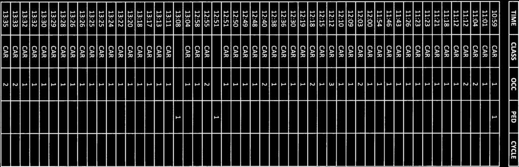
64
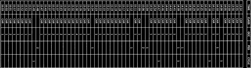

65
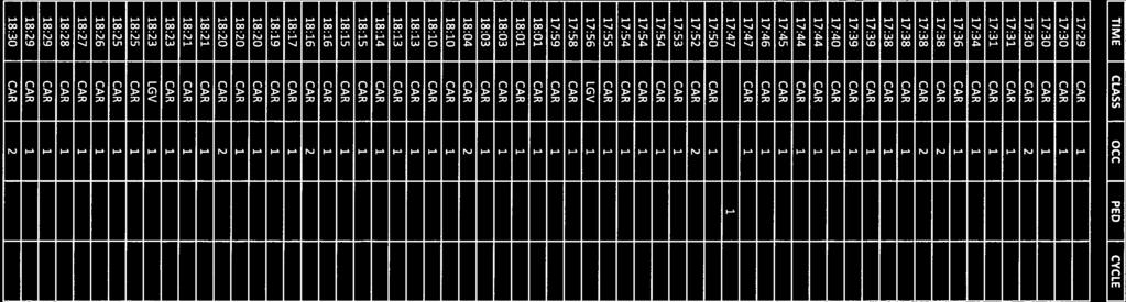

66

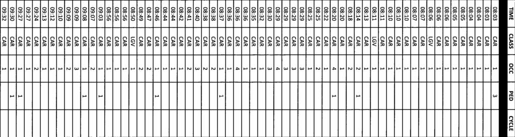
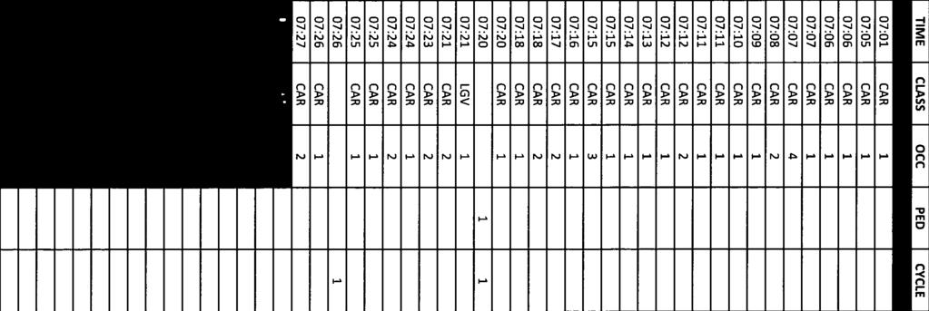
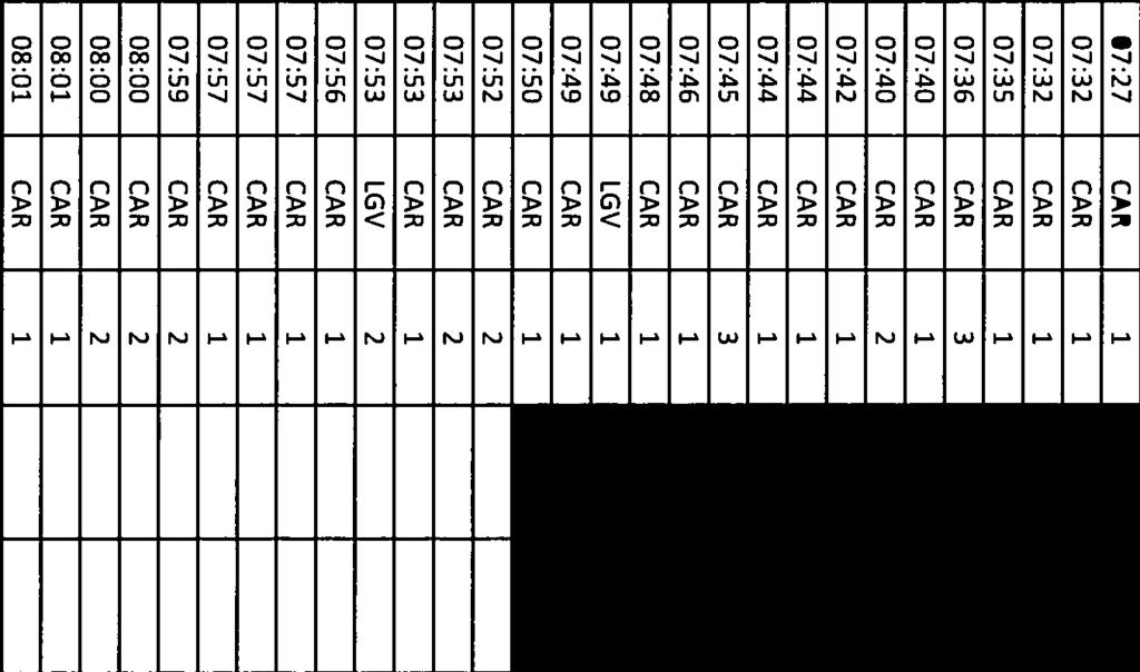


67
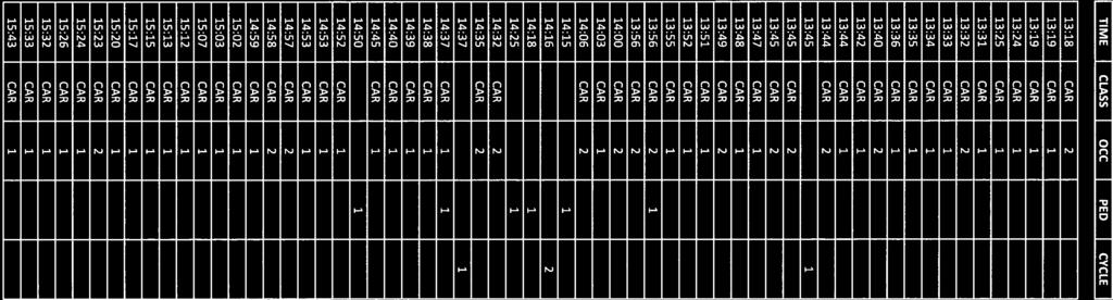
68

69
70 APPENDIX E Residential Travel Plan August 2017
 from developing company or representative Production of Travel Welcome Pack Provision of Welcome Packs: Information on pedestrian & cycle routes, public transport timetable, discounts, 30 cash")
71 RESIDENTIAL TRAVEL PLAN LAND WEST OF BARFORD RD, ST NEOTS KNIGHTS PARK APPENDIX E TIMETABLE OF MEASURES AUGUST 2017 Travel Plan Measures & Initiatives Appointment of a Travel Plan Coordinator (TPC) from developing company or representative Production of Travel Welcome Pack Provision of Welcome Packs: Information on pedestrian & cycle routes, public transport timetable, discounts, 30 cash back incentives etc. Knights Park travel website & Social Media Pages Training of Marketing Staff in principles of the Travel Plan and measures. Finalisation and Approval of Full Travel Plan Multi-modal Travel Survey Travel Summary Update Sheet Travel Plan Review Update the Travel Plan with results of multimodal survey, any changes to the development, local infrastructure, amenities in the area etc. Postal / Online Survey Public Transport Promotional Campaign to distribute a 1 week ticket for St Neots bus route. Car Sharing Travel Plan promotional event To be held at Knights Park Bicycle Surgery Completed. Completed. Completed. Implementation Set up completed. Regular update of information surrounding sustainable travel options including bus and rail timetables. Completed. Completed. Survey undertaken on third anniversary. Further multi-modal survey to be taken in 2018 and on the fifth anniversary in Surveys to be undertaken prior to any school holidays and around same time of year. High level leaflet to promote to residents and others the main outcomes of the multi-modal travel surveys and highlight the objectives of the Travel Plan and any measures available to them. Available through the Smarter Travel website and Knights Park Facebook page. Within 3 months after multi-modal travel surveys undertaken in July 2015, 2017 and Issue to Local Authority for approval. Undertaken on the third anniversary and to be repeated on the fifth anniversary. Surveys to be undertaken prior to any school holidays and around same time of year. Completed. Further promotion of public transport services to continue throughout monitoring period, including promotional information about local bus services and rail services. Promote the car sharing website managed by Cambridgeshire County Council through Knights Park residents Facebook page. Car sharing also promoted through promotional information distributed at third anniversary. Completed. Offer to residents at time of third anniversary and available on request. Page 1
Proposed Lidl Food store West Hendford, Yeovil
 Proposed Lidl Food store West Hendford, Yeovil Lidl Travel Plan October 2015 CONTENTS Page 1.0 INTRODUCTION 1 1.1 Background 1 1.2 Aim of Travel Plan 1 1.3 Contents 2 2.0 TRANSPORT CONTEXT 3 2.1 Site Location
Riverside Heights, Norwich. Travel Plan
 RIVERSIDE HEIGHTS, NORWICH Client: Engineer: Taylor Wimpey East Anglia Create Consulting Engineers Limited Hungate House Princes Street Norwich Norfolk NR3 1AZ Tel: 08454507908 Email: enquiries@createconsultingengineers.co.uk
Report to: Greater Cambridge Partnership Joint Assembly 18 January A10 Foxton level crossing bypass and travel hub
 Report to: Greater Cambridge Partnership Joint Assembly 18 January 2018 Lead officer: Chris Tunstall GCP Director of Transport A10 Foxton level crossing bypass and travel hub 1. Purpose 1.1 The list of
Citycourt Developments Ltd
 ouse Citycourt Developments Ltd Proposed Lidl Foodstore,, Dover Interim Travel Plan REPORT CONTROL Document: Travel Plan Project: Client: Citycourt Developments Ltd Job Number: 152045 File Origin: Document
John Betts School Crossing Review
 John Betts School Crossing Review Paddenswick Road London Borough of Hammersmith & Fulham August 2015 DOCUMENT CONTROL Project Centre has prepared this report in accordance with the instructions from the
Scotchbarn Lane, Prescot Accessibility Statement
 Scotchbarn Lane, Prescot Accessibility Statement Lancashire Mortgage Corporation Ltd August 2012 Issue R001B 9X0789 All rights reserved. No part of this publication may be reproduced in any form, including
20mph Speed Limit Zones
 Traffic Advisory Leaflet 7/91 May 1991 20mph Speed Limit Zones Summary This leaflet illustrates the main steps in the procedures for the implementation of 20mph zones. It provides brief details on: the
Gold Coast. Rapid Transit. Chapter twelve Social impact. Chapter content
 Gold Coast Rapid Transit Chapter twelve Social impact Chapter content Social impact assessment process...235 Existing community profile...237 Consultation...238 Social impacts and mitigation strategies...239
PERTH AND KINROSS COUNCIL. Housing and Health Committee. 25 May Perth and Kinross Local Housing Strategy
 PERTH AND KINROSS COUNCIL 7 16/234 Housing and Health Committee 25 May 2016 Perth and Kinross Local Housing Strategy 2016-2021 Report by Director (Housing and Social Work) PURPOSE OF REPORT This report
Response to the London Heathrow Airport Expansion Public Consultation
 Response to the London Heathrow Airport Expansion Public Consultation Summary This report sets out the response to the Heathrow Airport s consultation on airport expansion and airspace change. The consultation
EAST WEST RAIL EASTERN SECTION. prospectus for growth
 EAST WEST RAIL EASTERN SECTION prospectus for growth September 2018 executive summary The East West Rail Consortium, a partnership of local authorities, rail operators and Network Rail, continues to promote
Proposal for gypsy and traveller accommodation on land at Lower Hollow Copse (Pot Common), Copthorne. Statement of Community Involvement
, Copthorne. Statement of Community Involvement") Proposal for gypsy and traveller accommodation on land at Lower Hollow Copse (Pot Common), Copthorne Statement of Community Involvement Prepared by WYG Environment Planning Transport Ltd on behalf of the
Proposal for gypsy and traveller accommodation on land at Lower Hollow Copse (Pot Common), Copthorne Statement of Community Involvement Prepared by WYG Environment Planning Transport Ltd on behalf of the
Level Crossing Risk Assessment Polegate MCB
 Level Crossing Risk Assessment Polegate MCB Polegate MCB Level Crossing Risk Assessment 1 CONTENTS 1 INTRODUCTION 3 1.1 Background 3 1.2 Reason for the risk assessment 3 2 DESCRIPTION OF THE SITE 4 2.1
Roundhouse Way Transport Interchange (Part of NATS City Centre Package)
") Roundhouse Way Transport Interchange (Part of NATS City Centre Package) 15/16 16/17 17/18 18/19 19/20 Total TOTAL COST Roundhouse Way Transport Interchange 0.5m 0.5m FUNDING CIL 0.05m 0.05m Growth Deal
Roundhouse Way Transport Interchange (Part of NATS City Centre Package) 15/16 16/17 17/18 18/19 19/20 Total TOTAL COST Roundhouse Way Transport Interchange 0.5m 0.5m FUNDING CIL 0.05m 0.05m Growth Deal
Movement Strategy. November On behalf of Barton Oxford LLP
 Movement Strategy November 2014 On behalf of Barton Oxford LLP BARTON PARK, OXFORD. Movement Strategy 17/11/2014 Quality Management Issue/revision Issue 1 Revision 1 Revision 2 Revision 3 Remarks Date
Date: 11 th January, From: Plaistow & Ifold Parish Neighbourhood Plan - Steering Group. Plaistow & Ifold Parish Council
 Date: 11 th January, 2017 From: Plaistow & Ifold Parish Neighbourhood Plan - Steering Group To: Plaistow & Ifold Parish Council Re: Neighbourhood Plan Report to Parish Council Meeting 17 Jan 2017 The Steering
2.2 For these reasons the provision of tourist signing will only be considered:
 TOURIST SIGNING POLICY 2015 1. DEFINITION 1.1 A tourist destination is defined as a permanently established attraction which attracts or is used by visitors to an area and is open to the public without
Proposals for the Harrogate Road / New Line Junction Improvement Scheme. August / September Supported by:
 Proposals for the Harrogate / New Line Junction Improvement Scheme August / September 2016 Supported by: Introduction Key Benefits Proposals are currently being developed for changes to the junction of
Chapter 6 Route Window NE5 Seven Kings station. Transport for London
 Chapter 6 Route Window NE5 Seven Kings station Transport SEVEN KINGS STATION 6 Route Window NE5 Seven Kings Station Transport Introduction 6.1 All construction activities in this route window are associated
A TRANSPORT SYSTEM CONNECTING PEOPLE TO PLACES
 THE MAYOR'S VISION FOR TRANSPORT A TRANSPORT SYSTEM CONNECTING PEOPLE TO PLACES VISION We will build a transport system that works for everyone, connecting people to the places they want to go within the
Regulatory Committee
 Page 1 - Proposed Turning Movement Bans at South Gate Junction, Dorchester Regulatory Committee Date of Meeting 16 March 2017 Officer Subject of Report Executive Summary Andrew Martin Service Director
ACORNS PROJECTS LIMITED
 ACORNS PROJECTS LIMITED A4 London Road, M4 J5 to Sutton Lane, Slough, Berkshire Combined Stage 1 and 2 Road Safety Audit For Slough Borough Council Prepared by Acorns Projects Limited Safety Traffic Project
5 Rail demand in Western Sydney
 5 Rail demand in Western Sydney About this chapter To better understand where new or enhanced rail services are needed, this chapter presents an overview of the existing and future demand on the rail network
Land at Burton Road, Tutbury - Residential
 Land at Burton Road, Tutbury - Residential Prepared by: Developer Eyes 16 Brooklands Court Kettering Venture Park Kettering Northamptonshire NN15 6FD Author: Hannah Weston Our Ref: PS-120 Date: 28/07/2016
London Borough of Barnet Traffic & Development Design Team
 London Borough of Barnet Traffic & Development Design Team AERODROME ROAD PEDESTRIAN FACILITY AND BUS STOP INTRODUCTION FEASIBILITY REPORT Job Number: 60668 Doc Ref: S106/12-13/60668 Author: Manoj Kalair
Agenda Item 5: Rail East Midlands Rail Franchise Consultation
 Strategic Transport Forum 15 th September 2017 Agenda Item 5: Rail East Midlands Rail Franchise Consultation Recommendation: It is recommended that the Forum agree (subject to any amendments agreed by
Saighton Camp, Chester. Technical Note: Impact of Boughton Heath S278 Works upon the operation of the Local Highway Network
 Technical Note: Impact of Boughton Heath S278 Works July 2013 SAIGHTON CAMP CHESTER COMMERCIAL ESTATES GROUP TECHNICAL NOTE: IMPACT OF BOUGHTON HEATH S278 WORKS UPON THE OPERATION OF THE LOCAL HIGHWAY
Rail Delivery Group. Consultation on the future of the East Midlands rail franchise
 Rail Delivery Group Response to: Department for Transport Consultation on the future of the East Midlands rail franchise Date: 11 October 2017 Rail Delivery Group Limited Registered Office, 2nd Floor,
Wokingham Borough Council Response to the Consultation on the Draft Airports National Policy Statement
 Wokingham Borough Council Response to the Consultation on the Draft Airports National Policy Statement The consultation Draft Airports National Policy Statement (Draft NPS) sets out Government s policy
Commissioning Director - Environment
 Finchley and Golders Green Area Committee 27 April 2017 Title Report of Wards Status Urgent Key Enclosures Summers Lane,N12 Request for Pedestrian Improvements Commissioning Director - Environment Woodhouse
SAMTRANS TITLE VI STANDARDS AND POLICIES
 SAMTRANS TITLE VI STANDARDS AND POLICIES Adopted March 13, 2013 Federal Title VI requirements of the Civil Rights Act of 1964 were recently updated by the Federal Transit Administration (FTA) and now require
Lower Thames Crossing consultation response
 Lower Thames Crossing consultation response Context: This is the response from Campaign for Better Transport to the Department for Transport s consultation Options for a new Lower Thames Crossing. Consultation
WELCOME TO PROJECT EVERGREEN 3 CHILTERN S PROPOSED NEW OXFORD TO LONDON ROUTE
 PROJECT EVERGREEN 3 WELCOME TO PROJECT EVERGREEN 3 CHILTERN S PROPOSED NEW OXFORD TO LONDON ROUTE Chiltern Railways is proposing a railway improvement scheme between Oxford and Bicester (the Evergreen
Hertford Way, Knowle, Solihull - Residential
 Hertford Way, Knowle, Solihull - Residential Prepared by: Developer Eyes 16 Brooklands Court Kettering Venture Park Kettering Northamptonshire NN15 6FD Author: Grant Morgan Our Ref: PS-150 Date: 14/04/2016
The case for a local rail station. At Great Blakenham, Suffolk.
 The case for a local rail station At Great Blakenham, Suffolk. The London to Norwich (Great Eastern) main rail line passes through Great Blakenham in Suffolk, a village which adjoins Claydon and Barham.
Llandudno Junction. Regeneration Proposals for the Future. December 2009
 Llandudno Junction Regeneration Proposals for the Future December 2009 Llandudno Junction - Vision Statement 1 Purpose 1.1 The purpose of this document is to describe key priorities to support the regeneration
Chapter 2 Route window W25 Maidenhead station. Transport for London
 Chapter 2 Route window W25 Maidenhead station MAIDENHEAD STATION 2 Route window W25 Maidenhead station 2.6 The drawings provided at the end of this chapter present the main features of the route window,
Regulating Air Transport: Department for Transport consultation on proposals to update the regulatory framework for aviation
 Regulating Air Transport: Department for Transport consultation on proposals to update the regulatory framework for aviation Response from the Aviation Environment Federation 18.3.10 The Aviation Environment
The decision on whether to take enforcement action falls outside the scope of delegated powers.
 5k 16/0031 Reg d: 19.01.2016 Expires: 15.03.201 6 Ward: Nei. 24.02.201 BVPI Full Number of 11/8 On Con. 6 Target Weeks on Target? Exp: Cttee Day: GE No LOCATION: PROPOSAL: TYPE: Phillips Court, 32 Goldsworth
33 Horseferry Road HP20 1UA London SW1P 4DR. Tuesday 10 th October Dear Sir,
 East Midlands Rail Franchise Programme Office Consultation Co-ordinator c/o Buckinghamshire County Council Zone 2/21 County Hall Department for Transport Walton Street Great Minster House Aylesbury 33
Investing in Greater Manchester transport 2017/2018
 TRAFFIC Investing in Greater Manchester transport 2017/2018 INFORMATION www.greatermanchester-ca.gov.uk Transport is an important part of life for residents and businesses in Greater Manchester. It connects
TRANSPORT FOR GREATER MANCHESTER COMMITTEE REPORT FOR RESOLUTION
 TRANSPORT FOR GREATER MANCHESTER COMMITTEE REPORT FOR RESOLUTION DATE: 11 November 2011 SUBJECT: REPORT OF: Proposed making of a Quality Partnership Scheme for the A6 corridor between Manchester and Hazel
Map showing location of public transport projects in vicinity of railway station
 Map showing location of public transport projects in vicinity of railway station Market Town Transport Strategy 2013 39 ID PT1a Specific Location Approach at Detail of Project Develop Area Master plan
Date: 22 September Grove Vale parking consultation. East Dulwich, South Camberwell. Head of Public Realm
 Item. 11 Report title: Ward(s) or groups affected: From: Classification: Open Date: 22 September 2011 Decision Taker: Camberwell Community Council Grove Vale parking consultation East Dulwich, South Camberwell
North West London Hospitals NHS Trust
 North West London Hospitals NHS Trust Policy Communication Cover Sheet Policy Name: Post Holder Responsible: Approved by: Replaces: PARKING POLICY Philip Sutcliffe, Director of Corporate Services Executive
TRANSPORT & INFRASTRUCTURE PLANNING NSPORT & INFRASTRUCTURE PLANNING SOWDEN TRANSPORT GROUP AND INFRASTRUCTURE PLANNING WINDMILL PLACE, LOUGHBOROUGH
 TRANSPORT & INFRASTRUCTURE PLANNING SOWDEN TRANSPORT GROUP AND INFRASTRUCTURE PLANNING WINDMILL PLACE, LOUGHBOROUGH NSPORT & INFRASTRUCTURE PLANNING TRAVEL Wilson Bowden PLAN Developments Woodhouse Park
Oxted Parking Review 17/02/2017 Reference number /12 PARKING BASELINE STUDY
 Oxted Parking Review 17/02/2017 Reference number 104380/12 PARKING BASELINE STUDY OXTED PARKING REVIEW PARKING BASELINE STUDY IDENTIFICATION TABLE Client/Project owner Project Study Type of document Tandridge
Your Transport Levy Your Transport Future. Sunshine Coast Council Transport Levy Annual Report
 Your Transport Levy Your Transport Future Sunshine Coast Council Transport Levy Annual Report 2016-2017 www.sunshinecoast.qld.gov.au T 07 5475 7272 F 07 5475 7277 Locked Bag 72 Sunshine Coast Mail Centre
November 11, 2009 BY . Planning and Growth Management Department 110 Laurier Avenue West, 4 th Floor Ottawa, Ontario K1P 1J1. Dear Mr.
 November 11, 2009 Planning and Growth Management Department 110 Laurier Avenue West, 4 th Floor Ottawa, Ontario K1P 1J1 BY E-MAIL Attention: Mr. Don Herweyer Dear Mr. Herweyer: Reference: Abbott-Fernbank
Tesco, Swan Shopping Centre, Coventry Road, Yardley, Birmingham, B26 1AD
 Committee Date: 18/04/2013 Application Number: 2013/00607/PA Accepted: 30/01/2013 Application Type: Variation of Condition Target Date: 01/05/2013 Ward: South Yardley Tesco, Swan Shopping Centre, Coventry
NEW BRIGHTON Travel Plan October 2008
 FLORAL PAVILION NEW BRIGHTON Travel Plan October 2008 1 FLORAL PAVILION comprises FLORAL PAVILION THEATRE Capacity 814 seats FLORAL PAVILION CONFERENCE CENTRE Tivoli Suite maximum capacity 50 Tower Room
M621. Junctions 1 to 7 Improvement scheme. Share your views
 M621 Junctions 1 to 7 Improvement scheme Share your views Investing in your roads Every road user wants less congested roads to enable swift, safe, comfortable and informed travel. On behalf of the government,
PUBLIC INQUIRY APPLICATION BY NEWTWORK RAIL UNDER TRANSPORT AND WORKS ACT 1992 PROPOSED NETWORK RAIL SUFFOLK LEVEL CROSSING REDUCTION ORDER
 PUBLIC INQUIRY APPLICATION BY NEWTWORK RAIL UNDER TRANSPORT AND WORKS ACT 1992 PROPOSED NETWORK RAIL SUFFOLK LEVEL CROSSING REDUCTION ORDER OBJ/27-FOREST HEATH DISTRICT COUNCIL PROOF OF EVIDENCE S22 Weatherby
Leighton Buzzard Station Travel Plan
 Leighton Buzzard Station Travel Plan 1 Introduction Welcome to the Station Travel Plan for the What is a Station Travel Plan? station of Leighton Buzzard. Through this Station Travel Plan, over the next
Queen s Circus Roundabout
 Stage 2 Road Safety Audit Ref: 1128-RSA-01 Prepared for: Steer Davies Gleave By: Capital Traffic Prepared by: Checked by: Approved by: Andy Haunton, Audit Team Leader Jonathan Thompson, Audit Team Member
AIRPORT SURFACE ACCESS STRATEGY
 AIRPORT SURFACE ACCESS STRATEGY August 2006 SOUTHEND AIRPORT AIRPORT SURFACE ACCESS STRATEGY July 2006 CONTENTS Page Introduction 3 National, Regional and Local Transport Policies 3 The Airport Transport
Speed control humps - Scotland, England and Wales
 Traffic Advisory Leaflet 3/91 September 1991 Speed control humps - Scotland, England and Wales Introduction Road humps are an extremely effective means of keeping vehicle speeds low. The standard round
Local Development Scheme
 Local Development Scheme August 2014 Local Development Scheme (August 2014) / Page 2 Contents Section 1: Introduction Great Yarmouth s Development Plan 4 Section 2: Plan Making Process Public participation
Construction Staging Adelaide Street West
 REPORT FOR ACTION Construction Staging Adelaide Street West Date: October 6, 2016 To: Toronto and East York Community Council From: Acting Director, Transportation Services, Toronto and East York District
Sky Temporary Car Park Transport Statement
 001 Issue 26 August 2016 This report takes into account the particular instructions and requirements of our client. It is not intended for and should not be relied upon by any third party and no responsibility
URBAN DESIGN REPORT. Proposed Residential Development, Old Church Road, Caledon East
 Proposed Residential Development, Old Church Road, Caledon East TABLE CONTENTS: 1.0 DEVELOPMENT 1.1 Introduction-Analysis of Guiding Principles and Documents 1.2 Community Design and Architectural Design
Member-led Review of Cycling Infrastructure
 Member-led Review of Cycling Infrastructure Survey Results: Hills Road, Cambridge June 2017 0 cambridgeshire.gov.uk Contents 1. Introduction... 3 2. About you... 3 2.1 Age... 3 2.2 What is your gender?...
Tesco Express, Alcester Road South, Kings Heath, Birmingham, B14 6EB
 Committee Date: 27/11/2014 Application Number: 2014/06477/PA Accepted: 09/09/2014 Application Type: Variation of Condition Target Date: 09/12/2014 Ward: Brandwood Tesco Express, 281-289 Alcester Road South,
Bridge School, Longmoor Campus, Coppice View Road, Sutton Coldfield, Birmingham, B73 6UE
 Committee Date: 22/01/2015 Application Number: 2014/05949/PA Accepted: 08/12/2014 Application Type: Full Planning Target Date: 02/02/2015 Ward: Sutton Vesey Bridge School, Longmoor Campus, Coppice View
A303. Sparkford to Ilchester Dualling Scheme Preferred Route Announcement
 A303 Sparkford to Ilchester Dualling Scheme Preferred Route Announcement About this booklet This booklet presents the preferred route for the A303 Sparkford to Ilchester dualling scheme and a summary of
2015/16. Council LOGO ATTRACTIVE SEAMLESS RELIABLE IMPROVED CONNECTIVITY ACCESS FOR ALL REDUCED EMISSIONS
 2015/16 Council LOGO 0 ABOUT US Strathclyde Partnership for Transport (SPT) is the Regional Transport Partnership for the west of Scotland and is a partnership of twelve councils. SPT was established by
FUTURE AIRSPACE CHANGE
 HEATHROW EXPANSION FUTURE AIRSPACE CHANGE UPDATE SEPTEMBER 2018 On 25 June 2018, Parliament formally backed Heathrow expansion, with MPs voting in support of the Government s Airports National Policy Statement
Guildford Borough Transport Strategy 2017, Topic Paper: Transport, June 2017 (accompanying Local Plan 2017) Local Plan Transport Strategy 2017
 Local Plan Transport Strategy 2017") Guildford Society Transport Group Position Paper August 2017 Based on submissions in response to the June/July 2017 Local Plan consultation including material presented to Drop-in Session 15 July 2017.
Guildford Society Transport Group Position Paper August 2017 Based on submissions in response to the June/July 2017 Local Plan consultation including material presented to Drop-in Session 15 July 2017.
Norwich Research Park Overarching Travel Plan November 2017
 Norwich Research Park Overarching Travel Plan November 2017 Norwich Research Park Overarching Travel Plan November 2017 Contents Page 1 Norwich Research Park Site & Development Proposals... 1 2 Site Location
BLOOR HOMES LTD PROPOSED RESIDENTIAL DEVELOPMENT LAND EAST OF GROBY CEMETERY, GROBY, LEICESTERSHIRE TRAVEL PLAN
 BLOOR HOMES LTD PROPOSED RESIDENTIAL DEVELOPMENT LAND EAST OF GROBY CEMETERY, GROBY, LEICESTERSHIRE TRAVEL PLAN Northern Transport Planning Ltd Suite 7, Vincent House, 136 Westgate, Wakefield, WF2 9SR
All reports. 1. Governance Service receive draft report Name of GSO DPR
 DELEGATED POWERS REPORT NO. SUBJECT: Redevelopment at Grahame Park Estate, NW9, Phase 1B Sub-phase 1 Highways Agreement under Sections 38 and 278 of the Highways Act 1980. Control sheet All of the following
TOWN PLANNING SUBMISSION TO THE GREATER SYDNEY COMMISSION LANDS AT ARTARMON
 TOWN PLANNING SUBMISSION TO THE GREATER SYDNEY COMMISSION LANDS AT ARTARMON March 2017 TABLE OF CONTENTS 1.0 INTRODUCTION 3 2.0 THE SUBJECT SITE 4 3.0 STRATEGIC PLANNING CONTEXT 6 4.0 SUMMARY AND CONCLUSIONS
Perth and Kinross Council Development Control Committee 27 August 2008 Recommendation by Development Quality Manager
 Perth and Kinross Council Development Control Committee 27 August 2008 Recommendation by Development Quality Manager 5(7) 08/414 Erection of kennels and cattery at Baltree Farm, Hatchbank, Kinross, KY13
Major Scheme Business Case Summary Report for Programme Entry
 Paper A Heart of South West Local Transport Board Major Scheme Business Case Summary Report for Programme Entry M5 Junction 25, Taunton July 2016 1 SCHEME SUMMARY Scheme Name M5 Junction 25, Taunton Date
Appendix 6 Fulbourn Greenway Review
 Appendix 6 Fulbourn Greenway Review Nigel Brigham & Associates A report for 1 Introduction This report is based on fieldwork carried out in 2016 to review the Greenway network around Cambridge as shown
Old Limberlost Sports Club, Butlers Road, Handsworth Wood, Birmingham, B20 2NT
 Committee Date: 07/03/2013 Application Number: 2012/07986/PA Accepted: 29/11/2012 Application Type: Variation of Condition Target Date: 24/01/2013 Ward: Handsworth Wood Old Limberlost Sports Club, Butlers
7. CONSULTATION ON THE TRAVELLER SITES ALLOCATIONS DOCUMENT
 7. CONSULTATION ON THE TRAVELLER SITES ALLOCATIONS DOCUMENT REPORT OF: HEAD OF ECONOMIC PROMOTION AND PLANNING Contact Officer: Nathan Spilsted, Senior Planning Officer Email: nathan.splistead@midsussex.gov.uk
Travel Plan For Proposed Nishkam School West London Prepared on behalf of BAM Construction Ltd Nishkam School West London, Syon Lane, Hounslow
 For Proposed Nishkam School West London Prepared on behalf of BAM Construction Ltd Nishkam School West London, Syon Lane, Hounslow Acknowledgements: The TRICS database has been used in this report to assess
Railfuture East Anglia Whittlesford Parkway station audit
 Railfuture East Anglia Whittlesford Parkway station audit Introduction and summary of findings This report details the findings of a station audit carried out by members of Railfuture East Anglia Branch
Member-led Review of Cycling Infrastructure
 Member-led Review of Cycling Infrastructure Survey Results: Huntingdon Road, Cambridge June 217 cambridgeshire.gov.uk Contents 1. Introduction... 3 2. About you... 3 2.1 Age... 3 2.2 What is your gender?...
2.0 POLICY AND DEVELOPMENT FRAMEWORK. Introduction. Transport21. Celbridge Development Plan 2002
 2.0 POLICY AND DEVELOPMENT FRAMEWORK Introduction 2.1 This section of the report highlights the key elements of both Transport21, and the Celbridge Development Plan 2002, both of which include a number
Accommodation Survey: November 2009
 Embargoed until 10:45am 19 January 2010 Accommodation Survey: November 2009 Highlights Compared with November 2008: International guest nights were up 2 percent, while domestic guest nights were down 1
Kent Pedestrian Guard Railing Assessment
 Kent Pedestrian Guard Railing Assessment Canterbury Final Report for JTB March 2012 Project Number B1649000 Jacobs Eng UK Ltd, Miller House, Lower Stone Street, Maidstone, Kent ME15 6GB Document control
Member-led Review of Cycling Infrastructure
 Member-led Review of Cycling Infrastructure Survey Results: A1 Cambridge to Royston June 17 cambridgeshire.gov.uk Contents 1. Introduction... 3. About you... 3.1 Age... 3. What is your gender?... 3.3 Do
PART VIII APPLICATION FOR REVISED SOUTH SIDE TRAFFIC MANAGEMENT WORKS TO FACILITATE LUAS BXD PLANNING REPORT ROADS & TRAFFIC DEPARTMENT
 PART VIII APPLICATION FOR REVISED SOUTH SIDE TRAFFIC MANAGEMENT WORKS TO FACILITATE LUAS BXD PLANNING REPORT ROADS & TRAFFIC DEPARTMENT NOVEMBER 2012 1.0 INTRODUCTION This report has been prepared in support
Road Investment Strategy A1 East of England Strategic Road Study
 Road Investment Strategy 2020-2025 A1 East of England Strategic Road Study Report of the fourth meeting of the Stakeholder Reference Group March 2017 The fourth meeting of the A1 Stakeholder Reference
HEAD OF ECONOMIC PROMOTION AND PLANNING Nathan Spilsted, Senior Planning Officer Tel:
 7. TRAVELLER SITES ALLOCATIONS DOCUMENT REPORT OF: Contact Officer: Wards Affected: Key Decision: Report to: HEAD OF ECONOMIC PROMOTION AND PLANNING Nathan Spilsted, Senior Planning Officer Email: nathan.spilsted@midsussex.gov.uk
Kent Pedestrian Guard Railing Assessment
 Kent Pedestrian Guard Railing Assessment Canterbury - Consultation Report November 2010 Project Number B1555300 Jacobs Eng UK Ltd, Miller House, Lower Stone Street, Maidstone, Kent ME15 6GB Document control
FREEHOLD FOR SALE Prime Residential Development Opportunity
 Prime Cambridgeshire residential development opportunity (subject to necessary planning consents) Prominent riverside location Potential for high density residential scheme Draft allocation for circa 90
Re-opening of the Skipton to Colne Railway Executive Summary
 Re-opening of the to Colne Railway Executive Summary SELRAP SELRAP is the East Lancashire Rail Action Partnership. It was established with the objective of campaigning for the reinstatement of the railway
TRANSPORT AND WORKS ACT Proof of Evidence. Andrew Wright Planning and Design Manager Taylor Wimpey East Anglia
 TRANSPORT AND WORKS ACT 1992 Proof of Evidence Andrew Wright Planning and Design Manager Taylor Wimpey East Anglia The Network Rail (Suffolk Level Crossing Reduction Order) Site at Elmswell Development
TOWN TRUST. Bury St Edmunds Railway Station
 BURY ST EDMUNDS TOWN TRUST conserving buildings of historic interest The future of Bury St Edmunds Railway Station Part I Report October 2015 1 The future of Bury St Edmunds Railway Station NOTE: This
Blackburn Road Blackburn Level Crossing Removal. Frequently Asked Questions August 2014 GENERAL
 Frequently Asked Questions August 2014 Blackburn Road Blackburn Level Crossing Removal GENERAL What is the project? The Victorian Government has committed to eliminating a number of the busiest level crossings
Report of the Strategic Director of Place to the meeting of Executive to be held on 11 September 2018
 Report of the Strategic Director of Place to the meeting of Executive to be held on 11 September 2018 Subject: M Arrangements for the establishment of a West Yorkshire Urban Traffic Management Control
Appendix 8 Sawston Greenway Review
 Appendix 8 Sawston Greenway Review Nigel Brigham & Associates A report for 1 Introduction This report is based on fieldwork carried out in 2016 to review the Greenway network around Cambridge as shown
Tram Passenger Survey
 Key findings Autumn 2015 Foreword Jeff Halliwell Now in its third year, our Tram Passenger Survey has covered passengers views of their journey in six network areas in Britain. For the second time this
Transport Assessment Appendix M: Avonmouth Impacts
 Portishead Branch Line (MetroWest Phase 1) Environmental Impact Assessment Transport Assessment Appendix M: Avonmouth Impacts Prepared for West of England Councils December 2016 1 The Square Temple Quay
Non-technical summary
 Introduction NTS1 NTS2 NTS3 Troika Developments Ltd (Troika) has submitted a planning application to Bournemouth Borough Council (BBC) for an extension of time to implement planning permission 7/2004/16450/G,
SOUTH CAMBRIDGESHIRE DISTRICT COUNCIL. Executive Director / Senior Planning Policy Officer
 SOUTH CAMBRIDGESHIRE DISTRICT COUNCIL REPORT TO: Leader and Cabinet 8 May 2008 AUTHOR/S: Executive Director / Senior Planning Policy Officer SOUTH CAMBRIDGESHIRE DISTRICT COUNCIL S RESPONSE TO UTTLESFORD
NATIONAL AIRSPACE POLICY OF NEW ZEALAND
 NATIONAL AIRSPACE POLICY OF NEW ZEALAND APRIL 2012 FOREWORD TO NATIONAL AIRSPACE POLICY STATEMENT When the government issued Connecting New Zealand, its policy direction for transport in August 2011, one