The role of Primeval Beech Forests in the Carpathians in regional water management
|
|
|
- Aron Patrick
- 5 years ago
- Views:
Transcription
1 The role of Primeval Beech Forests in the Carpathians in regional water management Lubos Jurík Klaudia Halászová Zlatica Muchová Jozef Halva Slovak University of Agriculture in Nitra Slovakia
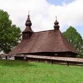
2 UNESCO Sites Cultural (5) Bardejov Town Conservation Reserve (2000) Historic Town of Banská Štiavnica and the Technical Monuments in its Vicinity (1993) Levoča, Spišský Hrad and the Associated Cultural Monuments (1993) Vlkolínec (1993) Wooden Churches of the Slovak part of the Carpathian Mountain Area (2008) Natural (2) Ancient and Primeval Beech Forests of the Carpathians and Other Regions of Europe (2007) Caves of Aggtelek Karst and Slovak Karst (1995)

3

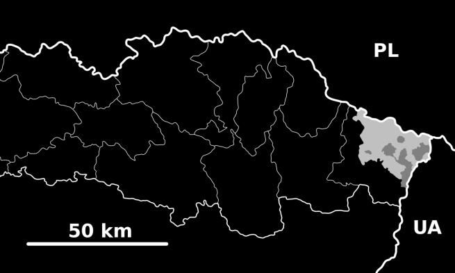
4 3 National Parks SK PL UA

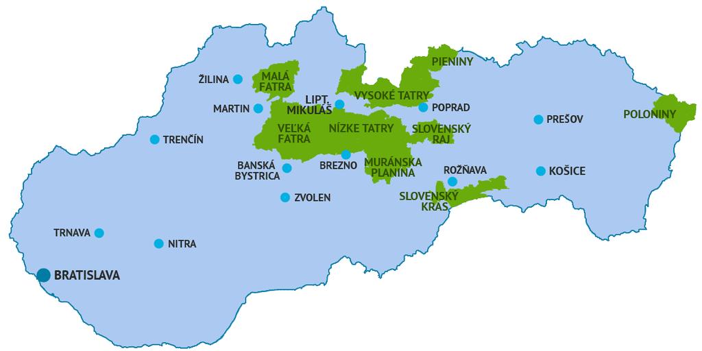
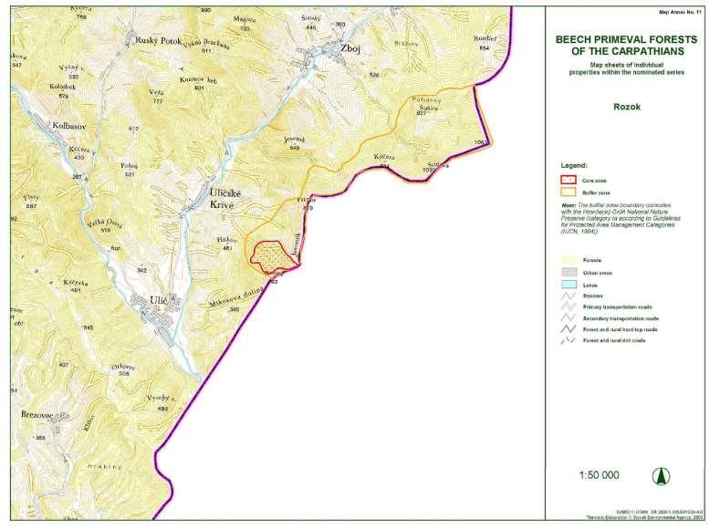
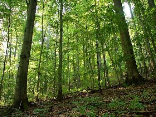
5 3 Primeval Beech Forests
6 3 Primeval Beech Forests

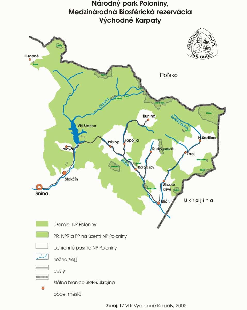
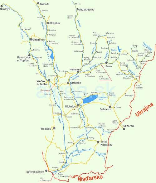
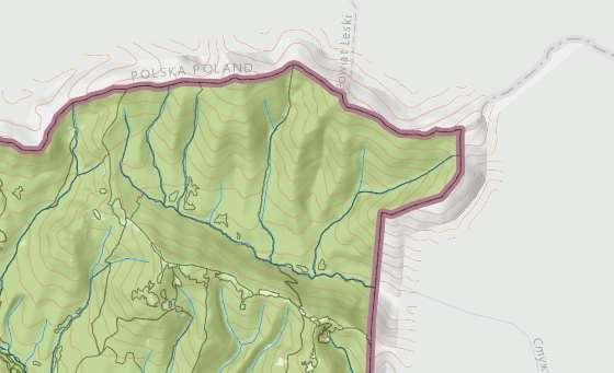
7 Poloniny The Poloniny National Park was declared on October 1, 1997 on an area of km² with a protection zone of km².

8 Poloniny
9
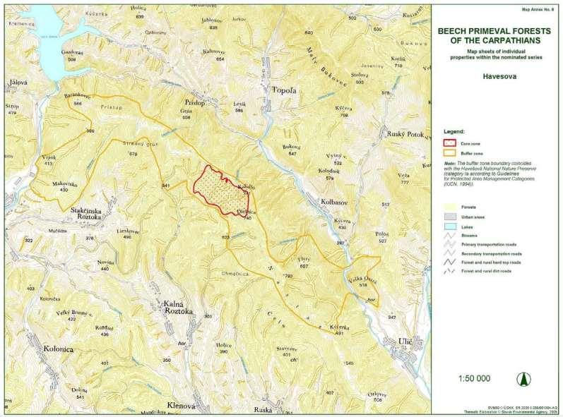
10 Ancient and Primeval Beech Forests of the Carpathians and Other Regions of Europe This transboundary extension of the World Heritage site of the Primeval Beech Forests of the Carpathians and the Ancient Beech Forests of Germany (Germany, Slovakia, Ukraine) now stretches over 12 countries. Since the end of the last Ice Age, European beech spread from a few isolated refuges in the Alps, Carpathians, Mediterranean and Pyrenees over a short period of a few thousand years in a process that is still ongoing. This successful expansion is related to the tree s flexibility and tolerance of different climatic, geographical and physical conditions.
11 Ancient and Primeval Beech Forests of the Carpathians and Other Regions of Europe Date of Inscription: 2007 Extension: 2011,2017 Criteria: (ix) to be outstanding examples representing significant on-going ecological and biological processes in the evolution and development of terrestrial, fresh water, coastal and marine ecosystems and communities of plants and animals; Property : Buffer zone: 92, ha 253, ha
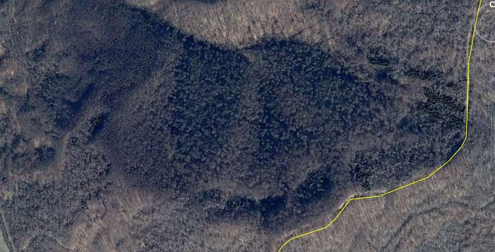
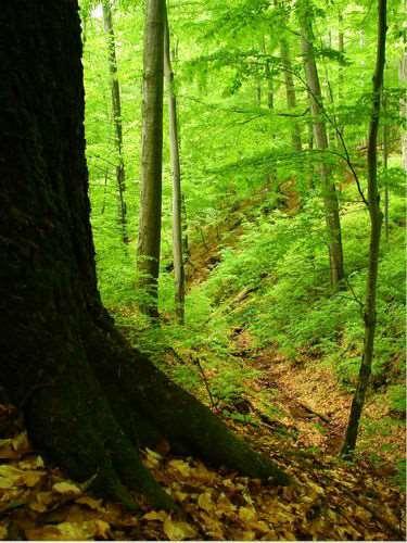
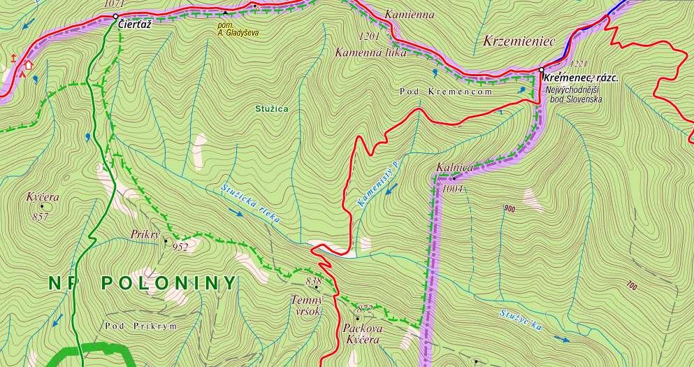
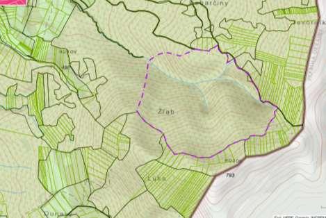
12 Rožok (Slovak Republic) The site, one of the most productive beech primeval forests on the Slovak territory. It is a national nature preserve embedded in the B-zone of the Poloniny National Park. The property is located in the Bukovské Vrchy (Bukovské Hills), in its part Kremencové Pohorie (Kremencové Mts.), northeast of Ulič, a village in the Snina District. It touches the boundary between Slovakia and Ukraine and borders on the Ukrainian Uzhansky National Nature Park (UNNP). The national nature preserve extends at the elevation m a.s.l., on a NW slope from sandstones and claystone slope deposits within the outer Carpathian flysch belt. Its largest part is underlain by a rhythmic series of thinly flysch layers. Thin layers of sandstone and various claystones are superimposed on each other.
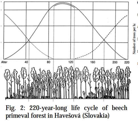
13
14 Rožok (Slovak Republic) The average yearly temperature is 7 ºC, the annual precipitation ranges 780 mm and the vegetation period lasts about 190 days. Its climate has been classified in the mildly warm mountainous and moderately cold mountainous climatic-geographical types. Cambisols rich in humus have gradually formed on light grey daze sandstones and dark grey marl-clay slates. They are eutric to mesotrophical, sandy clays, loamy clays and loams with featuring good water, air and nutrients regimes. These soils provide the basis for a higly productive primeval beech forest with the average age of trees 130 years, 210 years in the main canopy. The average standing volume ranges from 577 to 794 m 3 ha 1.
15 Rožok (Slovak Republic) The reserve is drained by Zbojský Potok brook that mouthing into Stužica River, which in turn drains into the Uh River and is a part of the Bodrog River watershed.
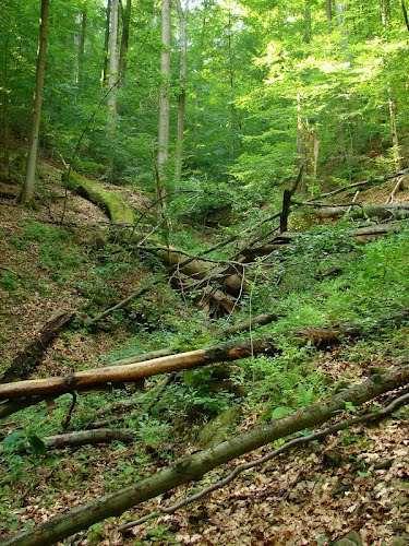
16 Rožok National Nature Reserve contains nearly homogeneous beech forests with significantly variable height and diameter structure. Its developmental cycle lasts years. The developmental stages occur within spatially restricted small patches and can be delineated based on the proportion of trees within the middle overstorey and the average diameter of trees from the upper overstorey. According to the latest research, which was carried out in 1999, most forests of the reserve are in the maturation developmental stage (45-50 % of the area of the reserve), followed by the senescence stage (30-35%), and the optimum stage (20-25%). Shelterwood regeneration takes place in the reserve s forests within small are patches and groups. Developmental independence is reached on 30 ha.
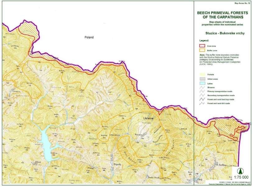
17 Havešová National Nature Reserve Since the site is currently designated as a National Nature Reserve, and it is a part of the Poloniny National Park, which was awarded a European diploma by the European Council in 1998, a system of protection measures is defined for it in the National Council of the Slovak Republic Act No. 543/2002 Coll. on Nature and Landscape Protection.
18
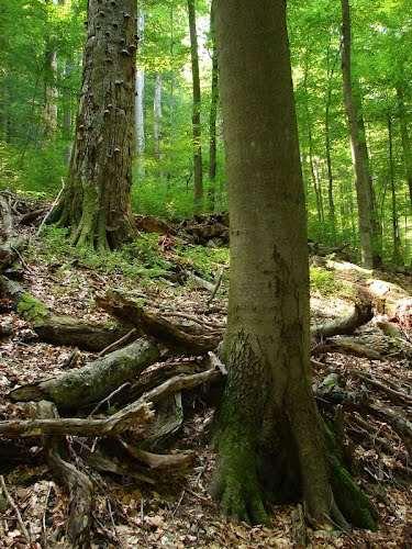
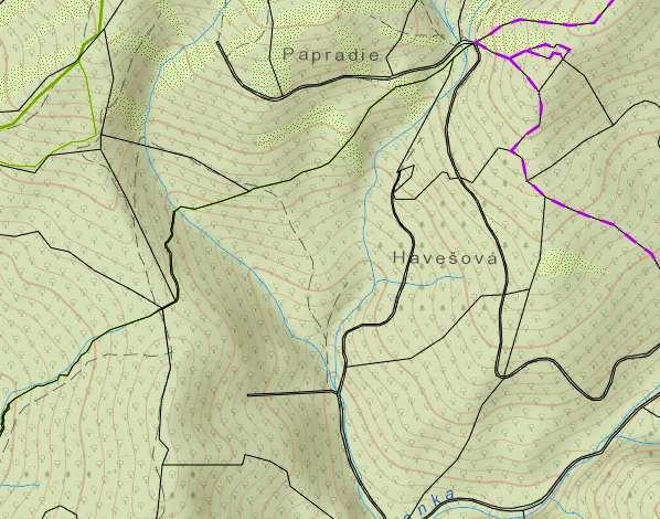
19 Havešová National Nature Reserve is located in the Nasta mountain range of the Bukovské Vrchy Mountains, in the Dukla unit of the Carpathian outer flysch belt, between the villages of Kalná Ráztoka and Stakčínska Ráztoka. It belongs administratively to Snina District. The reserve s primeval forest stands are located from 440 to 741 metres above sea level. The reserve is classified into the moderately warm mountainous climatic-geographical type. Mean annual temperature is C and the growing season lasts from days a year. The annual precipitation is mm, and snow cover can be observed for days a year.
20 Havešová National Nature Reserve contains nearly homogeneous beech forests with significantly variable height and diameter structure. Its developmental cycle lasts years. The developmental stages occur within spatially restricted small patches and can be delineated based on the proportion of trees within the middle overstorey and the average diameter of trees from the upper overstorey. According to the latest research, which was carried out in 1999, most forests of the reserve are in the maturation developmental stage (45-50 % of the area of the reserve), followed by the senescence stage (30-35%), and the optimum stage (20-25%). Shelterwood regeneration takes place in the reserve s forests within small are patches and groups. Developmental independence is reached on 30 ha
21 Havešová (Slovak Republic) The core area of the site is ha and the buffer zone is ha. The site has been designated as a National Nature Reserve in 1964 as a part of a larger complex of intact beech pimeval forests in the Nastaz Range.
22
23
24 Stužica - Bukovské Vrchy (Slovak Republic) Stužica Bukovské Vrchy is a contigeous complex of beech primeval forests that extends from the headwaters of the Udava River (Nízke Beskydy Mts.) in the North-West to the headwaters of Stužica River (Bukovské Vrchy Mts.) in the South East. The complex comprises four primeval forest preserves (Udava, Pľaša, Rjaba Skala and Stužica) and beech primeval forests of the A (core) zone of the Poloniny National Park. Its territory lies within the borders of Snina District. It touches the boundaries of Slovakia, Poland, and the Ukraine.
25 Stužica - Bukovské Vrchy (Slovak Republic) The territory is characterised by a great range in altitude, from 650 to 1121 metres above sea level. It has been classified in the mildly warm mountainous, moderately cold mountainous, and cold mountainous climatic-geographical types. Mean annual temperature in the reserve is ºC, and the growing season lasts 90 to 140 days. Annual precipitation is mm and snow cover is present days a year.
26 Stužica - Bukovské Vrchy (Slovak Republic) Primeval forest plant communities that are protected within the reserve occur within the 4th beech forest vegetation zone and 5th firbeech forest vegetation zone. The beech primeval forests complex contains some 200 year old beech (Fagus sylvatica) specimens and >300 year old clusters of silver fir (Abies alba) including exceptionally large individuals, as well as equally respectable sycamore (Acer pseudoplatanus) trees. Sycamore often occurs in stony gullies with common ash (Fraxinus excelsior). The presence of sycamore and rowan (Sorbus aucuparia) is even more visible on ridges in the reserve. A section of forest in the 4th forest vegetation zone, where beech is the dominant species, contains the highest proportional presence of fir of any primeval forest in eastern Slovakia. Its total volume percentage can reach 35%, but the number of fir individuals never exceeds 10% of the total tree number per hectare
27 Stužica - Bukovské Vrchy It is quite common for firtrees to outlive even 2 generations of beech. Fir diameter can reach cm, and its volume can exceed 30 m 3. The presence of fir makes itself felt most during the advanced phase of the maturation developmental stage of the 2nd beech generation, when there is the greatest height differentiation in stand structure. Fir abundance increases in the 5th forest vegetation zone of the reserve, but beech remains the core species and continues to determine the structure and development of forest stands. Fir is 20-30% of the total standing volume. Stands in this zone are characterized by a typical hierarchical structure that is sometimes multi-layered. Beech is regarded as the determinant species of the developmental cycle, which lasts 230 to 250 years. In the senescence developmental stage, the gradual elimination of surviving beech individuals is a characteristic process.

28 Kremenec Stužica

29

30
31
32 Wood production 2010 The structure of wood harvesting is as follows: woodcutting needles trees m3 woodcutting deciduous trees 54,923 m3 woodcutting upbringing 24,652 m3 calamity woodcutting m3 New tree planted

33 Stužický forest
34 Rožok
35

36

37 Stakčínska Roztoka By Daniel Fedin
38 WATER MANAGEMENT IN POLONINY

39 Poloniny
40
41 Stužica

42 Rožok

43 Havešová

44 Water Reservoir Starina

45 Starina reservoir Water reservoir Starina was constructed in years at upper part of Cirocha river at territory 240 ha, volume 60 milón m3. It was replacet 7 villages - Starina, Dara, Ostrožnica, Ruské, Smolník, Veľká Poľana and Zvala.


46 Starina River Cirocha 3,2 km2 60,0 mil m3

47 Water supply systems in Slovakia

48 Area supplyied from WR Starina Snina Belá nad Cirochou Dlhé nad Cirochou Pichne Snina Stakčín Strihovce Ubľa Ulič Zemplínske Hámre
49 Thank you Lubos Jurík Klaudia Halászová Zlatica Muchová Jozef Halva Slovak University of Agriculture in Nitra, Slovakia
British Mycological Society
 British Mycological Society Overseas Fungal Study Week to Slovakia Slovakia - Kaluža - hotel Glamour 20th September to 27th September Organization committee Slavomír Adamčík Miroslav Caboň Soňa Jančovičová
 AGREEMENT Between Director of the Białowieża National Park, based in Białowieża (Poland) and Director of the National Park Bialowieża Forest, based in Kamieniuki (Belarus) and Head Forester of the Białowieża
Ep156 Miller's Grove (2.3 ha) TL
 TL") Ep156 Miller's Grove (2.3 ha) TL 520040 Miller's Grove is located just within the extreme eastern boundary of Ongar Great Park, a medieval deer park dating from the 11 th century. This broadleaved woodland
Ep156 Miller's Grove (2.3 ha) TL 520040 Miller's Grove is located just within the extreme eastern boundary of Ongar Great Park, a medieval deer park dating from the 11 th century. This broadleaved woodland
LET NOTHING STAND IN YOUR WAY
 LET NOTHING STAND IN YOUR WAY EURÓPSKA ÚNIA 15 tourist and hiking routes with various levels of difficulty will allow you to experience Prešov Region from a different perspective. Panoramic views, the
UNESCO. There is no architecture without environment and there is no beauty. of nature without people for there would be no one to acknowledge
 UNESCO In the spirit of this motto, the General Conference of UNESCO at its 17 th session in Paris adopted the Convention Concerning the Protection of the World Cultural and Natural Heritage with the aim
SUPPORT TO WATER RESOURCES MANAGEMENT IN THE DRINA RIVER BASIN DRAFT ROOF REPORT INTRODUCTION AND GENERAL APPROACH
 SUPPORT TO WATER RESOURCES MANAGEMENT IN THE DRINA RIVER BASIN DRAFT ROOF REPORT INTRODUCTION AND GENERAL APPROACH Nadja Zeleznik, REC Public Concultation Beograd, Serbia, 4 July 2017 1 1. Introduction
General information The Slovak Republic Bratislava
 Slovakia General information foundation: 1st January 1993 official name: The Slovak Republic capital town: Bratislava size: 49 035 km 2 population: 5 379 445 currency: euro ( ) Location Slovakia is situated
ANCIENT BEECH FOREST OF GERMANY (Extension of Primeval Beech Forests of the Carpathians, Slovakia and Ukraine)
") EUROPE / NORTH AMERICA ANCIENT BEECH FOREST OF GERMANY (Extension of Primeval Beech Forests of the Carpathians, Slovakia and Ukraine) GERMANY WORLD HERITAGE NOMINATION IUCN TECHNICAL EVALUATION ANCIENT
EUROPE / NORTH AMERICA ANCIENT BEECH FOREST OF GERMANY (Extension of Primeval Beech Forests of the Carpathians, Slovakia and Ukraine) GERMANY WORLD HERITAGE NOMINATION IUCN TECHNICAL EVALUATION ANCIENT
Poloniny National Park (Slovak Republic)
") Poloniny National Park (Slovak Republic) On-the spot visit from 20 to 24 August 2017 No member of the Secretariat was present Slovakian participants: Jana Durkošová (ministry of Environment), Mário Perinaj
Poloniny National Park (Slovak Republic) On-the spot visit from 20 to 24 August 2017 No member of the Secretariat was present Slovakian participants: Jana Durkošová (ministry of Environment), Mário Perinaj
2.0 Physical Characteristics
 _ 2.0 Physical Characteristics 2.1 Existing Land Use for the Project The site is comprised of approximately 114 acres bounded by Highway 101 to the north, the existing town of Los Alamos to the east, State
Region 1 Piney Woods
 Region 1 Piney Woods Piney Woods 1. This ecoregion is found in East Texas. 2. Climate: average annual rainfall of 36 to 50 inches is fairly uniformly distributed throughout the year, and humidity and temperatures
EXPLORING BIOMES IN GORONGOSA NATIONAL PARK
 EXPLORING BIOMES IN GORONGOSA NATIONAL PARK ABOUT THIS WORKSHEET This worksheet complements the Click and Learn Gorongosa National Park Interactive Map (http://www.hhmi.org/biointeractive/gorongosa-national-park-interactive-map),
Proposed Ruisseau- Clinchamp ecological reserve
 Proposed Ruisseau- Clinchamp ecological reserve October 2003 1. Plan and description 1.1. Geographic location, boundaries and dimensions The plans of the boundaries of the proposed Ruisseau-Clinchamp ecological
What Is An Ecoregion?
 Ecoregions of Texas What Is An Ecoregion? Ecoregion a major ecosystem with distinctive geography, characteristic plants and animals, and ecosystems that receives uniform solar radiation and moisture Sometimes
EU MACRO-REGIONAL STRATEGY FOR THE CARPATHIAN REGION. Gabriela Szuba Ministry of the Environment, Poland Modra, June 2017
 EU MACRO-REGIONAL STRATEGY FOR THE CARPATHIAN REGION Gabriela Szuba Ministry of the Environment, Poland Modra, 14-16 June 2017 EU MACRO-REGIONAL STRATEGY FOR THE CARPATHIAN REGION Overview Why EU macro-regional
RECREATION POTENTIAL ASSESMENT AS ASSUMPTION FOR TOURISM REGIONALIZATION OF SLOVAKIA TERRITORY
 RECREATION POTENTIAL ASSESMENT AS ASSUMPTION FOR TOURISM REGIONALIZATION OF SLOVAKIA TERRITORY Jan SUPUKA - Roberta ŠTĚPÁNKOVÁ Slovak Agriculture University in Nitra, The Slovak Republic International
UNESCO HERITAGE. castles caves towns
 UNESCO HERITAGE castles caves towns OK TOURS OK TOURS is an incoming & outgoing travel agency recognized for its quality services and personal approach to each individual travel requests. Incoming and
Water quality management in the Lake Baikal region of Russia
 Lomonosov Moscow State University Faculty of Geography Department of Environmental Management Water quality management in the Lake Baikal region of Russia Dr., Prof. Sergey Kirillov Dr., Prof. Mikhail
The Maltese Islands: Geography
 The Maltese Islands: Geography The Maltese Archipelago comprises a group of small low islands aligned in a NW-SE direction. At their extreme points the Maltese Islands fall within the following points:
BABIA GÓRA DECLARATION ON SUSTAINABLE TOURISM DEVELOPMENT IN MOUNTAIN AREAS
 BABIA GÓRA DECLARATION ON SUSTAINABLE TOURISM DEVELOPMENT IN MOUNTAIN AREAS The participants of the International Workshop for CEE Countries Tourism in Mountain Areas and the Convention on Biological Diversity",
Marchand Provincial Park. Management Plan
 Marchand Provincial Park Management Plan 2 Marchand Provincial Park Table of Contents 1. Introduction... 3 2. Park History... 3 3. Park Attributes... 4 3.1 Natural... 4 3.2 Recreational... 4 3.3 Additional
Chapter 20. The Physical Geography of Africa South of the Sahara
 Chapter 20 The Physical Geography of Africa South of the Sahara Chapter Objectives Identify the major landforms, water systems, and natural resources of Africa south of the Sahara. Describe the relationship
Chapter 2: El Dorado County Characteristics and Demographics
 Chapter 2: El Dorado County Characteristics and Demographics 2.1 Geographic Area and Demographics El Dorado County comprises 1,805 square miles with over half of the area in the Eldorado National Forest
Typical avalanche problems
 Typical avalanche problems The European Avalanche Warning Services (EAWS) describes five typical avalanche problems or situations as they occur in avalanche terrain. The Utah Avalanche Center (UAC) has
Virginian Atlantic (Ecoregion 8)
") Virginian Atlantic (Ecoregion 8) Background The Virginian Atlantic Ecoregion extends from the south side of Cape Cod to Cape Hatteras in North Carolina. The waters of the ecoregion are a mix of cold and
Virginian Atlantic (Ecoregion 8) Background The Virginian Atlantic Ecoregion extends from the south side of Cape Cod to Cape Hatteras in North Carolina. The waters of the ecoregion are a mix of cold and
2.1 What is the climate like?
 José Medeiros This fact sheet allows you to see how varied the countryside is across Brazil. 2.1 What is the climate like? Most of Brazil is in the Southern Hemisphere, where the seasons are the opposite
Nokrek Biosphere Reserve. speak in a broad sense, speaking on behalf of the entire earth being a biosphere in which the global
 Group 2 Dr. Hamilton Bio 110 10/4/2009 Nokrek Biosphere Reserve The definition of the term biosphere can be referred to in several different ways. One may speak in a broad sense, speaking on behalf of
Mark West Creek Flow Study Report
 Mark West Creek Flow Study Report Biology and Geology of Mark West Creek The headwaters of Mark West Creek are located in the Mayacamas Mountain range, which border Napa and Sonoma County, where it then
Official Journal of the European Union L 337/43
 22.12.2005 Official Journal of the European Union L 337/43 PROTOCOL on the implementation of the Alpine Convention of 1991 in the field of tourism Tourism Protocol Preamble THE FEDERAL REPUBLIC OF GERMANY,
UNESCO s World Heritage Program California Current Conservation Complex
 Office of National Marine Sanctuaries National Oceanic and Atmospheric Administration UNESCO s World Heritage Program California Current Conservation Complex William Douros Regional Director NOAA's Office
Information on Ecological and Biological Significant Marine Areas in Albania
 Information on Ecological and Biological Significant Marine Areas in Albania The report is assembled from the draft strategic plan for marine and coastal protected areas in Albania, supported by the GEF-UNDP
2015 Brain Wrinkles. SS8G1b
 SS8G1b Georgia is a geographically diverse state that is divided into five regions. The first three regions (Appalachian Plateau, Valley and Ridge, and Blue Ridge) are in the mountains and foothills of
Flora Distribution Types and Migration of the Flora
 Flora The evolution of the flora and vegetation started at the end of the late glacial period, about 12,000 years BP (Before Present). The mountains became covered by sparse pine and birch woodlands and
The Geological Pacific Northwest. Wednesday February 6, 2012 Pacific Northwest History Mr. Rice
 The Geological Pacific Northwest Wednesday February 6, 2012 Pacific Northwest History Mr. Rice 1 Free Response #2 Please do not simply list the items for this response. Full sentences!!! Minimum of 3-5
Hudson Bay Lowlands Proposed Protected Areas
 Hudson Bay Lowlands Proposed Protected Areas Hudson Bay Lowlands Proposed Protected Areas The Protected Areas Initiative has identified portions of the Hudson Bay Lowlands region that have significant
ECOREGIONAL ASSESSMENT EQUATORIAL PACIFIC EXECUTIVE SUMMARY
 ECOREGIONAL ASSESSMENT EQUATORIAL PACIFIC The Nature Conservancy, Fundación Agua, EcoCiencia, Fundación Jatun Sacha, CDC Ecuador, CDC UNALM 2004. Portafolio de Sitios Prioritarios para la Conservación
SLOVAK CONVENTION BUREAU
 SLOVAK CONVENTION BUREAU www.slovakconvention.sk www.slovakia.travel The country where history meets modern day. Would you like to organize a conference or congress in a nice quiet place or directly in
2012. Proceedings of the 11 European Geoparks Conference. AGA Associação Geoparque Arouca, Arouca, 5-6.
 References to this volume It is suggested that either the following alternatives should be used for future bibliographic references to the whole or part this volume: th Sá, A.A., Rocha, D., Paz, A. & Correia,
WORLD HERITAGE NOMINATION - IUCN TECHNICAL EVALUATION SYSTEM OF MARINE TERRACES OF CABO CRUZ (CUBA)
") WORLD HERITAGE NOMINATION - IUCN TECHNICAL EVALUATION SYSTEM OF MARINE TERRACES OF CABO CRUZ (CUBA) 1. DOCUMENTATION i) IUCN/WCMC Datasheet (6 references). ii) iii) iv) Additional Literature Consulted:
WORLD HERITAGE NOMINATION - IUCN TECHNICAL EVALUATION SYSTEM OF MARINE TERRACES OF CABO CRUZ (CUBA) 1. DOCUMENTATION i) IUCN/WCMC Datasheet (6 references). ii) iii) iv) Additional Literature Consulted:
LATIN AMERICA / CARIBBEAN COIBA NATIONAL PARK PANAMA
 LATIN AMERICA / CARIBBEAN COIBA NATIONAL PARK PANAMA WORLD HERITAGE NOMINATION IUCN TECHNICAL EVALUATION COIBA NATIONAL PARK (PANAMA) ID Nº 1138 Bis Background note: Coiba National Park was nominated for
Priority Species, Communities, Ecosystems, and Threats
 Priority Species, Communities, Ecosystems, and Threats East Gippsland Regional Catchment Strategy 2015/2016 1.0 Objective This document aims to assist in the preparation of project applications for 2015-2016
Occurrence of Dry and Wet Periods in Altitudinal Vegetation Stages of West Carpathians in Slovakia: Time-Series Analysis
 Occurrence of Dry and Wet Periods in Altitudinal Vegetation Stages of West Carpathians in Slovakia: Time-Series Analysis 1951-2005 J. Hrvoľ,, J. J Škvarenina,, J. J Tomlain, J. Škvareninová,, P. Nejedlík
Terrestrial Protected Area Nomination: Hemmington Forest, Cayman Brac Central
 Terrestrial Protected Area Nomination: Hemmington Forest, Cayman Brac Central Initial discussions with major landowners in the Hemmington Forest area have indicated that a nomination to protect some or
Monday, December 11, 2017
 Monday, December 11, 2017 Physical Geography of Russia Objective: complete Warm-Up, write outline notes and discuss the geography of Eastern Europe/mother Russia and view Geography Now: Belarus. География
Biosphere Reserves of India : Complete Study Notes
 Biosphere Reserves of India : Complete Study Notes Author : Oliveboard Date : April 7, 2017 Biosphere reserves of India form an important topic for the UPSC CSE preparation. This blog post covers all important
CHAPTER IV OVERVIEW. Indonesia. The capital is Dompu. Dompu Regency has an area of 2, km².
 CHAPTER IV OVERVIEW A. General Description of the Research Sites Dompu Regency, is a district in West Nusa Tenggara Province, Indonesia. The capital is Dompu. Dompu Regency has an area of 2,321.55 km².
BIG ANIMALS and SMALL PARKS: Implications of Wildlife Distribution and Movements for Expansion of Nahanni National Park Reserve. John L.
 BIG ANIMALS and SMALL PARKS: Implications of Wildlife Distribution and Movements for Expansion of Nahanni National Park Reserve John L. Weaver Conservation Report No.1 July 2006 4 SUMMARY The boundaries
Nansanga Profile. Population and Land Use.
 Nansanga Profile Population and Land Use. Settlements in Nansanga are linearly aggregated in plateau area along the Serenje Mapepala road, with densely populated Mukomansala, Mapepala, Shindaila, and Nabowa
Forms of Natural Protection in Greece
 Forms of Natural Protection in Greece 105 th Primary School of Thessaloniki NATIONAL PARKS AND PROTECTED AREAS The irregular and constantly increasing human intervention in nature and the relentless exploitation
SANBI PLANNING FORUM
 SANBI PLANNING FORUM SPATIAL PLANNING IN PROTECTED AREAS AND THEIR BUFFERS (South Africa) Ms Jayshree Govender, Dr Mike Knight and Mr Russell Smart 22 June 2017 OUTLINE 1) Introduction 2) Protected areas
The Design of Nature Reserves
 The Design of Nature Reserves Goals Maintenance of MVP s for targeted species Maintenance of intact communities Minimization of disease Considerations of reserve design 1. Disturbance regime Fire Insect
Map 1.1 Wenatchee Watershed Land Ownership
 Map 1.1 Wenatchee Watershed Land Ownership Map 1.1 Wenatchee Watershed Land Ownership The Wenatchee watershed lies in the heart of Washington state in Chelan County. Just larger than the state of Rhode
Assessing and Protecting the World s Heritage. Assessing and Protecting the World s Heritage
 Assessing and Protecting the World s Heritage NEFA BACKGROUND PAPER Assessing and Protecting the World s Heritage Prepared by: Dailan Pugh, 2014 With the NSW opposition parties threatening to open up the
Chapter 7 Snow and ice
 Chapter 7 Snow and ice Throughout the solar system there are different types of large ice bodies, not only water ice but also ice made up of ammonia, carbon dioxide and other substances that are gases
CH. 1 Europe and Russia: Physical Geography. Section 1 Land and Water p Europe and Russia are part of the world s largest landmass called.
 CH. 1 Europe and Russia: Physical Geography Section 1 Land and Water p.10-16 Europe and Russia are part of the world s largest landmass called. The country of Russia stretches over both continents. About
Lake Ohrid. our shared responsibilities and benefits. Protecting
 Towards strengthened governance of the shared transboundary natural and cultural heritage of the Lake Ohrid region Protecting Lake Ohrid region our shared responsibilities and benefits This publication
Approval Statement. Brian Pfrimmer, Central Zone Manager Ontario Parks
 Approval Statement I am pleased to approve this Interim Management Statement for Dividing Lake Provincial Nature Reserve. This Nature Reserve contains biological features of provincial significance and
Boatswain bay biodiversity reserve
 Boatswain bay biodiversity reserve March 2003 1 1. Plan and description 1.1. Geographic location, boundaries and dimensions The plan of the proposed Boatswain bay biodiversity reserve and its location
Intermediate report. Letter of agreement FAO - GCB/RAB/013/ITA
 Treated waste water for sustainable production of valuable biomass, soil and water quality improvement and combating desertification in Algeria and Tunisia Letter of agreement FAO - GCB/RAB/013/ITA Intermediate
Mackinnon Esker Ecological Reserve Draft - Management Plan
 Mackinnon Esker Ecological Reserve Draft - Management Plan May 2011 Photo Credit: This document replaces the direction provided in the Carp Lake Provincial Park and Protected Area and Mackinnon Esker Ecological
The World Heritage Convention
 Eine Zukunftsaufgabe in guten Händen UNEP/UNESCO/BMUB International Postgraduate Course on Environmental Management, May 18 23, 2014 The World Heritage Convention as a Tool for Nature Conservation Hans
Terrestrial Protected Area Nomination: Central Mangrove Wetland South-West, Grand Cayman
 Terrestrial Protected Area Nomination: Central Mangrove Wetland South-West, Grand Cayman The attached nomination, proposing that a parcel of land in the Central Mangrove Wetland be made a Protected Area
Garapuà beach. Eco-Tourism Project. Morro de San Paolo - Bahía Nord Est del Brasile
 Garapuà beach Eco-Tourism Project Morro de San Paolo - Bahía Nord Est del Brasile INDEX 1) MORRO SAO PAOLO - Introduction 2) TAMACA - Location 3) TAMACA Phases of the project of urban development 4) TAMACA
INTERNATIONAL WORKSHOP THE ALPS AND THE ARDENNES: SHARING EXPERIENCES AMONG TRANSBOUNDARY MOUNTAIN AREAS
 INTERNATIONAL WORKSHOP THE ALPS AND THE ARDENNES: SHARING EXPERIENCES AMONG TRANSBOUNDARY MOUNTAIN AREAS Sedan Castle, France, 15-16 September 2014 The European Natural Park of the Maritime Alps Mercantour
Crete Study Site Description
 Crete Study Site Description 1. Location Crete (the largest island of Greece) is located in the south part of Greece covering an area of 8.335 km 2 or 6.3% of the Greek territory, including the surrounding
Folk architecture in Slovakia. Lukáš Hurtík Ľudovít Szöke Martin Feigl
 Folk architecture in Slovakia Lukáš Hurtík Ľudovít Szöke Martin Feigl Shapes of folk architecture varied depending on the needs of people and material to provide nature. Slovak folk architecture is more
CARPATHIAN PARKS DAY 2010 FINAL REPORT
 Summary 2010 was a year full of challenges for the protected areas all over the world. With all the global warming processes ongoing, all the efforts for lowering the carbon emissions and all the public
ENVIRONMENTAL PROFILE:
 Pyrenees Study Area for LEDDRA LOCATION: The Pyrenees study area is located in the Spanish Central Pyrenees (42º 36 N, 0º 00 E), in the Sobrarbe area (Huesca province, Aragón region). It includes the municipalities
Large Carnivore of the Ukrainian Carpathians
 Large Carnivore of the Ukrainian Carpathians Dr. Andriy-Taras Bashta, Institute of Ecology of the Carpathians Dr. Volodymyr Domashlinets Ministry of Ecology and Natural Resources of Ukraine Ukrainian (Eastern)
Shrubs and alpine meadows represent the only vegetation cover.
 Saldur river General description The study area is the upper Saldur basin (Eastern Italian Alps), whose elevations range from 2150 m a.s.l. (location of the main monitoring site, LSG) and 3738 m a.s.l.
2.0 PARK VISION AND ROLES
 2.0 PARK VISION AND ROLES 2.1 Significance in the Protected Area System Marble Range and Edge Hills provincial parks protect 6.8% of the Pavillion Ranges Ecosection, which is located in the Southern Interior
SIAVONGA DISTRICT
 SIAVONGA DISTRICT --------------------------------------------------------------------------------------------------------- 1.0 Physical Environment Siavonga District is characterized by an escarpment
Spatial Distribution and Characteristics of At-Risk Species in the Southeast U.S.
 Nicholas Institute for Environmental Policy Solutions Scoping Document Part 2 Exploratory Analysis of Characteristics and Trends of At-Risk Species in the Southeast U.S. Spatial Distribution and Characteristics
Varied Lands and Varied Resources Chapter 9 Lesson 1
 Varied Lands and Varied Resources Chapter 9 Lesson 1 16 independent countries make up region of Europe From in north to Balkan Peninsula in south Eastern Europe four separate sub regions Western Balkans
ECORREGIONAL ASSESSMENT: EASTERN CORDILLERA REAL ORIENTAL PARAMOS AND MONTANE FORESTS
 ECORREGIONAL ASSESSMENT: EASTERN CORDILLERA REAL ORIENTAL PARAMOS AND MONTANE FORESTS The Nature Conservancy, EcoCiencia y Fundación AGUA. 2005. Evaluación Ecorregional de los Páramos y Bosques Montanos
The Role of Modeling in the Innovation of Sustainable Cassava Production. Department of Agriculture and Chiangmai University
 The Role of Modeling in the Innovation of Sustainable Cassava Production Department of Agriculture and Chiangmai University Radiation YIELD HYPOTHESIS Precipitation CO 2 + O 2 Temperature Soil Nutrient
Outreach Notice. FREMONT-WINEMA NATIONAL FOREST Zone Planning Staff GS Winter Rim Zone Paisley and Silver Lake Ranger Districts
 Outreach Notice FREMONT-WINEMA NATIONAL FOREST Zone Planning Staff GS-0401-11 Winter Rim Zone Paisley and Silver Lake Ranger Districts The Position This position is located on the Winter Rim Zone, Fremont-Winema
We, Ministers, assembled in Berlin for the International Conference on Biodiversity and Tourism from 6 to 8 March 1997
 March 8th, 1997 Berlin Declaration BIOLOGICAL DIVERSITY AND SUSTAINABLE TOURISM We, Ministers, assembled in Berlin for the International Conference on Biodiversity and Tourism from 6 to 8 March 1997 -
Seager Wheeler Lake. Representative Area. -- Concept Management Plan --
 Seager Wheeler Lake Representative Area -- Concept Management Plan -- Saskatchewan Environment and Resource Management January, 1999 Saskatchewan s Representative Areas Network Program The Government of
Chapter 14. The Physical Geography of Russia
 Chapter 14 The Physical Geography of Russia Chapter Objectives Identify the physical features and natural resources of Russia. Discuss the effects of Russia s climate and vegetation on life in the region.
There are actually six geographic sub-regions, three in both the uplands and the lowlands.
 6 Regions of AR Although Arkansas is most easily divided into two distinct geographical regions, the northwestern uplands and the southeastern lowlands, this description does not accurately portray the
Tranquil Wood Rhewl, near Ruthin, Denbighshire acres of medal-winning hardwoods for 26,500 (freehold)
") WOODS 4 SALE Phone: 01248 364 362 www.woods4sale.co.uk UK Woodland & Woods For Sale: Specialising in the Sales of Small Woodlands in England, Scotland and Wales for Recreation, Wildlife Conservation and
WOODS 4 SALE Phone: 01248 364 362 www.woods4sale.co.uk UK Woodland & Woods For Sale: Specialising in the Sales of Small Woodlands in England, Scotland and Wales for Recreation, Wildlife Conservation and
Robson Valley Avalanche Tract Mapping Project
 Robson Valley Avalanche Tract Mapping Project Prepared for: Chris Ritchie Ministry of Water Land and Air Protection 325 1011 4th Avenue Prince George, BC. V2L3H9 and Dale Seip Ministry of Forests 1011
Country: Brazil State: Minas Gerais
 Stadual Cometee of Espinhaço Range Biosphere Reserve International Seminar on Mining and Environmental Sustainability in Biosphere Reserves Sergio Domingues (Coordinator) Miguel Andrade (Vice- Coordinator)
Zhulieta Harasani, MBA PhD. Petrit Harasani The shared Transboundary Natural and Cultural Heritage of the Lake Ohrid Region
 Zhulieta Harasani, MBA PhD. Petrit Harasani The shared Transboundary Natural and Cultural Heritage of the Lake Ohrid Region The natural and cultural heritage of the Ohrid Region comprises the ancient city
Numaykoos Lake Provincial Park. Management Plan
 Numaykoos Lake Provincial Park Management Plan 2 Numaykoos Lake Provincial Park Table of Contents 1. Introduction... 3 2. Background... 3 3. Park Purpose... 5 4. Park Management Guidelines... 6 Appendix...
The following criteria shall be applied within the boundaries of the AO District:
 Sec. 419 (a) Purpose AIRPORT OVERLAY DISTRICT (AO) The purpose of the Airport Overlay District is to regulate and restrict the height of structures, objects, or natural growth, regulate the locations of
STUDY GUIDE. The Land. Chapter 29, Section 1. Both. Terms to Know DRAWING FROM EXPERIENCE ORGANIZING YOUR THOUGHTS
 Chapter 29, Section 1 For use with textbook pages 719 724. The Land Terms to Know cordilleras Parallel mountain ranges and plateaus (page 719) archipelago A group of islands (page 720) insular Relating
Just how big is Africa?
 The United States China India The United Kingdom Portugal Spain France Belgium Germany The Netherlands Switzerland Italy Eastern Europe Japan 11.7 million sq. miles Just how big is Africa? Chapter 18 Section
TOP TEN. TOP TEN 10 must see spots of the Prešov Region. 10 must see spots of the Prešov Region
 TOP TEN 10 must see spots of the Prešov Region Issued by: The Prešov Self-Governing Region Námestie mieru 2, Prešov, Slovakia www.vucpo.sk 2007 Text: Veronika Fitzeková. Foto: Ladislav Cuper, Ervín Némethy,
Steps in the Management Planning Process
 Steps in the Management Planning Process Developing a management plan for Kalamalka Lake Park will follow a multi-stage process. The planning process for this park is currently in the Draft Management
THE REPUBLIC OF SERBIA MINISTRY OF ENVIRONMENTAL PROTECTION DEVELOPMENT OF THE ECOLOGICAL NETWORK IN SERBIA
 THE REPUBLIC OF SERBIA MINISTRY OF ENVIRONMENTAL PROTECTION DEVELOPMENT OF THE ECOLOGICAL NETWORK IN SERBIA Establishment of the Ecological Network in Serbia As a first step towards establishment of the
Title/Name of the area: Chwaka Bay, Zanzibar
 Title/Name of the area: Chwaka Bay, Zanzibar Presented by: Dr. Charles Lugomela, Ag. Head, Department of Aquatic Sciences and Fisheries, University of Dar es Salaam, P.O. Box 35064 Dar es Salaam, Tanzania
Nature conservation, protected areas & ecological connectivity
 Nature conservation, protected areas & ecological connectivity Taja Ferjančič Lakota, Permanent Secretariat of the Alpine Convention in cooperation with Alparc The Alpine Convention First international
Glaciers. Reading Practice
 Reading Practice A Glaciers Besides the earth s oceans, glacier ice is the largest source of water on earth. A glacier is a massive stream or sheet of ice that moves underneath itself under the influence
REAL ESTATES EUROPEAN UNION SLOVAKIA NITRA PROPERTIES FOR V.I.P. & LUXURY HOUSES - VILLAS
 REAL ESTATES EUROPEAN UNION SLOVAKIA NITRA PROPERTIES FOR V.I.P. & LUXURY HOUSES - VILLAS 2014 SAN-HUMA 90 s.r.o. Ing. arch. Vladimír Jarabica LAND FOR CONSTRUCTION EUROPEAN UNION is an economic and political
Mount Nimba Ecosystem
 Mount Nimba Ecosystem Roger W. Luke and Saye Thompson rogerluke74@hotmail.com +231777397418/+231886576131 and +2317770242935 Liberia, Ivory Coast and Guinea Size: Total 3 countries: 29,093 ha (290,93 km
BELARUS/POLAND. Belovezhskaya Pushcha / Białowieża Forest. 1. Introduction. Statement of Significance
 BELARUS/POLAND Belovezhskaya Pushcha / Białowieża Forest Brief description Situated on the watershed of the Baltic Sea and the Black Sea, this immense forest range, consisting of evergreens and broad-leaved
Friday, November 10, 2017
 Friday, November 10, 2017 Andes and Midlatitude Countries Objective: Summarize the main physical features and regions of the Southern Cone. Identify and locate the urban centers and understand the pattern
NORTH CASCADE SLACIER CLIMATE PROJECT Director: Dr. Mauri S. Pelto Department of Environmental Science Nichols College, Dudley MA 01571
 NORTH CASCADE SLACIER CLIMATE PROJECT Director: Dr. Mauri S. Pelto Department of Environmental Science Nichols College, Dudley MA 01571 INTRODUCTION The North Cascade Glacier-Climate Project was founded