The Nile problem IWRDM Master course
|
|
|
- Geraldine Wright
- 6 years ago
- Views:
Transcription

1 The Nile Problem Manfred Ostrowski 1/45

2 The next war among countries will not be for oil or territorial borders, but only for the problem of water Dr. Boutros Boutros Ghali 2/45

3 Photo Raid Planète Poussière/Gamma, Paris: The Blue Nile waterfalls in Ethiopia. Text: \Nile\Averting conflict in the Nile basin UNESCO.htm The conflict potential: There is apart from any differences caused by climate change not a drop more water in the Nile River basin today than there was when Moses was found in the bulrushes. And there will not be a drop more in 25 years time, when the population living along the banks of the world s longest river system is expected to have doubled to more than 300 million people. 3/45
4 Nile River Basin: Statistics & background information Area : 3.3 million km ² more than 81,500 km² are lakes and 70,000 km² are swamps. Length: From White Nile Source to Mouth 6695km. Countries: There are ten riparian countries: Burundi, Democratic Republic of Congo, Egypt, Eritrea, Ethiopia, Kenya, Rwanda, Sudan, Tanzania and Uganda. Population: The present 280 million is expected to grow to 591 million by 2025 at an average rate of %, with an average population density of 95/km2. Poverty indicators: GINI Index (> 50%); Half the population is below the international poverty line at $1 a day Total rainfall and flow : The mean annual rainfall over the entire basin is about 2,000 billion m3. The average annual flow at Aswan is about 84 billion m3. Major Dams: The major dams on the Nile are Roseires Dam, Sennar Dam, Aswan High Dam, and Owen Falls Dam. Irrigated agriculture: In Egypt and Sudan, irrigated agriculture is the dominating sector. Over 5.5 million ha are under irrigation, with plans to expand an area of over 4.9 million ha. The present irrigation in the upper White Nile riparian areas is very small and there are plans for a future expansion over an area of 387,000 ha in Uganda, Tanzania and Kenya. In Ethiopia, the potential identified in the Blue Nile basin includes 100,000 ha of perennial irrigation and 165,000 ha of small-scale seasonal irrigation. The other riparian countries have no potential for irrigation in the basin and depend almost completely on rain-fed agriculture. Rain-fed agriculture: Major food production in the areas with high rainfall and in the semiarid savannah belt. 4/45


5 rric/newgeog/africa/nile.htm 5/45


6 Travels&pagename=2 ujagali.html Owen Falls Dam outflow from lake Victoria 6/45
 Lake Tana")
7 Satellite iamage of the origin of the Blue Nile (Abay) Lake Tana 7/45

8 Mark Rutter s photo gallery 8/45

9 Mark Rutter s photo gallery 9/45

10 Serena Bowles 10/45
11 Lake Tana is fed by many small streams from surrounding highlands > 5500 m. Without this lake with an area of 3000 km2 enourmous floods would be created. Ethiopia has built a regulating weir (1,5 m high = 3-4 Milliarden m3) and a medium hydropower station (remember non consumptive use). Irrigation systems are planned but not yet installed (consumptive use). 11/45

12 Nile falls without hydropower plant 12/45

13 Nile falls with weir and hydropower plant 13/45

14 Quelle BBC Blue Nile Gorge For a million years the Blue Nile has been carving this huge gash through the Ethiopian Highlands. Well over 1,000m deep, nearly 20km wide and over 600km long, this is Africa's own Grand Canyon. From all over the highlands, huge rivers pour into the Blue Nile Gorge. By the time it leaves Ethiopia the Blue Nile will be 50 times the size it was in the dry season. 14/45

15 (Serena Bowles) 15/45
16 16/45
17 17/45

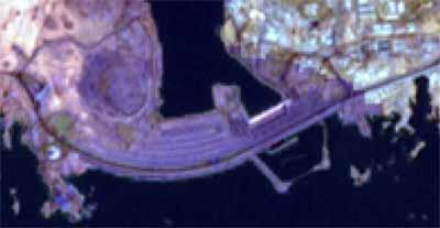
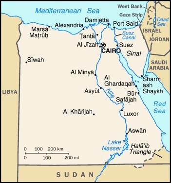
18 /de/afrique/assouan/assouan.html# 18/45

19 19/45
20 Main Issues Nile waters come from rainfall on the Ethiopian highlands (75%) and the catchment areas of the equatorial lakes. The northern part has virtually no rainfall in the summer, while the southern area has heavy rains during the summer months. During the October-May season, both regions are relatively dry due to the presence of the northeast trade winds. The main problem that all countries of the Nile basin face is to ensure the food security of their growing populations. Except for Egypt and Uganda, all the other Nile basin countries had lower per capita food and agricultural production indexes compared to In Rwanda, Sudan, Tanzania and Ethiopia, the food-security situation deteriorated with an average of 17 percent. Access to high-quality water is likely to lead to a conflict in a situation where the availability of freshwater per capita is decreasing rapidly. 20/45

21 partly Ethiopia ~completely partly (scheint ohne Quelle an anderer Stelle entnommen(hurst?)) 21/45
22 Pointing at a map of the Ethiopian highlands, from which 85 percent of the water flowing to Egypt comes via the Blue Nile, Jan Luijendijk, a Dutch water engineer and expert on knowledge systems at the UNESCO_IHE Institute for Water Education at Delft (Netherlands), says, if Ethiopia decided to build a dam on one of these river branches, then that would mean war with Egypt immediately. There is no other choice for Egypt. He says an attempt by any of the nine countries in the Nile basin to use water in a way that would reduce the flow into Egypt could precipitate war. In the 1950s, Egypt took advantage of its status as the regional military and political power to reinforce a colonial era agreement that gvave it almost complete control of the rivers snaking 6,700 kilometres south into the heart of Africa and into the highlands of Ethiopia and Eritrea. In 1959, Egypt signed a complex agreement with the military rulers of newly independent Sudan for the full utilisation of the Nile waters and it meant full! 22/45
23 Ethiopia insists that it has every right to develop its natural resources. It has bitterly reproached Egypt for building the Aswan dam without even consulting it, as well as for appropriating the lion s share of the river resources. An Ethiopian policy paper in 1997 stated, the stark inequality prevailing in the Nile basin cannot remain. The one thing holding back Ethiopia from developing irrigated agriculture on a large scale is the threat of military action, which Egypt would regard as an act of self-defence. When Ethiopia brought in Israeli water engineers in 1989 to survey its water resources, it received a stern warning from Cairo. Ethiopia s claim to use the water arising in its territory has historical and international precedents. During the dispute over water that sprang up between the United States and Mexico at the end of the 19th century, U.S. Attorney General Judson Harmon stated that his country had absolute sovereignty over that part of the Rio Grande river that flowed within its territory and had no obligation to share it. 23/45
24 Background In the early 1900's, a relative shortage of cotton on the world market put pressure on Egypt and the Sudan, then under a British-Egyptian condominium, to turn to this summer crop, requiring perennial irrigation over the traditional flood-fed methods. The need for summer water and flood control drove an intensive period of water development along the Nile, with proponents of Egyptian and Sudanese interests occasionally clashing within the British foreign office over whether the emphasis for development ought to be further up-stream or down. With the end of World War I, it became clear that any regional development plans for the Nile Basin would have to be preceded by some sort of formal agreement on water allocations. In 1920, the Nile Projects Commission was formed, with representatives from India, the United Kingdom, and the United States. The Commission estimated that, of the river's average flow of 84 BCM/yr., Egyptian needs were estimated at 58 BCM/yr. Sudan, it was thought, would be able to meet irrigation needs from the Blue Nile alone. The Nile flow fluctuates greatly, with a standard deviation of about 25%. In recognition of this fact, an appendix was added which suggested that any gain or short-fall from the average be divided evenly between Egypt and Sudan. The Commission's findings were not acted upon. Quelle: 24/45
25 The same year saw publication of the most extensive scheme for comprehensive water development along the Nile, now known as the Century Storage Scheme. The plan, put forth by the British, included: a storage facility on the Uganda-Sudan border a dam at Sennar to irrigate the Gezira region south of Khartoum, and, a dam on the White Nile to hold summer flood water for Egypt. The plan worried some Egyptians, and was criticized by nationalists, because all the major control structures would have been beyond Egyptian territory and authority. Some Egyptians saw the plan as a British means of controlling Egypt in the event of Egyptian independence. Negotiations followed between Egypt and Sudan: The first round of negotiations between Egypt and Sudan took place between September and December 1954, even as Sudan was preparing for its independence, scheduled for The positions of the two sides can be summarized as follows: Quelle: 25/45
26 Egyptian Position Existing needs should take priority. These were described as being 51 BCM for Egypt and four BCM for Sudan, out of an average flow of 80 BCM as measured at Aswan. Any remainder from development projects should be divided as a percentage of each country's population after subtracting 10 BCM for evaporation losses. The respective population and growth rates led to an Egyptian formula for 22/30 of the remainder, or 11 BCM for Egypt, and 8/30, or four BCM for Sudan. There should be one large storage facility, a high dam at Aswan. Total allocations would therefore be 62 BCM for Egypt and 8 BCM for Sudan. Sudanese Position Sudan insisted on using the standard value of 84 BCM for average Nile discharge, and insisted that Egypt's acquired rights were for 48 BCM, not 51 BCM that Egypt claimed. Sudan also suggested that their population was actually 50% larger than Egypt had estimated, and that resulting population-based allocations should be adjusted accordingly, giving Sudan at least one third of any additional water. Storage facilities should be smaller and upstream, as envisioned in the Century Storage Scheme. Consequently, if Egypt insisted on one large project, with comparatively high evaporation losses, these losses should be deducted from Egypt's share. Total allocations, therefore, should be approximately 59 BCM (69 BCM less evaporation) for Egypt and 15 BCM for Sudan. Quelle: 26/45
27 Timeline Nile Projects Commission formed, offers allocation scheme for Nile riparians. Findings were not acted upon. Century Storage Scheme put forward, emphasizing upstream, relatively small-scale projects. Plan is criticized by Egypt New water commission is named. 7 May Sep-Dec Nov 1959 Commission study leads to Nile Waters Agreement between Egypt and Sudan. Aswan High Dam proposed by Egypt. Promise of additional water necessitates new agreement. First round of negotiations between Egypt and Sudan. Negotiations end inconclusively. Sudan gains independence. Egypt is more conciliatory with government after 1958 coup. Agreement for the Full Utilization of the Nile Waters (Nile Waters Treaty) signed between Egypt and Sudan. 27/45
28 Lessons learned Shifting political boundaries can turn intra-national disputes into international conflicts, exacerbating tensions over existing issues. Similar to the Indus, the disappearance of British colonialism turned national issues international, making agreement more difficult. Downstream riparians are not necessarily at a political disadvantage to their upstream neighbors. While in many cases relative riparian positions results in comparable power relationships, with upper riparians having greater hydropolitical maneuverability(turkey on Syria), Egypt's geopolitical strength was able to forestall upstream attempts to sway its position. The individuals or governments involved can make a difference in the pace of the negotiations. Negotiations made little progress between 1954 and 1958, even given Sudan's independence in It was only after pro-egyptian General Ibrahim Abboud took power in a coup in 1958 did negotiations move towards resolution, finally gaining for Sudan water allocations greater than those of their initial bargaining point. 28/45
29 Even Egypt is starting to realize the instability of a situation in which five of the Nile river nations count among the poorest in the world, and in which a large nation subject to repeated droughts is expected to stand by, while the Egyptians and the Sudanese undertake massive irrigation. Egypt is making a big effort to optimise the use of its limited resources by improving the efficiency of irrigation, changing crop patterns, lining irrigation canals and reusing drainage water. Despite all these measures, it still imports about seven million tons of wheat a year. Intermittendly the British and later Egypt wanted to build a canal to cross the Sudd to reduce Evapotranspiration; in the meanwhile this has been realised as costly ecologic nonsense. 29/45
30 Ethiopian Anger (Quelle: BBC NEWS Africa Nile restrictions anger Ethiopia.htm) Egypt's population has more than doubled since the 1960s. But Ethiopia is also facing similar demographic pressures. And Ethiopia's Prime Minister Meles Zenawi says the current division of water use along the river is anything but fair. Irrigation projects have enabled Egypt to turn desert areas into productive land"while Egypt is taking the Nile water to transform the Sahara Desert into something green, we in Ethiopia - who are the source of 85% of that water - are denied the possibility of using it to feed ourselves. And we are being forced to beg for food every year," he says. Mr Meles says he is becoming increasingly angry at Egypt's long running objections to requests from other Nile basin nations to use the river's waters for major irrigation projects. And he warns that his government, along with those of Kenya, Uganda Tanzania - who share the White Nile with Egypt - will no longer be intimidated by past threats, principally by the late President Anwar Sadat, to use force to maintain its grip on the Nile. 30/45
31 The Nile Basin Initiative (NBI) In 1999 six nations of the Great Lakes Burundi, the Democratic Republic of the Congo, Kenya, Rwanda, Tanzania and Uganda as well as Egypt, Sudan and Ethiopia, formed the Nile Basin Initiative. Eritrea joined later. The aim : to resolve peacefully some of the big questions over shared water resources facing these countries. The most compelling issues: Would Egypt be willing to accept a lesser flow of the Nile in favour of economic projects upstream? And would Ethiopia be allowed to use part of the resources of the Blue Nile to develop its own agriculture? Through this Initiative, the Nile nations have embarked on a process that may lead to a revision of the inequitable 1959 agreement that gives nearly all the waters of the Nile to Egypt and, to a lesser extent, to Sudan. 31/45
32 The 10 countries within the Nile River basin will benefit from better access to information on the availability, use and development potential of the Nile resources they share under a new project to improve water management in the region, the United Nations Food and Agriculture Organization (FAO) announced this week. The Nile waters bear tremendous potential as a lever for social and economic development, but at the moment, the inability to jointly plan water development, reach agreement on equitable sharing of benefits and attract investment has delayed the use of this resource for the benefit of the people living in the Nile basin region, FAO s Chief of Water Resources, Development and Management Service Pasquale Steduto said... The $5 million project, funded by the Government of Italy and with FAO assistance, will support basin-wide initiatives to integrate technical data with demographic, socio-economic and environmental information to examine how specific policies and projected water use patterns will affect water resources. It will develop surveys and case studies on the links between water management practices and rural livelihoods and food insecurity. Within this context, a basin-wide survey will be conducted to assess current and potential water use and water productivity in rain-fed and irrigated agriculture. A further case study concerns the analysis and improvement of water productivity through crop management. The project will be carried out under the umbrella of the Nile Basin Initiative, a regional partnership launched by Nile riparian states in 1999 to facilitate the common pursuit of sustainable development and management of the Nile basin, an area of some 3.1 million square kilometres, around 10 per cent of the African continent. Quelle: Europaworld Nile River Basin Countries To Benefit From New Water Management Plan.htm 32/45
Module 1 Educator s Guide: Representative Discussion Points Investigation 3
 Module 1 Educator s Guide: Representative Discussion Points Investigation 3 Ethiopia and Eritrea Our combined population is 59,578,171 people. We have just emerged from a long period of civil war and famine.
Issue Brief A Political Storm Over the Nile
 Issue Brief A Political Storm Over the Nile DECEMBER 2010 This issue brief was prepared by Adonia Ayebare, Director of IPI s Africa Program. Established in 1992, the Africa Program examines the capacity
Exploiting the Nile waters towards a new Nile agreement? Hermen Smit Pieter van der Zaag. Symposium Waterconflicten en waterdiplomatie
 Exploiting the Nile waters 1902-2012 towards a new Nile agreement? Hermen Smit Pieter van der Zaag Symposium Waterconflicten en waterdiplomatie Stichting Nationaal Erfgoed Hotel De Wereld Wageningen, 21
The Nile Basin: Towards Cooperation and A New Legal Regime
 The Nile Basin: Towards Cooperation and A New Legal Regime Karuma Falls S. Salman September 28, 2017 Structure of the Presentation Political Geography of the Nile The Colonial Era Treaties The 1990s Agreements
SS7G1 The student will locate selected features of Africa.
 Standards SS7G1 The student will locate selected features of Africa. a. Locate on a world and regional political-physical map: the Sahara, Sahel, savanna, tropical rain forest, Congo River, Niger River,
RiverWare User Group Conference Boulder, Colorado August 26-27, Kevin Wheeler, P.E.
 RiverWare User Group Conference Boulder, Colorado August 26-27, 2013 Kevin Wheeler, P.E. Acknowledgements Big Thanks to: John Carron Steve Setzer Taylor Adams Edie Zagona Gwen Miller David Neumann Mitch
Conflict on the Nile: The future of transboundary water disputes over the world s longest river
 12 25 November 2013 Conflict on the Nile: The future of transboundary water disputes over the world s longest river Jack Di Nunzio Research Assistant Key Points The Nile River has had a major impact on
AN OUTLINE OF THE NILE BASIN
 The Hydrology of the Nile by J. V. Sutcliffe & Y. P. Parks. IAHS Special Publication no. 5, 1999. CHAPTER 1 AN OUTLINE OF THE NILE BASIN INTRODUCTION The hydrology of the Nile basin cannot be understood
Just how big is Africa?
 The United States China India The United Kingdom Portugal Spain France Belgium Germany The Netherlands Switzerland Italy Eastern Europe Japan 11.7 million sq. miles Just how big is Africa? Chapter 18 Section
PAPER. The Nile From mistrust and sabre rattling to rapprochement. Institute for Security Studies INTRODUCTION NILE WATERS: MAJOR SOURCE OF CONFLICT
 SEPTEMBER 2012 No. 238 Institute for Security Studies PAPER The Nile From mistrust and sabre rattling to rapprochement INTRODUCTION For some time now, the issues of access to and equity in the use of the
Catchment and Lake Research
 LARS 2007 Catchment and Lake Research Multilateral versus bilateral agreements for the establishment of river based organizations: comparison of legal, economic and social benefits in the Zambian experience.
COUNTRY CASE STUDIES: OVERVIEW
 APPENDIX C: COUNTRY CASE STUDIES: OVERVIEW The countries selected as cases for this evaluation include some of the Bank Group s oldest (Brazil and India) and largest clients in terms of both territory
John Groesbeck Ryan Umina Neil Mudjer Dan Armgardt
 John Groesbeck Ryan Umina Neil Mudjer Dan Armgardt Themes Politics Social-Economic Impact Future Damming and Implications Uses of Dams Water Supply Navigation Hydropower Stabilize Water Flow Irrigation
Physical characteristics and biomes:
 Physical characteristics and biomes: Sahel region, bordering Sahara Characteristics Area suffers from lack of rainfall, over grazing, which causes loss of vegetation and loss of inhabitable areas causing
OILS AND FATS IN EAST AFRICA REGION
 OILS AND FATS IN EAST AFRICA REGION ASSESSMENT, TRENDS & OPPORTUNITIES R. Vijayraghavan, CEO East Coast Oils & Fats Limited Tanzania East Africa Africa is the world's second-largest and second-most-populous
Ethiopia s massive new dam threatens Egypt s Nile River
 Ethiopia s massive new dam threatens Egypt s Nile River Ethiopia s massive new dam threatens Egypt s Nile River Internation <img alt= The Grand Ethiopian Renaissance Dam under construction in 2017 (courtesy
Sustainable Land Use. Lund University April 200. By Thor Aasø, Stanley Worgu Marisa Espinosa. Lumes ABSTRACT
 Lumes 999-000 Sustainable Land Use Project : Water scarcity and potential conflict in the Nile River Basin By Thor Aasø, Stanley Worgu Marisa Espinosa ABSTRACT This report analyses the problems surrounding
Chapter 1 Introduction
 Chapter 1 Introduction Nile Basin Water Resources Atlas / 13 14 / Nile Basin Water Resources Atlas Albert Nile just before Murchison Falls Photo: Vivek Bahukhandi The Nile Basin The Nile is the world s
Chapter 20. The Physical Geography of Africa South of the Sahara
 Chapter 20 The Physical Geography of Africa South of the Sahara Chapter Objectives Identify the major landforms, water systems, and natural resources of Africa south of the Sahara. Describe the relationship
UNIT 5 AFRICA PHYSICAL GEOGRAPHY SG 1 - PART II
 UNIT 5 AFRICA PHYSICAL GEOGRAPHY SG 1 - PART II III. CLIMATE & VEGETATION A. The four main climate zones are tropical wet, tropical wet/dry (split into monsoon & savanna), semiarid, and arid. Other climate
Energy Poverty in Africa
 African Energy Commission (AFREC) Paper on Energy Poverty in Africa By Dr. Gilbert NZOBADILA Consultant Energy Policy- AFREC 1 1- Introduction: African background : The African Energy Commission (AFREC)
The Struggle for Control of the Nile. A Water War waiting to come?
 The Struggle for Control of the Nile A Water War waiting to come? by Maxim Worcester There are growing concerns that water shortages and limited or unequal access to water could lead to conflicts between
CIVIL AVIATION & LIBERALISATION THE LATEST CHALLENGES FACING AFRICAN AVIATION AFRAA. 22 February 2017
 CIVIL AVIATION & LIBERALISATION THE LATEST CHALLENGES FACING AFRICAN AVIATION AFRAA 22 February 2017 It is great to be in Kigali, a safe, peaceful and thriving city Rwanda is realizing the enormous potential
International Boundary Study. Tanzania Uganda Boundary
 International Boundary Study No. 55 September 1, 1965 Tanzania Uganda Boundary (Country Codes: TZ-UG) The Geographer Office of the Geographer Bureau of Intelligence and Research INTERNATIONAL BOUNDARY
THE MOST AND LEAST CHILD-FRIENDLY GOVERNMENTS IN AFRICA
 The Most and Least Child-friendly Governments in Africa 5 THE MOST AND LEAST CHILD-FRIENDLY GOVERNMENTS IN AFRICA We must put the best interests of children at the heart of all political and business decision-making,
ICPAC. IGAD Climate Prediction and Applications Centre Monthly Bulletin, February 2017
 IGAD CLIMATE PREDICTION AND APPLICATIONS CENTRE ICPAC Bulletin Issue March 2017 Issue Number: ICPAC/02/299 IGAD Climate Prediction and Applications Centre Monthly Bulletin, February 2017 For referencing
Insights in the water-energy-food nexus in the Nile Basin with the new Eastern Nile Water Simulation Model
 Insights in the water-energy-food nexus in the Nile Basin with the new Eastern Nile Water Simulation Model Wil N.M. van der Krogt, Henk J.M. Ogink For International Conference Sustainability in the WaterEnergy-Food
No UNITED ARAB REPUBLIC and SUDAN Agreement (with annexes) for the full utilization of the Nile waters. Signed at Cairo, on 8 November 1959
 for the full utilization of the Nile waters. Signed at Cairo, on 8 November 1959") UNITED ARAB REPUBLIC and SUDAN Agreement (with annexes) for the full utilization of the Nile waters. Signed at Cairo, on 8 November 1959 Official text: Arabic. Registered by the United Arab Republic on
UNITED ARAB REPUBLIC and SUDAN Agreement (with annexes) for the full utilization of the Nile waters. Signed at Cairo, on 8 November 1959 Official text: Arabic. Registered by the United Arab Republic on
Ancient Egypt: an Overview
 Ancient Egypt: an Overview Timeline Old Kingdom Middle Kingdom 2650 BC 2134 BC 2125 BC 1550 BC New Kingdom 1550 BC 1295 BC http://www.thebanmappingproject.com/resources/timeline.html 1 Three Kingdoms of
All of this week s homework is intended to help you get to know more about the country of Sudan, where Kek is from in Home of the Brave.
 Name: Week 7 Homework All of this week s homework is intended to help you get to know more about the country of Sudan, where Kek is from in Home of the Brave. On the map above, do the following things:
PROMOTING INNOVATION AND TRADE IN HORTICULTURE 25-27th NOVEMBER 2015, KIGALI,RWANDA
 PROMOTING INNOVATION AND TRADE IN HORTICULTURE 25-27th NOVEMBER 2015, KIGALI,RWANDA FACTS AND FIGURES Introduction The Common Market for Eastern and Southern Africa was formed in 1994 as it replaced the
Nile Cooperation beefing up with time!
 Nile Cooperation beefing up with time! Sudan to Benefit from Joining Entebbe Agreement on Nile Gutema Kumsa 07-01-15 The most ancient civilizations developed on the banks of the River in Egypt, Sudan,
A: Pre-reading Vocabulary
 - 1 - In this text you are going to read about Egypt and the Egyptian people. There are some words in this text that you won t see very often when you are reading but are important for this text. These
UNIT 5 PHYSICAL GEOGRAPHY SG 1 - PART I
 UNIT 5 PHYSICAL GEOGRAPHY SG 1 - PART I Africa is HUGE! I. LANDFORMS A. Plateaus - an area of relatively level high ground. 1. Africa s interior is dominated by series of plateaus and elevated basins such
Regional Investment rules in Eastern and Southern Africa
 Regional Investment rules in Eastern and Southern Africa : COMESA Common Investment Area (CCIA) towards the Tripartite COMESA-EAC-SADC and Pan African investment arrangements London, 14 September 2012
Population (million) % of Africa
 % of Africa") FAO. Irrigation in in figures: AQUASTAT Survey 2005 TABLE 1 al distribution of cultivable and cultivated areas Cultivable areas Cultivated areas in 2002 In cultivable areas (ha) (ha) (%) Northern 65 320
FAO. Irrigation in in figures: AQUASTAT Survey 2005 TABLE 1 al distribution of cultivable and cultivated areas Cultivable areas Cultivated areas in 2002 In cultivable areas (ha) (ha) (%) Northern 65 320
A Hydro-diplomacy in Northeastern Africa: A Trajectory for Regional Integration +
 A Hydro-diplomacy in Northeastern Africa: A Trajectory for Regional Integration + By Yacob Arsano, AAU A Keynote Lecture for Summer Class of 2016 at the University of Bergen 14 June 2016 Abstract Northeastern
Key Indicators for South Sudan
 Key Indicators for South Sudan National Bureau of Statistics Fast Facts Total Population of South Sudan is 8.26 million Total Area of South Sudan is 644,329 sq. km More than half (51%) of the population
INFRASTRUCTURE DEVELOPMENT IN TANZANIA
 INFRASTRUCTURE DEVELOPMENT IN TANZANIA PROF JOSEPH MSAMBICHAKA MBEYA UNIVERSITY OF SCIENCE AND TECHNOLOGY 50 TH YEARS ERB ANNIVERSARY 5 TH TO 7 TH SEPTEMBER 2018 PRESENTATION LAYOUT 1. DEFINITION OF INFRASTRUCTURE
Integrated Water Resource Management Policy in Africa: Case Study of the Nile Water and Its Politics
 S Open Access Journal of Geology and Geoscience Case Report Integrated Water Resource Management Policy in Africa: Case Study of the Nile Water and Its Politics Mamadou L Bah 1, Zakaria Dit Zan Sangare
SYNTHESIS REPORT. Integrated Nile Basin
 SYNTHESIS REPORT Integrated Nile Basin Contact person: V Jonker Aurecon Centre 1 Century City Drive Waterford Precinct Century City, Cape Town, RSA +27 21 526 9400 Verno.Jonker@aurecongroup.com Submitted
OPENING REMARKS BY H.E
 OPENING REMARKS BY H.E. JAKAYA MRISHO KIKWETE, PRESIDENT OF THE UNITED REPUBLIC OF TANZANIA AT THE PRESIDENTIAL ECONOMIC COMMISSION MEETING BETWEEN UNITED REPUBLIC OF TANZANIA AND THE REPUBLIC OF SOUTH
AFRICAN PHYSICAL GEOGRAPHY
 AFRICAN PHYSICAL GEOGRAPHY Here are some factoids about Africa: world s second largest continent (11,700,000 miles). Home to 52 countries, 1,000 languages, 800 million people. 10% of the world s population
July 2014 Volume 6. Figure 1: Main Staple Food Commodities Informally Traded Across Selected Borders in Eastern Africa Between January and June 2014
 July 2014 Volume 6 Figure 1: Main Staple Food Commodities Informally Traded Across Selected Borders in Eastern Africa Between January and June 2014 The Market Analysis Sub-group of the Food Security and
PM MODI S 3 NATION AFRICAN TOUR
 PM MODI S 3 NATION AFRICAN TOUR Rwanda Uganda South Africa It was first visit by Indian Prime Minister to Uganada in over 20 years. PM Modi also delivered keynote address at Ugandan Parliament, making
Wondwosen Michago Seide, Water Resources Consultant, Intergovernmental Authority of Development
 Wondwosen Michago Seide, Water Resources Consultant, Intergovernmental Authority of Development Construction of the Grand Ethiopian Renaissance Dam Wondwosen Seide The Nile River is the only shared physical
Gambia vs Ethiopia Gambia Ethiopia. Wednesday, March 21, 12
 Gambia vs Ethiopia Gambia Ethiopia Climate Change Gambia s normal climate is subtropical. Slightly dry and rainy. But recently there has been climate change and the country s capital is said to be completely
Project Titled: Dr. John Garang Green City
 Project Titled: Dr. John Garang Green City Submitted to National Government of Republic of South Sudan, South Sudanese s Friends such as African Development Bank, USAID, the World Bank, Norfund, that s
Annex III: Statistics
 Annex III: Statistics Table A.3.1 Physical characteristics of Arab countries Country Area, 2011 (thousand square kilometres) Length of coast, 2005 (kilometres) Rainfall, 2002 (millimetres per year) Total
Chapter 13 and 14 Geography Study Guide
 Chapter 13 and 14 Geography Study Guide Multiple Choice Identify the letter of the choice that best completes the statement or answers the question. 1. Which West African country has the largest population
TABLE OF CONTENTS COUNTRY FOCUS: ALGERIA
 Africa Statistics Flash Selected Socio-Economic Indicators on Africa May 218 TABLE OF CONTENTS COUNTRY FOCUS: ALGERIA ---------------------------------------------------------------------------------------------
Egypt and the Nile Basin
 Aquat. Sci. 67 (2005) 42 50 1015-1621/05/010042-09 DOI 10.1007/s00027-004-0765-y EAWAG, Dübendorf, 2005 Aquatic Sciences Special Feature Article Egypt and the Nile Basin Magdy Hefny 1, * and Salah El-Din
Ancient Egypt. Life Along the Nile River
 Ancient Egypt Life Along the Nile River 2018 Geography How Does Geography affect the way that people live? Geography- Where in the World? You are Here Streetsboro, Ohio United States of America Geography-
MULTILATERALISM AND REGIONALISM: THE NEW INTERFACE. Chapter XI: Regional Cooperation Agreement and Competition Policy - the Case of Andean Community
 UNCTAD/DITC/TNCD/2004/7 UNITED NATIONS CONFERENCE ON TRADE AND DEVELOPMENT Geneva MULTILATERALISM AND REGIONALISM: THE NEW INTERFACE Chapter XI: Regional Cooperation Agreement and Competition Policy -
Unit 9 The Middle East SG 1 - Physical Geography, Population & Demographics
 Unit 9 The Middle East SG 1 - Physical Geography, Population & Demographics I. Physical Geography A. The Middle East includes southwestern Asia and North Africa. 1. The name is Eurocentric. Middle East
Hydrological study for the operation of Aposelemis reservoir Extended abstract
 Hydrological study for the operation of Aposelemis Extended abstract Scope and contents of the study The scope of the study was the analytic and systematic approach of the Aposelemis operation, based on
Network of International Business Schools
 Network of International Business Schools WORLDWIDE CASE COMPETITION Sample Case Analysis #1 Qualification Round submission from the 2015 NIBS Worldwide Case Competition, Ottawa, Canada Case: Ethiopian
Estimating the potential impacts of further liberalisation of the EU-Africa aviation market on African airports
 Estimating the potential impacts of further liberalisation of the EU-Africa aviation market on African airports Eric Tchouamou Njoya University of Huddersfield Panayotis Christidis European Commission
HCPI COMESA Monthly News Release
 HCPI COMESA Monthly News Release Is sue No. 84 March 2018 Common Market for Eastern and Southern Africa (COMESA) Macroeconomic Indicators COMESA region annual inflation rate stood at 19.4% in March 2018
Salman M.A. Salman a a International Water Resources Association
 This article was downloaded by: [Salman M.A. Salman] On: 11 February 2013, At: 04:42 Publisher: Routledge Informa Ltd Registered in England and Wales Registered Number: 1072954 Registered office: Mortimer
STUDY GUIDE. The Land. Chapter 20, Section 1. The Land of Africa South of the Sahara. Landforms Water Systems Natural Resources.
 For use with textbook pages 499 504. The Land Terms to Know escarpment A steep, often jagged slope or cliff (page 500) cataract A towering waterfall (page 500) rift valley A large crack in the earth s
Benefit of Grand Ethiopian Renaissance Dam Project (GERDP) for Sudan and Egypt
 for Sudan and Egypt") EIPSA Communicating Article Energy, Water, Environment & Economic Volume 1; Issue 1; Dec 2013, Pages 1-12 Benefit of Grand Ethiopian Renaissance Dam Project (GERDP) for Sudan and Egypt Belachew Chekene
EIPSA Communicating Article Energy, Water, Environment & Economic Volume 1; Issue 1; Dec 2013, Pages 1-12 Benefit of Grand Ethiopian Renaissance Dam Project (GERDP) for Sudan and Egypt Belachew Chekene
East Africa Crossborder Trade Bulletin April 2011
 East Africa Crossborder Trade Bulletin April 2011 The Market Analysis Sub-group of the Food Security and Nutrition Working Group (FSNWG) monitors cross-border trade of 88 food commodities and livestock
A Brief Overview of the Rio Grande Compact 04/26/06
 A Brief Overview of the Rio Grande Compact 04/26/06 The New Mexico Interstate Stream Commission Investigate, Protect, Conserve, and Develop the State s Waters and Stream Systems Negotiate and Administer
Southern Africa outpaces North Africa in governance performance
 Monday 5 th October 2009 Southern Africa outpaces North Africa in governance performance 2009 Ibrahim Index of African Governance shows that half of Africa s ten best performing countries are in Southern
Benefits of Integrating into a Regional Power Pool
 EASTERN AFRICA POWER POOL Benefits of Integrating into a Regional Power Pool Ephrem Tesfaye Power Economist Eastern Africa Power Pool (EAPP) ETHIOPIA The Eastern African Power Pool (EAPP) The Energy Ministers
Areas in which anti personnel mines are known or suspected to be implaced
 Algeria: Areas in which Anti personnel mines are known or suspected to be implaced. Mines areas inherited from the colonial period are located on Algeria s eastern with Tunisia and Western border with
EASTERN AFROMONTANE 1,043,191 km 2
 Egypt Saudi Arabia Oman EASTERN AFROMONTANE 1,043,191 km 2 Sudan Asmara Eritrea Yemen Djibouti Addis Ababa South Sudan Ethiopia BIODIVERSITY TARGET 2020 TARGET: 17% protected Democratic Republic of the
Welcome to AVI AFRIQUE 2017
 Welcome to AVI AFRIQUE 2017 Single African sky and Functional Airspace Blocks: Improving Air Traffic Management The global ATM operational concept is fundamental framework drive ATM operational requirements,
Regional outlook Sub-Saharan Africa 24/11/2015. Share commodities in good exports. Share commodities in goods imports
 Table 1: Economic structure indicators Number of Inhabitants (m.) Size of the economy (in USD bn.) Size of the economy (% of world GDP) Share commodities in good exports Share commodities in goods imports
Introduction to Africa
 Introduction to Africa Did you know? Africa has more countries than any other continent. The Sahara is a desert that is the size of the U.S. It s the world's largest desert. Most of the world s gold and
Africa the potential for growth
 Africa the potential for growth Ian Taylor President & CEO, Vitol March 2015 The oil price a long term view 2010 to date - $94 2000s - $49.6 1980s - $25.8 1990s - $18.3 1970s $10.5 1 Q1-14 Q2-14 Q3-14
Meeting of Energy Regulators for the Launch of the Association of Energy Regulators for Eastern and Southern Africa
 Distr. LIMITED CS/ID/RAERESA/II/5 March 2009 Original: ENGLISH COMMON MARKET FOR EASTERN AND SOUTHERN AFRICA Meeting of Energy Regulators for the Launch of the Association of Energy Regulators for Eastern
Africa s. Presentation, Graphic Organizers, & Activities
 Africa s Presentation, Graphic Organizers, & Activities STANDARDS: SS7G1 Locate selected features of Africa. a. Locate on a world and regional political-physical map: Sahara, Sahel, savanna, tropical rain
Nile by 2050: the case of Ethiopia, Sudan and Egypt Part II: Nile water utilization and the ensuing demand of Ethiopia
 Nile by 2050: the case of Ethiopia, Sudan and Egypt Part II: Nile water utilization and the ensuing demand of Ethiopia Habtamu Abay, abay_habtamu@yahoo.com, Addis Ababa, Ethiopia, July 8, 2013 Part I of
Table of CONTENTS. COUNTRY FOCUS: United Republic of Tanzania
 Africa Statistics Flash Selected Socio-Economic Indicators on Africa December 216 Table of CONTENTS COUNTRY FOCUS: United Republic of Tanzania ------------------------------------------------------------
Table of CONTENTS. COUNTRY FOCUS: Tunisia
 Africa Statistics Flash Selected Socio-Economic Indicators on Africa October 217 Table of CONTENTS COUNTRY FOCUS: Tunisia ----------------------------------------------------------------------------------------------
North Africa. Chapter 25. Chapter 25, Section
 Chapter 25, Section World Geography Chapter 25 North Africa Copyright 2003 by Pearson Education, Inc., publishing as Prentice Hall, Upper Saddle River, NJ. All rights reserved. Chapter 25, Section World
COMESA VACANCIES OFFICE OF THE SECRETARY GENERAL
 COMESA VACANCIES OFFICE OF THE SECRETARY GENERAL VACANCY NOTICE I. EXECUTIVE SECRETARY OF COMESA CLEARING HOUSE II. DIRECTOR OF COMESA MONETARY INSTITUTE Background The Common Market for Eastern and Southern
Table of CONTENTS. COUNTRY FOCUS: Equatorial Guinea
 Africa Statistics Flash Selected Socio-Economic Indicators on Africa August 217 Table of CONTENTS COUNTRY FOCUS: Equatorial Guinea ---------------------------------------------------------------------------
Promoting Tourism as an Engine of Inclusive Growth and Sustainable Growth in Africa. Egyptian Minister of Tourism YEHIA RASHED
 Promoting Tourism as an Engine of Inclusive Growth and Sustainable Growth in Africa Egyptian Minister of Tourism YEHIA RASHED JULY 21, 2016 International tourism highlights (2015): Introduction: Tourism
TABLE OF CONTENTS COUNTRY FOCUS: BENIN
 Africa Statistics Flash Selected Socio-Economic Indicators on Africa March 218 TABLE OF CONTENTS COUNTRY FOCUS: BENIN ------------------------------------------------------------------------------------------------
THE AFRICAN DEVELOPMENT BANK GROUP. At the centre of Africa s transformation
 THE AFRICAN DEVELOPMENT BANK GROUP At the centre of Africa s transformation African Development Bank Group At the centre of Africa s transformation The African Development Bank Group is a multilateral
World History: Societies of the Past
 World History: Societies of the Past 1. What is history? History is the story of people from the past to present. It is when people study what happened in the past related with someone or something. History
SUB-SAHARAN AFRICA (2): POPULATION AND SETTLEMENT GEOGRAPHY
: POPULATION AND SETTLEMENT GEOGRAPHY") SUB-SAHARAN AFRICA (2): POPULATION AND SETTLEMENT GEOGRAPHY 1. Introduction 2. Demographics: population growth and AIDS 3. Rural settlement patterns 4. Urban structures 5. Globalization and Africa: the
SUB-SAHARAN AFRICA (2): POPULATION AND SETTLEMENT GEOGRAPHY 1. Introduction 2. Demographics: population growth and AIDS 3. Rural settlement patterns 4. Urban structures 5. Globalization and Africa: the
THE GEOPOLITICS OF WATER NEGOTIATIONS SUCCEEDING THE GERD PROJECT IN THE NILE RIVER BASIN: THE CASE OF ETHIOPIA, EGYPT, AND SUDAN
 THE GEOPOLITICS OF WATER NEGOTIATIONS SUCCEEDING THE GERD PROJECT IN THE NILE RIVER BASIN: THE CASE OF ETHIOPIA, EGYPT, AND SUDAN Anwar Hassen Tsega February 2017 Introduction Water politics has come to
NATIONAL SENIOR CERTIFICATE NATIONAL GRADE 12
 NATIONAL SENIOR CERTIFICATE NATIONAL GRADE 12 GEOGRAPHY P1 FEBRUARY/MARCH 2013 ANNEXURE This annexure consists of 12 pages. Geography/P1 2 DBE/Feb. Mar. 2013 FIGURE 1.1: GLOBAL PRESSURE BELTS AND WINDS
One Commodity Map. 7. What is a commodity? 8. Explain what a one-commodity country is.
 7. What is a commodity? 8. Explain what a one-commodity country is. 9. What must African countries do in order to become more stable economically? One Commodity Map Countries which OIL is the lone commodity
WHO Regional Committee for the Eastern Mediterranean Sixty-fifth session, Khartoum, Sudan October Information bulletin 1
 WHO Regional Committee for the Eastern Mediterranean Sixty-fifth session, Khartoum, Sudan 15 18 October 2018 Information bulletin 1 1 Introduction Provinces Sudan has a federal government structure with
2009 Carole Marsh/Gallopade International
 Live Work Play Learn LIVE LEARN WORK TM PLAY 2009 Carole Marsh/Gallopade International Permission is hereby granted to the individual purchaser or classroom teacher to reproduce materials in this book
Chapters 14 and 15 Geography Study Guide
 Chapters 14 and 15 Geography Study Guide Multiple Choice Identify the letter of the choice that best completes the statement or answers the question. 1. Gorillas live within dense rain forests of. a. Rwanda
Rivers. Highlights of some of the World s Most Famous Rivers!
 Rivers Highlights of some of the World s Most Famous Rivers! Directions This Power Point presentation contains information about some of the most famous rivers in the world! Students should use this presentation
Grade 5 Geography Term 1
 1 Grade 5 Geography Term 1 Contents Section 1: World map and compass directions... 2 The position of the equator and the North and South Poles on a globe... 2 The seven continents of the world... 3 The
How to play. The center aisle divides our class into 2 teams. Team members are NOT allowed to help their teammate when they are asked a question.
 Floaters & Sinkers How to play The center aisle divides our class into 2 teams. Each person will be responsible for answering a question for every round played. Team members are NOT allowed to help their
SHARE Toolkit: Case Studies. Integrated management of the Senegal River. IUCN Water Programme. By Madiodio Niasse. 1. Origin and Background
 IUCN Water Programme SHARE Toolkit: Case Studies Integrated management of the Senegal River By Madiodio Niasse 1. Origin and Background The Senegal River is 1,800 kilometres long. It originates from the
IPAR 4 TH ANNUAL RESEARCH CONFERENCE Kigali 28 th -29 th January Prof Herman Musahara OSSREA
 IPAR 4 TH ANNUAL RESEARCH CONFERENCE Kigali 28 th -29 th January 2015 MDGs, Inclusive and Sustainable Development today and after 2015. Reflections on Eastern and Southern African countries and role of
STATUS OF THE COMESA SEED HARMONISATION PROGRAMME (COMSHIP) John Mukuka, COMESA Seed Development Expert. June, 2018
 John Mukuka, COMESA Seed Development Expert. June, 2018") STATUS OF THE COMESA SEED HARMONISATION PROGRAMME (COMSHIP) John Mukuka, COMESA Seed Development Expert. June, 2018 COMESA COVERAGE Size: 11.6 Million sq. km Population: 510 million (2018) GDP: $950 billion
STATUS OF THE COMESA SEED HARMONISATION PROGRAMME (COMSHIP) John Mukuka, COMESA Seed Development Expert. June, 2018 COMESA COVERAGE Size: 11.6 Million sq. km Population: 510 million (2018) GDP: $950 billion
UGANDA S URBAN DEVELOPMENT; A SCRUTINY OF TRANSPORT PLANNING AND MOBILITY IN TOWNS AND CITIES
 UGANDA S URBAN DEVELOPMENT; A SCRUTINY OF TRANSPORT PLANNING AND MOBILITY IN TOWNS AND CITIES BY Mutabazi Sam Stewart Executive Director Uganda Road Sector Support Initiative (URSSI) P.O Box 11110 Kampala,
182ND SESSION OF THE COUNCIL
 International Civil Aviation Organization FI-WP/675 19/11/07 WORKING PAPER 182ND SESSION OF THE COUNCIL FINANCE COMMITTEE Subject No. 3 Financial matters for consideration and approval by the Finance Committee
7/27/2010. Regions of Subsaharan Africa. SUBSAHARAN AFRICA II (Chapter 6, pages ) Southern Africa. South Africa: Peaceful Change from Apartheid
 Southern Africa. South Africa: Peaceful Change from Apartheid") SUBSAHARAN AFRICA II (Chapter 6, pages 209-227) Regions of Subsaharan Africa Southern Africa 10 countries, 6 of them landlocked Congo Basin marks northern limit Plateau country Rich in natural resources
SUBSAHARAN AFRICA II (Chapter 6, pages 209-227) Regions of Subsaharan Africa Southern Africa 10 countries, 6 of them landlocked Congo Basin marks northern limit Plateau country Rich in natural resources