BEACON LINE RAIL TRAIL BREWSTER TO HOPEWELL JUNCTION
|
|
|
- Gwenda Smith
- 5 years ago
- Views:
Transcription


1 BEACON LINE RAIL TRAIL BREWSTER TO HOPEWELL JUNCTION OCTOBER 2017 DRAFT CONCEPT PLAN
2 Page left intentionally blank


3 TABLE OF CONTENTS EXECUTIVE SUMMARY Executive Summary...i CHAPTER 01: INTRODUCTION Introduction...2 Trail Benefits...3 Study Area Overview...5 Summary of Previous Plans and Initiatives...7 Maybrook Trailway...7 Opportunities & Challenges...9 CHAPTER 02: PROPOSED TRAIL ROUTE Introduction Trail Details...13 Track Alignment...13 Cross-Sections...17 Undergrade Open Deck Bridges Undergrade Culverts...25 Overhead Bridges...26 Trailheads On-Road Recommendations At-Grade Road Crossing Recommendations Drainage...29 Proposed Trail Route...31 Section CHAPTER 03: ACTION PLAN Next Steps Public Outreach Public Workshops Stakeholder Meetings Environmental Review and Permitting Requirements State Environmental Quality Review (SEQR) Compliance Prior SEQR Review 2010 Statewide Trails Plan National Environmental Policy Act (NEPA) Compliance Action Plan for SEQR and NEPA Compliance Permits MAPS Proposed Trail Route... iv Study Area Overview Map...6 Existing Track Location within ROW Map...14 Existing Track Alignment and Proposed Track Crossings Map Section 1: Proposed Trail Route Map Section 2: Proposed Trail Route Map Section 3: Proposed Trail Route Map Section 4: Proposed Trail Route Map Section 5: Proposed Trail Route Map Section Section Section Section Cost Estimate...41

4 EXECUTIVE SUMMARY The purpose of this study is to assess the feasibility of constructing a shared-use path along Metro-North Railroad (MNR) Beacon Line Corridor from Brewster, NY to Hopewell Junction, NY. This project is a key part of the Empire State Trail - connecting a significant gap in the Hudson Valley Greenway Trail between the Putnam Trailway and the Dutchess Rail Trail and Walkway Over the Hudson State Park. The trail corridor runs through a beautiful section of the Hudson Valley, with long stretches through rural landscapes and wooded areas featuring seasonal waterfalls, rock cuts and a crossing of the Appalachian Trail along the way. The trail corridor provides for a continuous, level shareduse path that will be accessible to people of all ages and abilities, including walking, bicycling, wheelchairs and other uses. The Beacon Line does not currently have active train traffic. The full corridor is 34 miles long (Brewster, NY to Beacon, NY), but the focus of this study is to provide a rail with trail on the Brewster to Hopewell Junction portion. The proposed Beacon Line Rail Trail crosses through two counties (Putnam and Dutchess) and five towns (Southeast, Patterson, Pawling, Beekman, and East Fishkill). Rail Corridor West of S. Greenhaven Road - Beekman i


5 An existing conditions inventory for the Beacon Line Rail Trail was taken to document the following attributes along the corridor: Location of the single track (north, centered, or south) Undergrade bridges Undergrade culverts Overhead bridges At-grade roadway crossings Trailheads and access points Challenges to trail development The design of the trail will also have to consider MNR s underground fiber optic line and ensure that the final design of the trail does not impact operation of or maintenance to the line and its structures. The existing conditions inventory was a key element in determining the conceptual alignment of the Beacon Line Rail Trail. Once complete the trail will provide considerable benefits to the region, attracting visitors to the scenic landscapes and community centers dotting the corridor. The legacy of the railway including its associated infrastructure, surrounding environment, and adjacent land use present a host of variables and challenges to construction. The following highlights some of those opportunities and challenges: Connecting recreational opportunities Scenic and tranquil surroundings Tracks cannot be removed from the corridor Single-track bridges along the corridor Narrow right-of-way due to rock cuts or overhead bridges Tracks down the center of the corridor in some locations Existing infrastructure The preferred alignment for the Beacon Line Rail Trail primarily follows the alignment of the Beacon Line from Brewster, NY to Hopewell Junction, NY. Rail Corridor and existing chain link fence near Route Patterson Rail Corridor West of S. Route Pawling ii
6 Executive Summary BEACON LINE RAIL TRAIL CONCEPT PLAN The proposed shared-use path begins at the northern end of the Maybrook Trailway, at Tonetta Road in Brewster, and ends at the southern end of the Hopewell Rail Yard in Hopewell, Junction. The Beacon Line Rail Trail will travel through the Hopewell Rail Yard, connecting to the Dutchess Rail Trail beneath Route 82. In addition, the project will create a connection between the Putnam Trailway and the Maybrook Trailway using Route 6 and Main Street. The trail will comprise a total of 23.5 miles of off-road routes and 0.7 miles of on-road routes. The preliminary assessment of the trail alignment identified several areas where the existing track may conflict with the trail. To overcome this challenge, the Plan recommends extending the trail outside the rail bed (but still within the railroad right-of-way) to reach the crossing point, This alternative approach will also require creating a new track crossing where none currently exists in one location. The various types and widths of rights-of-way along the Beacon Rail Line require multiple crosssections. These include two preferred options, a reduced option for more narrow rights-of-way, as well as three special case options for undergrade bridges, undergrade culverts, and overhead bridges. There are ten existing undergrade bridges along the rail alignment that will require improvements to complete the trail. For the most part, the structural elements of these bridges (abutments and main carrying beams) are intact and serviceable based on field observations by structural engineers. The design intent is to utilize the existing structures to provide a functional, efficient, and cost effective solution to allow for reestablishing crossings along the rail trail corridor. The existing structure of the rail bridges will be assessed and the proposed work will consist of the construction of timber decking and wood or metal railings on top of the existing rail structures. There are multiple undergrade culverts along the corridor which provide passage for cattle, drainage, and streams. The undergrade culverts in almost all instances take one of two forms: A pipe or culvert section, typically steel or concrete; A short-span bridge, constructed using rail sections across two concrete or stone walls, with concrete cast over the top of the rail sections. For protection of trail users, safety fencing should be provided above the undergrade culverts. There are several roads that pass over the Beacon Line along the length of the trail project. These carry major highways and state, county, and local roads. The primary impact of these overhead bridges will be constraints on trail width due to clear space available between the bents or abutment walls supporting the bridges. Five trailheads and two gateways are recommended to provide users a place to easily access the trail. These trailheads can include parking areas, wayfinding signage, and various amenities such as bike repair stations, benches, picnic tables, bike racks, trash, and receptacles. iii *See section maps for locations of trailheads, undergrade bridges, undergrade culverts, overhead bridges, at-grade road crossings, and on-road routes.
7 LA GRANGE Tymor Park UNION VALE 55 DOVER WAPPINGER BEEKMAN PARKWAY Sylvan DUTCHESS RAIL TRAIL Hopewell Junction STATE TACONIC 216 PAWLING 22 EAST FISHKILL Village of Pawling Whaley 55 APPALACHIAN TRAIL MAP DUTCHESS COUNTY PUTNAM COUNTY White Pond HERE Wonder State Park PATTERSON KENT Clarence Fahnestock Memorial State Park TACONIC STATE Nimham Mountain Putnam County Park Carmel 22 PARKWAY BEACON LINE RAIL TRAIL: PROPOSED TRAIL ROUTE West Branch PUTNAM TRAILWAY Bog Brook PUTNAM VALLEY Proposed Trail Route Endpoints Existing Shared-Use Path Proposed Shared-Use Path Proposed On-Road Routes Miles N CARMEL 6 6 Village of Brewster 6 SOUTHEAST East Branch iv LB 202 iv
8 Executive Summary BEACON LINE RAIL TRAIL CONCEPT PLAN Drainage of the trail will be handled primarily by sheet flow off the path surface and into the existing drain system for the railroad. Given the existing conditions, it is assumed that the trail will not significantly increase the amount of impermeable surface in the corridor, and so there should be sufficient capacity within the system to accept the additional runoff. Sections where the railbed is currently not draining well will require improvements, such as swales or stormwater piping, to correct the drainage flow and accept the additional runoff. The proposed trail alignment primarily follows the existing track alignment. If necessary, there are short on-road segments recommended in the southern and northern sections of the trail connecting to the Putnam Trailway and Dutchess Rail Trail, respectively. Facility recommendations for each on-road route and at-grade crossing were determined using the On-Road Bicycle Facility Selection and EST Crossing Treatment Selection tables included in the Empire State Trail Design Guide. These tables consider roadway characteristics such as the functional classification, speed limit, AADT, and number of lanes of each roadway to determine appropriate on-road facilities and crossings. Safe crossing recommendations are provided at all atgrade crossings along the shared-use path. There are a total of 0.7 miles of on-road facilities and 14 at-grade crossings along the Beacon Line Rail Trail conceptual alignment. A concept phase estimate budget cost has been prepared for the project. Basic trail construction costs were assumed for the shared-use path portion of the Beacon Line Rail Trail. Included in these costs were: Construction of a new superstructure, where missing; Trail amenities such as trailheads, site furniture, wayfinding signage, fencing, and other improvements; Drainage and utility work; Improvements at road crossings; and The on-road segments of the trail. The estimate also includes a number of multipliers to reflect the hard and soft costs of the total project as follows: Escalation on Construction: 5% per year for two years Engineering and Survey: 15% General Contingency: 25% The total cost for the project, including the above multipliers, is currently estimated between $38 and $43 million. v

9 Following completion of the Concept Plan, the development of a public involvement process will be a high priority for the next phase of work. This process will involve two different tracks of meetings: Public Workshops Stakeholder Meetings A proposed schedule for design and construction of the Beacon Trail is as follows: Preliminary design: November July 2018 Design/Build procurement and permitting: August January 2019 Design/Build (final design and construction: February December 2020 Final acceptance and contract close-out: January April 2021 Dutchess Rail Trail - East Fishkill vi
10 01 INTRODUCTION

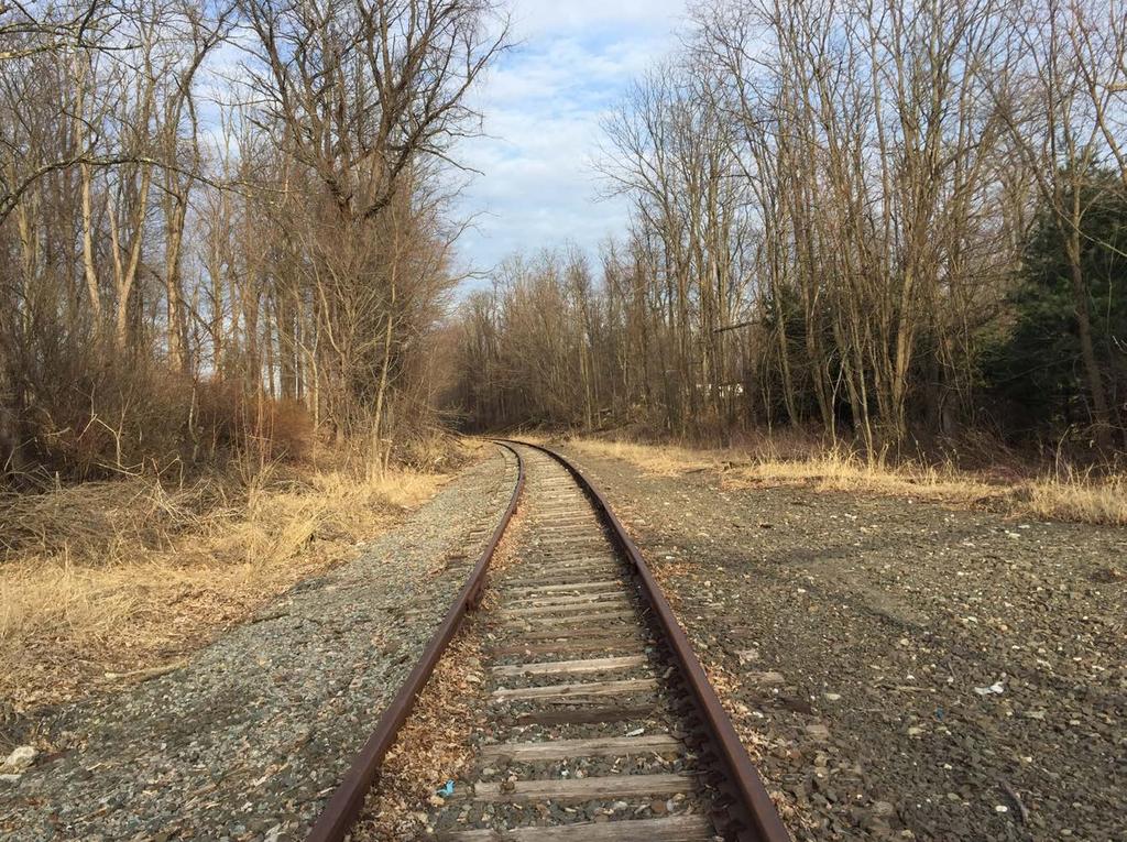
11 INTRODUCTION The purpose of this Concept Plan is to guide development of a shared-use path along the Metro-North Railroad (MNR) Beacon Railroad Line corridor from Brewster, NY to Hopewell Junction, NY. This project is a key part of the Empire State Trail - connecting a significant gap in the Hudson Valley Greenway Trail between the Putnam Line Rail Trail and the Dutchess Rail Trail and Walkway Over the Hudson State Park. When completed, this section of the EST will connect from New York City to New Paltz. The report provides a detailed concept and typical sections for MNR to use in their detailed design of the project. The majority of existing undergrade bridges along the corridor are intact and were designed to carry two rail lines, providing an opportunity for adaptive re-use of the structures for the trail. The rail with trail is planned assuming the railroad tracks need to remain intact for the length of the corridor. The trail corridor runs through a beautiful section of the Hudson Valley landscape, with long stretches through wooded areas featuring seasonal waterfalls, rock cuts and a crossing of the Appalachian Trail along the way. There are opportunities to tell the story of the railroad and the region s history on the trail, and trailhead locations are identified. The trail corridor provides for a continuous, level shared use path that will be accessible to people of all ages and abilities, including walking, bicycling, wheelchairs and other uses. The Beacon Line does not currently have active train traffic. The railroad tracks must remain along the line for potential future use. The full corridor is 34 miles long (Brewster, NY to Beacon, NY), but the focus of this study is to provide a rail with trail on the Brewster to Hopewell Junction portion of the corridor to complete the gap in the Hudson River Valley Greenway Trail. Rail corridor and exsiting chain link fence beneath I- - Southeast 2
12 Introduction BEACON LINE RAIL TRAIL CONCEPT PLAN TRAIL BENEFITS HEALTH AND WELL-BEING The Beacon Line Rail Trail will improve the health and well-being of residents and visitors to the Hudson Valley, as access to outdoor activities increases participation in healthy lifestyles and improves the academic performance of children. Regular exercise reduces the likelihood of heart and respiratory disease. People with access to trails exercise more regularly than those without access to similar recreational opportunities. TRANSPORTATION Trails provide alternatives for getting around for people without access to cars or transit as well as for those wanting to choose a healthier transportation alternative. Construction of the Beacon Line Rail Trail will increase mobility and accessibility by providing a new recreational opportunity. SAFETY Trails provide safer recreational opportunities for all users. They provide a designated space for bicyclists and pedestrians and minimize interactions with motor vehicle traffic. This is especially important for the children in the region. ECONOMIC The positive economic impacts of trails include recreation-based tourism, an increase in property values, an enhanced ability to attract new employers and employees, and development of new industries, such as visitor services and outdoor related product sales, to accommodate the increase in recreational opportunities in the area. EDUCATION Not only do trails provide outdoor learning opportunities, but children with access to open space resources demonstrate higher academic achievement, better attendance, and higher levels of concentration. They also provide children with the opportunity to discover local natural and cultural heritage. ENVIRONMENT Trails benefit the environment as well as the people they serve. Trails provide opportunities for habitat protection and enhancement, stormwater and flood retention, improved water and air quality, conservation of natural and cultural resources, and scenic views. CIVIC ENGAGEMENT Greenways provide opportunities for diverse groups of people to discover common interests and form a sense of community. Whether as a means of improving quality of life, our health, our children s well-being or our natural places, civic leadership springs from community engagement. When neighbors are engaged, employers are enthused, and visitors are attracted, the vitality of a community is boosted. 3
13 Page left intentionally blank 4
14 Introduction BEACON LINE RAIL TRAIL FEASIBILITY STUDY STUDY AREA OVERVIEW The Beacon Line Rail Trail crosses through two counties (Putnam and Dutchess) and five towns (Southeast, Patterson, Pawling, Beekman, and East Fishkill). For the most of its length, the corridor is wooded and rural in character, providing a unique trail experience within a day s travel from the New York metro region. The trail is located only a few miles north and east of I-, and crosses the Taconic State Parkway at its northern end. There is MNR station access nearby at Poughkeepsie and in Brewster, providing multi-modal access to transit along the trail. At the southern end, the Beacon Line will connect to the Putnam Trailway. This connection will continue south via the Westchester County trail system to New York City. At the northern end in Hopewell Junction, the trail will link with the Dutchess Rail Trail and the Walkway Over the Hudson Bridge. Counties Putnam County Dutchess County Towns Southeast Patterson Pawling Beekman East Fishkill The corridor is presented in five sections throughout the remainder of this document. The five sections are shown on the locator map on the adjacent page. 5
15 LA GRANGE Tymor Park UNION VALE 55 DOVER WAPPINGER BEEKMAN DUTCHESS RAIL TRAIL Hopewell Junction PARKWAY STATE 5 Sylvan 4 3 TACONIC 216 PAWLING 22 EAST FISHKILL Village of Pawling Whaley 55 APPALACHIAN TRAIL MAP 2 DUTCHESS COUNTY PUTNAM COUNTY White Pond HERE Wonder State Park PATTERSON Clarence Fahnestock Memorial State Park TACONIC STATE KENT Nimham Mountain Putnam County Park Carmel 22 1 PARKWAY PUTNAM VALLEY CARMEL West Branch 6 PUTNAM TRAILWAY 6 Village of Brewster Bog Brook SOUTHEAST East Branch 6 Miles N 6 LB 202 6

16 Introduction BEACON LINE RAIL TRAIL CONCEPT PLAN SUMMARY OF PREVIOUS PLANS AND INITIATIVES MAYBROOK TRAILWAY The Maybrook Trailway runs adjacent to the rail line for 13.6 miles from the Dutchess County line in New York to Danbury, Connecticut. The planning, design, and construction process of the Maybrook Trailway was originally broken up into three phases. There are currently 1.8 miles of shared-use path constructed from Danbury Road to Tonetta Road and there are design documents for 5.4 miles of shared-use path from the New York/Connecticut line to Pumphouse Road. A chain link fence, typically 3 meters from the center of the rail line, was installed in 2010 to provide separation to the proposed path. Section I of the Maybrook Trailway from Route 164, near Bullet Hole Road, north to Holmes Road is under design. Currently a 10-foot-wide asphalt path complete with drainage spans 1.8 miles of the proposed 5.4 miles of trailway (section II). Yet to be designed, section III of the proposed trailway is proposed to run adjacent to 4.5 miles of track between Route 164, near Bullet Hole Road, south to Pumphouse Road near Tonetta. Stage 4 construction of the Putnam bikeway will be to connect to the Maybrook Trailway by way of a 120-foot multi-span bridge across the Metro-North Rail Yard. Delays in the design and completion of all these links are due in part to the complex set of regulations and agencies that govern development in this area, which includes the New York City water supply watershed, wetlands, utilities, and active rail lines. The typical cross-section includes a chain link fence at 3 meters (approx. 10 ft) from the center of the rail line. The asphalt path is constructed using a 50mm HMA pavement for the surface, 150mm subbase, above a geotextile bedding. The path is typically 10 feet wide and off-set from the chain link fence by 2 feet where space provides. A crushed stone shoulder slows sheet flow in to a standard drainage swale or infiltration system. 7


17 Maybrook Trailway - Brewster Maybrook Trailway - Brewster 8


18 Introduction BEACON LINE RAIL TRAIL CONCEPT PLAN OPPORTUNITIES AND CHALLENGES The Beacon Line is the last segment needed to complete a trail network spanning several counties north of New York City along the Hudson River Valley and offers the greatest opportunity to leverage an existing and underutilized corridor into a regional attraction. Once complete the trail is expected to provide considerable benefits to the region, to attract visitors to the scenic landscapes and community centers dotting the corridor. Where the history of the region and early investments in the railway provide a prime location and consistent set of physical conditions for a trail, the legacy of the railway including its associated infrastructure, surrounding environment, and land use present a host of variables and challenges to construction. The following highlights some of those opportunities and challenges: Tracks must remain - Though the tracks are used infrequently and would require significant upgrades to permit passenger service, the Metro- North Railroad will retain the rail. Track crossings - Locations where the trail crosses the tracks must be carefully planned. Connecting recreation - The trail presents enormous opportunity to connect parks and trails, including the historic Appalachian Trail. Users may only cross the track at existing at-grade crossings The Southeast Town Park is one recreational area along the corridor 9

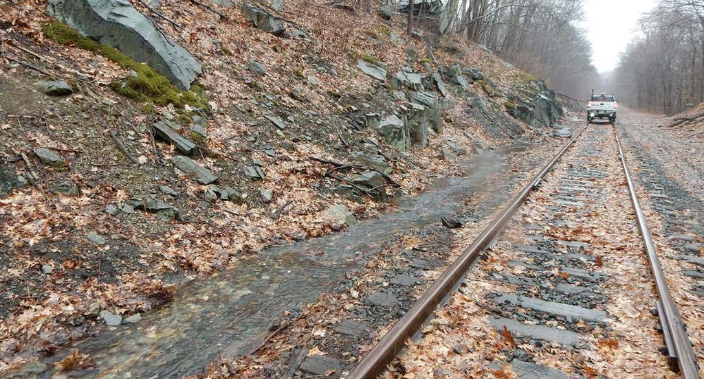
19 Single-track bridges - Only at that location (at MP 31.03) a new superstructure will need to be constructed as part of this project. At other locations the Design-Builder will utilize the existing superstructure Narrow right-of-way - There are many constrained corridors due to the natural rock features/walls. Tracks down the center - Some sections of the track are currently located in the center of the corridor. Existing infrastructure - While improvements will be necessary, the existing line provides a level surface and consistent corridor which generally eliminates costly property acquisitions and reduces construction costs. Scenic and separated - Users will appreciate the level of comfort and access to views not normally available from the roadway. Fiber Optic Line - MNR installed a fiber optic communications line that runs the length of the corridor. The line has handholes and other atgrade structures that must be considered in the final design of the trail. The line should be left in place and undisturbed; if relocation of any portions of the line are required, the final design team must review thiese changes with MNR before proceeding. Rock faces ddjacent to right-of-way 10

20 02 PROPOSED TRAIL ROUTE


21 INTRODUCTION The preferred alignment for the Beacon Line Rail Trail follows the alignment of the Beacon Line from Brewster, NY to Hopewell Junction, NY. This line does not have active railroad service as this time. The trail begins at the northern end of the Maybrook Trailway, at Tonetta Road in Brewster, and ends at the Hopewell Rail Yard in Hopewell Junction, where it will connect to the existing Dutchess Rail Trail. The trail will comprise a total of 23.5 miles of off-road routes. This Concept Plan recommends an interim connection between the Putnam Trailway and the Maybrook Trailway using Route 6 and Main Street. This on-road section will provide connectivity for the Empire State Trail system until the proposed bridge over the Harlem Line is completed. The entity responsible for construction of the on-road connection has yet to be determined. Before Trail Construction - Pawling After Trail Construction - Pawling The Beacon Line Rail Tail will provide a safe and enjoyable space for bicycling and walking for all ages and abilities. 12


22 Proposed Trail Route BEACON LINE RAIL TRAIL CONCEPT PLAN TRAIL DETAILS TRACK ALIGNMENT The preliminary assessment of the trail alignment identified several areas where the existing track may conflict with the trail. MNR has provided preliminary pricing guidelines for estimating the cost of the track work, which includes removal of the existing track and installation of new track in the realigned location. The cost of this work is outside the project s budget. On an interim basis, the initial alignment of the trail will need to work around the existing track positions, which should be achievable while remaining within the railroad ROW. The map indicates the current location of the track within the right-of-way. The next pages describe the recommended track crossings. Existing Conditions - West of Old Route Track begins to center heading west from Old Route. Existing Conditions - East of Old Route As shown in the image, the track is currently on the north side of the corridor just east of the Old Route intersection. Farther east, however, the track is located on the south side of the corridor. 13
23 LA GRANGE Tymor Park UNION VALE 55 DOVER WAPPINGER BEEKMAN PARKWAY Sylvan DUTCHESS RAIL TRAIL Hopewell Junction STATE TACONIC 216 PAWLING 22 EAST FISHKILL Village of Pawling Whaley 55 APPALACHIAN TRAIL MAP DUTCHESS COUNTY PUTNAM COUNTY White Pond HERE Wonder State Park PATTERSON KENT Clarence Fahnestock Memorial State Park TACONIC STATE Nimham Mountain Putnam County Park Carmel 22 PARKWAY PUTNAM VALLEY West Branch CARMEL BEACON LINE RAIL TRAIL: EXISTING TRACK LOCATION WITHIN ROW Centered North South 6 PUTNAM TRAILWAY 6 Village of Brewster Bog Brook SOUTHEAST East Branch 6 Miles N 14 LB
24 Proposed Trail Route BEACON LINE RAIL TRAIL CONCEPT PLAN TRACK CROSSINGS Instead of relocating the tracks, the Plan proposes crossing the tracks at six locations. Two of these locations are existing grade crossings; a third is a temporary crossing apparently created by MNR; the fourth, fifth, and sixth would be new crossings. A description of each location follows. 1. Fishkill Creek (MP 12.97): Heading eastbound, along the recommended trail through Hopewell Yard, the trail will be located on the north side of the track as it approaches the bridge over Fishkill Creek. The trail right-of-way south of the Fishkill Creek bridge is located on the southern side of the track. A track crossing is recommended west of the bridge over Fishkill Creek. 2. Stormville Road/Old Rte. (MP 16.13): Heading eastbound, the trail will approach the existing Stormville Road/Old Rte. grade crossing on the south side of the existing tracks, use the road s grade crossing to move to the north side, and then continue along the north side. The approaches to the crossing are relatively flat on both sides of the road, but some grading will be required to construct the trail. There appears to be sufficient width in the ROW to accommodate the work. 3. Private Crossing off Rte. 164 (MP 30.71): Heading eastbound, the trail will approach this existing private grade crossing on the north side of the tracks and cross over to the south side using the crossing. The crossing will require improvements to make it suitable for bicycle use. There is sufficient room on the north side of the track to construct the trail to the west of the crossing; east of the crossing considerable grading will be required to accommodate the trail until the track shifts sufficiently to the north to get the trail back on top of the prism. There appears to be sufficient width in the ROW to accommodate the work. 4. Muddy Brook Culvert (MP 31.31): East of the Harlem Line bridge, the tracks shift from the north side of the alignment to the south side for about two miles. There is not sufficient room to construct the trail to the south of the track s current position without extensive grading and potentially filling in the wetlands along Muddy Brook and Ice Pond, so crossing the tracks is required. There are also no existing grade crossings that can be used. There appears to be a wide spot in the corridor just east of the Muddy Brook culvert that will accommodate the trail on the south side approaching the crossing and the north side east of it. The crossing will be constructed to allow passage of bicycles and pedestrians. 5. Ice Pond (MP 33.10): The track returns to the north side of the corridor at the south end of Ice Pond, which will require the trail to cross back to the south side. There is an existing temporary crossing at this location, which appears to have been created to allow maintenance vehicles to access the corridor between this point and the Harlem Line bridge. The trail project will improve this temporary crossing to allow for pedestrian and bicycle use. 6. Harlem Line Connector Crossing (MP 33.70): There is a spur track connecting the Harlem Line to the Beacon Line at approximately MP 33.70; this connection is on the south side of the Beacon Line tracks, which is also where the trail will be located through this section. A maintenance crossing has been created over the spur tracks; it will be improved to provide for bicycle and pedestrian traffic. Fencing to separate this area from the Harlem Line will also be required. 15
25 LA GRANGE Tymor Park UNION VALE 55 DOVER WAPPINGER BEEKMAN PARKWAY Sylvan DUTCHESS RAIL TRAIL Hopewell Junction STATE 1 TACONIC 216 PAWLING 22 2 EAST FISHKILL Village of Pawling Whaley 55 APPALACHIAN TRAIL MAP DUTCHESS COUNTY PUTNAM COUNTY White HERE Pond Wonder State Park 3 PATTERSON KENT Clarence Fahnestock Memorial State Park TACONIC STATE Nimham Mountain Putnam County Park Carmel PARKWAY PUTNAM VALLEY West Branch PUTNAM TRAILWAY CARMEL BEACON LINE RAIL TRAIL: EXISTING TRACK ALIGNMENT AND PROPOSED TRACK CROSSINGS Centered North South Track Crossing 6 6 Village of Brewster Bog Brook SOUTHEAST East Branch 6 Miles N 16 LB
26 Proposed Trail Route BEACON LINE RAIL TRAIL CONCEPT PLAN CROSS-SECTIONS The various types and widths of rights-of-way along the Beacon Rail Line require multiple crosssections. These include two preferred options, a reduced option for more narrow rights-of-way, as well as three special case options for undergrade bridges, undergrade culverts, and overhead bridges. PREFERRED OPTION A The primary preferred cross-section includes a 10-foot wide paved shared-use path with 2-foot shoulders on either side. The edge of the shoulder is 10 feet from the centerline of the track and includes a maintenance road on the opposite side of the tracks. Preferred A Shoulder 2 ft Shared-Use Path 10 ft Shoulder 2 ft Setback 10 ft Maintenance Road Not to Scale 17
27 PREFERRED OPTION B The secondary preferred cross-section is similar to the Preferred A cross-section. It also includes a 10-foot wide paved shared-use path with 2-foot shoulders on either side. The setback between theedge of the shoulder and the centerline of the track is wider (17 feet) to make room for a maintenance road. Preferred B REDUCED The reduced option removes the maintenance road from the cross-section. The paved sharedused path is still 10 feet with 2-foot shoulders on either side and the edge of the shoulder is 8 feet 6 inches from the track centerline. Reduced Shoulder 2 ft Shared-Use Path 10 ft Shoulder 2 ft Setback/Maintenance Road 17 ft Shoulder 2 ft Shared-Use Path 10 ft Shoulder 2 ft Setback 8 ft 6 in Not to Scale Not to Scale 18
28 Proposed Trail Route BEACON LINE RAIL TRAIL CONCEPT PLAN UNDERGRADE BRIDGE The trail and track alignments are separated when going over undergrade bridges. The trail will use existing superstructure where possible with additional decking. The shared-use path will be 10 feet wide with fences on either side. UNDERGRADE CULVERT The undergrade culvert cross-section is similar to the Reduced option with the same paved shared-use path (10 feet), shoulder (2 feet), and setback (8 feet 6 inches) configuration. Currently, where the alignment travels over an undergrade culvert, the track centerline is placed 10 feet from the edge of the undergrade culvert. Bridge Culvert Shared-Use Path 10 ft Shoulder 1 ft Shared-Use Path 10 ft Shoulder 1 ft Setback 8 ft 6 in Culvert Edge to Track Centerline 10 ft Not to Scale Not to Scale 19

29 OVERHEAD BRIDGE The overhead bridge cross-section includes a paved shared-use path with shoulders on either side. This cross-section is included to depict the elements included in this special case option. Dimensions are not included in this option as each overhead bridge will require unique designs. Shoulder Shared-Use Path Shoulder Setback Not to Scale *Overhead bridge not shown in plan view. 20


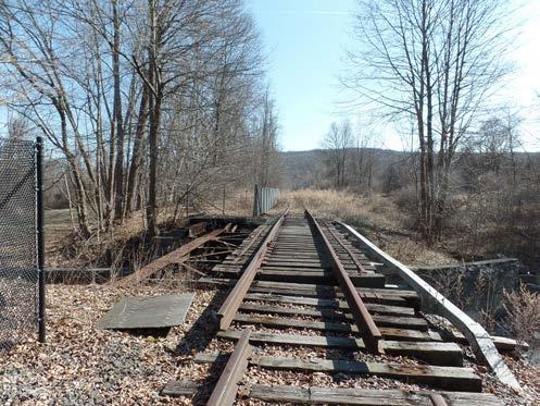
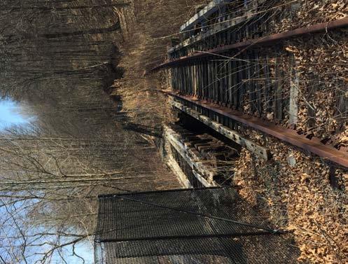
30 Proposed Trail Route BEACON LINE RAIL TRAIL CONCEPT PLAN UNDERGRADE OPEN DECK BRIDGES There are ten existing undergrade bridges along the rail alignment that will require improvements to complete the trail. For the most part, the structural elements of these undergrade bridges (abutments and main carrying beams) are intact and serviceable based on field observations by the MNR s structural engineer, although some will require repairs to either the stone or masonry structures or the steel elements that remain. Retaining as much of the existing structures as possible is important to minimize design and construction costs and to reduce the project s exposure to permitting and secondary improvements that might be necessary with a more extensive bridge replacement approach. The design intent is to utilize the existing structures to provide a functional, efficient, and cost effective solution to allow for reestablishing crossings along the rail trail corridor. Based on these goals, the existing structure of the undergrade bridges will be utilized and the proposed work will consist of the construction of timber decking and wood or metal railings on top of the existing rail structures. To connect the decking to the bridge, a supporting framework will be mounted to the existing bridge structure. Work to abutments and existing structures will be limited to any structural and cosmetic repairs necessary to put them into a serviceable and durable condition. One undergrade bridge (MP 31.03) on this section lacks the steel superstructure that was originally constructed for the undergrade bridge, and thus will require an entirely new span attached to the existing abutments. The design intent for this undergrade bridge will be to match the structural system and aesthetic character of the other bridges along this new trail section and those that have already been rebuilt elsewhere along the Beacon Line; however, should a different structural type, such as a pre-engineered, modular, prefabricated weathering steel truss bridge, offer significant cost savings over matching the other bridges, the option will be considered. In either case, the existing abutments will be assessed, and work to abutments and existing structures would be limited to structural and cosmetic repairs. Pre-Fabricated Bridge Examples 21
31 LA GRANGE UNION VALE WAPPINGER DUTCHESS RAIL TRAIL Tymor Park Undergrade Bridges Requiring Improvement MP Harlem Line (Bridge ) MP Route 164 (Bridge 6656) MP Route 164 (Bridge 6727) MP Route 164 (Bridge 6726) BEEKMAN DOVER MP Route 311/Cattle Pass (Bridge 6709) MP Green Haven Pond (Bridge 6702) MP Eders Creek (Bridge 6701) MP Seaman Road (Bridge 6682) MP PARKWAY MP Cattle Pass (Bridge 6725) Sylvan MP Fishkill Creek (Bridge 6678) Hopewell Junction STATE TACONIC 216 MP PAWLING 22 EAST FISHKILL MP Village of Pawling MP Whaley 55 APPALACHIAN TRAIL DUTCHESS COUNTY PUTNAM COUNTY White Pond MP Wonder State Park MP PATTERSON MP KENT TACONIC STATE MP MP Clarence Fahnestock Memorial State Park Nimham Mountain Putnam County Park Carmel MP PARKWAY BEACON LINE RAIL TRAIL: UNDERGRADE BRIDGES REQUIRING IMPROVEMENT PUTNAM VALLEY Undergrade Bridges Requiring Improvement Existing Shared-Use Path Beacon Line Right-of-Way Miles N CARMEL West Branch 6 PUTNAM TRAILWAY 6 Village of Brewster 6 Bog Brook SOUTHEAST East Branch 22 LB


32 Proposed Trail Route BEACON LINE RAIL TRAIL CONCEPT PLAN Green Haven Pond Undergrade Bridge (MP 18.24) Eders Creek Undergrade Bridge (MP 16.92) Fishkill Creek Undergrade Bridge (MP 13.06) 23

 Route 311 30.")
 Route 164 (North)")
 30.37) 24")
33 Seaman Road Undergrade Bridge (MP 16.59) Seaman Road Undergrade Bridge (MP 16.59) Route 311 Undergrade Bridge (MP 30.02) Route 311 Undergrade Bridge (MP 30.02) Route 164 (North) Undergrade Bridge (MP 30.37) Route 164 (North) Undergrade Bridge (MP 30.37) 24


34 Proposed Trail Route BEACON LINE RAIL TRAIL CONCEPT PLAN UNDERGRADE CULVERTS In addition to the undergrade bridges, there are numerous undergrade culverts along the alignment. These provide passage for cattle, drainage, and streams. The undergrade culverts in almost all instances take one of two forms: A pipe or culvert section, typically steel or concrete; Rail Top A short span bridge, constructed using rail sections placed longitudinally over two abutments with concrete cast over the top of the rail sections. These undergrade culverts were originally constructed to clear the width of a two-track layout; most were measured in the field at 31 to 34 feet in width at the top of the undergrade culvert, which should provide sufficient width to add the trail using the Reduced cross section described above. The side slopes of the embankments are typically very steep at these undergrade culverts (2 horizontal to 1 vertical or steeper); the short-span bridges are typically four to six feet above grade, plus an additional two to three feet of railbed section above the bridge, leaving a potential fall height of as much as seven to ten feet. For protection of trail users, safety fencing should be provided above the undergrade culverts. A four-foot high, bicycle friendly wooden rail fence is recommended. The fence should be comprised of 6 x6 timber posts with two 2 x6 rails. Frog Hollow Brook Undergrade Culvert Undergrade Culvert near Frog Hollow Road 25


35 OVERHEAD BRIDGES There are several roads that pass over the Beacon Line along the length of the trail project. These carry major highways, such I- and the Taconic Parkway, and county and local roads, such as Tonetta Road and County Road 312. The primary impact of these overhead bridges will be constraints on trail width due to clear space available between the bents or abutment walls supporting the overhead bridges. In some cases, it may be possible to adjust the track location slightly to increase the available width for the trail. If not, shoulder width or even trail width may have to be reduced through the length of the overhead bridge. In no case should the trail width be reduced below 8 feet clear. Route 292 Overhead Bridge Carpenter Road (Route 29) Overhead Bridge View of Corridor from Carpenter Road (Route 29) Overhead Bridge 26

36 Proposed Trail Route BEACON LINE RAIL TRAIL CONCEPT PLAN TRAILHEADS Five trailheads and two gateways are recommended to provide users a place to easily access the trail. These trailheads can include parking areas, wayfinding signage, and various amenities such as bike repair stations, benches, picnic tables, and bike racks. The following locations provide examples of potential trailheads. Additional study is needed to refine final trailhead locations. The locations of these trailheads are tentative and based on current knowledge of the corridor. Exact locations will depend on factors such as existing rights-of-way, consultation with involved local officials, and public input. GATEWAYS Empire State Trail Gateways are significant trailheads that reflect local culture and emphasize the connection to a statewide trail system. Each gateway will be an actively managed park with a full array of amenities. Markel Park, Brewster (Gateway) Southeast Town Park/ Tonetta Beach, Southeast Route 164, Patterson Holmes Road, Pawling Appalachian Trail, Pawling Old Route, East Fishkill Dutchess Rail Trail Trailhead (existing), Hopewell Junction (Gateway) Southeast Town Park/ Tonetta Beach The existing parking at this location can be used as a base for a trailhead. Additional amenities can be added to provide resources for trail users. A trailhead can include a parking area, benches, picnic tables, and other amenities and includes wayfinding and perhaps other information about the history of the area and trail. 27

 values of each roadway.")

 Bike Lane Marked")
37 ON-ROAD RECOMMENDATIONS On-road recommendations were made using the standards within the Empire State Trail Design Guide. This included analyzing the speed limit and average annual daily traffic (AADT) values of each roadway. AT-GRADE ROAD CROSSING RECOMMENDATIONS Roadway crossing recommendations were made for each at-grade crossing using the standards within the Empire State Trail Design Guide. This included analyzing the speed limit, number of lanes, and functional classification of each roadway. Shared Roadway Rapid Rectangular Flash Beacon (RRFB) Bike Lane Marked Crosswalk with Yield Lines 28

38 Proposed Trail Route BEACON LINE RAIL TRAIL CONCEPT PLAN DRAINAGE Drainage of the trail will be handled primarily by sheet flow off the path surface and into the existing drain system for the railroad. Considering the lack of permeability of the highly compacted soils beneath the existing roadbed, the trail will not significantly increase the amount of impermeable surface in the corridor, and so there should be sufficient capacity within the system to accept the additional runoff. There are sections where the railbed is currently not draining well, such as around MP 21 (between Depot Hill Road and Bard Street) and near the Green Haven Correctional Facility, and improvements to correct the drainage flow and accept the additional runoff will be required. In these areas, swales paralleling the trail will be required, and in some instances piping of stormwater may also be required, although the intent is to minimize the amount of piping and structures. It will be important to maintain adequate drainage from the remaining rail so that water does not interfere with the operation of trains. To accomplish this, the pathway should be cross-pitched away from the remaining rail line rather than being crowned, which would trap water between the railroad and the trail. A portion of the Beacon Line Rail Trail lies within the NYC Watershed, managed by New York City Department of Environmental Protection (NYCDEP). Approximately 10.5 miles of the Rail Trail is within the NYC watershed, but potentially only 3.7 of these miles are subject to NYCDEP mitigation due to proximity to water resources. Under NYC DEP s regulations, more extensive stormwater collection and conveyance systems will be required, including continuous swales adjacent to the trail, structured outfalls into existing water bodies and streams, and other best practices to maintain water quality. MNR will review the project with NYCDEP staff is needed to determine the extent of the stormwater system within this area; see Environmental Review and Permitting Requirements under Next Steps in this document for more information. Drainage Issues - Route 292, Pawling 29

39 30
40 LB Proposed Trail Route BEACON LINE RAIL TRAIL CONCEPT PLAN PROPOSED TRAIL ROUTE WAPPINGER LA GRANGE Tymor Park 55 BEEKMAN UNION VALE DOVER The proposed trail alignment primarily follows the existing track alignment. There are short on-road segments recommended in the southern section of the trail connecting to the Putnam Trailway. DUTCHESS RAIL TRAIL Hopewell Junction EAST FISHKILL TACONIC PARKWAY STATE Sylvan 216 Whaley PAWLING 55 Village of Pawling 22 SECTION 1 This plan recommends creating on-road routes to connect the existing Putnam Trailway and Maybrook Trailway. Bicyclists can utilize the recommended shared roadways, paved shoulders, and bike lanes on Putnam Avenue, Carmel Avenue (Route 6), and North Main Street, respectively. Pedestrians can use the shared roadways and existing sidewalks. To further accommodate pedestrians, new sidewalks are recommended on the northern portion of North Main Street. Clarence Fahnestock Memorial State Park TACONIC STATE PARKWAY PUTNAM VALLEY APPALACHIAN TRAIL DUTCHESS COUNTY PUTNAM COUNTY White Pond KENT Nimham Mountain CARMEL Putnam County Park West Branch 6 Carmel PUTNAM TRAILWAY Wonder State Park Village of Brewster PATTERSON 164 SOUTHEAST 6 Miles Bog Brook 1 East Branch N 202 Multiple crossing recommendations are made to provide safe road crossings for bicyclists and pedestrians on the trail: Putnam Trailway at Putnam Avenue, Brewster: Marked and Signed Crosswalk Maybrook Trailway at North Main Street, Brewster: RRFB Crossing Pumphouse Road, Southeast: Marked Crosswalk with Yield Lines Southeast Town Park/ Tonetta Beach, Southeast: Marked and Signed Crosswalk A trailhead is recommended at Southeast Town Park and Tonetta Beach and a gateway is recommended at Markel Park in Brewster. 31
41 SECTION 2 62 Farm To Market Rd PATTERSON ICE POND Foggintown Rd 62 SOUTHEAST MAP 58 Brewster Hill Rd HERE LAKE SOUTHEAST TOWN PARK TONETTA BOG BROOK RESEVOIR PUTNAM TRAILWAY Prospect Hill Rd Pumphouse Rd Tonetta Rd BEACON LINE RAIL TRAIL SECTION 1: PROPOSED TRAIL ROUTE MAP 22 MIDDLE BRANCH RESEVOIR Carmel Ave Putnam Ave 6 N Main St MAYBROOK TRAILWAY Existing Shared-Use Path Existing Sidewalk Shared-Use Path Paved Shoulder Bike Lane Shared Roadway RRFB Crossing Marked Crosswalk with Yield Lines Marked and Signed Crosswalk Proposed Trailhead Undergrade Culvert Overhead Bridge VILLAGE OF BREWSTER Sidewalk Beacon Line ROW Not Used For Trail Miles N 32 LB 32
42 LB Proposed Trail Route BEACON LINE RAIL TRAIL CONCEPT PLAN SECTION 2 LA GRANGE Tymor Park UNION VALE Two crossing recommendations are made to provide safe road crossings for bicyclists and pedestrians on the trail: WAPPINGER DUTCHESS RAIL TRAIL Hopewell Junction PARKWAY STATE Sylvan 55 BEEKMAN DOVER Holmes Road, Pawling: RRFB Crossing TACONIC 216 PAWLING 22 Beaver Brook Road, Pawling: Marked and Signed Crosswalk Two trailheads are recommended at Route 164 in Patterson and at Holmes Road in Pawling. EAST FISHKILL APPALACHIAN TRAIL DUTCHESS COUNTY PUTNAM COUNTY White Pond Whaley 55 Village of Pawling 2 In order to utilize the right-of way, decking and improvements are recommended for all six railroad bridges within this section (MP 31.20, MP 31.03, MP 30.62, MP 30.37, MP 30.20, and MP 30.02). Clarence Fahnestock Memorial State Park TACONIC STATE PARKWAY KENT Nimham Mountain Putnam County Park West Branch Carmel PUTNAM TRAILWAY Wonder State Park 311 PATTERSON Bog Brook PUTNAM VALLEY CARMEL 6 6 Village of Brewster SOUTHEAST East Branch Miles N
43 SECTION 3 Bundy Hill Rd SECTION PAWLING 69 DENTON LAKE Holmes Rd DUTCHESS COUNTY PUTNAM COUNTY WESTMINSTER LAKE Harmony Rd PATTERSON S VETERAN MEMORIAL PARK Mooney Hill Rd Cross Rd GREAT SWAMP MAP 311 HERE Cushman Rd Couch Rd PATTERSON GREAT SWAMP WILDLIFE MANAGEMENT AREA 43 WONDER LAKE Couch Rd KENT Ludingtonville Rd TURTLE POND BEACON LINE RAIL TRAIL SECTION 2: PROPOSED TRAIL ROUTE MAP Shared-Use Path RRFB Crossing Marked and Signed Crosswalk Proposed Trailhead Undergrade Bridge Undergrade Culvert Overhead Bridge Miles N 34 LB 34
44 LB Proposed Trail Route BEACON LINE RAIL TRAIL CONCEPT PLAN SECTION 3 LA GRANGE Tymor Park UNION VALE Four crossing recommendations are made to provide safe road crossings for bicyclists and pedestrians on the trail: WAPPINGER DUTCHESS RAIL TRAIL Hopewell Junction PARKWAY STATE Sylvan 55 BEEKMAN 3 DOVER Route 292, Pawling: RRFB Crossing TACONIC 216 PAWLING 22 Appalachian Trail, Pawling: Marked and Signed Crosswalk Bard Road, Beekman: Marked and Signed Crosswalk EAST FISHKILL APPALACHIAN TRAIL DUTCHESS COUNTY PUTNAM COUNTY White Pond Whaley 55 Village of Pawling Depot Hill Road, Beekman: Marked Crosswalk with Yield Lines KENT Wonder State Park 311 PATTERSON 164 One trailhead is recommended at Route 292 in Pawling. Clarence Fahnestock Memorial State Park TACONIC STATE PARKWAY Nimham Mountain Putnam County Park West Branch Carmel 22 PUTNAM TRAILWAY Bog Brook PUTNAM VALLEY CARMEL 6 6 Village of Brewster SOUTHEAST East Branch Miles N
45 Depot Hill Rd 32 APPALACHIAN TRAIL Old Route 55 NUCLEAR LAKE Penny Rd SECTION 4 APPALACHIAN TR AIL MAP Old Route 55 DEPOT HILL HERE Little Pond Rd Harmony Hill Rd LITTLE WHALEY LAKE PAWLING BEEKMAN WHALEY LAKE Harmony Rd 69 Byrne Rd SECTION 4 BEACON LINE RAIL TRAIL SECTION 3: PROPOSED TRAIL ROUTE MAP Shared-Use Path Marked Crosswalk with Yield Lines RRFB Crossing Proposed Trailhead Marked and Signed Crosswalk Undergrade Culvert Overhead Bridge Miles N 36 LB 36
46 LB Proposed Trail Route BEACON LINE RAIL TRAIL CONCEPT PLAN SECTION 4 LA GRANGE Tymor Park UNION VALE Two crossing recommendations are made to provide safe road crossings for bicyclists and pedestrians on the trail: WAPPINGER DUTCHESS RAIL TRAIL Hopewell Junction PARKWAY STATE Sylvan 55 BEEKMAN 4 DOVER South Green Haven Road, Beekman: RRFB Crossing EAST FISHKILL TACONIC 216 PAWLING Village of Pawling 22 Old Route, East Fishkill: Marked Crosswalk with Yield Lines One trailhead is recommended at Old Route in East Fishkill. APPALACHIAN TRAIL DUTCHESS COUNTY PUTNAM COUNTY White Pond Whaley Wonder State Park 55 PATTERSON In order to utilize the right-of way, decking and improvements are recommended for all three railroad bridges within this section (MP 18.24, MP 16.92, and MP 16.59). Clarence Fahnestock Memorial State Park TACONIC STATE PARKWAY KENT Nimham Mountain Putnam County Park West Branch Carmel PUTNAM TRAILWAY Bog Brook PUTNAM VALLEY CARMEL 6 6 Village of Brewster SOUTHEAST East Branch Miles N
47 Brothers Rd Sylvan Rd 9 Beekman Poughquag Rd SECTION 3 SYLVAN LAKE 10 Beekman Rd SECTION 5 9 BEEKMAN EAST FISHKILL 216 GREEN HAVEN MAP CORRECTIONAL FACILITY 8 Stormville Rd 216 Green Haven RdS Green Haven Rd HERE SECTION 3 Old Route Eder Rd SECTION 5 Seaman Rd Devon Farms Rd APPALACHIAN TRAIL SECTION 3 BEACON LINE RAIL TRAIL SECTION 4: PROPOSED TRAIL ROUTE MAP Shared-Use Path Pedestrian Hybrid Beacon Crossing RRFB Crossing Marked Crosswalk with Yield Lines Proposed Trailhead Undergrade Bridge Undergrade Culvert Overhead Bridge Miles N 38 LB 38
48 LB Proposed Trail Route BEACON LINE RAIL TRAIL CONCEPT PLAN SECTION 5 LA GRANGE Tymor Park UNION VALE Two crossing recommendations are made to provide safe road crossings for bicyclists and pedestrians on the trail: WAPPINGER DUTCHESS RAIL TRAIL Hopewell Junction PARKWAY STATE 5 Sylvan 55 BEEKMAN DOVER Route 216, East Fishkill: Pedestrian Hybrid Beacon Crossing EAST FISHKILL TACONIC 216 PAWLING Village of Pawling 22 East Fishkill Recreation Path at Church Street, East Fishkill: Marked and Signed Crosswalk There is an existing trailhead at the southern end of the Dutchess Rail Trail in Hopewell Junction. While this trailhead currently exists, this plan recommends additional bicycle and motor vehicle parking spaces as well as other amenities be added to the trailhead. The trailhead in Hopewell Junction will also double as an Empire State Trail Gateway. Clarence Fahnestock Memorial State Park TACONIC STATE PARKWAY PUTNAM VALLEY APPALACHIAN TRAIL DUTCHESS COUNTY PUTNAM COUNTY White Pond KENT Nimham Mountain CARMEL 6 Putnam County Park West Branch Whaley Carmel PUTNAM TRAILWAY Wonder State Park Village of Brewster PATTERSON Bog Brook SOUTHEAST East Branch N 202 Based on the surrounding area and lack of connections south of MP (Bridge 6678), decking and improvements are recommended to enable trail users to cross Fishkill Creek Miles Immediately following the bridge, it is recommended trail users cross the track and utilize a proposed shared-use path through Hopewell Yard. This shared-use path will connect to the Dutchess Rail Trail beneath the overhead bridge at Route
49 DUTCHESS RAIL TRAIL Railroad Ave HOPEWELL JUNCTION RED WING PARK 82 Clove Branch Rd 9 29 Beekman Rd Taconic State Parkway SECTION 4 82 BEACON LINE EXTENSION Church St HOPEWELL RECREATION PARK 29 Stormville Rd GOLF COURSE MAP EMMADINE POND TOWN PARK Carpenter Rd HERE Taconic State Parkway SECTION 4 EAST FISHKILL Lime Kiln Rd SECTION 4 27 APPALACHIAN TRAIL BEACON LINE RAIL TRAIL SECTION 5: PROPOSED TRAIL ROUTE MAP Existing Shared-Use Path Shared-Use Path Pedestrian Hybrid Beacon Crossing Proposed Trailhead Undergrade Bridge Undergrade Culvert Overhead Bridge Miles N 40 LB 40
50 Proposed Trail Route BEACON LINE RAIL TRAIL CONCEPT PLAN COST ESTIMATE A preliminary opinion of probable cost has been prepared for the project, based on the level of design information and existing conditions data available at the time of the feasibility study. The estimate assumes two different levels of earthwork to fit the trail into the existing corridor: a simple section, where only a footprint of approximately twice the width of the trail is disturbed and minimal excavation and grading; and a complex footprint, which assumes a footprint of four times the trail width with greater excavation and filling requirements. These crosssections were developed for 10-foot and 12-foot wide trails using both asphalt and stone dust paving. Added to these basic trail construction costs were: The work required to make the bridges usable; Trail amenities such as trailheads, site furniture, wayfinding signage, fencing, and other improvements; Drainage and utility work; Improvements at road crossings; Track work for the realignments and other changes needed to complete the trail; and The on-road segments at the north and south ends of the trail. A summary of the major items is provided below; a more detailed breakdown of the estimate is attached as an appendix. The estimate also includes a number of multipliers to reflect the hard and soft costs of the total project as follows: Construction Escalation - 5% per year: This allows for inflation of costs due to the overall timeline for project delivery. Escalation is calculated at the midpoint of construction, which is assumed to be mid- to late-2019; hence 10% escalation has been applied to the total contract price. Engineering and Survey - 15%: include survey, geotechnical explorations and analysis and consultant fees for design, permitting, and construction phase services. General Contingency - 25%: This reflects the basis of the estimate; at this point, not much is known about the details of the design or the existing conditions because of the early stage of the project. The contingency should be reduced at each progressive stage of the design, ultimately being eliminated at the time of bidding. The total cost for the project, including the above multipliers, is currently estimated between $38 and $43 million (under review). 41
51 Page left intentionally blank 42

52 03 ACTION PLAN
Appendix 3. Greenway Design Standards. The Whitemarsh Township Greenway Plan
 Appendix 3 Greenway Design Standards This chapter discusses two design standards for the greenway types discussed above. First, trail design standards are presented together with trailhead facilities and
Hudson Highlands Fjord Trail Draft Master Plan. April 29, 2015
 Hudson Highlands Fjord Trail Draft Master Plan April 29, 2015 Agenda Route Overview Proposed Segment Results of Community Survey on that Segment Next Steps Municipal Endorsement Environmental Review Implementation
Auburn Trail / Ontario Pathways Trail Connector Feasibility Study Public Information Meeting Wednesday, August 22, 2012
 Auburn Trail / Ontario Pathways Trail Connector Feasibility Study Public Information Meeting Wednesday, August 22, 2012 Purpose of Feasibility Study Purpose Evaluate the feasibility of constructing a multiuse
2. Goals and Policies. The following are the adopted Parks and Trails Goals for Stillwater Township:
 D. PARKS AND TRAILS 1. Introduction Stillwater Township s population is relatively low, with most residents living on rural residences on large lots. The need for active park space has been minimal in
FEASIBILITY CRITERIA
 This chapter describes the methodology and criteria used to evaluate the feasibility of developing trails throughout the study areas. Land availability, habitat sensitivity, roadway crossings and on-street
ANCLOTE COASTAL TRAIL ALTERNATIVES ANALYSIS STUDY
 ANCLOTE COASTAL TRAIL ALTERNATIVES ANALYSIS STUDY PASCO COUNTY MPO JULY 2015 PROJECT OVERVIEW... INTRODUCTION EXECUTIVE SUMMARY CONTEXT... TAMPA BAY AREA, PINELLAS, & PASCO COUNTY S MULTI-USE TRAIL PLANS
Georgetown-Lewes Rail/Trail Study. Rail/Trail Study: Cool Spring to Cape Henlopen State Park New Road Extension (House Resolution No.
 Georgetown-Lewes Rail/Trail Study Rail/Trail Study: Cool Spring to Cape Henlopen State Park New Road Extension (House Resolution No. 47) August 22, 2011 Presentation Outline Background Benefits Statewide
Understanding user expectations And planning for long term sustainability 1
 Understanding user expectations And planning for long term sustainability 1 What is a natural surface trail? It can be as simple has a mineral soil, mulched or graveled pathway, or as developed as elevated
City of Durango 5.8 FUNDING TRAILS DEVELOPMENT
 5.8 FUNDING TRAILS DEVELOPMENT The City has been successful in establishing dedicated local funding sources as well as applying for grants to develop the City s trail system, having received nearly $2.4
Trail # NW Tuesday, June DESIGN. Provide an Review the Provide an. Project Goals: System system. wayfinding
 I. Welcome / Introductions Bethany Creek Trail #2 Segment 3 Neighborhood Meeting #1 Bethany Presbyterian Church 15505 NW Springville Road, Portland, OR 97229 Tuesday, June 26, 2018 @ 6:00PM Meeting Minutes
Citrus Heights Creek Corridor Trail Project Trail Advisory Group Field Trip #2 September 11, :00 11:00 am Trellis Hall, Citrus Heights
 September 11, 2013 9:00 11:00 am Trellis Hall, Citrus Heights Project Overview The City of Citrus Heights is studying the feasibility of establishing a multi use trail system within the City s 26 miles
AGENDA ITEM 5 D WAKULLA ENVIRONMENTAL INSTITUTE (WEI) TRAIL FEASIBILITY STUDY
 TRAIL FEASIBILITY STUDY") March 19, 2018 AGENDA ITEM 5 D WAKULLA ENVIRONMENTAL INSTITUTE (WEI) TRAIL FEASIBILITY STUDY TYPE OF ITEM: Action STATEMENT OF ISSUE The Wakulla Environmental Institute (WEI) Trail is one of several trails
March 19, 2018 AGENDA ITEM 5 D WAKULLA ENVIRONMENTAL INSTITUTE (WEI) TRAIL FEASIBILITY STUDY TYPE OF ITEM: Action STATEMENT OF ISSUE The Wakulla Environmental Institute (WEI) Trail is one of several trails
At the time, the portion of the line through Eagle County remains wholly under the ownership of Union Pacific Railroad (UP).
.") Chapter 5 The Railroad Corridor as a Trail Corridor The intent of this chapter is to identify how the rail corridor, if available for lease or purchase in all or part, could be incorporated into the core
Chapter 5 The Railroad Corridor as a Trail Corridor The intent of this chapter is to identify how the rail corridor, if available for lease or purchase in all or part, could be incorporated into the core
Trail Feasibility Study
 VOLUSIA COUNTY MPO CITY OF NEW SMYRNA BEACH FINAL REPORT JUNE 30, 2009 Trail Feasibility Study What s inside? 1 Introduction 2 Project Purpose & Scope 3 Physical Inventory & Assessment of Right-of- Way
The Baker/Carver Regional Trail is intended to
 Section V Design Guidance The Baker/Carver Regional Trail is intended to safely accommodate 183,000 annual visits, an array of non-motorized uses, a variety of skill levels, and persons with special needs.
METROPOLITAN COUNCIL 390 North Robert Street, St. Paul, MN Phone (651) TDD (651)
 TDD (651)") METROPOLITAN COUNCIL 390 North Robert Street, St. Paul, MN 55101 Phone (651) 602 1000 TDD (651) 291 0904 DATE: June 19, 2007 TO: Metropolitan Parks and Open Space Commission FROM: Jan Youngquist, Senior
METROPOLITAN COUNCIL 390 North Robert Street, St. Paul, MN 55101 Phone (651) 602 1000 TDD (651) 291 0904 DATE: June 19, 2007 TO: Metropolitan Parks and Open Space Commission FROM: Jan Youngquist, Senior
Addendum - Airport Development Alternatives (Chapter 6)
") Bowers Field Addendum - Airport Development Alternatives (Chapter 6) This addendum to the Airport Development Alternatives chapter includes the preferred airside development alternative and the preliminary
Bowers Field Addendum - Airport Development Alternatives (Chapter 6) This addendum to the Airport Development Alternatives chapter includes the preferred airside development alternative and the preliminary
Blue River Trail Master Plan JSA to Town Hall June 2004
 Blue River Trail Master Plan JSA to Town Hall June 2004 Prepared for: Silverthorne Town Council Silverthorne SPORT Committee Department of Recreation and Culture Silverthorne Public Works Silverthorne
Longmont to Boulder Regional Trail Jay Road Connection DRAFT FINAL REPORT
 Longmont to Boulder Regional Trail Jay Road Connection DRAFT FINAL REPORT December 2018 Project Summary Boulder County, Colorado, in partnership with the City of Boulder, is evaluating options for multi-use
2016 Regional Transportation Alternatives Program (TAP) Grant Application
 Grant Application") 2016 Regional Transportation Alternatives Program (TAP) Grant Application PROJECT TITLE: Yelm-Tenino Trail Extension Feasibility Study TRPC use only GENERAL PROJECT INFORMATION Agency or Organization City
2016 Regional Transportation Alternatives Program (TAP) Grant Application PROJECT TITLE: Yelm-Tenino Trail Extension Feasibility Study TRPC use only GENERAL PROJECT INFORMATION Agency or Organization City
MORGAN CREEK GREENWAY Final Report APPENDICES
 APPENDICES MORGAN CREEK GREENWAY Appendix A Photos of Existing Conditions in Trail Corridor Photos of existing conditions Main trail corridor - February 2009 Photos of existing conditions south bank Morgan
Railroad Safety Trail
 2.1 INTRODUCTION AND PROJECT SETTING 2.1 Introduction & Project Setting Introduction This study is the result of a directed effort on the part of the City of San Luis Obispo to carry out previously established
DRAFT - APRIL 13, 2007 ROUTING STUDY FOR TRAIL CONNECTIONS BETWEEN CALAIS AND AYERS JUNCTION
 DRAFT - APRIL 13, 2007 ROUTING STUDY FOR TRAIL CONNECTIONS BETWEEN CALAIS AND AYERS JUNCTION Abstract The vision for the East Coast Greenway is an off-road urban trail system running from Calais, Maine
Coast to Coast Connector Summit
 Project Partners Welcome to the Coast to Coast Connector Summit Winter Garden, Florida City Hall October 1, 2014 1 Why are we here? Objectives 1. Inform key stakeholders on the current state of the C2C
Blueways: Rivers, lakes, or streams with public access for recreation that includes fishing, nature observation, and opportunities for boating.
 Parks, Open Space and Trails PRINCE WILLIAM COUNTY 2008 COMPREHENSIVE PLAN TRAILS PLAN CONTENTS The components of the trails plan are: Intent Definitions Goals, Policies, and Action Strategies Trails Map
ALBANY-HUDSON ELECTRIC TRAIL FEASIBILITY STUDY. Final Report OCTOBER 2011
 ALBANY-HUDSON ELECTRIC TRAIL FEASIBILITY STUDY Final Report OCTOBER 2011 ALBANY-HUDSON ELECTRIC TRAIL FEASIBILITY STUDY Prepared for: Town of East Greenbush 225 Columbia Turnpike Rensselaer, New York 12144
China Creek North Park Upgrades and Glen Pump Station. Park Board Committee Meeting Monday, July 10, 2017
 China Creek North Park Upgrades and Glen Pump Station Park Board Committee Meeting Monday, July 10, 2017 Purpose The purpose of this presentation is to: Share the results of the public engagement processes;
EAST DON TRAIL ENVIRONMENTAL ASSESSMENT. Community Liaison Committee Meeting #3 July 15, :30 to 8:30 pm Flemingdon Park Library
 EAST DON TRAIL ENVIRONMENTAL ASSESSMENT Community Liaison Committee Meeting #3 July 15, 2013 6:30 to 8:30 pm Flemingdon Park Library Agenda 1. Welcome 2. Housekeeping and Updates a) Housekeeping b) CLC
Tallahassee-St. Marks Historic Railroad Trail
 Revitalizing a Historic Trail Designated as a National Recreation Trail, the 16-mile Tallahassee-St. Marks Historic Railroad Trail has been enjoyed by countless bicyclists, runners, and outdoor enthusiasts
Chapter 4.0 Alternatives Analysis
 Chapter 4.0 Alternatives Analysis Chapter 1 accumulated the baseline of existing airport data, Chapter 2 presented the outlook for the future in terms of operational activity, Chapter 3 defined the facilities
Chapter 6: POLICY AND PROCEDURE RECOMMENDATIONS
 Chapter 6 POLICY AND PROCEDURE RECOMMENDATIONS FOR SRRA Below are seven policy elements that should be considered for adoption by the Southwest Regional Recreation Authority of Virginia: 1. Develop strategies
Northaven Trail Phase 2 Initial Project Overview
 Northaven Trail Phase 2 Initial Project Overview Partnership Project to extend existing Northaven Trail Improve Bike/Ped Connectivity On Dallas Trail Network Plan City and County Funding Oncor Texas Trails
Business Item No
 Metropolitan Parks and Open Space Commission Meeting date: February 6, 2018 For the Community Development Committee meeting of February 20, 2018 For the Metropolitan Council meeting of February 28, 2018
DATE: 23 March, 2011 TO: Communities FROM: BlazeSports America. RE: Accessible Trails Checklist 1
 M E M O R A N D U M DATE: 23 March, 2011 TO: Communities FROM: BlazeSports America RE: Accessible Trails Checklist 1 The purpose of the Accessible Trails Checklist (below) is to help the community review
Mason Street Bike/Pedestrian Trail Project
 Construction of the much-anticipated Mason Trail is underway! Mountain Constructors was awarded the contract in September but had to go through a 2- month process to obtain construction clearance permits
Little River Trail Feasibility Study
 Final April, 2014 Prepared for the State Coastal Conservancy By the Natural Resources Services Division of Redwood Community Action Agency Table of Contents Executive Summary... 1 1. Project Purpose and
3. COLTA / HUGA CONNECTIONS - PRELIMINARY
 9 3. COLTA / HUGA CONNECTIONS - PRELIMINARY 3.1 COLTA The Chain of Lakes Trail Association (COLTA) trail, formerly identified as the Chester Spur Line, was completed and opened for use in June 2011. The
4. Safety Concerns Potential Short and Medium-Term Improvements
 NH Route 104 Access Management Study Page 19 4. Safety Concerns Potential Short and Medium-Term Improvements Potential safety improvement strategies are listed by priority based on field observations by
Welcome to the Cross County Trail Public Input Session!
 Welcome to the Cross County Trail Public Input Session! Please sign in on the table below! What are we doing here? Camden County has proposed a bicycle and pedestrian trail spanning across the entire county.
Segment 2: La Crescent to Miller s Corner
 goal of the USFWS refuges is to conserve, protect and enhance fish, wildlife and plants and their habitats for the continuing benefit of the American people. Refuge lands are used largely for fishing,
Hospital Link Project Project Update Winter 2018
 Hospital Link Project Project Update Winter 2018 General The project provides a link from Riverside Drive and the Transitway to the Hospital Link Road. Construction of the Hospital Link facility is open
Lake Windermere Westside Legacy Trail. A multi-use non-motorized paved trail promoting health, wealth and outdoor appreciation
 Lake Windermere Westside Legacy Trail A multi-use non-motorized paved trail promoting health, wealth and outdoor appreciation Jan 26, 2015 Executive Summary The Lake Windermere Westside Legacy Trail will
Regional Wayfinding Sign Strategy Thurston County Trails 2017
 Regional Wayfinding Sign Strategy Thurston County Trails 2017 Partners: Members and partnering organizations of the Thurston Thrives Community Design Action Team City of Lacey, City of Olympia, City of
Gardner: overview. Santa Fe, Oregon, and California National Historic Trails UNINCORPORATED JOHNSON COUNTY OLATHE UNINCORPORATED JOHNSON COUNTY
 Santa Fe, Oregon, and California ational Historic Trails : overview 99: p.134 100: p.135 GARDER JUCTIO 102: p.137 56: p.126 EDGERTO Burlington orthern Intermodal and Logistics 98: p.133 101: p.136 S Waverly
OPEN HOUSE PRESENTATION
 Thank You For Attending Today Capital District Transportation Committee Behan Planning and Design The Chazen Companies Engineering Sidekick Creative C onsultecon, Inc. R obert B engraff Drone Pilot What
Business Item No XXX. Proposed Action That the Metropolitan Council approve the Coon Creek Regional Trail Master Plan.
 Business Item No. 2015-XXX Metropolitan Parks and Open Space Commission Meeting date: July 7, 2015 For the Community Development Committee meeting of July 20, 2015 For the Metropolitan Council meeting
Committee Report. Community Development Committee For the Metropolitan Council meeting of April 13, Business Item No.
 Committee Report Business Item No. 2016-48 Community Development Committee For the Metropolitan Council meeting of April 13, 2016 Subject: Harriet Island-South St. Paul Regional Trail Master Plan, Saint
A CASE FOR COMPLETING THE JORDAN RIVER PARKWAY: A
 A CASE FOR COMPLETING THE JORDAN RIVER PARKWAY: A safe crossing at 9000 South and 850 West Proposed 9000 South Underpass Parkway Timeline Parkway, Trail, and Tourism Facts Blueprint Jordan River 1971 1973
Section II. Planning & Public Process Planning for the Baker/Carver Regional Trail began in 2010 as a City of Minnetrista initiative.
 Section II Planning & Public Process Planning for the began in 2010 as a City of initiative. city staff began discussions with the Park District on the possibility of a north/south regional trail connection
Lafourche Parish Government REQUEST FOR QUALIFICATIONS. Landscape Architectural Services
 Lafourche Parish Government REQUEST FOR QUALIFICATIONS Landscape Architectural Services Bayou Lafourche Parish Multi-Use Path Feasibility Study Phase 1 And Bayou Lafourche Parish Multi-Use Path Feasibility
Non-motorized Trail Plan & Proposal. August 8, 2014
 Town of Star Valley Ranch, Wyoming and the Star Valley Ranch Association in partnership with the USDA Forest Service, Bridger-Teton National Forest, Greys River Ranger District Non-motorized Trail Plan
I. INTRODUCTION EAST COAST GREENWAY STUDY PURPOSE
 I. INTRODUCTION STUDY PURPOSE The purpose of this study is to determine the engineering feasibility of developing the Eastern Trail. It was initiated at the request of the and funded by the Maine Department
Appendix E: Railroad Route Evaluation, Maps and Tables
 Appendix E: Railroad Route Evaluation, Maps and Tables LandPeople E-1 Table of Contents 1.0 Railroad Operations...3 2.0 Rails-with-Trails...3 3.0 Methodology...3 4.0 Trail Design Assumptions...4 5.0 Typical
WELCOME to the Iditarod Dog Sledding Historic District (IDSHD) Workshop. January 11, Houston Middle School Houston, Alaska
 Workshop. January 11, Houston Middle School Houston, Alaska") WELCOME to the Iditarod Dog Sledding Historic District (IDSHD) Workshop January 11, 2012 Houston Middle School Houston, Alaska Workshop Purpose: Present/discuss proposed resolutions to comments received
WELCOME to the Iditarod Dog Sledding Historic District (IDSHD) Workshop January 11, 2012 Houston Middle School Houston, Alaska Workshop Purpose: Present/discuss proposed resolutions to comments received
Agenda Report. Spruce Street Outlet Drainage Improvements Tower Road Relief Sewer
 Agenda Report Subject: Prepared By: Spruce Street Outlet Drainage Improvements Tower Road Relief Sewer Steven M. Saunders, Director of Public Works/Village Engineer Date: August 12, 2012 On March 8, 2012
Lincoln Village Pedestrian Bicycle Bridge Community Meeting September 13th, 2016
 Lincoln Village Pedestrian Bicycle Bridge Community Meeting September 13th, 2016 Purpose of the Meeting Introduce the project and the proposed improvements Review existing conditions Discuss the needs
Lake Erie Commerce Center Traffic Analysis
 LOCATION: East of NYS Route 5 at Bayview Road Town of Hamburg Erie County, New York PREPARED BY: Wendel Companies 140 John James Audubon Parkway Suite 200 Amherst, New York 14228 January 2012 i ii Table
Becker County Trail Routing Feasibility Study
 2016 Becker County Trail Routing Feasibility Study CONNECTING DETROIT MOUNTAIN AND MOUNTAIN VIEW RECREATIONAL AREA TO THE HEARTLAND TRAIL BECKER COUNTY ULTEIG ENGINEERS Contents Acknowledgements...2 INTRODUCTION...3
Committee Report. Community Development Committee For the Metropolitan Council meeting of August 12, Business Item No.
 Committee Report Business Item No. 2015-168 Community Development Committee For the Metropolitan Council meeting of August 12, 2015 Subject: Coon Creek Regional Trail Master Plan, Anoka County Proposed
FINCH HYDRO CORRIDOR TRAIL PROJECT
 FINCH HYDRO CORRIDOR TRAIL PROJECT Pharmacy Avenue to Birchmount Road January 29 th, 2018 L Amoreaux Community Centre (2000 McNicoll Avenue) 1 Purpose of Drop In Event The purpose of today s drop-in event
CHAPTER 4 -- THE LAND USE PLAN: DESCRIPTIONS AND POLICIES FOR THIRTEEN PLANNING AREAS
 CHAPTER 4 -- THE LAND USE PLAN: DESCRIPTIONS AND POLICIES FOR THIRTEEN PLANNING AREAS NORTH CENTRAL CAC AREA LITTLE VALLEY ROAD TO JUG HANDLE CREEK PLANNING AREA This planning area includes Cleone, Noyo,
Committee. Presentation Outline
 CW-33-15 11/9/2015 Community and Corporate Services Committee November 10, 2015 1 Presentation Outline Background Vision and Objectives Study Process and Timeline Public and Stakeholder Engagement Organization
MEETING MINUTES District 1 Trail Planning Meeting 1
 MEETING MINUTES District 1 Trail Planning Meeting 1 June 1, 2017 2:00 PM 3:30 PM City of Two Harbors 2:00 Introductions Attendees: Lisa Austin, MnDOT Bryan Anderson, MnDOT Jasna Hadzic-Stanek, MnDOT Justin
ROAD AND TRAIL PROJECT APPROVAL
 ROAD AND TRAIL PROJECT APPROVAL www.marincountyparks.org Marin County Parks, 3501 Civic Center Dr, Suite 260, San Rafael, CA 94903 DATE: July 12, 2017 PRESERVE: Gary Giacomini Open Space Preserve PROJECT:
URBAN DESIGN REPORT. Proposed Residential Development, Old Church Road, Caledon East
 Proposed Residential Development, Old Church Road, Caledon East TABLE CONTENTS: 1.0 DEVELOPMENT 1.1 Introduction-Analysis of Guiding Principles and Documents 1.2 Community Design and Architectural Design
Electric System Serving Pierce County Current system and future investments
 Electric System Serving Pierce County Current system and future investments Janet Olsen Project Manager Steve Botts Real Estate / Rights-of-Way April 13, 2011 Presentation overview Information requested
CHAPTER III: TRAIL DESIGN STANDARDS, SPECIFICATIONS & PERMITS
 CHAPTER III Trail Design Standards, Specifications & Permits This chapter discusses trail standards, preferred surface types for different activities, permits, and other requirements one must consider
Non-Motorized Transportation
 Non-Motorized Transportation Non-motorized facilities are important components to the transportation system. They provide an environmentally-friendly, low-cost mode of travel. Some of the facilities can
MPRB: Southwest LRT Community Advisory Committee Issues and Outcomes by Location Current to: 12 November 2010
 MPRB: Southwest LRT Community Advisory Committee Issues and Outcomes by Location Current to: 12 November 2010 This is a compilation of issues and outcomes identified by the CAC. It is a work in progress,
Attachment No. 20 RRLRT No. 1. Committee. Busway Grade Crossings STATUS/DATE OF ACTION
 Attachment No. 20 RRLRT No. 1 TECHNICAL COMMITTEE: Railroad / Light Rail Transit Technical Committee TOPIC: Busway Grade Crossings STATUS/DATE OF ACTION RRLRT TC Draft: 06/23/2011 RRLRT TC Approval: 06/27/2014
Peter Axelson. Beneficial Designs, Inc. Minden, NV
 Peter Axelson Beneficial Designs, Inc. Minden, NV Arroya Sit Ski Mono Ski Dynamic Seating Spring Assist Cross Country Ski Hand Bike Adaptive Canoe Seating Available from Chosen Valley Canoe Accessories
Lake Apopka Trail Loop Design Guidelines
 November 2002 Prepared for 14908 Tilden Road Winter Garden, FL 34787 Prepared by 140 North Orlando Avenue Suite 295 Winter Park, FL 32789 November, 2002 I. INTRODUCTION...1 II. DESIGN GUIDELINES FOR TRAILS...3
FINAL. Bicycle/Pedestrian Feasibility Study City of DeBary Dirksen Drive Trail. Prepared For: Volusia County MPO
 City of DeBary Dirksen Drive Trail FINAL Prepared By: Reynolds, Smith and Hills, Inc. Prepared For: Volusia County MPO September 2007 Table of Contents INTRODUCTION...1 PROJECT PURPOSE AND SCOPE...2 PHYSICAL
PULLMAN-MOSCOW REGIONAL AIRPORT Runway Realignment Project
 PULLMAN-MOSCOW REGIONAL AIRPORT Runway Realignment Project GENERAL AIRPORT INFORMATION AIRPORT USERS Airport ownership: Public, owned by the Pullman-Moscow Regional Airport Board Year opened: February
Classifications, Inventory and Level of Service
 Classifications, Inventory and Level of Service Section 3 Kenmore Park, Recreation and Open Space Plan 1 P a g e Classifications and Inventory Park Classifications Kenmore classifies its parks based upon
COMMUNITY MEETING NOVEMBER 1, Wheaton Regional Park Pine Lake Trail
 COMMUNITY MEETING NOVEMBER 1, 2012 MEETING AGENDA I. Introduction of Project Team II. Trail Renovation Process III. Wheaton Regional Park IV. Pine Lake Trail Renovation Project V. Comments and Questions
Assessing Your Trails, Keeping Them Safe and Enjoyable
 Jon Wood, PLA, ASLA Associate Vice President Stewart Bert Lynn, PLA, ASLA, LEED AP Project Manager Mecklenburg County Asset and Facility Management Assessing Your Trails, Keeping Them Safe and Enjoyable
Project Overview. Hunter Mill Road Over Colvin Run Bridge Replacement Fairfax County. Get Involved. Public Information Meeting. Contact Information
 Get Involved VDOT representatives will review and evaluate any information received as a result of the public information meeting. The comment sheet in this brochure is provided to assist in making your
EXECUTIVE SUMMARY FALL Introduction. Findings
 EXECUTIVE SUMMARY FALL 2004 Introduction Trails are one of the most popular and highly desirable recreational resources in communities of all sizes throughout the country. In addition to providing a safe
4.0 Context for the Crossing Project
 4.0 Context for the Crossing Project This section provides background information about key features of the North Douglas Crossing project area, and opportunities and constraints. This information is important
Dufferin Jog Elimination Project
 Project Project Status Update November 14 2007 Project History Planning Alternatives Criteria Measured Project Benefits Structural Configurations Considered Structural Design Considerations The Preferred
Environment and Natural Resources Trust Fund 2019 Request for Proposals (RFP)
") Environment and Natural Resources Trust Fund 2019 Request for Proposals (RFP) Project Title: Glacial Edge Trail and Downtown Pedestrian Bridge Category: G. Land Acquisition for Habitat and Recreation ENRTF
Environment and Natural Resources Trust Fund 2019 Request for Proposals (RFP) Project Title: Glacial Edge Trail and Downtown Pedestrian Bridge Category: G. Land Acquisition for Habitat and Recreation ENRTF
LANDER COUNTY RAIL ASSESSMENT NOVEMBER 2006
 of hydrologic features. A substantial proportion of the land between and north of the railroad tracks contain wetlands, as identified by the US Fish and Wildlife Service National Wetlands Inventory (NWI).
ATTACHMENT B. Reference No.
 ATTACHMENT B Projects in the Five-Year Capital Improvement Program for Fiscal Years Ending 2014-2018 GOVERNMENT CODE SECTION 65402 GENERAL PLAN CONFORMITY ANALYSIS 1 4 Orcutt GS Station 21 (Orcutt) Rebuild
Crystal City Station Improvements. Project Overview. Table 2: North Entrance. Table 1: South Entrance. 20th St. S 18th St. S.
 Table 1: South Entrance Table 2: North Entrance 20th St. S 18th St. S Proposed Second Entrance Crystal Drive Existing Station Location Platform Future 4 th Track Future New Airport Connection (by others)
Clackamas County Development Agency
 Clackamas County Development Agency Development Services Building, 150 Beavercreek Rd., Oregon City, OR 97045 www.clackamas.us/transportation/renewal 503-742-4323 The Clackamas County Board of Commissioners
MERRYMEETING TRAIL A&B. Topsham. Head of Tide Park Trail (Tedford Road to Cathance Road) Length: 1.79 Miles Anticipated Cost: $719,000.
 Length: 1.79 Miles Anticipated Cost: $719,000.") 1 MERRYMEETING TRIL Head of Tide Park Trail (Tedford Road to athance Road) Topsham Length: 1.79 Miles nticipated ost: $719,000 D athance Road athance Road Section 1 connects residential neighborhoods and
1 MERRYMEETING TRIL Head of Tide Park Trail (Tedford Road to athance Road) Topsham Length: 1.79 Miles nticipated ost: $719,000 D athance Road athance Road Section 1 connects residential neighborhoods and
BACKCOUNTRY TRAIL FLOOD REHABILITATION PROGRAM
 BACKCOUNTRY TRAIL FLOOD REHABILITATION PROGRAM Backcountry Trail Flood Rehabilitation A June 2013 Flood Recovery Program Summary In June 2013, parts of Southern Alberta were devastated from significant
Trails, steps, & P-Patch to be south of I- 5 Colonnade
 UW Campus Trails, steps, & P-Patch to be south of I- 5 Colonnade Blaine and Howe Street steps REI N new lighting existing features connector trail new features or improvements overhead freeway and support
10.1 INTRODUCTION NORTH PERRY AIRPORT MASTER PLAN UPDATE SECTION 10: CAPITAL IMPROVEMENT PROGRAM
 10.1 INTRODUCTION Based on the findings from the Facility Requirements and the combined plan recommended in the Alternative Analysis, a capital improvement program for North Perry Airport has been developed
Section 3.6. Parklands & Recreation Areas
 Section 3.6: Parklands & Recreation Areas Section 3.6 Parklands & Recreation Areas 3.6 PARKLANDS AND RECREATION AREAS 3.6.1 Introduction to Analysis This section provides an overview of parklands and recreational
Proposal to Redevelop Lower Kananaskis River-Barrier Lake. Bow Valley Provincial Park. Frequently Asked Questions
 Proposal to Redevelop Lower Kananaskis River-Barrier Lake Bow Valley Provincial Park Frequently Asked Questions What is being proposed? What are the details of the proposal? Where is the project area located?
Bike/Pedestrian/Golf Cart Trail Recommendations for the City of Dasher
 Valdosta-Lowndes MPO Memo To: From: City of Dasher Mayor and City Council VLMPO Staff CC: Date: 7/12/2018 Re: Bike/Pedestrian/Golf Cart Trail Recommendations for the City of Dasher The City of Dasher is
City Council Workshop July 26, 2010
 Des Moines Trails Connecting a Community City Council Workshop July 26, 2010 1 OVERVIEW Trail Benefits Trails Progress How We Fund Trails What s Next for Trails 2 What is a trail? Paved Trails 10 wide
CHAPTER FOUR: TRANSPORTATION
 CHAPTER FOUR: TRANSPORTATION Barron County Comprehensive Plan: Transportation Page 61 Background Transportation facilities have a significant influence on land use, development and quality of life for
United States Department of the Interior National Park Service. Boundary Expansion Listed in National Register January 11, 2017
 NPS Form 10900-a (Rev. 8/2002) OMB No. 10240018 United States Department of the Interior National Park Service Boundary Expansion Listed in National Register January 11, 2017 National Register of Historic
Section 4(f) and Section 6(f) Technical Analysis
 and Section 6(f) Technical Analysis") WESTSIDE SUBWAY EXTENSION PROJECT Contract No. PS-4350-2000 Section 4(f) and Section 6(f) Technical Analysis Prepared for: Prepared by: WSP USA 851 SW Sixth Avenue, Suite 1600 Portland, Oregon 97204 FEBRUARY
WESTSIDE SUBWAY EXTENSION PROJECT Contract No. PS-4350-2000 Section 4(f) and Section 6(f) Technical Analysis Prepared for: Prepared by: WSP USA 851 SW Sixth Avenue, Suite 1600 Portland, Oregon 97204 FEBRUARY
Community Development Committee
 C Community Development Committee For the Metropolitan Council meeting of October 31, 2012 Committee Report Item:2012-316 ADVISORY INFORMATION October 16, 2012 Date Prepared: Subject: Intercity Regional
To: From: Plans showing the alignments of the routes discussed in this section are presented in Appendix A.
 Project: Cambourne to Cambridge Better Bus Journeys To: CCC Subject: Considerations for Corridor Option Plans From: Atkins Date: 1 Sep 2016 cc: 1. Introduction This note summarises considerations undertaken
Open Space Index. Town of Philipstown. Adopted January 8, Submitted by: Philipstown Conservation Advisory Committee
 Open Space Index Town of Philipstown Adopted January 8, 2009 Submitted by: Philipstown Conservation Advisory Committee Acting Chair Eric Lind Mark Galezo Andy Galler Lew Kingsley Mike Leonard MJ Martin