Coast to Coast Connector Summit
|
|
|
- Diane Miller
- 5 years ago
- Views:
Transcription


1 Project Partners Welcome to the Coast to Coast Connector Summit Winter Garden, Florida City Hall October 1,
2 Why are we here? Objectives 1. Inform key stakeholders on the current state of the C2C Initiative, creating a common baseline of knowledge 2. Establish a framework for how to organize and implement a regional system of local trails Purpose To discuss C2C Objectives, Challenges, Tasks, and Opportunities 2
3 The Office of Greenways and Trails Mission Establish the Florida Greenways and Trails System (FGTS) for recreation, conservation and alternative transportation to support Economy Health Recreation Quality of Life Tourism Transportation Conservation 3

4 Accomplishing the Mission OVERVIEW Planning Identification and Prioritization Coordination Project Development Acquisition Designation Promotion and Information 4


5 Florida Greenways and Trails System Plan The Florida Greenways and Trails System Plan is the first update to the FGTS Plan. It outlines the new vision for the Florida Greenways and Trails System (FGTS). 5


6 FGTS Process Land Priority Trails Trails Opportunity Map Map Land Trail Opportunity VS Priority Land Trail 6

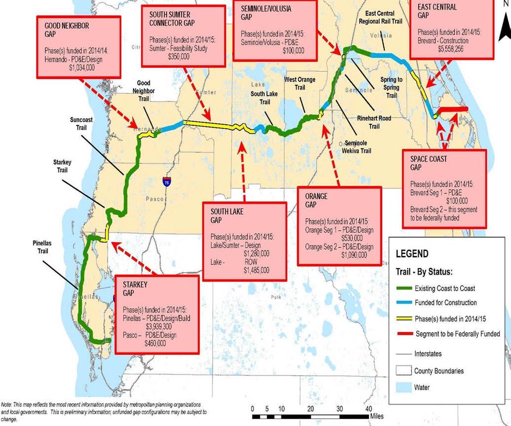
7 The Coast to Coast Connector 7
8


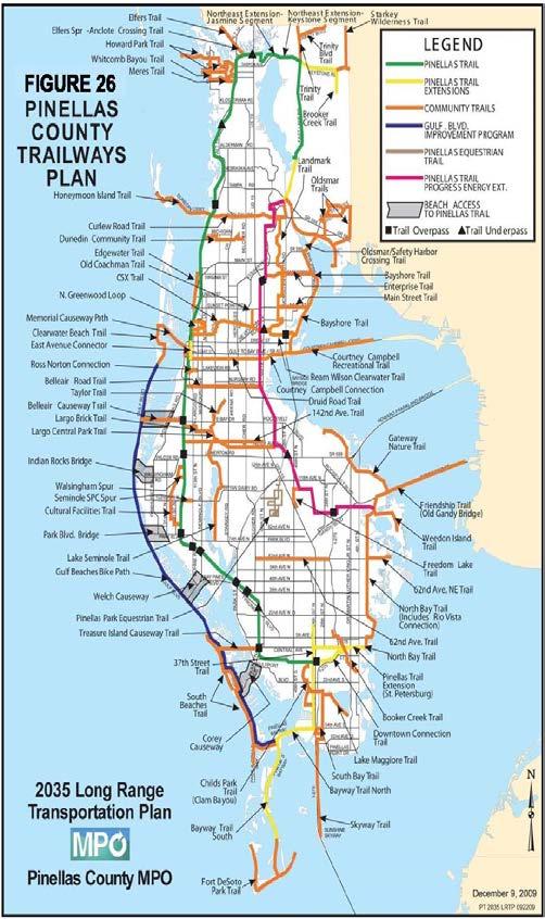
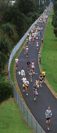
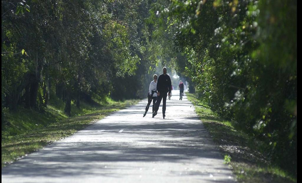
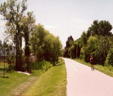
9 Fred Marquis Pinellas Trail


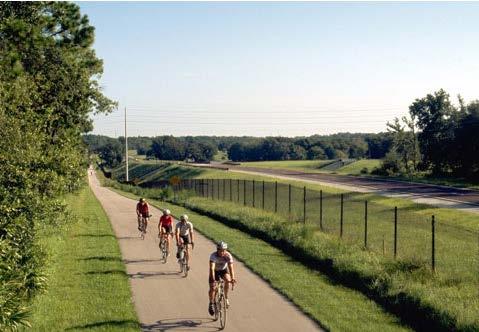
10 Coast to Coast Trail Starkey Gap Connects the Pinellas Trail to the Starkey Wilderness Trail and the Brooker Creek Preserve Future connection to Hillsborough County


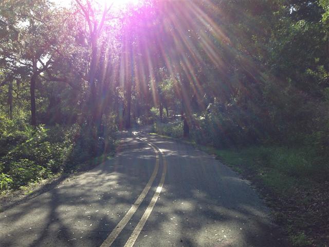
11 Coast to Coast Trail Starkey Gap Runs parallel to two-lane undivided roadway and through the Preserve.


12 Coast to Coast Trail Starkey Gap


13 Coast to Coast Trail Starkey Gap PINELLAS TRAIL AMENITIES & SERVICES Mile Marker Program Emergency Decals Pinellas Trail Security Task Force Pinellas Trails, Inc. Auxiliary Trail Ranger Volunteer Program Trail access to parks, schools, and major employment centers
14 TRI-COUNTY TRAIL (STARKEY GAP) PASCO COUNTY SEGMENT 14
15 Tri-County Trail 15
16 Tri-County Trail 16

17 Tri-County Trail Tri-County Trail 17
18 Tri-County Trail 18
")
 Connections: South Tri-County Trail")

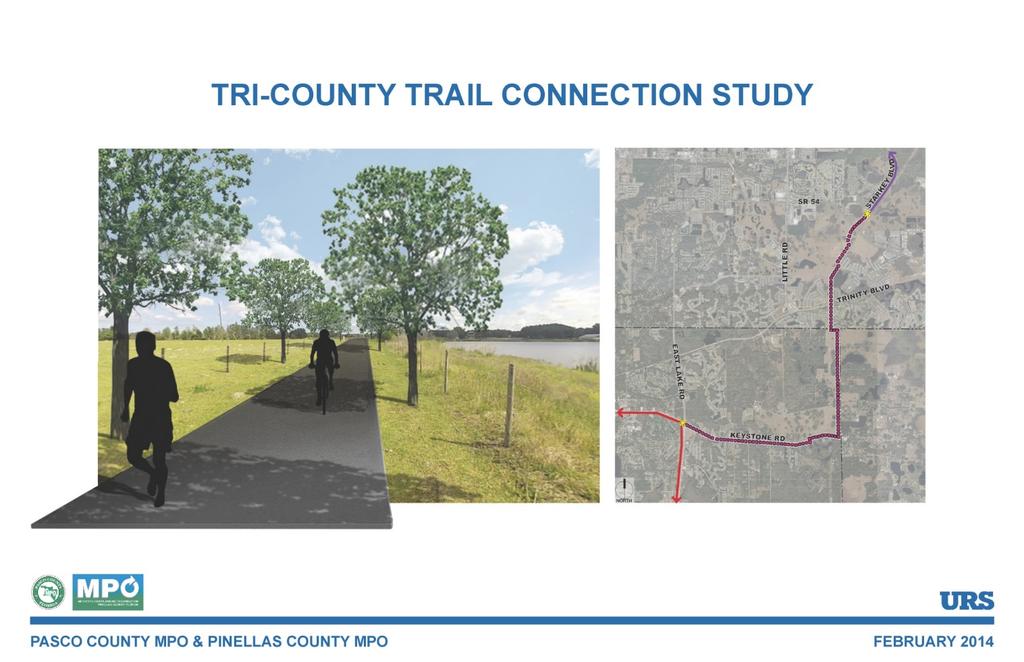
19 Tri-County Trail Length: Phase Complete: 2.39 Miles Tri-County Trail Connection Study (Route Study) Estimated Cost: Design - $460,000 Construction - $1,605,000 (unfunded) Connections: South Tri-County Trail (Pinellas Segment) Pinellas Trail North Starkey Boulevard Trail Jay b. Starkey Wilderness Trail Suncoast Trail Character: Suburban to Rural 19
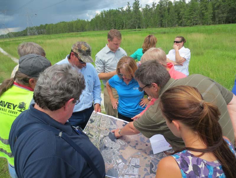
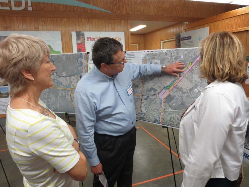
20 Tri-County Trail Site Visits Public Involvement 20
21 Tri-County Trail Connections Pasco County Segment Tri-County Trail 21
22 Tri-County Trail Issues Right-of-Way Pasco County Segment Tri-County Trail 22
23 Tri-County Trail Issues Road Crossings Pasco County Segment Tri-County Trail 23


24 Tri-County Trail Issues Trail Amenities Pasco County Segment Tri-County Trail Trail amenities will not be provided by FDOT. Local agencies must provide any amenities and coordinate with the FDOT, designers and contractors, through a Joint Participation Agreement. 24
25 Tri-County Trail 25
26 Good NEIGHBOR GAP Good Neighbor Gap

27 Good Neighbor Trail Gap
28 6 miles PD&E to begin in 2015 Estimated costs $2,001,810 for the trail plus $1.5 - $3 M for bike/ped overpass at US 41 Path to be built along south side of SR 50
29 South Sumter Connector 29
30 South Sumter Connector Alternatives Map of Trail 30
31 South Sumter Connector Part of the largest gap in the C2C Corridor Funded this year for corridor analysis and PD&E study Alternatives include potential alignment in the Withlacoochee State Forest Proposed trail would connect the Good Neighbor Trail and the Withlacoochee State Trail east to the Van Fleet Trail Alternatives could create connections to the Withlacoochee State Trail in Hernando County or Pasco County 31

32 South Sumter Connector Alternative 1 will examine a northern alignment that could connect the small municipalities of Webster and Center Hill Alternative 2 will examine paralleling SR 50 or following the historic rail bed that parallels the SR 50 corridor through the Withlacoochee Picture Location 32


33 South Sumter Connector Picture Location Picture Location 33

34 South Sumter Connector Alternatives Map of Trail 34

35 South Lake Trail / Minneola Scenic Trail 35
36 South Lake Trail / Lake Minneola Scenic Trail Map of Trail 36
37 South Lake Trail / Lake Minneola Scenic Trail West-to-East: Design funded this year from Van Fleet Trail east to Villa City Road (Mascotte/Groveland) Trail to be part of Groveland SR 50 Realignment project from Villa City Road east to Brown Road, just east of SR 33 ROW acquisition from Brown Road to the terminus of current construction Construction from Groveland to Clermont to be complete 2015 South Lake trail exists from Lakefront Park in Clermont east to the Minneola Scenic Trail 37

38 South Lake Trail / Lake Minneola Scenic Trail From Minneola Scenic Trail then C2C continues east to the South Lake Trail designation South Lake Trail east of Minneola transitions to the West Orange Trail Picture Location Lake County and cities now addressing maintenance of a decade-old trail 38


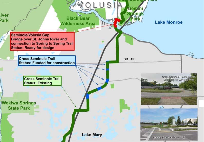
39 South Lake Trail Picture Location Picture Location 39


40 South Lake Trail / Minneola Scenic Trail Picture Location Picture Location 40

41 Picture Location Picture Location 41

42 South Lake Trail / Lake Minneola Scenic Trail Map of Trail 42
43 C2C = CoC
44 ORANGE GAP 44

45 Clarcona-Ocoee Connector 1.6 miles No phases yet completed To be programmed for PD&E and Design (combined with Pine Hills Trail Phase III) Path along Clarcona-Ocoee Road 45

46 Pine Hills Trail Phase III 2.3 miles No phases yet completed To be programmed for PD&E and Design (combined with Clarcona-Ocoee Connector) $556,000 Path along utility corridor, Beggs Road and US


47 Orange Gap Orange Gap Map of Trail 47
48 SEMINOLE GAP 48
 Right-of-way and Design complete $554,000 for")
49 Rinehart Road Path 1.1 miles (combining 5 short gaps) Right-of-way and Design complete $554,000 for construction Path along east side of Rinehart Road and north side of SR 46 49


50 Rinehart Road Path 50
51 Sumter 51
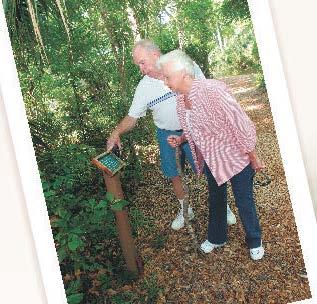
52 Lake 52

53 COAST TO COAST CONNECTOR TRAILS IN VOLUSIA COUNTY Coast to Coast Connector Summit October 1,


54 Overview In the River to Sea TPO planning area, the Coast to Coast Connector consists of the East Central Regional Rail Trail connecting Brevard and Volusia Counties (51 miles) and the Spring to Spring Trail connecting Volusia and Seminole Counties (15 miles). 54

55 Existing Conditions What has been built and can be highlighted as a success? Spring to Spring Trail Lake Monroe Park to Green Springs Park (6.7 miles) East Central Regional Rail Trail Green Springs Park to SR 415 (7.1 miles) 55

56 Status of Coast to Coast Trails in Volusia County East Central Regional Rail Trail Status: Existing 56

57 Projected Trail Alignment in Lake Monroe Park 57
58 Regional Connectivity What are the issues and opportunities for regional connectivity? Regional Trails Corridor Assessment Coast to Coast Trail Extension (Edgewater to New Smyrna Beach) SunRail Connection Public Awareness and Information Funding 58

59 Regional Trails Corridor Assessment Coast to Coast Trail East Coast Greenway Heart of Florida Trail St. Johns River to Sea Loop Project Purpose Complete the regional trails network in the R2CTPO planning area Advance the Florida Greenways and Trails System Plan Finalize alignments and connections Develop conceptual plans and cost estimates for all gap segments to compete for funding 59

60 Coast to Coast Trail Extension 60

61 SunRail Connection Utility Easement between SunRail Station and Spring to Spring Trail 61


62 Public Awareness and Information Volusia County Trails App 62

63 Coast to Coast Connector - Brevard County 63

64 Coast to Coast Connector - Brevard County SPACE COAST LOOP TRAIL 55 MILES Coast to Coast Connector St. Johns River to Sea Loop East Coast Greenway U.S. Department of Interior America s Great Outdoors Indian River National Scenic Byway America s Transportation Awards Top 10 Transportation Project 2010 Merritt Island National Wildlife Refuge Canaveral National Seashore NASA/Kennedy Space Center 64


65 East Central Florida Regional Rail Trail BREVARD COUNTY RURAL/SUBURBAN SEGMENT LENGTH: 12.8 miles PHASE: FDOT Design/Build Funded FY 2014/15 Design 2015 Construction 2016 COST: $14.3M State and Federal funding 65


66 East Central Florida Regional Rail Trail Rural Segment RURAL SEGMENT LENGTH: 5.5 miles FEATURES: Rural/wilderness trail Wetlands/ecosystems Equestrian/trailhead CHALLENGES: Emergency response Bridges/mitigation Maintenance BUDGET: $7,356,000 C2C State $ 66


67 East Central Florida Regional Rail Trail Suburban Segment SUBURBAN SEGMENT LENGTH: 7.3 miles FEATURES: Neighborhood trail Parallel but off road CHALLENGES: Road/driveway crossings Signage BUDGET: $6,946,602 FDOT work program/federal $ 67


68 East Central Florida Regional Rail Trail Titusville Segment DRAA PARK SEGMENT LENGTH: 1.4 miles PHASE: COMPLETE FEATURES: Neighborhood trail connected to future city park with full service trailhead 68


69 East Central Florida Regional Rail Trail Titusville Segment TITUSVILLE CROSSOVER SEGMENT LENGTH: 0.6 miles PHASE: Titusville Design/Build Funded FY 2014/15 Design 2015 Construction 2016 FEATURES: Pedestrian bridge across SR 406/Garden Street BUDGET: $3,631,000 FDOT work program/federal $ 69


70 Space Coast Gap Segment 1 DOWNTOWN CONNECTOR LENGTH: 1.9 miles PHASE: FDOT PD&E Funded FY 2014/15 BUDGET: $100,000 C2C State $ FEATURES: Connections to downtown, two regional parks, and future train station ISSUES: Right of way constraints 70

71 Space Coast Loop Trail Max Brewer Bridge MAX BREWER BRIDGE PHASE: FEATURES: COMPLETE Connections to two regional parks Bike/ped facilities on two sides 71


72 Space Coast Gap Segment 2 KENNEDY SPACE CENTER GAP PHASE: Feasibility Study nearing completion Next phase PD&E following federal NEPA guidelines BUDGET REQUEST: $450,000 Submitting for work program FEATURES: Proposed off road route and rail with trail through Merritt Island National Wildlife Refuge, Canaveral National Seashore, and Kennedy Space Center ISSUES: Federal funding 72

73 Coast to Coast Connector Canaveral National Seashore 73
74 Discussion Topic 1: Regional System vs. Local Trails Implementation 74


75 What makes a great regional trail? Great Planning and Design Community Development A Great Regional Trail Consists of Trail Management Economic Development 75
76 Vital Questions What does the user need and want to ensure a seamless great experience? How does that impact local implementation? What are the keys to ensuring a balance that focuses on creating a great guest experience? 76
77 What makes a great regional trail? Planning and Design Trail Management Economic Development Community Development Design and planning of trail corridors, facilities and amenities Determine signage plan Determine traffic control plan Secure acquisition funding for trails and support facilities Garner support from public and private partners Maintain trail corridors, facilities and amenities Implement signage plan Ensure trail user safety Coordinate with public and private partners Address Best Practices for potential development bordering trails Coordinate with other trails programs Cultivate relationships with local, state and federal partners Market the Trail to non-florida residents and non-trail users What impact will the Connector have on the regions health? How is the trail used to promote a healthy lifestyle? How does the trail develop a sense of community, or place? 77
78 Discussion Topic 2: Creating a Regional Leadership Structure 78
79 Coast to Coast Connector Working Group Planning and Design Community Development Working Group Trail Management Economic Development 79
80 How do we organize ourselves? 80

81 Working Group Tasks Planning and Design Trail Management Economic Development Community Development Design and planning of trail corridors, facilities and amenities Determine signage plan Determine traffic control plan Secure acquisition funding for trails and support facilities Garner support from public and private partners Maintain trail corridors, facilities and amenities Implement signage plan Ensure trail user safety Coordinate with public and private partners Address Best Practices for potential development bordering trails Coordinate with other trails programs Cultivate relationships with local, state and federal partners Market the Trail to non-florida residents and non-trail users Garner Community Support for Trail Ensure trail is used for community benefit Engage volunteers to assist in management 81


82 Working Groups Planning and Design Trail Management Economic Development Community Development FL Department of Transportation: Statewide Office FL Department of Transportation: District Offices 5 & 7 FL Department of Environmental Protection: Office of Greenways & Trails (& FGTF) City, County, or Metropolitan Planning Organizations Local, State, and Federal Trail Managers Local, State and Federal law enforcement Tourism Development Bureaus Visit Florida Local, Regional and State Government Local Depts. Of Health Community Groups Local Businesses Federal Agencies 82
83 Wrap Up 83
FY 2018/19 CENTRAL FLORIDA MPO ALLIANCE - LIST OF PRIORITY PROJECTS
 Priority FY 2018/19 CENTRAL FLORIDA ALLIANCE - LIST OF PRIORITY PROJECTS FY 2018-2019 SIS HIGHWAY PROJECTS FDOT Financial Management Number Project Name From To Work Description Latest Project Phase Funded
FUNDED FOR CONSTRUCTION
 Priority CENTRAL FLORIDA ALLIANCE 2016 SIS HIGHWAY PROJECTS FOR PRIORITIZATION FDOT Financial Project Phase(s) Estimated Management Project Name or Length Latest Project Remaining Remaining Cost Designation
2017 TBARTA Future Regional Priority Projects Adopted by TBARTA Board, December 9, 2016
 2017 TBARTA Future Regional Priority Projects Adopted by TBARTA Board, December 9, 2016 Project numbers do not signify ranking they are for mapping identification purposes only. 1. 15th Street East The
Capital City to Sea Trail (CC2ST) SUMMARY
 SUMMARY") Capital City to Sea Trail (CC2ST) So far over $24M have been invested into the Capital City to Sea Trails. o $9M-Capital Region Transportation Planning Agency (CRTPA). Master Plan/Coastal Trail (Lighthouse
Capital City to Sea Trail (CC2ST) So far over $24M have been invested into the Capital City to Sea Trails. o $9M-Capital Region Transportation Planning Agency (CRTPA). Master Plan/Coastal Trail (Lighthouse
Dr. John M. DeGrove Community Steward Webinar Series
 Dr. John M. DeGrove Community Steward Webinar Series Audio Options TO USE YOUR COMPUTER'S AUDIO: When the Webinar begins, you will be connected to audio using your computer's microphone and speakers (VOIP).
Committee. Presentation Outline
 CW-33-15 11/9/2015 Community and Corporate Services Committee November 10, 2015 1 Presentation Outline Background Vision and Objectives Study Process and Timeline Public and Stakeholder Engagement Organization
Fred Milch Project Review Manager East Central Florida Regional Planning Council
 RESHAPING THE ROLE OF PARKS, RECREATIONAL AREAS, AND GREEN SPACE TO ENHANCE LIVABILITY Fred Milch Project Review Manager East Central Florida Regional Planning Council St. Johns River to Sea Loop Webinar
Bi-County Bicycle/Pedestrian (Orange Belt) Trail PD&E Study
 Trail PD&E Study") 2018 BUILD APPLICATION Bi-County Bicycle/Pedestrian (Orange Belt) Trail PD&E Study Pasco County, FL APPLICATION INFORMATION Type of Application: Planning Study Amount Requested: $1.38 Million E XECUTIVE
2018 BUILD APPLICATION Bi-County Bicycle/Pedestrian (Orange Belt) Trail PD&E Study Pasco County, FL APPLICATION INFORMATION Type of Application: Planning Study Amount Requested: $1.38 Million E XECUTIVE
Mohawk Hudson Bike Hike Trail Crossroad Connection Study
 Summary Report - April 21, 2003 Mohawk Hudson Bike Hike Trail Crossroad Connection Study Summary Report Introduction The Capital District Transportation Committee (CDTC), in partnership with Albany County,
NEW YORK AVENUE TOWN HOME SITE
 NEW YOR AVENUE TOWN HOME SITE EXCLUSIVE LISTING DELAND, FLORIDA LOCATION The Property is located in DeLand, FL on the south side of New York Avenue (SR 44) between Frankfort Avenue on the east, Fairview
Hillsborough MPO Technical Advisory Committee. Monday, February 20, 2017
 Hillsborough MPO Technical Advisory Committee Monday, February 20, 2017 1 Study Purpose Support the vision for a livable, connected, and competitive downtown. Evaluate alternatives for the system s modernization
TBARTA: 2015 Master Plan and Tampa Bay Express Project
 TBARTA: 2015 Master Plan and Tampa Bay Express Project The Real Story Who: Tampa Bay Area Regional Transportation Authority What: Develop and implement a Regional Transportation Master Plan for the seven-county
A CASE FOR COMPLETING THE JORDAN RIVER PARKWAY: A
 A CASE FOR COMPLETING THE JORDAN RIVER PARKWAY: A safe crossing at 9000 South and 850 West Proposed 9000 South Underpass Parkway Timeline Parkway, Trail, and Tourism Facts Blueprint Jordan River 1971 1973
The Joint Charlotte County - Punta Gorda and Lee MPO Meeting has changed from 10:00 a.m. to 9:30 a.m.
 The Joint Charlotte County - Punta Gorda and Lee MPO Meeting has changed from 10:00 a.m. to 9:30 a.m. JOINT MEETING OF THE CHARLOTTE COUNTY-PUNTA GORDA METROPOLITAN PLANNING ORGANIZATION BOARD AND LEE
ANCLOTE COASTAL TRAIL ALTERNATIVES ANALYSIS STUDY
 ANCLOTE COASTAL TRAIL ALTERNATIVES ANALYSIS STUDY PASCO COUNTY MPO JULY 2015 PROJECT OVERVIEW... INTRODUCTION EXECUTIVE SUMMARY CONTEXT... TAMPA BAY AREA, PINELLAS, & PASCO COUNTY S MULTI-USE TRAIL PLANS
More than just express lanes
 A N E W C H O I C E F O R A B E T T E R C O M M U T E Tampa Bay Regional Planning Council August 8, 2016 Florida Department of Transportation, District Seven More than just express lanes ALT 19 41 581
2017 LIST OF PRIORITY PROJECTS
 0 LIST OF PRIORITY PROJECTS Adopted April, 0 Amended August, 0 by the Lake~Sumter MPO GOVERNING BOARD Coverage of Fiscal Years 0/ through 09/0 Prepared by the Lake~Sumter Metropolitan Planning Organization
PASCO COUNTY METROPOLITAN PLANNING ORGANIZATION 2016 LIST OF PRIORITY PROJECTS September 8, 2016
 PASCO COUNTY METROPOLITAN PLANNING ORGANIZATION 2016 LIST OF PRIORITY PROJECTS September 8, 2016 PROJECT SELECTION AND PRIORITIZATION PROCESS OVERVIEW HIGHWAY PROJECTS: The project selection and prioritization
Toll Rates for Florida Turnpike System and Florida Department of Transportation (FDOT) Toll Facilities. Central Florida
 Toll Facilities. Central Florida") Toll Rates for Florida Turnpike System and Florida Department of Transportation (FDOT) Toll Facilities Central Florida Effective: October 29, 20 Florida s Turnpike Northern Coin System (SR 91) Osceola,
Toll Rates for Florida Turnpike System and Florida Department of Transportation (FDOT) Toll Facilities Central Florida Effective: October 29, 20 Florida s Turnpike Northern Coin System (SR 91) Osceola,
CityStats Central Florida Trends
 CityStats Central Florida Trends 2017 Research Analyst Liane Schrader, CAE Center for Municipal Research & Innovation Florida League of Cities CityStats Central Florida Regional Trend Analysis 100% 90%
Georgetown-Lewes Rail/Trail Study. Rail/Trail Study: Cool Spring to Cape Henlopen State Park New Road Extension (House Resolution No.
 Georgetown-Lewes Rail/Trail Study Rail/Trail Study: Cool Spring to Cape Henlopen State Park New Road Extension (House Resolution No. 47) August 22, 2011 Presentation Outline Background Benefits Statewide
Regional Wayfinding Sign Strategy Thurston County Trails 2017
 Regional Wayfinding Sign Strategy Thurston County Trails 2017 Partners: Members and partnering organizations of the Thurston Thrives Community Design Action Team City of Lacey, City of Olympia, City of
AGENDA ITEM 5 D WAKULLA ENVIRONMENTAL INSTITUTE (WEI) TRAIL FEASIBILITY STUDY
 TRAIL FEASIBILITY STUDY") March 19, 2018 AGENDA ITEM 5 D WAKULLA ENVIRONMENTAL INSTITUTE (WEI) TRAIL FEASIBILITY STUDY TYPE OF ITEM: Action STATEMENT OF ISSUE The Wakulla Environmental Institute (WEI) Trail is one of several trails
March 19, 2018 AGENDA ITEM 5 D WAKULLA ENVIRONMENTAL INSTITUTE (WEI) TRAIL FEASIBILITY STUDY TYPE OF ITEM: Action STATEMENT OF ISSUE The Wakulla Environmental Institute (WEI) Trail is one of several trails
The Impact of Trails on Communities. Jim Wood Chief, Office of Greenways & Trails Division of Recreation and Parks
 The Impact of Trails on Communities Jim Wood Chief, Office of Greenways & Trails Division of Recreation and Parks Why Trails and Greenways? Resolution of the Florida Greenways and Trails Council Recognizing
Memo. Orange City Trail Plan Becky Mendez, AICP Jamie Krzeminski, PE, PTOE Matt Wiesenfeld, PE, AICP. Development of the Existing and Proposed Network
 Memo Date: Friday, December 22, 2017 Project: To: From: Subject: Trail Plan Becky Mendez, AICP Jamie Krzeminski, PE, PTOE Matt Wiesenfeld, PE, AICP Development of the Existing and Proposed Network HDR
Northaven Trail Phase 2 Initial Project Overview
 Northaven Trail Phase 2 Initial Project Overview Partnership Project to extend existing Northaven Trail Improve Bike/Ped Connectivity On Dallas Trail Network Plan City and County Funding Oncor Texas Trails
Westshore Development Forum April 9, 2014
 Florida Department of TRANSPORTATION Westshore Development Forum April 9, 2014 District Seven Secretary Paul Steinman Agenda D7 Overview Current Projects Future Projects Vision Florida Department of TRANSPORTATION
Update on Palm Beach MPO Funded Projects
 Update on Palm Beach MPO Funded Projects Presented February 3, 2016: Palm Beach Technical Advisory Committee (TAC) Citizens Advisory Committees (CAC) Tri-Rail Milestones Service began Jan 9, 1989 Double-tracking
CityStats Central Florida Trends
 CityStats Florida Trends 2018 Research Analyst Liane Giroux, CAE Center for Municipal Research & Innovation Florida League of Cities CityStats Florida Regional Trend Analysis 97% 95% 89% 89% 51% 40% Municipal
TRANSPORTATION ELEMENT
 Transportation TRANSPORTATION ELEMENT Data, Inventory, and Analysis Prepared by Contents 1.0 INTRODUCTION... 1 2.0 EXISTING CONDITIONS... 1 2.1 Roadways... 1 2.1.1 Jurisdiction... 1 2.1.2 Functional Classification...
2016 Regional Transportation Alternatives Program (TAP) Grant Application
 Grant Application") 2016 Regional Transportation Alternatives Program (TAP) Grant Application PROJECT TITLE: Yelm-Tenino Trail Extension Feasibility Study TRPC use only GENERAL PROJECT INFORMATION Agency or Organization City
2016 Regional Transportation Alternatives Program (TAP) Grant Application PROJECT TITLE: Yelm-Tenino Trail Extension Feasibility Study TRPC use only GENERAL PROJECT INFORMATION Agency or Organization City
1500+ Miles of Byways FLORIDA SCENIC HIGHWAYS PROGRAM. All-American Road. National Scenic Byways. Counties. Scenic Highways. A 20-Year Partnership
 FLORIDA SCENIC HIGHWAYS PROGRAM A Program of the Florida Department of Transportation 2016 Annual Report A MESSAGE FROM THE PROGRAM COORDINATOR Launched in July 1996, the Florida Scenic Highways Program
Florida National Scenic Trail 5-Year Strategic Plan. Barbara Bowen
 Florida National Scenic Trail 5-Year Strategic Plan 2012 Barbara Bowen Florida National Scenic Trail M. Timothy O Keefe M. Timothy O Keefe Mike Knox 20-mile Planning Corridor Florida National Scenic Trail
South Coast Greenway Trail Alignment Study Symmes Road to Adamo Drive
 South Coast Greenway Trail Alignment Study Symmes Road to Adamo Drive Prepared for: Hillsborough County Metropolitan Planning Organization 601 East Kennedy Boulevard Tampa, FL 33602 (813) 272-5940 Prepared
The Chu property is a 6.57 acre parcel located in the Town of Superior on the west side of McCaslin Boulevard. In 2014, the Town of Superior acquired
 1 The Chu property is a 6.57 acre parcel located in the Town of Superior on the west side of McCaslin Boulevard. In 2014, the Town of Superior acquired the Chu property for open space with a contribution
Section II. Planning & Public Process Planning for the Baker/Carver Regional Trail began in 2010 as a City of Minnetrista initiative.
 Section II Planning & Public Process Planning for the began in 2010 as a City of initiative. city staff began discussions with the Park District on the possibility of a north/south regional trail connection
City of Durango 5.8 FUNDING TRAILS DEVELOPMENT
 5.8 FUNDING TRAILS DEVELOPMENT The City has been successful in establishing dedicated local funding sources as well as applying for grants to develop the City s trail system, having received nearly $2.4
City Council Workshop July 26, 2010
 Des Moines Trails Connecting a Community City Council Workshop July 26, 2010 1 OVERVIEW Trail Benefits Trails Progress How We Fund Trails What s Next for Trails 2 What is a trail? Paved Trails 10 wide
Major Projects Overview
 Major Projects Overview Miami-Dade Expressway Authority February 2018 About MDX MDX operates 5 roads in Miami Dade County SR 924, SR 112, SR 836, SR 874 and SR 878 MDX Primary Source of Revenue: User Fees-Tolls
APPENDIX G MULTI-USE TRAILS DOWNTOWN LAKELAND
 MULTI-USE TRAILS DOWNTOWN LAKELAND POINCIANA PARKWAY Multi-Use Trails Trail Name From To Status Regional Network Surface Length Present Day Cost Chain-of-Lakes Trail Bridge South of US 17/92 North of US
Business Item No XXX. Proposed Action That the Metropolitan Council approve the Coon Creek Regional Trail Master Plan.
 Business Item No. 2015-XXX Metropolitan Parks and Open Space Commission Meeting date: July 7, 2015 For the Community Development Committee meeting of July 20, 2015 For the Metropolitan Council meeting
OR MISSION TRAIL ELEMENTARY
 Leawood: overview OVERLAD PARK 24: p.70 I-LA PARK 32: p.72 TOMAHAWK PARK 23: p.69 31: p.71 GEZER PARK OR MISSIO TRAIL ELEMETARY 22: p.68 W 133rd St W 135th St KASAS CITY MO - other segments Beginning/end
A Presentation to: Project Advisory Group Meeting #6
 A Presentation to: Project Advisory Group Meeting #6 March 25, 2015 Agenda Introductions Action items from last PAG meeting (February 25, 2015) Public involvement update Status of April public meetings
Update on Trinity Trails. Presented by: Richard Zavala, Director Park and Recreation Department February 7, 2017
 Update on Trinity Trails Presented by: Richard Zavala, Director Park and Recreation Department February 7, 2017 Overview Provide review of trail planning and development along the main stem Trinity River
Longmont to Boulder Regional Trail Jay Road Connection DRAFT FINAL REPORT
 Longmont to Boulder Regional Trail Jay Road Connection DRAFT FINAL REPORT December 2018 Project Summary Boulder County, Colorado, in partnership with the City of Boulder, is evaluating options for multi-use
Tallahassee-St. Marks Historic Railroad Trail
 Revitalizing a Historic Trail Designated as a National Recreation Trail, the 16-mile Tallahassee-St. Marks Historic Railroad Trail has been enjoyed by countless bicyclists, runners, and outdoor enthusiasts
Chapter 6: POLICY AND PROCEDURE RECOMMENDATIONS
 Chapter 6 POLICY AND PROCEDURE RECOMMENDATIONS FOR SRRA Below are seven policy elements that should be considered for adoption by the Southwest Regional Recreation Authority of Virginia: 1. Develop strategies
EXECUTIVE SUMMARY FALL Introduction. Findings
 EXECUTIVE SUMMARY FALL 2004 Introduction Trails are one of the most popular and highly desirable recreational resources in communities of all sizes throughout the country. In addition to providing a safe
Hillsborough County Florida Hillsborough County s Trailways Addressing Program
 Hillsborough County Florida Hillsborough County s 9-1-1 Trailways Addressing Program 2010 ProBike/ProWalk Florida -Conference May 12-13, 2010 1 REQUEST Staff from the Hillsborough County Sheriff s Office
Business Item No
 Metropolitan Parks and Open Space Commission Meeting date: February 6, 2018 For the Community Development Committee meeting of February 20, 2018 For the Metropolitan Council meeting of February 28, 2018
Basic Project Information
 FY 2015-16 PROJECT DESCRIPTION FORM (2C) Submitting Agency: Loudoun County Basic Project Information Project Title: Loudoun County Parkway (VA Route 607) U.S. 50 to Creighton Rd. (2C) Project Type (check
2.1 TITLE: VMC PARKS MASTER PLAN AND IMPLEMENTATION STRATEGY PROJECT UPDATE
 2.1 Item: VMC Sub-committee Report DATE: Tuesday, June 12, 2018 WARD: 4 TITLE: VMC PARKS MASTER PLAN AND IMPLEMENTATION STRATEGY PROJECT UPDATE FROM: Jason Schmidt-Shoukri, Deputy City Manager, Planning
Penny for Pasco Renewal. FY2014/15 thru FY2024/25
 Penny for Pasco Renewal FY2014/15 thru FY2024/25 1 Background Pasco Citizens Committee (PAC) Citizens Survey Results Coordination Activities Project Schedule Category Allocations Revenue Estimates Distribution
The Transportation Corridor Overlay District
 The Transportation Corridor Overlay District The Transportation Corridor Overlay District is a policy framework under which certain potentially beneficial development proposals may be considered, given
CREATING CONNECTIONS IN THE CITY OF NIAGARA FALLS PUBLIC MEETING DECEMBER 6, 2017
 CREATING CONNECTIONS IN THE CITY OF NIAGARA FALLS PUBLIC MEETING DECEMBER 6, 2017 CONGESTION COSTS OUR ECONOMY The average commute in Ontario is already over 45 minutes, and that figure jumps to more than
Trail Feasibility Study
 VOLUSIA COUNTY MPO CITY OF NEW SMYRNA BEACH FINAL REPORT JUNE 30, 2009 Trail Feasibility Study What s inside? 1 Introduction 2 Project Purpose & Scope 3 Physical Inventory & Assessment of Right-of- Way
// Atlanta Streetcar System Plan
 // Atlanta Streetcar System Plan Citywide Conversation April 23, 2015 4/23/2015 Atlanta BeltLine // 2015 Page 1 // Overview A Supplement to the Connect Atlanta Plan and the ABI Strategic Implementation
FEASIBILITY CRITERIA
 This chapter describes the methodology and criteria used to evaluate the feasibility of developing trails throughout the study areas. Land availability, habitat sensitivity, roadway crossings and on-street
Toll Rates for Florida Turnpike System and Florida Department of Transportation (FDOT) Toll Facilities. West Central Florida
 Toll Facilities. West Central Florida") Toll Rates for Florida Turnpike System and Florida Department of Transportation (FDOT) Toll Facilities West Central Florida Effective: October 29, 20 Veterans (SR 589) Hillsborough County Veterans SunPass
Toll Rates for Florida Turnpike System and Florida Department of Transportation (FDOT) Toll Facilities West Central Florida Effective: October 29, 20 Veterans (SR 589) Hillsborough County Veterans SunPass
Committee Report. Community Development Committee For the Metropolitan Council meeting of August 12, Business Item No.
 Committee Report Business Item No. 2015-168 Community Development Committee For the Metropolitan Council meeting of August 12, 2015 Subject: Coon Creek Regional Trail Master Plan, Anoka County Proposed
Florida Maps of Agencies' Service Delivery Areas
 Florida Maps of Agencies' Service Delivery Areas Agency for Health Care Administration: Service Areas - Alachua, Bradford, Citrus, Columbia, Dixie, Gilchrist, Hamilton, Hernando, Lafayette, Lake, Levy,
Modern Streetcar Vehicles Mixed Traffic Operations 14 Stations Scalability North and West
 February 16, 2016 Modern Streetcar Vehicles Mixed Traffic Operations 14 Stations Scalability North and West WHERE WE ARE: County s Role (5) The role of Broward County will change as a result of the transition
For Immediate Release Christine Girardin January 19, 2018 SUMTER COUNTY FLORIDA S TURNPIKE AND I-75 INTERCHANGE IMPROVEMENTS
 TRAFFIC ADVISORY For Immediate Release Christine Girardin 407-264-3069 January 19, 2018 Central and West Central Florida Weekly Lane Closures and Work Zone Advisory OCOEE Florida s Turnpike announces lane
The Future of the Road to Revolutions. A Battle Road Scenic Byway Public Forum November 9, 2010
 The Future of the Road to Revolutions A Battle Road Scenic Byway Public Forum November 9, 2010 Who is the Battle Road Scenic Byway? Four Towns: Arlington, Lexington, Lincoln, Concord Minute Man National
PREFACE. Service frequency; Hours of service; Service coverage; Passenger loading; Reliability, and Transit vs. auto travel time.
 PREFACE The Florida Department of Transportation (FDOT) has embarked upon a statewide evaluation of transit system performance. The outcome of this evaluation is a benchmark of transit performance that
County of Peterborough Active Transportation Master Plan
 The TMP developed a conceptual AT/cycling network for Peterborough County that identified both on-road and off-road (trail) AT facilities. This was a coarse network based on the existing trails and off-road
ASSESSMENT OF MULTI-USE TRAIL ACCOMMODATION
 ASSESSMENT OF MULTI-USE TRAIL ACCOMMODATION WEKIVA PARKWAY (SR 429)/SR 46 REALIGNMENT PD&E STUDY Orange, Lake, and Seminole Counties, Florida Financial Project ID: 238275 1 22 01 and 240200 1 22 01 Federal
COPPER HERITAGE TRAIL CONCEPTUAL PLAN 2011
 COPPER HERITAGE TRAIL CONCEPTUAL PLAN 2011 A Proposed 40 Mile Non-Motorized Rail Trail Route Connecting The Historic Communities Of the Copper Country Prepared For: Western Upper Peninsula Health Department
FY Annualized. FY Annualized
 REVENUE ESTIMATING CONFERENCE TAX: Stormwater Fees ISSUE: Stormwater Fees for Agricultural Lands BILL NUMBER(S): HB 1197 enrolled Sec 1 SPONSOR(S): State Affairs Committee; Representative Horner MONTH/YEAR
West Orange Trail. Clean, Green, Fun!
 West Orange Trail Clean, Green, Fun! The West Orange Trail - when completed - will be a 36-mile, multipurpose recreational greenway containing a 14-foot wide paved surface to be enjoyed by walkers, joggers,
Welcome to the Downtown Fort Lauderdale Neighborhood Working Group Meeting. First meeting june 17, 2010
 Welcome to the Downtown Fort Lauderdale Neighborhood Working Group Meeting First meeting june 17, 2010 State of the Project Draft Environmental Impact Statement Study Phase This study is NOT the final
RUSHMORE CONNECTOR TRAIL PROPOSAL
 PURPOSE AND NEED Background The U.S. Forest Service, Black Hills National Forest (Forest Service) has received a special use permit application from the State of South Dakota Department of Game, Fish and
Trail # NW Tuesday, June DESIGN. Provide an Review the Provide an. Project Goals: System system. wayfinding
 I. Welcome / Introductions Bethany Creek Trail #2 Segment 3 Neighborhood Meeting #1 Bethany Presbyterian Church 15505 NW Springville Road, Portland, OR 97229 Tuesday, June 26, 2018 @ 6:00PM Meeting Minutes
Update of MDX Open Road Tolling
 Update of MDX Open Road Tolling Citizens Transportation Advisory Committee September 11, 2013 About MDX MDX is an agency of the state created by the State Legislature and the County Commission to assure
A VISION FOR EL MIRAGE
 el mirage A VISION FOR EL MIRAGE OASIS, ARIZONA A thriving desert jewel destination with a strong arts district, high-wage employment parks system joined together by cohesive, multi-use accessible trails
DEVELOPMENT LAND FOR SALE
 Lake Louisa 51± Planned Commercial 249± acres Proposed Wellness Center 152± acres Proposed 600 Single-Family Lots FOR SALE: 44± acres Planned Commercial/ Multi-Family FOR SALE: 231± gross acres (120± net
4.19 Parks, Recreation, and Conservation Lands
 interchange would have on the Reed Paige Clark Homestead located on the north side of Stonehenge Road. Alternative D would also affect Palmer Homestead, E.F. Adams House, and Knapp Brothers Shoe Manufacturing
National Society of Professional Engineers. Charles S. Carnaggio, PE Project Director July 2, 2014
 National Society of Professional Engineers Charles S. Carnaggio, PE Project Director July 2, 2014 Phase 1 Opening Date: July 26, 2014 Dulles Corridor Metrorail Project At-a-Glance Seamless integration
DEVELOPMENT LAND FOR SALE
 centrally LOCATED! Minutes from WALT DISNEY WORLD! Lake Louisa INCREDIBLE LOCATION Located on east side of US 27 approx. 2 miles south of Clermont in Lake County, FL. SIZE 721± acres Seller will divide.
JOSLIN FIELD, MAGIC VALLEY REGIONAL AIRPORT DECEMBER 2012
 1. Introduction The Federal Aviation Administration (FAA) recommends that airport master plans be updated every 5 years or as necessary to keep them current. The Master Plan for Joslin Field, Magic Valley
BACKCOUNTRY TRAIL FLOOD REHABILITATION PROGRAM
 BACKCOUNTRY TRAIL FLOOD REHABILITATION PROGRAM Backcountry Trail Flood Rehabilitation A June 2013 Flood Recovery Program Summary In June 2013, parts of Southern Alberta were devastated from significant
DRAFT - APRIL 13, 2007 ROUTING STUDY FOR TRAIL CONNECTIONS BETWEEN CALAIS AND AYERS JUNCTION
 DRAFT - APRIL 13, 2007 ROUTING STUDY FOR TRAIL CONNECTIONS BETWEEN CALAIS AND AYERS JUNCTION Abstract The vision for the East Coast Greenway is an off-road urban trail system running from Calais, Maine
Committee Report. Community Development Committee For the Metropolitan Council meeting of April 13, Business Item No.
 Committee Report Business Item No. 2016-48 Community Development Committee For the Metropolitan Council meeting of April 13, 2016 Subject: Harriet Island-South St. Paul Regional Trail Master Plan, Saint
MARTA & City of Atlanta Sales Tax Referendums. Public Hearings May 25 & 26, 2016 June 1 & 2, 2016
 MARTA & City of Atlanta Sales Tax Referendums 1 MARTA & City of Atlanta Sales Tax Referendums Public Hearings May 25 & 26, 2016 June 1 & 2, 2016 MARTA & City of Atlanta Sales Tax Referendums 2 Guiding
MASTER PLAN EXECUTIVE SUMMARY
 Biscuit Run State Park Scottsville Road (State Route 20) Charlottesville, VA 22902 Biscuit Run State Park MASTER PLAN EXECUTIVE SUMMARY Department of Conservation and Recreation Division of Planning and
The Vision for the San Juan Islands Scenic Byway
 The Vision for the San Juan Islands Scenic Byway 2 Judd Cove, Orcas Island, Courtesy of Kurt Thorson (kurtthorson.com) and San Juan County Land Bank Vision for the San Juan Islands Scenic Byway The San
Lafourche Parish Government REQUEST FOR QUALIFICATIONS. Landscape Architectural Services
 Lafourche Parish Government REQUEST FOR QUALIFICATIONS Landscape Architectural Services Bayou Lafourche Parish Multi-Use Path Feasibility Study Phase 1 And Bayou Lafourche Parish Multi-Use Path Feasibility
AUGUST 5, 2010 UPDATE # 3 AMTRAK/FEC PROJECT: STATION LOCATIONS AND CONCEPTUAL DRAWINGS
 AUGUST 5, 2010 UPDATE # 3 AMTRAK/FEC PROJECT: STATION LOCATIONS AND CONCEPTUAL DRAWINGS The Summer of 2010 has been a time of tremendous progress for the Amtrak/FEC Corridor project and its goal of restoring
Predictive Economic Impact Study for the Mount Dora to Seminole Wekiva Trail
 Predictive Economic Impact Study for the Mount Dora to Seminole Wekiva Trail Prepared By: Valerie Seidel vseidel@balmoralgroup.us 341 N. Maitland Ave., Suite 100 Maitland, FL 32751 Phone (407) 629-2185
ORANGE COUNTY TRANSPORTATION AUTHORITY. Go Local Fixed-Guideway Program History and Project Update. PowerPoint 3
 ORANGE COUNTY TRANSPORTATION AUTHORITY Go Local Fixed-Guideway Program History and Project Update PowerPoint 3 Santa Ana-Garden Grove Fixed Guideway Project OCTA Board of Directors September 26, 2011 Project
MEETING MINUTES District 1 Trail Planning Meeting 1
 MEETING MINUTES District 1 Trail Planning Meeting 1 June 1, 2017 2:00 PM 3:30 PM City of Two Harbors 2:00 Introductions Attendees: Lisa Austin, MnDOT Bryan Anderson, MnDOT Jasna Hadzic-Stanek, MnDOT Justin
1.2 Corridor History and Current Characteristics
 SECTION 1 Description and Background of Study Area 1.1 Introduction This preliminary engineering report was prepared for the Alaska Department of Transportation and Public Facilities (ADOT&PF). It is part
Hudson Highlands Fjord Trail Draft Master Plan. April 29, 2015
 Hudson Highlands Fjord Trail Draft Master Plan April 29, 2015 Agenda Route Overview Proposed Segment Results of Community Survey on that Segment Next Steps Municipal Endorsement Environmental Review Implementation
EL PASO COUNTY REGIONAL TRANSIT INSTITUTIONAL OPTIONS ASSESSMENT STUDY
 EL PASO COUNTY REGIONAL TRANSIT INSTITUTIONAL OPTIONS ASSESSMENT STUDY Sponsored by: El Paso County Funding Support: Texas Department of Transportation Technical Assistance to the County: Texas A&M Transportation
FLL Master Plan Update Technical Advisory Committee (TAC) Briefing #1. September 28, 2016
 Briefing #1. September 28, 2016") FLL Master Plan Update Technical Advisory Committee (TAC) Briefing #1 September 28, 2016 TAC Committee Role: Internal Stakeholders To provide input on the master planning analysis from the technical and
FLL Master Plan Update Technical Advisory Committee (TAC) Briefing #1 September 28, 2016 TAC Committee Role: Internal Stakeholders To provide input on the master planning analysis from the technical and
NORTHEAST CARLTON COUNTY BICYCLE ROUTE PLAN
 NORTHEAST CARLTON COUNTY BICYCLE ROUTE PLAN 5/31/2014 and St. Louis River Trail Plan Update Produced by the Arrowhead Regional Development Commission (ARDC) in Partnership with the State Health Improvement
Central Broward Transit (CBT) Phase 1 Public Open House January 21, 2016
 Phase 1 Public Open House January 21, 2016") Central Broward Transit (CBT) Phase 1 Public Open House January 21, 2016 CBT Phase 1/Wave Extensions AGENDA What is the CBT Phase 1 Project? Who are the Project Partners? Where is the Project Located?
Central Broward Transit (CBT) Phase 1 Public Open House January 21, 2016 CBT Phase 1/Wave Extensions AGENDA What is the CBT Phase 1 Project? Who are the Project Partners? Where is the Project Located?
Working Towards Sustainable Tourism in England s AONBs
 Working Towards Sustainable Tourism in England s AONBs Purpose: this Accord sets out a shared vision for tourism in England s Areas of Outstanding Natural Beauty (AONBs) and outlines the contribution that
SECTION 106 ACTIVITIES ANNUAL REPORT
 SECTION 106 ACTIVITIES ANNUAL REPORT FOR THE YEAR ENDING DECEMBER 31, 2011 Metropolitan Washington Airports Authority 1593 Spring Hill Road, Suite 300 Vienna, Virginia 22182 JANUARY 2012 Introduction The
Salmon Valley Trails Action Plan
 Salmon Valley Trails Action Plan Updated Spring 2017 i ACKNOWLEDGMENTS The following people contributed to the development of this plan: Rachel Layman, Salmon Valley Stewardship (Project Coordinator) Toni