NORTHEAST CARLTON COUNTY BICYCLE ROUTE PLAN
|
|
|
- Holly Wiggins
- 5 years ago
- Views:
Transcription


1 NORTHEAST CARLTON COUNTY BICYCLE ROUTE PLAN 5/31/2014 and St. Louis River Trail Plan Update Produced by the Arrowhead Regional Development Commission (ARDC) in Partnership with the State Health Improvement Program (SHIP), Minnesota s Lake Superior Coastal Program, the City of Cloquet and the Cloquet area Chamber of Commerce Trail Committee.


2 Plan Funders: Minnesota s Lake Superior Coastal Program City of Cloquet Carlton County Cloquet Area Chamber of Commerce Arrowhead Regional Development Commission This report was funded in part by the Coastal Zone Management Act of 1972, as amended, by NOAA s Office of Ocean and Coastal Resource Management, in conjunction with Minnesota s Lake Superior Coastal Program.
3 S T. L O U I S R I V E R T R A I L P L A N U P D A T E SUMMARY The communities of northeast Carlton County have a strong commitment to providing citizens and visitors with safe, convenient, and scenic options for walking and bicycling for both transportation and recreation. The Northeast Carlton County Bicycle Route Plan takes that commitment another step forward by identifying connections between existing facilities that make active transportation and recreation available to all area neighborhoods. The Plan makes seven recommendations for improvements in Thomson Township, Scanlon, Cloquet s Community Core, Big Lake Road area, Fond du Lac Reservation, South Cloquet Area and North Cloquet Area. Recommendations include route signage, new paved trails, policy changes, and road shoulder widening.

4 BACKGROUND Northeast Carlton County consists of the Cities of Carlton, Cloquet, Scanlon, Thomson, and Wrenshall, the Fond du Lac Reservation, and the Townships of Thomson (Esko), Perch Lake, and Twin Lakes. The total population of this area is over 25,000 residents. The area is bicycle oriented-the Willard Munger State Trail, a paved trail connecting nearby Duluth, Minnesota to Hinckley, Minnesota (63 miles), is a popular centerpoint for the region. The communities of northeast Carlton County have long advocated for direct and safe bicycle access to the trail from their homes and businesses. In 2005, the Arrowhead Regional Development Commission (ARDC) published the St. Louis River Trail Plan. That plan proposed a paved, non-motorized trail connecting the Willard Munger State Trail to the City of Cloquet through the Cities of Carlton and Scanlon. The trail was shown as roughly paralleling the St. Louis River. The first phase of the trail has been constructed. From south to north, it passes through Carlton neighborhoods, then passes through a scenic forested area and terminates at a parking lot just off of Interstate 35 and just south of Scanlon. The lot is known as the Scanlon Park and Ride. The other phases of the project have not been constructed. A safe, efficient, and cost effective alignment through the Scanlon commercial district and along the river has not been identified. Other ideas for alignments have not moved forward due to cost and easement concerns. Meanwhile, other trail initiatives in the area have moved forward. A paved trail to the east, in Esko along County Highway 61 is set to be constructed this summer (2013). A paved trail to the west, along Big Lake Road from Cloquet to the Fond du Lac Tribal facilities, is being constructed in The Cloquet Area Chamber of Commerce determined an update of the St. Louis River Trail Plan is needed and held a Trail Committee meeting in April The Committee asked ARDC to develop a scope of work outlining a planning process that can move bicycle connections forward in northeast Carlton County. Due to the other trail initiatives and the constraints on completing the St. Louis River Trail as originally proposed, ARDC proposes that a larger examination of bicycle potential in the area; not just an update to the St. Louis River Trail Plan should occur. Page 1

5 PLANNING PROCESS ARDC worked with the Cloquet Area Chamber of Commerce Trail Committee throughout the planning process. At each monthly meeting, ARDC staff presented information about the local trail system and potential improvements. Meeting participants provided feedback on ideas, clarified projects within their jurisdictions, and suggested the next steps to be completed in the process. This document was developed as the process moved along and was presented as a draft in April Following that meeting site visits were held to each proposed project location. After changes were made, ARDC developed an implementation checklist for the stakeholders to follow and use when working to meet the goals of this process. Concurrently, the City of Cloquet is completing an update of their Comprehensive Plan s transportation chapter. The Trail Committee decided to wait to present the final draft of this plan until the public meetings are held regarding the transportation chapter. The committee felt that this process and the transportation chapter update process were very closely aligned and that it was likely the recommendations from this document would be folded directly into the update. Therefore these recommendations will be publicly vetted as part of the transportation chapter update s extensive public input process. Process Participants City of Cloquet City of Scanlon Thomson Township Carlton County Fond du Lac Tribe Cloquet Active Transportation Coalition Cloquet Area Chamber of Commerce Trail Users/Stakeholders Page 2
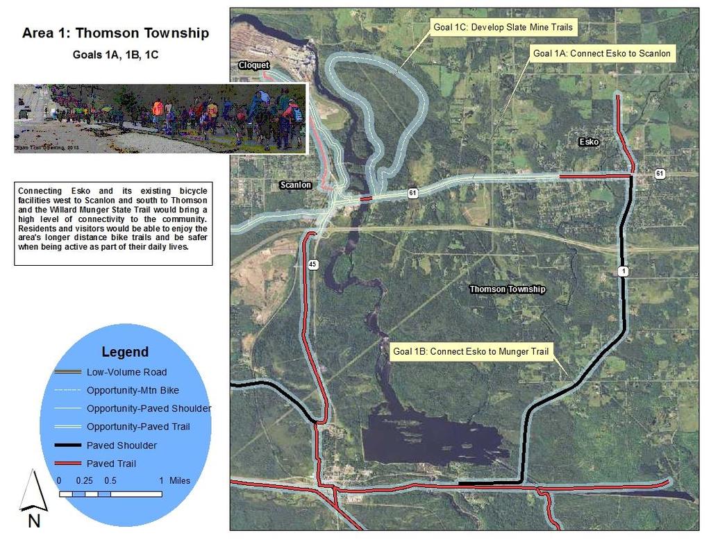
6 RECOMMENDATIONS Area 1: Thomson Township (Esko) The community of Esko, in Thomson Township, surrounds the intersection of Carlton County Highways 1 and 61. The community has a school and some businesses. A. Connect Scanlon to Esko There is currently a paved off road trail going north from the 1/61 intersection to the school s ball fields and sports facilities. There is also a paved trail paralleling Highway 61 between Highway 1 and Maple Drive. Thomson Township and Carlton County have applied for funding to extend that trail about another mile west. The Highway 61 bridge over the St. Louis River on the Township s far west side has a separated facility on it south side for bikes and pedestrians, but is not connected to any off road trails. This plan recommends that the communities in northeast Carlton County continue to seek a paved trail connector between Scanlon and Esko. A route continuing the existing 10 foot wide paved trail in Esko extending west on the south side of Highway 61 would be preferred, as it could take advantage of the separated bridge facility near Scanlon. This new trail would need safe passage through Scanlon in order to connect to Cloquet, Fond du Lac, and Carlton (See Area 2 recommendations). Summary: Goal: Connect Esko to Scanlon Reasoning: Connecting two population centers, where people work and shop, and where schools are located is a priority for bicycle connectivity Existing facilities: Approximately one mile of paved, off road trail is constructed, another ½ mile is proposed and funding is currently being sought; separate lane for bikes and peds is in place across St. Louis River Needed improvements: Construction of the remainder of the paved, off road trail between Scanlon and Esko, on the south side of Highway 61, within Carlton County right of way. Distance: 2.2 miles Construction Cost: $900,000 Design and Engineering Cost: $135,000 Page 3
7 B. Connect Esko to Thomson and the Munger Trail County Highway 1 directly connects the City of Thomson and the community of Esko. It is a fairly busy roadway with a wide shoulder and an overpass and interchange with Interstate 35. Thomson is bisected by the Willard Munger State Trail, a former railroad bed that is now a paved, off road trail. The Munger connects northeast Carlton County with Duluth. This plan recommends that Highway 1 between Esko and Thomson be maintained as a bike route. It should be signed as a bike route and the shoulder s pavement should be kept in good repair. It is an important route connecting users to the popular Munger Trail. It also could be a part of a long loop connection Esko to Carlton, Carlton to Scanlon, and Scanlon back to Esko. Route Statistics: Goal: Connect Esko to Thomson and Munger Trail Reasoning: Connecting the population center of Esko to the Willard Munger State Trail opens the community to a major biking destination and multiple route opportunities Existing facilities: There is a paved shoulder on much of Highway 1 between Thomson and Esko, but it may be rough and deteriorated in some areas Needed improvements: The route may need pavement work and signage may need to be increased and improved Distance: 4.1 miles Construction Cost: $284,000 Design and Engineering Cost: $42,600 C. Support Future Development of Slate Mine Trails At the west edge of Thomson Township, on the east bank of the St. Louis River, is property that is owned by Minnesota Power, the entity that operates the River s dams and hydroelectric facilities, and Sappi Paper, who owns the nearby paper manufacturing facility. The site is home to some closed slate mine pits. The property has no current use or development and it will remain that way unless air quality restrictions are lifted. This plan recommends that action be taken to remove the site from use restrictions when the air quality conditions allow it. Use of the site for recreation can be examined at that time. A paved trail and/or a series of mountain bike trails may be an appropriate use. Page 4
8 Page 5
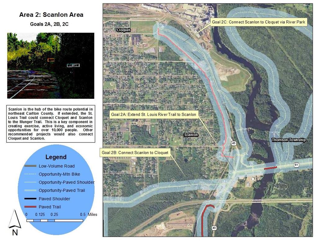
9 Area 2: Scanlon/Tall Pine Lane/St. Louis Trail Area The City of Scanlon has a commercial center on Highway 45 just north of Interstate 35. These businesses include taverns, restaurants, gas stations/convenience stores, and some auto/truck related facilities. The BNSF railroad bisects the City, cutting off most residences from the commercial area and from the Scanlon River Park recreation site. A. Extend St. Louis Trail north of Interstate 35 to the intersection of County Highway 45 and County Highway 61, and to Scanlon River Park. The St. Louis River Trail is a paved off road facility that connects the City of Carlton and the Willard Munger State Trail to the park and ride lot on the south side of Interstate 35 at Highway 45. The St. Louis River Trail Plan calls for the trail to extend into Scanlon and Cloquet. That has yet to be realized. The area between the park and ride lot and the traffic signals at the intersection of Highways 61 and 45 is quite congested with businesses that have a motor vehicle focus (many driveways/accesses on Highway 45) and the underpass of Interstate 35 by Highway 45 is narrow and offers very little room for bikes and peds. This creates a difficult situation in which to fit in a 10 foot wide off road paved trail. This plan recommends that the northeast Carlton County communities collaborate on a design project that does an in-depth examination of the area between the park and ride and the 45/61 intersection. This process would utilize existing right of way mapping, public input, business input, and City input to find a usable route for the trail. It would also examine non-trail options such as widened shoulders/bike lanes. The information from this design process will drive the pursuit of construction funding. The design process could also determine the feasibility and design for a potential new road crossing of the BNSF railroad at Tall Pine Lane. The design would look at interpretive possibilities at the site of Scanlon's first lumber mill and could determine if a tunnel under County Highway 45 to Scanlon River Park is at all feasible. Page 6
10 Primary Recommendation: Complete design project to determine potential route and feasibility of extending the St. Louis River Trail to the 45/61 intersection, Scanlon River Park, and Tall Pine Lane. Route Statistics: Goal: Connect Scanlon commercial area to the St. Louis River Trail Reasoning: Scanlon has several hospitality businesses that could benefit from a direct connection to the Trail. Existing facilities: St. Louis River Trail to Scanlon Park and Ride, traffic signal at 61 and 45 Needed improvements: Construction of a paved off road trail or designated bike lanes on Highway 45 Distance: 0.4 miles Construction Cost: $225,000 Design and Engineering Cost: $33,750 Goal: Connect St. Louis River Trail to Scanlon River Park Reasoning: Scanlon River Park is a natural amenity that is underutilized by the community and serves as a natural corridor to Cloquet. Existing facilities: Traffic signal at 61 and 45 Needed improvements: Construction of a paved off road trail or designated bike lanes on Highway 61 to Scanlon River Park entrance Distance: 0.18 miles Construction Cost: $81,000 Design and Engineering Cost: $12,150 Alternate Option: Bore a tunnel for the trail connection under County Highway 45 to Scanlon River Park Existing facilities: High grades on County Highway 45 due to railroad bridge Needed improvements: Construction of a paved off road trail and tunnel Distance: 0.21 miles Construction Cost: $700,000 Design and Engineering Cost: $105,000 Page 7
11 B. Examine the opportunity to develop Tall Pine Lane through Scanlon between Highway 45 and 22 nd Street as a roadway that accommodates bicycles at a high level (either a separate facility in the corridor or using striping and signage) and as a paved off road bicycle trail in Cloquet between 22 nd Street and 14 th Street. Tall Pine Lane is a corridor that is an unimproved road or just empty right of way that extends across the south side of Scanlon and the Cloquet core. The right of way includes properties on both the east and west sides of the BNSF railroad in Scanlon s commercial area. The Scanlon Comprehensive Plan calls for the City to examine the possibility of building a new roadway for Tall Pine Lane. The roadway would start at Highway 45 heading west, make a new crossing of the BNSF Railroad, and follow the existing Tall Pine right of way to the Scanlon city limits at 22 nd Avenue. An off road trail or designated bike lanes, along with sidewalks, could be part of the roadway design. Moving west into Cloquet, an off road paved trail could be built in the right of way, connecting to 14 th Avenue, a proposed bike route. There is an existing underutilized railroad crossing in Scanlon that could be closed if a new crossing is constructed. This plan recommends that the Tall Pine Lane idea be part of the design process recommended in Section D. This process will inform the communities about the idea s feasibility, route, and potential cost. Route Statistics: Goal: Connect Scanlon and Cloquet to each other and the St. Louis River Trail Reasoning: Safer, dedicated bike and ped facilities are needed between Scanlon and Cloquet, currently there are major barriers between the communities-this connection will also facilitate a safer connection to the St. Louis River Trail, Esko, Carlton, and the Willard Munger State Trail Existing facilities: right of way, rough roadway Needed improvements: Road construction, bike facility construction, sidewalk construction, bike trail construction, and railroad crossing construction Trail Distance: 0.5 miles Construction Cost: $225,000 Design and Engineering Cost: $33,750 Road Construction Distance: 0.6 miles Construction Cost: $3,992,180 Design and Engineering Cost: $589,827 Page 8

12 C. Extend St. Louis River Trail through Scanlon River Park and to Cloquet. On the west side of the St. Louis River in Scanlon is a wooded area with a non-motorized boat landing, a parking area, and a fishing pier. The site also has a cleared corridor running through it that is the path of a wastewater pipeline. The site is owned by Minnesota Power, who has a dam there. The site is referred to as Scanlon River Park. The park has a nice location and is generally underutilized. The original St. Louis River Trail Plan showed a potential trail corridor going through the park on or near the pipeline corridor, then crossing the BNSF railroad before paralleling Highway 45 into Cloquet s downtown. This plan continues that recommendation. This plan also recommends that the design of the trail and potentially other facilities in the park be part of the design process recommended in Sections D and E. This process will generate ideas for improving the value of the park to the community and will determine the feasibility and potential cost of a trail through the site. Route Statistics: Goal: Connect Scanlon River Park to Scanlon and Cloquet, connect Cloquet to St. Louis River Trail Reasoning: Scanlon River Park is underused natural resource in a scenic location and there are safety barriers for peds and bikes wishing to access it; Cloquet would benefit from a connection to the St. Louis River Trail Existing facilities: Parking lot, non-motorized boat access, cleared pipeline corridor Needed improvements: Trail through park, railroad bridge or tunnel, additional trail to Cloquet s downtown Distance: 1.7 miles Construction Cost: $956,400 Design and Engineering Cost: $143,460 Page 9
13 Page 10
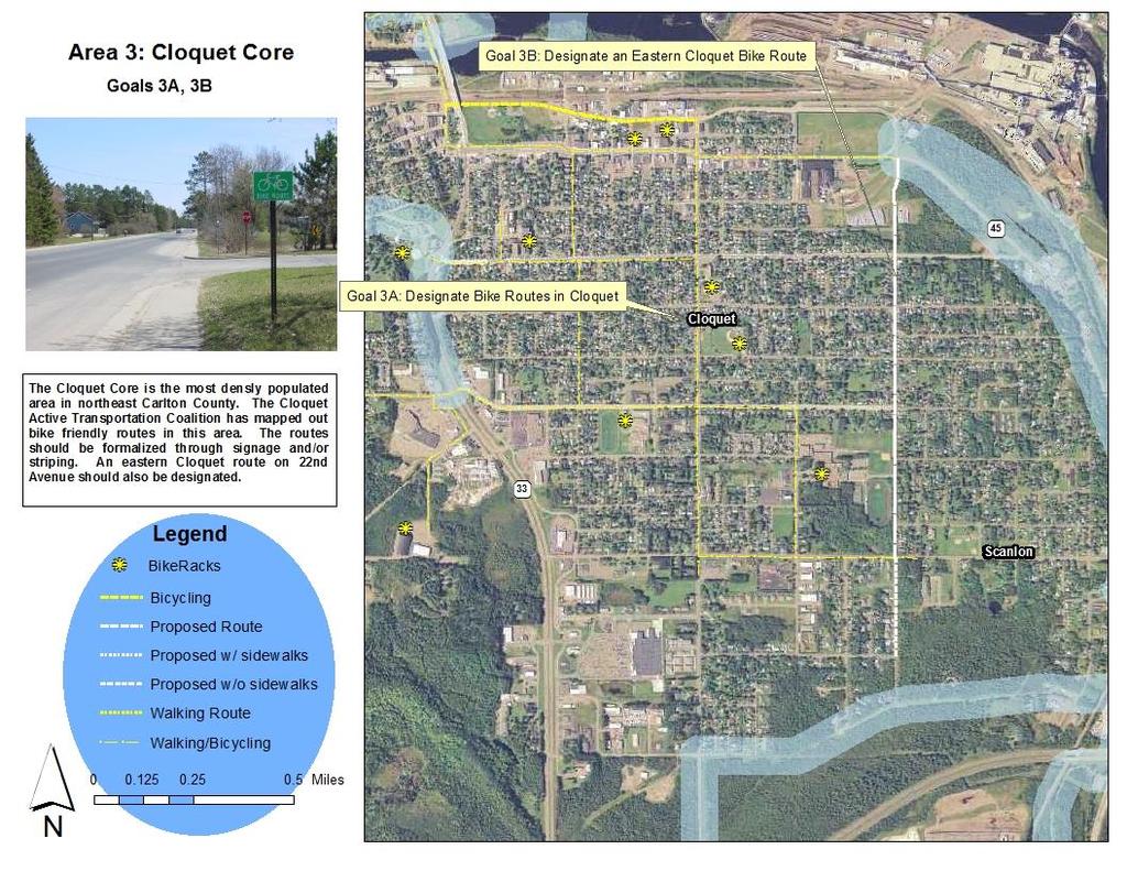
14 Area 3: Cloquet Community Core The City of Cloquet covers several square miles and has two distinct areas, the central core that is the location of most of the City s residences, community facilities, and businesses. This plan calls this area the Community Core. The Cloquet Active Transportation Coalition is a group dedicated to improving active living opportunities in Cloquet. That group has published a map of preferred routes for walking and biking in the Community Core. A. Maintain and sign the bicycle routes promoted by the Cloquet Active Transportation Coalition and shown on their community walking and biking map. The Coalition s maps show preferred routes. The community should strengthen those designations by signing the routes and striping them where feasible. Route Statistics: Goal: Formalize the bike route system in Cloquet to ensure its continued use and designation Reasoning: Having promoted routes will create more community awareness of biking and walking opportunities and will enhance safety Existing facilities: Maps Needed improvements: Signage and striping Distance: Construction Cost: Design and Engineering Cost: Page 11
15 B. Add an on-street bike route on the eastern portion of Cloquet and the western edge of Scanlon. Including 22 nd Street in the bike network would accommodate this connection and would be a good connection to the potential Tall Pine Lane route. Adding the east portion of Carlton Avenue to the network would also help connectivity. Route Statistics: Goal: Ensure eastern Cloquet and western Scanlon are served by the bike route system Reasoning: Providing walking and biking opportunities in the eastern area of Cloquet and its important destinations (school, Scanlon community center) is important Existing facilities: (NOT SURE) Needed improvements: signage, striping, sidewalks? Distance: 1.6 miles Construction Cost: $183,150 Design and Engineering Cost: $27,470 Page 12
16 Page 13
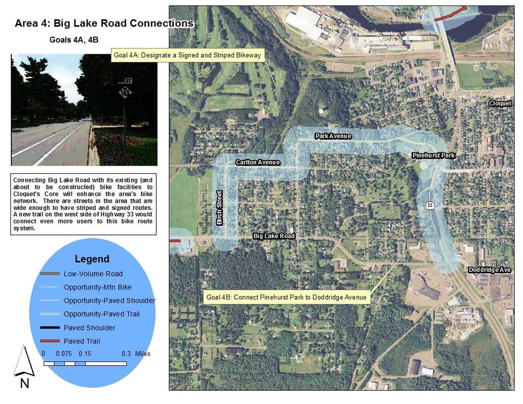
17 Area 4: Big Lake Road Connections A. Connect Big Lake Road to Pinehurst Park and Carlton Avenue in Cloquet Big Lake Road is the main route between the Cloquet Community Core and the facilities of the Fond du Lac Tribe. The Tribe has constructed a short off road paved trail along Big Lake Road near its community store, and the tribe will be extending that trail all the way to the Tribal headquarters in the summer of This plan recommends developing a connection between the terminus of the Tribe s trail and downtown Cloquet. Big Lake Road has wide shoulders that can be used (parking could be eliminated and lanes could be striped) from the trail terminus east to Balsam Street. From there, a signed and striped route going north on Balsam, then east on Carlton Avenue, then north and east on Park Avenue would get users to Pinehurst Park. These roads generally have wide surfaces and sidewalks. The route would pass by a playground at Laurel and Carlton as well. Route Statistics: Goal: Connect Fond du Lac Tribal facilities and western Cloquet to Cloquet s parks, schools, and downtown Reasoning: This would connect two major destinations (Big Lake Road Trail and Pinehurst Park) and would provide a safe alternative to the narrow east end of Big Lake Road and busy Highway 33. Existing facilities: Trail from Cloquet to Fond du Lac, green spaces, right of way Needed improvements: Signage and striping, parking elimination, trail construction Distance: 0.6 miles Construction Cost: $225,000 Design and Engineering Cost: $33,750 Page 14
18 B. Connect Pinehurst Park to Doddridge Avenue Pinehurst Park is a major destination for people seeking recreation. The Doddridge Avenue area is a major retail and hospitality business area. A pedestrian facility between the two areas would be beneficial, particularly after the major pedestrian safety issues at Doddridge are addressed in a 2014 construction project. Route Statistics: Goal: Connect busy Pinehurst Park to a major commercial area and south Cloquet residences Reasoning: Both locations would be major destinations for walkers Existing facilities: Highway 33 corridor Needed improvements: Sidewalk or off road trail construction along Highway 33, most likely on the west side of the roadway. Distance: 0.4 miles Construction Cost: $60,150 (sidewalk) Design and Engineering Cost: $9,022 Page 15
19 Page 16
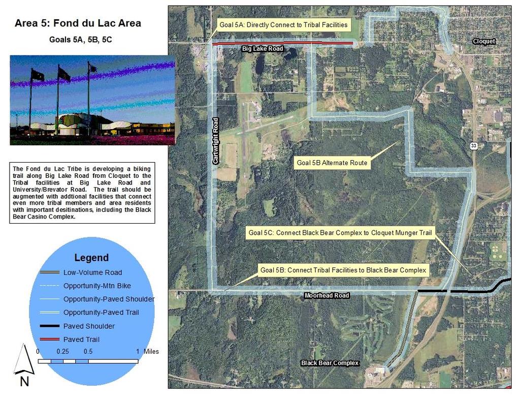
20 Area 5: Fond du Lac Tribal Facilities The Fond du Lac Tribe has government centers, housing areas, and Black Bear Casino Resort under its jurisdiction on the western edge of Cloquet. The facilities are somewhat spread out over the area. A. Connect Big Lake Road Trail to additional tribal facilities The Fond du Lac Tribal complex on Big Lake and University Roads, includes government facilities, schools, and health sites. The trail along Big Lake Road will terminate at the University Road intersection. This plan recommends extending the trail that is set to be constructed in 2014 to connect with the key destinations of the complex. Route Statistics: Goal: Directly connect trail users to tribal facilities Reasoning: Providing direct connections will enhance safety for bikes and peds Existing facilities: Trail to be built in 2014, Tribal facilities Needed improvements: Trail construction Distance: 0.6 miles Construction Cost: $225,000 Design and Engineering Cost: $33,750 Page 17
21 B. Connect Tribal Headquarters to Black Bear Casino Resort Black Bear Casino Resort is a major facility operated by the Fond du Lac Tribe. It has gaming, lodging, a golf course, and other services/attractions. It is located on Interstate 35 and Highway 210 south of Cloquet. It is isolated from some other Tribal facilities and is one of the largest employers in northeast Carlton County. This plan recommends developing a connection between the Tribe s headquarters and the Casino Resort. There are wide shoulders on University Road that could be designated for bikes from the Tribal headquarters to its intersection with Cartwright Road. From there, Cartwright road is being reconstructed in 2014 and will have wide shoulders following the project. Those shoulders could be designated to the Moorhead Road. Going east on the Moorhead Road would connect users to a service road to the Casino Resort. The Moorhead Road has narrow shoulders and there are no current reconstruction plans for that roadway. This plan recommends that Moorhead Road be signed to remind motorists bikes are used on it. It is also recommended that any opportunities to widen the road east of Cartwright be sought out and implemented when possible. Route Statistics: Goal: Connect tribal facilities to each other Reasoning: The Casino Resort and the Tribal headquarters are major destinations and employers and should be connected Existing facilities: Wide shoulders on University and Cartwright Roads Needed improvements: Wider shoulders on Moorhead Road Distance: 2.5 miles Construction Cost: $2,000,000 Design and Engineering Cost: $300,000 Page 18
22 C. Connect Black Bear Casino Resort to County Highway 3 Taking a service road on the north side of Black Bear Casino Resort and then going east on Moorhead Road over Interstate 35 will bring users to County Highway 3. This will serve to connect the Resort Casino to Cloquet, the St. Louis River Trail, Carlton, and the Willard Munger State Trail. Unfortunately, Moorhead Road is a barrier. It has narrow shoulders, and the bridge over the Interstate is narrow and has fairly low shoulder barriers on the bridge s edge. Once east of the Interstate, however, Moorhead Road s shoulders are wide and paved, making a nice connection. This plan recommends that opportunities to improve the Moorhead Road to make it more bike friendly be sought out and implemented when possible. In the meantime, the stretch of the road between the Casino Resort service road should be signed as a Share the Road segment for bikes. This may involve lowering the speed limit and raising the shoulder barriers on the bridge. Route Statistics: Goal: Connect major tourism and lodging facility to Cloquet, Carlton, Scanlon, and the Willard Munger State Trail Reasoning: Connecting the area s major tourism and service facilities for cyclists is a priority Existing facilities: Wide shoulders on Moorhead Road east of the interstate Needed improvements: Widen shoulders and improve the bridge on Moorhead Road east of the Casino Resort service road. Temporarily create a Share the Road situation for that segment. Distance: 0.3 miles Construction Cost: $1,031,300 (including bridge replacement) Design and Engineering Cost: $154,700 Page 19
23 Page 20
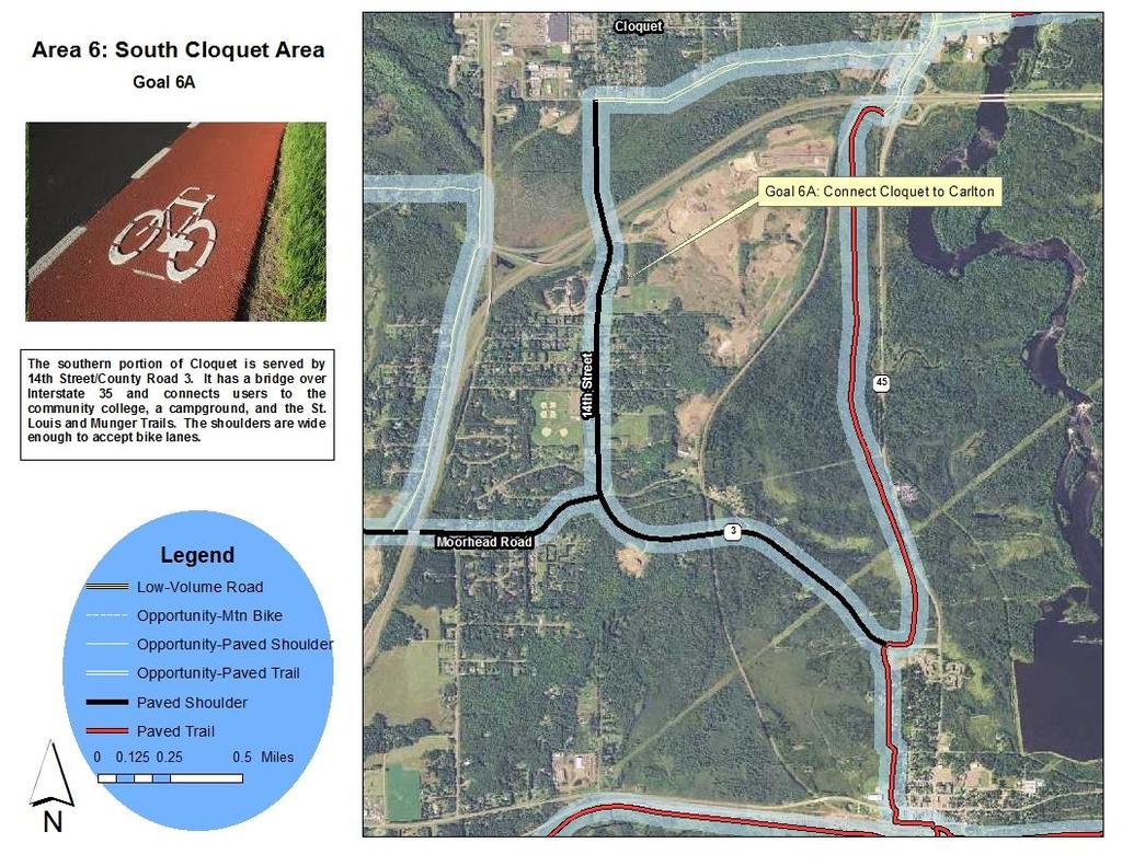
24 Area 6: South Cloquet Area The area south of the Cloquet Community Core is a mix of rural and suburban residential areas. Fond du Lac Community and Tribal College is located in this area south of Interstate 35 as well. County Road 3 (also known as 14 th Street and Carlton Road) bisects the neighborhood. County Road 3 has wide paved shoulders and an upcoming bridge upgrade will raise the shoulder barriers, enhancing the route s bikeability. A. Designate and sign County Highway 3 as a bike route County Highway 3, also known as 14 th Street and Carlton Road, has wide shoulders and provides connections to Cloquet, the St. Louis River Trail, and the Willard Munger State Trail. This plan recommends that the roadway be designated as a bikeway, particularly after the shoulder barriers on the Interstate 35 bridge are raised. Route Statistics: Goal: Connect Cloquet to Fond du Lac Community College, Carlton, St. Louis River Trail, the Willard Munger State Trail, and Black Bear Casino Resort Reasoning: This roadway is a key connector for several bike destinations Existing facilities: Wide shoulders Needed improvements: Signage, striping Distance:.4 miles Construction Cost: $47,760 Design and Engineering Cost: $7,160 Page 21
25 Page 22
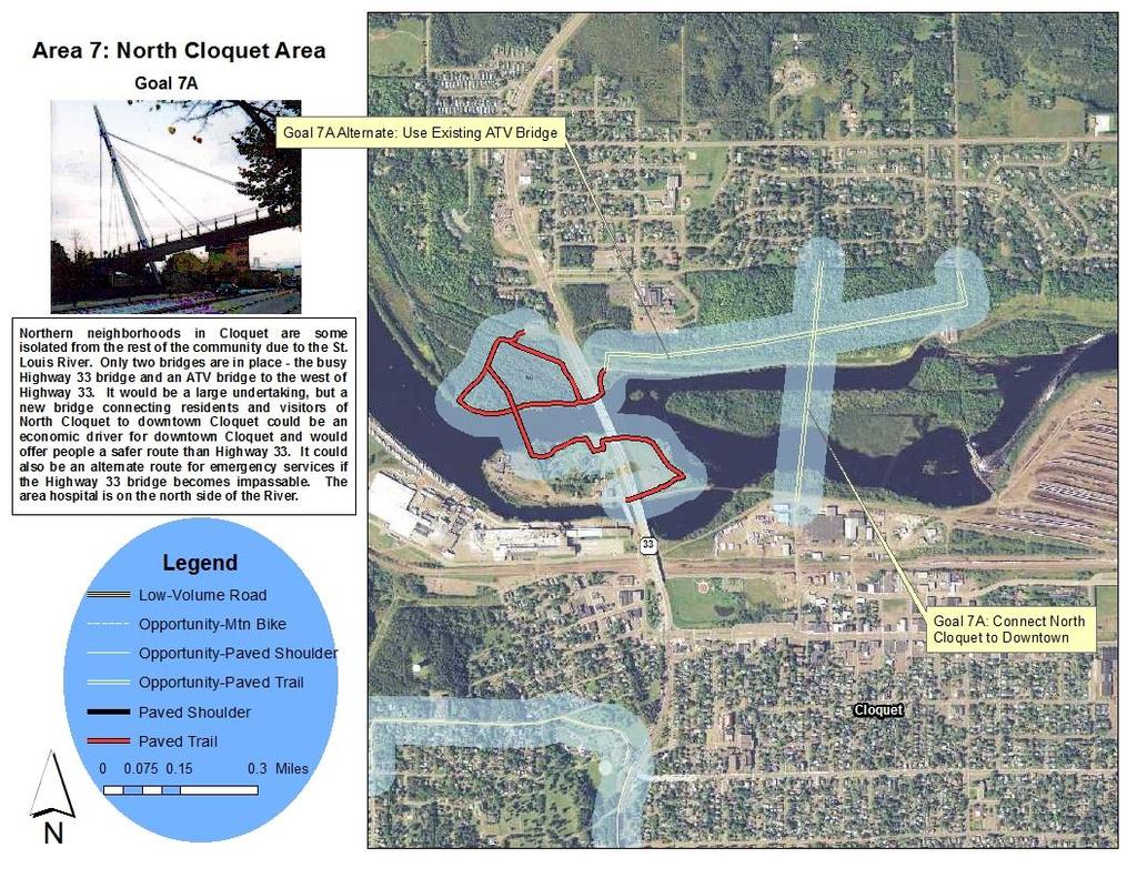
26 Area 7: North Cloquet Area North of the Cloquet Community Core and the St. Louis River is an area that includes residences and businesses (including the area hospital). The only transportation connections between the Community Core and the North Cloquet area is the Highway 33 bridge and an ATV route bridge, creating a somewhat isolated area. The Highway 33 bridge is busy and has a sidewalk, but can be intimidating to cyclists. Additionally, Highway 33 north of the bridge has many automobile oriented business entrances and street intersections, creating a very busy, daunting area for bikes and peds. A. Construct a better connection to North Cloquet over the St. Louis River A better connection for peds and bikes should be developed over the River. There are multiple islands north of downtown Cloquet that could help facilitate such a project. Route Statistics: Goal: Provide a designated bike connection to North Cloquet, including its elementary school and hospital/clinic facility, to downtown Cloquet and City s bike route system OfReasoning: Using the Highway 33 bridge is unsafe for many cyclists. Existing facilities: Islands and parks north of Cloquet s downtown. Needed improvements: A new bridge and trail connections to that bridge Distance: 0.4 miles Construction Cost: $5,000,000 Design and Engineering Cost: $750,000 Page 23
27 Page 24
28 Appendix B: Implementation Checklist Area Goal Needed Improvement Action Responsible Party Timeline Notes A: Connect Scanlon to Esko Construct 2.2 miles of off-road trail Seek Funding for Engineering Thomson Township/Trails Committee Short DNR Local Trails Connection Grant; Coastal Program Grant Complete Engineering Carlton County Short Seek Contstruction Funding Thomson Township Short Next Safe Routes to School program is 100%! Construct Trail Carlton County Medium Maintain Trail Carlton County Long 1 B: Connect Esko to Thomson/Munger Trail Ensure quality paved shoulder Assess shoulder Carlton County Short Determine needed investment Carlton County Short Fix Shoulder/Identify Future Project Carlton County Medium C: Support Future Recreational Development of Slate Mine Area Elimination of Air Quality Zone Work with Industry to Determine Steps Trails Committee Medium Undesignate area Industries/State Medium Plan and Construct Trails Trails Committee Long A: Extend St. Louis River Trail north of Interstate 35 to 45/61 Construct 0.58 miles of off road trail Finalize funding for design ARDC/Trails Committee Short Complete Design ARDC/Consultant Short Seek Trail Funding Scanlon/Trails Committee Medium MnDOT may have partial funding for trail within their ROW 2 B: Examine the opportunity for Tall Pine Lane Extension Construct road with bike facility/rr Xing Share idea with the public Scanlon Short Design roadway/crossing ARDC/Consultant Short C: Connect St. Louis River Trail into downtown Cloquet 1.7 miles of off road paved trail Design trail & bridge ARDC/Consultant Short Design alternate trail (if needed) Scanlon/Trails Committee Medium seek construction funding Scanlon/Cloquet Short TAP funds for apps due 2014 A: Designate bicycle routes in central Cloquet Signage of existing routes Identify sign locations Cloquet/Active Transporation Coalition Short Use existing map 3 Install signs Cloquet Medium B: Add an eastern bike route in Cloquet Signage of 22nd Street Identify sign locations Cloquet/Active Transporation Coalition Short Install signs Cloquet Medium A: Connect Big Lake Road Bike Route to Cloquet Striping and signage of Birch, Carlton, and Park Ave/Streets Identify sign locations Cloquet Short 4 Stripe route and install signs Cloquet Medium B: Connect Pinehurst Park to Doddridge Avenue Construct trail/sidewalk on west shoulder of Hwy 33 Write letter to MnDOT requesting action Trails Committee Short A: Connecti Big Lake Road to additional tribal facilities Construct trail in Tribal complex Identify routes Fond du Lac Short Seeking funding for construction Write applications Fond du Lac w/trail committee support Short TAP funds for apps due 2014 B: Connect Tribal complex to Black Bear facility Sign Cartwright Road as bike route Identify sign locations Fond du Lac Short Install signs Fond du Lac TBD Depends on route connectivity 5 Install shoulders on Moorhead Road Review potential project & costs Carlton County Short seek construction funding Carlton County Medium Designate back service road to Black Bear as a bike route Identify sign locations Fond du Lac Medium Install signs and sharrows Fond du Lac Medium C: Connect Black Bear to County Highway 3 Make Moorhead bridge over I-35 safer Review potential project & costs MnDOT Short seek construction funding MnDOT Medium 6 7 A: Designate County Highway 3/14th St as a bike route A: Construct a better connection between N. Cloquet and downtown Designate route Construct bridge over river Review potential project & costs Review potential project & costs Carlton County Cloquet Short Medium Designate alternate route Install signs and construct stripes Construct paved trail to ATV bridge Carlton County Cloquet Short Medium Page 25

29 For more information about this document, please contact: Andy Hubley, AICP ARDC 221 West first Street Duluth MN Page 26
MEETING MINUTES District 1 Trail Planning Meeting 1
 MEETING MINUTES District 1 Trail Planning Meeting 1 June 1, 2017 2:00 PM 3:30 PM City of Two Harbors 2:00 Introductions Attendees: Lisa Austin, MnDOT Bryan Anderson, MnDOT Jasna Hadzic-Stanek, MnDOT Justin
Non-Motorized Transportation
 Non-Motorized Transportation Non-motorized facilities are important components to the transportation system. They provide an environmentally-friendly, low-cost mode of travel. Some of the facilities can
Blueways: Rivers, lakes, or streams with public access for recreation that includes fishing, nature observation, and opportunities for boating.
 Parks, Open Space and Trails PRINCE WILLIAM COUNTY 2008 COMPREHENSIVE PLAN TRAILS PLAN CONTENTS The components of the trails plan are: Intent Definitions Goals, Policies, and Action Strategies Trails Map
Longmont to Boulder Regional Trail Jay Road Connection DRAFT FINAL REPORT
 Longmont to Boulder Regional Trail Jay Road Connection DRAFT FINAL REPORT December 2018 Project Summary Boulder County, Colorado, in partnership with the City of Boulder, is evaluating options for multi-use
Welcome to the Cross County Trail Public Input Session!
 Welcome to the Cross County Trail Public Input Session! Please sign in on the table below! What are we doing here? Camden County has proposed a bicycle and pedestrian trail spanning across the entire county.
University Region Non-Motorized Plan 2015
 Non-Motorized Transportation Non-motorized facilities are important components to the transportation system. They provide an environmentally-friendly, low-cost mode of travel. Some of the facilities can
Trails. Lois Jensen Nature Preserve is a 30 acre parcel on the north end of the city. It provides unspoiled wooded paths.
 Trails Lois Jensen Nature Preserve is a 30 acre parcel on the north end of the city. It provides unspoiled wooded paths. TRAIL S, PATHS, ROUTES AND CONNECTORS Citizen input pointed to trails, paths, bike
CHAPTER FOUR: TRANSPORTATION
 CHAPTER FOUR: TRANSPORTATION Barron County Comprehensive Plan: Transportation Page 61 Background Transportation facilities have a significant influence on land use, development and quality of life for
CHAPTER 4 -- THE LAND USE PLAN: DESCRIPTIONS AND POLICIES FOR THIRTEEN PLANNING AREAS
 CHAPTER 4 -- THE LAND USE PLAN: DESCRIPTIONS AND POLICIES FOR THIRTEEN PLANNING AREAS NORTH CENTRAL CAC AREA LITTLE VALLEY ROAD TO JUG HANDLE CREEK PLANNING AREA This planning area includes Cleone, Noyo,
4. Safety Concerns Potential Short and Medium-Term Improvements
 NH Route 104 Access Management Study Page 19 4. Safety Concerns Potential Short and Medium-Term Improvements Potential safety improvement strategies are listed by priority based on field observations by
chapter - Hex Highway Touring Route Hamburg to Strausstown Overview
 chapter - 2 Hex Highway Touring Route Hamburg to Strausstown Overview The on-road Hex Highway automobile and bicycle touring route begins on State Street in downtown Hamburg. The route continues west on
Segment 2: La Crescent to Miller s Corner
 goal of the USFWS refuges is to conserve, protect and enhance fish, wildlife and plants and their habitats for the continuing benefit of the American people. Refuge lands are used largely for fishing,
3. COLTA / HUGA CONNECTIONS - PRELIMINARY
 9 3. COLTA / HUGA CONNECTIONS - PRELIMINARY 3.1 COLTA The Chain of Lakes Trail Association (COLTA) trail, formerly identified as the Chester Spur Line, was completed and opened for use in June 2011. The
Two Harbors Trail System Plan
 Two Harbors Trail System Plan May 2005 Two Harbors Planning and Zoning Commission Two Harbors Trails Plan May 2005 Adopted by: The City of Two Harbors Robin Glaser, Mayor 2005 City Council John Jacoby,
AGENDA ITEM 5 D WAKULLA ENVIRONMENTAL INSTITUTE (WEI) TRAIL FEASIBILITY STUDY
 TRAIL FEASIBILITY STUDY") March 19, 2018 AGENDA ITEM 5 D WAKULLA ENVIRONMENTAL INSTITUTE (WEI) TRAIL FEASIBILITY STUDY TYPE OF ITEM: Action STATEMENT OF ISSUE The Wakulla Environmental Institute (WEI) Trail is one of several trails
March 19, 2018 AGENDA ITEM 5 D WAKULLA ENVIRONMENTAL INSTITUTE (WEI) TRAIL FEASIBILITY STUDY TYPE OF ITEM: Action STATEMENT OF ISSUE The Wakulla Environmental Institute (WEI) Trail is one of several trails
Abbott Rd Rehabilitation Phase II - Elmore Rd to Birch Rd
 Abbott Rd Rehabilitation Phase II - Elmore Rd to Birch Rd Project ID SOA07003 Department State of Alaska Project Type Improvement Start Date December 2017 Location Assembly: Section 4, Seats F & G, Assembly:
Georgetown-Lewes Rail/Trail Study. Rail/Trail Study: Cool Spring to Cape Henlopen State Park New Road Extension (House Resolution No.
 Georgetown-Lewes Rail/Trail Study Rail/Trail Study: Cool Spring to Cape Henlopen State Park New Road Extension (House Resolution No. 47) August 22, 2011 Presentation Outline Background Benefits Statewide
Citrus Heights Creek Corridor Trail Project Trail Advisory Group Field Trip #2 September 11, :00 11:00 am Trellis Hall, Citrus Heights
 September 11, 2013 9:00 11:00 am Trellis Hall, Citrus Heights Project Overview The City of Citrus Heights is studying the feasibility of establishing a multi use trail system within the City s 26 miles
Becker County Trail Routing Feasibility Study
 2016 Becker County Trail Routing Feasibility Study CONNECTING DETROIT MOUNTAIN AND MOUNTAIN VIEW RECREATIONAL AREA TO THE HEARTLAND TRAIL BECKER COUNTY ULTEIG ENGINEERS Contents Acknowledgements...2 INTRODUCTION...3
FEASIBILITY CRITERIA
 This chapter describes the methodology and criteria used to evaluate the feasibility of developing trails throughout the study areas. Land availability, habitat sensitivity, roadway crossings and on-street
CITY OF ORR TRANSPORTATION IMPROVEMENT PLAN JUNE Prepared by: Arrowhead Regional Development Commission Regional Planning Division
 CITY OF ORR TRANSPORTATION IMPROVEMENT PLAN JUNE 2012 Prepared by: Arrowhead Regional Development Commission Regional Planning Division City of Orr Transportation Improvement Plan 2012 Prepared for the
Chapter 6: POLICY AND PROCEDURE RECOMMENDATIONS
 Chapter 6 POLICY AND PROCEDURE RECOMMENDATIONS FOR SRRA Below are seven policy elements that should be considered for adoption by the Southwest Regional Recreation Authority of Virginia: 1. Develop strategies
2. Goals and Policies. The following are the adopted Parks and Trails Goals for Stillwater Township:
 D. PARKS AND TRAILS 1. Introduction Stillwater Township s population is relatively low, with most residents living on rural residences on large lots. The need for active park space has been minimal in
2016 Regional Transportation Alternatives Program (TAP) Grant Application
 Grant Application") 2016 Regional Transportation Alternatives Program (TAP) Grant Application PROJECT TITLE: Yelm-Tenino Trail Extension Feasibility Study TRPC use only GENERAL PROJECT INFORMATION Agency or Organization City
2016 Regional Transportation Alternatives Program (TAP) Grant Application PROJECT TITLE: Yelm-Tenino Trail Extension Feasibility Study TRPC use only GENERAL PROJECT INFORMATION Agency or Organization City
EXECUTIVE SUMMARY FALL Introduction. Findings
 EXECUTIVE SUMMARY FALL 2004 Introduction Trails are one of the most popular and highly desirable recreational resources in communities of all sizes throughout the country. In addition to providing a safe
OR MISSION TRAIL ELEMENTARY
 Leawood: overview OVERLAD PARK 24: p.70 I-LA PARK 32: p.72 TOMAHAWK PARK 23: p.69 31: p.71 GEZER PARK OR MISSIO TRAIL ELEMETARY 22: p.68 W 133rd St W 135th St KASAS CITY MO - other segments Beginning/end
Draft CITY OF TWO HARBORS TRAILS PLAN
 CITY OF TWO HARBORS TRAILS PLAN Adopted 2005 Updated 2018 ACKNOWLEDGEMENTS This plan was developed by the City of Two Harbors Trees & Trails Commission, facilitated by the City of Two Harbors Planning
Mohawk Hudson Bike Hike Trail Crossroad Connection Study
 Summary Report - April 21, 2003 Mohawk Hudson Bike Hike Trail Crossroad Connection Study Summary Report Introduction The Capital District Transportation Committee (CDTC), in partnership with Albany County,
Minnesota Great River Road Transportation Alternatives Local Project Summaries December 19, 2016
 Minnesota Great River Road Transportation Alternatives Local Project Summaries December 19, 2016 For MN-MRPC Consideration on January 5, 2017 and Potential Letters of Support Aitkin pg. 2 Brainerd pg.
DRAFT - APRIL 13, 2007 ROUTING STUDY FOR TRAIL CONNECTIONS BETWEEN CALAIS AND AYERS JUNCTION
 DRAFT - APRIL 13, 2007 ROUTING STUDY FOR TRAIL CONNECTIONS BETWEEN CALAIS AND AYERS JUNCTION Abstract The vision for the East Coast Greenway is an off-road urban trail system running from Calais, Maine
A CASE FOR COMPLETING THE JORDAN RIVER PARKWAY: A
 A CASE FOR COMPLETING THE JORDAN RIVER PARKWAY: A safe crossing at 9000 South and 850 West Proposed 9000 South Underpass Parkway Timeline Parkway, Trail, and Tourism Facts Blueprint Jordan River 1971 1973
TRUCKEE TAHOE AIRPORT DISTRICT BOARD OF DIRECTOR STAFF REPORT
 AGENDA ITEM: 11 TRUCKEE TAHOE AIRPORT DISTRICT BOARD OF DIRECTOR STAFF REPORT AGENDA TITLE: MEETING DATE: January 24, 2018 PREPARED BY: NTPUD Agency Partnership Opportunity, Multi-Use Trailhead Access
4.19 Parks, Recreation, and Conservation Lands
 interchange would have on the Reed Paige Clark Homestead located on the north side of Stonehenge Road. Alternative D would also affect Palmer Homestead, E.F. Adams House, and Knapp Brothers Shoe Manufacturing
Auburn Trail / Ontario Pathways Trail Connector Feasibility Study Public Information Meeting Wednesday, August 22, 2012
 Auburn Trail / Ontario Pathways Trail Connector Feasibility Study Public Information Meeting Wednesday, August 22, 2012 Purpose of Feasibility Study Purpose Evaluate the feasibility of constructing a multiuse
Route 29 Solutions Projects
 Your guide to the Route 29 Solutions Projects For full details & continued engagement please visit www.route29solutions.org The Route 29 Solutions Package is a $230 million investment into the improvement
TRAFALGAR PARK. 78: p.140 W 99th St FLAT ROCK CREEK PARK. W 103rd St OVERLAND PARK. Quivira Rd. College Blvd. Shared use path. Mountain bike trail
 Lenexa: overview TRAFALGAR PARK 78: p.140 As the Westport Route crosses over Lenexa's boundaries with Olathe and Overland Park several times, approximately 2.75 or 3 miles of the historic route of the
Macleod Trail Corridor Study. Welcome. Macleod Trail Corridor Study Open House. Presentation of Proposed Design Concepts
 Macleod Trail Corridor Study Welcome Macleod Trail Corridor Study Open House Presentation of Proposed Design Concepts Study Purpose Develop a corridor plan for Macleod Trail that aligns with The City s:
Section II. Planning & Public Process Planning for the Baker/Carver Regional Trail began in 2010 as a City of Minnetrista initiative.
 Section II Planning & Public Process Planning for the began in 2010 as a City of initiative. city staff began discussions with the Park District on the possibility of a north/south regional trail connection
Glacial Lakes State Trail Master Plan Amendment Trail Extension into Downtown Willmar
 Glacial Lakes State Trail Master Plan Amendment Trail Extension into Downtown Willmar Minnesota Department of Natural Resources Division of Parks and Trails July 2012 Glacial Lakes State Trail Master Plan
Community Development Committee
 C Community Development Committee For the Metropolitan Council meeting of October 31, 2012 Committee Report Item:2012-316 ADVISORY INFORMATION October 16, 2012 Date Prepared: Subject: Intercity Regional
4.0 Context for the Crossing Project
 4.0 Context for the Crossing Project This section provides background information about key features of the North Douglas Crossing project area, and opportunities and constraints. This information is important
Committee. Presentation Outline
 CW-33-15 11/9/2015 Community and Corporate Services Committee November 10, 2015 1 Presentation Outline Background Vision and Objectives Study Process and Timeline Public and Stakeholder Engagement Organization
Business Item No XXX. Proposed Action That the Metropolitan Council approve the Coon Creek Regional Trail Master Plan.
 Business Item No. 2015-XXX Metropolitan Parks and Open Space Commission Meeting date: July 7, 2015 For the Community Development Committee meeting of July 20, 2015 For the Metropolitan Council meeting
FERN RIDGE TRAIL SYSTEM. Vision & Strategies
 FERN RIDGE TRAIL SYSTEM Vision & Strategies July, 2007 Table of Contents Introduction: The Vision...1 The Need for a Trail System: Growth and Population Trends...3 The Mapping Process...7 Project Descriptions..
City of Durango 5.8 FUNDING TRAILS DEVELOPMENT
 5.8 FUNDING TRAILS DEVELOPMENT The City has been successful in establishing dedicated local funding sources as well as applying for grants to develop the City s trail system, having received nearly $2.4
This section provides the basic information about the park or trail and the organizations responsible for it. Funding Application F
 General This section provides the basic information about the park or trail and the organizations responsible for it. Park/Trail ID # 16-43D Last Update July 13, 217 District 2 Funding Application 17-82-F
Business Item No
 Metropolitan Parks and Open Space Commission Meeting date: February 6, 2018 For the Community Development Committee meeting of February 20, 2018 For the Metropolitan Council meeting of February 28, 2018
Committee Report. Community Development Committee For the Metropolitan Council meeting of August 12, Business Item No.
 Committee Report Business Item No. 2015-168 Community Development Committee For the Metropolitan Council meeting of August 12, 2015 Subject: Coon Creek Regional Trail Master Plan, Anoka County Proposed
Welcome to the Illinois High-Speed Rail Chicago to St. Louis Construction Update Meeting. Today s meeting will provide an overview of the Program,
 Welcome to the Illinois High-Speed Rail Chicago to St. Louis Construction Update Meeting. Today s meeting will provide an overview of the Program, updates on construction to be held in this area, and how
Little River Trail Feasibility Study
 Final April, 2014 Prepared for the State Coastal Conservancy By the Natural Resources Services Division of Redwood Community Action Agency Table of Contents Executive Summary... 1 1. Project Purpose and
City of Mahtomedi Park System Plan Public Hearing Draft: September 13, 2006
 Chapter 4: TRAIL SYSTEM PLAN INTRODUCTION Mahtomedi developed in the late 1800s and early 1900s as a summer resort and vacation community. As such, the transportation system included narrow, winding roads
At the time, the portion of the line through Eagle County remains wholly under the ownership of Union Pacific Railroad (UP).
.") Chapter 5 The Railroad Corridor as a Trail Corridor The intent of this chapter is to identify how the rail corridor, if available for lease or purchase in all or part, could be incorporated into the core
Chapter 5 The Railroad Corridor as a Trail Corridor The intent of this chapter is to identify how the rail corridor, if available for lease or purchase in all or part, could be incorporated into the core
Gardner: overview. Santa Fe, Oregon, and California National Historic Trails UNINCORPORATED JOHNSON COUNTY OLATHE UNINCORPORATED JOHNSON COUNTY
 Santa Fe, Oregon, and California ational Historic Trails : overview 99: p.134 100: p.135 GARDER JUCTIO 102: p.137 56: p.126 EDGERTO Burlington orthern Intermodal and Logistics 98: p.133 101: p.136 S Waverly
Emily to Blind Lake Trail PROPOSED TRAIL DEVELOPMENT APPLICATION SUMMARY
 Emily to Blind Lake Trail PROPOSED TRAIL DEVELOPMENT APPLICATION SUMMARY Township 137 Range 26 (Fairfield Township) sections 2 & 3 Township 138 Range 26 (City of Emily) sections 27, 34, 35, & 36 Township
Regional Wayfinding Sign Strategy Thurston County Trails 2017
 Regional Wayfinding Sign Strategy Thurston County Trails 2017 Partners: Members and partnering organizations of the Thurston Thrives Community Design Action Team City of Lacey, City of Olympia, City of
1.2 Corridor History and Current Characteristics
 SECTION 1 Description and Background of Study Area 1.1 Introduction This preliminary engineering report was prepared for the Alaska Department of Transportation and Public Facilities (ADOT&PF). It is part
State Route 8 Corridor. Northern Summit County s Path to Success
 State Route 8 Corridor Northern Summit County s Path to Success Construction Guide: 2008-2009 State Route 8 corridor work description State Route 8 Corridor 10 projects $262 million With its close proximity
Schoolcraft Township is located in northeast Houghton County. A portion of the township borders Keweenaw County and Lake Superior.
 COMMUNITY DESCRIPTION Schoolcraft Township is located in northeast Houghton County. A portion of the township borders Keweenaw County and Lake Superior. The township is largely rural but has one main population
ANCLOTE COASTAL TRAIL ALTERNATIVES ANALYSIS STUDY
 ANCLOTE COASTAL TRAIL ALTERNATIVES ANALYSIS STUDY PASCO COUNTY MPO JULY 2015 PROJECT OVERVIEW... INTRODUCTION EXECUTIVE SUMMARY CONTEXT... TAMPA BAY AREA, PINELLAS, & PASCO COUNTY S MULTI-USE TRAIL PLANS
Grade Crossings in High Speed Rail Corridors
 Grade Crossings in High Speed Rail Corridors 59 th ANNUAL ILLINOIS TRAFFIC ENGINEERING & SAFETY CONFERENCE October 21, 2010 Champaign, IL Michael E. Stead Rail Safety Section Illinois Commerce Commission
Coast to Coast Connector Summit
 Project Partners Welcome to the Coast to Coast Connector Summit Winter Garden, Florida City Hall October 1, 2014 1 Why are we here? Objectives 1. Inform key stakeholders on the current state of the C2C
Environment and Natural Resources Trust Fund 2019 Request for Proposals (RFP)
") Environment and Natural Resources Trust Fund 2019 Request for Proposals (RFP) Project Title: Glacial Edge Trail and Downtown Pedestrian Bridge Category: G. Land Acquisition for Habitat and Recreation ENRTF
Environment and Natural Resources Trust Fund 2019 Request for Proposals (RFP) Project Title: Glacial Edge Trail and Downtown Pedestrian Bridge Category: G. Land Acquisition for Habitat and Recreation ENRTF
Stage 2 ION: Light Rail Transit (LRT) from Kitchener to Cambridge
 from Kitchener to Cambridge") Stage 2 ION: Light Rail Transit (LRT) from Kitchener to Cambridge Public Consultation Centre (PCC) No. 3 Please Sign-in Cambridge City Hall November 21, 2017 2:00 to 8:00pm Preston Memorial Auditorium
Stage 2 ION: Light Rail Transit (LRT) from Kitchener to Cambridge Public Consultation Centre (PCC) No. 3 Please Sign-in Cambridge City Hall November 21, 2017 2:00 to 8:00pm Preston Memorial Auditorium
Lake Erie Commerce Center Traffic Analysis
 LOCATION: East of NYS Route 5 at Bayview Road Town of Hamburg Erie County, New York PREPARED BY: Wendel Companies 140 John James Audubon Parkway Suite 200 Amherst, New York 14228 January 2012 i ii Table
COMMUNITY LOS PRIORITIES
 Part 5. Community Priority Meetings Purpose: The purpose of holding Community Priority Meetings was two-part; (1) to gather input from community members and decision makers on specific park and trail infrastructure
3. Trail Alignment. Overview. Criteria for Location of the Trail
 3. Trail Alignment Overview The Houston to La Crescent Extension of the Root River Trail is part of the legislatively authorized Blufflands State Trail System. The entire trail segment is approximately
Cascade River State Park Management Plan Amendment
 This document is made available electronically by the Minnesota Legislative Reference Library as part of an ongoing digital archiving project. http://www.leg.state.mn.us/lrl/lrl.asp Cascade River State
Chapter 6. Action Program. Heart of the Lakes Area Recreation Plan
 Heart of the Lakes Area Recreation Plan 1. Design and construct the following trails (please see the following map): a. the Speedway Trail 1) primary pathway the main trail 2) secondary pathway the proposed
Airport Planning Area
 PLANNING AREA POLICIES l AIRPORT Airport Planning Area LOCATION AND CONTEXT The Airport Planning Area ( Airport area ) is a key part of Boise s economy and transportation network; it features a multi-purpose
Hudson Highlands Fjord Trail Draft Master Plan. April 29, 2015
 Hudson Highlands Fjord Trail Draft Master Plan April 29, 2015 Agenda Route Overview Proposed Segment Results of Community Survey on that Segment Next Steps Municipal Endorsement Environmental Review Implementation
Waukee Trailhead Public Art and Amenities Project
 Waukee - Trailhead Public Art and Amenities Project Sponsor Waukee Project Title Waukee Trailhead Public Art and Amenities Project Termini Description ( i.e. Park Avenue to 19th Street) NE Intersection
Additional Economic Development Strategy submissions- Klickitat County
 Klickitat County Transportation Improvement Projects 1 White Salmon to Hood River Bridge Final EIS, design, bridge replacement 2 Klickitat County Rural Arterials Reconstruct to all-weather roads Part of
Northaven Trail Phase 2 Initial Project Overview
 Northaven Trail Phase 2 Initial Project Overview Partnership Project to extend existing Northaven Trail Improve Bike/Ped Connectivity On Dallas Trail Network Plan City and County Funding Oncor Texas Trails
Northeast Quadrant Distinctive Features
 NORTHEAST QUADRANT Northeast Quadrant Distinctive Features LAND USE The Northeast Quadrant includes all the area within the planning area that is east of Interstate 5 and to the north of State Route 44.
County of Peterborough Active Transportation Master Plan
 The TMP developed a conceptual AT/cycling network for Peterborough County that identified both on-road and off-road (trail) AT facilities. This was a coarse network based on the existing trails and off-road
The Recreational Trail along Cushing Park road has been a successful addition to the city
 The Recreational Trail along Cushing Park road has been a successful addition to the city Trails TRAILS, PATHS, ROUTES AND CONNECTORS Citizen input pointed to trails, paths, bike routes, and other non-motorized
Committee Report. Community Development Committee For the Metropolitan Council meeting of April 13, Business Item No.
 Committee Report Business Item No. 2016-48 Community Development Committee For the Metropolitan Council meeting of April 13, 2016 Subject: Harriet Island-South St. Paul Regional Trail Master Plan, Saint
Trail # NW Tuesday, June DESIGN. Provide an Review the Provide an. Project Goals: System system. wayfinding
 I. Welcome / Introductions Bethany Creek Trail #2 Segment 3 Neighborhood Meeting #1 Bethany Presbyterian Church 15505 NW Springville Road, Portland, OR 97229 Tuesday, June 26, 2018 @ 6:00PM Meeting Minutes
Community Development
 Community Development City & Borough of Juneau Community Development 155 S. Seward Street Juneau, AK 99801 (907) 586 0715 Phone (907) 586 4529 Fax DATE: February 11, 2016 TO: FROM: Planning Commission
Tallahassee-St. Marks Historic Railroad Trail
 Revitalizing a Historic Trail Designated as a National Recreation Trail, the 16-mile Tallahassee-St. Marks Historic Railroad Trail has been enjoyed by countless bicyclists, runners, and outdoor enthusiasts
Other Principle Arterials Minor Arterial Major Collector Minor Collector Local
 CHAPTER 10 TRANSPORTATION Introduction The system of public roads in East Pikeland Township is decidedly rural in character. Since the 1984, the road network has remained much the same, with the addition
Transportation TRANSPORTATION PROJECTS
 Transportation TRANSPORTATION PROJECTS Balls Ford Road Interchange Total Project Cost $142.9M This project includes the construction of a new diverging diamond interchange at Route 234 Bypass (Prince William
user s guide to Transportation Improvements in Astoria Planning Efforts outside Astoria for more information, contact:
 The Miles Crossing/ Jeffers Garden transportation plan (underway), will identify needed improvements to the Warrenton Astoria Highway and local street improvements to serve expected growth in the Miles
Lafourche Parish Government REQUEST FOR QUALIFICATIONS. Landscape Architectural Services
 Lafourche Parish Government REQUEST FOR QUALIFICATIONS Landscape Architectural Services Bayou Lafourche Parish Multi-Use Path Feasibility Study Phase 1 And Bayou Lafourche Parish Multi-Use Path Feasibility
FINCH HYDRO CORRIDOR TRAIL PROJECT
 FINCH HYDRO CORRIDOR TRAIL PROJECT Pharmacy Avenue to Birchmount Road January 29 th, 2018 L Amoreaux Community Centre (2000 McNicoll Avenue) 1 Purpose of Drop In Event The purpose of today s drop-in event
The Baker/Carver Regional Trail is intended to
 Section V Design Guidance The Baker/Carver Regional Trail is intended to safely accommodate 183,000 annual visits, an array of non-motorized uses, a variety of skill levels, and persons with special needs.
Saginaw Charter Township Master Plan
 Saginaw Charter Township Master Plan Overview of Draft & Public Hearing August 20, 2014 230 South Washington Avenue Saginaw Michigan 48607 (989) 754-4717 www.spicergroup.com Saginaw Charter Township Master
Town of Limon Comprehensive Plan CHAPTER 6 TOURISM AND THE VISITOR ECONOMY
 CHAPTER 6 TOURISM AND THE VISITOR ECONOMY 65 VISION Limon s location at the intersection of Interstate 70, and Highways 24, 40, 71, and 287, provides steady traveler traffic with an estimated 80,000 overnight
Memo. Orange City Trail Plan Becky Mendez, AICP Jamie Krzeminski, PE, PTOE Matt Wiesenfeld, PE, AICP. Development of the Existing and Proposed Network
 Memo Date: Friday, December 22, 2017 Project: To: From: Subject: Trail Plan Becky Mendez, AICP Jamie Krzeminski, PE, PTOE Matt Wiesenfeld, PE, AICP Development of the Existing and Proposed Network HDR
Greater Minnesota Regional Parks and Trails Commission Designation Application
 Greater Minnesota Regional Parks and Trails Commission Designation Application General Section Designation Application #: 15-050D Date Submitted: 06/30/2015 Park or Trail Name: Perham to Pelican Rapids
Town of Frisco. Trails Master Plan. Legend. Planning Area 1. i l. 9 Campground. Lake Hill Development. Giberson Property. Frisco Transit Center
 SO-UV I-70 UPPER SALT LICK TOO-PWECH SUNRISE 1 Town of Frisco Planning Area 1 NAH-OON-KARA I-70 Lake Hill Development Legend Existing Trails Existing USFS System Trails 2 A Existing Non-System Trails Bike
ALBANY-HUDSON ELECTRIC TRAIL FEASIBILITY STUDY. Final Report OCTOBER 2011
 ALBANY-HUDSON ELECTRIC TRAIL FEASIBILITY STUDY Final Report OCTOBER 2011 ALBANY-HUDSON ELECTRIC TRAIL FEASIBILITY STUDY Prepared for: Town of East Greenbush 225 Columbia Turnpike Rensselaer, New York 12144
Gold Coast. Rapid Transit. Chapter twelve Social impact. Chapter content
 Gold Coast Rapid Transit Chapter twelve Social impact Chapter content Social impact assessment process...235 Existing community profile...237 Consultation...238 Social impacts and mitigation strategies...239
SAN FRANCISCO MUNICIPAL TRANSPORTATION AGENCY
 THIS PRINT COVERS CALENDAR ITEM NO. : 10.4 DIVISION: Sustainable Streets BRIEF DESCRIPTION: SAN FRANCISCO MUNICIPAL TRANSPORTATION AGENCY Approving various parking and traffic modifications associated
United States Department of the Interior National Park Service. Boundary Expansion Listed in National Register January 11, 2017
 NPS Form 10900-a (Rev. 8/2002) OMB No. 10240018 United States Department of the Interior National Park Service Boundary Expansion Listed in National Register January 11, 2017 National Register of Historic
Greater Minnesota Regional Parks and Trails Commission Designation Application
 Greater Minnesota Regional Parks and Trails Commission Designation Application General Section Designation Application #: 15-059D Date Submitted: 06/16/2015 Park or Trail Name: Mesabi Trail District #:
Site Location and Setting
 Memorandum Date: To: From: Subject: Kristy Le, Gary Black Steve Orem Santa Teresa County Park Historic Area Traffic and Parking Study Hexagon Transportation Consultants, Inc. has completed a traffic and
The Vision for the San Juan Islands Scenic Byway
 The Vision for the San Juan Islands Scenic Byway 2 Judd Cove, Orcas Island, Courtesy of Kurt Thorson (kurtthorson.com) and San Juan County Land Bank Vision for the San Juan Islands Scenic Byway The San
Current Amendment or Modification. Prior Amendment or Modification. All other Amendments and Modifications
 Individual HIGHWAYS Bridge - On State System SR46598 P-4 Region 4 Bridge - On System Pool CDOT Region 4 Bridge Federal National Highway Performance Program - - 956 483 719 719 2,877 State State Highway
LUDLAM TRAIL CORRIDOR DISTRICT
 1 APPLICATION NO. 9 MAY 2015 CDMP CYCLE LUDLAM TRAIL CORRIDOR DISTRICT PLANNING ADVISORY BOARD November 2, 2015 BACKGROUND 2 Staff Application Former Florida East Coast railroad corridor (privately owned)