Bike/Pedestrian/Golf Cart Trail Recommendations for the City of Dasher
|
|
|
- Kristin Young
- 5 years ago
- Views:
Transcription
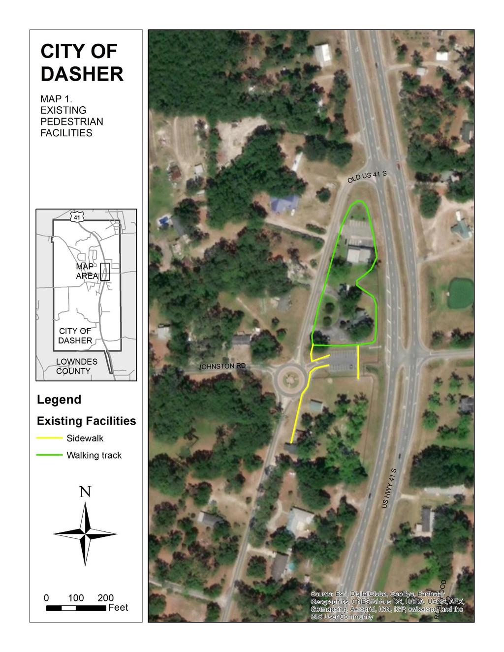
1 Valdosta-Lowndes MPO Memo To: From: City of Dasher Mayor and City Council VLMPO Staff CC: Date: 7/12/2018 Re: Bike/Pedestrian/Golf Cart Trail Recommendations for the City of Dasher The City of Dasher is proposing to construct off-road trails for use by bicyclists, pedestrians, and golf carts. The City has requested recommendations from VLMPO staff regarding potential trail corridors, design guidelines, and best practices. This memorandum contains recommendations based on research and field visits conducted by VLMPO staff between February and June of The City of Dasher already has some excellent public facilities, including a walking trail at the City s central park (see Map 1). Development of additional trails could further enhance the quality of life in the City. A total of 4.5 miles of potential corridors for trail development have been identified, as follows (see Map 2): Carroll Ulmer Road, between existing road and railroad tracks Johnston Road Dasher Road Triple Lake Drive/Triple Lake Road, connecting through to Glen Meade Drive Old US 41 South. An Equal Opportunity Employer / Program 327 W. Savannah Ave., Valdosta, GA Phone (229) Fax (229) S. Ga. Parkway, W., Waycross, GA Phone (912) Fax (912)
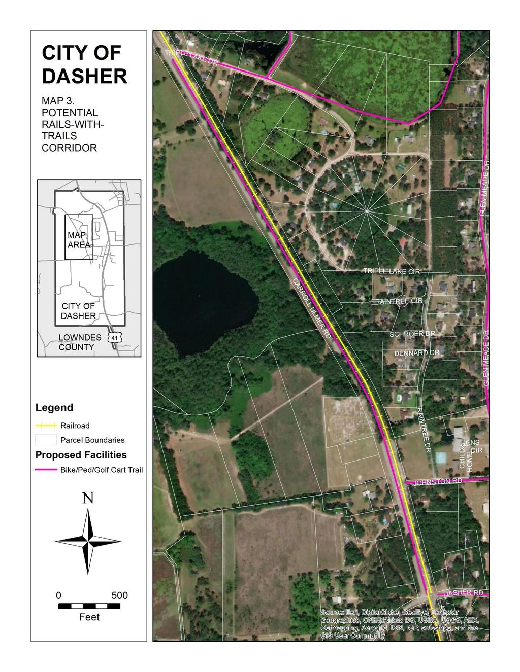
2 1. General Recommendations a. To accommodate golf carts in addition to bicyclists and pedestrians, all trails should be at least 10 feet in width, in keeping with AASHTO design standards and with practices used by other communities allowing golf carts on trails, for example Peachtree City. b. Best practices specific to pedestrian and bicycle infrastructure for rural communities in this region are in the SGRC report, Best Practices for Complete Streets in Rural Communities. Most of the City of Dasher is suburban or rural in character (see Best Practices Guide pp for specific recommendations). c. A rails-with-trails project could potentially be part of this trail system (along Carroll Ulmer Road). A summary of the potential for rails-with-trails projects in this region is contained in the SGRC report, Potential Rails-With-Trails Corridors In Southern Georgia. d. Signs should be posted indicating the trails intended users (see Figure 1). Consider posting signs with speed limits and/or general rules for trail users. 2. Specific Recommendations a. The new trail system should connect directly to Dasher Park, with appropriately marked street crossings (see Figure 2). Golf cart parking at Dasher Park may become an issue and should be clearly demarcated (see Figure 3). b. For an east-west connection, trails would be feasible alongside both Johnston Road and Dasher Road, but Dasher Road has more right-of-way width available. The right-of-way on Dasher Road is 60 feet wide, whereas it is 40 feet wide on Johnston Road. A trail along Dasher Road would also have the advantage of connecting directly to Georgia Christian School. c. Along the Carroll Ulmer Road right-of-way, sufficient space is available between the road and the railway to construct a rails-with-trails project. The right of way is approximately 150 feet wide from Dasher Road north to the point where Carroll Ulmer Road diverges from the railroad (see Map 3). Considerable clearing and grading would be needed in some locations. The City should coordinate with the railroad company (Norfolk Southern) and determine the exact location of the railroad easement. The costs of constructing shared-use paths vary substantially depending on materials used, right-of-way costs, and other factors. A paved multiuse trail can cost anywhere from approximately $65,000 per mile to more than $4 million per mile. Annual maintenance costs per mile may range from approximately $2,000 to $12, Sources: Pedestrian and Bicycle Information Center (( and Rails to Trails Conservancy ( 2
3 (Sources: d. At the corner of Triple Lake Drive and Triple Lake Road there is a City park with a lake. A connection to this park would be a good amenity for the community. From there, the trail could continue either along Triple Lake Drive and/or to the south of the large lake, and continue east to US-41. Some of the land in this area is owned by the City, but some is owned by private individuals. A further trail along US-41 could then proceed along Glen Meade Drive and connect through to Johnson Road (see Map 2). Note that golf carts cannot be operated on US-41, and any activities within the right of way of a state or federal highway must be overseen by the appropriate state or federal agency. e. The community has indicated that a connection from Raintree Drive through to Triple Lake Circle is not desired. Attachments: Figures 1 through 3 Map 1 Existing Pedestrian Facilities Map 2 Potential Corridors for Trail Development Map 3 Potential Rails-with-trails Corridor 3


 Figure")
4 Figure 1. Shared trail sign examples. Figure 2. Example of a roundabout with marked crosswalks and connection to a multi-use trail. (Dublin, Ohio; Source: Google Street View) Figure 3. Example of a golf cart parking sign. 4
5 5
6 6
7 7
FEASIBILITY CRITERIA
 This chapter describes the methodology and criteria used to evaluate the feasibility of developing trails throughout the study areas. Land availability, habitat sensitivity, roadway crossings and on-street
Blueways: Rivers, lakes, or streams with public access for recreation that includes fishing, nature observation, and opportunities for boating.
 Parks, Open Space and Trails PRINCE WILLIAM COUNTY 2008 COMPREHENSIVE PLAN TRAILS PLAN CONTENTS The components of the trails plan are: Intent Definitions Goals, Policies, and Action Strategies Trails Map
ANCLOTE COASTAL TRAIL ALTERNATIVES ANALYSIS STUDY
 ANCLOTE COASTAL TRAIL ALTERNATIVES ANALYSIS STUDY PASCO COUNTY MPO JULY 2015 PROJECT OVERVIEW... INTRODUCTION EXECUTIVE SUMMARY CONTEXT... TAMPA BAY AREA, PINELLAS, & PASCO COUNTY S MULTI-USE TRAIL PLANS
Gardner: overview. Santa Fe, Oregon, and California National Historic Trails UNINCORPORATED JOHNSON COUNTY OLATHE UNINCORPORATED JOHNSON COUNTY
 Santa Fe, Oregon, and California ational Historic Trails : overview 99: p.134 100: p.135 GARDER JUCTIO 102: p.137 56: p.126 EDGERTO Burlington orthern Intermodal and Logistics 98: p.133 101: p.136 S Waverly
Non-Motorized Transportation
 Non-Motorized Transportation Non-motorized facilities are important components to the transportation system. They provide an environmentally-friendly, low-cost mode of travel. Some of the facilities can
City of Durango 5.8 FUNDING TRAILS DEVELOPMENT
 5.8 FUNDING TRAILS DEVELOPMENT The City has been successful in establishing dedicated local funding sources as well as applying for grants to develop the City s trail system, having received nearly $2.4
Rails with Trails Finding the mobility, safety, and liability sweet spot 5/10/2017
 Rails with Trails Finding the mobility, safety, and liability sweet spot 5/10/2017 The National Transportation Systems Center Advancing transportation innovation for the public good U.S. Department of
Memo. Orange City Trail Plan Becky Mendez, AICP Jamie Krzeminski, PE, PTOE Matt Wiesenfeld, PE, AICP. Development of the Existing and Proposed Network
 Memo Date: Friday, December 22, 2017 Project: To: From: Subject: Trail Plan Becky Mendez, AICP Jamie Krzeminski, PE, PTOE Matt Wiesenfeld, PE, AICP Development of the Existing and Proposed Network HDR
Madison Metro Transit System
 Madison Metro Transit System 1101 East Washington Avenue Madison, Wisconsin, 53703 Administrative Office: 608 266 4904 Fax: 608 267 8778 TO: FROM: SUBJECT: Plan Commission Timothy Sobota, Transit Planner,
Longmont to Boulder Regional Trail Jay Road Connection DRAFT FINAL REPORT
 Longmont to Boulder Regional Trail Jay Road Connection DRAFT FINAL REPORT December 2018 Project Summary Boulder County, Colorado, in partnership with the City of Boulder, is evaluating options for multi-use
Appendix 3. Greenway Design Standards. The Whitemarsh Township Greenway Plan
 Appendix 3 Greenway Design Standards This chapter discusses two design standards for the greenway types discussed above. First, trail design standards are presented together with trailhead facilities and
3. COLTA / HUGA CONNECTIONS - PRELIMINARY
 9 3. COLTA / HUGA CONNECTIONS - PRELIMINARY 3.1 COLTA The Chain of Lakes Trail Association (COLTA) trail, formerly identified as the Chester Spur Line, was completed and opened for use in June 2011. The
University Region Non-Motorized Plan 2015
 Non-Motorized Transportation Non-motorized facilities are important components to the transportation system. They provide an environmentally-friendly, low-cost mode of travel. Some of the facilities can
Segment 2: La Crescent to Miller s Corner
 goal of the USFWS refuges is to conserve, protect and enhance fish, wildlife and plants and their habitats for the continuing benefit of the American people. Refuge lands are used largely for fishing,
Public Informational Meeting
 Public Informational Meeting April 17, 2007 Bow-Concord I-93 I Transportation Planning Study Bow-Concord Interstate 93 Transportation Planning Study Context Sensitive Solutions Planning Steps Screen Alternatives
Section 4(f) and Section 6(f) Technical Analysis
 and Section 6(f) Technical Analysis") WESTSIDE SUBWAY EXTENSION PROJECT Contract No. PS-4350-2000 Section 4(f) and Section 6(f) Technical Analysis Prepared for: Prepared by: WSP USA 851 SW Sixth Avenue, Suite 1600 Portland, Oregon 97204 FEBRUARY
WESTSIDE SUBWAY EXTENSION PROJECT Contract No. PS-4350-2000 Section 4(f) and Section 6(f) Technical Analysis Prepared for: Prepared by: WSP USA 851 SW Sixth Avenue, Suite 1600 Portland, Oregon 97204 FEBRUARY
AGENDA ITEM 5 D WAKULLA ENVIRONMENTAL INSTITUTE (WEI) TRAIL FEASIBILITY STUDY
 TRAIL FEASIBILITY STUDY") March 19, 2018 AGENDA ITEM 5 D WAKULLA ENVIRONMENTAL INSTITUTE (WEI) TRAIL FEASIBILITY STUDY TYPE OF ITEM: Action STATEMENT OF ISSUE The Wakulla Environmental Institute (WEI) Trail is one of several trails
March 19, 2018 AGENDA ITEM 5 D WAKULLA ENVIRONMENTAL INSTITUTE (WEI) TRAIL FEASIBILITY STUDY TYPE OF ITEM: Action STATEMENT OF ISSUE The Wakulla Environmental Institute (WEI) Trail is one of several trails
Becker County Trail Routing Feasibility Study
 2016 Becker County Trail Routing Feasibility Study CONNECTING DETROIT MOUNTAIN AND MOUNTAIN VIEW RECREATIONAL AREA TO THE HEARTLAND TRAIL BECKER COUNTY ULTEIG ENGINEERS Contents Acknowledgements...2 INTRODUCTION...3
Blackburn Road Blackburn Level Crossing Removal. Frequently Asked Questions August 2014 GENERAL
 Frequently Asked Questions August 2014 Blackburn Road Blackburn Level Crossing Removal GENERAL What is the project? The Victorian Government has committed to eliminating a number of the busiest level crossings
Tallahassee-St. Marks Historic Railroad Trail
 Revitalizing a Historic Trail Designated as a National Recreation Trail, the 16-mile Tallahassee-St. Marks Historic Railroad Trail has been enjoyed by countless bicyclists, runners, and outdoor enthusiasts
EXECUTIVE SUMMARY FALL Introduction. Findings
 EXECUTIVE SUMMARY FALL 2004 Introduction Trails are one of the most popular and highly desirable recreational resources in communities of all sizes throughout the country. In addition to providing a safe
DATE: April 19, 2016 REPORT NO. PW Chair and Members Committee of the Whole Operations and Administration
 PUBLIC WORKS COMMISSION DATE: April 19, 2016 REPORT NO. PW2016-034 TO: FROM: Chair and Members Committee of the Whole Operations and Administration E. (Beth) Goodger General Manager, Public Works Commission
Brampton, Ontario REQ. no.: PLANNING, DESIGN & DEVELOPMENT COMMITTEE
 ftorontoand REGION rv~ Conservation for The Living City May 22,2009 2I22V,5L CFN 42397 CLERK S DEPT. Mr. Peter Fay City Clerk, City of Brampton MAY 2 7 2008 2 Wellington Street West Brampton, Ontario REQ.
RW Bruhn Bridge and Approaches Project
 RW Bruhn Bridge and Approaches Project The Trans-Canada Highway 1 RW Bruhn Bridge and Approaches Project involves four-laning approximately 1.9 km of Highway 1 in Sicamous, including replacement of the
Transportation TRANSPORTATION PROJECTS
 Transportation TRANSPORTATION PROJECTS Balls Ford Road Interchange Total Project Cost $142.9M This project includes the construction of a new diverging diamond interchange at Route 234 Bypass (Prince William
Georgetown-Lewes Rail/Trail Study. Rail/Trail Study: Cool Spring to Cape Henlopen State Park New Road Extension (House Resolution No.
 Georgetown-Lewes Rail/Trail Study Rail/Trail Study: Cool Spring to Cape Henlopen State Park New Road Extension (House Resolution No. 47) August 22, 2011 Presentation Outline Background Benefits Statewide
APPENDIX B. IOWA MRT MAPS
 APPENDIX B. IOWA MRT MAPS This appendix contains map information as referred to in the body of Iowa s Mississippi River Trail Plan. Many maps were generated during the planning process; maps were created
A CASE FOR COMPLETING THE JORDAN RIVER PARKWAY: A
 A CASE FOR COMPLETING THE JORDAN RIVER PARKWAY: A safe crossing at 9000 South and 850 West Proposed 9000 South Underpass Parkway Timeline Parkway, Trail, and Tourism Facts Blueprint Jordan River 1971 1973
Auburn Trail / Ontario Pathways Trail Connector Feasibility Study Public Information Meeting Wednesday, August 22, 2012
 Auburn Trail / Ontario Pathways Trail Connector Feasibility Study Public Information Meeting Wednesday, August 22, 2012 Purpose of Feasibility Study Purpose Evaluate the feasibility of constructing a multiuse
Waukee Trailhead Public Art and Amenities Project
 Waukee - Trailhead Public Art and Amenities Project Sponsor Waukee Project Title Waukee Trailhead Public Art and Amenities Project Termini Description ( i.e. Park Avenue to 19th Street) NE Intersection
APPENDIX OFFICIAL MAP ORDINANCE OF HAMILTONBAN TOWNSHIP OFFICIAL MAP NARRATIVE
 APPENDIX A OFFICIAL MAP ORDINANCE OF HAMILTONBAN TOWNSHIP OFFICIAL MAP NARRATIVE INTRODUCTION: The Official Map of Hamiltonban Township has been prepared to identify those lands and features that Hamiltonban
SUMMER VILLAGE OF SILVER SANDS. Municipal Development Plan
 SUMMER VILLAGE OF SILVER SANDS Municipal Development Plan Bylaw 253-2014 Adopted August 22, 2014 Summer Village of Silver Sands Municipal Development Plan Bylaw No. 253-2014 Page 2 1 INTRODUCTION 1.1 SETTING
METROPOLITAN COUNCIL 390 North Robert Street, St. Paul, MN Phone (651) TDD (651)
 TDD (651)") METROPOLITAN COUNCIL 390 North Robert Street, St. Paul, MN 55101 Phone (651) 602 1000 TDD (651) 291 0904 DATE: June 19, 2007 TO: Metropolitan Parks and Open Space Commission FROM: Jan Youngquist, Senior
METROPOLITAN COUNCIL 390 North Robert Street, St. Paul, MN 55101 Phone (651) 602 1000 TDD (651) 291 0904 DATE: June 19, 2007 TO: Metropolitan Parks and Open Space Commission FROM: Jan Youngquist, Senior
2016 Regional Transportation Alternatives Program (TAP) Grant Application
 Grant Application") 2016 Regional Transportation Alternatives Program (TAP) Grant Application PROJECT TITLE: Yelm-Tenino Trail Extension Feasibility Study TRPC use only GENERAL PROJECT INFORMATION Agency or Organization City
2016 Regional Transportation Alternatives Program (TAP) Grant Application PROJECT TITLE: Yelm-Tenino Trail Extension Feasibility Study TRPC use only GENERAL PROJECT INFORMATION Agency or Organization City
MEETING MINUTES District 1 Trail Planning Meeting 1
 MEETING MINUTES District 1 Trail Planning Meeting 1 June 1, 2017 2:00 PM 3:30 PM City of Two Harbors 2:00 Introductions Attendees: Lisa Austin, MnDOT Bryan Anderson, MnDOT Jasna Hadzic-Stanek, MnDOT Justin
NOTE: YOU MAY COMPLETE THIS SURVEY ONLINE (USING THIS DOCUMENT TO VIEW MAPS AND GRAPHICS) AT:
 AT:") for completing the Town of Beech Mountain Comprehensive Planning Survey. The information you provide in reply to the following questions will be used to help the Town develop a plan that will guide our
for completing the Town of Beech Mountain Comprehensive Planning Survey. The information you provide in reply to the following questions will be used to help the Town develop a plan that will guide our
CITY COUNCIL AGENDA MEMORANDUM
 To: Mayor and City Council From: Charles Ozaki, City and County Manager Prepared By: Kevin Standbridge, Deputy City and County Manager Katie Allen, City and County Engineer David Shinneman, Community Development
Quiet Zone along FEC Corridor. Paul Calvaresi Regional Transportation Planner
 Quiet Zone along FEC Corridor Paul Calvaresi Regional Transportation Planner Calvaresip@browardmpo.org About the Quiet Zone Throughout all of Broward County on the FEC Tracks Deerfield Beach Pompano Beach
CIAB Report to Legislature September 30, 2014 Highlights of key recommendations/findings.
 CIAB Report to Legislature September 30, 2014 Highlights of key recommendations/findings. *There is a clearly established need for a new stadium on the UNLV campus, or as an extension of the campus, and
COMMENT PERIOD INTRODUCTION
 To: Interested Persons From: Tom Buford File: Del Rio Trail Project Date: June 8, 2018 Community Development Department Reference: NOTICE OF PREPARATION OF AN ENVIRONMENTAL IMPACT REPORT FOR THE DEL RIO
The Chu property is a 6.57 acre parcel located in the Town of Superior on the west side of McCaslin Boulevard. In 2014, the Town of Superior acquired
 1 The Chu property is a 6.57 acre parcel located in the Town of Superior on the west side of McCaslin Boulevard. In 2014, the Town of Superior acquired the Chu property for open space with a contribution
Committee. Presentation Outline
 CW-33-15 11/9/2015 Community and Corporate Services Committee November 10, 2015 1 Presentation Outline Background Vision and Objectives Study Process and Timeline Public and Stakeholder Engagement Organization
Executive Summary Downtown Park Fund Allocation HEARING DATE: MAY 5, 2016
 Executive Summary Downtown Park Fund Allocation HEARING DATE: MAY 5, 2016 Date: April 28, 2016 Case No.: 2016 004634CWP Project Name: Allocation of $4,000,000 from the Downtown Park Fund for the Renovation
Coast to Coast Connector Summit
 Project Partners Welcome to the Coast to Coast Connector Summit Winter Garden, Florida City Hall October 1, 2014 1 Why are we here? Objectives 1. Inform key stakeholders on the current state of the C2C
DRAFT (30 Nov 2016) MULTI-MODAL GATEWAY PLAN for the Town of Brattleboro
 MULTI-MODAL GATEWAY PLAN for the Town of Brattleboro") MULTI-MODAL GATEWAY PLAN for the Town of Brattleboro 30 November 2016 Prepared for the Windham Regional Commission and the Town of Brattleboro by the consultant team of PlaceSense and VHB. PHOTO CREDITS
MULTI-MODAL GATEWAY PLAN for the Town of Brattleboro 30 November 2016 Prepared for the Windham Regional Commission and the Town of Brattleboro by the consultant team of PlaceSense and VHB. PHOTO CREDITS
Resolution of Support for the Ettrick Site as the Future Location of the Tri-Cities Multimodal Station
 CHESTERFIELD COUNTY BOARD OF SUPERVISORS Page 1 of 3 AGENDA Meeting Date: October 28, 2015 Item Number: 8.B.1.b. Subject: Resolution of Support for the Ettrick Site as the Future Location of the Tri-Cities
Public Workshop #1 Results Report. October 31, 2017
 Public Workshop # Results Report October 3, 07 Table of Contents Section : Introduction... 3 Section : Comment Card Responses... 4 Section 3: Additional Comments... 3 Section 4: Full Comment Summary...
COASTAL CONSERVANCY. Staff Recommendation September 22, 2011 BAY AREA RIDGE TRAIL: HOOD MOUNTAIN TO HIGHWAY 12
 COASTAL CONSERVANCY Staff Recommendation September 22, 2011 BAY AREA RIDGE TRAIL: HOOD MOUNTAIN TO HIGHWAY 12 File No. 11-039-001 Project Manager: Betsy Wilson RECOMMENDED ACTION: Authorization to disburse
ALBANY-HUDSON ELECTRIC TRAIL FEASIBILITY STUDY. Final Report OCTOBER 2011
 ALBANY-HUDSON ELECTRIC TRAIL FEASIBILITY STUDY Final Report OCTOBER 2011 ALBANY-HUDSON ELECTRIC TRAIL FEASIBILITY STUDY Prepared for: Town of East Greenbush 225 Columbia Turnpike Rensselaer, New York 12144
Greenways Commission Meeting Agenda Monday, March 20, 2017; 4:00 pm 7:00 pm Town Hall, Parking Lot
 Greenways Commission Meeting Agenda Monday, March 20, 2017; 4:00 pm 7:00 pm Town Hall, Parking Lot I. 4:00 4:05 pm Leave Town Hall Parking Lot for Briar Chapel II. III. IV. 4:30 pm Site Visit - Briar Chapel
COUNTY OF SACRAMENTO CALIFORNIA
 COUNTY OF SACRAMENTO CALIFORNIA For the Agenda of: June 22, 2017 To: From: Subject: Supervisorial District: Contact: Recreation and Park Commission Department of Regional Parks Off Paved Trail Cycling
East Sussex Strategic Partnership Transport Update 2 March Jon Wheeler Team Manager Strategic Economic Infrastructure
 East Sussex Strategic Partnership Transport Update 2 March 2016 Jon Wheeler Team Manager Strategic Economic Infrastructure Summary Transport and Economic Growth Strategic Transport Bexhill Hastings Link
chapter - Hex Highway Touring Route Hamburg to Strausstown Overview
 chapter - 2 Hex Highway Touring Route Hamburg to Strausstown Overview The on-road Hex Highway automobile and bicycle touring route begins on State Street in downtown Hamburg. The route continues west on
City of Grand Island Tuesday, February 28, 2017 Council Session
 City of Grand Island Tuesday, February 28, 2017 Council Session Item G-8 #2017-52 - Approving Bid Award for the 2017 Asphalt Resurfacing Project No. 2017-AC-1 Staff Contact: John Collins, P.E. - Public
Strategic Advantages. Steve Boecking Vice President Hillwood August 26, 2011
 Strategic Advantages Steve Boecking Vice President Hillwood August 26, 2011 - Phoenix Award Overview HILLWOOD, A PEROT COMPANY Ross Perot, Jr. - Chairman Large-scale, private developer One of the top 10
COUNCIL REPORT Meeting Date: December 10, 2013
 Subject: Highway 63/881 Corridor Area Structure Plan Amendment Bylaw No. 13/037 APPROVALS: Felice Mazzoni, Director Henry Hunter, Executive Director Glen Laubenstein, Chief Administrative Officer COUNCIL
Bus Priority Package. Presentation to Leigh Business Forum. 11 December 2015
 Bus Priority Package Presentation to Leigh Business Forum 11 December 2015 Over 25 miles of bus routes improved What is the bus priority package? Key Strategic Benefits Shorter journey times, more punctual
Lake Apopka Trail Loop Design Guidelines
 November 2002 Prepared for 14908 Tilden Road Winter Garden, FL 34787 Prepared by 140 North Orlando Avenue Suite 295 Winter Park, FL 32789 November, 2002 I. INTRODUCTION...1 II. DESIGN GUIDELINES FOR TRAILS...3
Blue River Trail Master Plan JSA to Town Hall June 2004
 Blue River Trail Master Plan JSA to Town Hall June 2004 Prepared for: Silverthorne Town Council Silverthorne SPORT Committee Department of Recreation and Culture Silverthorne Public Works Silverthorne
FINAL. Bicycle/Pedestrian Feasibility Study City of DeBary Dirksen Drive Trail. Prepared For: Volusia County MPO
 City of DeBary Dirksen Drive Trail FINAL Prepared By: Reynolds, Smith and Hills, Inc. Prepared For: Volusia County MPO September 2007 Table of Contents INTRODUCTION...1 PROJECT PURPOSE AND SCOPE...2 PHYSICAL
A VISION FOR EL MIRAGE
 el mirage A VISION FOR EL MIRAGE OASIS, ARIZONA A thriving desert jewel destination with a strong arts district, high-wage employment parks system joined together by cohesive, multi-use accessible trails
South Bay Metro Light Rail Extension. Summer/Fall 2017 Project Briefings
 South Bay Metro Light Rail Extension Summer/Fall 2017 Project Briefings Meeting Agenda 2 Project History Project Development Schedule Feedback 3 Project History Alternatives Analysis Measure R $272M 2008
SANTA FE. 82: p.108 POLLINATOR PRAIRIE PARK. 86: p : p : p.113. ARROWHEAD PARK 151st St. 41: p.102. Indian Creek Greenway PARK
 Santa Fe, Oregon, and California ational Historic Trails Olathe: overview W 135th St W 143rd St GARDER 91: p.117 SATA FE UICORPORATED JOHSO COUTY W Santa Fe St ELM GROVE CAMPGROUD OREGO TRAIL W Dennis
Citrus Heights Creek Corridor Trail Project Trail Advisory Group Field Trip #2 September 11, :00 11:00 am Trellis Hall, Citrus Heights
 September 11, 2013 9:00 11:00 am Trellis Hall, Citrus Heights Project Overview The City of Citrus Heights is studying the feasibility of establishing a multi use trail system within the City s 26 miles
Marti Donley; Daniel Reese; Rodney White UPC FFY14 TIP AMD pdf
 Marti Donley From: Sent: To: Cc: Subject: Attachments: Lloyd Robinson Thursday, October 10, 2013 8:14 AM Andy Waple jason.robinson@vdot.virginia.gov; Marti Donley; Daniel Reese; Rodney White FW: TIP Amendment
Appendix L Technical Memorandum Aesthetics
 Technical Memorandum Aesthetics 1.0 AESTHETICS This section provides a discussion of the aesthetic resources in the vicinity of ARTIC. Aesthetics pertain to the elements that make a certain view pleasing
Advertising, Sponsorship, Directional, and Wayfinding Signage on Multi-Use Trails Policy
 DRAFT ( ) Advertising, Sponsorship, Directional, and Wayfinding Signage on Multi-Use Trails Policy Prepared for: SATS Multi-Use Trails Jurisdictions Committee Table of Contents Introduction... 3 Signage
Railroad Safety Trail
 2.1 INTRODUCTION AND PROJECT SETTING 2.1 Introduction & Project Setting Introduction This study is the result of a directed effort on the part of the City of San Luis Obispo to carry out previously established
STOWER SEVEN LAKES STATE RECREATION TRAIL POLK COUNTY, WISCONSIN. MASTER PLAN June, 2018
 STOWER SEVEN LAKES STATE RECREATION TRAIL POLK COUNTY, WISCONSIN MASTER PLAN June, 2018 Polk County Environmental Services Committee Kim O Connell-Chairman Brad Olson -Vice Chairman Jim Edgell Doug Route
Chapter 6: POLICY AND PROCEDURE RECOMMENDATIONS
 Chapter 6 POLICY AND PROCEDURE RECOMMENDATIONS FOR SRRA Below are seven policy elements that should be considered for adoption by the Southwest Regional Recreation Authority of Virginia: 1. Develop strategies
South Bay Light Rail Extension Summer/Fall 2017 Project Briefing
 South Bay Light Rail Extension Summer/Fall 2017 Project Briefing Meeting Agenda 2 Project History Project Development Schedule Feedback Study Area Project History 4 Alternatives Analysis 2008 Measure R
Arvidson, Adam R. Adam,
 Arvidson, Adam R. From: Andrew Hestness Sent: Wednesday, May 18, 2016 5:39 PM To: Arvidson, Adam R. Cc: Renee Spillum; Schroeder, Michael Subject: RE: Park Dedication Attachments: FranklinPlan - Bystrom
Draft for approval by TCC on 2/3, TAQC on 2/9 and ARC Board on 2/22. Regional Trail Plan. Mike Alexander, Director, Center for Livable Communities
 DATE: February 3, 2017 ISSUE SUMMARY: Regional Trail Plan FROM: Mike Alexander, Director, Center for Livable Communities IMPORTANCE: In May 2016, ARC adopted the active transportation component of the
Action Recommendation: Budget Impact:
 City of Fayetteville Staff Review Form 2017-0692 Legistar File ID 12/19/2017 City Council Meeting Date - Agenda Item Only N/A for Non-Agenda Item Andrew Garner Submitted By 12/1/2017 Submitted Date Action
4.0 Context for the Crossing Project
 4.0 Context for the Crossing Project This section provides background information about key features of the North Douglas Crossing project area, and opportunities and constraints. This information is important
Honorable Members of the Mobility Solutions, Infrastructure and Sustainability Committee
 Memorandum DATE August 10, 2018 CITY OF DALLAS TO Honorable Members of the Mobility Solutions, Infrastructure and Sustainability Committee SUBJECT Dallas Love Field Master Plan Update On Monday, August
West Orange Trail. Clean, Green, Fun!
 West Orange Trail Clean, Green, Fun! The West Orange Trail - when completed - will be a 36-mile, multipurpose recreational greenway containing a 14-foot wide paved surface to be enjoyed by walkers, joggers,
4.19 Parks, Recreation, and Conservation Lands
 interchange would have on the Reed Paige Clark Homestead located on the north side of Stonehenge Road. Alternative D would also affect Palmer Homestead, E.F. Adams House, and Knapp Brothers Shoe Manufacturing
RAILS WITH TRAILS ALBANY TO CORVALLIS PEDESTRIAN AND BICYCLE PATH FEASIBILITY STUDY
 RAILS WITH TRAILS ALBANY TO CORVALLIS PEDESTRIAN AND BICYCLE PATH FEASIBILITY STUDY September 2004 Benton County Public Works Chuck Knoll, P.E., Senior Engineer Andrew Monaco, GIS Analyst and Maps Mark
Little River Trail Feasibility Study
 Final April, 2014 Prepared for the State Coastal Conservancy By the Natural Resources Services Division of Redwood Community Action Agency Table of Contents Executive Summary... 1 1. Project Purpose and
Route 29 Solutions Projects
 Your guide to the Route 29 Solutions Projects For full details & continued engagement please visit www.route29solutions.org The Route 29 Solutions Package is a $230 million investment into the improvement
Welcome to the Cross County Trail Public Input Session!
 Welcome to the Cross County Trail Public Input Session! Please sign in on the table below! What are we doing here? Camden County has proposed a bicycle and pedestrian trail spanning across the entire county.
PURPOSE AND NEED (CONCURRENCE POINT 1) NEW CANADA ROAD PROJECT FROM STATE ROUTE 1 (U.S. HIGHWAY 70) TO U.S. INTERSTATE 40
 NEW CANADA ROAD PROJECT FROM STATE ROUTE 1 (U.S. HIGHWAY 70) TO U.S. INTERSTATE 40") PURPOSE AND NEED (CONCURRENCE POINT 1) NEW CANADA ROAD PROJECT FROM STATE ROUTE 1 (U.S. HIGHWAY 70) TO U.S. INTERSTATE 40 Project Description The primary purpose of this project is to improve the major
PURPOSE AND NEED (CONCURRENCE POINT 1) NEW CANADA ROAD PROJECT FROM STATE ROUTE 1 (U.S. HIGHWAY 70) TO U.S. INTERSTATE 40 Project Description The primary purpose of this project is to improve the major
Memorandum / Letter of Intent
 VERONA WAUKESHA KENOSHA APPLETON WESTON Memorandum / Letter of Intent To: Adam Sayre, Director of Planning & Development, City of Verona From: Kevin Yeska, JSD Professional Services, Inc. www.jsdinc.com
REPORT TO THE PARKS AND RECREATION COMMISSION rd Avenue NE, Woodinville, WA
 CITY OF WOODINVILLE, WA REPORT TO THE PARKS AND RECREATION COMMISSION 17301 133rd Avenue NE, Woodinville, WA 98072 WWW.CI.WOODINVILLE.WA.US To: From: Subject: Honorable Parks and Recreation Commission
Economic Development and Tourism
 SECTION 4 SECTION 4 Economic Development and Tourism 4. Economic Development and Tourism Tourism plays a very important role in Niagara s economy, providing employment and generating business for support
What types of housing should be developed in Shakopee? Where should they go?
 HOUSING OPPORTUNITIES CHARACTER AREA MAP DOWNTOWN er R iv a t o e s nn OLD SHAKOPEE Mi A K INTO DOWNTOWN C B e. e. 6th Avve 6t MARSCHALL RD G H CANTERBURY I 17th Ave. Marschall Rd. WEST END Marystown Rd.
BONITA BEACH ROAD. May 18, Ian Lockwood, PE Cindy Zerger, AICP, ASLA Ken Ray, RLA. Greg Diserio, RLA. Tara Salmieri, AICP
 BONITA BEACH ROAD May 18, 2016 Ian Lockwood, PE Cindy Zerger, AICP, ASLA Ken Ray, RLA Greg Diserio, RLA Tara Salmieri, AICP Toole Design Group Engineers Planners Landscape Architects Authors BONITA BEACH
Minutes Brice Prairie Safety Committee Wednesday, May 2, 2018 Brice Prairie First Responders Building
 Minutes Brice Prairie Safety Committee Wednesday, May 2, 2018 Brice Prairie First Responders Building Members Present: Brian Tippetts, Vicki Burke, Jim Nissen, Jerri Monti, Dave DeBoe, Jolene Huiss, Fritz
CHAPTER ONE LITERATURE REVIEW
 CHAPTER ONE LITERATURE REVIEW LITERATURE REVIEW This chapter summarizes the most recently published community impact studies and articles that relate to multiuse trails. The review focuses on publications
At the time, the portion of the line through Eagle County remains wholly under the ownership of Union Pacific Railroad (UP).
.") Chapter 5 The Railroad Corridor as a Trail Corridor The intent of this chapter is to identify how the rail corridor, if available for lease or purchase in all or part, could be incorporated into the core
Chapter 5 The Railroad Corridor as a Trail Corridor The intent of this chapter is to identify how the rail corridor, if available for lease or purchase in all or part, could be incorporated into the core
COASTAL CONSERVANCY. Staff Recommendation December 2, 2004 COYOTE HELLYER COUNTY PARK BAY AREA RIDGE TRAIL
 COASTAL CONSERVANCY Staff Recommendation December 2, 2004 COYOTE HELLYER COUNTY PARK BAY AREA RIDGE TRAIL File No. 04-057 Project Manager: Amy Hutzel RECOMMENDED ACTION: Authorization to disburse up to
Spadina Avenue Built Form Study Preliminary Report
 STAFF REPORT ACTION REQUIRED Spadina Avenue Built Form Study Preliminary Report Date: July 9, 2014 To: From: Wards: Reference Number: Toronto and East York Community Council Director, Community Planning,
Gulf Coast MPO Obligated Projects
 Gulf Projects */ 104866/801000 STPD-9370-00(004) Dedeaux Rd. From Three Rivers Rd. to SR 605. MS $3,259,353 106448/701000 STP-8971-00(005) City of City of - widen to include three lanes on Hospital Road
GLASINFRYN FARM Bangor, Gwynedd
 GLASINFRYN FARM Bangor, Gwynedd GLASINFRYN FARM, BANGOR, GWYNEDD, LL57 4UE Bangor 3 miles Conwy - 10 miles Chester 60 miles A SUBSTANTIAL GRADE II LISTED FARM HOUSE SET IN APPROXIMATELY 39 ACRES OF GRAZING
Town of Markham Yonge and Steeles Corridor Study and City of Vaughan Yonge Street Area Study
 STAFF REPORT ACTION REQUIRED Town of Markham Yonge and Steeles Corridor Study and City of Vaughan Yonge Street Area Study Date: August 14, 2009 To: From: Wards: Reference Number: North York Community Council
Lafourche Parish Government REQUEST FOR QUALIFICATIONS. Landscape Architectural Services
 Lafourche Parish Government REQUEST FOR QUALIFICATIONS Landscape Architectural Services Bayou Lafourche Parish Multi-Use Path Feasibility Study Phase 1 And Bayou Lafourche Parish Multi-Use Path Feasibility
DRAFT Subject to Modifications
 TREASURE COAST REGIONAL PLANNING COUNCIL M E M O R A N D U M To: Council Members AGENDA ITEM 9 From: Date: Subject: Staff May 16, 2013 Council Meeting Memorandum of Understanding for Tri-Rail Coastal Link
Independence: overview
 : overview Kentucky Ave 8: p.30 SUGAR CREEK SATA FE. OREGO, CALIFORIA 7: p.29 6: p.28 9: p.31 10: p.32 Square, Jackson County Courthouse. Photo: Vireo Trail swale area, Santa Fe Trail. Photo: Vireo HISTORIC
Train Whistling at Public Grade Crossings
 Train Whistling at Public Grade Crossings Train Whistling at Public Grade Crossings Train whistling is an important way to keep drivers, cyclists and pedestrians safe The Canadian Rail Operating Rules