Pine Swamp Wildlife Corridor
|
|
|
- Ferdinand Owen
- 5 years ago
- Views:
Transcription
1 AVALONIA LAND CONSERVANCY, Inc. P.O. Box 49, Old Mystic, CT Phone Send to Website: Pine Swamp Wildlife Corridor Property Management Plan 19, 21 East Drive; 21, 21R Friar Tuck Drive; 52A, 60R Laurel Leaf Drive; 13A Melanie Lane; 16, 17, 17R Queen Eleanor Drive; 20 Ramblewood Drive; 40, 41, 50R Robin Hood Drive; 114 Vinegar Hill Road; 113, 201 Whalehead Road Latitude 41º Longitude 72º Ledyard Town Committee is responsible for stewardship of this property Plan Prepared by: Karen Askins November 28, 2015 Approved by Stewardship Committee: Date Approved by Board of Directors: Date
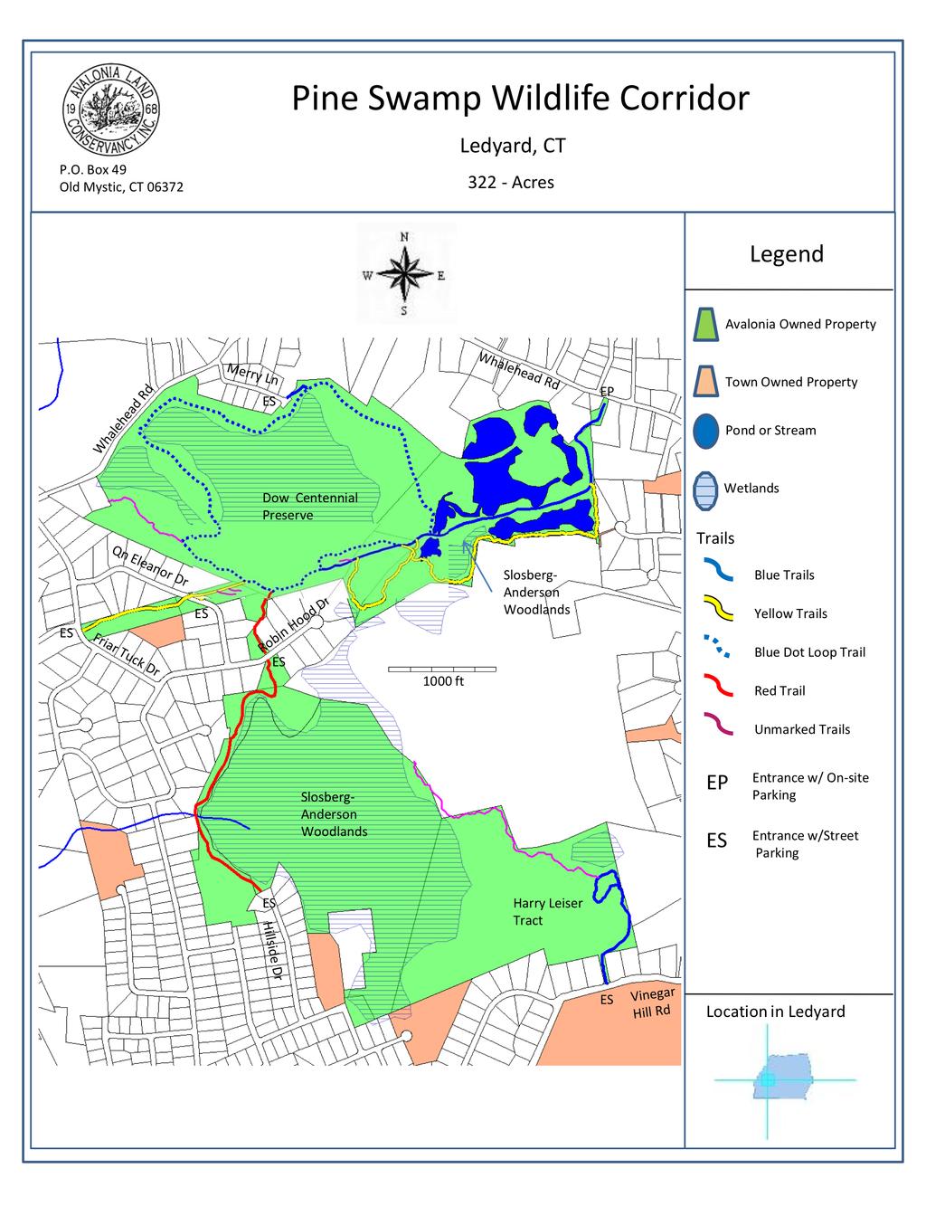
2 OVERVIEW AVALONIA LAND CONSERVANCY, Inc. P.O. Box 49, Old Mystic, CT This plan covers three adjacent properties known as the North Tract (163 acres), the South Tract (104 acres), and the Harry Leiser Tract (56 acres). The North Tract consists of 21 and 21R Friar Tuck Drive; 16, 17 and 17R Queen Eleanor Drive; 41 and 51R Robin Hood Drive; 13A Melanie Lane; and 113 and 201 Whalehead Road. The South Tract consists of 52A and 60R Laurel Leaf Drive; 19 and 20 East Drive; 40 Robin Hood Drive; and 20 Ramblewood Drive. The Harry Leiser Tract is at 114 Vinegar Hill Road. All are in Ledyard, New London County, CT. There is a total of 2.5 miles of trail within the Pine Swamp Wildlife Corridor, accessed via eight different trailheads. See the Avalonia website at for access information. Visitors are welcome. See signs for property access restrictions. All parcels are owned by Avalonia Land Conservancy, Inc. SITE INFORMATION The property Appendix I contains copies of the deeds with the legal description of each property. The Pine Swamp Wildlife Corridor encompasses a variety of habitats, from ponds to swamps to upland forest. There is a major power line right-of-way running across the northern section. The preserve sits over and protects a major aquifer in western Ledyard. The entire preserve is surrounded by land which is zoned for R-40 housing and essentially the entire surrounding area is comprised of residential neighborhoods. The preserve property itself was probably protected from development pressure because it is either too wet or too rocky. The North Tract consists mainly of a large red maple swamp and contains stone walls, an old house site and what appears to be an old dam in the northwestern part of the property. South of this swamp is an area that was used as a sand and gravel operation that was abandoned over 30 years ago. The operations left a number of 1
3 depressions, which have since filled with ground water, as well as spoils from the digging. The vegetation of the power line right-of-way is a dense layer of mostly native shrubs. The heart of the South Tract is another swamp whose name, Pine Swamp, has been applied to the entire preserve. Originally this area was know as the Mast Swamp because it was a ready source of ship masts for the ship-building industry of New London County. The swamp probably supported an extensive stand of Atlantic White Cedar (Chamaecyparis thyoides) and when these were all cut the White Pines (Pinus strobus), which are more prevalent today, became dominant. An article in the New York Times dated November 6, 1883 states, a section of country nearly two miles square, singularly beautiful but made up of morasses and quicksands as treacherous as the Florida Everglades. It is a lovely tract, covered with black ooze mud and water and thickly studded with tall, silvery-green white pines. On the north edge of the Slosberg-Anderson Woodlands lies an area of very large boulders, part of a glacial terminal moraine. Acquisition history The Pine Swamp Wildlife Corridor is comprised of donated parcels as well as parcels that Avalonia purchased. Dow Chemical Corporation donated the first piece of the preserve to Avalonia in 1997, in honor of their centennial. This was the 97+acre red maple swamp that forms the heart of the northern area of the preserve and is known as the Dow Centennial Preserve. In 2003 the descendants of Milton O. Slosberg donated the 79 acre parcel known as the Pine Swamp, and Harry Leiser donated the 56 acres immediately to the east of that. Money was raised to purchase more of the surrounding land from the Slosbergs at the same time. The Town of Ledyard donated four parcels of adjoining property totaling 7.46 acres in The town donated the final pieces of the preserve, two more parcels totaling 7.87 acres, in Property restrictions The only restrictions are those on the Harry Leiser Tract. They are summarized as follows: 1. This parcel must be designated the Harry Leiser Tract 2. It must be forever retained in an undeveloped, natural, open space or wooded condition, without any access roads, picnic tables, fire rings, portable toilets 3. There must be no motorized vehicles 4. Members of the public may walk only on trails which have been constructed with minimal damage to the existing vegetation 5. No hunting or trapping 6. Trees or shrubs should only be cut for the purpose of preventing the spread of disease 2


4 Land use history Please see Appendix II, p. 11. Public use resources The three properties are open to the public for all standard Avalonia passive recreational activities. Bicycle riding and horseback riding are not permitted. The property is posted with use restrictions. Blazed hiking trails are maintained on the northern section and are frequently used. The blue trail can be accessed from Whalehead Road (small parking area) or from Merry Lane (parking in the cul-de-sac). The eastern section of the blue trail follows the power line right-of-way and then turns north and follows the blue dot loop trail around the Dow Centennial preserve. In the southern section there is a single, blazed hiking trail along the western edge of the swamp accessed either from Robin Hood Drive or Hillside Drive (parking in the street at both ends). On the Harry Leiser tract there is a single looped trail accessed from Vinegar Hill Road. Informational sign on Red Trail explaining the glacial moraine. Terminal moraine in Slosberg-Anderson Woodlands 3
5 4
6 Natural resources For a thorough description of the vegetation on the three properties, please see Appendix II, pages Appendix III is a very thorough survey of wildflowers done by two volunteers. The Pine Swamp was most probably originally dominated by Atlantic White Cedar, and although most of these were removed for ship masts several hundred years ago, there are still some remaining in the swamp. Once a common component of peat swamps in southeastern Connecticut, there are very few remaining stands of this tree. It is important that the white cedar present be protected and encouraged to reproduce. There is also a good stand of Rosebay Rhododendron (Rhododendron maximum), the largest native rhododendron, present in the Pine Swamp. The area under the power line has been maintained as a dense shrub layer by the power company. This has created an artificial but effective shrub habitat, which is in steep decline locally. This kind of habitat, however, is important for the breeding success of a number of resident warblers and other birds, and is an important habitat type to maintain. ANIMALS, FISH, AND BIRDS There are no known endangered species on the properties, although the old field and power line habitats combined with the ponds form good habitat for the state-listed Eastern Box Turtle (Terrapene carolina). The predominant large animals on site are whitetail deer which pass through the properties regularly. Unfortunately high deer density favors decreased forest diversity. SOILS AND BEDROCK GEOLOGY Please see Appendix II, pp 8 9 for a discussion of the soils underlying the PSWC. Appendix II also has maps and an in-depth discussion of the soils. HYDROLOGIC FEATURES Please see Appendix II, p. 10, for a discussion of the water resources of the preserve. SPECIAL FEATURES AND CULTURAL RESOURCES Pine Swamp Wildlife Corridor has a number of features which make it unique among Avalonia s Ledyard preserves. The large Pine Swamp with its unique history as well as flora stands out as one of them. This preserve is also the only one to have such large ponds. One of the special features is the area of large boulders which represent the terminal moraine of one of the glaciers which reached southern Connecticut. The boulders are so large and piled so haphazardly that they form caves and dens for large mammals, and also a unique habitat for plants. 5
7 MANAGEMENT OBJECTIVES Stewardship policies Avalonia Land Conservancy Fee Land Stewardship Principles were approved on December 16, 2009 and the document is available at the Conservancy s office on Hatch Street in Mystic, CT. This document sets forth the general principles governing stewardship of all Avalonia properties. The document or any approved successor is hereby incorporated as part of this management plan. Protection As with all Avalonia properties, the exterior boundaries of these preserves shall be marked with approved Avalonia Land Conservancy boundary signs following the guidance given in Avalonia stewardship policies. Entrance signs are currently in place and shall be maintained or replaced as necessary at the eight entrance points to the preserve. An annual walk around the boundaries of the properties is required to ensure that boundary signs are in place and that there are no intrusions. Other surveillance should take place using due vigilance on occasional hikes on the properties. All motorized vehicles are prohibited. All three properties are open to the general public. Visitor controls consist only of posted entrance signs giving accepted activities on the properties. Persons found in violation of these restrictions on use may be asked to leave. If significant problems persist, visitors may be cited for trespass and asked not to come back. Protection of special natural and cultural features has not been an issue to date. The features will be monitored for damage in the future to detect problems. Maintaining properties appearance No mowing has taken place or is planned on these properties. Boundary walls are generally clear of significant plant growth. Trails should be maintained clear of deadfalls on routine hikes through the property. Significant deadfalls should be reported to the Ledyard Town Committee for cleanup. Public use All three tracts are open to the public and hiking trails are maintained for the use of visitors. Motor vehicles, bicycle riding, and horseback riding are not permitted. Hunting and the use of firearms on the property including bow hunting and target practice are not permitted. Camping is not allowed. Dogs must be kept leashed. Visitors are not allowed to pick vegetation or disturb wildlife excessively. Otherwise, the properties are open to all passive recreational activities including fishing in the ponds. 6
8 A parking area is located at 113 Whalehead Road, providing access to the eastern end of the blue trail. Parking is available in the cul-de-sac of Merry Lane for direct access to the blue-dot loop trail. Likewise, road parking is available on Robin Hood Drive or Hillside Drive for access to the red trail. Rules of use signs are posted at all entrances. These signs will be maintained in the future. Trails in the North Tract are blazed in three colors, blue and yellow, the single trail in the South Tract is red-blazed, and the trail in the Harry Leiser tract is blue-blazed. See map on page 4. The blazes are approximately 2 inches wide by 6 inches tall and are rectangular. Where trails are concurrent, both blaze colors are used. There is one interpretive signs on the property at present. This sign is located at the north end of the Red Trail, in the terminal moraine area. It explains the development of this boulder-strewn area and indicates other areas in Ledyard where this kind of feature can be seen. More interpretive signs may be added in the future if found appropriate. Trail maps are available on the Avalonia website: Special events are permitted on the property at the discretion of the Ledyard Town Committee or the Board of Directors. Events to date have consisted of guided hikes on the properties. Enhancing wildlife habitat(s) Maintaining the dense shrub thicket habitat along the power line will be an important priority, as this is a declining habitat in Connecticut, and will continue to be done by the power company. However, Eversource is responsible for maintenance of its right of way. The forestry management plan provided by Connwood suggests creating several small clear cuts to also create some early succession habitat as well as to allow for greater forest diversity. Dead trees should be maintained as snags, providing foraging areas for woodpeckers and cavities for a variety of animals. Controlling invasive species Although large parts of the preserve are essentially free of invasive plants, the areas around the ponds and around the periphery of the red maple swamp in the North Tract do have moderate problems with autumn olive, Japanese Barberry, and oriental bittersweet. These plants should be removed. Erosion control Erosion has not been a significant problem and no action is needed. Productive uses The landscape of swamps and glacial features make any kind of future productive use of this property unlikely, and none is anticipated. 7
9 Scientific and educational activities These are permitted by our deed. The main activities at present are limited to educational guided hikes on the property. Response to large natural disasters The first response to a natural disaster will be to clear away trees and debris from the hiking trails and repair damage to bridges. Logging is permitted to recover trees knocked down or damaged in a major disaster. Special management considerations There are no special management considerations at this time. IMPLEMENTING THE PLAN Recurring and occasional requirements Trail hikes by one or more members of the Ledyard Town Committee should take place on a regular basis to look for and clear deadfalls from the trails and to look for other problems. Our phone number is posted at the entrances so that visitors can contact us for resolution of serious problems such as downed trees, graffiti, dumping, or other damage to the property. Annual obligations A boundary walk around the outside perimeter of all three properties is required to look for intrusions and to ensure that the boundary is marked with Avalonia Land Conservancy signs. Short term plan (1 5 years) The highest priority will be to begin a program of eradication of the invasive plants, especially those surrounding the red maple swamp of the north tract. In the eastern portions there are moderate stands of autumn olive (Eleagnus umbellata). These need to be cut and painted with herbicides, and then continually monitored for regrowth. Further west and along Whalehead Road there is oriental bittersweet (Celastrus orbiculatus) climbing the trees. This needs to be removed before the trees are killed. Also in this area is an extensive area of Japanese barberry (Berberis thunbergerii) that should be removed by manual cutting and painting with herbicides. Long term plan (5+ years) As suggested in the forestry plan prepared by Connwood, early succession habitat should be fostered by cutting several small canopy openings in the forest of the North Tract and creating brush piles. Also, a 8
10 crop-tree release program of removing undesired trees, thus releasing more desirable hardwoods could be undertaken. Schedule for revising this plan This plan shall be reviewed at least every five years and updated as necessary. 9
11 APPENDICES I. Legal documentation a. Survey maps are available at the Hatch Street Office of Avalonia. b. Zoning map for property and surrounding area is available at the Ledyard Town Hall or online at c. Deeds and Restrictions follow II. Forestry Management Plan III. Botany Survey From the Trails of the Pine Swamp Wildlife Corridor in Ledyard, Connecticut by Meredith and Wayne Petrie 10
Stephens Rd. Nature Preserve
 Stephens Rd. Nature Preserve History Stephens Road Nature Preserve (SRNP) is a 350-acre nature preserve in Huntersville that comprises nine properties purchased between 1994 and 2008. Parcels included
Pinellas County Environmental Lands
 Pinellas County Environmental Lands In addition to traditional parks and recreation facilities, Pinellas County owns and manages a system of environmental lands that provides specialized resource-based
CRAZY HORSE TRAIL GUIDE
 CRAZY HORSE TRAIL GUIDE Abridged Version: July 2016 This is a short form of our interpretive trail guide for the Crazy Horse Trail. The full version of the guide has a more detailed description of the
Conservation Area Management Statement
 Conservation Area Management Statement Miller Creek Wildlife Area Resolution #: Approval: Issue Date: Date of Last Revision: Table of Contents 1. Purpose....... 1 2. Property Description...... 1 2.1. Legal
Stephens State Park Trails
 TRAILS OF ALLAMUCHY MOUNTAIN & STEPHENS STATE PARKS Allamuchy Mountain and Stephens State Parks contain 28 marked trails providing access to diverse landscapes for walking, hiking, biking, bird-watching,
This Passport: Revised October 20, 2017, EAM # Discovering the Trails of Penfield, NY
 This Passport: Revised October 20, 2017, EAM #161922 Discovering the Trails of Penfield, NY The Town of Penfield is fortunate to have a wide variety of natural resources which make for many unique and
General Rules for Use of Lands Managed by the. Middle Peninsula Chesapeake Bay Public Access Authority
 General Rules for Use of Lands Managed by the Middle Peninsula Chesapeake Bay Public Access Authority As a visitor to lands managed by the Middle Peninsula Chesapeake Bay Public Access Authority (PAA),
This Passport: Revised October 20, 2017, EAM # Discovering the Trails of Webster, NY
 This Passport: Revised October 20, 2017, EAM #161923 Discovering the Trails of Webster, NY The Town of Webster invites you to explore and experience our diverse outdoor adventures! Here s your opportunity
I N. -..._ Outline of LEDYARD GLACIAL PARK. Kettlehole Trail .., z,,parking. Main Trail. Kettlehole. --* Trail to Bottom of Kettlehole. Stone Wall ,..
 LEDYARD GLACIAL PARK Kettlehole Trail I N T...s, 4, k..., z,,parking.4' Lot -..._ Outline of Kettlehole Main Trail --* Trail to Bottom of Kettlehole Stone Wall,.. LEDYARD GLACIAL PARK Kettlehole Trail
Access: The rocky shoreline is only accessible via private property.
 10. Whale Cove Site description: Whale Cove is a small cove fringed by private homes and condominiums with diverse and relatively undisturbed rocky intertidal and subtidal habitat located approximately
F.O.K.O.S. Friends of Kingston Open Space A GUIDE TO KINGSTON OPEN SPACE
 F.O.K.O.S. Friends of Kingston Open Space A GUIDE TO KINGSTON OPEN SPACE Friends of Kingston Open Space (FOKOS) was formed when a handful of concerned citizens joined together to learn what could be done
Triangle Land Conservancy Conservation Area Monitoring Report Carolina North
 Triangle Land Conservancy Conservation Area Monitoring Report Carolina North Property Name: Bolin Creek West Conservation Area Date of visit: March 16, 2017 County: Orange Property Type: Restrictive Covenants
Conservation Commission Town of Wallingford September 10, 2009 MINUTES
 1 Conservation Commission Town of Wallingford MINUTES The Regular Meeting of the Wallingford Conservation Commission was held on Thursday,, in the Basement Conference Room of the Town Hall Municipal Building,
CELEBRATE WEST GREENWICH GEOCACHING THROUGHOUT WEST GREENWICH
 CELEBRATE WEST GREENWICH GEOCACHING THROUGHOUT WEST GREENWICH The West Greenwich Land Trust (WGLT) is sponsoring Celebrate West Greenwich, an event designed to celebrate the beauty and history of scenic
OWNED LAND ACTIVITIES REPORT February 2012
 OWNED LAND ACTIVITIES REPORT February 2012 BULL RUN MOUNTAINS NATURAL AREA PRESERVE A tremendous number of projects are underway on the Preserve. Currently VOF is working with the Smithsonian Conservation
RATTLESNAKE HILL PHILLIPS, HARRIS FARM, LIME KILN & QUARRY
 Town of, MA Trails Map 6a SPLIT ROCK PRIMARY SECONDARY PRIVATE PRIVATE PROPERY STAY ON HEAD FUTURE TO SKINNER (NOT MARKED) 0 miles 0.25 0.250 0.5 Mapbox, Data Odbl, OpenStreetMap contributors primary use
3.0 EXISTING PARK & RECREATION SPACE
 3.0 EXISTING PARK & RECREATION SPACE TOWN PARK & RECREATION SPACE An inventory of current parks and recreation area in the Town of Cedarburg is shown in Table 3. These areas total roughly 381.89 acres.
Santa Clara South Hills Recreation Park Project Development and Management Plan
 Santa Clara South Hills Recreation Park Project Application for Land for Recreation or Public Purposes, City of Santa Clara, Utah Prepared for: Bureau of Land Management, St. George Field Office 345 East
National Forests and Grasslands in Texas
 United States Department of Agriculture Forest Service National Forests and Grasslands in Texas Sam Houston NF 394 FM 1375 West New Waverly, Texas 77358 Phone 936-344-6205 Dear Friends, File Code: 1950
The Chu property is a 6.57 acre parcel located in the Town of Superior on the west side of McCaslin Boulevard. In 2014, the Town of Superior acquired
 1 The Chu property is a 6.57 acre parcel located in the Town of Superior on the west side of McCaslin Boulevard. In 2014, the Town of Superior acquired the Chu property for open space with a contribution
Pembina Valley Provincial Park. Draft Management Plan
 Pembina Valley Provincial Park Draft Management Plan 2 Pembina Valley Provincial Park Table of Contents 1. Introduction... 3 2. Park History... 3 3. Park Attributes... 3 3.1 Natural... 3 3.2 Recreational...
Connie Rudd Superintendent, Black Canyon of the Gunnison National Park
 National Park Service U.S. Department of the Interior Black Canyon of the Gunnison National Park and Curecanti National Recreation Area Information Brochure #1 Wilderness and Backcountry Management Plan
Nov. 19 th Public Workshop Summary
 On November 19 th, more than 60 community members attended an Open Space Matters workshop at the Linen Building in downtown Boise for over two hours. Participants learned about reserves, discussed the
Triangle Land Conservancy Conservation Area Monitoring Report Carolina North
 Triangle Land Conservancy Conservation Area Monitoring Report Carolina North Property Name: Bolin Creek East Conservation Area Date of visit: March 16, 2017 County: Orange Property Type: Restrictive Covenants
Alternative 3 Prohibit Road Construction, Reconstruction, and Timber Harvest Except for Stewardship Purposes B Within Inventoried Roadless Areas
 Roadless Area Conservation FEIS Summary Table S-1. Comparison of Key Characteristics and Effects by Prohibition Alternative. The effects summarized in this table A would occur in inventoried roadless areas
Triangle Land Conservancy Conservation Area Monitoring Report Carolina North
 Triangle Land Conservancy Conservation Area Monitoring Report Carolina North Property Name: Crow Branch Conservation Area Date of visit: March 16, 2016 County: Orange Property Type: Restrictive Covenants
ANAGEMENT. LAN November, 1996
 M ANAGEMENT P LAN November, 1996 for Paul Lake Provincial Park Ministry of Environment, Lands and Parks BC Parks Department Paul Lake Provincial Park M ANAGEMENT P LAN Prepared by BC Parks Kamloops Area
MORGAN CREEK GREENWAY Final Report APPENDICES
 APPENDICES MORGAN CREEK GREENWAY Appendix A Photos of Existing Conditions in Trail Corridor Photos of existing conditions Main trail corridor - February 2009 Photos of existing conditions south bank Morgan
Yard Creek Provincial Park. Management Plan
 Yard Creek Provincial Park Management Plan Draft January 2010 Yard Creek Provincial Park Management Plan Approved by: telàlsemkin/siyam/chief Scott Benton Bill Williams Squamish Executive Director ation
Preferred Recreation Recommendations Stemilt-Squilchuck Recreation Plan March 2018
 Preferred Recreation Recommendations Stemilt-Squilchuck Recreation Plan March 2018 Below are the recommended recreation ideas and strategies that package together the various recreation concepts compiled
DOYLE SPRINGS PLANNING UNIT Kern-Tule River Watershed
 Existing Conditions & Uses Overview Consists of a mostly forested parcel with small hydropower developments and part of a private recreation cabin development, along with two small transmission line corridor
Site description: 2.7 miles of intertidal habitat located about 2 miles north of Depoe Bay in Lincoln County, Oregon (Figure 16).
.") 8 Boiler Bay Site description: 27 miles of intertidal habitat located about 2 miles north of Depoe Bay in Lincoln County, Oregon (Figure 16) Designation: Boiler Bay was a research reserve before TSP publication,
8 Boiler Bay Site description: 27 miles of intertidal habitat located about 2 miles north of Depoe Bay in Lincoln County, Oregon (Figure 16) Designation: Boiler Bay was a research reserve before TSP publication,
Marchand Provincial Park. Management Plan
 Marchand Provincial Park Management Plan 2 Marchand Provincial Park Table of Contents 1. Introduction... 3 2. Park History... 3 3. Park Attributes... 4 3.1 Natural... 4 3.2 Recreational... 4 3.3 Additional
DECISION MEMO. Rawhide Trail #7073 Maintenance and Reconstruction
 Page 1 of 6 Background DECISION MEMO USDA Forest Service Jefferson Ranger District Jefferson County, Montana Rawhide Trail #7073 is located in the Elkhorn Mountain Range approximately 10 miles east of
Hiawatha National Forest St. Ignace Ranger District. File Code: 1950 Date: August 5, 2011
 United States Department of Agriculture Forest Service Hiawatha National Forest St. Ignace Ranger District W1900 West US-2 St. Ignace, MI 49781 906-643-7900 File Code: 1950 Date: August 5, 2011 Dear National
Moraine Valley Community College Campus Tree Care Plan Table of Contents
 Moraine Valley Community College Campus Tree Care Plan 2016-2021 Table of Contents I. CAMPUS TREE CARE PLAN PURPOSE:... 1 II. RESPONSIBLE DEPARTMENT... 1 III. THE CAMPUS TREE ADVISORY COMMITTEE... 1 IV.
Understanding user expectations And planning for long term sustainability 1
 Understanding user expectations And planning for long term sustainability 1 What is a natural surface trail? It can be as simple has a mineral soil, mulched or graveled pathway, or as developed as elevated
Dungeness Recreation Area County Park Master Plan
 Dungeness Recreation Area County Park Public Outreach Meeting October 10, 2007 Project Overview USFWS Site Dungeness Recreation Area County Park Meeting Objectives: Re-Introduce project; provide status
USDA Forest Service Deschutes National Forest DECISION MEMO. Round Lake Christian Camp Master Plan for Reconstruction and New Facilities
 USDA Forest Service Deschutes National Forest DECISION MEMO Round Lake Christian Camp Master Plan for Reconstruction and New Facilities Jefferson County, Oregon T. 13 S., R. 8 E., Section 16, W.M. Background:
NAVAJO COMMUNITY PLAN
 NAVAJO COMMUNITY PLAN Prepared by the NAVAJO COMMUNITY PLANNERS and THE CITY OF SAN DIEGO City of San Diego Planning Department 202 C Street, MS 4A San Diego, CA 92101 Printed on recycled paper. This information,
THOMAS A. SWIFT METROPARK Introductions History Present Conditions Future Development Plans Implementation Strategies Statistics
 THOMAS A. SWIFT METROPARK Introductions History Present Conditions Future Development Plans Implementation Strategies Statistics Introduction As an open meadow park positioned along the Mahoning River,
Wilderness Areas Designated by the White Pine County bill
 Wilderness Areas Designated by the White Pine County bill SEC. 321. SHORT TITLE. This subtitle may be cited as the `Pam White Wilderness Act of 2006'. SEC. 322. FINDINGS. Congress finds that-- The White
Brooker Creek Preserve Management Plan 2008 Update
 Brooker Creek Preserve Management Plan 2008 Update Plan approved by the Board of County Commissioners Pinellas County, Florida 19 August 2008 Pinellas County Department of Environmental Management Environmental
Theme: Predominately natural/natural appearing; rustic improvements to protect resources. Size*: 2,500 + acres Infrastructure**:
 Recreation Opportunity Spectrum (ROS) Classes The Recreation Opportunity Spectrum (ROS) provides a way to describe the variations in the degree of isolation from the sounds and influences of people, and
Geoscape Toronto The Oak Ridges Moraine Activity 2 - Page 1 of 10 Information Bulletin
 About 13,000 years ago as the Laurentide Ice Sheet melted, glacial meltwater accumulated between the ice sheet and the Niagara Escarpment. This formed a lake basin into which gravel and sand were deposited.
Triangle Land Conservancy Conservation Area Monitoring Report Carolina North
 Triangle Land Conservancy Conservation Area Monitoring Report Carolina North Property Name: Crow Branch Conservation Area Date of visit: 4/8/2015 County: Orange Property Type: Restrictive Covenants Local
Triangle Land Conservancy Conservation Area Monitoring Report Carolina North
 Triangle Land Conservancy Conservation Area Monitoring Report Carolina North Property Name: Bolin Creek East Conservation Area Date of visit: 4/8/2015 County: Orange Property Type: Restrictive Covenants
Wetlands Reservoirs of Biodiversity. Billy McCord, SCDNR
 Wetlands Reservoirs of Biodiversity Billy McCord, SCDNR Estuaries Tidal Deepwater Intertidal Salt Marsh Tidal Riverine Fresh & Brackish Deepwater Tidal Emergent Marsh Freshwater Riverine Seasonally Flooded
Rule Governing the Designation and Establishment of All-Terrain Vehicle Use Trails on State Land
 Rule Governing the Designation and Establishment of All-Terrain Vehicle Use Trails on State Land 1.0 Authority 1.1 This rule is promulgated pursuant to 23 V.S.A. 3506. Section 3506 (b)(4) states that an
The Old Foundation. Glacial Rocks. Types of Trees
 The Old Foundation Back in the 1920s, real estate speculators created a housing development here, known as the Metuchen Manor. Many lots were sold in this area. However in the 1930s, during the Great Depression,
Chapter 9 Recreation
 Chapter 9 Chapter 9 1.0 INTRODUCTION The Town of Littleton is within one of New England s most important recreation areas. More than three million people live within 100 miles of the area. Local residents
Procedure for the Use of Power-Driven Mobility Devices on Mass Audubon Sanctuaries 1 September 17, 2012
 Procedure for the Use of Power-Driven Mobility Devices on Mass Audubon Sanctuaries 1 September 17, 2012 Background As part of Mass Audubon s mission to preserve the nature of Massachusetts for people and
ISLAND PARK MANAGEMENT PLAN AND GUIDELINES
 ISLAND PARK MANAGEMENT PLAN AND GUIDELINES - 2015 Introduction Island Park was a sand dune on the edge of Lake Huron 12,000 years ago. As the lake receded, it left a river channel, the Thunder Bay River.
Business Item No
 Metropolitan Parks and Open Space Commission Meeting date: February 6, 2018 For the Community Development Committee meeting of February 20, 2018 For the Metropolitan Council meeting of February 28, 2018
MANAGEMENT DIRECTION STATEMENT June, 1999
 Thompson River District MANAGEMENT DIRECTION STATEMENT June, 1999 for Roche Lake Provincial Park Ministry of Environment Lands and Parks BC Parks Division Table of Contents I. Introduction A. Setting
Ragged Mountain Natural Area. Public Planning Meeting #1 February 29 th, 2016
 Ragged Mountain Natural Area Public Planning Meeting #1 February 29 th, 2016 Planning During dam construction P&R approached by various groups asking if the rules would be changed once the dam was complete
Bon Portage Island Conservation Campaign
 Bon Portage Island Conservation Campaign Protecting a Coastal Treasure Final Report to Nova Scotia Habitat Conservation Fund September 2012 Protection of Bon Portage Island Over the course of this two-year
City of Durango 5.8 FUNDING TRAILS DEVELOPMENT
 5.8 FUNDING TRAILS DEVELOPMENT The City has been successful in establishing dedicated local funding sources as well as applying for grants to develop the City s trail system, having received nearly $2.4
Public Comment. Comment To consider extending State Park lands above River Mile 7.0
 Public To consider extending Park lands above River Mile 7.0 on the Little Spokane River for the conservation and limited recreation qualities they contain is this request. Could this be included in your
Northeast Quadrant Distinctive Features
 NORTHEAST QUADRANT Northeast Quadrant Distinctive Features LAND USE The Northeast Quadrant includes all the area within the planning area that is east of Interstate 5 and to the north of State Route 44.
Malua Biobank Operations Report. Submitted by the Sabah Forestry Department May June 2009
 Malua Biobank Operations Report Submitted by the Sabah Forestry Department May 2009 - June 2009 Protection Boundary monitoring and patrol, gate installations, signage installation and maintenance, night
MANAGEMENT DIRECTION STATEMENT June, 1999
 Thompson River District MANAGEMENT DIRECTION STATEMENT June, 1999 for Clearwater River Corridor (Addition to Wells Gray Park) Ministry of Environment Lands and Parks BC Parks Division ii Table of Contents
Wow! Have you seen our new website! Same address: gctrust.org, great new look!
 Wow! Have you seen our new website! Same address: gctrust.org, great new look! Your donation to the GCT helps us manage over 1500 acres of conservation lands, protecting valuable habitat and creating recreational
IOWA ORNITHOLOGISTS' UNION - Birding Sites in Dallas County
 IOWA ORNITHOLOGISTS' UNION - Birding Sites in Dallas County Printed on 7/19/2018 Beaver Bottoms Wetland (restricted) (Important Bird Area) GPS Coordinates:, Ownership: Private (see directions for access)
STOWER SEVEN LAKES STATE RECREATION TRAIL POLK COUNTY, WISCONSIN. MASTER PLAN June, 2018
 STOWER SEVEN LAKES STATE RECREATION TRAIL POLK COUNTY, WISCONSIN MASTER PLAN June, 2018 Polk County Environmental Services Committee Kim O Connell-Chairman Brad Olson -Vice Chairman Jim Edgell Doug Route
Bear Creek Habitat Improvement Project
 06/10/10 Bear Creek Habitat Improvement Project El Paso County, Colorado Pike National Forest and Colorado Springs Utilities Owned Land Report prepared by: Eric Billmeyer Executive Director Rocky Mountain
Mackinnon Esker Ecological Reserve Draft - Management Plan
 Mackinnon Esker Ecological Reserve Draft - Management Plan May 2011 Photo Credit: This document replaces the direction provided in the Carp Lake Provincial Park and Protected Area and Mackinnon Esker Ecological
Blue River Trail Master Plan JSA to Town Hall June 2004
 Blue River Trail Master Plan JSA to Town Hall June 2004 Prepared for: Silverthorne Town Council Silverthorne SPORT Committee Department of Recreation and Culture Silverthorne Public Works Silverthorne
THAT the Board approve the final proposed concept plan for the Jericho Marginal Wharf site as shown in Figure C-4 of Appendix C.
 Date: January 17, 2012 TO: Board Members Vancouver Park Board FROM: General Manager Parks and Recreation SUBJECT: Jericho Marginal Wharf Phase 2 Concept Plan RECOMMENDATION THAT the Board approve the final
Region 1 Piney Woods
 Region 1 Piney Woods Piney Woods 1. This ecoregion is found in East Texas. 2. Climate: average annual rainfall of 36 to 50 inches is fairly uniformly distributed throughout the year, and humidity and temperatures
Final Recreation Report. Sunflower Allotment Grazing Analysis. July 2015
 Final Recreation Report Sunflower Allotment Grazing Analysis July 2015 Table of Contents Introduction... 3 Affected Environment... 3 Four Peaks Wilderness Area... 3 Dispersed Recreation... 3 Environmental
Silver-washed Fritillaries in the Straits Inclosure in July
 ALICE HOLT FOREST Hampshire from www.discoverbutterflies.com the website for the book Discover Butterflies in Britain D E Newland Silver-washed Fritillaries in the Straits Inclosure in July Alice Holt
PASSPORT. Discovering the Trails of Webster, NY
 PASSPORT to family wellness Discovering the Trails of Webster, NY Join the Friends of Webster Trails, Webster Health and Education Network, The Town of Webster and Wegmans to get moving more and enjoy
Terrestrial Protected Area Nomination: Central Mangrove Wetland South-West, Grand Cayman
 Terrestrial Protected Area Nomination: Central Mangrove Wetland South-West, Grand Cayman The attached nomination, proposing that a parcel of land in the Central Mangrove Wetland be made a Protected Area
CHAPTER III: TRAIL DESIGN STANDARDS, SPECIFICATIONS & PERMITS
 CHAPTER III Trail Design Standards, Specifications & Permits This chapter discusses trail standards, preferred surface types for different activities, permits, and other requirements one must consider
Langton Lake Park Implementation Planning Session One 6 June Attendees signed in
 27 Attendees signed in Meeting summary Following an overview of the Parks and Recreation Renewal Program and the key directions of the Parks and Recreation System Master Plan, meeting participants were
Silver Lake Park An Environmental Jewel for the Citizens of Prince William County
 Silver Lake Park An Environmental Jewel for the Citizens of Prince William County The Prince William Park Authority Mission Statement states: The Prince William County Park Authority will create quality
CHAPTER 5. Chapter 5 Recreation Element
 CHAPTER 5 Recreation Element Chapter 5 Recreation Element The Recreation Element of the Meyers Area Plan is a supplement to the Recreation Element of the TRPA Regional Plan and the El Dorado County General
EDGEWILD TRAIL Non Motorized Trail PROPOSED DEVELOPMENT PROJECT
 EDGEWILD TRAIL Non Motorized Trail PROPOSED DEVELOPMENT PROJECT SESW, SWSE Section 15, NWNE, NENW, SWNE, SENE Section 22, Township 138, Range 27 (City of Fifty Lakes) Crow Wing County Land Services Department
Numaykoos Lake Provincial Park. Management Plan
 Numaykoos Lake Provincial Park Management Plan 2 Numaykoos Lake Provincial Park Table of Contents 1. Introduction... 3 2. Background... 3 3. Park Purpose... 5 4. Park Management Guidelines... 6 Appendix...
Special Recreation Management Areas Extensive Recreation Management Areas Public Lands Not Designated as Recreation Management Areas
 From the Proposed RMP: Special Recreation Management Areas SRMAs are an administrative unit where the existing or proposed recreation opportunities and recreation setting characteristics are recognized
Whitemouth Falls Provincial Park. Draft Management Plan
 Whitemouth Falls Provincial Park Draft Management Plan Whitemouth Falls Provincial Park Draft Management Plan Table of Contents 1. Introduction... 3 2. Park History... 3 3. Park Attributes... 4 3.1 Natural...
Open Space Index. Town of Philipstown. Adopted January 8, Submitted by: Philipstown Conservation Advisory Committee
 Open Space Index Town of Philipstown Adopted January 8, 2009 Submitted by: Philipstown Conservation Advisory Committee Acting Chair Eric Lind Mark Galezo Andy Galler Lew Kingsley Mike Leonard MJ Martin
Birch Point Provincial Park. Management Plan
 Birch Point Provincial Park Management Plan 2 Birch Point Provincial Park Table of Contents 1. Introduction... 3 2. Park History... 3 3. Park Attributes... 4 3.1 Natural... 4 3.2 Recreational... 4 4. Park
ANAGEMENT P LAN. February, for Elk Lakes and Height of the Rockies Provincial Parks. Ministry of Environment, Lands and Parks BC Parks Division
 M ANAGEMENT P LAN February, 1999 for Elk Lakes and Height of the Rockies Provincial Parks Ministry of Environment, Lands and Parks BC Parks Division Elk Lakes & Height of the Rockies Provincial Parks M
~,t;b i D34 Vs33 SB 482
 ., SB 482 ~,t;b i D34 Vs33 This document is made available electronically by the Minnesota Legislative Reference Library as part of an ongoing digital archiving project. http://www.leg.state.mn.us/lrl/lrl.asp
MINIMUM REQUIREMENTS DECISION GUIDE WORKSHEETS
 ARTHUR CARHART NATIONAL WILDERNESS TRAINING CENTER MINIMUM REQUIREMENTS DECISION GUIDE WORKSHEETS Fuel Maintenance Around Red-cockaded Woodpecker Trees on Islands within the Okefenokee Wilderness Area....
Skyland Ranch. At a Glance: Property Features
 Property Features Ideally positioned in an ox box of the mighty Apalachicola River, Skyland Ranch s 2 ½ miles of river frontage form the foundation of this distinctive property. Coveted by recreational
Assessing Your Trails, Keeping Them Safe and Enjoyable
 Jon Wood, PLA, ASLA Associate Vice President Stewart Bert Lynn, PLA, ASLA, LEED AP Project Manager Mecklenburg County Asset and Facility Management Assessing Your Trails, Keeping Them Safe and Enjoyable
Tranquil Wood Rhewl, near Ruthin, Denbighshire acres of medal-winning hardwoods for 26,500 (freehold)
") WOODS 4 SALE Phone: 01248 364 362 www.woods4sale.co.uk UK Woodland & Woods For Sale: Specialising in the Sales of Small Woodlands in England, Scotland and Wales for Recreation, Wildlife Conservation and
WOODS 4 SALE Phone: 01248 364 362 www.woods4sale.co.uk UK Woodland & Woods For Sale: Specialising in the Sales of Small Woodlands in England, Scotland and Wales for Recreation, Wildlife Conservation and
Management Plan For Mills Riverside Park
 DRAFT Management Plan For Adopted Prepared by: Jericho Underhill Park District P. O. Box 164 Underhill, VT 05489 Table of Contents Purpose... 3 History... 4 General Description of the Property... 5 Trail
MASTER PLAN EXECUTIVE SUMMARY
 Biscuit Run State Park Scottsville Road (State Route 20) Charlottesville, VA 22902 Biscuit Run State Park MASTER PLAN EXECUTIVE SUMMARY Department of Conservation and Recreation Division of Planning and
Welcome and thank you for being here! Kick-Off Public Workshop November 19, 2014
 Welcome and thank you for being here! Kick-Off Public Workshop November 19, 2014 OPEN SPACE MATTERS: Boise s First Reserve Master Plan Julia Grant Foothills and Open Space Manager City of Boise Ellen Campfield
Map 1.1 Wenatchee Watershed Land Ownership
 Map 1.1 Wenatchee Watershed Land Ownership Map 1.1 Wenatchee Watershed Land Ownership The Wenatchee watershed lies in the heart of Washington state in Chelan County. Just larger than the state of Rhode
Proposed Scotchman Peaks Wilderness Act 2016 (S.3531)
") 1 Proposed Scotchman Peaks Wilderness Act 2016 (S.3531) Frequently Asked Questions PLACE Where is the area that would be designated as Wilderness? The lands outlined in S.3531 lie within Idaho along its
1 Proposed Scotchman Peaks Wilderness Act 2016 (S.3531) Frequently Asked Questions PLACE Where is the area that would be designated as Wilderness? The lands outlined in S.3531 lie within Idaho along its
Fossil Creek Wild & Scenic River Comprehensive River Management Plan Forest Service Proposed Action - details March 28, 2011
 Fossil Creek Wild & Scenic River Comprehensive River Management Plan Forest Service Proposed Action - details March 28, 2011 Primary Goals of the Proposed Action 1. Maintain or enhance ORVs primarily by
National Park Service Wilderness Action Plan
 National Park Service U.S. Department of the Interior National Park Service Wilderness Action Plan National Wilderness Steering Committee National Park Service "The mountains can be reached in all seasons.
2.0 Physical Characteristics
 _ 2.0 Physical Characteristics 2.1 Existing Land Use for the Project The site is comprised of approximately 114 acres bounded by Highway 101 to the north, the existing town of Los Alamos to the east, State
Bayview Escarpment. Interim Management Statement
 Bayview Escarpment Interim Management Statement Bayview Escarpment Provincial Nature Reserve Interim Management Statement January 15, 1995 REGIONAL DIRECTOR'S APPROVAL STATEMENT This Interim Management
Vermont Cows by Peter Salmon
 Vermont Cows by Peter Salmon SUSTAINABLE FOREST & PROPERTY MANAGEMENT: At current the Dorset Town Forest includes the 30 acre parcel that sits atop Owl s Head peak in Dorset. By acquiring this property