Ragged Mountain Natural Area. Public Planning Meeting #1 February 29 th, 2016
|
|
|
- Richard Owens
- 5 years ago
- Views:
Transcription

1 Ragged Mountain Natural Area Public Planning Meeting #1 February 29 th, 2016
2 Planning During dam construction P&R approached by various groups asking if the rules would be changed once the dam was complete Public meeting held Nov 2014 had consensus for shared use if done appropriately City Council discussion 2015 with shared use approved in concept but desire to get more public input and ecological study Staff instructed to undertake planning process and return to council

3 Land Area 980 acres total ~680 acres north of I-64 ~300 acres south of I-64 Lake is 170 acres (at capacity)

4 History (non land use) Subsistence farming scattered along mountains south of Charlottesville (~to Plank Road) Edgar Allen Poe wild and dreary A Tale of the Ragged Mountains mid 1820 s 1912 Investigation into the conditions in the Ragged Mountains UVA Civic club Study on the persons living in the broader Ragged Mountain area (not specifically the reservoir)

5 Ragged Mountain Reservoir S Upper dam built in 1887 S Lower dam built in 1920s S Expanded Ragged Mountain Reservoir completed in 2014
6 Ragged Mountain Reservoir S $26.9 million construction budget S 670,000 cubic yards of dirt placed S 4,400 tons of gravel used S 129 feet tall

7 Ragged Mountain Reservoir S 1.54 billion gallons S 170 acres S 1.8 square mile watershed

8 Not to scale

9 RWSA Urban Area Water Sources Three Reservoirs Ragged Mountain -1.5 BG South Rivanna -800 MG Sugar Hollow 324 MG One River Intake North Rivanna


10 Old reservoir (O-hill) 1850 s Fed a water tank in the Rotunda Water used for everything except drinking

11 1885 Reservoir at Ragged


12 Sugar Hollow Pipeline Connects SH to RM 13.5 mile pipeline 18 inch cast iron pipe Tunnel Pump box canal to upper lake


13 1908 construction concrete dam All photos from Holsinger collection online at UVA library
14 Rivanna Water and Sewer Authority Formed as a regional entity in 1973 Four-party agreement City, County, RWSA, ACSA Took over management of water supply, but not land around reservoir Defines use rules for lake based on water supply needs and state/federal laws
15 Public Access Pre 1990 s mostly for fishing only 1990 s Ivy Creek Foundation created trails for hiking Original lower parking lot includes trail easement from Hedgrwow (Heyward) to access lake New parking lot is on city property All public access is from reservoir road Ednam entry is private for Ednam residents only
16 Fishing and boating Boats are allowed but no gasoline engines Canoe, kayak, etc. Fishing allowed with state license DGIF patrols and monitors this activity Ramp is not currently public, part of this planning discussion will be to identify how to create better boat access

17 Animal control Dogs are not allowed at Ragged Mountain Sign stating no pets allowed is on site and on the City website Animal control was shown the property in December 2015 and will go to the site at least every two weeks or more often as available.
18 Forestry Selective cut Between 1954 and 1958, 2½ million board feet of lumber were removed, with sale proceeds going to the City. No commercial timber harvesting has taken place since then. Trees along the lake shore were removed up to the interim lake level in to allow for reservoir expansion.
19 Recent reservoir expansion Part of approved water supply plan Lake area increased from 74 acres to 170 Deepest part is 100 feet Lake has rock habitat for fish Lake level was lowered during construction and nearly all material for new dam is from on-site RWSA purchased trail toolshed and floating bridge to support trails at the site


20 Reservoir Expansion Before, During, and After

21 Reservoir pre and post expansion

22 Changes during construction Caretaker house removed had not been occupied since 2007 Upper gravel parking lot created during construction left in place for public use Boat ramp is the haul road leftover from dam construction


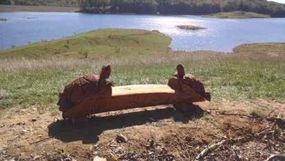
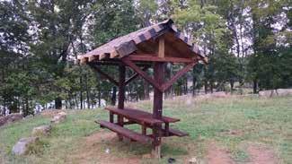
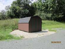
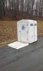
23 Small Bridge Picnic tables Port-o-potty Kiosk and signs Chainsaw art Other amenities

24 Land replacement Albemarle County paid $750,000 for land lost to higher lake elevation (~100 acres) City Parks has acquired three undeveloped properties along Moore s Creek with this $$ Hartman Mill -20 acres - behind Edgecomb Quarry Park - 12 acres Moores creek near Rt. 20 Fornes - 30 acres- across O.L.R. from Azalea Park
25 Land expansion efforts Working with adjacent property owners Acquire adjacent undeveloped parcels if possible Establish legal access to portions of upper road Establish legal access to trails on CHT property Working to determine if tunnel under I-64 on adjacent private properties could possibly be used to access land on south side of interstate.


26 UVa & Foundation properties Boar s head Inn, Foxhaven Farm and Birdwood Golf course properties have trails
27 Trail construction Ivy Creek Foundation built initial trails in 1990s Portion of trails lost due to higher lake elevation Parks & Rec took lead to restore lost trails by connecting existing trails with new trail links where inundated. Mostly volunteer work led by city staff Same trail style and construction as Ivy Creek Natural surface, 1-2 foot wide, along contours RTF/Appalachian Trail experience

28 Trail Restoration Plan (2014) Restore lost portions of trail and connect to original trails to complete loop around lake Provide access to location for floating bridge Did not include full lakeshore perimeter trail, some areas left for nature only Staff has ceased trail construction until planning process and environmental studies are complete


29 Trail construction Trails follow contour of land and do not run up and down hills to reduce potential for erosion. Trails go around large trees and avoid sensitive environmental areas such as wetlands to reduce impact to ecology and resources.

30 Upper maintenance road Original road bed to the south Used by RWSA to access old upper dam Still in place and used by Parks for vehicle access for maintenance and bio-blitz Working to obtain legal public access due to wandering fence/property lines


31 Floating Bridge Bridge will be installed by RWSA later this year to complete the trail loop
32 City Park Classification Natural Resource Management Areas: Purpose: Natural Resource Management Areas are primarily designated for natural resource protection and stewardship. These areas may include forested areas, stream valleys, wetlands, and wildlife habitat. Primary intention is for protection of natural resources with a secondary use for passive recreation, interpretation, and education. Location and Access: These areas can be located anywhere throughout the City, and may include water reservoir properties. Size can range from 1-1,000 acres or more depending on setting and location. Access is generally available from local connector trails or small parking lot trailhead areas. Access into the park itself is primarily on foot. Character and Extend of Development: Natural Resource Management Areas provide opportunity to enjoy natural resources in and around the urban area. These areas typically do not include spaces for active recreation such as athletic fields, playgrounds, etc. Buildings, other than small restrooms or picnic shelters, are generally not included in these areas. Lighting is not generally included in these areas but may be included at parking and trailhead areas. These lands may be placed into conservation or open space easements to preserve natural features, but easements are not required. Fishing is allowed but not hunting or trapping. Forest management is intended to preserve native plants and control invasive plant species. Natural Resource Management Areas in and around the City include Ragged Mountain, Ivy Creek Natural Area, Sugar Hollow Reservoir, and the Meadow Creek Stream Valley. Additional properties may be added to this classification as acquired.

33 Ivy Creek Foundation establishment of RMNA

34 Ivy Creek Foundation discussion on transfer of management to City Parks City now has staff and resources not available in 1990s to manage the site ICF has much work to do at Ivy Creek, and can potentially use the same effort at Arrowhead and other new County properties to open trails sooner than the County might be able to Board voted in Sept to release itself from management obligation at Ragged, but retains right to run environmental programs and help with trail construction and maintenance


35 1998 Study of Ragged Mountain Performed by Ivy Creek Foundation Dan Bieker and others Includes brief biological inventory of area s plant and wildlife resources Survey route followed proposed trail locations No threatened or endangered species were encountered

36 VA Dept. of Conservation & Recreation Division of Natural Heritage Ragged Mountain is listed as: Managed meaning it is public Cultural chimney foundations Ecological Core is General Forest Economy is Very High (harvest value) Watershed integrity Moderate to High Vulnerabiltiy highest based on generic development pressure


37 Bio Blitz Began in 2014 at request of Parks Staff Performed by volunteers Multiple visits to site over past year Identifying and mapping plants and animals that may warrant further study Some points may be negative such as invasives This effort is now complete Visit inaturalist website to see more information /ragged-mountains-bioblitz
38 Ecosystem Survey and Assessment City is providing a stipend to Center for Urban Habitats to learn about what types of ecosystems are there and where they are. Different ecosystems support different plants and animals, and some warrant different treatment from the vantage point of interpretation, education and protection. The first step is to classify all ecosystems. Ecosystems have names, and some are more biologically at-risk than others. If we know what is on the land and where, and the many different types of biota (plants and animals) that live in each, we can make wise decisions about where to put trails (or where not to), how to use trails, and what education focal points there are. The results of the survey will provide lists of birds, trees and shrubs, flowering plants, ferns, and even butterflies, dragonflies and other animals.

39 DRAFT Ecosystem map Landscape is dominated by Piedmont Basic Oak-Hickory Forest with occasional Acidic Oak-Hickory on ridge tops, Oak and Pine Heath on northwest slopes and a mix of degraded landscapes and exceptionally rich habitat types scattered throughout. More unique areas are in hollows and near lake shore Heavily disturbed areas have been replanted and will be monitored over time. These areas can be follow-up planted as needed to ensure establishment of proper land cover and trees.
40 Future meetings and process March 22, 6pm public input (open mic night) April 6 6pm discussion of allowable uses and trail layout A draft plan will be created and aligned with the ecological study results
41 Plan Approval process Final draft plan developed in public meetings will be reviewed in public hearing with 30 day comment period by the P&R Advisory Board Planning Commission will be asked to review and comment on the plan City Council has final vote on plan (summer)
42 Questions? This presentation and other information will be available on the website starting tomorrow at Comments can be sent at any time to: Leave a message on the park planning hotline Mail to Parks and Rec c/o Ragged Mountain 501 East Main Street Charlottesville, VA 22902
Pinellas County Environmental Lands
 Pinellas County Environmental Lands In addition to traditional parks and recreation facilities, Pinellas County owns and manages a system of environmental lands that provides specialized resource-based
Niagara Natural Heritage Park
 A Future Proposal For the Niagara-on-the-Lake DND Lands....... Parks Canada Lakeshore Road Property 1 May, 2016 The Harmony Residents Group We are proposing a Natural Heritage Park be established on the
MASTER PLAN EXECUTIVE SUMMARY
 Biscuit Run State Park Scottsville Road (State Route 20) Charlottesville, VA 22902 Biscuit Run State Park MASTER PLAN EXECUTIVE SUMMARY Department of Conservation and Recreation Division of Planning and
Silver Lake Park An Environmental Jewel for the Citizens of Prince William County
 Silver Lake Park An Environmental Jewel for the Citizens of Prince William County The Prince William Park Authority Mission Statement states: The Prince William County Park Authority will create quality
METROPOLITAN COUNCIL 390 North Robert Street, St. Paul, MN Phone (651) TDD (651)
 TDD (651)") DATE: March 27, 2012 METROPOLITAN COUNCIL 390 North Robert Street, St. Paul, MN 55101 Phone (651) 602-1000 TDD (651) 291-0904 TO: Metropolitan Parks and Open Space Commission FROM: Arne Stefferud, Planning
DATE: March 27, 2012 METROPOLITAN COUNCIL 390 North Robert Street, St. Paul, MN 55101 Phone (651) 602-1000 TDD (651) 291-0904 TO: Metropolitan Parks and Open Space Commission FROM: Arne Stefferud, Planning
Preferred Recreation Recommendations Stemilt-Squilchuck Recreation Plan March 2018
 Preferred Recreation Recommendations Stemilt-Squilchuck Recreation Plan March 2018 Below are the recommended recreation ideas and strategies that package together the various recreation concepts compiled
This Passport: Revised October 20, 2017, EAM # Discovering the Trails of Webster, NY
 This Passport: Revised October 20, 2017, EAM #161923 Discovering the Trails of Webster, NY The Town of Webster invites you to explore and experience our diverse outdoor adventures! Here s your opportunity
OWNED LAND ACTIVITIES REPORT February 2012
 OWNED LAND ACTIVITIES REPORT February 2012 BULL RUN MOUNTAINS NATURAL AREA PRESERVE A tremendous number of projects are underway on the Preserve. Currently VOF is working with the Smithsonian Conservation
The Chu property is a 6.57 acre parcel located in the Town of Superior on the west side of McCaslin Boulevard. In 2014, the Town of Superior acquired
 1 The Chu property is a 6.57 acre parcel located in the Town of Superior on the west side of McCaslin Boulevard. In 2014, the Town of Superior acquired the Chu property for open space with a contribution
Wilds. Headwaters. Lakes. Oxbows. Falls
 56 5 4 3 Wilds Headwaters Lakes Oxbows Falls 57 Zones It could be said the on-the-ground essence of this master plan appears within the next 6 pages of this report. As we learned in the preceding Cultural
Conservation Area Management Statement
 Conservation Area Management Statement Miller Creek Wildlife Area Resolution #: Approval: Issue Date: Date of Last Revision: Table of Contents 1. Purpose....... 1 2. Property Description...... 1 2.1. Legal
Dakota County Planning Commission Advisory Committee Meeting Minutes Date: May 23, 2017 Time: 6:00 p.m. to 8:30 p.m.
 Dakota County Planning Commission Advisory Committee Meeting Minutes Date: May 23, 2017 Time: 6:00 p.m. to 8:30 p.m. Members Present Staff Present Mike Greco Trinity Augesen Vacant Lori Hansen Jill Smith
Whitemouth Falls Provincial Park. Draft Management Plan
 Whitemouth Falls Provincial Park Draft Management Plan Whitemouth Falls Provincial Park Draft Management Plan Table of Contents 1. Introduction... 3 2. Park History... 3 3. Park Attributes... 4 3.1 Natural...
Vermont Cows by Peter Salmon
 Vermont Cows by Peter Salmon SUSTAINABLE FOREST & PROPERTY MANAGEMENT: At current the Dorset Town Forest includes the 30 acre parcel that sits atop Owl s Head peak in Dorset. By acquiring this property
Lake Myra County Park. Wake County, North Carolina Community Forum #2 June 12, 2008
 Lake Myra County Park Wake County, North Carolina Community Forum #2 June 12, 2008 Welcome and Introduction Meeting Agenda Welcome Introductions of Project Team Master Plan Process Community Forum #1 Updates
Watchorn Provincial Park. Management Plan
 Watchorn Provincial Park Management Plan 2 Watchorn Provincial Park Table of Contents 1. Introduction... 3 2. Park History... 3 3. Park Attributes... 3 3.1 Natural... 4 3.2 Recreational... 4 3.3 Additional
This Passport: Revised October 20, 2017, EAM # Discovering the Trails of Penfield, NY
 This Passport: Revised October 20, 2017, EAM #161922 Discovering the Trails of Penfield, NY The Town of Penfield is fortunate to have a wide variety of natural resources which make for many unique and
Prepared by Cathy Quinlan & Brad Hertner Upper Thames River Conservation Authority. For the City of Woodstock
 Prepared by Cathy Quinlan & Brad Hertner Upper Thames River Conservation Authority For the City of Woodstock Burgess Park and Standard Tube Parks in the west end of Woodstock Pittock Reservoir Along the
Sibley LUPA. Board Executive Committee Meeting December 7, 2017
 Sibley LUPA Board Executive Committee Meeting December 7, 2017 Project Location & Project Area 1,318-acre Robert Sibley Volcanic Regional Preserve Project Area Purpose Project Purpose & Goals Append the
Camping (Primitive) Camping (RV) Electrical Potable Water Grill Established Fire Pit Picnic Table
 Camping (RV) Electrical Potable Water Grill Established Fire Pit Picnic Table") Alden - 9th Road River Mile 777 Map: 38.20833, -98.32031 Managing Agency: Kansas Department of Wildlife, Parks & Tourism Nearest Community: Alden, Rice County Kansas Developed Amenities Provided Parking
Alden - 9th Road River Mile 777 Map: 38.20833, -98.32031 Managing Agency: Kansas Department of Wildlife, Parks & Tourism Nearest Community: Alden, Rice County Kansas Developed Amenities Provided Parking
Chapter eight. Parks and Recreation. Introduction. Crystal Lake Park District
 Chapter eight Parks and Recreation Introduction One of the indicators of quality of life in a city is the parks and recreation system. The City of Crystal Lake is fortunate to have an excellent parks and
Classifications, Inventory and Level of Service
 Classifications, Inventory and Level of Service Section 3 Kenmore Park, Recreation and Open Space Plan 1 P a g e Classifications and Inventory Park Classifications Kenmore classifies its parks based upon
Please Tell Us What You Think: Candidate Sites for Recreation Business Activities
 Please Tell Us What You Think: Candidate Sites for Recreation Business Activities Background In January 2015, the Washington State Parks and Recreation Commission (Commission) approved some forms of privately
Alternative 3 Prohibit Road Construction, Reconstruction, and Timber Harvest Except for Stewardship Purposes B Within Inventoried Roadless Areas
 Roadless Area Conservation FEIS Summary Table S-1. Comparison of Key Characteristics and Effects by Prohibition Alternative. The effects summarized in this table A would occur in inventoried roadless areas
Southwest Quadrant Distinctive Features
 SOUTHWEST QUADRANT Southwest Quadrant Distinctive Features LAND USE The 31.17 square mile Southwest Quadrant includes all the area within the planning area west of I-5 and south of the Sacramento River.
IOWA ORNITHOLOGISTS' UNION - Birding Sites in Dallas County
 IOWA ORNITHOLOGISTS' UNION - Birding Sites in Dallas County Printed on 7/19/2018 Beaver Bottoms Wetland (restricted) (Important Bird Area) GPS Coordinates:, Ownership: Private (see directions for access)
Proposal to Redevelop Lower Kananaskis River-Barrier Lake. Bow Valley Provincial Park
 Frequently Asked Questions Proposal to Redevelop Lower Kananaskis River-Barrier Lake Bow Valley Provincial Park Frequently Asked Questions What has been decided? What are the details of the plan? What
Northeast Quadrant Distinctive Features
 NORTHEAST QUADRANT Northeast Quadrant Distinctive Features LAND USE The Northeast Quadrant includes all the area within the planning area that is east of Interstate 5 and to the north of State Route 44.
Wallace Falls State Park Classification and Management Planning Stage 3 Preliminary Recommendations July 18, 2018 Sultan City Hall
 Wallace Falls State Park Classification and Management Planning Stage 3 Preliminary Recommendations July 18, 2018 Sultan City Hall Thanks for coming! This document contains State Parks preliminary recommendations
3.0 EXISTING PARK & RECREATION SPACE
 3.0 EXISTING PARK & RECREATION SPACE TOWN PARK & RECREATION SPACE An inventory of current parks and recreation area in the Town of Cedarburg is shown in Table 3. These areas total roughly 381.89 acres.
Understanding user expectations And planning for long term sustainability 1
 Understanding user expectations And planning for long term sustainability 1 What is a natural surface trail? It can be as simple has a mineral soil, mulched or graveled pathway, or as developed as elevated
Dungeness Recreation Area County Park Master Plan
 Dungeness Recreation Area County Park Public Outreach Meeting October 10, 2007 Project Overview USFWS Site Dungeness Recreation Area County Park Meeting Objectives: Re-Introduce project; provide status
PASSPORT. Discovering the Trails of Webster, NY
 PASSPORT to family wellness Discovering the Trails of Webster, NY Join the Friends of Webster Trails, Webster Health and Education Network, The Town of Webster and Wegmans to get moving more and enjoy
BRACEVILLE NATURE PRESERVE Introductions History Present Conditions Future Development Plans Implementation Strategies Statistics
 BRACEVILLE NATURE PRESERVE Introductions History Present Conditions Future Development Plans Implementation Strategies Statistics Introduction Braceville Nature Preserve is one of MetroParks largest preserves.
2009 RIVER TOWN OF THE YEAR AWARD APPLICATION Supplemental Material Images
 2009 RIVER TOWN OF THE YEAR AWARD APPLICATION Supplemental Material Images Our History The earliest record of settlement along the river is in 1854; one of the earliest in Carroll County. About this time
DOYLE SPRINGS PLANNING UNIT Kern-Tule River Watershed
 Existing Conditions & Uses Overview Consists of a mostly forested parcel with small hydropower developments and part of a private recreation cabin development, along with two small transmission line corridor
Welcome and thank you for being here! Kick-Off Public Workshop November 19, 2014
 Welcome and thank you for being here! Kick-Off Public Workshop November 19, 2014 OPEN SPACE MATTERS: Boise s First Reserve Master Plan Julia Grant Foothills and Open Space Manager City of Boise Ellen Campfield
THOMAS A. SWIFT METROPARK Introductions History Present Conditions Future Development Plans Implementation Strategies Statistics
 THOMAS A. SWIFT METROPARK Introductions History Present Conditions Future Development Plans Implementation Strategies Statistics Introduction As an open meadow park positioned along the Mahoning River,
2. Goals and Policies. The following are the adopted Parks and Trails Goals for Stillwater Township:
 D. PARKS AND TRAILS 1. Introduction Stillwater Township s population is relatively low, with most residents living on rural residences on large lots. The need for active park space has been minimal in
Park Design and Location Criteria
 Park Design and Location Criteria This section is presented in the interest of assisting park and recreation agencies in the development of a system of parks and recreation areas. A recreation system is
B10. Agate Beach State Recreation Site
 B10. Agate Beach State Recreation Site Location Within the City of Newport, just south of the Yaquina Head Outstanding Natural Area. The park is located along the west side of Highway 101 at the mouth
OPEN SPACE. The Open Space Element describes the County s goals and policies with respect to open space areas and addresses the following topics:
 PURPOSE This element addresses open spaces for: the managed production of resources, outdoor recreation, public health and safety, and the preservation of natural resources. Amador County s open space
EAST DON TRAIL ENVIRONMENTAL ASSESSMENT. Community Liaison Committee Meeting #3 July 15, :30 to 8:30 pm Flemingdon Park Library
 EAST DON TRAIL ENVIRONMENTAL ASSESSMENT Community Liaison Committee Meeting #3 July 15, 2013 6:30 to 8:30 pm Flemingdon Park Library Agenda 1. Welcome 2. Housekeeping and Updates a) Housekeeping b) CLC
National Forests and Grasslands in Texas
 United States Department of Agriculture Forest Service National Forests and Grasslands in Texas Sam Houston NF 394 FM 1375 West New Waverly, Texas 77358 Phone 936-344-6205 Dear Friends, File Code: 1950
Blueways: Rivers, lakes, or streams with public access for recreation that includes fishing, nature observation, and opportunities for boating.
 Parks, Open Space and Trails PRINCE WILLIAM COUNTY 2008 COMPREHENSIVE PLAN TRAILS PLAN CONTENTS The components of the trails plan are: Intent Definitions Goals, Policies, and Action Strategies Trails Map
Business Item No XXX. Proposed Action That the Metropolitan Council approve the Coon Creek Regional Trail Master Plan.
 Business Item No. 2015-XXX Metropolitan Parks and Open Space Commission Meeting date: July 7, 2015 For the Community Development Committee meeting of July 20, 2015 For the Metropolitan Council meeting
The Recreational Trail along Cushing Park road has been a successful addition to the city
 The Recreational Trail along Cushing Park road has been a successful addition to the city Trails TRAILS, PATHS, ROUTES AND CONNECTORS Citizen input pointed to trails, paths, bike routes, and other non-motorized
Proposal to Redevelop Lower Kananaskis River-Barrier Lake. Bow Valley Provincial Park. Frequently Asked Questions
 Proposal to Redevelop Lower Kananaskis River-Barrier Lake Bow Valley Provincial Park Frequently Asked Questions What is being proposed? What are the details of the proposal? Where is the project area located?
Rogue River Access and Management Plan Draft Alternatives
 Rogue River Access and Management Plan Draft Alternatives The Rogue River Access and Management Plan was initiated in December, 2011 and is being led by Jackson County Parks (JCP) and Oregon Department
Rating: 5.0 (scale of 1-10)
") 95 Community Trail System Groundcover: 2-metre paved path, 1- metre grass buffer on either side. Location: Fort St. John Ownership: City of Fort St. John Rating: 5.0 (scale of 1-10) Strategic value: Linear
95 Community Trail System Groundcover: 2-metre paved path, 1- metre grass buffer on either side. Location: Fort St. John Ownership: City of Fort St. John Rating: 5.0 (scale of 1-10) Strategic value: Linear
Appalachian Power Company Smith Mountain Hydroelectric Project FERC No Debris Management Plan
 Appalachian Power Company Smith Mountain Hydroelectric Project FERC No. 2210 Debris Management Plan Final July2008 TABLE OF CONTENTS Description Page SUMMARY 1 1.0 Introduction.. 2 1.1 Project Lands and
Clam Harbour Provincial Park
 Clam Harbour Provincial Park Public Engagement Session Thursday, September 14 th, 2017 5:30pm 7:30pm Webbers Store 11470 Nova Scotia Trunk 7 Lake Charlotte, NS Agenda Overview of the Provincial Parks System
Rule Governing the Designation and Establishment of All-Terrain Vehicle Use Trails on State Land
 Rule Governing the Designation and Establishment of All-Terrain Vehicle Use Trails on State Land 1.0 Authority 1.1 This rule is promulgated pursuant to 23 V.S.A. 3506. Section 3506 (b)(4) states that an
ETOBICOKE CREEK NORTH TRAIL PROJECT. May 18, 2017 at Michael Power High School 105 Eringate Drive, Etobicoke ON M9C 3Z7
 ETOBICOKE CREEK NORTH TRAIL PROJECT May 18, 2017 at Michael Power High School 105 Eringate Drive, Etobicoke ON M9C 3Z7 1 Purpose of Open House The purpose of today s open house is to present the design
April 10, Mark Stiles San Juan Public Lands Center Manager 15 Burnett Court Durango, CO Dear Mark,
 Mark Stiles San Juan Public Lands Center Manager 15 Burnett Court Durango, CO 81301 Dear Mark, We are pleased to offer the following comments on the draft San Juan Public Lands Center management plans
DRAFT. Dorabelle Campground Rehabilitation
 DRAFT Dorabelle Campground Rehabilitation September 2012 1.1 REGIONAL SETTING AND PROJECT LOCATION The Dorabelle Campground is located on the western shore of Shaver Lake in Fresno County, California (Section
F.O.K.O.S. Friends of Kingston Open Space A GUIDE TO KINGSTON OPEN SPACE
 F.O.K.O.S. Friends of Kingston Open Space A GUIDE TO KINGSTON OPEN SPACE Friends of Kingston Open Space (FOKOS) was formed when a handful of concerned citizens joined together to learn what could be done
A summary of Draft Makara Peak Mountain Bike Park Master Plan
 A summary of Draft Makara Peak Mountain Bike Park Master Plan OVEMBER 216 Image: Peter Marshall 2 3 Introduction Since it was established in 1998, the Makara Peak Mountain Bike Park (Makara Peak) has grown
Committee Report. Community Development Committee For the Metropolitan Council meeting of August 12, Business Item No.
 Committee Report Business Item No. 2015-168 Community Development Committee For the Metropolitan Council meeting of August 12, 2015 Subject: Coon Creek Regional Trail Master Plan, Anoka County Proposed
OMINEACA PROVINCIAL PARK
 OMINEACA PROVINCIAL PARK AND PROTECTED AREA PURPOSE STATEMENT AND ZONING PLAN March 2003 OMINECA PROVINCIAL PARK AND PROTECTED AREA Purpose Statement and Zoning Plan Omineca Park and Omineca Protected
USDA Forest Service Deschutes National Forest DECISION MEMO. Round Lake Christian Camp Master Plan for Reconstruction and New Facilities
 USDA Forest Service Deschutes National Forest DECISION MEMO Round Lake Christian Camp Master Plan for Reconstruction and New Facilities Jefferson County, Oregon T. 13 S., R. 8 E., Section 16, W.M. Background:
Park-specific management and policies Wainuiomata Recreation Area
 Park-specific management and policies Wainuiomata Recreation Area 6.8 Wainuiomata Recreation Area 6.8.1 Legal status Title held: Legislative status: Wellington Regional Council Administered under Local
RATTLESNAKE HILL PHILLIPS, HARRIS FARM, LIME KILN & QUARRY
 Town of, MA Trails Map 6a SPLIT ROCK PRIMARY SECONDARY PRIVATE PRIVATE PROPERY STAY ON HEAD FUTURE TO SKINNER (NOT MARKED) 0 miles 0.25 0.250 0.5 Mapbox, Data Odbl, OpenStreetMap contributors primary use
NAVAJO COMMUNITY PLAN
 NAVAJO COMMUNITY PLAN Prepared by the NAVAJO COMMUNITY PLANNERS and THE CITY OF SAN DIEGO City of San Diego Planning Department 202 C Street, MS 4A San Diego, CA 92101 Printed on recycled paper. This information,
Stephens Rd. Nature Preserve
 Stephens Rd. Nature Preserve History Stephens Road Nature Preserve (SRNP) is a 350-acre nature preserve in Huntersville that comprises nine properties purchased between 1994 and 2008. Parcels included
Connie Rudd Superintendent, Black Canyon of the Gunnison National Park
 National Park Service U.S. Department of the Interior Black Canyon of the Gunnison National Park and Curecanti National Recreation Area Information Brochure #1 Wilderness and Backcountry Management Plan
I INTRODUCTION AND BACKGROUND
 I INTRODUCTION AND BACKGROUND INTRODUCTION AND BACKGROUND - I I INTRODUCTION AND BACKGROUND a. project setting Looking south to the project site The Davenport Cement Plant (also referred to as the Cemex
COMMUNITY MEETING NOVEMBER 1, Wheaton Regional Park Pine Lake Trail
 COMMUNITY MEETING NOVEMBER 1, 2012 MEETING AGENDA I. Introduction of Project Team II. Trail Renovation Process III. Wheaton Regional Park IV. Pine Lake Trail Renovation Project V. Comments and Questions
Clearwater Lake Provincial Park. Draft Management Plan
 Clearwater Lake Provincial Park Draft Management Plan Clearwater Lake Provincial Park Draft Management Plan Table of Contents 1. Introduction... 3 2. Park History... 4 3. Park Attributes... 4 3.1 Location/Access...4
FINGER-TATUK PROVINCIAL PARK
 FINGER-TATUK PROVINCIAL PARK PURPOSE STATEMENT AND ZONING PLAN March 2003 FINGER-TATUK PROVINCIAL PARK Purpose Statement and Zoning Plan Finger-Tatuk Provincial Park is 17,151 ha in size. It includes the
Attendance Presentation
 TO The Community of Saanich FROM District of Saanich DATE January 30, 2017 RE Meeting Notes Haro Woods Jan 28th Community Engagement Goward House, 2495 Arbutus Road, Victoria BC Attendance In total, 18
CELEBRATE WEST GREENWICH GEOCACHING THROUGHOUT WEST GREENWICH
 CELEBRATE WEST GREENWICH GEOCACHING THROUGHOUT WEST GREENWICH The West Greenwich Land Trust (WGLT) is sponsoring Celebrate West Greenwich, an event designed to celebrate the beauty and history of scenic
City of Durango 5.8 FUNDING TRAILS DEVELOPMENT
 5.8 FUNDING TRAILS DEVELOPMENT The City has been successful in establishing dedicated local funding sources as well as applying for grants to develop the City s trail system, having received nearly $2.4
Criddle/Vane Homestead Provincial Park. Management Plan
 Criddle/Vane Homestead Provincial Park Management Plan 2 Criddle/Vane Homestead Provincial Park Table of Contents 1. Introduction... 3 2. Park History.... 3 3. Park Attributes.... 4 3.1 Natural.... 4 3.2
EXECUTIVE SUMMARY PROGRAM DEVELOPMENT REPORT PURPOSE EXISTING SETTING EXPANDING PARKLAND
 EXECUTIVE SUMMARY PROGRAM DEVELOPMENT REPORT PURPOSE As the culmination of the first phase of the master planning process, this Program Development Report creates the framework to develop the Calero County
Acquisition in fee simple of approximately one-half acre of property on the shore of Spring Lake to expand the Lakeside Beach Park.
 Lakeside Beach TF00-136 $122,550.00 in fee simple of approximately one-half acre of property on the shore of Spring Lake to exp the Lakeside Beach. 2000 River Ravines TF00-150 $910,000.00 in fee simple
FY20 BUDGET PRESENTATION
 FY20 BUDGET PRESENTATION Mission Statement: To provide for diverse recreational opportunities and amenities that enhance the quality of life for our residents and visitors to the City of Frederick through
Fossil Creek Wild & Scenic River Comprehensive River Management Plan Forest Service Proposed Action - details March 28, 2011
 Fossil Creek Wild & Scenic River Comprehensive River Management Plan Forest Service Proposed Action - details March 28, 2011 Primary Goals of the Proposed Action 1. Maintain or enhance ORVs primarily by
Segment 2: La Crescent to Miller s Corner
 goal of the USFWS refuges is to conserve, protect and enhance fish, wildlife and plants and their habitats for the continuing benefit of the American people. Refuge lands are used largely for fishing,
Flow Stand Up Paddle Board Parkway Plan Analysis
 Regional Parks Department Jeffrey R. Leatherman, Director County of Sacramento Divisions Administration Golf Leisure Services Maintenance Rangers Therapeutic Recreation Services Flow Stand Up Paddle Board
CRANE LAKE TRAILS NETWORK AND SPACES
 CRANE LAKE TRAILS NETWORK AND SPACES AREA TRAILS COMMUNITY TRAILS GOLD COAST TRAIL LAKE PARK OPTION ONE LAKE PARK OPTION TWO OVERFLOW TRAILHEAD PARKING THE GATE AREA TRAILS Trails are a major resource
Welcome to the future of Terwillegar Park a Unique Natural Park
 Welcome to the future of Terwillegar Park a Unique Natural Park 1 Introduction The Terwillegar Park Concept Plan study will develop an overall concept plan, management objectives and development guidelines
AGENDA REGULAR PARKS COMMISSION MEETING May 26, :15 A.M Monticello Public Works Office
 Park Commission Agenda: 05/26/2016 AGENDA REGULAR PARKS COMMISSION MEETING May 26, 2016 9:15 A.M Monticello Public Works Office To enhance community pride through developing and maintaining city parks
Description of the Proposed Action for the Big Creek / Yellow Pine Travel Plan (Snow-free Season) and Big Creek Ford Project
 and Big Creek Ford Project") Description of the Proposed Action for the Big Creek / Yellow Pine Travel Plan (Snow-free Season) and Big Creek Ford Project Payette National Forest Krassel Ranger District Valley and Idaho Counties, Idaho
Description of the Proposed Action for the Big Creek / Yellow Pine Travel Plan (Snow-free Season) and Big Creek Ford Project Payette National Forest Krassel Ranger District Valley and Idaho Counties, Idaho
OAKLAND TOWNSHIP PARKS AND RECREATION MILLAGE RENEWAL AUGUST 2, 2016 BALLOT PROPOSAL QUESTIONS & ANSWERS PULL-OUT SECTION (APRIL 21, 2016)
") OAKLAND TOWNSHIP PARKS AND RECREATION MILLAGE RENEWAL AUGUST 2, 2016 BALLOT PROPOSAL QUESTIONS & ANSWERS PULL-OUT SECTION (APRIL 21, 2016) 2007 2016 Millage Accomplishments Timeline in Pull-out The Mission
OAKLAND TOWNSHIP PARKS AND RECREATION MILLAGE RENEWAL AUGUST 2, 2016 BALLOT PROPOSAL QUESTIONS & ANSWERS PULL-OUT SECTION (APRIL 21, 2016) 2007 2016 Millage Accomplishments Timeline in Pull-out The Mission
NORTHWEST SECTION CONTENTS: CLEVELAND PARK FOLWELL PARK RYAN LAKE PARK VICTORY PRAIRIE DOG PARK VICTORY PARK
 NORTHWEST SECTION CONTENTS: CLEVELAND PARK FOLWELL PARK RYAN LAKE PARK VICTORY PRAIRIE DOG PARK VICTORY PARK LUCY LANEY COMMUNITY SCHOOL N 33RD AVE N 33RD AVE SINGLE-FAMILY RESIDENTIAL MULTI-USE DIAMOND
Business Item No
 Metropolitan Parks and Open Space Commission Meeting date: February 6, 2018 For the Community Development Committee meeting of February 20, 2018 For the Metropolitan Council meeting of February 28, 2018
Approval Statement. Brian Pfrimmer, Central Zone Manager Ontario Parks
 Approval Statement I am pleased to approve this Interim Management Statement for Dividing Lake Provincial Nature Reserve. This Nature Reserve contains biological features of provincial significance and
South Colony Basin Recreation Fee Proposal
 South Colony Basin Recreation Fee Proposal Purpose and Need for Collecting Fees in South Colony Basin: Forest Service appropriated funds have not been sufficient to maintain current recreational services
Logo Department Name Agency Organization Organization Address Information 5700 North Sabino Canyon Road
 Logo Department Name Agency Organization Organization Address Information United States Forest Coronado National Forest 5700 North Sabino Canyon Road Department of Service Santa Catalina Ranger District
ANAGEMENT. LAN November, 1996
 M ANAGEMENT P LAN November, 1996 for Paul Lake Provincial Park Ministry of Environment, Lands and Parks BC Parks Department Paul Lake Provincial Park M ANAGEMENT P LAN Prepared by BC Parks Kamloops Area
Understanding the caring capacity of the visitor experience Provide facilities to support a high level user experience Address visual quality through
 Understanding the caring capacity of the visitor experience Provide facilities to support a high level user experience Address visual quality through recreation ecological restoration opportunities Collaboration
Chapter 2: Summary of Existing Open Space System
 Chapter 2: Summary of Existing Open Space System In 1976, the Wake County Board of Commissioners established the Wake County Parks and Recreation Department in order to provide park facilities and programs
Parks & Recreation Areas Program
 PARKS & RECREATION Parks & Recreation Areas Program As part of its mission to conserve and protect natural resources, the Upper Big Blue Natural Resources District (NRD) has been involved in several large-scale
Partners: Michigan California Timber Company Shasta-Trinity National Forest Pacific Crest Trail Association The Trust for Public Land
 Partners: Michigan California Timber Company Shasta-Trinity National Forest Pacific Crest Trail Association The Trust for Public Land Describe the project location, size, opportunities, and timing. Provide
A Vision for South Skunk River and Chichaqua Bottoms Greenbelt
 A Vision for South Skunk River and Chichaqua Bottoms Greenbelt Photo: Jim Pease Chichaqua Bottoms Booklet 7 of 8 Greater Des Moines Water Trails and Greenways 1 2016 Table of Contents Booklet 1: Water
As outlined in the Tatshenshini-Alsek Park Management Agreement, park management will:
 Management Strategy General Strategy The priority management focus for the park is to ensure that its internationally significant natural, cultural heritage and recreational values are protected and that
VARGAS ISLAND PROVINCIAL PARK
 VARGAS ISLAND PROVINCIAL PARK PURPOSE STATEMENT AND ZONING PLAN February 2003 VARGAS ISLAND PROVINCIAL PARK Purpose Statement and Zoning Plan Primary Role The primary role of Vargas Island Park is to protect
Section 3.6 Recreation
 3.6 RECREATION This section evaluates the potential impacts of the proposed project on recreation within MTRP. The evaluation is based on field observations, a review of maps of MTRP and the MTRP Master
2.0 Physical Characteristics
 _ 2.0 Physical Characteristics 2.1 Existing Land Use for the Project The site is comprised of approximately 114 acres bounded by Highway 101 to the north, the existing town of Los Alamos to the east, State