LOWVILLE PARK MASTER PLAN REVIEW 2013
|
|
|
- Silvia Allison
- 5 years ago
- Views:
Transcription


1 Report PR-8-13 Appendix A LOWVILLE PARK MASTER PLAN REVIEW 2013 Key Recommendations March 5, 2013 Parks & Recreation, Community Services Division

2 ACKNOWLEDGEMENTS The City of Burlington wishes to thank the many residents, representatives of external organizations and staff who participated in the public engagement process for the development of the. The insights gained during this process contributed to the framework for the key recommendations of the Lowville Park Master Plan Review 2013 and will guide future capital improvements. CORE PROJECT TEAM Peggy Lei Landscape Architect, Parks & Open Space Rob Peachey Manager of Parks & Open Space Charlotte O Hara-Griffin Supervisor, Park Planning & Development John Duncan Manager of Field Services - Parks Gary Glenn Supervisor of Parks
3 ACKNOWLEDGEMENTS 1. PICNICS BACKGROUND COMMUNITY CONSULTATION RECOMMENDATIONS 3 2. TRAILS WOODED AREAS AND CREEKS BACKGROUND COMMUNITY CONSULTATION RECOMMENDATIONS PARK ENTRY AND PARKING BACKGROUND COMMUNITY CONSULTATION RECOMMENDATIONS BUILDINGS SCHOOL HOUSE BACKGROUND BUILDING CONDITION COMMUNITY CONSULTATION RECOMMENDATIONS 23
4 4. BUILDINGS CON T 4.5 NORTH WASHROOM BALL DIAMOND CLUB HOUSE BACKGROUND BUILDING CONDITION COMMUNITY CONSULTATION RECOMMENDATIONS BUREDACA BUILDING BACKGROUND BUILDING CONDITION COMMUNITY CONSULTATION RECOMMENDATION PAVILION BUILDING CONDITION COMMUNITY CONSULTATION RECOMMENDATIONS WINTER ACTIVITIES BACKGROUND COMMUNITY CONSULTATION RECOMMENDATIONS LEASH FREE APPROACH BACKGROUND COMMUNITY CONSULTATION RECOMMENDATIONS 35
5 7. ACCESS TO CREEKS BACKGROUND REGION OF HALTON COMMENTS PUBLIC CONSULTATION RECOMMENDATIONS 38 PROPOSED PLAN 40 COST ESTIMATE AND CONTRACTED CONSTRUCTION STRATEGY 41


6 1. Picnic Areas Waste Management Receptacle 1.1 Background Prior to 2012 there were 7 picnic areas with a published capacity of 1200 persons. This capacity did not align with the parking capacity of 240 spaces. As a result, the number of picnic areas was reduced to 5 with a total capacity of 830 persons for the 2012 picnic season. The picnic areas include: - 2 main shelters and single picnic tables available on a first come, first serve basis - wood and metal frame picnic tables that have reached the end of their life cycle Wood and Metal Frame Table on Limestone Screening Surface - limestone screening surfaces leading to and under picnic tables which is susceptible to weed growth and uneven grade conditions caused by use and weather conditions. This creates a barrier for accessibility - ash boxes are provided throughout the park to hold coals from BBQ activity - there are 6 waste management receptacles to encourage recycling - issues with parking capacity resulted in illegal parking on grass areas and along Lowville Park Road and Guelph Line Picnic Shelter 1


7 1.2 Community Consultation The following is a summary of comments received through the Public Consultation Process: - picnic areas need to blend in with the natural characteristics of the site, keep concrete surface to a minimum - creek enjoyment and trail walking are an important part of the picnic experience - provide accessible picnic facilities that meet the needs of people with a range of abilities - picnic groups are too large for the park, need to reduce the size of picnic groups - reduce the total picnic capacity so that it is compatible with the amount of available parking and washroom facilities - provide varied picnic capacity sites with emphasis on smaller, family style picnic uses - picnic participants leave behind garbage in picnic sites - new recycling containers (Moluks) are difficult to use - confusion in the picnic permit system; permit holders sometimes have to request other families to move out of a permitted site 2
 reduce the total number of picnic table seats from 830 to 419 2) delegate implementation of booking rules to the Director of Parks & Recreation To")
 1) provide 14 single picnic tables throughout the site 2) provide the following picnic areas and capacities: a. 1 picnic area with 19 seats b.")
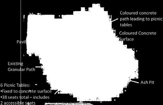
8 1.3 Recommendations Park Capacity Existing Picnic Area To align the picnic seating capacity with the parking capacity of the site, the following is recommended: Varied Picnic Capacity 1) reduce the total number of picnic table seats from 830 to 419 2) delegate implementation of booking rules to the Director of Parks & Recreation To provide varied picnic capacity sites with emphasis on smaller picnic users, the following is recommended. (See Figure 1) 1) provide 14 single picnic tables throughout the site 2) provide the following picnic areas and capacities: a. 1 picnic area with 19 seats b. 4 picnic areas with 38 seats c. 1 picnic area with 50 seats d. 1 picnic area with 100 seats 3

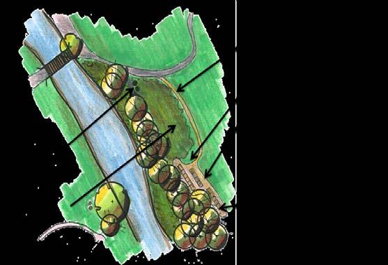
9 Figure 1 Proposed picnic sites 4
 concrete access pathway around tables and concrete surface under tables c) fixed table arrangements to provide accessible ends and")
10 1.3.3 Accessible Picnic Areas In order to provide picnic areas with varying degrees of accessibility, the following is recommended: 1) Provide 4 accessible picnic areas with: a) concrete access pathways, connecting picnic area with parking and washrooms b) concrete access pathway around tables and concrete surface under tables c) fixed table arrangements to provide accessible ends and mid-table, accessible seating d) provide site map showing route to accessible sites See figures 2, Figure 2 Proposed Accessible Picnic Areas 5


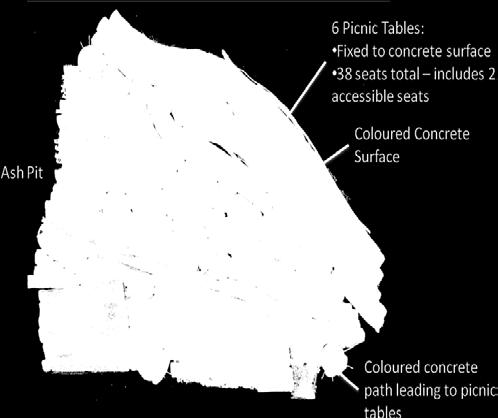
11 Figure 2.1 Picnic Area #1 Figure 2.3 Picnic Area #3 Figure 2.2 Picnic Area #2 Figure 2.4 Picnic Area #4 6

 concrete surface under")

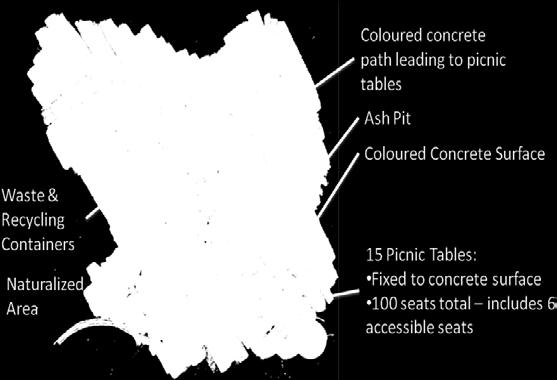
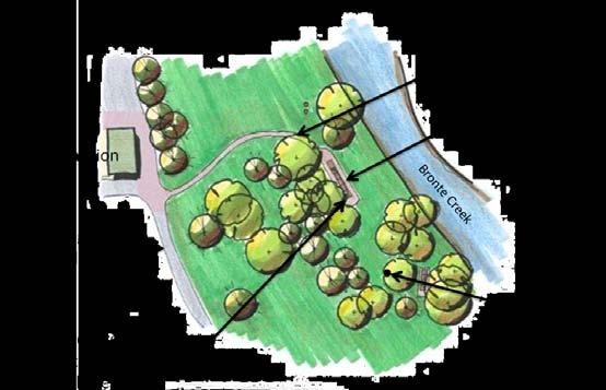
12 2) Provide 3 picnic areas with varying degrees of accessibility, that provides: Figure 3.1 Picnic Area #5 a) fixed picnic tables with accessible ends and mid-table accessible seating b) concrete surface under tables c) site map that identifies surface treatment challenges to accessibility See Figures 3 and 3.1 Figure 3 Proposed picnic areas with varying degrees of accessibility 7


13 1.3.4 Park Character Provide picnic areas that blend in with the natural characteristics of the site by: - using coloured concrete to reduce the glare of concrete finishes - ensure pathways blend in with existing grade of site - use curved forms to shape pathways and seating areas - locating picnic areas to take advantage of the natural feature of the site - restrict vehicle access to the formalized parking area - use natural earth toned colours in concrete and picnic tables - reduce mowing to allow succession planting and naturalization 8


14 2. Trails Wooded Areas and Creeks 2.1 Background Woodchip Trail Lowville Park offers park users a variety of trail options. The trails connect users to the picnic sites; provide access through wooded areas and access over Bronte Creek. The following describes the character and functions of the trail system: - Woodchip Trails Woodchip trails are formal trails in wooded areas and are maintained on a regular basis. Woodchip reduces the compaction resulting from walking. Woodchip use as a trail surface material is considered to be good woodlot stewardship. Woodchip walking trails are considered to be accessible for personal mobility devices. - Mown Grass Trails Mown grass trails are formal trails in naturalized areas. They vary in width and during wet weather cannot be mowed due to ground conditions, Delayed mowing results in trails that are less accessible. Mown Grass Trail - Aggregate Walkways Aggregate walkways are formal trails used to connect the parking lot to various park features. These surfaces are susceptible to weed growth and uneven grade conditions caused by weather and use. - Foot Paths Foot paths are narrow dirt paths formed overtime by informal, occasional use. These trails are often redundant to other formal trails or are non-maintainable due to the physical condition of the site. Foot paths formed along the creek contribute to erosion of the banks. Due to lack of buffer material on the ground there is a potential for root systems to sustain heavy compaction and damage. Aggregate Walkway 9


15 - currently the park is lacking trail information or maps to provide the following: a) location of trail routes b) difficulty in level of use - there are no trail markers to guide users - there is limited interpretive signage - informal footpaths are in close proximity to the formal trails, making them redundant - there is lack of resting areas along trails 2.2 Community Consultation The following is a summary of comments received through the Public Consultation Process: - walking trails along creek and woodlot are amongst the most popular and enjoyed activities in Lowville Park. The trails are often the destination that users come for. - creek and woodlot are extremely valued assets of Lowville Park, Lowville is viewed as a unique park offering natural beauty, peace, and quiet escape. - keep Lowville Park in its natural state, do not over develop - desire to have educational interpretive information displays - concerns with too many signs 10
 provide defined access points to creek along trails so as to divert foot traffic away from areas of creek banks that are")
 discuss with adjoining neighbours the need for heavier fencing Example of a Trail Identification Map 7) provide park boundary signs to discourage access to private property 8)")
16 2.3 Recommendations Encourage Responsible Enjoyment of Natural Areas To encourage responsible enjoyment of creeks and wooded areas, the following is recommended: 1) naturalize and close off foot paths that cause erosion along creek banks and disturbed areas 2) provide defined access points to creek along trails so as to divert foot traffic away from areas of creek banks that are vulnerable to erosion 3) provide opportunities to view environmentally sensitive areas 4) keep trail system as natural as possible 5) consider closing footpaths and trails leading to or adjacent to private property 6) discuss with adjoining neighbours the need for heavier fencing Example of a Trail Identification Map 7) provide park boundary signs to discourage access to private property 8) realign sections of trails to provide greater buffers to sensitive creek banks and wooded areas prone to erosion 9) naturalize grass trails that are redundant 10) provide interpretive signage on natural environment, geographical features, wildlife and fisheries 11
 site map, displayed at an information centre.")
 trailhead markers are to be displayed at beginning points of trails and are to provide the following information: o o o o o length of trail type of surface average and minimum trail width")
17 2.3.2 Provide Trails with Varying Degrees of Accessibility To provide varying degrees of accessibility to trails, the following is recommended: - Trails identification A trails identification system is to be developed comprised of the following key components: a) site map, displayed at an information centre. Map is to identify trail locations, length and levels of difficulty so trail users can select a suitable trail prior to starting. b) trailhead markers are to be displayed at beginning points of trails and are to provide the following information: o o o o o length of trail type of surface average and minimum trail width average and maximum running slope and cross slope location of amenities, where provided c) markers located along trails to identify distance remaining 12
18 - Resting Areas Provide benches at resting areas along the trails at key points of interest - Physical Improvements to Trails Propose improvements to trails including: See Figure 4. a) maintain existing woodchip trails and reconstruct as necessary to ensure they consistently meet standard tread width, clearing width, height and depth of woodchip for ease of accessibility b) install new sections of woodchip trail to make appropriate trail connections and to maintain consistency in accessibility c) convert mown grass trails to woodchip trails where feasible to improve accessibility d) eliminate foot paths that are not maintainable due to terrain or location and naturalize with plant material 13

19 Figure 4 Physical Improvements to Trails 14

 are utilized by picnic patrons - park")
20 3. Park Entry and Parking 3.1 Background Existing Park Entry Parking for Lowville Park is accessed by an entry point off of Guelph Line, commonly known as Lowville Park Road. Parking is provided in one area, located in the front of the park. The parking area currently provides 240 parking spaces, 8 of which are designated accessible. The following describes the current function of the parking lot: - parking is free and provided on a first come, first serve basis - parking lot is generally under-utilized Monday through Friday, during the May to September picnic season and from September to May - majority of parking spaces on Saturday, Sunday and statutory holidays (May-September) are utilized by picnic patrons - park capacity was adjusted for the 2012 picnic season to align with the parking capacity. Further recommendations are provided within the picnic section. Existing Parking Lot - concerns with the efficiency of the layout and difficulty to manoeuvre have been expressed - parking lot is constructed as a continuous tar and chip surface - currently there are no existing planted islands to break up the paved surface and provide shade - park patrons illegally park on internal lanes and surrounding streets. Reduction in picnic capacity and placement of stone barriers around the lot in 2012 helped to reduce this problem. 15

21 3.2 Community Consultation The following is a summary of comments received through the Public Consultation Process: - majority are not willing to give up green space for additional parking Approach to Park Entrance - desire to have an information centre as you arrive to display facility information, such as trails and picnic areas, interpretive information - park lacks sense of entry upon arrival - desire to improve aesthetics of the driveway entry and parking area with planting - reduce the total picnic capacity so that it is compatible with the amount of available parking and washroom facilities - local residents desire to reduce the number of people and cars on summer weekends - discussions on options including paid parking during peak picnic days and encouraging car pooling were discussed 3.3 Recommendations Enhance Sense of Entry To improve sense of entry into the Park, the following enhancements are recommended: 16

 Widen entrance driveway as necessary for ease of circulation and to accommodate the addition of planting island.")
22 1) Information Centre Install an information centre at the park entrance area in proximity to the parking lot. This will be a kiosk style structure that is in keeping with the natural characteristics of the park. The following information will be displayed: Example of Information Centre - map identifying park facilities and trails - interpretive display of natural features - park rules and regulations - picnic locations - community information board 2) Widen entrance driveway as necessary for ease of circulation and to accommodate the addition of planting island. 3) Install planting island at main entrance driveway Refer to figure 5 Proposed Greener Parking Lot Planting Island Greener Parking Lot To reduce the expanse of hard surface and provide a greener parking lot, the following is recommended: - install tree planting islands within parking lot - install wooden bollards to clearly identify limit of parking spaces related to planting islands 17

23 3.3.3 Ease of Circulation and Maximize Parking Space To maximize parking spaces in existing parking area while ensuring ease of circulation, the following is recommended: See Figure 5 Existing Parking Lot - maintain existing parking lot footprint - implement new layout to increase size of parking spaces so as to meet current site-plan standards to improve visibility and ease of traffic flow - total number of proposed parking spaces is 195 (187 spaces and 8 accessible spaces) 18

24 Figure 5 19

25 3.3.4 Encourage Carpooling of Users While the proposed reduction of picnic capacity will reduce the number of cars, car pooling of park patrons will further reduce the number of cars requiring parking. To encourage voluntary carpooling the following is recommended: - picnic permits to include communication on limited parking and the importance of carpooling 20


26 4. Buildings 4.1 School House Existing School House Background The Lowville Park School House was built in 1888 and is a designated Heritage Building It is an important part of the Lowville community heritage. Currently the building functions as follows: - park maintenance building was added in 1947 and functions as a work shop - the building does not contain washroom facilities - building is used for meetings and Boy Scout activities primarily as one day events through the permit process - building is not accessible Existing School House 4.2 Building Condition School House, originally built in 1888, consists of original construction; stone exterior walls, single pane glass and cedar shake roof (roof 1992). This facility is designated as a heritage building. Major renewal requirements over the next 5 7 years are required for building stabilization. Major renewal requirement items include: - electrical, lighting - unit heaters 21

27 - paddle fans - various wood trim - roofing (2015) Existing Attached Maintenance Facility The attached maintenance facility, originally built in 1947(attached to rear of school house) is constructed of a wood clad / wood framed structure sitting on a concrete slab foundation with a wood truss and cedar shake roof. This type of structure is designed to last approximately 50 years. The exact dates are not known, however over the past recent years the maintenance facility has had some major renovations to maintain the facility for its current use. This includes the addition of the concrete slab floor, interior particle board walls, exterior painting, newer soffits, fascia and downspouts. The roof of the maintenance facility was done at the same time as the school house in Minor renewal items over the next 3 10 years include: - lighting - exterior double doors - exterior siding - roofing 22

28 4.3 Community Consultation The following is a summary of the comments received through the Public Consultation process: Existing Maintenance Compound - encourage greater use of the school house such as weddings, meeting venue and rental opportunities - put in washrooms to make it more attractive for renters - renovate so residents can use for local community purposes - don t change character of the building - remove maintenance facilities behind building - increased use of building, for example weddings, will add to parking problems, need to co ordinate with picnics 4.4 Recommendations 1) investigate potential to relocate existing maintenance compound function to another area of the park 2) continue repairs and renewal programs to ensure structural integrity of this heritage building 23

29 4.5 North Washrooms Ball Diamond Club House Background The north washroom building was constructed in The following is a description of the building and its use: - building was originally built as a field house, providing washrooms, change rooms and a concession area for baseball and picnic users Existing North Washrooms Ball Diamond Club House - the change rooms and concession areas have not been used for approximately 15 years - services are provided from an existing septic field - washroom facilities were upgraded approximately 4 years ago - water is provided from a new well drilled in Water is treated and pumped from the main pavilion to this building - building is very well used by picnic and general park users throughout the week, particularly on the weekends during picnic season Master Plan recommends a structured 100 persons picnic area and a 50 persons picnic area (total of 150 persons) in the vicinity of the North Washroom area. 4.6 Building Condition Originally built in 1965, the one story Lowville Park north washroom building is constructed of a concrete block structure with an asphalt shingle roof. This type of structure is designed to last approximately 60 years. The building has approximately 12 years remaining based on age. 24
 to approx. 2033.")
30 Renewal requirements over the next 3-4 years will be required to maintain the anticipated life of this asset. Once completed the asset could extend its life beyond the anticipated life (2020) to approx Interior Washroom Major renewal requirement items include: - new roof within the next 2-6 years - lighting and electrical - restroom fixtures - door assembly - painting 4.7 Community Consultation The following is a summary of the comments received through the Public Consultation Process: - washrooms are needed in this area for large groups and baseball events - find use for unused areas of the building - unused areas could be used for storage - support for eventually building new field house with washrooms only 25
 explore establishing a new well and septic system to provide water 4) investigate the feasibility of using of the concession / change room area for RPM operations. 26")
31 4.8 Recommendations 1) continue to maintain and use the existing washrooms Existing North Washrooms Ball Diamond Club House 2) confirm viability of existing septic system and identify program to ensure continued service 3) explore establishing a new well and septic system to provide water 4) investigate the feasibility of using of the concession / change room area for RPM operations. 26

32 4.9 Buredaca Building Background The Buredaca building was constructed in 1966, providing washroom facilities and a camp storage / program area. The following is a description of the building and its use: Existing Buredaca Building - services are provided by a septic system and well - washrooms have been out of service to the public for approximately 8 years - storage area has not been used for community programs for approximately 10 years since the camp moved operations - storage area was used to store new picnic tables in 2012 as a temporary measure - RPM have indicated they do not require this building for ongoing operational needs - presently there is no identifiable use for the facility other than re-instatement of washroom services to this area if needed Master Plan recommends a structured 38 persons picnic area and 8 single picnic tables (total of 86 persons) in the vicinity of the Buredaca Building Building Condition Originally built in 1966, the Buradaca building is constructed of a wood clad/wood framed and concrete block structure sitting on a concrete foundation with an asphalt shingle roof. This type of structure is designed to last approximately 50 years. The building is reaching the end of its life. 27


33 4.11 Community Consultation The following is a summary of the comments received through the Public Consultation process: - desire to have washrooms for picnic and park users - use of the existing building for storage - building could be used as an interpretive building and / or teaching education centre - rehabilitate the existing storage area and washrooms - restoration work needs interpretive signage - remove portions of building that are unused - structure to be in character with natural setting 4.12 Recommendation In the absence of an identifiable use for the Buredaca building, staff are recommending the following: Temporary Washrooms 1. removal of existing Buredaca Building 2. provide seasonal, temporary washrooms, including one accessible family, one female and one male washroom (similar to City View Park) 3. include the cost of the seasonal washroom facilities in the 2014 current budget process (RPM) Temporary Washroom - Exterior Temporary Washroom Interior 28

34 4.13 Pavilion Background The Lowville Pavilion was originally constructed around the 1950 s. It had contained washrooms, maintenance storage space, a concession and a change room for winter skating. The Pavilion operated as the main building in Lowville Park from the time it was built. Existing Pavilion In 2007, the building had undergone major renovations. The renovations project included the following works: - removal and replacement of most of its interior structure - new men s and women s accessible washrooms - Roads and Parks Maintenance Staff office - interior storage for maintenance equipment - covered shelter area with picnic tables - new septic tank, new ultraviolet water treatment system, new pump and new water softening unit In August of 2011, a new well was installed in proximity to the pavilion and the old well decommissioned in order to meet the high demand of water required for the Pavilion. The new well also serves the North Washrooms building; water is pumped from the well to the North Washrooms. 29

35 4.14 Building Condition The 2007 renovation addressed all of the identified requirements at the time, and extended the useful life of all systems included within the scope of the 2007 project. Existing Pavilion 4.15 Community Consultation The following is a summary of the comments received through the Public Consultation Process: - the pavilion generally functions well - washrooms can be busy during peak picnic days 4.16 Recommendations 1. maintain current uses of building 2. continue repairs and renewal schedule identified for the Lowville Pavilion in order to maintain its ongoing use 3. monitor and provide regular maintenance to building to ensure efficiency and good working condition of the facilities 30


36 5. Winter Activities 5.1 Background Lowville Park has a long history as a destination for winter activities, including hiking, cross country skiing, outdoor skating and tobogganing. Lowville Park also hosts the annual Burlington Winter Games. - currently, outdoor skating is provided with a temporary rink set up and maintained by Roads and Parks Maintenance staff, subject to weather conditions - currently, casual tobogganing occurs on the south portion of the park To enhance safety of tobogganing use, the following measures have been implemented: - hay bales are placed around existing trees in the run area - signs are placed to bring awareness to trail users of the tobogganing use - signs are placed identifying risks and responsibilities of users 5.2 Community Consultation The following is a summary of comments received through the Public Consultation Process: - tobogganing is viewed as a popular activity - skating is a desirable activity 31

 Tobogganing In the event that tobogganing continues to be an acceptable use, the following is recommended: a) continue practices presently in place b) conduct a risk assessment")
37 - both tobogganing and skating are deemed to be enjoyable by residents of the Lowville Area and other City residents who travel to the park to participate in these activities Existing Information Sign - the suggestion to remove the tree at the bottom of the hill, where tobogganing takes place as a way to enhance safety was deemed unacceptable - provide steps to access the hill where tobogganing takes place - consider alternatives such as plastic ice that is not vulnerable to weather conditions 5.3 Recommendations 1) Tobogganing In the event that tobogganing continues to be an acceptable use, the following is recommended: a) continue practices presently in place b) conduct a risk assessment of current and proposed practices and or actions and implement any recommendations Existing Hay Bales 2) Ice Rink Provide support as per the Roads and Park Maintenance Policy for Community Ice Rinks as weather permits. 3) Burlington Winter Games Provide current level of support in organizing and conducting the Burlington Winter games as weather permits 32

38 6. Leash Free Approach 6.1 Background While it was acknowledged that the practice of allowing dogs off leash was prevalent, there were mixed opinions on establishing a leash free area in Lowville Park. Several options were discussed including the following: - Fenced Leash Free Area This option would require fencing an area of 0.33 ha or larger, exclusively for the use of dogs off-leash. Dog owners would be required to have dogs on leash until accessing the fenced area. - Alternative Time Leash Free This option would require establishing a designated area where dogs would be allowed off-leash for designated days, times and months. For example; leash-free would be allowed Monday to Friday, 7 am until dusk from May until September. This would ensure dogs would be on leash during Saturday and Sunday s during the picnic season. Dog owners would be required to have dogs on leash until entering the leash-free zone. 6.2 Community Consultation The following is a summary of comments received through the Public Consultation Process: - support leash-free in the back leash-free time zone - some owners not responsible 33
39 - signs to warn people of the leash-free times and areas - leash-free Monday through Friday, on leash Saturday & Sunday - leash-free during week days but have dogs on leash during busy times, Saturday, Sunday and holidays - leash-free area at the Buredaca section of the park Monday through Friday - keep the dog beach for dogs to swim - no leash-free zones / times - I don t want a leash-free dog area that is fenced in, if need be why not have the whole park leash free before 8:00 am on weekends? It s a wonderful plan for dogs to be dogs, provided owners pick up after them, which they usually do. In my experience, people who bring their dogs here have dogs that are well socialized and well trained / behaved. Let s not ruin that wonderful experience. - no leash-free area dogs can be frightening - contradicts the idea of trail walking by families, especially with small children. Burlington has 3 permanent full time leash-free parks already. Leash-free will deny normal park use to the majority of users - keep dogs on leash. We are not all dog owners and are very concerned about dogs around the children s playground. Also, once off-leash owners are less likely to clean up. - my dog has already been attacked once by a dog that was off-leash 34
 operate a one year pilot project for an alternate time, leash")
40 6.3 Recommendations The privilege to allow dogs off-leash in public space comes with responsibility and owners must adhere to rules and by-laws to ensure the safe enjoyment for all park users. The following are recommendations to consider when planning an alternative leashfree area: Example of Alternative Time Leash Free Sign 1) operate a one year pilot project for an alternate time, leash free in the recommended Buredaca area, refer to figure 1 2) operation of an alternative time leash-free would be consistent with the core principles, site criteria and exclusion areas as outlined in PR 33/12 Leash Free Time Optional Opportunities 3) establish specific time, day and seasons for alternative times leash-free 4) provide means for residents to comment on pilot project 5) authorize the Director of Parks & Recreation and / or Roads and Parks Maintenance and / or By- Law Enforcement the authority to terminate or extend the pilot project 35

41 Figure 1 36


42 7. Access to Creeks 7.1 Background Bronte Creek is a significant natural feature in Lowville Park that passes through both picnic areas and natural areas. The following describes how the creek functions: - currently there are 3 bridges providing access over the creek to various park features - parks users access the creek by walking off the creek banks into the water - parks users fish from the banks as well as from points standing in the creek - the creek is not designated as an area for swimming - water flow and depth vary dependent on daily weather conditions and time of year Existing Warning Sign - signs are in place warning park users that creek water has not been tested, may be polluted and to use at own risk 7.2 Region of Halton Comments The Region of Halton monitors the Region s public beaches, including Beachway Park, to protect swimmers form illnesses or harm that may be linked to unsafe water quality. Samples are collected that are representative of the majority of the bathing area and tested for bacteria during the bathing season. A beach is considered unsafe for swimming when water sample results indicate the average level of E. coli is higher than the provincial guideline. 37


43 The Region of Halton does not monitor the water at Bronte Creek in Lowville. Bronte Creek is not a public beach. The creek is rather shallow and the water is fast flowing, therefore any sample results would not necessarily be representative of the creeks water quality. Existing Bridge Over Creek Swimming is not recommended at Bronte Creek in Lowville. If parents permit their children to have access to the creek it is important that they monitor their children and ensure their children do not drink the water and they wash their hands after playing in the water, especially before eating. 7.3 Public Consultation - provide splash pad to minimize water activities in creek that are damaging the ecosystem - access to creek is vital but could be limited to certain spots - address the issue of pollution, risk and signage of creek water - buffers should be increased at rivers edge to stabilize banks and improve water quality - continue to allow dogs access to creek 7.4 Recommendations City of Burlington staff and the Region of Halton acknowledge that Bronte Creek, which runs through Lowville Park, is not a designated swimming area. This area is not subject to the Region of Halton water testing process. As such the following recommendations are proposed: 38
 creek conditions could change quickly.")
44 1) develop signage program that informs park users of risks associated with entering the creek that may include the following: a) these waters are not supervised, use at your own risk b) these waters may be contaminated and are not tested by the Region of Halton c) creek conditions could change quickly. Park users entering the creek should be aware of increased current, water depth and potential of floating objects. d) The City of Burlington is not responsible for any injuries, death, damages or loss of property for any reason including negligence 2) park users entering the creek are prohibited from making physical changes to creek, i.e. moving or removing rocks 3) park users entering the creek are prohibited from disturbing creek wildlife 4) fishing is governed by the Province of Ontario regulations 5) increase awareness of risks associated with creek access through information provided to the permit holder at the time they pick up their permit 39

45 LEGEND ACCESSIBLE PICNIC AREA - PROPOSED GUELPH LINE PICNIC AREA - VARYING DEGREES OF ACCESSIBILITY - PROPOSED SINGLE PICNIC TABLE - PROPOSED SCHOOL HOUSE 38 PARKING LOT BRONTE CREEK * 38 PLAY- GROUND PAVILION BASEBALL CLUBHOUSE 100 SHELTER 50 BASEBALL DIAMOND REMOVE BACKSTOP CAMP BUREDACA BUILDING BRONTE CREEK SHELTER 38 * NATURALIZED AREA - PROPOSED PARK INFORMATION KIOSK - PROPOSED PAVED PATH - PROPOSED WOOD CHIP PATH - PROPOSED MOWN PATH TO REMAIN WOODCHIP PATH TO REMAIN WOODCHIP PATH - CONVERTED FROM MOWN/WOODCHIP PATHS CLOSE AND NATURALIZE PATH PAVED PATH TO REMAIN GRANULAR PATH TO REMAIN PEDESTRIAN BRIDGE REMOVE SHED INSTALL SIGN TO DESIGNATE END OF PATH meters Community Services Division - Parks and Recreation Department
46 Cost Estimate and Phasing Strategy Lowville Park Master Plan 2013 DATE: March 5, 2013 PHASE PICNIC AREAS CONSTRUCTION Construction of the Picnic Areas will align park capacity with parking capacity. ACCESSIBLE PICNIC AREAS #1, 3, 4 $ 219, work includes picnic tables installation, construction of surface under tables & connecting pathways PICNIC AREA #5 - varying degree of accessibility $ 25, work includes picnic tables installation and surface under tables PICNIC AREA #6, 7 - varying degree of accessibility $ 40, installation of picnic tables under existing shelters SINGLE PICNIC TABLES $ 19, installation of single picnic tables in various locations HST Charged %) $ 5, Contingency (10%) $ 30, Picnic Areas Construction Total $ 341, INFRASTRUCTURE REMOVALS Remove old backstop, baseball lights and concrete storage shed. INFRASTRUCTURE REMOVALS $ 23, HST Charged %) $ Contingency (10%) $ 2, Infrastructure Removals Total $ 25, Topo Survey, Arborist, Contrete Testing $ 25, Staff Chargebacks $ 26, Tendering Costs (Advertising, Printing, Permit Etc.) $ 2, PHASE 1 PROJECT GRAND TOTAL $ 420,656.19
47 Cost Estimate and Phasing Strategy Lowville Park Master Plan 2013 DATE: March 5, 2013 PHASE 2 TRAILS and NATURALIZATION Construction of new woodchip trail connections and naturalization of foot trails, mowed areas and existing redundant trails. Construction of bench resting areas along trails. NATURALIZATION AREAS $ 9, TRAIL NATURALIZATION $ 9, WOODCHIP TRAIL CONSTRUCTION $ 9, TRAILS - RESTING AREAS $ 56, HST Charged %) $ 1, Contingency (10%) $ 8, Trails / Naturalization Total $ 95, SIGNAGE and INFORMATION CENTRE Construction of Information centre at park entrance area to identify park facilities, trails, park rules and regulations. Construction of Picnic Area signage and Trails signage INFORMATION CENTRE $ 65, PICNIC SIGNAGE $ 14, TRAILS SIGNAGE $ 22, HST Charged %) $ 1, Contingency (10%) $ 10, Signage / Information Centre Total $ 114, Topo Survey, Arborist, Contrete Testing $ 13, Staff Chargebacks $ 20, Tendering Costs (Advertising, Printing, Permit Etc.) $ 2, PHASE 2 PROJECT GRAND TOTAL $ 245,255.64
48 Cost Estimate and Phasing Strategy Lowville Park Master Plan 2013 DATE: March 5, 2013 PHASE 3 PARK ENTRY and PARKING LOT Construction of tree planting islands at main entrance driveway and in parking lot. PARKING MAIN DRIVEWAY ENTRY ENHANCEMENTS $ 20, PARKING LOT ENHANCEMENTS $ 75, HST Charged %) $ 1, Contingency (10%) $ 9, Park Entry and Parking Lot Total $ 107, Topo Survey, Arborist, Contrete Testing $ 5, Staff Chargebacks $ 10, Tendering Costs (Advertising, Printing, Permit Etc.) $ 2, PHASE 3 PROJECT GRAND TOTAL $ 124,633.14
49 Cost Estimate and Phasing Strategy Lowville Park Master Plan 2013 DATE: March 5, 2013 PHASING - As per Building Asset Category (Repair & Renewal Plan) BUILDINGS Buredaca Building Demolish Buredaca Building and rent temporary washrooms for 5 months/year during picnic season (cost includes 1 st year of rental only) BUREDACA BUILDING $ 66, School House Renovations required for School House and attached maintenance facility to extend life for up to 30 years SCHOOL HOUSE $ 100, North Washrooms Ball Diamond Clubhouse Renovations required to extend life for another 20 years NORTH WASHROOMS - BALL DIAMOND CLUBHOUSE $ 60, HST Charged %) $ 3, Contingency (10%) $ 22, Buildings Grand Total $ 253, Topo Survey, Arborist, Contrete Testing $ 1, Staff Chargebacks $ 6, Tendering Costs (Advertising, Printing, Permit Etc.) $ 2, PHASING OF BUILDINGS PROJECT GRAND TOTAL $ 263, HST Charged %) $ 14, Contingency (10%) $ 83, Grand Total $ 1,054,094.87
China Creek North Park Upgrades and Glen Pump Station. Park Board Committee Meeting Monday, July 10, 2017
 China Creek North Park Upgrades and Glen Pump Station Park Board Committee Meeting Monday, July 10, 2017 Purpose The purpose of this presentation is to: Share the results of the public engagement processes;
Welcome to the future of Terwillegar Park a Unique Natural Park
 Welcome to the future of Terwillegar Park a Unique Natural Park 1 Introduction The Terwillegar Park Concept Plan study will develop an overall concept plan, management objectives and development guidelines
Logo Department Name Agency Organization Organization Address Information 5700 North Sabino Canyon Road
 Logo Department Name Agency Organization Organization Address Information United States Forest Coronado National Forest 5700 North Sabino Canyon Road Department of Service Santa Catalina Ranger District
Committee. Presentation Outline
 CW-33-15 11/9/2015 Community and Corporate Services Committee November 10, 2015 1 Presentation Outline Background Vision and Objectives Study Process and Timeline Public and Stakeholder Engagement Organization
Blue River Trail Master Plan JSA to Town Hall June 2004
 Blue River Trail Master Plan JSA to Town Hall June 2004 Prepared for: Silverthorne Town Council Silverthorne SPORT Committee Department of Recreation and Culture Silverthorne Public Works Silverthorne
Cedars RV Resort Owners Handbook. Phases 1,2,3
 Cedars RV Resort Owners Handbook Phases 1,2,3 NOTICE TO READER This document can and will evolve over time. Every effort has been made to provide simple clarity to common topics requiring definition. Should
2015 Bond Proposal Model Airplane Parks (PR96) Alternative Model Airplane Park Location
 Alternative Model Airplane Park Location") Our club, Green Valley R/C Flyers, is presenting this proposal for consideration as an alternative location for a Model Airplane Park to be included in PR96 for the 2015 Bond Election. We are recommending
Our club, Green Valley R/C Flyers, is presenting this proposal for consideration as an alternative location for a Model Airplane Park to be included in PR96 for the 2015 Bond Election. We are recommending
TRUCKEE TAHOE AIRPORT DISTRICT BOARD OF DIRECTOR STAFF REPORT
 AGENDA ITEM: 11 TRUCKEE TAHOE AIRPORT DISTRICT BOARD OF DIRECTOR STAFF REPORT AGENDA TITLE: MEETING DATE: January 24, 2018 PREPARED BY: NTPUD Agency Partnership Opportunity, Multi-Use Trailhead Access
M E S T I Z O C U R T I S P A R K
 ARAPAHOE CONNECTION TO BUS ROUTE AT ND AND LAWRENCE, FUTURE LIGHT RAIL STATION LEGEND SOCIAL TRAIL FLAGSTONE PAVING TO RESTORE/MAINTAIN CONCRETE PAVING DIAGONAL CURVILINEAR SOCIAL ROUTE IS OUT OF HISTORIC
MORGAN CREEK GREENWAY Final Report APPENDICES
 APPENDICES MORGAN CREEK GREENWAY Appendix A Photos of Existing Conditions in Trail Corridor Photos of existing conditions Main trail corridor - February 2009 Photos of existing conditions south bank Morgan
NORTHWEST SECTION CONTENTS: CLEVELAND PARK FOLWELL PARK RYAN LAKE PARK VICTORY PRAIRIE DOG PARK VICTORY PARK
 NORTHWEST SECTION CONTENTS: CLEVELAND PARK FOLWELL PARK RYAN LAKE PARK VICTORY PRAIRIE DOG PARK VICTORY PARK LUCY LANEY COMMUNITY SCHOOL N 33RD AVE N 33RD AVE SINGLE-FAMILY RESIDENTIAL MULTI-USE DIAMOND
DRAFT. Dorabelle Campground Rehabilitation
 DRAFT Dorabelle Campground Rehabilitation September 2012 1.1 REGIONAL SETTING AND PROJECT LOCATION The Dorabelle Campground is located on the western shore of Shaver Lake in Fresno County, California (Section
35 Bee Tree Park Planning Zone 3
 35 Bee Tree Park Planning Zone 3 2701 Finestown Road Visit Date: August 2016 St. Louis County Parks Master Plan Page 1 35 Bee Tree Park 2701 Finestown Road St. Louis County Parks Master Plan Planning Zone
City of Durango 5.8 FUNDING TRAILS DEVELOPMENT
 5.8 FUNDING TRAILS DEVELOPMENT The City has been successful in establishing dedicated local funding sources as well as applying for grants to develop the City s trail system, having received nearly $2.4
Bloor Street West Rezoning Application for a Temporary Use By-law Final Report
 STAFF REPORT ACTION REQUIRED 3741 3751 Bloor Street West Rezoning Application for a Temporary Use By-law Final Report Date: June 12, 2007 To: From: Wards: Reference Number: Etobicoke York Community Council
Preferred Recreation Recommendations Stemilt-Squilchuck Recreation Plan March 2018
 Preferred Recreation Recommendations Stemilt-Squilchuck Recreation Plan March 2018 Below are the recommended recreation ideas and strategies that package together the various recreation concepts compiled
Watchorn Provincial Park. Management Plan
 Watchorn Provincial Park Management Plan 2 Watchorn Provincial Park Table of Contents 1. Introduction... 3 2. Park History... 3 3. Park Attributes... 3 3.1 Natural... 4 3.2 Recreational... 4 3.3 Additional
Recreation Management Plan Lake Baroon and Ewen Maddock Dam
 Lake Baroon and Ewen Maddock Dam December 2013 Contents Overview... 3 The Value of Our Natural Areas... 4 Management Approach... 6 Funding... 7 Recreation Management... 8 Conditions of Access and Use...
5.0 OUTDOOR RECREATION OPPORTUNITIES AND MANAGEMENT
 5.0 OUTDOOR RECREATION OPPORTUNITIES AND MANAGEMENT 5.1 Introduction This section describes the range of recreational activities that currently take place in Marble Range and Edge Hills Parks, as well
Proposal to Redevelop Lower Kananaskis River-Barrier Lake. Bow Valley Provincial Park. Frequently Asked Questions
 Proposal to Redevelop Lower Kananaskis River-Barrier Lake Bow Valley Provincial Park Frequently Asked Questions What is being proposed? What are the details of the proposal? Where is the project area located?
RIVER ACCESS STRATEGY
 RIVER ACCESS STRATEGY The River Access Strategy is a 10-year plan the City of Edmonton is developing to inform future programming, operations and infrastructure improvements that support access to the
Appendix 3. Greenway Design Standards. The Whitemarsh Township Greenway Plan
 Appendix 3 Greenway Design Standards This chapter discusses two design standards for the greenway types discussed above. First, trail design standards are presented together with trailhead facilities and
BACKCOUNTRY TRAIL FLOOD REHABILITATION PROGRAM
 BACKCOUNTRY TRAIL FLOOD REHABILITATION PROGRAM Backcountry Trail Flood Rehabilitation A June 2013 Flood Recovery Program Summary In June 2013, parts of Southern Alberta were devastated from significant
Mt. Hood National Forest
 United States Department of Agriculture Forest Service Mt. Hood National Forest Zigzag Ranger District 70220 E. Highway 26 Zigzag, OR 97049 503-622-3191 Fax: 503-622-5622 File Code: 1950-1 Date: June 29,
Seek the Board s approval for the Donald Place kerb and channel renewal to progress to final design, tender and construction; and
 3. DONALD PLACE - KERB AND CHANNEL RENEWAL General Manager responsible: General Manager City Environment Officer responsible: Transport and City Streets Manager Author: Michelle Flanagan, Streets Capital
POLICY DCS-04: Tourism Directional Sign Policy. Development and Cultural Services
 DCS-04 Page 1 of 8 POLICY DCS-04: Tourism Directional Sign Policy Development and Cultural Services Approval Date: March 11, 2008 Approval Authority: Council, Resolution No. 7 Effective Date: March 11,
Winnipeg Beach Provincial Park. Draft Management Plan
 Winnipeg Beach Provincial Park Draft Management Plan 2 Winnipeg Beach Provincial Park Table of Contents 1. Introduction... 3 2. Park History... 3 3. Park Attributes... 4 3.1 Natural...4 3.2 Recreational...4
Cooloolabin Dam Recreation Management Discussion Paper. November 2013
 Cooloolabin Dam Recreation Management Discussion Paper November 2013 Contents November 2013... 1 Background... 3 Overview of Cooloolabin Dam... 6 Weed Management... 7 Cultural Heritage... 7 Commercial
Non-motorized Trail Plan & Proposal. August 8, 2014
 Town of Star Valley Ranch, Wyoming and the Star Valley Ranch Association in partnership with the USDA Forest Service, Bridger-Teton National Forest, Greys River Ranger District Non-motorized Trail Plan
METROPOLITAN COUNCIL 390 North Robert Street, St. Paul, MN Phone (651) TDD (651)
 TDD (651)") METROPOLITAN COUNCIL 390 North Robert Street, St. Paul, MN 55101 Phone (651) 602 1000 TDD (651) 291 0904 DATE: June 19, 2007 TO: Metropolitan Parks and Open Space Commission FROM: Jan Youngquist, Senior
METROPOLITAN COUNCIL 390 North Robert Street, St. Paul, MN 55101 Phone (651) 602 1000 TDD (651) 291 0904 DATE: June 19, 2007 TO: Metropolitan Parks and Open Space Commission FROM: Jan Youngquist, Senior
Chorley Park Trail Connection New Design Options. Information Booklet Prepared for June 9, 2014 Public Meeting
 Chorley Park Trail Connection New Design Options Information Booklet Prepared for June 9, 2014 Public Meeting Chorley Park Trail Booklet June 9, 2014 Page 1 of 12 Our Goals for the Chorley Park Trail Connection
7. Plan Implementation
 7. Plan Implementation 7.1 Implementation Timeline This section includes a list of achievable park and recreation actions. In the Implementation Action Matrix that follows, the implementation actions have
Section 61 Recreational Vehicle Park / Campground (Bylaw No. 2012/10)
") Part 7 General Regulations Section 61 Recreational Vehicle Park / Campground (Bylaw No. 2012/10) 61.1 A comprehensive site plan shall be provided to the satisfaction of the Development Authority that shows
Part 7 General Regulations Section 61 Recreational Vehicle Park / Campground (Bylaw No. 2012/10) 61.1 A comprehensive site plan shall be provided to the satisfaction of the Development Authority that shows
X Respond to staff direction
 Page 1 of Report TO: Community Services Committee Corporate Services Division SUBJECT: Apeldoorn Mundalization Project Report Number: Report Date: February 17, 2010 File Number(s): Ward(s) Affected: 1
Building Permit Application
 Building Permit Application Co-Owner Name Lot # Address City State Zip Phone (home) (cell) Contractor (if applicable) The above named co-owner hereby makes application to Cedar Shores Campground Condominium
Flow Stand Up Paddle Board Parkway Plan Analysis
 Regional Parks Department Jeffrey R. Leatherman, Director County of Sacramento Divisions Administration Golf Leisure Services Maintenance Rangers Therapeutic Recreation Services Flow Stand Up Paddle Board
3. COLTA / HUGA CONNECTIONS - PRELIMINARY
 9 3. COLTA / HUGA CONNECTIONS - PRELIMINARY 3.1 COLTA The Chain of Lakes Trail Association (COLTA) trail, formerly identified as the Chester Spur Line, was completed and opened for use in June 2011. The
The Baker/Carver Regional Trail is intended to
 Section V Design Guidance The Baker/Carver Regional Trail is intended to safely accommodate 183,000 annual visits, an array of non-motorized uses, a variety of skill levels, and persons with special needs.
Wilds. Headwaters. Lakes. Oxbows. Falls
 56 5 4 3 Wilds Headwaters Lakes Oxbows Falls 57 Zones It could be said the on-the-ground essence of this master plan appears within the next 6 pages of this report. As we learned in the preceding Cultural
Bibbulmun Track. Cape to Cape Track. Two of the world s great long distance walking tracks. 973 km. 135 km km Off-road cycle touring
 Trail revitalising Western Australia Bibbulmun Track 973 km Cape to Cape Track 135 km Two of the world s great long distance walking tracks 1062 km Off-road cycle touring Trail revitalising 1. Framework
Stephanie Sinnott, Executive Director, Finance, Office of the City Manager
 Public Report To: From: Finance Committee Stephanie Sinnott, Executive Director, Finance, Office of the City Manager Paul D. Ralph, BES, RPP, MCIP, Commissioner, Development Services Department Report
PORT OF SEATTLE MEMORANDUM. COMMISSION AGENDA Item No. 6a ACTION ITEM Date of Meeting August 23, 2016
 PORT OF SEATTLE MEMORANDUM COMMISSION AGENDA Item No. 6a ACTION ITEM Date of Meeting August 23, 2016 DATE: TO: FROM: Michael Ehl, Director, Airport Operations Wayne Grotheer, Director, Aviation Project
Aspen Skiing Company Policy for Use of Other Power-Driven Mobility Devices And Service Animals
 Aspen Skiing Company Policy for Use of Other Power-Driven Mobility Devices And Service Animals Introduction New rules under the Americans with Disabilities Act (ADA), Titles II and III, went into effect
NEWBORO AND PORTLAND HARBOUR REDVELOPMENT PLANS
 INTRODUCTION The Municipal docks in both Newboro and Portland were transferred to the Township of Rideau Lakes by Parks Canada in 2002. Little has been done to improve the docks physical condition or role
MASTER PLAN EXECUTIVE SUMMARY
 Biscuit Run State Park Scottsville Road (State Route 20) Charlottesville, VA 22902 Biscuit Run State Park MASTER PLAN EXECUTIVE SUMMARY Department of Conservation and Recreation Division of Planning and
Lake Myra County Park. Wake County, North Carolina Community Forum #2 June 12, 2008
 Lake Myra County Park Wake County, North Carolina Community Forum #2 June 12, 2008 Welcome and Introduction Meeting Agenda Welcome Introductions of Project Team Master Plan Process Community Forum #1 Updates
St. John s Park Redevelopment Master Plan Public Engagement Report
 St. John s Park Redevelopment Master Plan Public Engagement Report Prepared by HTFC Planning & Design October 2017 TABLE OF CONTENTS 1.0 Introduction........ 1 2.0 Stakeholder and Public Notification......
LYNDHURST NEW URBAN DEVELOPMENT AREA STRUCTURE PLAN. Lyndhurst New Urban Development Area Structure Plan OUTCOMES AND PERFORMANCE STANDARDS
 APPENDIX 15.1-3 LYNDHURST NEW URBAN DEVELOPMENT AREA STRUCTURE PLAN Purpose of the Structure Plan Lyndhurst New Urban Development Area Structure Plan OUTCOMES AND PERFORMANCE STANDARDS LSP-P1 The District
THAT the Board approve the final proposed concept plan for the Jericho Marginal Wharf site as shown in Figure C-4 of Appendix C.
 Date: January 17, 2012 TO: Board Members Vancouver Park Board FROM: General Manager Parks and Recreation SUBJECT: Jericho Marginal Wharf Phase 2 Concept Plan RECOMMENDATION THAT the Board approve the final
BOAT DOCKS AND LAUNCHES. Public Engagement Report July 2015
 BOAT DOCKS AND LAUNCHES Public Engagement Report July 2015 TABLE OF CONTENTS BACKGROUND 3 STAKEHOLDER CONSULTATION 6 PARTICIPANT PROFILE 7 RESPONSE THEMES 8 CONCLUSION 16 BACKGROUND The North Saskatchewan
ANNE ARUNDEL COUNTY TRAILS
 ANNE ARUNDEL COUNTY TRAILS SPECIAL EVENT AND CHARITABLE FUND-RAISING GUIDELINES Purpose: To standardize the application process for using the Anne Arundel County Trails for events and charitable fund-raising
17 Mathilda Welmering Park Planning Zone 3
 17 Mathilda Welmering Park Planning Zone 3 8301 Mathilda Visit Date: September 2016 St. Louis County Parks Master Plan Page 1 Description: The six acre Mathilda Welmering Park is named for two streets
Trail # NW Tuesday, June DESIGN. Provide an Review the Provide an. Project Goals: System system. wayfinding
 I. Welcome / Introductions Bethany Creek Trail #2 Segment 3 Neighborhood Meeting #1 Bethany Presbyterian Church 15505 NW Springville Road, Portland, OR 97229 Tuesday, June 26, 2018 @ 6:00PM Meeting Minutes
Those with Interest in the City of Cambridge Trail System
 Community Services Department City Hall 50 Dickson Street, P.O. Box 669 Cambridge ON N1R 5W8 Tel: 519-740-4681 July 20, 2010 To: Re: Those with Interest in the City of Cambridge Trail System City of Cambridge
Rating: 5.0 (scale of 1-10)
") 95 Community Trail System Groundcover: 2-metre paved path, 1- metre grass buffer on either side. Location: Fort St. John Ownership: City of Fort St. John Rating: 5.0 (scale of 1-10) Strategic value: Linear
95 Community Trail System Groundcover: 2-metre paved path, 1- metre grass buffer on either side. Location: Fort St. John Ownership: City of Fort St. John Rating: 5.0 (scale of 1-10) Strategic value: Linear
Proposal to Redevelop Lower Kananaskis River-Barrier Lake. Bow Valley Provincial Park
 Frequently Asked Questions Proposal to Redevelop Lower Kananaskis River-Barrier Lake Bow Valley Provincial Park Frequently Asked Questions What has been decided? What are the details of the plan? What
Pier Enhancements April 6, 2017
 Pier Enhancements April 6, 2017 Pier Enhancement Categories Pier Plaza Improvements Contingency Play Elements Destination Differentiators Water Recreation Zone Furniture, Fixtures & Equipment Transportation
Dunsmuir Community Park
 Dunsmuir Community Park Master Plan September 2016 ENGAGEMENT SUMMARY #2 Introduction Public engagement is integral to the development of the Dunsmuir Community Park Master Plan. Two park open houses were
Welcome KROSNO CREEK DIVERSION PROJECT CLASS ENVIRONMENTAL ASSESSMENT
 Welcome KROSNO CREEK DIVERSION PROJECT PUBLIC INFORMATION CENTRE # 1 Tonight s Presentation Study Overview Background Existing Conditions Alternative Solutions Preliminary Preferred Solution Next Steps
2. Goals and Policies. The following are the adopted Parks and Trails Goals for Stillwater Township:
 D. PARKS AND TRAILS 1. Introduction Stillwater Township s population is relatively low, with most residents living on rural residences on large lots. The need for active park space has been minimal in
ETOBICOKE CREEK NORTH TRAIL PROJECT. May 18, 2017 at Michael Power High School 105 Eringate Drive, Etobicoke ON M9C 3Z7
 ETOBICOKE CREEK NORTH TRAIL PROJECT May 18, 2017 at Michael Power High School 105 Eringate Drive, Etobicoke ON M9C 3Z7 1 Purpose of Open House The purpose of today s open house is to present the design
MPRB: Southwest LRT Community Advisory Committee Issues and Outcomes by Location Current to: 12 November 2010
 MPRB: Southwest LRT Community Advisory Committee Issues and Outcomes by Location Current to: 12 November 2010 This is a compilation of issues and outcomes identified by the CAC. It is a work in progress,
Attendance Presentation
 TO The Community of Saanich FROM District of Saanich DATE January 30, 2017 RE Meeting Notes Haro Woods Jan 28th Community Engagement Goward House, 2495 Arbutus Road, Victoria BC Attendance In total, 18
Group similar facilities together separate dissimilar facilities.
 Park design Principle #1 Group similar facilities together separate dissimilar facilities. Why do we do this? Safety Differences in admission fees Differences in seasonal use Reduce user conflicts Principle
Understanding user expectations And planning for long term sustainability 1
 Understanding user expectations And planning for long term sustainability 1 What is a natural surface trail? It can be as simple has a mineral soil, mulched or graveled pathway, or as developed as elevated
Webber Park Master Plan Charrette Summary
 SMALL GROUP #1 - September 29, 2011 Webber Park Master Plan Charrette Summary More trash cans, especially near picnic grounds A year round pool is very needed-physical & mental health are significantly
PIONEER PARK. City of Des Peres Parks Master Plan. SWT Design 46 INTRODUCTION
 PIONEER PARK INTRODUCTION Pioneer Park is a 7 acre neighborhood park located east of Interstate 270 and south of Manchester Road along Tallie Road. The park is situated in a residential neighborhood with
NOTICE OF OPPORTUNITY FOR PUBLIC COMMENT RELATED TO PROPOSED PASSENGER FACILITY CHARGE APPLICATION NOVEMBER 9 TH, 2018
 NOTICE OF OPPORTUNITY FOR PUBLIC COMMENT RELATED TO PROPOSED PASSENGER FACILITY CHARGE APPLICATION NOVEMBER 9 TH, 2018 LAWTON-FORT SILL REGIONAL AIRPORT LAWTON, OKLAHOMA PASSENGER FACILITY CHARGE PROPOSED
City of Fremantle. Joel Levin, Aha! Consulting INTRODUCTION 2 BACKGROUND 3
 -- WORKSHOP REPORT -- Project: Client: Event: South Beach Basketball Court City of Fremantle Community Consultation Forum Date: 12 th November 2015 6:00pm 8:00pm Author: Joel Levin, Aha! Consulting Contents:
Chapter 6: POLICY AND PROCEDURE RECOMMENDATIONS
 Chapter 6 POLICY AND PROCEDURE RECOMMENDATIONS FOR SRRA Below are seven policy elements that should be considered for adoption by the Southwest Regional Recreation Authority of Virginia: 1. Develop strategies
Capital Prioritization
 14 Capital Prioritization 279 279 280 Park & Recreation CAPITAL PRIORITIZATION As described in Chapter 8, the recommendations presented in Chapter 9 are prioritized to provide a guide for future capital
Calgary River Access Strategy Priority Sites and Proposed Funding
 Calgary River Access Strategy Priority Sites and Proposed Funding CPS2017-0103 ATTACHMENT 2 A total of $7,660,000 (Class 5 estimate) is required to implement all sites within the Calgary River Access Strategy;
ANAGEMENT. LAN November, 1996
 M ANAGEMENT P LAN November, 1996 for Paul Lake Provincial Park Ministry of Environment, Lands and Parks BC Parks Department Paul Lake Provincial Park M ANAGEMENT P LAN Prepared by BC Parks Kamloops Area
CLEVELAND PARK LOCATION AND HISTORY EXISTING CONDITIONS AND CHARACTER LOCATION
 CLEVELAND PARK LOCATION LOCATION AND HISTORY Attempts to create a neighborhood park and playground in the Cleveland neighborhood began in 1926, when the park board designated for acquisition the block
MEDIUM SIZE STADIUM STRATEGY
 MEDIUM SIZE STADIUM STRATEGY Approved by City Council on March 12, 2014 This plan is available online at www.edmonton.ca I. Executive Summary... 4 II. Medium Size Stadium Strategy... 5 1. Background...
POLICY & STRATEGIES The Vancouver Park Board approves major changes in Vancouver parks, including the design and development of parks.
 September 8, 2017 TO: Park Board Chair and Commissioners FROM: General Manager Vancouver Board of Parks and Recreation SUBJECT: Brewers Park and Clinton Park Renewal Concept Plans RECOMMENDATION THAT the
9 CONSTRUCTION OF BATHURST STREET FROM GREEN LANE WEST TO SOUTH OF HIGHWAY 11, TOWN OF EAST GWILLIMBURY AND TOWNSHIP OF KING
 Clause No. 9 in Report No. 9 of Committee of the Whole was adopted, without amendment, by the Council of The Regional Municipality of York at its meeting held on May 15, 2014. 9 CONSTRUCTION OF BATHURST
Lake Wissota Access Locations within the LaFayette Township. By Chad Martin
 Lake Wissota Access Locations within the LaFayette Township By Chad Martin Anson/ Wissota Access Point # 1 Road: 195 th St. Associated Fire Numbers: 13294 Defining Characteristics: Forested from road
Waterfront Concept Plan: Community Survey Summary
 Waterfront Concept Plan: Community Survey Summary Published April 20, 2016 #1100085 Introduction The survey was one component of the public consultation process endorsed by Council in October, 2015. This
URBAN DESIGN REPORT. Proposed Residential Development, Old Church Road, Caledon East
 Proposed Residential Development, Old Church Road, Caledon East TABLE CONTENTS: 1.0 DEVELOPMENT 1.1 Introduction-Analysis of Guiding Principles and Documents 1.2 Community Design and Architectural Design
Fossil Creek Wild & Scenic River Comprehensive River Management Plan Forest Service Proposed Action - details March 28, 2011
 Fossil Creek Wild & Scenic River Comprehensive River Management Plan Forest Service Proposed Action - details March 28, 2011 Primary Goals of the Proposed Action 1. Maintain or enhance ORVs primarily by
Design Considerations For Accessible Parks & Trails
 Design Considerations For Accessible Parks & Trails Measuring Up: Campbell River 2008 Dave Calver Consulting City of Campbell River Legacies Now: Measuring Up Design Guidelines Design Considerations for
AGENDA LANARK COUNTY MUNICIPAL TRAILS CORPORATION BOARD OF DIRECTORS
 AGENDA LANARK COUNTY MUNICIPAL TRAILS CORPORATION BOARD OF DIRECTORS Monday, September 17, 2012 8:30 a.m. to 10:00 a.m. Lanark County Administration Building Drummond/North Elmsley Boardroom Page President,
Commissioning Director - Environment
 Finchley and Golders Green Area Committee 27 April 2017 Title Report of Wards Status Urgent Key Enclosures Summers Lane,N12 Request for Pedestrian Improvements Commissioning Director - Environment Woodhouse
Understanding the caring capacity of the visitor experience Provide facilities to support a high level user experience Address visual quality through
 Understanding the caring capacity of the visitor experience Provide facilities to support a high level user experience Address visual quality through recreation ecological restoration opportunities Collaboration
ALL CITY PARKS AND TRAILS ARE SMOKE FREE AS OF APRIL
 Requests must be submitted at least two weeks prior to event. Fayetteville Parks and Recreation Event Form Phone: (479) 444-3471 Fax: (479) 521-7714 Web: www.fayetteville-ar.gov/parks E-mail: parks@fayetteville-ar.gov
THRESHOLD GUIDELINES FOR AVALANCHE SAFETY MEASURES
 BRITISH COLUMBIA MINISTRY OF TRANSPORTATION & INFRASTRUCTURE AVALANCHE & WEATHER PROGRAMS THRESHOLD GUIDELINES FOR AVALANCHE SAFETY MEASURES British Columbia Ministry of Transportation & Infrastructure
Permeable RECREATIONAL TRAILS
 SMART EARTH SOLUTIONS Permeable RECREATIONAL TRAILS GEOWEB GEOPAVE GEOTERRA Innovative Solutions for Designing & Building Trails. Trail Surface Stabilization The key to planning and building trails into
To obtain Board approval to demolish the former St. Ann School Education Resource Centre building located at 2123 Hixon Street, Oakville.
 Regular Board Meeting Tuesday, November 3, 2015 ACTION REPORT ITEM 8.3 FORMER ST. ANN EDUCATION RESOURCE CENTRE BUILDING DEMOLITION PURPOSE: To obtain Board approval to demolish the former St. Ann School
Date: 11 th January, From: Plaistow & Ifold Parish Neighbourhood Plan - Steering Group. Plaistow & Ifold Parish Council
 Date: 11 th January, 2017 From: Plaistow & Ifold Parish Neighbourhood Plan - Steering Group To: Plaistow & Ifold Parish Council Re: Neighbourhood Plan Report to Parish Council Meeting 17 Jan 2017 The Steering
PROPOSED ACTION South 3000 East Salt Lake City, UT United States Department of Agriculture
 United States Department of Agriculture Forest Service Uinta-Wasatch-Cache National Forest Salt Lake Ranger District 6944 South 3000 East Salt Lake City, UT 84121 801-733-2660 File Code: 1950/2300 Date:
DRAFT FINAL ACCESSIBILITY GUIDELINES FOR OUTDOOR DEVELOPED AREAS
 Date: October 19, 2009 DRAFT FINAL ACCESSIBILITY GUIDELINES FOR OUTDOOR DEVELOPED AREAS Introduction Background Whom Guidelines Apply To How to Submit Comments Contact for Further Information General Issues:
AGREEMENT TO OBSERVE THE RULES OF THE PARK
 CAMPSITE: CAMPER S COPY NAME: Campers are responsible to make themselves aware of all rules and regulations regarding camping in this Park, most are based on camper experiences and courtesy. PLEASE READ
Brampton, Ontario REQ. no.: PLANNING, DESIGN & DEVELOPMENT COMMITTEE
 ftorontoand REGION rv~ Conservation for The Living City May 22,2009 2I22V,5L CFN 42397 CLERK S DEPT. Mr. Peter Fay City Clerk, City of Brampton MAY 2 7 2008 2 Wellington Street West Brampton, Ontario REQ.
PARKS & BEACHES PROJECTS
 #18 72ND STREET PARK, LIBRARY, #19 BLUEWAYS & AQUATIC CENTER $1.1 MILLION $60 MILLION New facility to include: Create Kayak Launches with All Wheels Skate Park Floating Docks and Seating at: Library/Media
Pillar Park. Management Plan
 Pillar Park Management Plan January 2014 Pillar Park Management Plan Approved by: Jeff Leahy Regional Director Thompson Cariboo Region BC Parks January 9, 2014 Date Brian Bawtinheimer Executive Director
Queen Elizabeth II Diamond Jubilee Herne Bay Coastal Park Action Plan. Kings Hill slopes, Beacon Hill, The Downs, Bishopstone Glen and Reculver
 Appendix 3 Queen Elizabeth II Diamond Jubilee Coastal Park Action Plan Kings Hill slopes, Beacon Hill, The, Bishopstone Glen and Reculver This area moves from the commercial centre of the Coastal Park
Perth and Kinross Council Development Management Committee 20 February 2013 Report of Handling by Development Quality Manager
 Perth and Kinross Council Development Management Committee 20 February 2013 Report of Handling by Development Quality Manager 4(4)(ii) 13/80 Replacement and re-positioning of street furniture, The Birks,
2015 Budget Parks & Recreation Department
 Parks & Recreation Department February 2, 2015 Slide 1 COMMUNITY ENGAGEMENT Over 11,000 attended Caledon Day Over 700 celebrated one-year countdown to Pan Am Games Recognized almost 200 volunteers at the
Gold Coast. Rapid Transit. Chapter twelve Social impact. Chapter content
 Gold Coast Rapid Transit Chapter twelve Social impact Chapter content Social impact assessment process...235 Existing community profile...237 Consultation...238 Social impacts and mitigation strategies...239