Alan Christensen VP Lands Rocky Mountain Elk Foundation. August 2001 Revised July 2003 (Minor Typographical Changes)
|
|
|
- Philip Lang
- 5 years ago
- Views:
Transcription
1 Delineation and Assessment of Big Game Winter Range Associated with the Hells Canyon Hydroelectric Complex: Mule Deer, Elk, Mountain Goats, and Rocky Mountain Bighorn Sheep Alan Christensen VP Lands Rocky Mountain Elk Foundation Technical Report Appendix E Hells Canyon Complex FERC No August 2001 Revised July 2003 (Minor Typographical Changes)
2 Ã
3 Final Report Delineation and Assessment of Big Game Winter Range Associated with the Hells Canyon Hydroelectric Complex: Mule Deer, Elk, Mountain Goats, and Rocky Mountain Bighorn Sheep Prepared by Rocky Mountain Elk Foundation Rocky Mountain Elk Foundation Principle Investigator: Alan Christensen, VP Lands August 21, 2001
4
5 TABLE OF CONTENTS Table Of Contents...i List of Tables...iii List of Figures...iv List of Appendices...v Abstract Introduction Background Objectives Future Uses of Study Results Study Area General Study Area Sub-area Descriptions Southeast Idaho Sub-Area Description South-central Idaho Sub-Area Description West-central Idaho Sub-Area Description Northeast Oregon Sub-Area Description Hells Canyon Sub-Area Description Information and Literature Review Methods Identification of Key Resource Specialists Habitat Delineation and Evaluation Prework and Initial Participant Contacts Identification of Habitat Effectiveness Factors Compilation of Base Working and Reference Maps Habitat Mapping Sessions Delineation of Habitat Polygons Assignment of Habitat Effectiveness Factors Digitizing the Habitat Polygons Habitat Delineation and Evaluation Review and Modification Identification of Mitigation Measures and Management Recommendations Analysis and Acreage Summaries Results and Discussion Elk Winter Range Habitat Data Southeast Idaho Sub-Area Elk Habitat South-central Idaho Sub-Area Elk Habitat West-central Idaho Sub-Area Elk Habitat Northeast Oregon Sub-Area Elk Habitat Data Hells Canyon Sub-Area Elk Habitat Mule Deer Winter Habitat Data Southeast Idaho Sub-Area Mule Deer Habitat South-central Idaho Sub-Area Mule Deer Habitat West-central Idaho Sub-Area Mule Deer Habitat Northeast Oregon Sub-Area Mule Deer Habitat i
6 Hells Canyon Sub-Area Mule Deer Habitat Mountain Goat Habitat Data West-central Idaho Sub-Area Mountain Goat Habitat Northeast Oregon Sub-Area Mountain Goat Habitat Hells Canyon Sub-Area Mountain Goat Habitat Rocky Mountain Bighorn Sheep Habitat Data Southeast Idaho Sub-Area Rocky Mountain Bighorn Sheep Habitat West-central Idaho Sub-Area Rocky Mountain Bighorn Sheep Habitat Northeast Oregon Sub-Area Rocky Mountain Bighorn Sheep Habitat Hells Canyon Sub-Area Rocky Mountain Bighorn Sheep Habitat Management Implications Southeast Idaho Sub-Area South-central Sub-area West-central Sub-Area Northeast Oregon Sub-Area Hells Canyon Sub-Area Acknowledgement Literature Referenced Tables Figures Appendices ii
7 LIST OF TABLES Table 1. Habitat Delineation by Big Game Species Table 2. Summary of Elk Habitat (Hectares) Table 3. Summary of Elk Habitat (Hectares) by Land Ownership Table 4. Elk Habitat (Hectares) by the Most Important National Land Cover Classes Table 5. Summary of Mule Deer Habitat (Hectares) Table 6. Summary of Mule Deer Habitat (Hectares) by Land Ownership Table 7. Mule Deer Habitat (Hectares) by the Most Important National Land Cover Classes Table 8. Summary of Mountain Goat Winter Range Habitat (Hectares) Table 9. Summary of Mountain Goat Habitat (Hectares) by Land Ownership Table 10. Summary of Mountain Goat Habitat (Hectares) by the Most Important National Land Cover Classes Table 11. Summary of Currently Occupied Bighorn Sheep Habitat (Hectares) Table 12. Summary of Currently Occupied Bighorn Sheep Habitat (Hectares) by Land Ownership Table 13. Summary of Currently Occupied Bighorn Sheep Habitat (Hectares) by the Most Important National Land Cover Classes Table 14. Summary of Potential Bighorn Sheep Habitat (Hectares) Table 15. Summary of Potential Bighorn Sheep Summer Habitat (Hectares) by Land Ownership Table 16. Summary of Potential Bighorn Sheep Summer Habitat (Hectares) by the Most Important National Land Cover Classes Table 17. Summary of Potential Bighorn Sheep Winter Habitat (Hectares) by Land Ownership Table 18. Summary of Potential Bighorn Sheep Winter Habitat (Hectares) by the Most Important National Land Cover Classes Table 19. Summary of Potential Bighorn Sheep Lambing Habitat (Hectares) by Land Ownership Table 20. Summary of Potential Bighorn Sheep Lambing Habitat (Hectares) by the Most Important National Land Cover Classes iii
8 LIST OF FIGURES Figure 1. Hells Canyon Hydroelectric Complex Sub Area Map Figure 2. Idaho Power Hydroelectric Facilities Figure 3. Ecological Reporting Units Figure 4. State Wildlife Management Units Figure 5. National Land Cover Database Figure 6. Delineated Winter Habitat and Important Movement Connectivity Areas for Figure 7. Elk (Cervus elaphus) Delineated Winter Habitat and Important Movement Connectivity Areas for Mule Deer (Odocoileus hemionus) Figure 8. Delineated Habitat for Mountain Goats (Oreamnos americanus) Figure 9. Occupied Habitat for Bighorn Sheep (Ovis candensis) Figure 10. Potential Summer Habitat for Bighorn Sheep (Ovis candensis) Figure 11. Potential Winter Habitat for Bighorn Sheep (Ovis candensis) Figure 12. Potential Lambing Habitat for Bighorn Sheep (Ovis candensis) iv
9 LIST OF APPENDICES A: List of Key Resource Specialists and Their Agency Affiliations B: List of Habitat Effectiveness Factors - HCHC Project List C: List of Limiting Factors (M.A.P. Habitat Project Origin) D: List of Habitat Effectiveness Factors - Mule Deer Working Group E: Pro-Cite Database with Literature Review Results F: Terms, Definitions, and Mapping Conventions: Directions to Key Resources Specialists G: Mapping Sessions Participants, Location of Meetings and Dates H: ProCite Database - Key Resource Specialist Comments from Habitat Mapping Meetings I: Summary of Habitat Effectiveness Factors for Elk J: Summary of Habitat Effectiveness Factors for Mule Deer K: Mitigation Measures and Management Recommendations Provided by Resource Specialists - Excel File v
10 vi
11 Final Report Delineation and Assessment of Big Game Winter Range Associated with the Hells Canyon Hydroelectric Complex: Mule Deer, Elk, Mountain Goats, and Rocky Mountain Bighorn Sheep Prepared by Rocky Mountain Elk Foundation Rocky Mountain Elk Foundation Principle Investigator: Alan Christensen, VP Lands August 21, 2001
12
13 Delineation and Assessment of Big Game Winter Range Associated with the Hells Canyon Hydroelectric Complex: Elk, Mule Deer, Mountain Goats and Rocky Mountain Bighorn Sheep ABSTRACT Idaho Power Company (IPC), a privately-owned utility company, operates and maintains hydroelectric facilities, including transmission lines and service roads, in the Hells Canyon Hydroelectric Complex (HCHC) (Figure 1). IPC is in the process of relicensing the HCHC with the Federal Energy Regulatory Commission (FERC). The FERC, which regulates the HCHC, requires that license applicants describe important wildlife resources associated with hydroelectric projects and address operational impacts to these resources. The Terrestrial Resources Work Group (TRWG) of the Collaborative Process for relicensing the HCHC recommended that elk (Cervus elaphus), mule deer (Odocoileus hemionus), mountain goat (Oreamnos americanus), and Rocky Mountain bighorn sheep (Ovis canadensis) winter range habitat and important movement areas be delineated and evaluated because of their importance as HCHC area resources (Table 1). FERC regulations recognize the economic and recreation values of these species. All four ungulate species are managed as big game species by Idaho and Oregon state wildlife management agencies. These ungulate species are managed by the states for both their consumptive and non-consumptive recreational values (USFWS 1998). The Rocky Mountain Elk Foundation (RMEF) contracted with IPC to conduct this study. The RMEF worked with state and federal wildlife biologists (key resource specialists) familiar with the study area and the study species in a workshop setting to accomplish the study objectives. Working together in small groups, key resource specialists identified and evaluated important big game habitat areas, and provided management recommendations and potential mitigation measures. Information needed to perform this work was derived from existing field data and did not require additional fieldwork or research. Results from the delineation and evaluation components of this study are available for use by IPC in the development of protection, management and enhancement (PM&E) measures for the HCHC. Study objectives were applied within a 48-kilometer (km) distance of the HCHC generation and transmission facilities, stretching for a distance of approximately 2,024 km (Figure 2). The study area corridor starts near Pocatello, Idaho, and follows HCHC transmission lines and generation facilities in a southeast to northwest direction to a point just beyond the confluence of the Snake and Salmon rivers. The corridor was divided into five sub-areas. The Hells Canyon sub-area forms the core of the HCHC and includes IPC s dams and power-generating facilities. It is defined as the area between the east and west rims of the canyon from Weiser, Idaho, to the area north of the Snake and Salmon 1
14 river confluence. The Southeast, South-central, and West-central Idaho sub-areas and the Northeast Oregon sub-area define the remainder of the study area. A total of 1,888,475 hectares (ha) of elk winter range (regular and crucial winter range) and important movement areas were delineated in the HCHC study area. Regular winter range accounted for 883,443 ha, and crucial winter range for 906,095 ha. Another 98,937 ha were delineated as important movement areas (Table 2). Privately owned land accounts for 889,196 ha (47%) of the delineated elk winter range (Table 3). The Forest Service manages 496,744 ha (26%) of elk winter range and important movement areas and the Bureau of Land Management (BLM) lands account for another 389,099 ha (21%) of elk habitat within the study area (Table 3). Using the National Land Cover Data (NLCD) to represent vegetation of the area, elk habitat was associated with 1,026,542 ha (56%) of shrubland, 424,101 ha (23%) of evergreen forest, and 325,479 ha (18%) of the grassland/herbaceous cover type in the study area (Table 4). A total of 2,178,556 ha of mule deer winter range (regular and crucial winter range) and important movement areas were delineated in the study area. Regular winter range accounted for 876,131 ha (40%) and crucial winter range for 1,044,142 ha (48%) of the habitat delineated. Another 258,283 ha (12%) were delineated as important movement areas (Table 5). Privately owned land accounts for 1,002,781 ha (46%) of mule deer winter range (Table 6). The BLM manages 690,451 ha (32%) of delineated mule deer winter range and the Forest Service manages 348,163 ha (16%) of mule deer winter range, in the study area. Overlaying the NLCD, the majority of delineated mule deer habitat, 1,305,328 ha (60%) is associated with shrublands, 405,300 ha (19%) were associated with grassland/herbaceous cover types and another 252,874 ha (12%) with evergreen forest cover types (Table 7). For mountain goats, resource specialists delineated currently occupied and potential winter range. However, due to the movement and use by mountain goats of the habitat in the study area, delineated habitat in the study area represents year-round habitat not just winter range. A total of 53,296 ha of currently occupied mountain goat habitat were delineated in the study area. Another 193,873 ha were delineated as potential mountain goat winter habitat (Table 8). Close to 100% of mountain goat habitat is located on Forest Service-managed lands; 53,014 ha (99%) are currently occupied and 190,181 ha (98%) are potential habitat (Table 9). Overlaying the NLCD, the majority of delineated mountain goat habitat or 26,384 ha (50%) of currently occupied habitat and 117,888 ha (63%) of potential habitat is associated with evergreen forest (Table 10). The next highest cover class is shrubland, with 10,346 ha (20%) of the currently occupied habitat and 32,320 ha (17%) of the potential habitat in this class. All delineated mountain goat winter range in the study area is crucial habitat. Resource specialists did not identify any important movement areas in the study area for mountain goats. For Rocky Mountain bighorn sheep, resource specialists delineated occupied and potential bighorn sheep range and important movement areas. However, due to the seasonal movement and habitat use of Rocky Mountain bighorn sheep in the study area, occupied habitat delineated in the study area represents year-round habitat not just winter 2
15 range. Occupied Rocky Mountain bighorn sheep habitat, totaling 217,214 ha, was delineated in four sub-areas in the HCHC study area. Ninety-eight percent of the occupied year-round habitat was rather evenly distributed between the Hells Canyon and Northeast Oregon sub-areas (Table 11). Less than one percent of Rocky Mountain bighorn sheep habitat delineated in the study area was located in the West-central and southeast Idaho sub-areas. All occupied important movement areas (30,332 ha) were delineated in the Hells Canyon and Northeast Oregon sub-areas. Forest Service-managed lands accounted for 57% of the currently occupied Rocky Mountain bighorn sheep habitat. Privately owned land was next with 20% of the currently occupied Rocky Mountain bighorn sheep habitat (Table 12). Overlaying the NLCD, shrubland cover was associated with 99,425 ha (46%) of currently occupied Rocky Mountain bighorn sheep habitat, followed by evergreen forest cover type with 61,048 ha (28%) and then grassland/herbaceous cover type with 42,985 ha (20%) of currently occupied habitat (Table 13). A total of 229,862 ha of potential Rocky Mountain bighorn sheep habitat was modeled in the west-central Idaho sub-area (Table 14). Summer sheep habitat constituted the greatest amount of potential habitat, with 105,417 ha, followed by winter sheep habitat with 87,970 ha, and lambing with 36,475 ha. The majority of potential summer and winter habitats were located on private lands, 54,971 ha (52%) and 54,280 ha (62%), respectively (Table 15 and 17). Public lands (BLM and Forest Service) supported another 45,309 ha of potential summer sheep habitat and 29,306 ha of potential winter sheep habitat in this sub-area (Table 15 and 17). Two-thirds of the potential summer and winter sheep habitats modeled in this sub-area were associated with the NLCD shrubland cover type (Table 16 and 18). Of the 36,475 ha of potential lambing habitat modeled in this sub-area, 17,091 ha were located on Forest Service lands and 12,639 ha on privately owned lands (Table 19). Three NLCD cover types, shrubland with 11,765 ha, evergreen forest with 15,635 ha, and grassland/herbaceous with 8,168 ha, were associated with 98% of this potential habitat class (Table 20). The HCHC study area represents some of the most important big game habitat in the region, particularly in the Snake River Canyon. Factors that lessen the effectiveness of this habitat includes noxious weed invasion, urbanization into surrounding wildlands, natural changes in the plant community, and recreation-related impacts, for example. Management of big game populations in the study area are also affected by non-habitat related factors such as depredation of surrounding agricultural lands and reduced human tolerance of mule deer and elk because of this depredation and predation of big game by mountain lion, coyote and black bears. No significant impacts were associated with the facilities and operations of the IPC along the transmission line corridor (Southeast, southcentral, west-central, and northeast Oregon sub-areas). Impacts from the facilities and operations of the IPC in the Hells Canyon sub-area were identified by resource specialists. IPC-managed roads, IPC-managed lands and reservoir pools were all identified as factors that impacted big game and the effectiveness of their habitat in this sub-area. Numerous habitat protection and restoration measures were identified by the resource specialist as means that IPC could mitigate its impacts (Appendix L). 3
16 1. INTRODUCTION 1.1. Background Idaho Power Company (IPC), a privately-owned utility company, operates and maintains hydroelectric facilities, including transmission lines and service roads in the Hells Canyon Hydroelectric Complex (HCHC). IPC is in the process of relicensing the HCHC with the Federal Energy Regulatory Commission (FERC). The FERC, which regulates the HCHC, requires that license applicants, such as IPC, describe important wildlife resources associated with hydroelectric projects and address operational impacts to these resources. The Terrestrial Resources Work Group (TRWG) of the Collaborative Process for relicensing the HCHC recommended that elk (Cervus elaphus), mule deer (Odocoileus hemionus), mountain goat (Oreamnos americanus), and Rocky Mountain bighorn sheep (Ovis canadensis) winter range habitat and important movement areas be delineated and evaluated because of their importance as HCHC area resources. FERC regulations recognize the economic and recreation values of these species. All four ungulate species are managed as big game by Idaho and Oregon state wildlife management agencies. These big game species are managed by the states for their consumptive and non-consumptive values desired by the public (USFWS 1998). Information from this study will help describe the current understanding of the distribution, connectivity, and status of big game winter range and important movement areas. Habitat evaluation study results will also be used to assess the operational impacts of the HCHC on elk, mule deer, bighorn sheep and mountain goats. Results from the delineation and evaluation components of this study are available for the development of protection, management and enhancement (PM&E) measures for the HCHC. This big game habitat study is part of a comprehensive study of wildlife resources associated with IPC s relicensing of the HCHC Objectives Study objectives were to delineate and evaluate, with habitat effectiveness factors (HEF), current elk, mule deer, Rocky Mountain bighorn sheep, and mountain goat winter range, crucial winter range and important movement areas. Specialists mapped potential mountain goat winter range habitat and modeled potential Rocky Mountain bighorn sheep winter range habitat. Habitat effectiveness factors were used to evaluate and describe current habitat conditions in the HCHC. Lists of habitat effectiveness factors and definitions are found in Appendices B, C, and D. Specific study objectives were to: 1. Delineate elk and mule deer winter habitat and important movement areas; 2. Delineate crucial elk and mule deer winter habitat; 3. Delineate potential mountain goat and Rocky Mountain bighorn sheep year-round; 4
17 4. Evaluate influences of IPC s operations and maintenance of the HCHC; 5. Evaluate influences of resource uses and landscape processes Future Uses of Study Results The study report and geographic information system (GIS) data will eventually become public domain. At that point, results will be available for use in conservation efforts within the study area. IPC intends to apply the findings of this study to the development of effective protection, mitigation and enhancement measures, which are part of FERC s relicensing regulations. These study results represent the most updated evaluation information for big game winter range habitat within the study area and therefore could be used by state and federal agencies in the management of big game species and their habitat. The Rocky Mountain Elk Foundation (RMEF) will benefit from integrating this information into the existing M.A.P. Habitat Program for use in its conservation work for elk and elk country. One specific example of the use of this study s results relates to the Western Deer mapping project, which is being initiated in the fall of 2001 by the Western Association of Fish and Wildlife Agencies (WAFWA), with RMEF s assistance General Study Area 2. STUDY AREA The study area, known as the Hells Canyon Hydroelectric Complex (HCHC) was that area of the Snake River Plain from Pocatello in southeastern Idaho, to the confluence of the Salmon and Snake Rivers, near the corner of the states of Idaho, Oregon and Washington (Figure 1). The study area of this project was more explicitly defined by the generation and transmission components under relicensing as the HCHC. Brownlee, Oxbow and Hells Canyon dams and associated reservoirs located in the southern portion of Hells Canyon of the Snake River make up the generation components. The transmission component is made up of lines that convey electrical power to southeastern Idaho and northeastern Oregon from the Hells Canyon area. Hundreds of kilometers of service roads used for maintenance of transmission lines are also part of the study area (Figure 2). The study area sits within the larger ecological area referred to as the Interior Columbia River Basin. In the Interior Columbia River Basin Assessment (ICRBA), conducted by the U.S. Department of Agriculture (USDA) Forest Service, the Interior Basin was divided into 13 Ecological Reporting Units (ERU), made up of subwatersheds of similar ecological and hydrological characteristics (Figure 3). Portions of the Blue Mountains, Owyhee Uplands, Upper Snake and a relatively small sliver of the Central Idaho Mountains ERU,smake up the study area (Quigley and Arbelbide 1997). 5
18 Study objectives were applied within a 48-kilometer (km) distance of the HCHC licensed generation and transmission facilities, stretching for a distance of approximately 2,024 km. The study area corridor starts near Pocatello, Idaho, and follows the transmission lines across the Snake River Plain, trending generally from southeast to northwest to a point just beyond the confluence of the Snake and Salmon rivers. The corridor was divided into five sub-areas for the purpose of this study and the descriptions in this report. The Hells Canyon sub-area forms the core of the HCHC and includes IPC s dams and power-generating facilities. It is defined as the area between the east and west rims of the canyon stretching from Weiser, Idaho, to the area beyond the confluence of the Snake and Salmon rivers. Four other sub-areas define the remainder of the study area, including the Southeast, South-central, and West-central Idaho sub-areas and the Northeast Oregon sub-area (Figure 1). Jurisdiction of private lands in the HCHC falls within Adams and Washington counties in Idaho, and Wallowa, Baker and Mahleur counties in Oregon. The U.S. Department of Interior (USDI) Bureau of Land Management (BLM), and the USDA Forest Service manage most public lands in the HCHC. These lands fall into the jurisdictional boundaries of the Wallowa-Whitman National Forest, Oregon; Payette and Nez Perce National Forests of Idaho; Cascade Resource Area (RA) of the Boise District, BLM-Idaho; Cottonwood RA of the Coeur d Alene District, BLM-Idaho; and the Boise RA and Northern Malheur RA of the Vale District, BLM-Oregon. Idaho Department of Lands, USDI National Bureau of Indian Affairs, Nez Perce Tribe, and USDI Fish and Wildlife Service are other agencies with jurisdiction in the HCHC Sub-area Descriptions More detailed descriptions of the study area, study results and management recommendations are presented from here forth in the context of each of five sub-areas mentioned above. These sub-areas loosely align with regional topographic, geologic and vegetative characteristics. The five sub-areas are: 1) Southeast Idaho, 2) South-central Idaho, 3) West-central Idaho, 4) Northeast Oregon, and 5) Hells Canyon (Figure 1) Southeast Idaho Sub-Area Description Southeast Idaho was the most easterly sub-area of the study and extends from Pocatello to just east of Twin Falls, Idaho. The analysis in this sub-area focused on a 48- km buffer along the transmission line corridor. Notable features and places in the area include American Falls Reservoir, Minidoka National Wildlife Refuge, a portion of Fort Hall Indian Reservation, and the communities of Pocatello, American Falls, Rupert, Heyburn and Burley, Idaho. Farming and livestock husbandry are dominant land uses in the sub-area and the major source of economic prosperity to local communities. The Bureau of Land Management (BLM) is responsible for most of the land to the north of the Snake River known as the Big Desert. The BLM and the Sawtooth National Forest both manage small, disjunct parcels of public lands south of the Snake River. 6
19 Described as the Upper Snake ERU (Quigley and Arbelbide 1997), the geology and climate favor an extensive shrub-steppe ecosystem. The Big Desert and the surrounding area are geologically defined by extensive, highly fragmented beds of surface lava, with occasional buttes (defunct cinder cones) that rise above a relatively flat landscape. The climate is consistent with the Intermountain West with dry, warm summers and snowy, cold winters. During December and February, approximately 30% of the mean annual precipitation of 40 cm occurs. A second bout of moisture may occur between July and September. Big sagebrush (Artemisia tridentata) is the dominant woody plant, followed in abundance by other woody shrubs such as bitterbrush (Purshia tridentata), snowberry (Symphoricarpos spp.) and curl-leaf mahogany (Cercocarpus ledifolius). Utah juniper (Juniperus osteosperma), aspen (Populus tremuloides) and Douglas fir (Pseudotsuga menziesii) are found scattered throughout in areas of higher moisture and deeper soils. A typical diversity of grasses and forbs common to intermountain shrub-steppe communities also contributes to the plant community in the area. Cheatgrass (Bromus tectorum) and medusahead (Taeniatherum caput-medusae.) (noxious weed) are two dominant annual grasses that have invaded the area and created detrimental ecological impacts in this system. Mule deer and elk are the evaluation species found in the area. They are managed by the Idaho Department of Fish and Game (IDF&G) as big game. Game Management Units (GMU) 52A, 53, 55, 56, 68, 68A, 70, 71 and 73A are in this sub-area and are the context in which elk and mule deer herds are managed by the state (Figure 4) South-central Idaho Sub-Area Description The South-central Idaho sub-area extends westward from Cottonwood Creek, south of Twin Falls, Idaho, to an area between Caldwell and Emmett, Idaho. The southeastern border runs along a line that starts on its north end where the Little Wood River intersects the study area boundary and then proceeds southwesterly more or less along the Little Wood River and then along Dietrich Main Canal and the canal, Lateral 702. It then continues southwest to a point about 4 km northeast of Flat Top Butte where it turns south, crossing the Snake River east of Twin Falls, Idaho. Then it veered slightly to the south-southwest until it intersects the south boundary of the study area corridor. The analysis in this sub-area was focused on a 48-km buffer on either side of the transmission line corridor. The transmission line corridor is at its greatest distance from the Snake River in this sub-area. The Snake River sinks into the surrounding steep-sided lava-rock canyon through this sub-area and is the setting of many notable natural features. Thousand Springs, Hagerman Fossil Beds National Monument, Bliss Reservoir, C.J. Strike Wildlife Management Area, the Snake River Birds of Prey Management Area, and the Deer Flat National Wildlife Management Refuge are in this sub-area. This sub-area sits in the heart of the Snake River Plain, where 3 million acres of the approximately 4 million acres of irrigated farm ground in Idaho are found (Palmer 1991). Farming and ranching are dominant land uses in the area. Major communities in the sub-area, include Twin Falls, 7
20 Gooding, Jerome, Mountain Home, Boise, Burley, Caldwell, and Nampa, Idaho. The BLM is the dominant public land management agency in the sub-area, although the Sawtooth and Boise national forests, and the U.S. Fish and Wildlife Service also manage public lands in the sub-area. The Mountain Home Air Force Base has gunnery and training grounds between Mountain Home, Idaho, and the Snake River to the southwest. The plant and animal communities of the region are products of the local weather, geology, topography, and natural disturbance regimes. Consistent with uplands throughout the Snake River Plain, sagebrush-dominated shrub-steppe best describes this vegetative community (Tisdale and Hironaka 1981). Big sagebrush, rabbitbrush (Chrysothamnus spp.) and bitterbrush are the dominant woody shrubs. Native grasses of this same community include fescues (Festuca spp.), bluegrasses (Poa spp.) and wheatgrasses (Agropyron spp.). Cheatgrass increasingly dominates the herbaceous plant community within the sub-area and has indirectly, through its effect on the frequency and intensity of fire, changed the shrub-steppe community along the Snake River Plain. Prior to this intrusion by cheatgrass, agricultural land-use practices were the primary agent of change on the landscape. Today, agriculture is still a dominant force in the economic, cultural and political environment of the region. Mule deer and elk, managed by IDF&G as big game species, are the evaluation species in the area. Game Management Units 38, 39, 45, 46, 52, and 53 overlap with this sub-area and are the context in which the state manages elk and mule deer herds West-central Idaho Sub-Area Description Located east of the rim above Hells Canyon, the West-central Idaho sub-area is the most northerly sub-area. Hells Canyon is a sub-area in itself and will be described in the following section. The West-central Idaho sub-area extends from Weiser north to just below Lewiston, Idaho. This sub-area was bounded on the south by a line that starts where the South Fork Payette River intersects the eastern side of the IPC study area, and extends downstream along the South Fork. The boundary continues downstream along the Payette River, up a ridge where Schafer Creek joins the Payette River and then follows the ridge between the Payette River and Willow Creek until it reached the Snake River Valley. Here the boundary veers southwest until it intersects the western side of the study area near the Watson Lateral Canal where it meets the Snake River. The area was bounded on the northwest side by the eastern rim of Hells Canyon (east side of Hells Canyon sub-area). Analysis in this sub-area focused on a 48-km buffer along the east side of the Snake River and includes analysis of some short transmission lines that extend away from the river corridor. Land ownership is a mixture of private, tribal (Nez Perce Tribe), state, and federal. Hells Canyon wilderness and national recreation area lands, primarily managed by the Payette and Nez Perce National Forests, are part of this sub-area. The Seven Devils Mountains, and the Salmon and Rapid rivers are other notable natural features of the sub-area. Larger communities in the sub-area are Emmett, Payette, Weiser, Cascade, Riggins and White Bird, Idaho. Ranching, recreational outfitting, and 8
21 tourism make up the dominant land uses and major sources of economic prosperity to local communities. Steep and dissected slopes of high relief (300 meters (m) to 3,700 m) best describes the topography of the area. The mixture of wind and water erosion on surrounding mountain ranges, such as the Seven Devils, Sturgill, West and Cuddy mountains, has formed a very complex landscape. Considered part of the Central Idaho Mountains ERU, it is described as a series of breaks, narrow valleys and mountains (Quigley and Arbelbide 1997). Precipitation comes in the form of winter snow and spring rains and averages 68 cm per year. A mixture of complex topography, a moderately long growing season and good precipitation has resulted in very diverse vegetation. Idaho fescue (Festuca idahoensis), bluebunch wheatgrass (Pseudoroegneria spicata), Sandberg bluegrass (Poa secunda), and Junegrass (Koeleria cristata) comprise extensive bunchgrass communities in the subarea. The physical and biological conditions of the Central Idaho Mountains ERU result in cold (25%) and dry (27%) forests dominating the forest vegetation types of the area. Pine (Pinus contorta and P. ponderosa) and fir (Pseudotsuga menziesii) species comprise forests. Shrub communities of curleaf mahogany, serviceberry, bittercherry (Prunus emarginata), wild rose (Rosa woodsii), snowberry (Symphoricarpos albus), and hackberry (Celtis reticula) extend between grasslands and forests. The area has been susceptible to invasions of spotted knapweed (Centaurea maculosa) and leafy spurge (Euphorbia esula) in addition to cheatgrass, medusahead, and yellow starthistle (Centaurea solstitialis). Mule deer, elk, mountain goats, and Rocky Mountain bighorn sheep are evaluation species found in the sub-area. They are all managed by the IDF&G as big game animals. Game Management Units (GMU) 11, 14, 18, 22, 22A, 23, 24, 31, 32, 33, 38, and 39 are in this sub-area and provide the context in which these big game are managed by the state Northeast Oregon Sub-Area Description The Northeast Oregon sub-area is across the Snake River and state line from the West-central Idaho sub-area. This sub-area extends from Ontario, Oregon, to the northeast corner of the state where it abuts Washington. Analysis in this sub-area focused on a 48-km buffer along the west side of the Snake River and the transmission lines that extend from Brownlee, Oxbow and Hells Canyon dams. These transmission lines extend to the communities of Baker, Imnaha, and Enterprise, Oregon. This area includes the Hells Canyon Wilderness and National Recreation Area. The Imnaha and Lostine rivers, numerous reservoirs and lakes, the Eagle Cap Wilderness and the Blue Mountains are other notable features of the sub-area. Public lands managed by the Wallowa-Whitman National Forest and the Bureau of Land Management are intermixed with private lands. Cattle and sheep ranching and farming are the dominant land uses and economic bases of the local communities. Tourist-based businesses add to the economic diversity of the area. 9
22 As part of the Owyhee ERU of the Interior Columbia Basin, this sub-area is described as plains with breaks and valleys surrounded by foothills and mountains. Topographic relief ranges from 640 m to 3,200 m. Headwaters and downstream reaches of numerous watersheds further dissect the terrain of this sub-area. Precipitation averages 29 cm per year, and ranges from 19 cm to 67 cm from desert and breaklands to mountainous areas, respectively. The Cascade Mountain rain-shadow and intermountain storm patterns from the southwest greatly influence the climate of the sub-area. Droughts occur frequently (Quigley and Arbelbide 1997). Vegetative diversity is naturally low in this ERU. Cool and dry shrub communities dominate potential vegetation groups (PVG) in the area (Quigley and Arbelbide 1997). Sagebrush, bitterbrush and rabbitbrush are the dominant shrub species. Mixed conifer forests (pine and fir) occupy the area s more mountainous reaches. Periodic drought conditions, excessive livestock grazing pressure and the exclusion of fire have left this area particularly vulnerable to the unwanted invasion of non-native plants. Unwanted non-native plants and introduced grasses such as crested wheatgrass have further reduced the natural biodiversity of the area. Mule deer, elk, mountain goats and Rocky Mountain bighorn sheep are the big game species found in this sub-area that were addressed in this study. They are managed by the Oregon Department of Fish and Wildlife (ODF&W) as big game species. Oregon Wildlife Management Units (WMU) Chesnimnus, Snake River, Imnaha, Pine Creek, Keating, Lookout, Sumpter, Owyhee, and Buelah make up this sub-area and are the context in which these species are managed by the state Hells Canyon Sub-Area Description The Hells Canyon sub-area lies along the Snake River from Weiser, Idaho, downriver to the Brownlee Reservoir, continuing a distance of 166 km to Hells Canyon Dam, another 95 km to the confluence of the Salmon River, and finally north to the corner with the state of Washington. Extending from River Mile (RM) to approximately RM 178 for a total of 277 km, this sub-area is between the West-central Idaho and Northeast Oregon sub-areas. Analysis in this sub-area focused on the hydroelectric facilities, and reservoirs. The uniquely deep and narrow Hells Canyon Gorge is the most notable natural feature in this sub-area. Hydroelectric generation facilities and Brownlee, Oxbow, and Hells Canyon dams and pools are included. The most upstream reach of this sub-area is a 19-km unimpounded reach that extends from Weiser, Idaho, to Cobb Rapids. Just above the beginning of this low-gradient reach, the Boise, Payette and Weiser rivers enter the Snake River. Next, Brownlee Reservoir reach (88 km long) extends from Cobb Rapids to Brownlee Dam at RM The shoreline of this reservoir is variable from steep sides with large rock outcrops to large alluvial fans. The maximum reservoir depth is measured near the dam at approximately 100 m. For flood control purposes this reservoir has a potential maximum reservoir draw down of 34 m, as regulated by the U.S. Corp of 10
23 Engineers. The Oxbow Reservoir reach measures approximately 23 km long from below Brownlee Dam to Oxbow Dam at RM The surrounding sides of the reservoir are considered moderate to steep at 20% to 75% slopes. The maximum depth of Oxbow Reservoir is reported at 34 m and is generally considered to be a relatively shallow and narrow pool. Reservoir shorelines are mostly basalt rock outcrops with some alluvial fans at the mouths of small tributaries. Daily water level fluctuations upward of 1.5 m are common. The last pool in the HCHC is Hells Canyon Reservoir, which measures 35 km from below Oxbow Dam to Hells Canyon Dam at RM Shorelines consist of very steep basalt outcrops and talus slopes. Maximum depths reach 75 m with slow and shallow reaches. The Snake River flows another 95 km from the Hells Canyon Dam to the confluence with the Salmon River. The unimpounded reach of the Snake River has earned the title deepest gorge in North America (Ashworth 1977). Another 11 km downriver of Hells Canyon Dam, the Snake River Canyon reaches from 488 m at the river to 2,400 m at the canyon rim. Federal lands make up most of the sub-area, which also includes a mixture of private, tribal (Nez Perce Tribe), and state lands as well. Most of the public land in and above the gorge is managed as wilderness and national recreation areas. Hydroelectric generation, ranching, and recreational outfitting, are the dominant land uses. By its proximate location to the West-central Idaho and Northeast Oregon sub areas, this sub-area bears a similar ecological resemblance. Hells Canyon measures from approximately 500 m in elevation to peaks along its rim towering at over 2,000 m within the sub-area (Ashworth 1977). Rugged terrain, stony soils and dry climate give rise to extensive bunchgrass communities from low- and mid-elevations. Idaho fescue, bluebunch wheatgrass, Sandberg bluegrass, and junegrass are dominant grasses in the area. Pine and fir forests cloak the higher elevations and shrub communities of curlleaf mahogany, serviceberry, wild rose (Rosa woodsii and R. nutkana) and snowberry extend along the canyon walls to the rim. Sagebrush and bitterbrush are also found along the walls and benches of the canyon. White alder (Alnus rhombifolia) is a dominant shrub found in the narrow riparian edge of the Snake River (Tisdale 1979). Basalt columns and other exposed volcanics allude to a geologic history of igneous origin. But it is erosion by the Snake and other old rivers that created the gorge and its signature features. Precipitation averages 29 cm and comes in the form of winter rain and snow and spring rains. Mule deer, elk, mountain goats and Rocky Mountain bighorn sheep are the study big game species found in the sub-area. They are managed as big game species by the ODF&W in WMUs Chesnimus, Snake River, Pine Creek, Lookout, and Buelah on the west side of the Snake River. On the east side of the Snake River, IDF&G manages these species as big game in GMUs 11, 13, 18, 22, and
24 3. INFORMATION AND LITERATURE REVIEW Existing published and unpublished literature and professional protocols were reviewed to determine the best method(s) for delineating and evaluating big game habitat in the HCHC. The literature search emphasized professional reports and published information for the local area more so than other geographic areas. This review was conducted to: 1) become acquainted with pertinent literature on the study species and their relationship to the environment and landscapes of the study area, 2) identify habitat effectiveness factors that could influence big game habitat in the study area, 3) identify documented impacts of hydroelectric generation and transmission activities on big game species and their habitat, and 4) provide a foundation to discuss the study results in the context of accepted resource management methods and theories. Prior to all mapping sessions, participating key resource specialists were asked to provide papers and reports pertinent to the study and study objectives. A computerized literature search was conducted at the Mike Mansfield Library, University of Montana, Missoula. This computerized search included review of the following databases, abstracts and indices: ABSEARCH AGRICOLA Animal Behavior Abstracts Biological Abstracts Biological Sciences Database Biological and Agricultural Index BIOSIS Cambridge Scientific Abstracts (NTIS Database) Dissertation Abstracts Ecology Abstracts Forestry Abstracts Reserve Loan Services Special Collective Archive U.S. Government Documents Archive Documents reviewed and/or referenced in the report have been incorporated into a Pro-Cite database. Pro-Cite is an electronic data management program that provides efficient management of numerous documents and allows for a quick search of data. In addition to author, title, and reference information, an abstract of each report (paper) is included. The Pro-Cite database includes some reports and papers reviewed but not referenced in the study report. Referenced literature is so noted in the study report. A thorough but not exhaustive literature review was performed (Appendix E). 12
25 4. METHODS The Rocky Mountain Elk Foundation (RMEF) contracted with IPC to conduct this study. The RMEF worked with state and federal wildlife biologists (key resource specialists) familiar with the study area and the study species in order to accomplish the study objectives. Mapping sessions were held in four cities within the study area. Information needed to complete the contract was derived from existing field data and did not require additional fieldwork or research. Working together in small groups, key resource specialists identified and evaluated important big game habitat areas, and provided management recommendations and potential mitigation measures. A list of the key resource specialists and their affiliations are found in Appendix A. The RMEF facilitated the gathering of habitat information during mapping sessions, kept notes, and made staff available to help key resource specialists perform their tasks by providing additional information when needed. Geodata Services Inc. performed all GIS and digitizing services. All habitat delineation and evaluation information was incorporated with other data layers into a GIS program. The RMEF used a similar process when conducting the M.A.P. (Measure and Prioritize) Habitat project, whereby occupied elk habitat was delineated and evaluated, across North America (Wall et al. 1998) Identification of Key Resource Specialists The RMEF with the assistance of IPC and regional wildlife managers and biologists, developed the first list of resource specialists for consideration as participants in this study. Recommended individuals were contacted to determine their interest and availability to participate in the study. Some individuals were interested but unable to focus time on the study, but offered to participate by reviewing work or providing information through means other than the collaborative mapping sessions. All recommended resource specialists with a willingness to participate were included in the study. We looked for a combination of state big game population and habitat biologists and public land management biologists to provide the most updated and accurate assessment of big game use and habitat in the area. Idaho and Oregon state wildlife habitat and population managers comprised most of the key resource specialists. On occasion, Bureau of Land Management and Forest Service biologists attended habitat mapping sessions. Specialists were encouraged to communicate with their peers and associates in order to bring added information pertinent to mapping sessions and this study. 13
26 4.2. Habitat Delineation and Evaluation Prework and Initial Participant Contacts Each participant was provided the following information as preparation for mapping sessions: 1) terms, definitions, and criteria used to map big game winter range and important movement areas; 2) a preliminary list of habitat effectiveness factors; 3) description of the habitat evaluation process using habitat effectiveness factors (Appendix F); and 4) study area reference maps. Providing this information at the start and prior to its use in the mapping sessions informed and prepared participants, and enhanced consistency of the process. Terms and definitions, such as occupied winter range, crucial winter range and important movement areas, defined through the original M.A.P. Habitat project were made available for key resource specialists to review and modify. Key resource specialists made no substantial changes to the original set of terms and definitions used in the M.A.P. Habitat project Identification of Habitat Effectiveness Factors The evaluation of IPC s operations and maintenance, and other resource management land uses, and landscape processes on delineated habitat in the study area was accomplished through the application of Habitat Effectiveness Factors (HEF) (Appendix B). HEFs are defined as factors, conditions or events that currently have an impact or have the near term (3 to 5 years) potential to negatively or positively influence big game habitat. The RMEF developed a preliminary list of HEFs for use in this project from the following sources. The first source was the M.A.P Habitat project list of HEFs, then called limiting factors (Wall et al. 1998). These factors were developed by elk experts who participated in the original M.A.P Habitat project and were further refined during actual elk habitat mapping sessions held across North America (Appendix C). The second source was from the Mule Deer Working Group of the Western Association of Fish and Wildlife Agencies (WAFWA), which developed a list of pertinent HEFs for a western deer project (Appendix D). A third source was new HEFs directly related to IPC s operation and maintenance activities in the HCHC. This information arose from information from IPC and the literature search. All three sources contributed to a single list of HEFs used in the project (Appendix B). Resource specialists were provided the complete list of HEFs prior to mapping sessions. However, explicit directions were also given to review and modify the list to best meet the objective of habitat evaluation for this study Compilation of Base Working and Reference Maps Base working maps, on which big game habitat was delineated by key resource specialists, were plotted at a scale of 1:250,000. The base working maps included information such as digital elevation information shown as shaded relief, roads, streams, 14
27 rivers and lakes, IPC service roads and transmission lines, and populated places, to aid in orienting ones location on a map. All base working maps were printed on 34" x 44" ("E" Size) paper. Plots were prepared using ArcInfo software. The base working maps used for elk habitat mapping differed slightly from the other map sets. Elk habitat, previously defined by the RMEF, was plotted on base working maps, along with annotation indicating the habitat effectiveness codes assigned during the previous M.A.P. Habitat project. New big game habitat data delineated on base working maps was converted to digital form using standard methods and provided as ArcInfo coverages. Geodata Services Inc. also prepared a number of reference maps at a scale of 1:1,000,000 and compiled them into an atlas for use in orienting resource specialists during the actual mapping sessions. Information used to populate reference maps was obtained from IPC and derived by the ICRBA project. These maps included fire risk, historic fire locations, noxious weed risk, and livestock allotment information. All GIS data layers used in this project were obtained in digital form from IPC and were not modified. Reference maps of existing vegetation were also made available at 1:250,000 scale for use by key resource specialists. The source of vegetation information was the U.S. Geologic Survey GAP Analysis program for Idaho and Montana. During the first mapping sessions, key resource specialists identified the need for a reference map with public land ownership, which was used in subsequent mapping sessions. Public land ownership maps were derived from the Idaho Department of Natural Resources 1:100,000 scale ownership map. These were plotted on a set of the 1:250,000 scale maps with identical data layers as the base working maps Habitat Mapping Sessions Habitat mapping sessions were held in 4 cities in the study area (Appendix G). Resource specialists familiar with the study area came together during these sessions to delineate (map) and evaluate (assign HEFs) big game habitat. The mapping sessions were not considered public meetings and no one other than the key resource specialists was invited. IPC and RMEF representatives also attended the meetings. A workshop approach to the data gathering (habitat delineation and evaluation) used in this study was similar to the approach used in the earlier M.A.P. Habitat project conducted by the RMEF (Wall et al. 1998). The process used to gather information for this study is similar but not identical to the Delphi Method or Nominal Group Technique. The purpose of hybridizing these data-gathering methods was to 1) get the broadest range of expert information on the distribution and quality of big game habitat in the study area, 2) get a relatively pooled agreement on the HEFs affecting habitat, and 3) pool experience and information, under the assumption that the combined information was more accurate and complete than the addition of individual input (Judge and Podgor, Jr. 1983, Schuster et al. 1985). Consensus was not a requirement of our process. Participants agreed that working together in groups and allowing free-flowing dialogue, thoroughness and relative agreement in defining and evaluating habitat would 15
28 be enhanced. An added advantage of this process is that biologists learned from each other and enhanced their own knowledge relative to the objectives of the study. RMEF representative(s) participated in the mapping sessions to the extent needed to ensure that discussion was thorough, and terms and mapping conventions were consistently applied. The RMEF representative(s) were responsible for taking notes of important discourse. During most mapping sessions key resource specialists worked in groups of two or three on one of the five individual map tiles. One key resource specialist, unable to attend mapping sessions, worked individually and later provided data to the RMEF for inclusion in the study results. He provided deer and elk information for the Southeast Idaho sub-area not provided by other resource specialists Delineation of Habitat Polygons During habitat mapping sessions and regardless of jurisdictional or ownership boundaries, key resource specialists delineated: 1) currently occupied regular and crucial elk and mule deer winter range, 2) currently occupied year-round habitat for Rocky Mountain bighorn sheep and mountain goats, 3) potential mountain goat year-round range, and 4) important movement areas (Table 1). Potential year-round Rocky Mountain bighorn sheep habitat was later identified through the use of a rule-based habitat model. Using felt-tip pens, big game habitat was drawn on the 1:250,000 scale base working maps. Each habitat category was drawn in a different color for ease in differentiating the type of habitat (i.e.., red for winter range, blue for crucial winter range, and green for important movement areas). Each species habitat was mapped on a separate copy of a base working map to avoid confusion in digital conversion. Some variance in size and shape of habitat polygons was expected. When specialists assigned different polygon boundaries in the same area, the cumulative extent (outer-most boundaries) was used. To accomplish this, a series of ArcInfo process steps results in a union of each digitized polygon and subsequent dissolving of all interior polygon boundaries. Differences of opinion related to HEFs were also captured. Elk Winter Range Delineation - Elk winter range and important movement area information, mapped as part of the original M.A.P. Habitat project by the Rocky Mountain Elk Foundation, was made available for use in this study. This original elk habitat data was transcribed onto study area base working maps and key resource specialists were asked to review this data for corrections and make appropriate modifications. Participants were asked to specifically review the existing HEFs to ensure they were accurate. This included consideration of IPC-related HEFs for each delineated elk habitat area (polygon). Habitat delineation information is presented in Figure 6. Mule Deer Winter Range Delineation The Mule Deer Working Group of the WAFWA, working in conjunction with the RMEF developed a preliminary set of terms, 16
29 definitions, mapping conventions and habitat effectiveness factors for a future habitatmapping project (unpublished data). Key resource specialists working on this project used the information developed by WAFWA as they delineated occupied mule deer winter and crucial winter range habitat and assigned habitat effectiveness factors, including those related to IPC s operation and maintenance activities. Habitat delineation and evaluation information is presented in Figure 7. Mountain Goat Winter Range Delineation - Mountain goat specialists followed the same mapping protocol used for elk and mule deer in delineating currently occupied mountain goat habitat. Potential mountain goat habitat, based on expert opinion was also mapped during the mapping sessions. Mountain goats in the study area typically reside in a single mountain range and so entire year-round mountain goat habitat was usually delineated. Habitat delineation information is presented in Figure 8. Rocky Mountain Bighorn Sheep Winter Range Delineation Rocky Mountain bighorn sheep specialists followed the same mapping protocol used for elk, mule deer and mountain goat, in delineating currently occupied habitat. In most cases, the entire seasonal range of wild sheep herds was mapped (Figure 9). Potential Rocky Mountain Bighorn Sheep Winter Range Modeling - Potential Rocky Mountain bighorn sheep habitat (summer, winter and lambing habitats) were identified through the use of a rule-based habitat suitability model. The model developed in 1999 for IDF&G provided the rules for this habitat model (Cassirer et al. 1997). The Wildlife Spatial Lab (WSL) at the University of Montana conducted the GIS analysis for this earlier model. The only difference between the earlier model run in 1997 and the model reported here was in the land cover or existing vegetation layer. The potential Rocky Mountain bighorn sheep range model required additional GIS modeling at the request of the biologists. ArcInfo grid layers, including a more detailed 1:24,000 scale digital elevation model provided by IPC were used to prepare the potential habitat model for bighorn sheep summer range, winter range and lambing areas. The model was run only within the Hells Canyon area and portions of the Northeast Oregon and West-central Idaho sub-areas. Escape routes, topographic features and existing vegetation and land use were the critical components of the model for potential summer range for Rocky Mountain bighorn sheep. The winter range model included the summer range below 4,800 ft in elevation and the southerly aspects above that elevation. Lambing areas were selected from escape terrain within a specified distance of water, and a large enough area to support lambing. Two other map layers depicting constraints to potential bighorn sheep habitat were also generated. These included human activity zones and areas with low visibility barriers. The vegetation data used in the 1997 model was a custom-supervised classification done by the WSL as a precursor to the northern portion of the Idaho GAP project. Brush-like vegetation, specific to the area, received additional classification not received in the final Idaho GAP analysis or the NLCD. 17
30 The digital vegetation map source used for the model in this study was derived from the National Land Cover Database (NLCD). The NLCD data is classified into twenty-two land cover classes, and is consistently applied from state to state. A more detailed land classification (with 36 classes) was developed for a part of the IPC study area by the Montana and Idaho GAP analysis project, but a quite different GAP cover classification existed in Oregon and Washington. The larger size of the study area and its position, spanning two states create problems with the GAP analysis data, since the methodology differed between states. The NLCD database is consistent across the entire US and was selected to provide the existing vegetation map layer for the model. As a result we used the NLCD classification for this study area and bighorn sheep modeling. Potential Bighorn Sheep Summer Habitat - The rules used in this modeling effort are described below followed by the ArcInfo GRID active markup language commands (AML) used to run the model. FGDC compatible metadata was also prepared. 1. Determine escape terrain from as areas with slopes greater than 31 and less than 85 and areas greater than 1.6 ha in size. The slope values were derived from a digital elevation model composed of tiled 1:24,000 scale, 7.5 minute, 30 meter USGS digital elevation model files. The original model publication was not clear at which step the 1.6 ha filter was applied. Since it made little difference if applied after step 2 buffer criteria, we applied this filter during this first step. 2. Add buffers with a width of 300 m from escape terrain, or areas of escape terrain less than or equal to 1000 m wide bounded on two sides by escape terrain. To develop this layer in an automated manner, we applied a 500 m buffer to the escape terrain. A subsequent 500 m buffer from the outer perimeter of the first 500 m buffer ensured that areas bounded on two sides and < 1000 m wide of escape terrain were selected. In areas where habitat came close to this 1000 m buffer (i.e., in narrow horseshoe shapes), some pinch offs created small oval shaped habitat polygons. 3. Select areas from steps 1 and 2 that fall within preferred land cover (vegetation with horizontal visibility). Select the following NLCD cover classes: Ice/Snow, Bare Rock/Sand, Transitional, Shrubland, and Grasslands/Herbaceous; overlay these selected cover classes on the grid resulting from steps 1 and 2 and subset the intersection of the two grids. The grid nlcdipcutm is the NLCD developed by the USGS and EPA. It was unmodified, except for a projection transformation to UTM, NAD27 for compatibility with other data layers used in the project. Potential Bighorn Sheep Winter range: 1. Determine areas of escape terrain on all aspects below meters (4,800 feet), and all escape terrain on south facing aspects between 135 and 225 on areas above meters (4,800 feet). 18
31 Potential Bighorn Sheep Lambing areas 1. Determine areas selected from escape terrain on non-northerly aspects (between 46 and 314 ) less than 1km from water, and larger than 2 contiguous hectares. To maintain consistency with the 1997 Hells Canyon bighorn sheep suitability model, we used perennial streams selected from the 1:100,000 national hydrologic database (NHD) as the water source. Constraints to potential bighorn sheep habitat (Each layer below is a separate grid or polygon coverage) A. Human activity zones: To maintain consistency with the 1997 Hells Canyon bighorn sheep suitability model, we used a Landsat satellite image based on identification of human activity zones, as expressed through the NLCD. Two classes from the NLCD database, Low Intensity Residential and High Intensity Residential were used for this layer. A 150 m buffer was added around all residential areas to define the final human activity zones. B. Low visibility vegetation barriers: Low visibility vegetation greater than 100m wide. NLCD vegetation types used to define low visibility included deciduous, conifer and mixed forest types. A buffer was extended 50 m inside the outer perimeter of all vegetation types except the three low visibility classes. This resulted in any low visibility area less than 100 m wide being pinched off and excluded from the selection Assignment of Habitat Effectiveness Factors Once big game habitat was mapped, resource specialists assigned HEFs to delineated habitat areas or groups of polygons. Evaluation of habitat effectiveness considered the influences of HEFs such as 1) hydroelectric operation and maintenance activities, 2) transmission line and service road operation and maintenance, 3) livestock grazing, 4) mining, 5) urbanization, 6) wildfire, 7) plant succession, 8) movement barriers and habitat fragmentation. Resource specialists were also asked to specifically consider the effects of IPC activities and operations. Resource specialists were asked to attribute habitat areas with what they perceived to be the most important HEFs. Importance was defined as those HEFs that should receive the highest level of attention because they provide the greatest benefit versus those receiving the lowest attention and giving the correspondingly lowest benefit to the effectiveness of the delineated habitat. Reaching a consensus on the most important HEFs was not expected. There was no limit to the number of HEFs that could be assigned to a habitat area. We asked that each HEF be assigned in order of importance to a habitat polygon, but this did not always happen, and factors in data tables should not be construed as in a priority order. The best that can be stated is that the key resource specialists ascribed the most important HEFs to the big game habitat they delineated based on their current 19
32 perception. Each HEF was assigned a unique code. Two additional codes (A1 and A2) were added during the course of the meetings, bringing the total number of unique factors to 28 (Appendix B). Some HEFs could not be adequately documented by assigning a code. Resource specialists used index cards for documenting their additional and more qualifying comments. The cards included the participant s name, date, and sequential map comment identification number, and the name of the map tile or some reference back to a specific map. Comments were summarized in Pro-Cite as a separate database accompanying this report and mapped as a separate GIS point layer (Appendix H) Digitizing the Habitat Polygons The mapping sessions resulted in base working maps with hand-drawn lines and attribute annotation overlays to be digitized. We followed standard digital conversion procedures to insure that any original data created for the project would meet National Mapping Standards. All maps were digitized with registration tolerances not exceeding a skew error less than 0.1% and scale mismatch less than 0.3%. If a map exceeded those tolerances, it was registered up to three times and the error accepted if the error factors were consistent. Incomplete polygons were identified and subsequently corrected. All polygons were "cleaned" in ArcInfo with a tolerance of.01 inch to ensure topologically correct map coverages. Polygon and arc-node topology was created for each map layer. The polygons from each map tile were merged into a single layer for each species through the entire study area. Habitat Effectiveness Factors were entered in a database accompanying each layer. The final map layers were provided in ArcInfo format to IPC, accompanied by metadata and documentation prepared to the Federal Data Geographic Committee standard. Geodata Services Inc. posted the results of the mapping sessions, along with the base layers, on an Internet map service, using ArcIMS software. The data was available for review for several months by the resource specialists on the Internet, using standard browsers, such as Internet Explorer or Netscape. This allowed resource specialists to review the results, turn on or off data layers, pan and zoom to change scales and query underlying data values. Subsequent changes or modifications were printed on resource specialist s local computer and faxed or mailed to RMEF for modification Habitat Delineation and Evaluation Review and Modification Resource specialists were provided an opportunity to review their original input and provide corrections or modifications. Participants of each habitat mapping session were sent a letter (8/8/00) explaining that original maps were sent to a key resource specialist in the area. They could either meet together to go over the information or they could review the data on an Internet map service, ArcIMS. A number of the resource specialists chose to meet in person for this review. RMEF personnel did not rejoin these 20
33 review meetings. Resource specialists made only a few modifications during this review period, which lasted from August until early November, Identification of Mitigation Measures and Management Recommendations Resource specialists were provided another opportunity to review their work during the phase when management actions and mitigation measures were requested of them. Not all mapping session participants were involved in this phase. Between February and March 2001, RMEF personnel contacted some of the key resource specialists from each sub-area to review the working map data and HEFs, and to provide management and mitigation measure recommendations. Most of this work was performed through the combination of phone and Internet communications. Using ESRI Internet map server and ArcIMS software, both RMEF personnel and the key resource specialists mutually reviewed digital map information and corresponding databases for the purpose of identifying appropriate management and mitigation measures. Another collaborative mapping session took place February 23, 2001, in Baker City, Oregon, in order to delineate mule deer habitat that was not previously mapped. At this same time the Northeast Oregon sub-area resource specialist group identified management and mitigation measures recommendations. Management and mitigation measures recommended by the key resource specialists are presented in the results and discussion sections of this report. They are also recorded in Appendix K. Results include recommendations that are unrelated to the HCHC relicensing project but may be of value to state and federal agencies involved in the management of big game in the region of the study area Analysis and Acreage Summaries After all reviews were completed, Geodata Services Inc. calculated acreages for all big game habitat polygons using ArcInfo GIS software. Each big game habitat polygon was overlaid separately on public land ownership layers and on the NLCD, using a union process, in order to analyze each species habitat by public land ownership categories and land cover classes. Acreage totals (by habitat class, NLCD and ownership) are represented in tables for each species by sub-area in Section 8 of the final report. Please note that differences between the acreage totals by species between NLCD and public land ownership exist. These differences occur because the NLCD data layer is a more complete coverage over the study area, whereas the public land ownership information is missing a small area in the state of Washington. The more complete and accurate acreage summary is found in the tables representing NLCD data layer integrated with the big game habitat polygons. 21
34 RMEF staff reviewed the HEFs for each species on a polygon-by-polygon basis, using standard GIS thematic display techniques to analyze the importance of each factor to wildlife management within each sub-area. Importance was based on ocular estimates of which HEFs appeared with the greatest frequency in a sub-area. Acreages for important HEFs were then summarized and presented as part of the results. 5. RESULTS AND DISCUSSION Habitat results are presented by individual big game species within each sub-area. There are a number of figures and tables provided to elucidate this data. Using definitions applied during the mapping sessions, crucial winter range is that part of winter range where 90% of the individuals of a big game population are located when the annual snow pack is at its maximum and/or temperatures are at a minimum, in the two worst winters out of 10. Regular winter range is that part of the overall range where 90% of the individuals are located during the average five winters out of 10, from the period of the first heavy snowfall to spring green-up (Appendix F). Key resource specialists were asked to provide mitigation measures and management recommendations that apply to this hydroelectric relicensing project and that could apply to other related projects in the area at some future date. These comments are found in Appendix K. In reviewing this information, it is inappropriate to compare the data between subareas. Each sub-area stands alone, with important and sometimes unique big game populations, habitat conditions and management issues. Within each sub-area, key resource specialist identified and evaluated habitat specific to the big game populations in the sub-area Elk Winter Range Habitat Data Elk habitat was delineated in each sub-area of the HCHC study area. However, elk habitat varies among sub-areas and is a reflection of vegetation and management within sub-areas. A total of 1,888,475 hectares (ha) of elk winter range (regular and crucial winter range and important movement areas) were delineated in the HCHC study area (Figure 6). Regular winter range accounted for 883,443 ha, and crucial winter range for 906,095 ha. Another 98,937 ha were delineated as important movement areas (Table 2). Elk habitat in relation to landownership was examined (Table 3). Privately owned land supported 889,196 ha (47%) of elk habitat (winter range and important movement areas) in the study area. This is not surprising, since elk typically move to lower elevations as winter progresses. In the West these lower elevation areas are more likely to be private land. The Forest Service is responsible for 496,744 ha (26%) of delineated elk habitat. The Bureau of Land Management is responsible for 389,099 ha (21%) of elk habitat in the study area. Using the NLCD to identify any association 22
35 between delineated elk habitat and land cover it was found that shrubland land cover was associated with 1,026,542 ha (56%) of the delineated elk habitat, evergreen forest cover type was associated with 424,101 ha (23%), and grassland/herbaceous cover type was associated with 325,479 ha (18%) of delineated elk habitat (Table 4). These three cover types accounted for 97% of the delineated elk habitat in the study area. Historically, elk were one of the most widely distributed and abundant large mammals in the western United States. Unregulated harvest and habitat loss in the mid 1800s to early 1900s reduced elk numbers. Recently, laws and habitat management practices have favored elk. Currently, western populations are increasing, which increasingly causes more complicated issues associated with elk management (Picton 1991). Elk provide important economic and recreational opportunities through hunting and non-consumptive uses (Duffield 1991, Brooks et al. 1991). States like Idaho, Oregon, and Washington invest substantial resources into elk management, which include seasonal surveys (ground and aerial) for monitoring population status and distribution. Methods used by each state wildlife agency vary and wildlife management survey areas are not directly comparable to the study area boundary. These factors do neither allow for comparison of results, nor an assessment of the total number of elk in the HCHC study area. Relative to other wildlife species, elk are considered habitat generalists. They favor a mix of grassland/shrub landscapes and forested landscapes that provide important security cover. Habitat adaptability has allowed for the wide distribution of elk in the west. Generally considered grazing animals, elk feed on grasses, sedges, and forbs all year. They shift to more shrubs in the winter as non-woody plants become less available and nutritious. Sagebrush, bitterbrush, serviceberry, curl-leaf mahogany, and aspen increase in importance as elk foods in the winter (Kufeld 1973, Wambolt 1998). In search of winter habitat, elk move to areas with less snow depth typically at relatively low elevations. And finally, areas of little human disturbance also comprise of elk winter range habitat. Elk habitat in the HCHC study area changes among sub-areas, which reflect a landscape gradient from east to west. Elk habitat is patchy in the sagebrush/junipersteppe and relatively simple-elevational landscapes of the Southeast Idaho sub-area. Elk habitat becomes increasingly continuous to the west where deeply incised mountains support large conifer forests. Nonetheless, elk have shown the ability to successfully exist along this entire landscape gradient. Important elk movement areas, which includes both dispersal and seasonal movement routes were identified as part of this study. Many elk populations have both migratory and non-migratory components. Migratory behavior is thought to be more common in mountainous areas where vegetative and climatic conditions, considered driving forces in migration, can vary widely (Adams 1982). The ability of animals to successfully move between seasonal habitats can be critical to the condition of elk, and ultimately a herd s long-term existence in certain areas. Available and secure important movement areas allow animals a wider distribution and selection of habitats, including 23
36 the ability to distant themselves from situations or factors that directly or indirectly impact individuals and herds Southeast Idaho Sub-Area Elk Habitat A total of 40,016 ha of elk habitat were delineated within the Southeast Idaho sub-area (Table 2). Of that total, 29,448 ha (73%) of regular elk winter habitat and 10,568 ha (26%) of important movement areas were delineated. No crucial winter elk habitat was delineated in this sub-area. Forty-three percent, or 17,320 ha of delineated elk habitat in this sub-area, are located on private land. Another 13,218 ha (33%) are identified as other federal land ownership (Table 3). Shrubland cover type was associated with 21,736 ha (61%) and grassland/herbaceous cover type was associated with 9,313 ha (26%) of the delineated elk habitat in the Southeast Idaho sub-area. Hay/pasture land cover types were associated with 2,395 ha (7%) of the delineated elk habitat in the sub-area, and only 1,272 ha (4%) of elk habitat were associated with evergreen forest cover types (Table 4). Urban sprawl along the Pocatello to Inkom, Idaho, front was one of six HEF s recognized as affecting elk in the area (Daryl Meints, IDF&G, pers. com.). Related to this, depredation (HEF H), and artificial feeding (HEF J) are growing issues (Appendix J). Elk, because of their herd structure and preference for grass and shrubland habitats, can have greater impact than deer, and be less tolerated by private landowners (Daryl Meints, IDF&G, pers. com.). Recent large fires have destroyed nearly 250,000 ha of big game habitat in the Big Desert, which is on the north side of the Snake River in the sub-area (BLM staff pers. com.). The increase of fires in the area has had a detrimental effect on sagebrush steppe communities (Peters and Bunting 1994). Though Idaho Power Company activities were not considered a major source of problems (D. Meints, B. Palmer, IDF&G, pers. com.), transmission line road access (HEF U) associated with IPC transmission lines was identified as detrimental to big game management in the sub-area (Appendix I). These transmission line roads provide human access into elk habitat at a level and time that is not desired by the IDF&G. Other HEFs associated with localized issues were recognized as impacting elk habitat in this sub-area. For example, snowmobiling as high-density recreation (HEF P) was recognized as a factor impacting elk winter range habitat in the Pocatello area (Appendix H, I, and K) South-central Idaho Sub-Area Elk Habitat Approximately 300,000 ha of elk winter range habitat were delineated in the South-central Idaho sub-area. Approximately, two-thirds or 207,919 ha of the delineated habitat was identified as regular elk winter range and the other 91,880 ha (31%) were defined as crucial winter range. No important movement areas were identified in this sub-area by the resource specialist at this time (Table 2). BLM manages 112,424 ha of delineated elk habitat (37%), followed by private land ownership at 88,774 ha (30%) in this sub-area (Table 3). The NLCD shrubland cover type was associated with 183,869 ha 24
37 (64%), and the grassland/herbaceous cover type was associated with 79,003 ha (27%) of the delineated elk habitat in the sub-area (Table 4). Depredation (HEF H) and social carrying capacity exceeded (HEF L) affect almost 25% (65,944 ha) of the delineated habitat in this sub-area (Appendix H, I, and K.). Domestic livestock competition (HEF A), habitat loss or conversion from agricultural practices (HEF K), detrimental effects of fire (HEF T), and urban sprawl (HEF C) are important issues throughout the entire sub-area. Along the Boise Front, urban sprawl (HEF C) and other associated factors like noxious weeds (HEF A1), and high-density recreation (HEF K) were recognized as important factors limiting the effectiveness of elk winter range in the area. Issues related to urban sprawl are appearing in the Porter Creek drainage north and west of Boise and as far as the South and Middle Forks of the Payette River drainage (Appendix K). In rural areas, native elk habitat continues to be converted through agricultural land uses (L. Nelson, IDFG, pers. com.). This results in a cycle of habitat loss followed by depredation losses on private land and intolerance to elk West-central Idaho Sub-Area Elk Habitat In the West-central Idaho sub-area, 705,862 ha of elk habitat were delineated, of which 442,638 ha (63%) were defined as crucial winter range, 190,971 ha (27%) as regular winter range and 72,253 ha (10%) as important movement areas (Table 2). Privately owned land supported 399,356 ha (57%) of the delineated elk habitat in the subarea, followed by BLM-managed land with 165,640 ha (23%)(Table 3). It is in this subarea that the shift to more mountainous, rugged terrain becomes apparent, creating larger differences in vegetation, snow depth, and temperature along an elevational gradient. This difference motivates elk to move to lower elevations as winter severity increases and, why despite the large amount of public lands in the sub-area a substantial level of elk use on private lands in the winter. Of the delineated elk habitat in the sub-area, 427,066 ha (62%) were associated with the shrubland cover types (Table 4). Evergreen forest cover types were associated with 128,352 ha (23%) of delineated elk winter range habitat in this sub-area. This differs from the previous two downriver sub-areas, where the second-most associated cover type on delineated elk habitat was the grassland/herbaceous cover type. Habitat effectiveness factors of concern in this sub-area include domestic livestock competition (HEF A), urban sprawl and habitat conversion (HEF C), and access to public lands (HEF I) (Appendix K). Encroachment of Douglas fir into shrublands (HEF B) was identified as a public land-related HEF. Noxious weed invasion (HEF A1) was also identified as an important HEF on private and public lands. Cheatgrass, medusahead and scotch thistle were identified as the unwanted vegetation affecting elk winter range in this sub-area. 25
38 Northeast Oregon Sub-Area Elk Habitat Data In the Northeast Oregon sub-area, 582,571 ha of elk habitat were delineated, of which 203,383 ha (35%) were identified as crucial winter range, 375,373 ha (64%) as regular winter range and 3,815 ha (7%) as important movement areas (Table 2). Privately owned land supports 307,199 ha (53%) of delineated elk habitat in the sub-area, followed by Forest Service-managed land with 212,763 ha (37%) (Table 3). Combining the 266,564 ha associated with the shrubland cover type and the 208,565 ha associated with the evergreen forest cover type accounts for 85% of the delineated elk habitat in this sub-area (Table 4). Although an important big game animal in the area, elk create a number of management conflicts related to land uses and ownership in this sub-area. Depredation (HEF H), social carrying capacity exceeded (HEF L), and public land availability (HEF D) were the most important HEFs recognized in the sub-area (Appendix I). Domestic livestock competition (HEF A) on private lands and urban sprawl (HEF C), which relate to this complex management situation, were also identified for this sub-area. Agencies are having to manage for hunting opportunities and the desire by some publics for growing herds in the midst of land use and ownership changes that do not support increased elk numbers (Appendix H). Due to size, preference for herbaceous cover classes and large group size, elk cause significant damage to (private) land, particularly in the face of diminishing native range (W. VanDyke, Oregon Department of Fish and Wildlife [ODF&W] pers. com.). These HEFs and related issues are prevalent in the Pine Valley, Keating, North and South Sumpter, East Beulah, and Lookout Mountain Big Game Management Units (Figure 4). In Snake River, Imnaha and Chesnimnus Big Game Management Units, where there is more public land, predation by mountain lions (identified as HEF H) is a more significant issue. In areas where public lands are prevalent, predators can reach high densities. Predators are more likely to be held at low densities by landowners where there is a lot of private land, as in the southern parts of this sub-area (W. VanDyke, ODF&W, pers. com.) Hells Canyon Sub-Area Elk Habitat In the Hells Canyon sub-area, 260,227 ha of elk habitat were delineated, of which 168,194 ha (66%) were defined as crucial winter range, 79,732 ha (31%) as regular winter range, and 12,301 ha (4.7%) as important movement areas (Table 2). The Hells Canyon sub-area was identified by a number of the resource specialists as having the most important big game winter habitat in the study area. Jeff Rohlman, Idaho Fish and Game biologist, explained that elk persist throughout much of the surrounding area based on the capacity of the Snake River Canyon to provide winter range and support these surrounding herds and populations. The Forest Service manages 117,122 ha (45%) of the delineated elk habitat in the sub-area, followed by 76,547 ha (29%) on private land, and 43,256 ha (17%) on BLMmanaged lands (Table 3). This sub-area has a higher proportion of public lands than any 26
39 of the other four sub-areas. The NLCD shrubland cover type was associated with 127,307 ha (50%) of delineated elk habitat. Other important cover types were 64,968 ha (25%) of the evergreen forest type, and 60,301 ha (24%) of the grassland/herbaceous type (Table 4). This sub-area is the center of many IPC facilities and activities associated with the HCHC. Key resource specialists identified a number of IPC activity and facility-related HEFs in this sub-area. They were; IPC transmission line access (HEF U), invasion of noxious weeds due to IPC (HEF X), and undesired effect of water levels on habitat and animal behavior (HEF Z) (Appendix H & K). The first two factors relate to IPC transmission lines that act as a conduit, facilitating the movement of humans and noxious weeds into elk habitat in the sub-area. Excessive human access as it relates to human disturbance of animals while on their winter range can be detrimental. The issue of undesired levels of human access is more of an issue for elk, which are warier of humans, than other big game species (G.Keister and W.VanDyke, ODF&W, pers. com.). Access management is an important component of elk management. Undesired effect of water levels on habitat and animal behavior (HEF Z) relates to the physical dimensions of Brownlee Reservoir. Resource specialists believe that the width of the reservoir hampers elk migration and may cause hypothermia when animals attempt to cross in the winter. Domestic livestock competition (HEF A), depredation (H), public land availability (HEF D), and social carrying capacity exceeded (HEF L) were also identified as important factors impacting elk winter habitat in the sub-area (Appendix I) Mule Deer Winter Habitat Data A total of 2,178,556 ha of mule deer winter range (regular and crucial winter range) and important movement areas were delineated in the study area (Figure 7). Regular winter range accounted for 876,131 ha (40%) and crucial winter range for 1,044,142 ha (48%) of the habitat delineated. Another 258,283 ha (12%) were delineated as important movement areas (Table 5). Mule deer habitat in relation to landownership was examined (Table 6). A little over one million hectares (1,002,781 ha) of mule deer winter habitat is located on private land. Thirty-two percent, (690,451 ha), of delineated mule deer winter range is managed as public land by the BLM. The Forest Service is responsible for 348,163 ha (16%) of mule deer habitat (winter range and movement connectivity areas) in the study area. Integrating the NLCD, 1,305,328 ha (60%) of the delineated mule deer habitat (winter range and movement connectivity areas) in the study area was associated with shrublands, 405,300 ha (19%) were associated with grassland/herbaceous cover types and another 252,874 ha (12%) with evergreen forest cover types (Table 7). Mule deer are thought to have been less abundant throughout the West prior to European settlement. As browsing animals, mule deer feed on shrubs primarily, and forbs and grasses, depending on the season and location. Historic habitat conditions favored grassland communities and grazing animals, such as bighorn sheep and elk, and less so mule deer. With the increase in domestic livestock grazing and changes in 27
40 wildfire regimes during the late 1800s and early 1900s, native range conditions changed to more shrub-like communities. As shrublands increased, so did mule deer populations. With the advent of big game management in the West, mule deer populations have swung high and low, influenced by habitat management, predator control, and hunting regulations. Most recently, mule deer populations reached another low in the late 1980s and early 1990s. Western deer populations are on the upswing again but are not expected to reach previous population levels, as more and more native habitat is lost at the hands of human development. Mule deer are widely distributed in a variety of habitats across the HCHC study area. At a site-specific level, mule deer distribution can be explained by the presence or absence of particular forage species. Traditionally, winter range habitat was described as big sagebrush and bitterbrush shrublands that occur across steep and rough terrains (Mackie et al. 1982, Austin and Urness 1983, Griffith and Peek 1989). Sites with minimal snow accumulation and that minimize energy expenditure, such as south-facing slopes with high solar radiance, are important in the selection of winter range habitat. A strategy of selecting sites that have favorable abiotic features or orientation is considered a means of compensating for a lack of nutritionally adequate forage. A number of studies identify mule deer use of grasses and forbs in the winter, including planted grasses such as crested-wheatgrass (Wallmo and Regelin 1981, Bartman et al. 1982, and Austin and Urness 1983). Winter food studies identify the following plants as important winter foods: bitterbrush, big sagebrush, ninebark, (Physocarpus malvaceus), serviceberry, curlleaf mahogany, maple (Acer spp.) and snowberry (Constan 1972, Wallmo and Regelin 1981). Movement areas are important to mule deer that need to move between and within mountain ranges throughout the year. Their long-term survival depends upon the ability to successfully move between ranges and use an area. This behavior allows animals to exploit and pioneer additional habitats, and avoid situations that threaten their survival. Of course, not all individuals in a herd are migratory and not all herds migrate each year. Brown (1992) examined mule deer migration and movement patterns in southeastern Idaho. He found both migratory and non-migratory deer in the study area. In terms of the characteristics of migration or movement corridors, his results suggest that mule deer avoid crossing broad agricultural valleys. Movements across a four-lane interstate were rare and sometimes unsuccessful. Wide expanses, with little security cover and areas with repeated occurrences of traffic or human activity are considered significant interference to mule deer movement Southeast Idaho Sub-Area Mule Deer Habitat The Southeast Idaho sub-area had the least amount of delineated mule deer habitat: 78,608 ha (51%) of crucial winter range, 59,691 ha (39%) of regular winter range, and 14,386 ha (9%) of important movement areas, totaling 152,685 ha (Table 5). Privately owned land supports 64,020 ha (42%) of the delineated mule deer habitat in this sub-area. BLM is responsible for 54,703 ha (36%) of deer winter range (Table 6). Shrubland cover types were associated with 96,621 ha (70%) of mule deer habitat, 28
41 grassland/herbaceous cover types with 25,480 (18%), and pasture/hay ground with 8,477 ha (6%) associated with the pasture/hay cover type (Table 7). This is reflective of the overall landscape of the sub-area, where sagebrush steppe as the dominant native plant community intermingles with agricultural lands. Urban sprawl along the Pocatello to Inkom, Idaho front was one of the HEFs recognized as affecting mule deer in the sub-area (Daryl Meintz, Idaho Dept. Fish and Game (IDF&G), pers. com.). Related to this, depredation (HEF H) and artificial feeding (HEF J) are growing issues (Appendix K). Recent large fires have resulted in the loss of nearly 250,000 ha of big game habitat in the Big Desert, which is on the north side of the Snake River in the sub-area (BLM staff pers. com). The increased frequency and occurrence of fires in the area have had a detrimental effect on sagebrush steppe communities (Peters and Bunting 1994). Although IPC activities were not considered a major source of problems (D. Meintz, B. Palmer, IDF&G, pers. com), transmission line access road (HEF U) associated with IPC transmission lines, were identified as detrimental to mule deer management in the sub-area (Appendix I). The impact associated with the transmission line access roads centers on their facilitation of increased motor vehicle use of the area and the associated stress to wintering and migrating animals. Other HEFs, associated with the localized issues were recognized as impacting mule deer habitat in the sub-area. For example, snowmobiling as high density recreation (HEF P) was recognized as a factor impacting mule deer winter range habitat in the Pocatello area (Appendices H, J, and K) South-central Idaho Sub-Area Mule Deer Habitat Approximately 600,000 ha of mule deer habitat were identified in the Southcentral Idaho sub-area. Crucial winter range was delineated on 221,979 ha (38%), 192,274 ha as regular winter range, and 173,790 ha (30%) as important movement areas (Table 5). BLM manages 282,466 ha of the delineated mule deer habitat in the sub-area and privately owned land supports an additional 189,159 ha (Table 6). Mule deer habitat was associated with 364,726 ha (65%) of shrubland cover types, 123,603 ha (22%) grassland/herbaceous cover types, followed by 30,994 ha (6%) associated with pasture/hay cover types (Table 7). Depredation (HEF H) and social carrying capacity exceeded (HEF L) affect almost 25% (65,944 ha) of the delineated habitat in this sub-area (Appendices I, K and L.). Domestic livestock competition (HEF A), habitat loss or conversion from agricultural practices (HEF K), detrimental effects of fire (HEF T), and urban sprawl (HEF C) are important issues throughout the entire sub-area. Issues related to urban sprawl are appearing in the Porter Creek drainage north and west of Boise and as far as the South and Middle Forks of the Payette River drainage (Appendix K). This sub-area includes the Boise Front and the Bennet Hills, further east, which are considered in the top five mule deer winter range areas in Idaho (L. Nelson, IDF&G, pers. com.) and of special concern. These areas are within Unit 45, which receives some 29
42 of the highest mule deer hunting demand in the state. The Boise Front continues to experience the negative impacts of urban sprawl (HEF C), expansion of noxious weeds (HEF A1), high-recreational activity (HEF P) and extensive wildfires (HEF T). All of these events and conditions have negatively impacted the native shrub-steppe communities and mule deer habitat West-central Idaho Sub-Area Mule Deer Habitat In the West-central Idaho sub-area, 688,963 ha of mule deer habitat were delineated, of which 329,231 ha (48%) were identified as crucial winter range, 289,625 ha (42%) as regular winter range, and 70,107 ha (10%) as important movement habitat (Table 5). Private ownership accounted for 367,376 ha (53%) and BLM-managed lands supported 219,393 ha (32%) of the mule deer habitat delineated in the sub-area (Table 6). It is in this sub-area that terrain becomes mountainous, creating larger differences in vegetation, snow depth, and temperature along an elevational gradient. This gradient stimulates mule deer to move to lower elevations, which are typically privately owned. NLCD cover types account for 676,499 ha of delineated mule deer habitat in the sub-area of which 427, 927 ha (63%) were shrubland, 129,069 ha (20%) were grassland/herbaceous cover types, and 88,185 ha (13%) were associated with evergreen forest cover types (Table 7). Pasture/hay and small grain types were associated with 22,022 ha and 9,297 ha, respectively, for a combined 5% of the delineated mule deer habitat in this sub-area. Habitat effectiveness factors of concern in this sub-area include: domestic livestock competition (HEF A), urban sprawl and habitat conversion (HEF C), and a lack of adequate access to public lands (HEF I) (Appendix I). Encroachment of Douglas fir into shrublands (HEF B) was identified as a public-land-related HEF. Noxious weed invasion (HEF A1) was also identified as an important HEF on private and public lands. Cheatgrass, medusahead and scotch thistle comprise the unwanted vegetation affecting mule deer winter range in this sub-area Northeast Oregon Sub-Area Mule Deer Habitat In the Northeast Oregon sub-area, 497,953 ha of mule deer habitat were delineated. Crucial winter range habitat was delineated on 279,042 ha (56%) and regular winter range on 218, 911 ha (44%) in the sub-area. No important movement areas were delineated for mule deer in this sub-area (Table 5). Most delineated mule deer habitat, 303,318 ha (61%) is found on privately owned land. Public lands include 105,983 ha (21%) of Forest Service-managed lands and 83,893 ha (17%) of BLM-managed lands (Table 6). The NLCD shrubland cover type is associated with 289,011 ha (60%) of mule deer habitat, evergreen forest cover type with 92,082 ha (19%), and grassland/herbaceous cover type with 63,865 ha (13%). Pasture/hay (30,050 ha) and small grain (8,596 ha) 30
43 cover types were associated with the remaining 8% of the delineated mule deer habitat (Table 7). Depredation (HEF H), social carrying capacity exceeded (HEF L), and public land availability (HEF D) were the most important HEFs recognized in the sub-area (Appendix J). Other factors like domestic livestock competition (HEF A) on private lands and urban sprawl (HEF C) were identified for this sub-area (Appendix I). Though these HEFs apply most significantly to elk, they are also relevant to mule deer in this subarea (W. VanDyke, ODF&W, pers.com.). These HEFs are of particular concern in the PineValley, Keating, North and South Sumpter, East Beulah and Lookout Mountain Big Game Management Units (Figure 4). In Snake River, Imnaha and Chesnimnus Wildlife Management Areas, where there is more public land, predation by mountain lions (identified as HEF H) becomes a more significant issue. In areas where public lands are more prevalent, predators can reach higher densities. Predators are more likely to be held at low densities by landowners where there is a lot of private land, as in the southern parts of this sub-area (Pat Matthews, ODF&W, pers.com.) Hells Canyon Sub-Area Mule Deer Habitat In the Hells Canyon sub-area, 250,911 ha of mule deer habitat were delineated. Crucial winter range accounted for 135,282 ha (54%) and regular winter range for 115,629 ha (46%). Resource specialists did not delineate important movement areas in this sub-area (Table 5). Forty percent of the delineated mule deer habitat in the sub-area is located on Forest Service-managed lands (99,224 ha), followed by private land with 78,908 ha (31%), and BLM-managed lands at 49,996 ha (20%)(Table 6). This sub-area has a higher proportion of public lands than any of the other four sub-areas. The shrubland cover type represented 127,044 ha (53%) of delineated mule deer habitat in this sub-area. The second and third most important cover types were 63,283 ha (21%) in the grassland/ herbaceous and 44,932 ha (19%) in the evergreen forest cover types (Table 7). The Hells Canyon sub-area was identified by a number of the resource specialists as having the most crucial big game winter habitat in the study area. Jeff Rohlman, Idaho Fish and Game biologist, explained that deer and elk persist throughout much of the surrounding area based on the capacity of the Snake River Canyon to provide winter range and support these populations. This sub-area is the center of many IPC facilities and activities associated with the HCHC. A number of IPC activity and facility-related HEFs were identified in this subarea. They were: IPC transmission line access (HEF U), invasion of noxious weeds due to IPC (HEF X), and undesired effect of water levels on habitat and animal behavior (HEF Z)(Appendices H & K). The first two factors relate to IPC transmission lines that act as a conduit for humans and noxious weeds onto mule deer habitat in the sub-area. Excessive human access can be very detrimental to mule deer populations, especially as it relates to disturbances that result in increased energy expenditure on wintering animals (G. Keister and W. VanDyke, ODF&W, pers. com.). Undesired effect of water levels on 31
44 habitat and animal behavior (HEF Z) relates to the physical dimensions of the Brownlee Reservoir. Resource specialists believe that the width of this reservoir hampers mule deer migration and may cause hypothermia of animals attempting to cross in the winter (G. Keister, W. Van Dyke, ODF&W, and J. Rohlman, IDF&G, pers.com.) (Appendix K). Domestic livestock competition (HEF A), depredation (H), public land availability (HEF D), and social carrying capacity exceeded (HEF L) were also identified as important factors impacting mule deer winter range in the sub-area (Appendix J) Mountain Goat Habitat Data Resource specialists were asked to delineate winter range, occupied and potential, and important movement areas (Figure 8). Most of the habitat delineated in the study area represents year-round habitat. Brandborg (1955) noted that the goat populations he studied in Idaho and Montana showed evidence of winter to summer range migrations. In many cases this movement was an elevational movement within a single mountain range, along well-defined trails. Resource specialists did not identify any important movement areas in the study area. Habitat currently occupied by mountain goats in the study area totaled 53,296 ha. Another 193,873 ha were delineated as potential mountain goat winter range habitat (Table 8). Resource specialists distinguish these areas as having adequate mountain goat habitat, of quality and quantity, but mountain goats do not currently occupy them. No one particular factor is known to preclude goat occupation of this potential habitat. A number of factors currently affect the complete occupation of potential mountain goat habitat in the study area. They are a lack of suitable quality winter habitat, habitat succession and plant maturation as it pertains to shrub communities in Hells Canyon, inbreeding depression, dispersed recreation in the Hells Canyon sub-area and that current populations have not reached a population density and distribution to occupy these areas as yet (Matthew and Coggins 1994, Jeff Rohlman, IDF&G, pers. comm., Tim Schommer, USFS, pers. com.). Resource specialists identified all delineated mountain goat habitat as crucial habitat. Archeological records identified mountain goats as inhabitants of the Hells Canyon area. By the mid-1900s mountain goats in Idaho were estimated at fewer than 3,000 animals and were centered in the central mountains of Idaho (Brandborg 1955). Unregulated hunting was the major cause of mountain goat extirpation (Kuck 1977, Kuck 1986). Mountain goats are currently present in Hells Canyon due to successful transplants in the early 1960s to late 1980s (Coggins et al. 1996) (T. Schommer, Wallowa-Whitman, National Forest, pers. com.). Within the study area today, mountain goats are mostly confined to the Seven Devils Mountain Range of Idaho and Eagle Cap Wilderness, Hurricane Ridge, Chief Joseph Mountain, Goat Mountain, and the Mule Peak areas of the Wallowa Mountains in Oregon (T. Schommer, Wallowa-Whitman, National Forest, pers. com.). Mountain goats inhabit subalpine or alpine mountain zones. Grassy slide-rock slopes, alpine meadows, and rocky ridgetops, along with a variety of other plant communities, make up mountain goat habitat (Saunders 1955, Brandborg 1955). Adept 32
45 at surviving on a variety of plants, mountain goats have been documented eating grasses, forbs, sedges, mosses, lichens, shrubs, and conifer trees. Their dietary shift to conifers and shrubs (e.g., willow, serviceberry, dogwood, dwarf birch [Betula glandulosa], mountain mahogany, and conifers ) occurs primarily in the winter when other plants are less available and nutritious (Brandborg 1955, Chadwick 1983). Bunchgrasses, such as bluebunch wheatgrass, remain important winter foods when available West-central Idaho Sub-Area Mountain Goat Habitat Only potential mountain goat habitat, 2,683 ha, were delineated in the Westcentral Idaho sub-area. This potential habitat is an extension and is immediately adjacent to the potential and occupied mountain goat habitat in the Hells Canyon sub-area, in the Seven Devils. Close to half, 1,211 ha (45%) of the potential goat habitat in this sub-area is associated with the evergreen forest cover type, 678 ha (25%) are associated with the grassland/herbaceous cover type, and 578 ha (22%) are associated with the shrubland cover types. This sub-area does not currently have any occupied mountain goat habitat Northeast Oregon Sub-Area Mountain Goat Habitat Potential mountain goat habitat was delineated on 151,151 ha (82%) of the land in the Northeast Oregon sub-area. Another 32,913 ha of occupied mountain goat habitat were delineated in this sub-area. The Forest Service manages more than 180,000 ha (95%) of both potential and occupied mountain goat habitat in this sub-area (Table 9). Occupied mountain goat habitat was primarily associated with evergreen forest at 13,914 ha (43%), shrubland with 6,067 ha (19%), and grassland/herbaceous cover types with 2,001 ha (6%) (Table 10). Evergreen forests, shrubland, and bare rocks were the three most commonly occurring potential habitat cover types in this sub-area (Table 10). The status of mountain goats as indigenous or exotic to Oregon has been well disputed (Matthews and Coggins 1994). Anecdotal reports, coupled with archeological findings provide a strong case for mountain goats being considered indigenous to Northeast Oregon. Four transplants to the Wallowa Mountains in Oregon are responsible for the herds currently present (Matthews and Coggins 1994, Coggins et al. 1996). Despite attempts to reestablish healthy mountain goat herds back into the Wallowa Mountains, populations remain stifled. A lack of suitable winter range was considered one of the major factors limiting population growth, along with inbreeding depression (Matthew and Coggins 1994) Hells Canyon Sub-Area Mountain Goat Habitat Approximately, 20,000 ha of current mountain goat habitat were delineated in the Hells Canyon sub-area. Another, 40,000 ha of potential mountain goat habitat were also delineated. The Forest Service manages almost 100% of the delineated mountain goat 33
46 habitat (currently occupied and potential) in this sub-area (Table 9). Less than 1% of potential habitat occurs on state land, and another 2% of potential mountain goat habitat is located on private land. The majority (61%) of currently occupied mountain goat habitat, 12,470 ha, is associated with evergreen forests. Another 4,279 ha (21%) were associated with shrubland and 3,406 ha with grassland/herbaceous cover types (Table 10). Evergreen forests (21,033 ha), shrubland (9,203 ha) and grassland/herbaceous (8,525 ha) were the three most commonly occurring cover types associated with potential mountain goat habitat in this sub-area (Table 10). Despite earlier noted concerns with a lack of adequate quality winter range, the following HEFs were the only factors identified as limiting mountain goats in the study area. Jeff Rohlman (IDF&G) recognized habitat succession and maturation (HEF B) as they pertain to maturing shrub communities in Hells Canyon as an important habitatlimiting factor for goats. And Tim Schommer identified dispersed recreation (HEF O), as affecting potential mountain goat habitat in the Hells Canyon sub-area 5.4. Rocky Mountain Bighorn Sheep Habitat Data Key resource specialists were asked to delineate, for Rocky Mountain bighorn sheep, occupied habitat and important movement areas. Most of the habitat delineated in the study area represents year-round habitat since most herds move seasonally along an elevational strata within a single mountain range. Most habitat effectiveness factors were assigned to herd units by resource specialists. In addition, GeoData Services Inc. was asked through the HCHC relicensing project to rerun a potential habitat model previously developed by Idaho Fish and Game and Oregon Department of Fish and Wildlife (Cassirer et al. 1997). Occupied Rocky Mountain bighorn sheep habitat (year-round habitat and important movement areas) totaled 217,214 ha in four sub-areas in the HCHC study area (Figure 9). Ninety-eight percent (183,899 ha) of the occupied year-round habitat was evenly distributed between the Hells Canyon and Northeast Oregon sub-areas. Less than one percent of Rocky Mountain bighorn sheep habitat occupied in the study area was located in the West-central and Southeast sub-areas. All of the total 30,332 ha of important movement habitat was delineated in the Hells Canyon and Northeast Oregon sub-areas (Table 11). The historic occurrence of bighorn sheep in the Hells Canyon area is well documented (Smith 1954, Buechner 1960, Coggins and Matthews 1996, Cassirer et al. 1997). The pattern of over exploitation, introduction of fatal diseases associated with domestic livestock and human encroachment in the Hells Canyon area mimics the history of wild sheep herds across the entire West (Smith 1954). In an effort to restore bighorn sheep populations back to historic numbers and allow for hunting, wild sheep from other western locations were introduced into the Hells Canyon area. Currently, 14 populations are recognized within Hells Canyon. Ten populations were established through transplants and four by dispersal. The populations are estimated at about 700 bighorn 34
47 sheep, which reside on both sides of the Snake River around Hells Canyon (Cassirer et al. 1997). Outbreaks of diseases such as Pasturella associated pneumonia as recently as 1995 still affect the Hells Canyon herds and hamper reestablishment efforts in Hells Canyon (Cassirer et al. 1996). A description of Rocky Mountain bighorn sheep habitat requirements is like reading a description of the Hells Canyon area: steep and sharply dissected canyons, extensive perennial bunchgrass communities, scattered deciduous shrubs, and mild winters (Cassirer et al. 1996). Tilton and Willard (1982) noted that bighorn sheep were not random in their use of winter habitats, but selected open forest and grassland/shrublands near escape terrain of cliffs, and where snow accumulations were not extreme. Bighorn sheep are highly mobile. The unhindered movement areas are critical to herds in pursuit of seasonal habitats, as well as a necessity for dispersal and the genetic robustness of herds (Geist 1971, Berger 1990). There is some dispersal of animals between herds, as mentioned earlier (Cassirer et al. 1997). Potential summer, winter and lambing habitat defined by the model are illustrated in Figures 10, 11, and 12, respectively (Cassirer et al. 1997). Over one millions acres were modeled as potential Rocky Mountain bighorn sheep habitat in three of the subareas of the study area (Table 14). A total of 521,834 ha of potential Rocky Mountain bighorn sheep summer habitat were modeled in the study area (Table 14). Close to half, or 254,128 ha of potential bighorn sheep summer habitat are located on Forest Service lands, and another 175,443 ha are located on privately owned lands (Table 15). The NLCD shrubland cover type is associated with 334,091 ha (64%) of potential summer habitat and grassland/herbaceous cover type is associated with 154,783 ha (30%) (Table 16). A total of 429,569 ha of potential Rocky Mountain bighorn sheep winter habitat was modeled (Table 14). This potential winter habitat is almost evenly divided between Forest Service-managed lands (171,444 ha), and privately owned lands (169,079 ha) (Table 17). The NLCD shrubland cover type is associated with 291,384 ha (68%) of potential winter habitat and grassland/herbaceous cover type is associated with 130,496 ha (30%) (Table 18). A total of 194,676 ha of potential Rocky Mountain bighorn sheep lambing habitat was modeled (Table 14). Most (68%) of potential lambing habitat was located on Forest Service (131,182 ha) (Table 19). The NLCD shrubland cover type was associated with 75,511 ha (39%), evergreen forest cover type with 65,187 ha (33%), and grassland/herbaceous cover type with 43,885 ha (23%) of modeled potential lambing habitat (Table 20). A number of habitat effectiveness factors associated with bighorn sheep habitat in the study area were identified (Appendix H). They included domestic livestock competition (HEF A) particularly on private land. The concern for disease transmission between wild bighorn sheep and domestic sheep resulted in identification of HEF A2 and was often represented by assigning HEF C and HEF A to herd units. This concern was identified for the Redbird, Big Canyon, Black Butte, and Upper Hells Canyon herd units, where domestic sheep are on private lands next to wild sheep populations. Private domestic sheep herds are out of the management control of wild bighorn sheep managers. Noxious weeds (HEF A1 and HEF X) were consistently identified as a habitat-limiting 35
48 factor in all herd units (Big Canyon, Redbird, Muir Creek, Black Butte, Lost Prairie/Mnt. View herds, Upper and Lower Hells Canyon, McGraw, Sheep Mountain, and Wenaha herds). Noxious weed invasion related to IPC activity (HEF X) was specifically identified in the Imnaha herd area (F. Cassirer, IDF&G, pers. com.). Urban sprawl and habitat conversion (HEF C) was identified as an issue for the Wenaha, Lower Hells Canyon, Redbird and Lost Prairie/Mt. View herds. The concern with HEF C is both the loss of native habitat to human development and the inability of wildlife managers to control activities on privately owned lands that are unfavorable to wild bighorn sheep population management Southeast Idaho Sub-Area Rocky Mountain Bighorn Sheep Habitat Delineated occupied bighorn sheep habitat in the Southeast Idaho sub-area is associated with an introduced herd of California bighorn sheep (Ovis canadensis) (R.Smith, IDF&G, pers. com.). This habitat area of 1,231 ha, is completely disjunct from other bighorn sheep and their habitat within the study area. This herd and its habitat are not managed as part of the Hells Canyon sheep population (Cassirer et al. 1997). No potential bighorn sheep habitat was identified in this sub-area. No potential Rocky Mountain bighorn sheep habitat was modeled in this sub-area West-central Idaho Sub-Area Rocky Mountain Bighorn Sheep Habitat Approximately 1,752 ha of occupied Rocky Mountain bighorn sheep habitat was delineated in this sub-area (Table 11). The majority of this habitat, 1,271 ha (73%), is located on privately owned land. Another 437 ha (25%) of occupied Rocky Mountain bighorn sheep habitat is located on BLM lands (Table 12). The NLCD shrubland cover type is associated with 1,213 ha (70%) of occupied Rocky Mountain bighorn sheep habitat in this sub-area. Grassland/herbaceous cover type was associated with 293 ha (17%) of occupied Rocky Mountain bighorn sheep habitat (Table 13). A total of 229,862 ha of potential Rocky Mountain bighorn sheep habitat was modeled in this sub-area (Table 14). Summer sheep habitat constituted the greatest amount of potential habitat, with 105,417 ha, followed by winter sheep habitat with 87,970 ha, and lambing with 36,475 ha. The majority of potential summer and winter habitats were located on private lands, 54,971 ha (52%) and 54,280 ha (62%), respectively (Table 15 and 17). Public lands (BLM and Forest Service) supported another 45,309 ha of potential summer sheep habitat and 29,306 ha of potential winter sheep habitat in this sub-area (Table 15 and 17). Two-thirds of the potential summer and winter sheep habitats modeled in this sub-area were associated with the NLCD shrubland cover type (Table 16 and 18). Of the 36,475 ha of potential lambing habitat modeled in this sub-area, 17,091 ha were located on Forest Service lands and 12,639 ha on privately owned lands (Table 19). Three NLCD cover types, shrubland with 11,765 ha, evergreen forest with 15,635 ha, and grassland/herbaceous with 8,168 ha, were associated with 98% of this potential habitat class (Table 20). 36
49 Northeast Oregon Sub-Area Rocky Mountain Bighorn Sheep Habitat Approximately 109,688 ha of occupied Rocky Mountain bighorn sheep habitat was delineated in this sub-area (Table 11). This represents close to 50% of the total occupied bighorn sheep habitat in the entire study area. Currently occupied year-round range accounts for 93,154 ha and important movement areas account for 16,534 ha. The majority of this habitat, 65,346 ha (60%) is located on Forest Service lands. Another 20,097 ha (18%) of occupied Rocky Mountain bighorn sheep habitat is located on privately owned lands (Table 12). The NLCD shrubland cover type is associated with 50,217 ha (46%) of occupied Rocky Mountain bighorn sheep habitat in this sub-area. Evergreen forest cover type was associated with 36,320 ha (34%) and grassland/herbaceous cover type was associated with 12,292 ha (14%) of the occupied Rocky Mountain bighorn sheep habitat in this sub-area (Table 13). A total of 526,614 ha of potential Rocky Mountain bighorn sheep habitat was modeled in this sub-area (Table 14). Summer sheep habitat constituted the greatest amount of potential habitat, with 246,274 ha, followed by winter sheep habitat with 183,906 ha, and lambing with 96,434 ha. The majority of potential summer sheep habitat was located on Forest Service lands, 143,817 ha (60%) (Table 15). Potential winter sheep habitat was more evenly divided between Forest Service managed lands, with 87,602 ha, and privately owned lands, with 70,827 ha (Table 17). Two-thirds or more of the potential summer and winter sheep habitats modeled in this sub-area were associated with the NLCD shrubland cover type (Table 16 and 18). Of the 94,922 ha of potential lambing habitat modeled in this sub-area, 73,979 ha were located on Forest Service lands and 16,493 ha on privately owned lands (Table 19). Three NLCD cover types, shrubland with 37,163 ha, evergreen forest with 34,123 ha, and grassland/herbaceous with 17,052 ha, were associated with 92% of this potential habitat class (Table 20) Hells Canyon Sub-Area Rocky Mountain Bighorn Sheep Habitat Approximately 104,543 ha of occupied Rocky Mountain bighorn sheep habitat was delineated in this sub-area (Table 11). Currently occupied year-round habitat accounts for 90,745 ha and important movement areas account for 13,798 ha. The majority of this habitat, 58,998 ha (56%) is located on Forest Service lands. Another 21,133 ha (20%) of occupied Rocky Mountain bighorn sheep habitat is located on privately owned lands (Table 12). The NLCD shrubland cover type is associated with 46,890 ha (45%) of occupied Rocky Mountain bighorn sheep habitat in this sub-area. Evergreen forest cover type was associated with 24,599 ha (24%) and grassland/herbaceous cover type was associated with 30,309 ha (29%) of the occupied Rocky Mountain bighorn sheep habitat in this sub-area (Table 13). A total of 389,603 ha of potential Rocky Mountain bighorn sheep habitat was modeled in this sub-area (Table 14). The acreage of summer sheep habitat was slightly higher, at 170,143 ha, than potential winter sheep habitat with 157,693 ha, followed by potential lambing habitat with 61,767 ha. The majority of the potential summer sheep habitat (67%) and potential winter sheep habitat (65%) was located on public lands 37
50 (BLM and Forest Service) (Table 15 and 17). Approximately, two-thirds of the potential summer and winter sheep habitats modeled in this sub-area were associated with the NLCD shrubland cover type (Table 16 and 18). Of the 61,287 ha of potential lambing habitat modeled in this sub-area, 40,111 ha were located on Forest Service lands, 9,689 ha were located on BLM lands, and 9,492 ha on privately owned lands (Table 19). Three NLCD cover types, shrubland with 26,583 ha, evergreen forest with 15,429 ha, and grassland/herbaceous with 18,665 ha, were associated with 98% of this potential habitat class (Table 20). 6. MANAGEMENT IMPLICATIONS 6.1. Southeast Idaho Sub-Area Elk and mule deer winter range of statewide importance are located in the Southeast Idaho sub-area of the HCHC study area (Appendix H). For example, mule deer winter range just south of Hailey, Idaho, in this sub-area is recognized as the secondmost important deer winter range in the state (B. Palmer and D. Meints, IDF&G., pers. com.). Most of the habitat and herds in this sub-area are managed for quality elk and mule deer hunting opportunities. Urban sprawl and habitat conversion between Pocatello and Inkom was recognized as an important HEF. In many areas urbanization was considered out of control. However, resource specialists recommended that purchase or protection (e.g., conservation easements) of private land that are important big game winter range and important movement areas was still a viable mitigation measure. Medusahead and cheatgrass were both recognized as impacting the biodiversity, quality and quantity of important big game winter range throughout the area. Cheatgrass, as a fuel of repeated large fires, has resulted in the widespread loss of sagebrush-steppe communities. Control of noxious weeds and unwanted annual grasses on private and public lands is an important management recommendation for this sub-area. Reducing annual grasses will also enhance sagebrush-steppe communities by allowing fire to return to more normal regimes. Juniper encroachment into shrubland communities was mentioned as having a negative impact to elk winter range in this sub-area. However, it was also recognized that junipers are an important component of mule deer winter range as security cover. The situation is not deemed serious enough to recommend any management actions yet. Daryl Meints (IDF&G) stated that the most effective habitat management practice to benefit elk in this sub-area would be aspen enhancement (HEF B habitat succession/maturation), to improve calving habitat. Most of the aspen-elk calving habitat occurs on higher elevation ranges away from the Snake River and outside the HCHC study area. It was recommended that, on private Conservation Reserve Program (CRP) lands, stands that have become monocultures be reseeded to enhance the forb and desired grass components. Many CRP lands provide important transition habitat for elk and mule 38
51 deer between summer and winter ranges. No IPC-related HEFs were recognized as important in the sub-area, though there are a few transmission line access points that could be managed to better serve IDF&G big game objectives South-central Sub-area This sub-area supports important elk and mule deer winter range and herds that are managed to provide quality hunting opportunities (L.Nelson, IDF&G, pers. com.). For example, big game winter ranges in the areas of the Boise Front, Bennet Hills, Black Creek and Danskins are some of the most important mule deer habitat in the state, supporting over 25,000 animals. These ranges unfortunately are in the heart of the fastest growing community in the state of Idaho. Urban sprawl and habitat conversion are the most critical issues for elk and mule deer management in the area. Loss of important winter habitat around the Boise Front has led to significant depredation problems on neighboring agricultural lands. Purchase or protection of private lands for wildlife purposes will reduce depredation issues and provide management options in areas where private lands dominate the landscape. This is of particular importance for elk and mule deer winter range, which often occurs on private land. A number of properties and general locations of private land, that are winter range keystones, were suggested for protection or purchase (Appendix K). Control of cheatgrass and noxious weeds was viewed as a critical management recommendation for the area. Sagebrush-steppe communities are diminishing significantly as a result of fire regime changes in the area fueled by cheatgrass. Shrub replanting will be necessary since removal of cheatgrass alone will not bring back sagebrush, bitterbrush and other shrubs critical to big game winter habitat. No significant IPC-related HEFs were identified for this sub-area, though there are a few transmission line access points that could be managed to better serve IDF&G big game objectives West-central Sub-Area Big game winter ranges along the Weiser, Payette and Salmon rivers provide important crucial elk and mule deer habitat. These ranges unfortunately are along the fringes of expanding communities in the state of Idaho. Urban sprawl and habitat conversion are the most paramount issues facing the state relative to management of elk and mule deer for quality herds and hunting opportunities. There is a substantial public land component in this sub-area. However, many wintering big game that move to lowelevation private land are not protected from this issue. Private lands recommended for purchase or protection for wildlife purposes include areas in the Salmon River drainage, around Cascade, Idaho, and in Hog, Scott and Jenkin creeks, north of Weiser, Idaho (Appendix K). Control of cheatgrass, medusahead and scotch thistle was viewed as a critical management recommendation for the area. Competition with domestic livestock, particularly on low elevation private lands, is an important issue in the sub-area. 39
52 Purchase or protection of private lands for wildlife purposes was again recognized as the most appropriate mitigation for this factor. There are opportunities on public lands to reintroduce fire into dry pine communities and along south-facing shrubfields to reestablish more mixed-age stands of shrubs and understory vegetation. No significant IPC related HEFs were identified for this sub-area Northeast Oregon Sub-Area The Northeast Oregon sub-area historically provided significant elk and mule deer habitat relative to other areas. However, more recently, the state has not been able to manage elk and mule deer at State Management Objectives due to current land use patterns and ownership. Depredation, social intolerance, and ultimately insufficient public lands to support desired elk and mule deer populations are paramount issues to ODF&W in this sub-area. Conflicts between big game populations and private landowners are mostly focused on private lands in farming or agricultural use, and not so much with urban sprawl. Noxious weeds were recognized as a problem, but again the management of weeds is complicated by the fact that so much of the winter range land base is privately owned. No significant IPC-related HEFs were identified for this sub area. Recreation relative to mountain goat habitat in this sub-area was an acknowledged HEF on public lands (T. Schommer, Wallowa Whitman National Forest, pers. com.). No management recommendations were made specific to this issue. The Wallowa-Whitman National Forest, which manages this mountain goat habitat is revising its Forest Plan, which is the appropriate and most effective vehicle for such recommendations 6.5. Hells Canyon Sub-Area Of the winter range throughout all of the HCHC study area, Oregon and Idaho state wildlife biologists believe that the Snake River Canyon is some of the most crucial winter range for all four big game species in their respective states. Biologists note that the Snake River Canyon offered some of the lowest elevation winter range habitat in the area. This low-elevation winter range was where animals moved in the most severe winters. Although some of this crucial winter habitat has been lost under impounded pools behind hydroelectric dams in the canyon, the area is still crucial to elk and mule deer due to its low-elevation shrubland and bunchgrass communities. Oregon and Idaho State wildlife biologists noted that the Hells Canyon area provides important habitat to surrounding herds and populations particularly in severe winters. Numerous IPC-related HEFs were identified for this area, along with appropriate mitigation measures. These factors include undesired noxious weed invasions, human access and impingement of animal movement around the HCHC dams, and especially at the Brownlee pool area. Direct mitigation of these factors include control of noxious weeds through spraying and use of biological agents, and control of access along IPCmanaged roads. Other management or mitigation measures are less directly related to the 40
53 HEFs but are viewed as compensation for losses that cannot be directly mitigated. Protection or purchase of any private lands in the canyon was recognized as the most important mitigation measure that could be applied in this sub-area. This measure would mitigate many issues in the area, including control of domestic livestock uses inappropriate to big game management objectives, control of weeds and undesired plants, and prevention of direct loss or conversion of winter range habitat. Relative to the management of Rocky Mountain bighorn sheep habitat in the area the removal of domestic livestock, domestic sheep in particular, is one of the most important measures that could be taken to reestablish wild sheep. Domestic sheep removal would mitigate a number of HEFs such as competition for vegetation and the transmittal of diseases fatal to bighorn sheep. There are currently a number of private domestic sheep and goat herds adjacent to Rocky Mountain bighorn sheep herds that are pertinent to this mitigation suggestion. Where possible, it is recommended that these private properties be purchased or protected for wildlife purposes. Four domestic sheep allotments, administered by the Payette National Forest are also considered a conflict with the restoration of wild Rocky Mountain bighorn sheep; they are the Snake River/Indian Creek, Deep Creek, Eccles Mountain, and the Curren Mountain allotments. Attempts have been and continue to be made to work with the Forest and permittees to reduce potential conflicts between domestic and wild sheep. Again the most appropriate and most effective means of handling this issue is through the appropriate national forest and their planning process. Appropriate private and public lands that should be considered in mitigation of impacts to Rocky Mountain bighorn sheep can be more clearly identified through the use of the potential Rocky Mountain bighorn sheep maps and data (Figures 10, 11, 12). 7. ACKNOWLEDGEMENT The Rocky Mountain Elk Foundation wishes to acknowledge the contributions of data and time of Francis Cassirer, Jay Crenshaw, Daryl Meints, Lou Nelson, Bruce Palmer, Jeff Rohlman, Gregg Servheen, Randy Smith, and Tim Shelton of the Idaho Department of Fish and Game; Todd Calloway, Vic Coggins, Colleen Fagan, Milton Hill, George Keister, Pat Matthews, Ken Rutherford, and Walt Van Dyke of the Oregon Department of Fish and Wildlife; Craig Johnson, Paul Makela, Dorothy Mason, and Gary Wright of the Bureau of Land Management; Steve Bouffard of the U.S. Fish and Wildlife Service, and Linda McEwan, Tim Schommer, and Lon Schultz of the U.S. Forest Service. The contributions from these key resource specialists were crucial to meeting the study objectives. Dan Pletcher and Jack Lyon reviewed the study plan and provided meaningful recommendations. Ken Wall, Robin Wall, and Joe Grigsby of Geodata Services, Inc. provided all of the Geographic Information System (GIS) and data support for this project. They were developed all of the supporting information for the mapping sessions, gathered and integrated all GIS layers needed to accomplish the project, performed all of the data analysis, and produced all of the GIS products for this project. 41
54 8. LITERATURE REFERENCED Adams, A.W Pgs in J.W. Thomas and D.W. Toweill, editors. Elk of North America: ecology and management. Stackpole Books, Harrisburg, PA. Ashworth, W Hells Canyon, the deepest gorge on earth. Hawthorn Books, Inc. New York, NY. 246 p. Austin, D.D. and P.J. Urness Overwinter forage selections by mule deer on seeded big sagebrush-grass range. J. Wildl. Manage. 47(4): Bartman, R.M., A.W. Alldredge, and P.H. Neil Evaluation of winter food choices by tame deer. J. Wildl. Manage. 46: , Bedanuh, D.J The complex ecology of weeds, grazing and wildlife. Western Wildlands 18: Berger, Joel Persistence of different-sized populations: an empirical assessment of rapid extinctions in bighorn sheep. Conservation Biology Vol. 4(1): Bodurtha, T.S., J.M. Peek, and J.L. Lauer Mule deer habitat use related to succession in a bunchgrass community. J. Wildl. Manage. 53(2): Brandborg, Stewart M Life history and management of the mountain goat in Idaho. Idaho Dept. of Fish and Game, Wildl. Bull. No. 2, 142 p. Brooks, Rob, Cindy S. Swanson, and John Duffield Total economic value of elk in Montana: an emphasis on hunting values. Pgs in A.G. Christensen, L.J. Lyon, and T.N. Lonner, comps. Proceedings of a symposium on - Elk vulnerability; April 10 12, 1991; MSU, Bozeman, MT. 330 p. Brown, C.G Movement and migration patterns of mule deer in southeastern Idaho. J. Wildl. Manage. 56(2): Buechner, H.K The bighorn sheep in the United States, its past, present and future. Wildlife Monogr., No. 4. Cassirer, F., L.E. Oldenburg, V. L. Coggins, P. Fowler, K. Rudolph. D.L. Hunter and W.J. Foreyt Overview and preliminary analysis of a bighorn sheep dieoff, Hells Canyon Pgs in Kevin Hurley, Dale Reed, and Nancy Wild, comps. Northern wild sheep and goat council, proceedings of the 10 th biennial symposium. Silverthorne, Colorado. 42
55 Cassirer, F., J. Beecham, V. Coggins, D. Whittaker, P. Fowler, R. Johnson, K. Martin, T. Schommer, E. Taylor, A. Thomas, D. Gilchrist, and L. Oldenburg Restoration of bighorn sheep to Hells Canyon. Idaho Department of Fish and Game, Lewiston, ID. 60 p. Chadwick, Douglas H A beast the color of winter the mountain goat observed. Sierra Club Books. 208 p. Christensen, A.G., L.J. Lyon, and T.N. Lonner, comps Proceedings of elk vulnerability symposium. MSU., Bozeman. 330 p. Coggins, Victor L. and Patrick E. Matthews Rocky Mountain bighorn sheep in Oregon, history and present status. Pgs in Kevin Hurley, Dale Reed, and Nancy Wild, comps. Northern wild sheep and goat council, proceedings of the 10 th biennial symposium. Silverthorne, Colorado. Coggins, Victor L. and Patrick E. Matthews History of transplanting mountain goats and mountain sheep - Oregon Pgs in Kevin Hurley, Dale Reed, and Nancy Wild, comps. Northern wild sheep and goat council, proceedings of the 10 th biennial symposium. Silverthorne, Colorado. Constan, K.J Winter foods and range use of three species of ungulates. J. Wildl. Manage. 36: Duffield, John W Elk economics: implications for managing elk security. Pgs in A.G. Christensen, L.J. Lyon, and T.N. Lonner, comps. Proceedings of a symposium on - Elk vulnerability; April 10 12, 1991; Montana State University, Bozeman, MT. 330 p. Eberhardt, L.E., E.E. Hanson, and L.L. Cadwell Movement and activity patterns of mule deer in the sagebrush-steppe region. J. Mammal. 65: Gilbert, P.F., O.C. Wallmo, and R.B. Gill Effects of snow depth on mule deer in Middle Park, Colorado. J. Wildl. Manage. 34: Griffith, B., and J.M. Peek Mule deer use of seral stage and habitat type in bitterbrush communities. J. Wildl. Manage. 53: Judge, Robert M. and Joseph E. Podgor, Jr Use of the Delphi in a citizens participation project. Environmental Management, Vol. 7 (5) Keay, J.A. and J.M. Peek Relationships between fires and winter habitat of deer in Idaho. J. Wildl. Manage. 44(2):
56 Knick, S.T. and J.T. Rottenberry Landscape characteristics of disturbed shrub steppe habitats in southwestern Idaho (USA). Landscape Ecology 12: Kuck, Lonn Status and management of the mountain goat in Idaho. Pgs in W. Samuel and W.G. Macgregor, eds. Proceedings of the first international mountain goat symposium. Kalspell, MT. Kuck, Lonn Mountain goat hunting strategies in Idaho. Pgs in Gayle Joslin, ed. Northern wild sheep and goat council, proceedings of the 5 th biennial symposium. Missoula, MT. Kufeld, R.C Foods eaten by Rocky Mountain elk. J. Range Manage. 26: Mackie, R.J Range ecology and relations of mule deer, elk and cattle in the Missouri River Breaks, Montana. Wildlife Monographs 20. Mackie, R.J., K.L. Hamlin, and D.F. Pac Mule deer. Pgs in J.A. Chapman and G.A. Feldhamer, eds. Wild mammals of North America. John Hopkins University Press, Baltimore, MD. Matthews, Patrick E. and Victor L. Coggins Status and history of mountain goats in Oregon. Pgs in Margo Pybus, ed. Northern wild sheep and goat council, proceedings of the 9t biennial symposium. Cranbrook, British Columbia, Can. Palmer, Tim The Snake River window to the west. Island Press, Washington D.C. 322 p. Peters, Erin F. and Stephen C. Bunting Fire conditions pre-and post-occurrence of annual grasses on the Snake River Plain. Pgs in Stephen B. Monsen and Stanley G. Kitchen, comps. Proceedings ecology and management of annual rangelands; 1992 May 18-21; Boise, ID. Gen. Tech. Rep INT-GTR-313. Ogden, UT: U.S. Department of Agriculture, Forest Service, Intermountain Research Station. 416 p. Picton, Harold D A brief history of elk: the hunt, research and management. Pgs in A.G. Christensen, L.J. Lyon, and T.N. Lonner, comps. Proceedings of a symposium on - Elk vulnerability; April 10 12, 1991; Montana State University, Bozeman, MT. 330 p. Quigley, Thomas, and Sylvia J. Arbelbide. Tech. Eds An assessment of ecosystem components in the interior Columbia basin and portions of the Klamath and Great Basins: Volume 2. Gen. Tech. Rep. PNW-GTR-405. Portland, OR Pg. 337 to
57 Riitters, K.H., J.D. Wickham, J.E. Vogelmann, and K.B. Jones National landcover pattern data. Ecology, 81: 604, Ecological Archives Saunders, J. K Food habits and range use of the Rocky Mountain goat in the Crazy Mountains. J. Wildl. Manage. 19: Schuster, E. G., S. S. Frissell, E. E. Baker, and R. S. Loveless, Jr The Delphi method: application to elk habitat quality. USDA, Forest Service, INT Ogden, UT. 28 p. Smith, D.R The bighorn in Idaho, its status, life history and management. Idaho Fish and Game Dept., Wildlife Bulletin p. Stewart, G. and A.C. Hull Cheatgrass (Bromus tectorum L.) an ecological intruder in southern Idaho. Ecology 30: Telfer, E.S Cervid distribution, browse and snow cover in Alberta. J. Wildl. Manage. 42(2) Thomas, T.R. and L.R. Irby Habitat use and movement patterns by migrating mule deer in southeastern Idaho. Northwest Science, Vol. 64(1): Tilton, M.E. and E.E. Willard Winter habitat selection by mountain sheep. J. Wildl. Manage. 46(2): Tisdale, E.W A preliminary classification of Snake River Canyon grasslands in Idaho. U. of Idaho, Moscow, Forest, Wildlife and Range Exp. Sta. Notes p. U. S. Department of the Interior, Fish and Wildlife Service, and U. S. Department of Commerce, Bureau of the Census National survey of fishing, hunting, and wildlife-associated recreation. Vogelmann, J.E., T. Sohl, S.M. Howard, and D.M. Shaw Regional land cover characterization using Landsat Thematic Mapper data and ancillary data sources. Environmental Monitoring and Assessment, 51: Vogelmann, J.E., T. Sohl, and S.M. Howard Regional characterization of land cover using multiple sources of data. Photogrammetric Engineering and Remote Sensing, 64: Vogelmann, J.E. and J.D. Wickham Implementation Strategy for Production of National Land-Cover Data (NLCD) from the Landsat 7 Thematic Mapper Satellite. EPA 600/R-00/051 Office of Research and Development, U.S. Environmental Protection Agency, Washington, DC. 45
58 Wall, Ken, Allan Cox and Kirk Horn Status of elk habitat project. 4 p. Wallmo, O.C. and W.L. Regelin Food habits and nutrition. Pgs in O.C. Wallmo, ed. Mule and black-tailed deer of North America. University of Nebraska Press, Lincoln, NE. Wambolt, C.L Sagebrush and ungulate relationships on Yellowstone s northern range. Wildlife Society Bull. 26(3):
59 9. TABLES
60
61 7DEOH +DELWDW'HOLQHDWLRQE\%LJ*DPH6SHFLHV 2FFXSLHG FUXFLDO ZLQWHU +DELWDW&ODVVHV 2FFXSLHG \HDU URXQG 3RWHQWLDO \HDU URXQG 6SHFLHV 2FFXSLHG ZLQWHU UDQJH UDQJH UDQJH UDQJH (ON ; ; ; 0XOH'HHU ; ; ;,PSRUWDQW PRYHPHQW FRQQHFWLYLW\ DUHDV %LJKRUQ ; ; ; 6KHHS 0RXQWDLQ ; ; *RDWV 7DEOH 6XPPDU\RI(ON+DELWDW+HFWDUHV 6XEDUHDV +DELWDW &ODVVHV &UXFLDO :LQWHU 5DQJH 5HJXODU :LQWHU 5DQJH 0RYHPHQW &RUULGRUV 7RWDO +HOOV &DQ\RQ 1RUWKHDVW 2UHJRQ :HVW FHQWUDO,GDKR 6RXWK FHQWUDO,GDKR 6RXWKHDVW,GDKR 7RWDO
62 7DEOH 6XPPDU\RI(ON+DELWDW+HFWDUHVE\/DQG2ZQHUVKLS 6XEDUHDV /DQG 2ZQHU +HOOV &DQ\RQ 1RUWKHDVW 2UHJRQ :HVW FHQWUDO,GDKR 6RXWK FHQWUDO,GDKR 6RXWKHDVW,GDKR 7RWDO %/0 2WKHU )HG )RUHVW 6HUYLFH 6WDWH 3ULYDWH 8QNQRZQ 7RWDO
63 7DEOH (ON+DELWDW+HFWDUHVE\WKH0RVW,PSRUWDQW1DWLRQDO/DQG &RYHU&ODVVHV 6XEDUHDV 7RWDO RI KDELWDW ZLWKLQ LPSRUWDQW FRYHU 1/&'/D\HU 1R +HOOV &DQ\RQ 1RUWKHDVW 2UHJRQ :HVW FHQWUDO,GDKR 6RXWK FHQWUDO,GDKR 6RXWKHDVW,GDKR FODVVHV (YHUJUHHQ )RUHVW 6KUXEODQG *UDVVODQG+HUE DFHRXV 'HFLGXRXV )RUHVW 3DVWXUH+D\ %DUH5RFN 7RWDOV
64 7DEOH 6XPPDU\RI0XOH'HHU+DELWDW+HFWDUHV 6XEDUHDV +DELWDW &ODVVHV +HOOV &DQ\RQ 1RUWKHDVW 2UHJRQ :HVW FHQWUDO,GDKR 6RXWK FHQWUDO,GDKR 6RXWKHDVW,GDKR 7RWDO &UXFLDO :LQWHU 5DQJH 5HJXODU :LQWHU 5DQJH 0RYHPHQW &RUULGRUV 7RWDO
65 7DEOH 6XPPDU\RI0XOH'HHU+DELWDW+HFWDUHVE\/DQG2ZQHUVKLS :HVW FHQWUDO,GDKR 6XEDUHDV 6RXWK FHQWUDO,GDKR /DQG 2ZQHU +HOOV &DQ\RQ 1RUWKHDVW 2UHJRQ 6RXWKHDVW,GDKR 7RWDO %/0 2WKHU )HGHUDO )RUHVW 6HUYLFH 6WDWH 3ULYDWH 8QNQRZQ 7RWDO
66 7DEOH 0XOH'HHU+DELWDW+HFWDUHVE\WKH0RVW,PSRUWDQW1DWLRQDO/DQG &RYHU&ODVVHV :HVW FHQWUDO,GDKR 6XEDUHDV 6RXWK FHQWUDO,GDKR 7RWDO RIKDELWDW ZLWKLQ LPSRUWDQW FRYHU FODVVHV 1/&'/D\HU1R +HOOV &DQ\RQ 1RUWKHDVW 2UHJRQ 6RXWKHDVW,GDKR (YHUJUHHQ)RUHVW 6KUXEODQG *UDVVODQG+HUEDFHRXV 6PDOO*UDLQ 3DVWXUH+D\ 7RWDO
67 7DEOH +DELWDW&ODVVHV 6XPPDU\RI0RXQWDLQ*RDW:LQWHU5DQJH+DELWDW+HFWDUHV &UXFLDO:LQWHU5DQJH &XUUHQW +HOOV &DQ\RQ 3RWHQWLDO 1RUWKHDVW 2UHJRQ 6XEDUHDV :HVW FHQWUDO,GDKR 7RWDO 7RWDO 7DEOH /DQGRZQHU 6XPPDU\RI0RXQWDLQ*RDW+DELWDW+HFWDUHVE\/DQG2ZQHUVKLS 6XEDUHDV :HVW +HOOV 1RUWKHDVW FHQWUDO &DQ\RQ 2UHJRQ,GDKR 7RWDO &XUUHQW %/0 3RWHQWLDO &XUUHQW )RUHVW 6HUYLFH 3RWHQWLDO &XUUHQW 6WDWH 3RWHQWLDO &XUUHQW 3ULYDWH 3RWHQWLDO 7RWDO &XUUHQW 3RWHQWLDO
68 7DEOH 6XPPDU\RI0RXQWDLQ*RDW+DELWDW+HFWDUHVE\WKH0RVW,PSRUWDQW 1DWLRQDO/DQG&RYHU&ODVVHV 6XEDUHDV 1/&'/D\HU1R (YHUJUHHQ)RUHVW 6KUXEODQG 7RWDO RI KDELWDWZLWKLQ LPSRUWDQW FRYHUFODVVHV +HOOV &DQ\RQ 1RUWKHDVW 2UHJRQ :HVW FHQWUDO,GDKR &XUUHQW 3RWHQWLDO &XUUHQW 3RWHQWLDO &XUUHQW *UDVVODQG+HUEDFHRXV 3RWHQWLDO &XUUHQW %DUH5RFN 3RWHQWLDO &XUUHQW 7RWDO 3RWHQWLDO
69 7DEOH 6XPPDU\RI&XUUHQWO\2FFXSLHG%LJKRUQ6KHHS+DELWDW+HFWDUHV 6XEDUHDV +DELWDW &ODVVHV <HDU 5RXQG 5DQJH 0RYHPHQW &RUULGRUV +HOOV &DQ\RQ 1RUWKHDVW 2UHJRQ :HVW FHQWUDO,GDKR 6RXWKHDVW,GDKR 7RWDO 7RWDO 7DEOH 6XPPDU\RI&XUUHQWO\2FFXSLHG%LJKRUQ6KHHS+DELWDW+HFWDUHVE\ /DQG2ZQHUVKLS 6XEDUHDV /DQG RZQHU +DELWDW +HOOV &DQ\RQ 1RUWKHDVW 2UHJRQ :HVW FHQWUDO,GDKR 6RXWKHDVW,GDKR 7RWDO 7RWDO +DELWDWE\ /DQGRZQHUVKLS &XUUHQW %/0 0RYHPHQW &XUUHQW )RUHVW 6HUYLFH 0RYHPHQW &XUUHQW 6WDWH 0RYHPHQW &XUUHQW 3ULYDWH 0RYHPHQW &XUUHQW 8QNQRZQ 0RYHPHQW &XUUHQW 7RWDO 7RWDO KD 0RYHPHQW
70 7DEOH 6XPPDU\RI&XUUHQWO\2FFXSLHG%LJKRUQ6KHHS+DELWDW+HFWDUHVE\ WKH0RVW,PSRUWDQW1DWLRQDO/DQG&RYHU&ODVVHV 6XEDUHDV 1/&' /D\HU 1R 7RWDODQG RI KDELWDW ZLWKLQ LPSRUWDQW FRYHU FODVVHV +DELWDW +HOOV &DQ\RQ 1RUWKHDVW 2UHJRQ :HVW FHQWUDO,GDKR 6RXWKHDVW,GDKR 7RWDO &XUUHQW (YHUJUHHQ )RUHVW 0RYHPHQW 6KUXE &XUUHQW ODQG 0RYHPHQW *UDVVODQG &XUUHQW +HUE DFHRXV 0RYHPHQW 'HFLGXRXV &XUUHQW )RUHVW 0RYHPHQW 2SHQ &XUUHQW :DWHU 0RYHPHQW %DUH5RFN &XUUHQW 0RYHPHQW 7RWDO&XUUHQW 7RWDO0RYHPHQW
71 7DEOH 6XPPDU\RI3RWHQWLDO%LJKRUQ6KHHS+DELWDW+HFWDUHV 6XEDUHDV +DELWDW &ODVVHV :HVW FHQWUDO,GDKR +HOOV &DQ\RQ 1RUWKHDVW 2UHJRQ 7RWDO 6XPPHU :LQWHU /DPELQJ 7RWDO 7DEOH 6XPPDU\RI3RWHQWLDO%LJKRUQ6KHHS6XPPHU+DELWDW+HFWDUHVE\ /DQG2ZQHUVKLS 6XEDUHDV /DQGRZQHU :HVW FHQWUDO,GDKR +HOOV &DQ\RQ 1RUWKHDVW 2UHJRQ 7RWDO %/0 2WKHU)HG 3ULYDWH 6WDWH 86)6 8QNQRZQ 7RWDO
72 7DEOH 6XPPDU\RI3RWHQWLDO%LJKRUQ6KHHS6XPPHU+DELWDW+HFWDUHVE\WKH 0RVW,PSRUWDQW1DWLRQDO/DQG&RYHU&ODVVHV :HVW FHQWUDO,GDKR 6XEDUHDV +HOOV 1RUWKHDVW 1/&'/D\HU1R &DQ\RQ 2UHJRQ 7RWDO 3HUHQQLDO,FH6QRZ %DUH5RFN6DQG&OD\ 7UDQVLWLRQDO 6KUXEODQG *UDVVODQG+HUEDFHRXV 7RWDO 7DEOH 6XPPDU\RI3RWHQWLDO%LJKRUQ6KHHS:LQWHU+DELWDW+HFWDUHVE\/DQG 2ZQHUVKLS 6XEDUHDV /DQGRZQHU :HVW FHQWUDO,GDKR +HOOV &DQ\RQ 1RUWKHDVW 2UHJRQ 7RWDO %/0 2WKHU)HG 3ULYDWH 6WDWH 86)6 8QNQRZQ 7RWDO
73 7DEOH 6XPPDU\RI3RWHQWLDO%LJKRUQ6KHHS:LQWHU+DELWDW+HFWDUHVE\WKH 0RVW,PSRUWDQW1DWLRQDO/DQG&RYHU&ODVVHV 6XEDUHDV 1/&'/D\HU1R :HVW FHQWUDO,GDKR +HOOV &DQ\RQ 1RUWKHDVW 2UHJRQ 7RWDO 3HUHQQLDO,FH6QRZ %DUH5RFN6DQG&OD\ 7UDQVLWLRQDO 6KUXEODQG *UDVVODQG+HUEDFHRXV 7RWDO 7DEOH 6XPPDU\RI3RWHQWLDO%LJKRUQ6KHHS/DPELQJ+DELWDW+HFWDUHVE\ /DQG2ZQHUVKLS 6XEDUHDV :HVWFHQWUDO +HOOV 1RUWKHDVW /DQGRZQHU,GDKR &DQ\RQ 2UHJRQ 7RWDO %/0 3ULYDWH 6WDWH 86)6 8QNQRZQ 7RWDO
74 7DEOH 6XPPDU\RI3RWHQWLDO%LJKRUQ6KHHS/DPELQJ+DELWDW+HFWDUHVE\WKH 0RVW,PSRUWDQW1DWLRQDO/DQG&RYHU&ODVVHV 6XEDUHDV :HVW FHQWUDO +HOOV 1RUWKHDVW,GDKR &DQ\RQ 2UHJRQ 7RWDO 1/&'/D\HU1R 0LVFHOODQHRXV&ODVVHV WRDODUHD %DUH5RFN6DQG&OD\ (YHUJUHHQ)RUHVW 0L[HG)RUHVW 'HFLGXRXV)RUHVW 6KUXEODQG *UDVVODQG+HUEDFHRXV 7RWDO
75 10. FIGURES
76

77

78

79

80

81

82

83

84

85

86

87
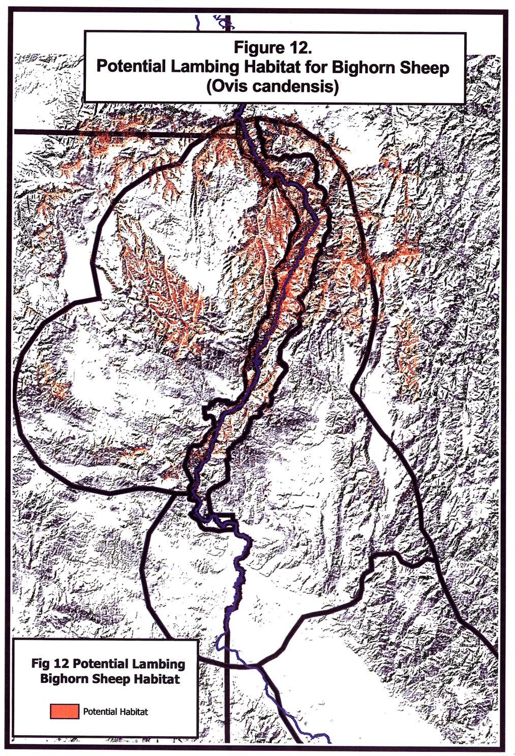
88
89 11. APPENDICES
90
91 $33(1',;$ LIST OF KEY RESOURCE SPECIALISTS AND THEIR AGENCY AFFILIATION $
92
93
94
95
96
97
98
99 $33(1',;% LIST OF HABITAT EFFECTIVENESS FACTORS - HCHC PROJECT LIST %
100
101
102
103 $33(1',;& LIST OF LIMITING FACTORS (M.A.P. HABITAT TM PROJECT ORIGIN) &
104
105
106 7KLVSDJHOHIWEODQNLQWHQWLRQDOO\
107 $33(1',;' LIST OF HABITAT EFFECTIVENESS FACTORS - MULE DEER WORKING GROUP '
108
109
110
111
112
113
114 7KLVSDJHOHIWEODQNLQWHQWLRQDOO\
115 $33(1',;( PRO-CITE TM DATABASE WITH LITERATURE REVIEW RESULTS (
116
117
118
119
120
121
122 7KLVSDJHOHIWEODQNLQWHQWLRQDOO\
123 $33(1',;) TERMS, DEFINITIONS, AND MAPPING CONVENTIONS: DIRECTIONS TO KEY RESOURCE SPECIALISTS )
124
125
126
127
128
129
130
131
132 7KLVSDJHOHIWEODQNLQWHQWLRQDOO\
133 $33(1',;* MAPPING SESSIONS PARTICIPANT, LOCATION OF MEETINGS AND DATES *
134
135
136 7KLVSDJHOHIWEODQNLQWHQWLRQDOO\
137 $33(1',;+ PRO-CITE TM DATABASE KEY RESOURCE SPECIALISTS COMMENTS FROM HABITAT MAPPING MEETINGS +
138
139
140
141
142
143
144
145

146
147
148
149
150 7KLVSDJHOHIWEODQNLQWHQWLRQDOO\
151 $33(1',;, SUMMARY OF HABITAT EFFECTIVENESS FACTORS FOR ELK,
152
153
154
155
156
157 $33(1',;- SUMMARY OF HABITAT EFFECTIVENESS FACTORS FOR MULE DEER -
158
159
160
161
162
163 $33(1',;. MITIGATION MEASURES AND MANAGEMENT RECOMMENDATIONS PROVIDED BY RESOURCE SPECIALISTS EXCEL FILE.
164

165 'DUO\Ã0HLW]B0LWLJDWLRQÃ0HDVXUHVÃ

166 %UXFHÃ3DOPHU5DQG\Ã6PLWKB0LWLJDWLRQÃ0HDVXUHVÃ

167 /RXÃ1HOVRQB0LWLJDWLRQÃ0HDVXUHVÃ

168 -D\Ã&UHQVKDZB0LWLJDWLRQÃ0HDVXUHVÃ
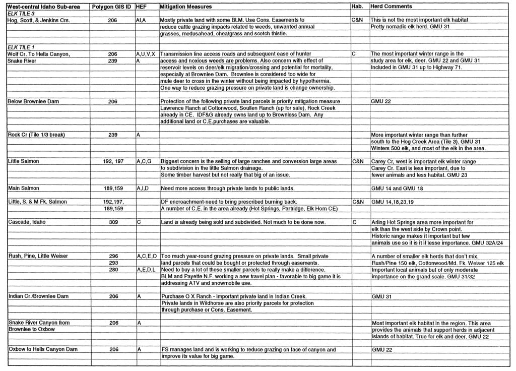
169 -HIIÃ5RKOPDQB0LWLJDWLRQÃ0HDVXUHVÃ
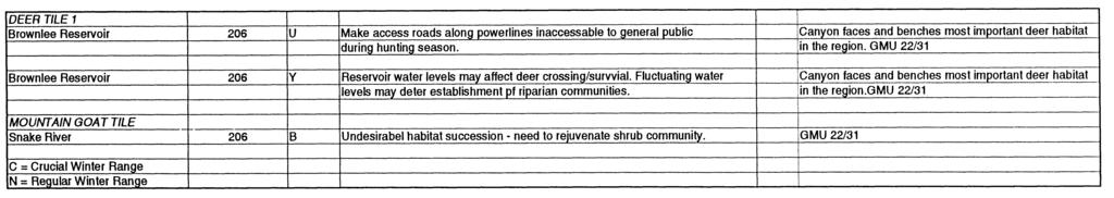
170 -HIIÃ5RKOPDQB0LWLJDWLRQÃ0HDVXUHVÃ

171 2UHJRQÃ5HVRXUFHÃ6SHFLDOLVWVB0LWLJDWLRQÃ0HDVXUHVÃ
ROUTE ANALYSIS PROCESS
 ROUTE ANALYSIS PROCESS Progress to Date: 1. Recorded and labeled all routes received from PAT Meetings. 2. Determined opportunity, avoidance and exclusion areas crossed by PAT proposed routes. 3. Routes
Keeping Wilderness Wild: Increasing Effectiveness With Limited Resources
 Keeping Wilderness Wild: Increasing Effectiveness With Limited Resources Linda Merigliano Bryan Smith Abstract Wilderness managers are forced to make increasingly difficult decisions about where to focus
Wilderness Areas Designated by the White Pine County bill
 Wilderness Areas Designated by the White Pine County bill SEC. 321. SHORT TITLE. This subtitle may be cited as the `Pam White Wilderness Act of 2006'. SEC. 322. FINDINGS. Congress finds that-- The White
2.0 Physical Characteristics
 _ 2.0 Physical Characteristics 2.1 Existing Land Use for the Project The site is comprised of approximately 114 acres bounded by Highway 101 to the north, the existing town of Los Alamos to the east, State
NOTICE OF INTENT MAPS WITH DESCRIPTIONS
 NOTICE OF INTENT MAPS WITH DESCRIPTIONS Location Map(s) to Accompany Notice of Intent The small corner map embedded in the lower left corner of the large map above shows the location of the three national
Map 1.1 Wenatchee Watershed Land Ownership
 Map 1.1 Wenatchee Watershed Land Ownership Map 1.1 Wenatchee Watershed Land Ownership The Wenatchee watershed lies in the heart of Washington state in Chelan County. Just larger than the state of Rhode
Frizzell Creek Ranch Summerville, OR $1,400, ± Acres
 Frizzell Creek Ranch Summerville, OR $1,400,000 165± Acres 1 Introduction The Frizzell Creek Ranch is a beautiful 165± acre ranch located in northeast Oregon at the base of the Wallowa Whitman National
IMPORTANT PLANT AREA NOMINATION FORM MONTANA. Nominated Site Name: South Pryor Mountains Important Plant Area (IPA)
") IMPORTANT PLANT AREA NOMINATION FORM MONTANA Nominated Site Name: South Pryor Mountains Important Plant Area (IPA) General Location: The South Pryor Mountains IPA is located between the Bighorn River on
IMPORTANT PLANT AREA NOMINATION FORM MONTANA Nominated Site Name: South Pryor Mountains Important Plant Area (IPA) General Location: The South Pryor Mountains IPA is located between the Bighorn River on
BIG ANIMALS and SMALL PARKS: Implications of Wildlife Distribution and Movements for Expansion of Nahanni National Park Reserve. John L.
 BIG ANIMALS and SMALL PARKS: Implications of Wildlife Distribution and Movements for Expansion of Nahanni National Park Reserve John L. Weaver Conservation Report No.1 July 2006 4 SUMMARY The boundaries
The Geological Pacific Northwest. Wednesday February 6, 2012 Pacific Northwest History Mr. Rice
 The Geological Pacific Northwest Wednesday February 6, 2012 Pacific Northwest History Mr. Rice 1 Free Response #2 Please do not simply list the items for this response. Full sentences!!! Minimum of 3-5
IMPORTANT PLANT AREA NOMINATION FORM MONTANA. Nominated Site Name: Big Sheep Creek Basin Important Plant Area (IPA)
") IMPORTANT PLANT AREA NOMINATION FORM MONTANA Nominated Site Name: Big Sheep Creek Basin Important Plant Area (IPA) General Location: Big Sheep Creek Basin is a located between the Beaverhead (on the west)
IMPORTANT PLANT AREA NOMINATION FORM MONTANA Nominated Site Name: Big Sheep Creek Basin Important Plant Area (IPA) General Location: Big Sheep Creek Basin is a located between the Beaverhead (on the west)
2.0 PARK VISION AND ROLES
 2.0 PARK VISION AND ROLES 2.1 Significance in the Protected Area System Marble Range and Edge Hills provincial parks protect 6.8% of the Pavillion Ranges Ecosection, which is located in the Southern Interior
Decision Memo for Desolation Trail: Mill D to Desolation Lake Trail Relocation
 for Salt Lake County, Utah Uinta-Wasatch-Cache National Forest Salt Lake Ranger District 1. Background The present location of the Desolation Trail (#1159) between Mill D and Desolation Lake follows old
April 10, Mark Stiles San Juan Public Lands Center Manager 15 Burnett Court Durango, CO Dear Mark,
 Mark Stiles San Juan Public Lands Center Manager 15 Burnett Court Durango, CO 81301 Dear Mark, We are pleased to offer the following comments on the draft San Juan Public Lands Center management plans
HIGH COUNTRY L-BAR RANCH
 HIGH COUNTRY L-BAR RANCH Sandoval and mckinley counties N e w m e x i c o Jim Haworth, Ranch Team Lead Broker ~ 505-235-5236 3613 NMSR 528 NW, Ste. H, Albuquerque, NM 87114 505-792-3713 www.wwrealty.com
Subject to sale, withdrawal, or error.
 The Crawford L Bar Ranch is located approximately 40 air miles west of Albuquerque, New Mexico. This ranch truly epitomizes the description of New Mexico being the Land of Enchantment. The topography and
Chapter 2: El Dorado County Characteristics and Demographics
 Chapter 2: El Dorado County Characteristics and Demographics 2.1 Geographic Area and Demographics El Dorado County comprises 1,805 square miles with over half of the area in the Eldorado National Forest
B HALL RANCH FISHTAIL, MONTANA
 Brochure Courtesy of: B HALL RANCH FISHTAIL, MONTANA w w w. m c c a s l i n l a n d. c o m Page 1 LOCATION The Hall Ranch is ideally located in the foothills of the Beartooth Mountains, approximately 5
Proposed Action. Payette National Forest Over-Snow Grooming in Valley, Adams and Idaho Counties. United States Department of Agriculture
 United States Department of Agriculture Forest Service January 2012 Proposed Action Payette National Forest Over-Snow Grooming in Valley, Adams and Idaho Counties Payette National Forest Valley, Adams
Sawtooth National Forest Fairfield Ranger District
 United States Department of Agriculture Forest Service Sawtooth National Forest Fairfield Ranger District P.O. Box 189 Fairfield, ID. 83327 208-764-3202 Fax: 208-764-3211 File Code: 1950/7700 Date: December
PAUL S PLACE ELK, DEER AND VIEWS FISHTAIL, MONTANA
 McCaslin Land 2010 PAUL S PLACE ELK, DEER AND VIEWS FISHTAIL, MONTANA LOCATION Paul s Place is ideally located in the foothills of the Beartooth Mountains, approximately 5 to 5-1/2 miles west of Fishtail,
AURORA WILDLIFE RESEARCH
 AURORA WILDLIFE RESEARCH Kim Poole 2305 Annable Rd. Nelson, BC, V1L 6K4 Canada Tel: (250) 825-4063; Fax: (250) 825-4073 e-mail: klpoole@shaw.ca 27 April 2005 Mike Gall Conservation Specialist and Glenn
Phoenix Habitat Restoration Projects
 Phoenix Habitat Restoration Projects Spur Cross Ranch Cave Creek (Estergard) Regional Tree and Shade Summit March 9, 2010 Desert Riparian Ecosystems Healthy riparian areas like this once existed along
SECTION 3 GENERAL DESCRIPTION OF THE RIVER BASIN
 SECTION 3 GENERAL DESCRIPTION OF THE RIVER BASIN SECTION 3 GENERAL DESCRIPTION OF THE RIVER BASIN River basin description. A general description of the river basin or subbasin, as appropriate, in which
APPENDIX G. The WAP Conservation Landscape and Focal Areas
 APPENDIX G The WAP Conservation Landscape and Focal Areas Focal areas were identified as discrete landscape units using the natural basin and range geography of the Nevada landscape. These units were prioritized
26 Utah s Patchwork Parkway SCENIC BYWAY CORRIDOR MANAGEMENT PLAN (SR 143)
") Natural Natural Quality applies to those features in the visual environment that are in a relatively undisturbed state. These features predate the arrival of human populations and may include geological
Natural Natural Quality applies to those features in the visual environment that are in a relatively undisturbed state. These features predate the arrival of human populations and may include geological
(Short Listing) DUPUYER ACREAGE, ROCKY MOUNTAN FRONT
 DUPUYER ACREAGE, ROCKY MOUNTAN FRONT") (Short Listing) DUPUYER ACREAGE, ROCKY MOUNTAN FRONT This unique property is located 8½ miles northwest of Dupuyer, Montana and approximately thirty 30 miles northwest of Choteau, Montana. Great Falls
(Short Listing) DUPUYER ACREAGE, ROCKY MOUNTAN FRONT This unique property is located 8½ miles northwest of Dupuyer, Montana and approximately thirty 30 miles northwest of Choteau, Montana. Great Falls
Susitna-Watana Hydroelectric Project (FERC No ) Recreation Resources Study Study Plan Section Study Implementation Report
 Recreation Resources Study Study Plan Section Study Implementation Report") (FERC No. 14241) Recreation Resources Study Study Plan Section 12.5 2014 Study Implementation Report Prepared for Prepared by AECOM November 2015 TABLE OF CONTENTS 1. Introduction... 4 2. Study Objectives...
(FERC No. 14241) Recreation Resources Study Study Plan Section 12.5 2014 Study Implementation Report Prepared for Prepared by AECOM November 2015 TABLE OF CONTENTS 1. Introduction... 4 2. Study Objectives...
Mark West Creek Flow Study Report
 Mark West Creek Flow Study Report Biology and Geology of Mark West Creek The headwaters of Mark West Creek are located in the Mayacamas Mountain range, which border Napa and Sonoma County, where it then
Preferred Recreation Recommendations Stemilt-Squilchuck Recreation Plan March 2018
 Preferred Recreation Recommendations Stemilt-Squilchuck Recreation Plan March 2018 Below are the recommended recreation ideas and strategies that package together the various recreation concepts compiled
Piedra River Protection Workgroup Meeting #5 Feb. 21, 2012 Ross Aragon Community Center, Pagosa Springs
 Piedra River Protection Workgroup Meeting #5 Feb. 21, 2012 Ross Aragon Community Center, Pagosa Springs What happened at this meeting? - Identified conservation easements - Discussed In-stream Flows -
Appendix D Explanation of Route Changes. Prepared by: Idaho Power Company 1221 W Idaho Street Boise, ID 83702
 Appendix D Explanation of Route Changes Prepared by: Idaho Power Company W Idaho Street Boise, ID 80 Map Label ID 6 Route Reference Added November 0 Horn Butte Substation Added November 0 Horn Butte Eliminated
Outreach Notice. FREMONT-WINEMA NATIONAL FOREST Zone Planning Staff GS Winter Rim Zone Paisley and Silver Lake Ranger Districts
 Outreach Notice FREMONT-WINEMA NATIONAL FOREST Zone Planning Staff GS-0401-11 Winter Rim Zone Paisley and Silver Lake Ranger Districts The Position This position is located on the Winter Rim Zone, Fremont-Winema
Bayview Escarpment. Interim Management Statement
 Bayview Escarpment Interim Management Statement Bayview Escarpment Provincial Nature Reserve Interim Management Statement January 15, 1995 REGIONAL DIRECTOR'S APPROVAL STATEMENT This Interim Management
MANAGEMENT DIRECTION STATEMENT June, 1999
 Thompson River District MANAGEMENT DIRECTION STATEMENT June, 1999 for Clearwater River Corridor (Addition to Wells Gray Park) Ministry of Environment Lands and Parks BC Parks Division ii Table of Contents
Town of Oakfield Agricultural and Farmland Protection Plan
 SECTION III COMMUNITY OVERVIEW A. Regional Setting / Location The Town of Oakfield is located in the northwestern portion of Genesee County. Located west of New York's Finger Lakes, the Town is uniquely
A GIS Analysis of Probable High Recreation Use Areas in Three Sisters Wilderness Deschutes and Willamette National Forests
 Lindsey Kiesz Geo 565 Term Project 3/15/2010 A GIS Analysis of Probable High Recreation Use Areas in Three Sisters Wilderness Deschutes and Willamette National Forests Introduction The Three Sisters Wilderness
Daisy Dean Trail 628/619 ATV Trail Construction
 Background and Purpose and Need The Daisy Dean ATV Trail Construction Project is located in the Little Belt Mountains, Musselshell Ranger District, Lewis and Clark National Forest approximately 32 miles
The following criteria were used to identify Benchmark Areas:
 7.0 BENCHMARK AREAS The Churn Creek Protected Area offers a significant opportunity to learn more about how grassland ecosystems function. One of the key tools that will be used to monitor larger grassland
The Design of Nature Reserves
 The Design of Nature Reserves Goals Maintenance of MVP s for targeted species Maintenance of intact communities Minimization of disease Considerations of reserve design 1. Disturbance regime Fire Insect
Swan Valley Farms. 523 acres for sale in Bonneville County, ID JIMMY ROUMANIS. JOHN STARR
 Swan Valley Farms JOHN STARR 208 472 2838 john.starr@colliers.com 523 acres for sale in Bonneville County, ID JIMMY ROUMANIS 208 472 2840 jimmy.roumanis@colliers.com Swan Valley Farms- 523 acres for sale
Wyoming Public Lands Initiative in Carbon County
 Wyoming Public Lands Initiative in Carbon County THE CARBON COUNTY WPLI ADVISORY COMMIT TEE WANTS YOUR INPUT Wilderness Study Area: A special designation that applies to lands managed to protect wilderness
Eagle Pinon Ranch. 2,963 +/- acres, Hudspeth County
 Eagle Pinon Ranch 2,963 +/- acres, Hudspeth County Eagle Piñon Ranch 2963 acres Hudspeth County, Texas Location The Eagles are part of a chain of sky island mountains that stretch from New Mexico through
Region 1 Piney Woods
 Region 1 Piney Woods Piney Woods 1. This ecoregion is found in East Texas. 2. Climate: average annual rainfall of 36 to 50 inches is fairly uniformly distributed throughout the year, and humidity and temperatures
Blanco Creek Ranch Acres, Uvalde County, Texas
 Blanco Creek Ranch 1208.30 Acres, Uvalde County, Texas James King, Agent Office 432 426.2024 Cell 432 386.2821 James@KingLandWater.com Blanco Creek Ranch 1208.30 acres Uvalde County, Texas James King,
INTRODUCTION 250,000
 INTRODUCTION The United States of America has over 250,000 rivers, with a total of about 3,500,000 miles of rivers. The main stems of 38 rivers in the United States are at least 500 miles (800 km) long.
Lewis and Clark National Historic Trail
 National Trails System Land and Water Conservation Fund FY2014 Lewis and Clark National Historic Trail Total LWCF Request: $ 3,130,000 Project Name Agency District # Tracts Acres Total Cost Columbia River
DOYLE SPRINGS PLANNING UNIT Kern-Tule River Watershed
 Existing Conditions & Uses Overview Consists of a mostly forested parcel with small hydropower developments and part of a private recreation cabin development, along with two small transmission line corridor
ANAGEMENT. LAN November, 1996
 M ANAGEMENT P LAN November, 1996 for Paul Lake Provincial Park Ministry of Environment, Lands and Parks BC Parks Department Paul Lake Provincial Park M ANAGEMENT P LAN Prepared by BC Parks Kamloops Area
Environmental Development of River Road Ranch
 Environmental Development of River Road Ranch New Braunfels, Texas Alix Scarborough GEO 3426 April 2012 Introduction The 2,400-acre Word-Borcher ranch has been owned by the Word family since 1941. Located
Whitemouth Falls Provincial Park. Draft Management Plan
 Whitemouth Falls Provincial Park Draft Management Plan Whitemouth Falls Provincial Park Draft Management Plan Table of Contents 1. Introduction... 3 2. Park History... 3 3. Park Attributes... 4 3.1 Natural...
Connie Rudd Superintendent, Black Canyon of the Gunnison National Park
 National Park Service U.S. Department of the Interior Black Canyon of the Gunnison National Park and Curecanti National Recreation Area Information Brochure #1 Wilderness and Backcountry Management Plan
EXPLORING BIOMES IN GORONGOSA NATIONAL PARK
 EXPLORING BIOMES IN GORONGOSA NATIONAL PARK ABOUT THIS WORKSHEET This worksheet complements the Click and Learn Gorongosa National Park Interactive Map (http://www.hhmi.org/biointeractive/gorongosa-national-park-interactive-map),
ALBERTA S GRASSLANDS IN CONTEXT
 ALBERTA S GRASSLANDS IN CONTEXT GLOBAL GRASSLANDS 1 Temperate grasslands, located north of the Tropic of Cancer and south of the Tropic of Capricorn, are one of the world s great terrestrial biomes 2.
Special Recreation Management Areas Extensive Recreation Management Areas Public Lands Not Designated as Recreation Management Areas
 From the Proposed RMP: Special Recreation Management Areas SRMAs are an administrative unit where the existing or proposed recreation opportunities and recreation setting characteristics are recognized
CABARTON RANCH NORTH EXECUTIVE SUMMARY
 EXECUTIVE SUMMARY O ffering breath-taking scenery and serene privacy, the 705 + acre Cabarton Ranch North is nestled at the base of West Mountain in the southwestern-edge of Valley County, near Lake Cascade,
Pinellas County Environmental Lands
 Pinellas County Environmental Lands In addition to traditional parks and recreation facilities, Pinellas County owns and manages a system of environmental lands that provides specialized resource-based
Mackinnon Esker Ecological Reserve Draft - Management Plan
 Mackinnon Esker Ecological Reserve Draft - Management Plan May 2011 Photo Credit: This document replaces the direction provided in the Carp Lake Provincial Park and Protected Area and Mackinnon Esker Ecological
Creating a User-Driven Long-Distance OHV Trail Through Partnering
 Joseph Raffaele Outdoor Recreation Planner U.S. Bureau of Land Management Yuma, Arizona Creating a User-Driven Long-Distance OHV Trail Through Partnering BLM is a multiple-use land management agency within
Colorado Life Zone Scavenger Hunt
 Colorado Life Zone Scavenger Hunt Below are worksheets created for all the habitats or life zones. They were designed with the intention of breaking the class up into small groups, and having students
BUCK POINT RANCH. Aspen Associates Realty
 BUCK POINT RANCH Aspen Associates Realty www.aspenassociatesrealty.com 970.544.5800 WELCOME TO Buck Point Ranch is a 960± acre property located in one of the last pristine valleys in close proximity to
ELKHORN MOUNTAINS PAST, PRESENT, FUTURE PROJECTS
 ELKHORN MOUNTAINS PAST, PRESENT, FUTURE PROJECTS AUGUST 2001 1992 - The Elkhorn MOU among the Helena NF, Deerlodge NF, Bureau of Land Management, and Montana Dept. Fish, Wildlife and Parks was signed establishing
Existing Resource Information
 Botanical and Wildlife Vegetation alliances/wildlife habitats Grasslands annual/perennial Chaparral mixed/montane/chamise-redshank Riparian montane/valley foothill riparian Sierran mixed conifer Montane
Role of the Protected Area
 Role of the Protected Area Provincial and Regional Context Height of the Rockies and Elk Lakes provincial parks lie in southeastern British Columbia in the Rocky Mountains, about 85 km southwest of Calgary,
SHASTA WEST PLANNING AREA
 2016 SHASTA COUNTY COMMUNITY WILDFIRE PROTECTION PLAN SHASTA WEST PLANNING AREA Covering the communities of: Centerville Redding (west & downtown) Shasta I. PROPOSED PROJECTS A. THE PLANNING AREA SHASTA
Brinker Creek Ranch. Colorado - Routt County - Yampa
 Located at the base of the Flattops Range in the Steamboat/Vail corridor, Brinker Creek Ranch consists of 1,451 acres ideally suited for high country grazing and native grass hay production. Traditionally
TAYLOR CANYON RANCH COLORADO - ROUTT COUNTY - STEAMBOAT SPRINGS
 TAYLOR CANYON RANCH COLORADO - ROUTT COUNTY - STEAMBOAT SPRINGS Tucked up against the steep valley shaped by Mt. Pau and rising to the Routt National Forest, Taylor Canyon Ranch is an easily accessible,
Bradley Brook Relocation Project. Scoping Notice. Saco Ranger District. United States Department of Agriculture Forest Service
 Bradley Brook Relocation Project United States Department of Agriculture Forest Service Scoping Notice White Mountain National Forest February 2011 For Information Contact: Jenny Burnett White Mountain
Non-motorized Trail Plan & Proposal. August 8, 2014
 Town of Star Valley Ranch, Wyoming and the Star Valley Ranch Association in partnership with the USDA Forest Service, Bridger-Teton National Forest, Greys River Ranger District Non-motorized Trail Plan
Hudson Bay Lowlands Proposed Protected Areas
 Hudson Bay Lowlands Proposed Protected Areas Hudson Bay Lowlands Proposed Protected Areas The Protected Areas Initiative has identified portions of the Hudson Bay Lowlands region that have significant
KANANASKIS COUNTRY PROVINCIAL RECREATION AREAS MANAGEMENT PLAN DRAFT TERMS OF REFERENCE - November 20, 2007
 KANANASKIS COUNTRY PROVINCIAL RECREATION AREAS MANAGEMENT PLAN DRAFT TERMS OF REFERENCE - November 20, 2007 BACKGROUND There are 42 Provincial Recreation Areas (PRAs) within Kananaskis Country located
Appalachian Power Company Smith Mountain Hydroelectric Project FERC No Debris Management Plan
 Appalachian Power Company Smith Mountain Hydroelectric Project FERC No. 2210 Debris Management Plan Final July2008 TABLE OF CONTENTS Description Page SUMMARY 1 1.0 Introduction.. 2 1.1 Project Lands and
X. WHATCOM CREEK SMA. X.1 Watershed Analysis. X.1.1 Landscape Setting
 X. WHATCOM CREEK SMA Summary: The entire length of Whatcom Creek is located within the City of Bellingham. SMA jurisdiction associated with this creek is approximately 300 acres. Land use is dominated
ECORREGIONAL ASSESSMENT: EASTERN CORDILLERA REAL ORIENTAL PARAMOS AND MONTANE FORESTS
 ECORREGIONAL ASSESSMENT: EASTERN CORDILLERA REAL ORIENTAL PARAMOS AND MONTANE FORESTS The Nature Conservancy, EcoCiencia y Fundación AGUA. 2005. Evaluación Ecorregional de los Páramos y Bosques Montanos
II. GENERAL DESCRIPTION OF ENVIRONMENTAL SETTING
 II. GENERAL DESCRIPTION OF ENVIRONMENTAL SETTING A. LOCATION AND BOUNDARIES The proposed Canyon Hills project site is located at 8000 West La Tuna Canyon Road in the City of Los Angeles (the City ). The
Kicking the Alpine Plants Out Mountain Goat Wallows In Mount Peale Research Natural Area (La Sal Mountains, Utah)
") Kicking the Alpine Plants Out Mountain Goat Wallows In Mount Peale Research Natural Area (La Sal Mountains, Utah) Marc Coles-Ritchie, Grand Canyon Trust November 21, 2017 Mountain goats are digging up
Kicking the Alpine Plants Out Mountain Goat Wallows In Mount Peale Research Natural Area (La Sal Mountains, Utah) Marc Coles-Ritchie, Grand Canyon Trust November 21, 2017 Mountain goats are digging up
General Overview: Acreage:
 General Overview: The Beaver Creek Ranch is located on Beaver Creek in Shell Wyoming, at the base of the western slope of the Big Horn Mountains, one of the west s most spectacular back drops. With an
WALKER RANCH MANAGEMENT PLAN
 WALKER RANCH MANAGEMENT PLAN Boulder County Parks and Open Space Walker Ranch Management Plan July 2013 The Walker Ranch Management Plan provides guidance to Boulder County Parks and Open Space on management
Treaty Oaks Ranch 323+/- Acres Hood County, Texas $1,776,500
 Bret Polk Mobile: (254) 965-0349 Office: (214) 361-9191 Treaty Oaks Ranch 323+/- Acres Hood County, Texas $1,776,500 LOCATION: The ranch is located in a desirable area 10+/- miles south of Granbury, Texas,
ROAD AND TRAIL PROJECT APPROVAL
 ROAD AND TRAIL PROJECT APPROVAL www.marincountyparks.org Marin County Parks, 3501 Civic Center Dr, Suite 260, San Rafael, CA 94903 DATE: July 12, 2017 PRESERVE: Gary Giacomini Open Space Preserve PROJECT:
Biosphere Reserves of India : Complete Study Notes
 Biosphere Reserves of India : Complete Study Notes Author : Oliveboard Date : April 7, 2017 Biosphere reserves of India form an important topic for the UPSC CSE preparation. This blog post covers all important
South Texas Plains. Texas, Our Texas
 South Texas Plains This is a region characterized by considerable variety. Climatically, the South Texas Plains region is sub-humid to dry. The in the north part of the South Texas, erosion of the Edwards
Bear Creek Habitat Improvement Project
 06/10/10 Bear Creek Habitat Improvement Project El Paso County, Colorado Pike National Forest and Colorado Springs Utilities Owned Land Report prepared by: Eric Billmeyer Executive Director Rocky Mountain
Marchand Provincial Park. Management Plan
 Marchand Provincial Park Management Plan 2 Marchand Provincial Park Table of Contents 1. Introduction... 3 2. Park History... 3 3. Park Attributes... 4 3.1 Natural... 4 3.2 Recreational... 4 3.3 Additional
Lands with Wilderness Characteristics: Chipeta and Pahlone Foothills
 Lands with Wilderness Characteristics: Chipeta and Pahlone Foothills Ouray, Chipeta, and Pahlone Peaks over interior unit, Royal Gorge Field Office Photo: John Sztukowski The intent of this report is to
Spatial Distribution and Characteristics of At-Risk Species in the Southeast U.S.
 Nicholas Institute for Environmental Policy Solutions Scoping Document Part 2 Exploratory Analysis of Characteristics and Trends of At-Risk Species in the Southeast U.S. Spatial Distribution and Characteristics
The Sand Ridge - Tulare Lake Conservation Report proposes the following recommendations:
 Introduction Creighton Ranch. Pixley National Wildlife Refuge. Allensworth State Historic Park. Sand Ridge. Deer Creek. Located in the Tulare Lake Basin, the Sand-Ridge - Tulare Lake Planning Area features
LITTLE LOST MAN CREEK (LLM) (formerly USGS Gaging Station No )
 (formerly USGS Gaging Station No )") LITTLE LOST MAN CREEK (LLM) (formerly USGS Gaging Station No. 11482468) LOCATION: In Redwood National and State Park approximately 0.8 miles upstream from confluence with Prairie Creek and 3.2 miles northeast
LITTLE LOST MAN CREEK (LLM) (formerly USGS Gaging Station No. 11482468) LOCATION: In Redwood National and State Park approximately 0.8 miles upstream from confluence with Prairie Creek and 3.2 miles northeast
VOLUME II APPENDIX F DETAILED PHYSICAL DESCRIPTION OF PROJECT RESERVOIRS AND LANDS
 VOLUME II APPENDIX F DETAILED PHYSICAL DESCRIPTION OF PROJECT RESERVOIRS AND LANDS THE CENTRAL NEBRASKA PUBLIC POWER AND IRRIGATION DISTRICT FERC PROJECT NO. 1417 PHYSICAL DESCRIPTION OF PROJECT LANDS
Section II. Planning & Public Process Planning for the Baker/Carver Regional Trail began in 2010 as a City of Minnetrista initiative.
 Section II Planning & Public Process Planning for the began in 2010 as a City of initiative. city staff began discussions with the Park District on the possibility of a north/south regional trail connection
Weston County, Wyoming
 The Sweet 200-Acre Property Weston County, Wyoming A unique opportunity to own a little piece of the old West, where one can experience unparalleled scenery, adventure and history walk in the footsteps
CONSERVATION PLAN FOR THE CARTER PROPERTY BEAR LAKE COUNTY, IDAHO
 CONSERVATION PLAN FOR THE CARTER PROPERTY BEAR LAKE COUNTY, IDAHO Prepared By John Carter P.O. Box 280 Mendon, Utah 84325 435-881-1232 IINTRODUCTION In 1993, I began acquiring land in Paris Canyon, Idaho
MANAGEMENT DIRECTION STATEMENT February 2001
 Thompson River District MAAGEMET DIRECTIO STATEMET February 2001 for Greenstone Mountain Provincial Park Ministry of Environmen Lands and Parks BC Parks Division Table of Contents Introduction... 1 Purpose
MANAGEMENT DIRECTION STATEMENT June, 1999
 Thompson River District MANAGEMENT DIRECTION STATEMENT June, 1999 for Roche Lake Provincial Park Ministry of Environment Lands and Parks BC Parks Division Table of Contents I. Introduction A. Setting
Dixon Trail Construction - From the Top of the Mountain 2016 Interim Report Friends of Cheyenne Mountain State Park September 2 nd, 2016
 - Dixon Trail Construction - From the Top of the Mountain 2016 Interim Report Friends of Cheyenne Mountain State Park September 2 nd, 2016 Prepared by: Andy Riter, Program Coordinator, and Joe Lavorini,
Evaluation of Outstanding Remarkable Values for Collawash River March 2011
 Evaluation of Outstanding Remarkable Values for Collawash River March 0 Segment From headwaters of East Fork Collawash River to Buckeye Creek Mileage: miles Free flowing: Yes Scenic:, Substantial River
Hartsel Springs Ranch 4,637 Acres Park County, Colorado $4,780,000
 Hartsel Springs Ranch 4,637 Acres Park County, Colorado $4,780,000 Presented By: Farm, Ranch & Recreational Real Estate Hartsel Springs Ranch 4,637 Acres Park County, Colorado $4,780,000 Property Description
Michipicoten Island Regional Plan
 Michipicoten Island Regional Plan This is one of twenty Regional Plans that support implementation of the Lake Superior Biodiversity Conservation Strategy (Strategy). The Strategy, prepared and overseen
Robson Valley Avalanche Tract Mapping Project
 Robson Valley Avalanche Tract Mapping Project Prepared for: Chris Ritchie Ministry of Water Land and Air Protection 325 1011 4th Avenue Prince George, BC. V2L3H9 and Dale Seip Ministry of Forests 1011
Planning Wildlife Crossings in Canada's Mountain Parks SESSION: Highway Mitigation: new insights for practitioners
 Planning Wildlife Crossings in Canada's Mountain Parks ID95 SESSION: Highway Mitigation: new insights for practitioners Trevor Kinley, Project Manager Lake Louise Yoho Kootenay Field Unit, Parks Canada