IMPORTANT PLANT AREA NOMINATION FORM MONTANA. Nominated Site Name: South Pryor Mountains Important Plant Area (IPA)
|
|
|
- Chad Douglas
- 5 years ago
- Views:
Transcription
1 IMPORTANT PLANT AREA NOMINATION FORM MONTANA Nominated Site Name: South Pryor Mountains Important Plant Area (IPA) General Location: The South Pryor Mountains IPA is located between the Bighorn River on the east and the Clark s Fork of the Yellowstone River on the west, the Wyoming state line on the south in Carbon County ca. 50 miles south of Billings, Montana. The IPA includes most of the south-facing drainages of the Pryor Mountains, including from east to west; Davis Creek, Trail Creek, Layout Creek, Big Coulee, Crooked Creek, Gypsum Creek and Bear Creek. Site Coordinates: Boundary Coordinates: Northwest: 45 11' ' Southeast: 45 0' ' including portions of the following Township/Ranges:T7S R27E, T8S R26E, T8S R27E, T8S R28E, T8S R29E, T9S R26E, T9S R27E, T9S R28E, T9S, R29E Maps: (1) IPA boundary, ownership and location of SOC species Photographs: Landscape photographs as well as photos of Erigeron allocotus, Penstemon caryi, Physaria lesicii, Shoshonea pulvinata, and Sullivantia hapemanii. Counties: Carbon Co. Elevation: 3,680 ft on the Bighorn River to 8,770 ft on the summit of East Pryor Mountain. Size of Area: 114,950 acres Property Ownership: Bureau of Land Management, U.S. Forest Service, National Park Service, State of Montana, and private. Other designations for the site: East Pryor Mountain Area of Critical Environmental Concern (BLM), Lost Water Canyon Research Natural Area (USFS). Burnt Timber Canyon Wilderness Study Area (BLM) Pryor Mountain Wilderness Study Area (BLM), Pryor Mountain Wildhorse Range (BLM), Bighorn Canyon National Recreation Area (NPS), Bear Canyon Important Bird Area (Audubon, USFS, BLM). 1
2 Table 1. Plant Species of Concern in the South Pryor Mountains IPA Species MNHP MNHP Last Population Trend global state observed size Astragalus aretioides G4 S2S Unknown Astragalus geyeri G4 S Unknown Astragalus oreganus G4? S ,000+ Unknown Boechera demissa G5 S1S Unknown Unknown Camissonia andina G4 S ,000-10,000 Unknown Camissonia parvula G5 S1S ,000 Unknown Cleome lutea G5 S1S Unknown Unknown Erigeron allocotus G3 S ,000+ Unknown likely Eriogonum salsuginosum G4? S Approx 1,000 Unknown Grayia spinosa G5 S Approx 1,000 Unknown Leptodactylon caespitosum G4 S ,000-5,000 Unknown Malacothrix torreyi G4 S1S Unknown Unknown Mentzelia pumila G4 S2S Unknown Unknown Nama densum G5 S ,000 Unknown Penstemon caryi G3 S Unknown Unknown Physaria lesicii G2 S ,000+ Unknown Shoshonea pulvinata G2G3 S ,000-5,000 Possibly declining (Heidel 2001) Stipa lettermanii G5 S1S Unknown Unknown Sullivantia hapemanii G3 S ,000+ Unknown Rhizoplaca haydenii (Lichen) G2G3 S1S Unknown Unknown Trend Information: Trend data are lacking for almost all plant SOC within the proposed IPA. Only Shoshonea pulvinata has monitoring data available. In permanent monitoring transects were established for Shoshonea pulvinata, two of these are within the proposed IPA boundary near Mystery Cave. Transects were read from 1991 to 1993 and again in Populations remained stable at 2 sites, including one on the east slope of the Beartooth Plateau, while the Mystery Ridge transect within the prosed IPA showed a steep decline between and an overall declining trend during the monitoring period (Heidel 2001). Threats: Threats to the rare in the South Pryor Mountains proposed IPA include off-road vehicle use, trampling by livestock and wild horses, weed invasion, mineral exploration and extraction, and climate change. Most of the rare occur in open habitats that could be 2
3 negatively impacted by soil erosion or compaction from off-road vehicle use or mining exploration. Halogeton glomeratus is a pernicious weed in Wyoming and south and occurs in some low-elevation portions of the proposed IPA. Trampling by wild horses has caused terracing and degradation of Physaria lesicii habitat on Sykes Ridge (Lesica 1995). Sullivantia hapemanii occurs in seeps along Bighorn Canyon. Changes in hydrology associated with a drying or warming climate could cause loss of habitat for this species. Table 2. Type and severity of threats for rare in the South Pryor Mountains IPA Species Threats Level Comments All but Shoshonea and Sullivantia Weed Invasion Low Halogeton glomeratus is common in some parts of proposed IPA at lower elevations and could exclude recruitment of native. Low- and midelevation species of open habitats, especially Physaria All species except Sullivantia Sullivantia hapemanii Trampling by livestock and wild horses Off-road vehicle use and mineral exploration and extraction Lowmoderate Low Grazing is present throughout the IPA. Has the potential to damage habitat for Physaria lesicii and other species occupying steep slopes. Limestone and bentonite are currently being mined on the periphery of the IPA. Climate Change Unknown Changes in temperature and water availability could impact the calcareous seep habitat. Justification: The proposed South Pryor Mountains IPA supports a large number of considered rare in Montana. The majority of these are with affinities to the Great Basin floristic province (14 species). They are more common in Wyoming and Utah but reach the northern margin of their range in the South Pryor Mountains area. For all SOC s included in the proposed IPA boundary, the IPA encompasses the entire known range or a significant portion of the known populations of these species within Montana. Five species of vascular are globally rare, being endemic to the north end of the Bighorn Basin of Montana and Wyoming. The proposed South Pryor Mountains IPA has 5,000 ft of vertical relief and supports ca. 29 distinct plant communities (DeVelice and Lesica 1993). Forests and woodlands dominated by limber pine occur on warm, often exposed, stony-soil slopes at or above 6,500 ft. Douglas-fir forests occur on slopes at 5,000-7,000 ft. Woodlands dominated by Utah juniper occur on shallow, calcareous soil of slopes and ridges at 4,000-6,000 ft. Limber pine-juniper woodlands are found on shallow, calcareous soils of slopes between 4,000 ft and 5,300 ft. Shrublands dominated by black sagebrush and big sagebrush occur at 4,200-6,700 ft on slopes, ridgetops and benches. Toeslopes, terraces and alluvial fans at 3,800 ft to 5,300 ft, often with heavy soil, support shrublands dominated by big sagebrush (Artemisia tridentata), bird s-foot sagebrush (Artemisia pedatifida), black greasewood (Sarcobatus vermiculatus), and Gardner s saltbush 3
4 (Atriplex gardneri). Idaho fescue grasslands occur above 8,000 ft on gentle slopes. Grasslands dominated by bluebunch wheatgrass and cushion are common on gravelly soils of lowelevation ridgetops and upper slopes. Several plant communities in the proposed South Pryor Mountains IPA were considered globally rare at the time of the last vegetation survey in the area (DeVelice and Lesica 1993, Lesica 1994). Three of these plant communities deserve mention because they are widespread in the proposed IPA and thought to be globally rare. These are (1) Juniperus osteosperma/cercocarpus ledifolius woodlands, (2) Pinus flexilis/juniperus osteosperma woodlands, and (3) Atriplex nuttallii/artemsisia spinescens shrublands (DeVelice and Lesica 1993, Lesica 1994). These communities are reported to be endemic to the Pryor Mountain Desert and adjacent Northern Bighorn Basin (DeVelice and Lesica 1993). The two woodland communities are common at mid elevations, while the shrubland type was recorded at some of the lowest elevations in the proposed IPA. Further research is needed to determine if other plant communities reported for the area are truly globally rare. The IPA boundary is drawn to contain the highest concentration and exemplary populations of all the rare species and communities. The southern boundary is the Wyoming state line. The east boundary is the Bighorn River which is also the approximate boundary between the Bighorn Canyon National Recreation Area and the Crow Indian Reservation. The north boundary is the summit ridge of the Pryor Mountains. The west boundary was drawn to include Bear Creek Canyon and all of Crooked Creek Canyon. References: DeVelice, R.L. and P. Lesica Plant community classification for vegetation on BLM lands, Pryor Mountains, Carbon County, Montana. Montana Natural Heritage Program, Helena. 40 pp. + appendices. Heidel, B Monitoring Shoshonea pulvinata in the Pryor and Beartooth Mountains, Carbon County, MT trend report to Bureau of Land Management, MT. Montana Natural Heritage Program, Helena. 11 pp. + appendices. Lesica, P Vegetation map of the rare plant community types in the Pryor Mountains and Pryor Mountain Desert, Carbon County, Montana. Montana Natural Heritage Program, Helena. 6 pp. + 6 map sheets. Lesica, P Conservation status of Lesquerella lesicii in Montana. Unpublished report to USDA Forest Service, Missoula, MT and USDI-BLM, Billings, MT. Montana Natural Heritage Program MTNHP Botany Database: Accessed February 4, Montana Natural Heritage Program, Helena. Form submitted by: Peter Lesica and Scott Mincemoyer Affiliation: Montana Native Plant Society Date of Submission: February 2012 Mailing address: 929 Locust, Missoula, MT address: lesica.peter@gmail.com 4


5 Photograph 1. Sagebrush steppe in the foreground; Utah juniper woodlands on red Chugwater sandstone; limber pine woodlands on the foothills in the background. Photograph 2. Utah juniper woodlands in the foreground; limber pine woodlands in the background. 5


6 Photgraph 3. Sagebrush steppe near Gyp Spring. Photograph 4. Cushion plant grasslands in the foreground; Crooked Creek left-center; bentonite hills (mainly in Wyoming) in the background. 6


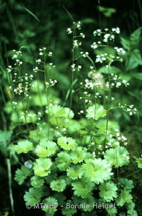
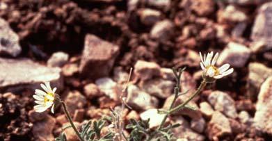
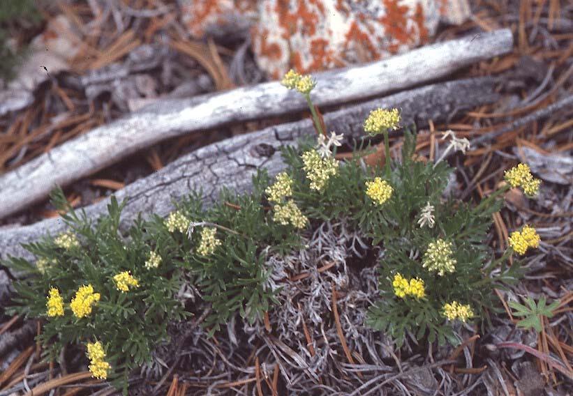
7 Penstemon caryi Physaria lesicii Sullivantia hapemanii Erigeron allocotus Shoshonea pulvinata 7
IMPORTANT PLANT AREA NOMINATION FORM MONTANA. General Location: East end of Centennial Valley approximately 50 miles southeast of Dillon.
 IMPORTANT PLANT AREA NOMINATION FORM MONTANA Nominated Site Name: Centennial Sandhills General Location: East end of Centennial Valley approximately 50 miles southeast of Dillon. Site Coordinates: T13S
IMPORTANT PLANT AREA NOMINATION FORM MONTANA. Nominated Site Name: Big Sheep Creek Basin Important Plant Area (IPA)
") IMPORTANT PLANT AREA NOMINATION FORM MONTANA Nominated Site Name: Big Sheep Creek Basin Important Plant Area (IPA) General Location: Big Sheep Creek Basin is a located between the Beaverhead (on the west)
IMPORTANT PLANT AREA NOMINATION FORM MONTANA Nominated Site Name: Big Sheep Creek Basin Important Plant Area (IPA) General Location: Big Sheep Creek Basin is a located between the Beaverhead (on the west)
Chapter 8: Colorado Plateau State Highway 141, Dove Creek to Naturita
 State Highway 141 Dove Creek to (61 miles) Summary: Highway 141 heads north from US Highway 491 about two miles northwest of the town of Dove Creek. Initially, the highway runs through gently rolling farming
2.0 PARK VISION AND ROLES
 2.0 PARK VISION AND ROLES 2.1 Significance in the Protected Area System Marble Range and Edge Hills provincial parks protect 6.8% of the Pavillion Ranges Ecosection, which is located in the Southern Interior
Aletes humilis Larimer Aletes
 The Colorado Rare Plant Technical Committee presents: 4th Annual Rare Plant Symposium Sponsored by: Colorado Native Plant Society University of Colorado Herbarium US Fish and Wildlife Service Colorado
Kicking the Alpine Plants Out Mountain Goat Wallows In Mount Peale Research Natural Area (La Sal Mountains, Utah)
") Kicking the Alpine Plants Out Mountain Goat Wallows In Mount Peale Research Natural Area (La Sal Mountains, Utah) Marc Coles-Ritchie, Grand Canyon Trust November 21, 2017 Mountain goats are digging up
Kicking the Alpine Plants Out Mountain Goat Wallows In Mount Peale Research Natural Area (La Sal Mountains, Utah) Marc Coles-Ritchie, Grand Canyon Trust November 21, 2017 Mountain goats are digging up
The following criteria were used to identify Benchmark Areas:
 7.0 BENCHMARK AREAS The Churn Creek Protected Area offers a significant opportunity to learn more about how grassland ecosystems function. One of the key tools that will be used to monitor larger grassland
B HALL RANCH FISHTAIL, MONTANA
 Brochure Courtesy of: B HALL RANCH FISHTAIL, MONTANA w w w. m c c a s l i n l a n d. c o m Page 1 LOCATION The Hall Ranch is ideally located in the foothills of the Beartooth Mountains, approximately 5
PAUL S PLACE ELK, DEER AND VIEWS FISHTAIL, MONTANA
 McCaslin Land 2010 PAUL S PLACE ELK, DEER AND VIEWS FISHTAIL, MONTANA LOCATION Paul s Place is ideally located in the foothills of the Beartooth Mountains, approximately 5 to 5-1/2 miles west of Fishtail,
(Short Listing) DUPUYER ACREAGE, ROCKY MOUNTAN FRONT
 DUPUYER ACREAGE, ROCKY MOUNTAN FRONT") (Short Listing) DUPUYER ACREAGE, ROCKY MOUNTAN FRONT This unique property is located 8½ miles northwest of Dupuyer, Montana and approximately thirty 30 miles northwest of Choteau, Montana. Great Falls
(Short Listing) DUPUYER ACREAGE, ROCKY MOUNTAN FRONT This unique property is located 8½ miles northwest of Dupuyer, Montana and approximately thirty 30 miles northwest of Choteau, Montana. Great Falls
An Analysis of Relict Plant Communities of Glen Canyon National Recreation Area
 University of Wyoming National Park Service Research Center Annual Report Volume 10 10th Annual Report, 1986 Article 11 1-1-1986 An Analysis of Relict Plant Communities of Glen Canyon National Recreation
Dan Dallas, Supervisor July 3, 2017 Rio Grande National Forest 1803 W. Highway 160 Monte Vista, CO 81144
 Dan Dallas, Supervisor July 3, 2017 Rio Grande National Forest 1803 W. Highway 160 Monte Vista, CO 81144 Dear Supervisor Dallas: I am writing today on behalf of the Colorado Native Plant Society to express
Nez Perce National Historic Trail. Land and Water Conservation Fund FY2014 Request
 FY2014 Request National Trails System FY2014 Total LWCF Request: $2,840,000 Project Name Agency District # Tracts Acres Total Cost Cow Island and Cow Creek BLM MT-1 2 779 $1,600,000 (in conjunction with
Non-motorized Trail Plan & Proposal. August 8, 2014
 Town of Star Valley Ranch, Wyoming and the Star Valley Ranch Association in partnership with the USDA Forest Service, Bridger-Teton National Forest, Greys River Ranger District Non-motorized Trail Plan
Hartsel Springs Ranch 4,637 Acres Park County, Colorado $4,780,000
 Hartsel Springs Ranch 4,637 Acres Park County, Colorado $4,780,000 Presented By: Farm, Ranch & Recreational Real Estate Hartsel Springs Ranch 4,637 Acres Park County, Colorado $4,780,000 Property Description
2.0 Physical Characteristics
 _ 2.0 Physical Characteristics 2.1 Existing Land Use for the Project The site is comprised of approximately 114 acres bounded by Highway 101 to the north, the existing town of Los Alamos to the east, State
What Is An Ecoregion?
 Ecoregions of Texas What Is An Ecoregion? Ecoregion a major ecosystem with distinctive geography, characteristic plants and animals, and ecosystems that receives uniform solar radiation and moisture Sometimes
April 10, Mark Stiles San Juan Public Lands Center Manager 15 Burnett Court Durango, CO Dear Mark,
 Mark Stiles San Juan Public Lands Center Manager 15 Burnett Court Durango, CO 81301 Dear Mark, We are pleased to offer the following comments on the draft San Juan Public Lands Center management plans
APPENDIX G. The WAP Conservation Landscape and Focal Areas
 APPENDIX G The WAP Conservation Landscape and Focal Areas Focal areas were identified as discrete landscape units using the natural basin and range geography of the Nevada landscape. These units were prioritized
Mark West Creek Flow Study Report
 Mark West Creek Flow Study Report Biology and Geology of Mark West Creek The headwaters of Mark West Creek are located in the Mayacamas Mountain range, which border Napa and Sonoma County, where it then
NOTICE OF INTENT MAPS WITH DESCRIPTIONS
 NOTICE OF INTENT MAPS WITH DESCRIPTIONS Location Map(s) to Accompany Notice of Intent The small corner map embedded in the lower left corner of the large map above shows the location of the three national
HIGH COUNTRY L-BAR RANCH
 HIGH COUNTRY L-BAR RANCH Sandoval and mckinley counties N e w m e x i c o Jim Haworth, Ranch Team Lead Broker ~ 505-235-5236 3613 NMSR 528 NW, Ste. H, Albuquerque, NM 87114 505-792-3713 www.wwrealty.com
Priority Species, Communities, Ecosystems, and Threats
 Priority Species, Communities, Ecosystems, and Threats East Gippsland Regional Catchment Strategy 2015/2016 1.0 Objective This document aims to assist in the preparation of project applications for 2015-2016
26 Utah s Patchwork Parkway SCENIC BYWAY CORRIDOR MANAGEMENT PLAN (SR 143)
") Natural Natural Quality applies to those features in the visual environment that are in a relatively undisturbed state. These features predate the arrival of human populations and may include geological
Natural Natural Quality applies to those features in the visual environment that are in a relatively undisturbed state. These features predate the arrival of human populations and may include geological
Wyoming Public Lands Initiative in Carbon County
 Wyoming Public Lands Initiative in Carbon County THE CARBON COUNTY WPLI ADVISORY COMMIT TEE WANTS YOUR INPUT Wilderness Study Area: A special designation that applies to lands managed to protect wilderness
Steve Holdsambeck District Ranger Spring Mountains National Recreation Area
 EXHIBIT C1 TESTIMONY ON RESOURCE MANAGEMENT ACTIVITIES ON THE SPRING MOUNTAINS NATIONAL RECREATION AREA HUMBOLDT-TOIYABE NATIONAL FOREST FOR THE LEGISLATIVE COMMITTEE ON PUBLIC LANDS May 28, 2004 Steve
Range Creek Rock Art, The First Year
 Steven J. Manning Range Creek Rock Art, 2002. The First Year The purpose of this paper is to report the findings of an archaeological reconnaissance inventory conducted in August 2002 on the Waldo Wilcox
Region 1 Piney Woods
 Region 1 Piney Woods Piney Woods 1. This ecoregion is found in East Texas. 2. Climate: average annual rainfall of 36 to 50 inches is fairly uniformly distributed throughout the year, and humidity and temperatures
Wilderness Areas Designated by the White Pine County bill
 Wilderness Areas Designated by the White Pine County bill SEC. 321. SHORT TITLE. This subtitle may be cited as the `Pam White Wilderness Act of 2006'. SEC. 322. FINDINGS. Congress finds that-- The White
TAYLOR CANYON RANCH COLORADO - ROUTT COUNTY - STEAMBOAT SPRINGS
 TAYLOR CANYON RANCH COLORADO - ROUTT COUNTY - STEAMBOAT SPRINGS Tucked up against the steep valley shaped by Mt. Pau and rising to the Routt National Forest, Taylor Canyon Ranch is an easily accessible,
Subject to sale, withdrawal, or error.
 The Crawford L Bar Ranch is located approximately 40 air miles west of Albuquerque, New Mexico. This ranch truly epitomizes the description of New Mexico being the Land of Enchantment. The topography and
Brinker Creek Ranch. Colorado - Routt County - Yampa
 Located at the base of the Flattops Range in the Steamboat/Vail corridor, Brinker Creek Ranch consists of 1,451 acres ideally suited for high country grazing and native grass hay production. Traditionally
Existing Resource Information
 Botanical and Wildlife Vegetation alliances/wildlife habitats Grasslands annual/perennial Chaparral mixed/montane/chamise-redshank Riparian montane/valley foothill riparian Sierran mixed conifer Montane
Special Recreation Management Areas Extensive Recreation Management Areas Public Lands Not Designated as Recreation Management Areas
 From the Proposed RMP: Special Recreation Management Areas SRMAs are an administrative unit where the existing or proposed recreation opportunities and recreation setting characteristics are recognized
RANGE EXTENSIONS FOR ERYTHRANTHE ARVENSIS AND E. HALLII (PHRYMACEAE)
") Nesom, G.L. 2016. Range extensions for Erythranthe arvensis and E. hallii (Phrymaceae). Phytoneuron 2016-80: 1 5. Published 12 December 2016. ISSN 2153 733X RANGE EXTENSIONS FOR ERYTHRANTHE ARVENSIS AND
Nesom, G.L. 2016. Range extensions for Erythranthe arvensis and E. hallii (Phrymaceae). Phytoneuron 2016-80: 1 5. Published 12 December 2016. ISSN 2153 733X RANGE EXTENSIONS FOR ERYTHRANTHE ARVENSIS AND
General Overview: Acreage:
 General Overview: The Beaver Creek Ranch is located on Beaver Creek in Shell Wyoming, at the base of the western slope of the Big Horn Mountains, one of the west s most spectacular back drops. With an
Carson City Open Space APNs and , west of Deer Run Road bridge
 32 acres (See separate packet for information on this open space property) OPEN SPACE PROPERTY APNs 008-541-73 and 008-541-92 (north and south sides of the river) Morgan Mill Road River Access Area (parking
Decision Memo for Desolation Trail: Mill D to Desolation Lake Trail Relocation
 for Salt Lake County, Utah Uinta-Wasatch-Cache National Forest Salt Lake Ranger District 1. Background The present location of the Desolation Trail (#1159) between Mill D and Desolation Lake follows old
Appendix A Appendix A (Project Specifications) Auk Auk / Black Diamond (Trail 44) Reroute
 Auk Auk / Black Diamond (Trail 44) Reroute") Appendix A (Project Specifications) Auk Auk / Black Diamond (Trail 44) Reroute I. Proposed Action: This project proposes to reroute approximately 1,800 feet of a 50 inch wide trail, off of private property
Appendix A (Project Specifications) Auk Auk / Black Diamond (Trail 44) Reroute I. Proposed Action: This project proposes to reroute approximately 1,800 feet of a 50 inch wide trail, off of private property
Connie Rudd Superintendent, Black Canyon of the Gunnison National Park
 National Park Service U.S. Department of the Interior Black Canyon of the Gunnison National Park and Curecanti National Recreation Area Information Brochure #1 Wilderness and Backcountry Management Plan
Chapter 2: El Dorado County Characteristics and Demographics
 Chapter 2: El Dorado County Characteristics and Demographics 2.1 Geographic Area and Demographics El Dorado County comprises 1,805 square miles with over half of the area in the Eldorado National Forest
1 Permanent Full Time Forester GS /07/09 Kaibab National Forest Duty Station: Williams or Tusayan, AZ
 1 Permanent Full Time Forester GS-460-05/07/09 Kaibab National Forest Duty Station: Williams or Tusayan, AZ Merit Vacancy Announcement: Open Monday January 11 th to Friday January 20 th 2016 and working
FINAL TESTIMONY 1 COMMITTEE ON RESOURCES UNITED STATES HOUSE OF REPRESENTATIVES. July 13, 2005 CONCERNING. Motorized Recreational Use of Federal Lands
 FINAL TESTIMONY 1 STATEMENT OF DALE BOSWORTH CHIEF Of the FOREST SERVICE UNITED STATES DEPARTMENT OF AGRICULTURE Before the SUBCOMMITTEE ON FORESTS AND FOREST HEALTH And the SUBCOMMITTEE ON NATIONAL PARKS,
MANAGEMENT DIRECTION STATEMENT
 Lower Mainland District MAAGEMET DIRECTIO STATEMET January 2001 for Liumchen Ecological Reserve Ministry of Environment Lands and Parks BC Parks Division Table of Contents Page Introduction... 1 Purpose
KANANASKIS COUNTRY PROVINCIAL RECREATION AREAS MANAGEMENT PLAN DRAFT TERMS OF REFERENCE - November 20, 2007
 KANANASKIS COUNTRY PROVINCIAL RECREATION AREAS MANAGEMENT PLAN DRAFT TERMS OF REFERENCE - November 20, 2007 BACKGROUND There are 42 Provincial Recreation Areas (PRAs) within Kananaskis Country located
Fossil Creek Wild & Scenic River Comprehensive River Management Plan Forest Service Proposed Action - details March 28, 2011
 Fossil Creek Wild & Scenic River Comprehensive River Management Plan Forest Service Proposed Action - details March 28, 2011 Primary Goals of the Proposed Action 1. Maintain or enhance ORVs primarily by
Saturday, June 17 to Sunday June 25, Stampede to Cody
 Saturday, June 17 to Sunday June 25, 2017 Stampede to Cody Wind River Canyon Wind River Canyon is a scenic Wyoming canyon carved out by the Wind River. It is located between the cities of Shoshoni and
Theme: Predominately natural/natural appearing; rustic improvements to protect resources. Size*: 2,500 + acres Infrastructure**:
 Recreation Opportunity Spectrum (ROS) Classes The Recreation Opportunity Spectrum (ROS) provides a way to describe the variations in the degree of isolation from the sounds and influences of people, and
SAN MIGUEL CREEK RANCH. q Trinidad, Las Animas County, Colorado q
 SAN MIGUEL CREEK RANCH q Trinidad, Las Animas County, Colorado q 2 s San Miguel Creek Ranch is a scenic well-balanced cattle and trophy hunting ranch that showcases the very best of Southern Colorado.
Frizzell Creek Ranch Summerville, OR $1,400, ± Acres
 Frizzell Creek Ranch Summerville, OR $1,400,000 165± Acres 1 Introduction The Frizzell Creek Ranch is a beautiful 165± acre ranch located in northeast Oregon at the base of the Wallowa Whitman National
TETON COUNTY WYOMING PUBLIC LANDS INITIATIVE: TURIANO TEAM PROPOSAL
 TETON COUNTY WYOMING PUBLIC LANDS INITIATIVE: TURIANO TEAM PROPOSAL SUMMARY Protect roadless areas on US Forest Service lands in Teton County, Wyoming using a mix of two designations: National Backcountry
BUTCHER CREEK RANCH. Butcher Creek Ranch. Roscoe, Montana. Reduced to $1,650,000.
 BUTCHER CREEK RANCH Butcher Creek Ranch Roscoe, Montana Reduced to $1,650,000. Offered Exclusively By: Sonny Todd Real Estate 301 West First Avenue, PO Box 788 Big Timber, Montana 59011 Office: (406) 932-1031
PAD-US 1.1 (CBI Edition) Management Designations. National Parks (NPS) and National Park
 Management Designations. National Parks (NPS) and National Park") Noise Sensitive Areas Avoidance Criteria & Source PAD-US 1.1 (CBI Edition) Management Designations Falcon View "DESGINATE" Field Terminology Falcon View Display Category Boundary Waters Canoe Wilderness
Noise Sensitive Areas Avoidance Criteria & Source PAD-US 1.1 (CBI Edition) Management Designations Falcon View "DESGINATE" Field Terminology Falcon View Display Category Boundary Waters Canoe Wilderness
$850,000 Awarded to 20 Organizations
 $850,000 Awarded to 20 Organizations The Conservation Alliance is pleased to fund the following organizations to support their efforts to protect wild lands and waterways for their habitat and recreation
Land Use. Grasslands and Rangelands National Parks and Reserves. Thursday, October 9, 14
 Land Use Grasslands and Rangelands National Parks and Reserves MANAGING AND SUSTAINING GRASSLANDS Almost half of the world s livestock graze on natural grasslands (rangelands) and managed grasslands (pastures).
Federal Land and Resource Management: A Primer 1
 Federal Land and Resource Management: A Primer 1 RS20002 Coordinated by Ross W. Gorte Natural Resource Economist and Policy Specialist Environment and Natural Resources Policy Division December 22, 1998
DECISION MEMO. Rawhide Trail #7073 Maintenance and Reconstruction
 Page 1 of 6 Background DECISION MEMO USDA Forest Service Jefferson Ranger District Jefferson County, Montana Rawhide Trail #7073 is located in the Elkhorn Mountain Range approximately 10 miles east of
South Texas Plains. Texas, Our Texas
 South Texas Plains This is a region characterized by considerable variety. Climatically, the South Texas Plains region is sub-humid to dry. The in the north part of the South Texas, erosion of the Edwards
OBSERVATIONS OF LYNX: No observations of lynx were recorded at this site.
 SURVEY DATES: Snow-tracking stint 1: 6 and 7 January 2001 Snow-tracking stint 2: 5 February 2001 Remote camera active: 20 days (7 January 2001-27 January 2001; malfunction precluded full camera session)
Ranch. Creek. Cow. Mountain
 Cow Creek Mountain Ranch Situated along the southwestern hills of the Laramie Mountains and the Medicine Bow-Routt National Forest in northeastern Albany County, Wyoming. 58 E. Benteen Street Buffalo,
Blanco Creek Ranch Acres, Uvalde County, Texas
 Blanco Creek Ranch 1208.30 Acres, Uvalde County, Texas James King, Agent Office 432 426.2024 Cell 432 386.2821 James@KingLandWater.com Blanco Creek Ranch 1208.30 acres Uvalde County, Texas James King,
Proposed Scotchman Peaks Wilderness Act 2016 (S.3531)
") 1 Proposed Scotchman Peaks Wilderness Act 2016 (S.3531) Frequently Asked Questions PLACE Where is the area that would be designated as Wilderness? The lands outlined in S.3531 lie within Idaho along its
1 Proposed Scotchman Peaks Wilderness Act 2016 (S.3531) Frequently Asked Questions PLACE Where is the area that would be designated as Wilderness? The lands outlined in S.3531 lie within Idaho along its
MONTANA WILDERNESS ASSOCIATION Statewide Chapters
 MONTANA WILDERNESS ASSOCIATION Statewide Chapters Eastern Wildlands Chapter, Billings History: Established in 1993 Geography: Stillwater, Yellowstone, Powder River, Fallon, Rosebud, Musselshell, Wheatland,
Lesson 1: Land and Climate of the West Land and Water of the West 1. There are 13 states in the West, divided into 3 regions a. Southwest: Nevada,
 Lesson 1: Land and Climate of the West Land and Water of the West 1. There are 13 states in the West, divided into 3 regions a. Southwest: Nevada, Utah, Arizona, New Mexico b. Mountain States: Wyoming,
MANAGEMENT DIRECTION STATEMENT June, 1999
 Thompson River District MANAGEMENT DIRECTION STATEMENT June, 1999 for Roche Lake Provincial Park Ministry of Environment Lands and Parks BC Parks Division Table of Contents I. Introduction A. Setting
ELKHORN MOUNTAINS PAST, PRESENT, FUTURE PROJECTS
 ELKHORN MOUNTAINS PAST, PRESENT, FUTURE PROJECTS AUGUST 2001 1992 - The Elkhorn MOU among the Helena NF, Deerlodge NF, Bureau of Land Management, and Montana Dept. Fish, Wildlife and Parks was signed establishing
Wicklow Mountains Path Survey
 Wicklow Mountains Path Survey Glenmacnass Tonelagee Start to Finish: O 114 030 to O 085 016 Altitude (lowest highest): 370m 817m Weather: Sunny day, hot Access: Military Road, Glenmacnass Surveyed by:
WALKER RANCH MANAGEMENT PLAN
 WALKER RANCH MANAGEMENT PLAN Boulder County Parks and Open Space Walker Ranch Management Plan July 2013 The Walker Ranch Management Plan provides guidance to Boulder County Parks and Open Space on management
ROUTE ANALYSIS PROCESS
 ROUTE ANALYSIS PROCESS Progress to Date: 1. Recorded and labeled all routes received from PAT Meetings. 2. Determined opportunity, avoidance and exclusion areas crossed by PAT proposed routes. 3. Routes
Keeping Wilderness Wild: Increasing Effectiveness With Limited Resources
 Keeping Wilderness Wild: Increasing Effectiveness With Limited Resources Linda Merigliano Bryan Smith Abstract Wilderness managers are forced to make increasingly difficult decisions about where to focus
The Colorado Rare Plant Technical Committee presents: 14 th Annual Colorado Rare Plant Symposium Sept. 8, 2017 Colo.
 The Colorado Rare Plant Technical Committee presents: 14 th Annual Colorado Rare Plant Symposium Sept. 8, 2017 Colo. Springs, Colorado Sponsored by: Colorado Native Plant Society Colorado Natural Heritage
Town of Oakfield Agricultural and Farmland Protection Plan
 SECTION III COMMUNITY OVERVIEW A. Regional Setting / Location The Town of Oakfield is located in the northwestern portion of Genesee County. Located west of New York's Finger Lakes, the Town is uniquely
Sunrise Ranch 6890 acres, Jeff Davis County, Texas On the Fort Davis Scenic Loop
 Sunrise Ranch 6890 acres, Jeff Davis County, Texas On the Fort Davis Scenic Loop 432-386-2821 Cell 432-426-2024 Office james@kinglandwater.com King Land & Water LLC P.O. Box 109, 600 State Street, Fort
US Forest Service Bears Ears Trail - NFST 1144 California Park to Hole in Wall Creek. Good (1) 2 3
 2 3") Trail Maintenance Endowment Fund Trail Criteria Form The Trail Maintenance Endowment Fund (TMEF) grant criteria form is used in determining the use of funds available on an annual basis. Decisions on how
Trail Maintenance Endowment Fund Trail Criteria Form The Trail Maintenance Endowment Fund (TMEF) grant criteria form is used in determining the use of funds available on an annual basis. Decisions on how
Mackinnon Esker Ecological Reserve Draft - Management Plan
 Mackinnon Esker Ecological Reserve Draft - Management Plan May 2011 Photo Credit: This document replaces the direction provided in the Carp Lake Provincial Park and Protected Area and Mackinnon Esker Ecological
2009 Clearwater Area Sheep
 2009 Clearwater Area Sheep Section Authors: Chiarastella Feder and Shevenell Webb Suggested Citation: Feder, C. and S. Webb. 2009. Clearwater Area Sheep. Pages 22 25. In: N. Webb and R. Anderson. Delegated
BRYCE CANYON COUNTRY Boulder Mountain Scenic backways itinerary
 BRYCE CANYON COUNTRY Boulder Mountain Scenic backways itinerary Boulder Mountain Area The high plateaus of the Aquarius Plateau (Boulder Mountain), are heavily forested and covered in countless winding
Marchand Provincial Park. Management Plan
 Marchand Provincial Park Management Plan 2 Marchand Provincial Park Table of Contents 1. Introduction... 3 2. Park History... 3 3. Park Attributes... 4 3.1 Natural... 4 3.2 Recreational... 4 3.3 Additional
photos Department of Environment and Conservation Biodiversity Conservation
 photos Department of Environment and Conservation Biodiversity Conservation EcoEducation - making the connections to biodiversity conservation Do you consider experiential learning of biodiversity in the
MANAGEMENT DIRECTION STATEMENT February 2001
 Thompson River District MAAGEMET DIRECTIO STATEMET February 2001 for Greenstone Mountain Provincial Park Ministry of Environmen Lands and Parks BC Parks Division Table of Contents Introduction... 1 Purpose
ALBERTA S GRASSLANDS IN CONTEXT
 ALBERTA S GRASSLANDS IN CONTEXT GLOBAL GRASSLANDS 1 Temperate grasslands, located north of the Tropic of Cancer and south of the Tropic of Capricorn, are one of the world s great terrestrial biomes 2.
5.0 OUTDOOR RECREATION OPPORTUNITIES AND MANAGEMENT
 5.0 OUTDOOR RECREATION OPPORTUNITIES AND MANAGEMENT 5.1 Introduction This section describes the range of recreational activities that currently take place in Marble Range and Edge Hills Parks, as well
BROCHURE. APPLE HILL WOODS 118 +/- Acres Camino, California. Presented by Jim Copeland
 BROCHURE APPLE HILL WOODS 118 +/- Acres Camino, California Presented by Jim Copeland 1 The Property This 118 acre is a rare gem in the Sierra Nevada foothills. Covered with lush forestland and scattered
Wilderness Potential
 Alternative Comparison Indicator 1 Potential Wilderness Wilderness Potential Flaming Gorge R.D. Miles of Roads and Trails designated for motorized vehicle travel Alternative A Alternative B Alternative
BIG ANIMALS and SMALL PARKS: Implications of Wildlife Distribution and Movements for Expansion of Nahanni National Park Reserve. John L.
 BIG ANIMALS and SMALL PARKS: Implications of Wildlife Distribution and Movements for Expansion of Nahanni National Park Reserve John L. Weaver Conservation Report No.1 July 2006 4 SUMMARY The boundaries
Yellowstone Benchmarks North Entrance Road
 Yellowstone Benchmarks From the North: Reset your odometer/gps at the Roosevelt Arch From Mammoth Hot Springs: Reset your odometer/gps as you pass the Mammoth Post Office heading north Most of the benchmarks
Anderson Mt. Proposed Wilderness Additions to the Rogue-Umpqua Divide Wilderness-- T30S R3E (mostly) Sections 4 & 9, and T29S R3E Section 33
 Sections 4 & 9, and T29S R3E Section 33") Anderson Mt. Proposed Wilderness Additions to the Rogue-Umpqua Divide Wilderness-- T30S R3E (mostly) Sections 4 & 9, and T29S R3E Section 33 When the 35,701 acre Rogue-Umpqua Divide Wilderness was designated
Anderson Mt. Proposed Wilderness Additions to the Rogue-Umpqua Divide Wilderness-- T30S R3E (mostly) Sections 4 & 9, and T29S R3E Section 33 When the 35,701 acre Rogue-Umpqua Divide Wilderness was designated
Partners: Michigan California Timber Company Shasta-Trinity National Forest Pacific Crest Trail Association The Trust for Public Land
 Partners: Michigan California Timber Company Shasta-Trinity National Forest Pacific Crest Trail Association The Trust for Public Land Describe the project location, size, opportunities, and timing. Provide
Evaluation of Outstanding Remarkable Values for Collawash River March 2011
 Evaluation of Outstanding Remarkable Values for Collawash River March 0 Segment From headwaters of East Fork Collawash River to Buckeye Creek Mileage: miles Free flowing: Yes Scenic:, Substantial River
Daisy Dean Trail 628/619 ATV Trail Construction
 Background and Purpose and Need The Daisy Dean ATV Trail Construction Project is located in the Little Belt Mountains, Musselshell Ranger District, Lewis and Clark National Forest approximately 32 miles
Panther Rock Ranch 1,403 acres, Brewster County
 Panther Rock Ranch 1,403 acres, Brewster County James King, Agent Office 432-426-2024 Cell 432-386-2821 James@KingLandWater.com King Land & Water LLC PO Box 109, 600 State Street, Fort Davis, TX 79734
Colorado s Instream Flow Program at 40. ICWP Annual Conference October 16, 2013 Denver, Colorado
 Colorado s Instream Flow Program at 40 ICWP Annual Conference October 16, 2013 Denver, Colorado ISF Program established in 1973 by Senate Bill 97 Recognized the need to correlate the activities of mankind
Mills Pecos River Ranch 7800 Acres Val Verde County, Texas Situated along both sides of the Pecos River
 Mills Pecos River Ranch 7800 Acres Val Verde County, Texas Situated along both sides of the Pecos River James King, Agent Office 432-426-2024 Cell 432-386-2821 James@KingLandWater.com King Land & Water
MOUNTAIN GOAT HERD UNIT MANAGEMENT PLAN Wildlife Management Unit #13 La Sal Mountains June 2013
 1 MOUNTAIN GOAT HERD UNIT MANAGEMENT PLAN Wildlife Management Unit #13 La Sal Mountains June 2013 BOUNDARY DESCRIPTION Grand and San Juan counties - Boundary begins at the junction of I-70 and the Green
4180 acre-feet minimum conservation pool
 MEMORANDUM Subject: Bear River Basin Plan SULPHUR CREEK RESERVOIR Date: July 20, 2000 Location: Section 34, Township 14N, Range 119W. Located on Sulphur Creek, tributary to the Bear River. Located approximately
Section 2 North Slope Ecoregions and Climate Scenarios
 Section 2 North Slope Ecoregions and Climate Scenarios North Slope Ecoregions The geographic/ecological scope of the workshop will be freshwater and terrestrial systems of the North Slope of Alaska, with
Piedra River Protection Workgroup Meeting #5 Feb. 21, 2012 Ross Aragon Community Center, Pagosa Springs
 Piedra River Protection Workgroup Meeting #5 Feb. 21, 2012 Ross Aragon Community Center, Pagosa Springs What happened at this meeting? - Identified conservation easements - Discussed In-stream Flows -
THE COLUMBIA PLATEAU ECOREGIONAL ASSESSMENT: A PILOT EFFORT IN ECOREGIONAL CONSERVATION
 THE COLUMBIA PLATEAU ECOREGIONAL ASSESSMENT: A PILOT EFFORT IN ECOREGIONAL CONSERVATION Prepared by The Nature Conservancy s Columbia Plateau Ecoregional Planning Team - 1999 THIS REPORT WAS DEVELOPED
Appendices A (Our ambition for nature (A3 plan) and further information)
 and further information)") Appendices A (Our ambition for nature (A3 plan) and further information) Penny Hill Farm Nature Conservation vision Key: Tenancy boundary Meadow restoration & Mowing/meadow F33 Mowing/meadow Progress towards
Appendices A (Our ambition for nature (A3 plan) and further information) Penny Hill Farm Nature Conservation vision Key: Tenancy boundary Meadow restoration & Mowing/meadow F33 Mowing/meadow Progress towards
Whitefish Range Partnership Tentatively Approved by WRP 11/18/2013!Rec. Wilderness Page 1
 Whitefish Range Partnership Tentatively Approved by WRP 11/18/2013!Rec. Wilderness Page 1 Recommended Wilderness Background The Whitefish Range has a long management and legislative history associated