2.0 PARK VISION AND ROLES
|
|
|
- Erick Warren
- 5 years ago
- Views:
Transcription
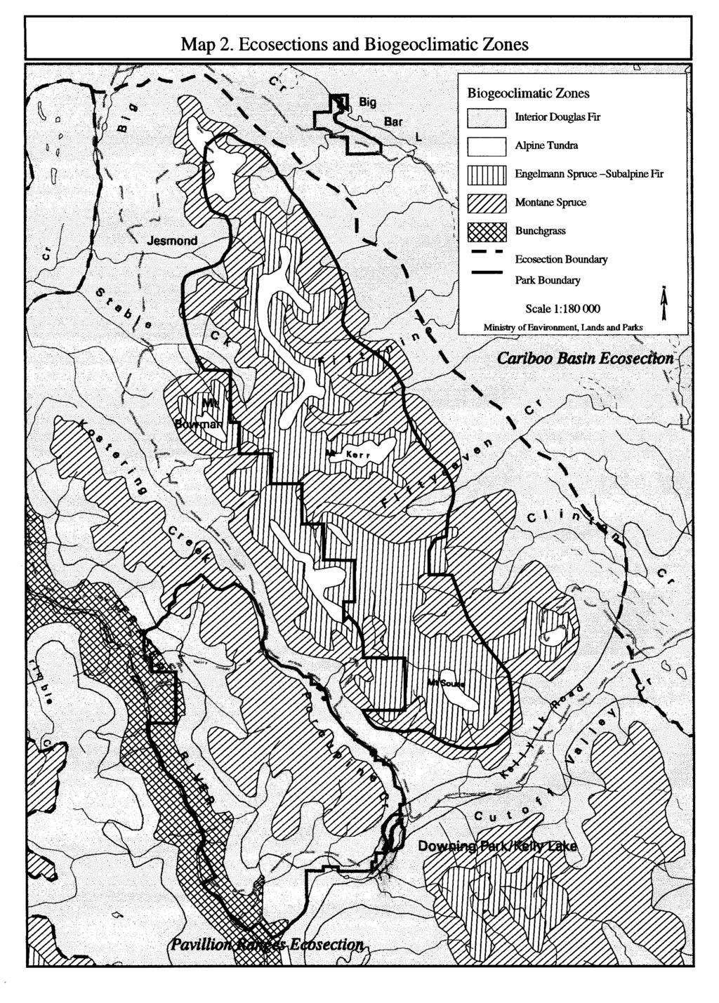
1 2.0 PARK VISION AND ROLES 2.1 Significance in the Protected Area System Marble Range and Edge Hills provincial parks protect 6.8% of the Pavillion Ranges Ecosection, which is located in the Southern Interior Ecoprovince of British Columbia. These are the largest parks in the Pavillion Ranges, with a number of smaller parks located to the south, including Cornwall, Arrowsmith and Blue Earth Lake parks in the Thompson River District. These smaller parks contribute another 2%, resulting in a total of 8.74% of the ecosection within protected areas. Map 2 shows the ecosections and biogeoclimatic zones within Marble Range and Edge Hills Parks. In addition to protecting large, representative ecosystems and backcountry opportunities, these parks encompass a number of special features. Cultural features include examples of ranching, trapping and Chinese mining history, as well as historic aboriginal settlement sites and fishing stations on the Fraser River. The Marble Range is characterized by bold castellated peaks and ridges of pale gray Upper Permian limestone. This limestone, the upper member of the Cache Creek group, extends northward from the Cornwall Hills on Upper Hat Creek to beyond Big Bar Creek. Marble Range Park is particularly noted for its karst topography, with features such as sinkholes, caves, disappearing streams and vertical shafts and vents that are unique to the interior of the province. Karst formations are not well represented in the parks system examples of other provincially significant karst formations are found in Artilish Caves and White Ridge parks on Vancouver Island. The karst topography supports rare plant communities associated with the calcareous soils that overlay the limestone bedrock geology. The parks also provide important habitat for a number of species that require large, diverse ecosystems, including mule deer and the blue listed California bighorn sheep. These parks provide outstanding backcountry opportunities for day or overnight recreationists seeking low impact experiences in close proximity to road access. Horseback riding, hiking, photography, hunting and wildlife viewing are all popular activities. There are no developed day use or overnight facilities in Marble Range or Edge Hills Parks. Other nearby parks offer overnight facilities including Big Bar Lake park with 33 campsites, Downing park with 25 campsites and Green Lake park with 121 campsites. Although Marble Range and Edge Hills Parks are located close to the community of Clinton and to Highway 97, most park visitors are from the surrounding area and utilize the area for hunting, hiking, horseback riding and wildlife viewing.
2
3 The area surrounding the parks is easily accessed by roads developed for mining, logging and settlement purposes. Increasing urbanization and population growth in the southern interior of British Columbia, have resulted in fragmentation of natural landscapes and placed a number of species on the red and blue species lists. Increases in tourist travel from Alberta and the Lower Mainland in the summer months have also created increased demand for accessible wilderness and natural environment experiences. As these trends continue, the role of these parks in protecting ecosystems and providing backcountry recreation opportunities will become increasingly important. 2.2 Roles of Marble Range and Edge Hills Provincial Parks The respective roles for Marble Range and Edge Hills Parks are described in this section and provide the general purpose of each park. Together with the vision statement, these roles help guide the management strategies and user activities within the parks. These roles are consistent with the broader provincial Protected Area Strategy Goals and with BC Parks System Goals, as described in Appendix B Roles of Marble Range Provincial Park Conservation Role Marble Range Park is representative of the subalpine and low alpine environments in the calcareous portions of the Pavilion Ranges Ecosection. It contains four biogeoclimatic zones including relatively large areas of the Engelmann Spruce- Subalpine Fir zone and smaller areas of the Alpine Tundra, Montane Spruce and Interior Douglas-fir zones. The park has a high degree of naturalness including: closed canopy old forests of spruce, lodgepole pine, whitebark pine and Douglas-fir; a variety of younger forests; extensive forest/alpine parklands; and dry meadows. Unusual dry grasslands occur on the southern slopes of the park on Mt. Soues. The forest/alpine parkland, which is a major feature of the park, is especially rich in bird species, alpine flowering plants and other wildlife. This parkland environment has high wildlife habitat and wildlife viewing values. The park is unusual for its limestone bedrock and calcareous soils. Unusual plant species are present due to this calcareous bedrock, and some plant species occur at elevations higher than their normal distribution on other types of bedrock. The park protects important habitat for California bighorn sheep, including ram and lambing areas, and important summer range for mule deer. The park includes distinctive karst topography in which the action of water on limestone bedrock over thousands of years has resulted in unusual surface and subsurface features including sinkholes, vertical shafts, caves, disappearing streams and springs, and complex underground drainage systems.
4 Recreation Role Under the provincial system goals for recreation, BC Parks has four recreation goals a) tourism travel routes; b) holiday destination; c) backcountry; and d) local and regional recreation opportunities. The focus for Marble Range Park is predominantly backcountry recreation although the park also meets the goal of providing local recreation opportunities. The Marble Range is a dominant recreation feature in the south Cariboo and offers exceptional opportunities for enjoying mountain scenery and experiencing the outdoors. Marble Range Park provides an informal network of overnight and day use trails and routes that support hiking, horseback riding and backcountry camping in a wilderness setting. The park provides opportunities for wildlife viewing and hunting Roles of Edge Hills Provincial Park Conservation Role Edge Hills Park is representative of the non-calcareous portion of the Pavilion Ranges Ecosection and contains ecosystems of the Bunchgrass, Interior Douglas-fir and Montane Spruce biogeoclimatic zones. The west slopes of the park include a unique sequence of ecosystems from dry grassland and sagebrush communities at low elevations, to old Douglas-fir forests at middle elevations, and moist spruce and lodgepole pine forests at upper elevations. The park is especially notable for its grassland and dry forest/grassland transition ecosystems which provide habitat for a rich diversity of wildlife species, possibly including several rare, endangered or threatened species. The park protects important mule deer winter range and important habitat for California bighorn sheep, including portions of a migration corridor to lambing areas. The park includes habitat for cougar, bats, grouse and many other species characteristic of dry Interior forests and forest/grassland transitions. Recreation Role The focus for Edge Hills Park in meeting provincial system goals for recreation is to provide low intensity backcountry recreation and local recreation opportunities. Edge Hills provides opportunity for low intensity wildlife viewing, photography, hunting, limited horseback riding and hiking in a backcountry setting.

5 2.2.3 Cultural Heritage Role for the Parks Marble Range and Edge Hills Parks are within the traditional territory of the aboriginal people of the Shuswap area and have a history of aboriginal occupation. Three First Nations continue to use these parks for sustenance, spiritual and cultural purposes. Within Edge Hills Park, and potentially within Marble Range Park, are a number of pit houses that date from a time of early settlement by the Shuswap people. These areas are of significant cultural and spiritual importance to aboriginal people, and may hold important archaeological interest. Mining, ranching, trapping and guiding activities have occurred in and around these parks for many years and add important historical interest and context for park visitors and local residents. Grange Mine, located just outside Edge Hills Park at the mouth of Kelly Creek, operated until the late 1940s. Evidence also exists of extensive placer and hardrock mining in the form of numerous shafts and adits. Miners cabins existed below Pear Lake. There is a history of Chinese people working placer and hardrock claims extensively in this area. Plate 2: Lower grassland slopes of Edge Hills Park
6 2.3 Vision Statement The vision statement for Marble Range and Edge Hills Parks describes the character and use of these areas as we would expect to experience them 25 years from now (in 2023). Being clear about the long-term vision (state) guides what management objectives and strategies are adopted in the short-term (to achieve the vision). The vision assists park managers when faced with the need to respond to changing environmental conditions, growing recreational pressures or shifts in approaches to conservation management. The vision statement is also based, in part, on the conservation and recreation contributions of these park areas to the provincial Protected Areas Strategy. Vision Statement Marble Range and Edge Hills Provincial Parks are, and will continue to be known as wilderness parks. The main focus of management is the protection and maintenance of the wild, natural ecosystems, particularly those elements related to the protection of wildlife habitat and conservation of wildlife populations. These parks continue to fulfill their traditional roles as areas of local and regional, low-impact recreational use in a wilderness setting. Park users continue to cherish the wilderness experience. Marble Range and Edge Hills are small, rugged parks that provide the visitor with a sense of connectedness to the natural landscape and a feeling of discovery of a special place of beauty and tranquillity. These parks contribute to the natural history of the area. Marble Range and Edge Hills Provincial Parks are managed as complementary units that together contribute important elements of summer and winter ungulate habitat. Other important features include outstanding limestone geology and cave and vent formations that are protected from recreation impacts. Park management is integrated with the management of lands and resources on adjacent Crown lands through government planning and coordinated operational activities.
7 Achieving the Vision Natural ecosystems and ecological integrity are maintained. Riparian areas are protected from damage. Management across park boundaries is coordinated with other regulatory agencies to enhance park values and maintain aesthetic qualities. Wildlife habitat and viable wildlife populations are sustained within the parks and in the vicinity of the parks, particularly with respect to California bighorn sheep and mule deer. Park management reflects the historic recreational pursuits of local people and the general public, particularly hiking, horseback riding, wildlife viewing, hunting, backpacking, and nature appreciation. Visitor numbers are managed at a level that protects the natural ecological integrity and maintains the backcountry experience. Recreation uses are non-motorized and low impact, and do not detract from the natural values, particularly the quality of wildlife habitat and use of critical ranges. Commercial facilities and permanent structures are located in appropriate areas outside of park boundaries. Commercial backcountry operations are compatible with levels of public recreation use. Aboriginal people use the park areas for subsistence, spiritual and cultural purposes. Local residents and aboriginal people participate in park management planning and operational activities.
Role of the Protected Area
 Role of the Protected Area Provincial and Regional Context Height of the Rockies and Elk Lakes provincial parks lie in southeastern British Columbia in the Rocky Mountains, about 85 km southwest of Calgary,
5.0 OUTDOOR RECREATION OPPORTUNITIES AND MANAGEMENT
 5.0 OUTDOOR RECREATION OPPORTUNITIES AND MANAGEMENT 5.1 Introduction This section describes the range of recreational activities that currently take place in Marble Range and Edge Hills Parks, as well
Fred Antoine Park. Management Plan. Final Public Review Draft
 Fred Antoine Park Management Plan Final Public Review Draft March 2016 Fred Antoine Park Management Plan Approved by: Jeff Leahy Regional Director Thompson Cariboo Region BC Parks Date Brian Bawtinheimer
The following criteria were used to identify Benchmark Areas:
 7.0 BENCHMARK AREAS The Churn Creek Protected Area offers a significant opportunity to learn more about how grassland ecosystems function. One of the key tools that will be used to monitor larger grassland
MANAGEMENT DIRECTION STATEMENT
 Lower Mainland District MAAGEMET DIRECTIO STATEMET January 2001 for Liumchen Ecological Reserve Ministry of Environment Lands and Parks BC Parks Division Table of Contents Page Introduction... 1 Purpose
SUGARBOWL-GRIZZLY DEN PROVINCIAL PARK AND SUGARBOWL-GRIZZLY DEN PROTECTED AREA Purpose Statement and Zoning Plan
 SUGARBOWL-GRIZZLY DEN PROVINCIAL PARK AND SUGARBOWL-GRIZZLY DEN PROTECTED AREA Purpose Statement and Zoning Plan Located one hour east of Prince George on Highway 16, Sugarbowl-Grizzly Den Provincial Park
MANAGEMENT DIRECTION STATEMENT June, 1999
 Thompson River District MANAGEMENT DIRECTION STATEMENT June, 1999 for Clearwater River Corridor (Addition to Wells Gray Park) Ministry of Environment Lands and Parks BC Parks Division ii Table of Contents
MAIN LAKE PROVINCIAL PARK
 MAIN LAKE PROVINCIAL PARK PURPOSE STATEMENT AND ZONING PLAN March 2003 MAIN LAKE PROVINCIAL PARK Purpose Statement and Zoning Plan Primary Role The primary role of Main Lake Park is to protect a biologically
Appendix A BC Provincial Parks System Goals
 Appendix A BC Provincial Parks System Goals The British Columbia Provincial Parks System has two mandates: To conserve significant and representative natural and cultural resources To provide a wide variety
FINGER-TATUK PROVINCIAL PARK
 FINGER-TATUK PROVINCIAL PARK PURPOSE STATEMENT AND ZONING PLAN March 2003 FINGER-TATUK PROVINCIAL PARK Purpose Statement and Zoning Plan Finger-Tatuk Provincial Park is 17,151 ha in size. It includes the
Kwadacha Wilderness Provincial Park and Kwadacha Addition (Kwadacha Recreation Area) Purpose Statement and Zoning Plan
 Purpose Statement and Zoning Plan") Kwadacha Wilderness Provincial Park and Kwadacha Addition (Kwadacha Recreation Area) Purpose Statement and Zoning Plan Located in a remote area of the northern interior of BC, this large park straddles
Kwadacha Wilderness Provincial Park and Kwadacha Addition (Kwadacha Recreation Area) Purpose Statement and Zoning Plan Located in a remote area of the northern interior of BC, this large park straddles
Stuart River Provincial Park Purpose Statement and Zoning Plan
 Stuart River Provincial Park Purpose Statement and Zoning Plan Stuart River Provincial Park protects three-quarters of the 110 kilometer long Stuart River corridor between Stuart Lake and the Nechako River.
HOLE IN THE WALL PROVINCIAL PARK
 HOLE IN THE WALL PROVINCIAL PARK PURPOSE STATEMENT AND ZONING PLAN Peace Region 2006 Approved by: Andy Ackerman, Regional Manager Environmental Stewardship Division Peace Region Date: 2006 Nancy Wilkin
STONE MOUNTAIN PROVINCIAL PARK Purpose Statement and Zoning Plan
 1 STONE MOUNTAIN PROVINCIAL PARK Purpose Statement and Zoning Plan Stone Mountain Provincial Park is situated 140 km west of Fort Nelson at Kilometre 595 of the Alaska Highway. The 25 690 ha park is located
Fraser River Provincial Park Purpose Statement and Zoning Plan
 Fraser River Provincial Park Purpose Statement and Zoning Plan Fraser River Provincial Park is located on the west bank of the Fraser River, approximately 35 km south of Prince George. This 4,899 ha Protected
Mackinnon Esker Ecological Reserve Draft - Management Plan
 Mackinnon Esker Ecological Reserve Draft - Management Plan May 2011 Photo Credit: This document replaces the direction provided in the Carp Lake Provincial Park and Protected Area and Mackinnon Esker Ecological
Outdoor Recreation Opportunities Management
 Outdoor Recreation Opportunities Management Introduction The natural features of Height of the Rockies and Elk Lakes provincial parks provide a wide variety of outdoor recreational activities. However,
ANAGEMENT P LAN. July for Chilliwack Lake Park & Chilliwack River Ecological Reserve. Ministry of Environment, Lands and Parks BC Parks Division
 M ANAGEMENT P LAN July 2000 for Chilliwack Lake Park & Chilliwack River Ecological Reserve Ministry of Environment, Lands and Parks BC Parks Division Chilliwack Lake Provincial Park & Chilliwack River
MANAGEMENT DIRECTION STATEMENT June, 1999
 Thompson River District MANAGEMENT DIRECTION STATEMENT June, 1999 for Roche Lake Provincial Park Ministry of Environment Lands and Parks BC Parks Division Table of Contents I. Introduction A. Setting
NECHAKO CANYON PROTECTED AREA
 NECHAKO CANYON PROTECTED AREA PURPOSE STATEMENT AND ZONING PLAN March 2003 1 Nechako Canyon Protected Area Purpose Statement and Zoning Plan The Nechako Canyon Protected Area (1,246 hectares) is located
Steps in the Management Planning Process
 Steps in the Management Planning Process Developing a management plan for Kalamalka Lake Park will follow a multi-stage process. The planning process for this park is currently in the Draft Management
THUNDER HILL PROVINCIAL PARK
 THUNDER HILL PROVINCIAL PARK PURPOSE STATEMENT AND ZONING PLAN February 2003 Approved by: THUNDER HILL PROVINCIAL PARK Purpose Statement and Zoning Plan Primary Role The primary role of Thunder Hill Provincial
SHUSWAP LAKE MARINE PROVINCIAL PARK
 SHUSWAP LAKE MARINE PROVINCIAL PARK Purpose Statement and Zoning Plan The primary role of the Shuswap Lake Marine Provincial Park is to provide a system of sites for marine overnight and day use of Shuswap
ANAGEMENT. LAN November, 1996
 M ANAGEMENT P LAN November, 1996 for Paul Lake Provincial Park Ministry of Environment, Lands and Parks BC Parks Department Paul Lake Provincial Park M ANAGEMENT P LAN Prepared by BC Parks Kamloops Area
MARBLE RIVER PROVINCIAL PARK
 MARBLE RIVER PROVINCIAL PARK PURPOSE STATEMENT AND ZONING PLAN March 2003 MARBLE RIVER PROVINCIAL PARK Purpose Statement and Zoning Plan Primary Role The primary role of Marble River Park is to protect
Dragon Mountain Park. Management Plan. Public Review Draft
 Disclaimer: This draft management plan contains preliminary proposals that are subject to change and therefore may not necessarily reflect the position of the Ministry of Environment. At the conclusion
ANAGEMENT P LAN. February, for Elk Lakes and Height of the Rockies Provincial Parks. Ministry of Environment, Lands and Parks BC Parks Division
 M ANAGEMENT P LAN February, 1999 for Elk Lakes and Height of the Rockies Provincial Parks Ministry of Environment, Lands and Parks BC Parks Division Elk Lakes & Height of the Rockies Provincial Parks M
Mackinnon Esker Ecological Reserve. Management Plan
 Mackinnon Esker Ecological Reserve Management Plan March 2017 Cover Page Photo Credit: Rob Bell This document replaces the direction provided in the Carp Lake Provincial Park and Protected Area and Mackinnon
Natural and Cultural Values and Their Management...18
 Skagit Valley Provincial Park Management Plan Table of Contents Plan Highlights...4 Introduction...5 The Management Planning Process...5 Background Summary...6 Relationship to Other Land Use Planning...8
KANANASKIS COUNTRY PROVINCIAL RECREATION AREAS MANAGEMENT PLAN DRAFT TERMS OF REFERENCE - November 20, 2007
 KANANASKIS COUNTRY PROVINCIAL RECREATION AREAS MANAGEMENT PLAN DRAFT TERMS OF REFERENCE - November 20, 2007 BACKGROUND There are 42 Provincial Recreation Areas (PRAs) within Kananaskis Country located
MANAGEMENT DIRECTION STATEMENT
 Skeena District MAAGEMET DIRECTIO STATEMET August 2000 for Driftwood Extension to Babine Mountains Park Ministry of Environment Lands and Parks BC Parks Division This management direction statement was
MANAGEMENT DIRECTION STATEMENT June, 1999
 Garibaldi/Sunshine Coast District MAAGEMET DIRECTIO STATEMET June, 1999 for Homathko Estuary Provincial Park Ministry of Environment Lands and Parks BC Parks Division TABLE OF COTETS Introduction...1
MANAGEMENT DIRECTION STATEMENT October, 1999
 Thompson River District MAAGEMET DIRECTIO STATEMET October, 1999 for Harry Lake Aspen Provincial Park Ministry of Environment Lands and Parks BC Parks Division Ministry of Environment, Lands and Parks
BLANKET CREEK PROVINCIAL PARK
 BLANKET CREEK PROVINCIAL PARK PURPOSE STATEMENT AND ZONING PLAN February 2003 BLANKET CREEK PROVINCIAL PARK Purpose Statement and Zoning Plan Primary Role The primary role of Blanket Creek Park is to maintain
2009 Clearwater Area Sheep
 2009 Clearwater Area Sheep Section Authors: Chiarastella Feder and Shevenell Webb Suggested Citation: Feder, C. and S. Webb. 2009. Clearwater Area Sheep. Pages 22 25. In: N. Webb and R. Anderson. Delegated
South Chilcotin Mountains Park and Big Creek Park. Management Plan. Final Public Review Draft
 South Chilcotin Mountains Park and Big Creek Park Management Plan Final Public Review Draft March 2016 This document replaces the Big Creek Park Management Direction Statement, approved in November 1999.
Marchand Provincial Park. Management Plan
 Marchand Provincial Park Management Plan 2 Marchand Provincial Park Table of Contents 1. Introduction... 3 2. Park History... 3 3. Park Attributes... 4 3.1 Natural... 4 3.2 Recreational... 4 3.3 Additional
Victor Lake Park. Management Plan
 Victor Lake Park Management Plan November 2012 Victor Lake Park Management Plan Approved by: Jeff Leahy, Regional Director Thompson Cariboo Region BC Parks March 28, 2012 Date Brian Bawtinheimer, Executive
MANAGEMENT DIRECTION STATEMENT February 2001
 Thompson River District MAAGEMET DIRECTIO STATEMET February 2001 for Greenstone Mountain Provincial Park Ministry of Environmen Lands and Parks BC Parks Division Table of Contents Introduction... 1 Purpose
BELLHOUSE PROVINCIAL PARK
 BELLHOUSE PROVINCIAL PARK PURPOSE STATEMENT AND ZONING PLAN March 2003 1 BELLHOUSE PROVINCIAL PARK Purpose Statement and Zoning Plan Primary Role The primary role of Bellhouse Provincial Park is to protect
Bridge River Delta Park. Management Plan. Final Public Review Draft
 Bridge River Delta Park Management Plan Final Public Review Draft March 2016 Bridge River Delta Park Management Plan Approved by: Jeff Leahy Regional Director Thompson Cariboo Region BC Parks Date Brian
Dragon Mountain Park. Management Plan
 Dragon Mountain Park Management Plan December 2015 Dragon Mountain Park Management Plan Approved by: Peter Weilandt A/Regional Director Thompson Cariboo Region BC Parks December 14. 2015 Date Brian Bawtinheimer
ONE ISLAND LAKE PROVINCIAL PARK Purpose Statement and Zoning Plan
 ONE ISLAND LAKE PROVINCIAL PARK Purpose Statement and Zoning Plan Primary Role The primary role of One Island Lake Provincial Park is to provide recreational opportunities to regional and residential area
APPENDIX. Alberta Land Stewardship Act AMENDMENTS TO THE SOUTH SASKATCHEWAN REGIONAL PLAN
 APPENDIX Alberta Land Stewardship Act AMENDMENTS TO THE SOUTH SASKATCHEWAN REGIONAL PLAN 1 All references to Alberta Environment and Sustainable Resource Development, Environment and Sustainable Resource
SANTA-BOCA PROVINCIAL PARK
 SANTA-BOCA PROVINCIAL PARK PURPOSE STATEMENT AND ZONING PLAN March 2003 SANTA-BOCA PROVINCIAL PARK Purpose Statement and Zoning Plan Primary Role The primary role of Santa-Boca Park is to provide marine-based
VARGAS ISLAND PROVINCIAL PARK
 VARGAS ISLAND PROVINCIAL PARK PURPOSE STATEMENT AND ZONING PLAN February 2003 VARGAS ISLAND PROVINCIAL PARK Purpose Statement and Zoning Plan Primary Role The primary role of Vargas Island Park is to protect
2.0 Physical Characteristics
 _ 2.0 Physical Characteristics 2.1 Existing Land Use for the Project The site is comprised of approximately 114 acres bounded by Highway 101 to the north, the existing town of Los Alamos to the east, State
MANAGEMENT DIRECTION STATEMENT November 1999
 Garibaldi/Sunshine Coast District MAAGEMET DIRECTIO STATEMET ovember 1999 for Upper Lillooet Provincial Park Ministry of Environment Lands and Parks BC Parks Division UPPER LILLOOET PROVICIAL PARK APPROVALS
MILLIGAN HILLS PROVINCIAL PARK
 MILLIGAN HILLS PROVINCIAL PARK PURPOSE STATEMENT AND ZONING PLAN Peace Region 2006 Approved by: Andy Ackerman, Regional Manager Environmental Stewardship Division Peace Region Date: 2006 Nancy Wilkin Assistant
BIGHORN BACKCOUNTRY ACCESS MANAGEMENT PLAN
 BIGHORN BACKCOUNTRY ACCESS MANAGEMENT PLAN October, 2002 SPECTACULAR BY NATURE BIGHORN BACKCOUNTRY Alberta s Bighorn Backcountry offers spectacular Rocky Mountain scenery and unforgettable recreational
Wyoming Public Lands Initiative in Carbon County
 Wyoming Public Lands Initiative in Carbon County THE CARBON COUNTY WPLI ADVISORY COMMIT TEE WANTS YOUR INPUT Wilderness Study Area: A special designation that applies to lands managed to protect wilderness
MANAGEMENT DIRECTION STATEMENT
 Skeena District MAAGEMET DIRECTIO STATEMET July, 2000 for Driftwood Canyon Provincial Park Ministry of Environment Lands and Parks BC Parks Division i Table of Contents Driftwood Canyon Park Approvals
Skihist Park. Management Plan. Draft for public review
 Skihist Park Management Plan Draft for public review August 2017 This document replaces the Skihist Park Management Plan (November 1996). Skihist Park Management Plan Approved by: Jeff Leahy Regional Director
Hudson Bay Lowlands Proposed Protected Areas
 Hudson Bay Lowlands Proposed Protected Areas Hudson Bay Lowlands Proposed Protected Areas The Protected Areas Initiative has identified portions of the Hudson Bay Lowlands region that have significant
INLAND LAKE PROVINCIAL PARK
 INLAND LAKE PROVINCIAL PARK PURPOSE STATEMENT AND ZONING PLAN December 2002 INLAND LAKE PROVINCIAL PARK Purpose Statement and Zoning Plan Primary Role The primary role of Inland Lake Park is the protection
Wrinkly Face Provincial Park Purpose Statement and Zoning Plan
 Wrinkly Face Provincial Park Purpose Statement and Zoning Plan Wrinkly Face Provincial Park is located about 16 km northeast of Winfield. The park is accessed via a logging road off the Beaver Main Forest
Pillar Park. Management Plan
 Pillar Park Management Plan January 2014 Pillar Park Management Plan Approved by: Jeff Leahy Regional Director Thompson Cariboo Region BC Parks January 9, 2014 Date Brian Bawtinheimer Executive Director
Qwalímak/Upper Birkenhead Conservancy. Management Plan
 Qwalímak/Upper Birkenhead Conservancy Management Plan March 2012 Cover photo: Upper Birkenhead River Photo credit: Liz Scroggins Qwalímak/Upper Birkenhead Conservancy Management Plan Acknowledgements
Whitemouth Falls Provincial Park. Draft Management Plan
 Whitemouth Falls Provincial Park Draft Management Plan Whitemouth Falls Provincial Park Draft Management Plan Table of Contents 1. Introduction... 3 2. Park History... 3 3. Park Attributes... 4 3.1 Natural...
Yard Creek Provincial Park. Management Plan
 Yard Creek Provincial Park Management Plan Draft January 2010 Yard Creek Provincial Park Management Plan Approved by: telàlsemkin/siyam/chief Scott Benton Bill Williams Squamish Executive Director ation
OMINEACA PROVINCIAL PARK
 OMINEACA PROVINCIAL PARK AND PROTECTED AREA PURPOSE STATEMENT AND ZONING PLAN March 2003 OMINECA PROVINCIAL PARK AND PROTECTED AREA Purpose Statement and Zoning Plan Omineca Park and Omineca Protected
OPEN SPACE. The Open Space Element describes the County s goals and policies with respect to open space areas and addresses the following topics:
 PURPOSE This element addresses open spaces for: the managed production of resources, outdoor recreation, public health and safety, and the preservation of natural resources. Amador County s open space
CARMANAH WALBRAN PROVINCIAL PARK
 CARMANAH WALBRAN PROVINCIAL PARK PURPOSE STATEMENT AND ZONING PLAN September 2003 1 CARMANAH WALBRAN PROVINCIAL PARK Purpose Statement and Zoning Plan Carmanah Walbran Provincial Park is an expansion of
Existing Resource Information
 Botanical and Wildlife Vegetation alliances/wildlife habitats Grasslands annual/perennial Chaparral mixed/montane/chamise-redshank Riparian montane/valley foothill riparian Sierran mixed conifer Montane
Map 1.1 Wenatchee Watershed Land Ownership
 Map 1.1 Wenatchee Watershed Land Ownership Map 1.1 Wenatchee Watershed Land Ownership The Wenatchee watershed lies in the heart of Washington state in Chelan County. Just larger than the state of Rhode
SLIM CREEK PROVINCIAL PARK
 SLIM CREEK PROVINCIAL PARK PURPOSE STATEMENT AND ZONING PLAN March 2003 1 Slim Creek Provincial Park Purpose Statement and Zoning Plan Slim Creek Provincial Park is located along Highway 16, approximately
Finn Creek Park. Management Direction Statement Amendment
 Finn Creek Park Management Direction Statement Amendment November 2013 Management Direction Statement Amendment Approved by: Jeff Leahy Regional Director, Thompson Cariboo BC Parks November 12, 2013 Date
LILLOOET LRMP CONSERVATION, RECREATION, TOURISM AND COMMUNITY. FINAL OFFER March 13, 2001
 LILLOOET LRMP CONSERVATION, RECREATION, TOURISM AND COMMUNITY I) EXECUTIVE SUMMARY FINAL OFFER March 13, 2001 This ofier has been prepared by members of the Lillooet LRMP table representing tourism, conservation,
BROUGHTON ARCHIPELAGO PROVINCIAL PARK
 BROUGHTON ARCHIPELAGO PROVINCIAL PARK PURPOSE STATEMENT AND ZONING PLAN March 2003 BROUGHTON ARCHIPELAGO PROVINCIAL PARK Purpose Statement and Zoning Plan Primary Role The primary role is to contribute
Brackendale Eagles Park Baynes Island Ecological Reserve Tantalus Park. Management Plan. February Squamish Nation
 Brackendale Eagles Park Baynes Island Ecological Reserve Tantalus Park Brackendale Eagles Park Baynes Island Ecological Reserve Tantalus Park February 2012 Squamish Nation This document replaces the direction
Clearwater Lake Provincial Park. Draft Management Plan
 Clearwater Lake Provincial Park Draft Management Plan Clearwater Lake Provincial Park Draft Management Plan Table of Contents 1. Introduction... 3 2. Park History... 4 3. Park Attributes... 4 3.1 Location/Access...4
D IRECTION S TATEMENT
 Vancouver Island Region M ANAGEMENT D IRECTION S TATEMENT September 2003 for Lower Nimpkish Provincial Park Ministry of Water, Land and Air Protection Environmental Stewardship Lower Nimpkish Provincial
Restore and implement protected status that is equivalent, or better than what was lost during the mid-1990 s
 THE ROSSLAND RANGE, OLD GLORY AREA. Executive summary. The Friends of the Rossland Range Society, on behalf of the local outdoor community, seeks to accomplish the following with respect to the Old Glory
Disclosure Document for Castle Mountain Resort Future Development
 Disclosure Document for Castle Mountain Resort Future Development September 2018 1._ Introduction Castle Mountain Resort Inc. (CMR) has completed a Master Development Plan that proposes to expand the existing
Outdoor Recreation Opportunities Management
 Outdoor Recreation Opportunities Management Introduction A major role of a management plan is to provide direction regarding the types of recreation that are appropriate, and to outline the steps that
Monkman Provincial Park. Master Plan
 Monkman Provincial Park Master Plan Table of Contents Plan Highlights...1 Section One: Introduction What is a Master Plan?...4 Relationship With Other Land Use Planning...6 How This Plan Was Prepared...7
ROBERTS CREEK PROVINCIAL PARK MASTER PLAN. November, 1981
 Ministry of Lands, Parks and Housing Parks and Outdoor Recreation Division Park Operations Branch North Vancouver, B. C. ROBERTS CREEK PROVINCIAL PARK MASTER PLAN November, 1981 Mr. G. Trachuk Director
As outlined in the Tatshenshini-Alsek Park Management Agreement, park management will:
 Management Strategy General Strategy The priority management focus for the park is to ensure that its internationally significant natural, cultural heritage and recreational values are protected and that
MANAGEMENT DIRECTION STATEMENT March 2003
 Skeena Region MAAGEMET DIRECTIO STATEMET March 2003 for Meziadin Lake Provincial Park Ministry of Water, Land and Air Protection Environmental Stewardsh Division This page left blank on purpose ii Table
KOOTENAY LAKE PROVINCIAL PARK (MIDGE CREEK SITE)
") KOOTENAY LAKE PROVINCIAL PARK (MIDGE CREEK SITE) PURPOSE STATEMENT AND ZONING PLAN February 2003 Approved by: KOOTENAY LAKE PROVINCIAL PARK (Midge Creek Site) Purpose Statement and Zoning Plan Primary
KOOTENAY LAKE PROVINCIAL PARK (MIDGE CREEK SITE) PURPOSE STATEMENT AND ZONING PLAN February 2003 Approved by: KOOTENAY LAKE PROVINCIAL PARK (Midge Creek Site) Purpose Statement and Zoning Plan Primary
MANAGEMENT DIRECTION STATEMENT November 2003
 Skeena Region MANAGEMENT DIRECTION STATEMENT November 2003 for Sutherland River Provincial Park and Sutherland River Protected Area Ministry of Water, Land and Air Protection Environmental Stewardship
Appendix A Chilko Lake Protected Area Intent and Management Principles
 Appendix A Chilko Lake Protected Area Intent and Management Principles 95 Intent and Management Principles (as prescribed by the Chilko Lake Study Team) General Intent This proposed Chilko Lake Protected
South Chilcotin Mountains Park and Big Creek Park. Management Plan. Public Review Draft
 South Chilcotin Mountains Park and Big Creek Park Management Plan Public Review Draft February 2014 This document replaces the Big Creek Park Management Direction Statement, approved in November 1999.
Bat Cave Canyon Ranch 2,920 acres Jeff Davis County, Texas
 Bat Cave Canyon Ranch 2,920 acres Jeff Davis County, Texas James King, Agent Office 432.426.2024 Cell 432.386.2821 James@KingLandWater.com Bat Cave Canyon Ranch 2,920 acres Jeff Davis County, Texas James
26 Utah s Patchwork Parkway SCENIC BYWAY CORRIDOR MANAGEMENT PLAN (SR 143)
") Natural Natural Quality applies to those features in the visual environment that are in a relatively undisturbed state. These features predate the arrival of human populations and may include geological
Natural Natural Quality applies to those features in the visual environment that are in a relatively undisturbed state. These features predate the arrival of human populations and may include geological
PROUDLY BRINGING YOU CANADA AT ITS BEST. Management Planning Program NEWSLETTER #1 OCTOBER, 2000
 PROUDLY BRINGING YOU CANADA AT ITS BEST VUNTUT NATIONAL PARK Management Planning Program NEWSLETTER #1 OCTOBER, 2000 INTRODUCTION This newsletter launches the development of the first management plan for
Chapter 2: El Dorado County Characteristics and Demographics
 Chapter 2: El Dorado County Characteristics and Demographics 2.1 Geographic Area and Demographics El Dorado County comprises 1,805 square miles with over half of the area in the Eldorado National Forest
MANAGEMENT DIRECTION STATEMENT March 2003
 Skeena Region MAAGEMET DIRECTIO STATEMET March 2003 for Great Glacier Provincial Park Ministry of Water, Land an Air Protection Environmental Stewardship Division ii This management direction statement
FINAL TESTIMONY 1 COMMITTEE ON RESOURCES UNITED STATES HOUSE OF REPRESENTATIVES. July 13, 2005 CONCERNING. Motorized Recreational Use of Federal Lands
 FINAL TESTIMONY 1 STATEMENT OF DALE BOSWORTH CHIEF Of the FOREST SERVICE UNITED STATES DEPARTMENT OF AGRICULTURE Before the SUBCOMMITTEE ON FORESTS AND FOREST HEALTH And the SUBCOMMITTEE ON NATIONAL PARKS,
SPECTACLE LAKE PROVINCIAL PARK PURPOSE STATEMENT AND ZONING PLAN
 SPECTACLE LAKE PROVINCIAL PARK PURPOSE STATEMENT AND ZONING PLAN August 2003 1 SPECTACLE LAKE PROVINCIAL PARK Purpose Statement and Zoning Plan Primary Role The primary role of Spectacle Lake Park is to
Morgan Estates. Lassen County, CA. Proudly Offered By
 Morgan Estates Lassen County, CA Proudly Offered By 707 Merchant Street, Suite 100, Vacaville, Ca 95688 (707) 455-4444 Office (707) 455-0455 Fax info@caoutdoorproperties.com Introduction Looking North
Muscovite Lakes Provincial Park Purpose Statement and Zoning Plan
 Muscovite Lakes Provincial Park Purpose Statement and Zoning Plan Muscovite Lakes Provincial Park is a 5,708-hectare park located on the western shore of Williston Reservoir, approximately 135 kilometres
April 10, Mark Stiles San Juan Public Lands Center Manager 15 Burnett Court Durango, CO Dear Mark,
 Mark Stiles San Juan Public Lands Center Manager 15 Burnett Court Durango, CO 81301 Dear Mark, We are pleased to offer the following comments on the draft San Juan Public Lands Center management plans
Special Recreation Management Areas Extensive Recreation Management Areas Public Lands Not Designated as Recreation Management Areas
 From the Proposed RMP: Special Recreation Management Areas SRMAs are an administrative unit where the existing or proposed recreation opportunities and recreation setting characteristics are recognized
APPENDIX G. The WAP Conservation Landscape and Focal Areas
 APPENDIX G The WAP Conservation Landscape and Focal Areas Focal areas were identified as discrete landscape units using the natural basin and range geography of the Nevada landscape. These units were prioritized
BURGES JAMES GADSDEN PROVINCIAL PARK PURPOSE STATEMENT AND ZONING PLAN
 BURGES JAMES GADSDEN PROVINCIAL PARK PURPOSE STATEMENT AND ZONING PLAN February 2003 BURGES JAMES GADSDEN PROVINCIAL PARK Purpose Statement and Zoning Plan Primary Role The primary role of Burges James
Seager Wheeler Lake. Representative Area. -- Concept Management Plan --
 Seager Wheeler Lake Representative Area -- Concept Management Plan -- Saskatchewan Environment and Resource Management January, 1999 Saskatchewan s Representative Areas Network Program The Government of
Wallace Lake Provincial Park. Management Plan
 Wallace Lake Provincial Park Management Plan 2 Wallace Lake Provincial Park Table of Contents 1. Introduction... 3 2. Park History... 3 3. Park Attributes... 4 3.1 Natural... 4 3.2 Recreational... 4 4.
Ontario s Approach to Wilderness: A Policy May 1997 (Version 1.0)
") Ontario s Approach to Wilderness: A Policy May 1997 (Version 1.0) 1.0. Introduction Wilderness is important to Ontarians, important to the sustained, healthy functioning of Ontario s ecosystems. The Ministry
Ontario s Approach to Wilderness: A Policy May 1997 (Version 1.0) 1.0. Introduction Wilderness is important to Ontarians, important to the sustained, healthy functioning of Ontario s ecosystems. The Ministry
Pinawa Provincial Park. Draft Management Plan
 Pinawa Provincial Park Draft Management Plan Pinawa Provincial Park Draft Management Plan Table of Contents 1. Introduction... 3 2. Park History... 3 3. Park Attributes... 4 3.1 Natural... 4 3.2 Recreational...