Kicking the Alpine Plants Out Mountain Goat Wallows In Mount Peale Research Natural Area (La Sal Mountains, Utah)
|
|
|
- Cory Holt
- 6 years ago
- Views:
Transcription

1 Kicking the Alpine Plants Out Mountain Goat Wallows In Mount Peale Research Natural Area (La Sal Mountains, Utah) Marc Coles-Ritchie, Grand Canyon Trust November 21, 2017 Mountain goats are digging up alpine plants and kicking them out of the La Sal Mountains, a spectacular and rare alpine ecosystem high above the red-rock canyons of southeastern Utah. In 2013 & 2014 the Utah Division of Wildlife Resources introduced 35 non-native mountain goats to these mountains. The population of goats has since doubled to more than 70, and these animals are causing significant damage to the soil and alpine plants in the Mount Peale Research Natural Area, which, by Forest Service regulations for Research Natural Areas (RNAs), is to remain in a virgin or unmodified condition. Wallows are an obvious, significant impact caused by mountain goats. Wallows are where goats have removed all plants and dug into the soil in order to roll in loose dirt, giving themselves dust baths. These wallows cause losses of alpine plants and erosion of fragile alpine soil in this high elevation setting where wind and water are forceful and the growing season short. The locations of wallows observed within the Mount Peale RNA by the Grand Canyon Trust during numerous field trips in 2017 are shown in Fig. 1. The following pages include more information about the impacts of goat wallows, as well as georeferenced photos of numerous wallows we observed in the Mount Peale RNA. A separate, larger report presents results of our 2017 monitoring of mountain goat impacts and changes at 45 Mount Peale RNA sites first assessed by Wild Utah Project in Fig. 1. Map of goat wallows observed in the Mount Peale Research Natural Area, in the La Sal Mountains of southeast Utah in
.")
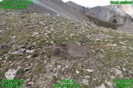
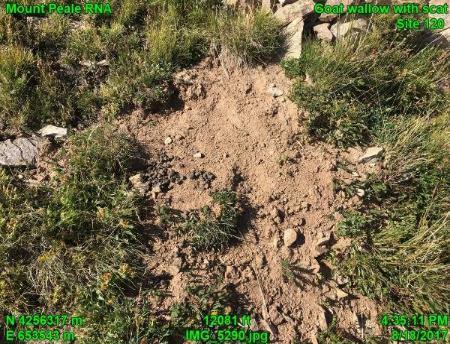
2 Background Over the objection of the Forest Service, mountain goats were transported by the Utah State Division of Wildlife Resources (UDWR) from the Tushar Range to a patch of State land on a south slope of La Sal Mountains in 2013 and The goats soon moved up to the high elevation alpine area, their preferred habitat, which includes the Mount Peale Research Natural Area (RNA). RNAs, notes the Forest Service, are permanently protected and maintained in natural conditions, for the purposes of conserving biological diversity, conducting nonmanipulative research and monitoring, and fostering education (Forest Service RNA web page). Fig. 2. Goats in the Mount Peale RNA of the La Sal Mountains (photo by Marc Coles-Ritchie, August 18, 2107). The 2,380-acre Mount Peale RNA was designated in 1988 and ranges in elevation from 10,450 feet up to the rugged peak of Mount Peale at 12,721 feet). It is one of a very few alpine areas in southern Utah and the Colorado Plateau. Many uncommon and endemic plant species live in this RNA where the management emphasis is on research and protection of pristine conditions and biological diversity ( Forest Service rare plants web page). Exotic mountain goat occupation of the Mount Peale RNA conflicts with the Forest Service requirement that RNAs be maintained in a virgin or unmodified condition (36 C.F.R ). Mountain Goat Wallows Wallows are created where mountain goats remove the alpine vegetation (grasses, sedges, wildflowers, mosses, and lichens) as they dig into the soil. We observed some wallows with much loose soil; goats return to such wallows to roll and kick dirt onto themselves (Fig 3). In other cases it appears that the loose soil has been eroded away, and what remains is a depression of compacted bare soil that is ringed by sheared turf. Goat wallows were observed throughout the Mount Peale RNA, generally at elevations of 11,500 to 12,000 feet on the ridges and saddles below peaks. Those low-gradient settings have vegetation that goats can graze and soil that goats can dig to create wallows. We also observed wallows, or possibly bedding sites, on somewhat steeper slopes where there is soil that can be dug into, but not on the steep talus slopes. The wallows usually were surrounded by numerous additional impacts from mountain goats (photos in Appendices A and B), including: Damage to plants from grazing, trampling and digging Hoof-sheared alpine turf and uprooted plants Goat droppings and fur Bare ground, where soil has been eroded Trails 2

3 The creation and use of wallows by mountain goats results in much bare ground and loose soil that is highly susceptible to erosion from wind and water. Soil loss associated with goat wallows has been observed in other places where mountain goats have been introduced, including Yellowstone National Park (Houston et al. 1994) and Olympic National Park (National Park Service 2017). Fig. 3. Goat in wallow, kicking dirt onto itself. The dashed line-arrow points to the enlarged image of the goat kicking up dirt (photo by Marc Coles-Ritchie). Alpine plants are significantly impacted by the wallowing of goats. In Olympic National Park, it was determined that Wallowing by mountain goats has impacted plant species within the park as a result of soil disturbance and subsequent creation of mineral substrates for colonization by disturbance-oriented plant species (National Park Service 2017). Additionally, the Park Service noted that mountain goats affected and killed individual rare plants by grazing, wallowing, and trampling, but our preliminary studies could not determine trends in rare plant populations subjected to goat herbivory (National Park Service 2017). In the La Sal Mountains goats are eating and kicking up sensitive plants, including the endemic La Sal daisy (Erigeron mancus) which only grows in the La Sal Mountains. Other sensitive plants that goat wallows are damaging, based on our observations, are Baker's alpineparsley (Oreoxis bakeri), dwarf mountain ragwort (Senecio fremontii), spotted saxifrage (Saxifraga bronchialis) and sweetflower rockjasmine (Androsace chamaejasme). With increases in goat numbers in this alpine area (the UDWR goal is 200 mountain goats), the number of wallows will increase, which will lead to more loss of alpine plants and increased bare soil. While wallows are a highly visible disturbance caused by mountain goats, additional types of goat disturbance are summarized in Appendices A and B and are described in the full report of Trust 2017 field work in the Mount Peale RNA. 3


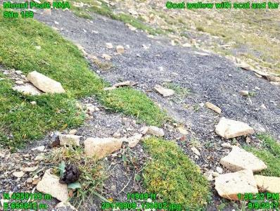
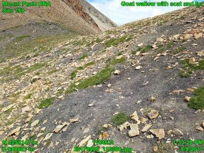
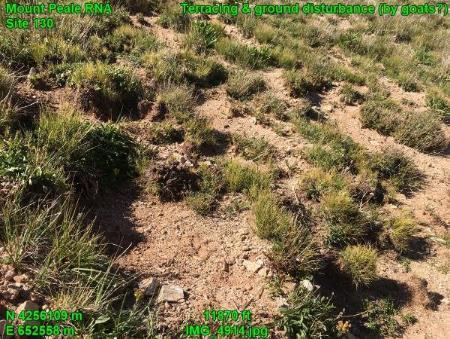
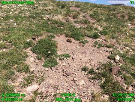
4 Mountain goat wallows are a significant modification of the Mount Peale RNA, which is intended to be a natural area, and to provide reference conditions for the rare alpine ecosystems of the Colorado Plateau. Photographs of Wallows Below are photographs of wallows that mountain goats have created in the Mount Peale Research Natural Area. These photos were taken in 2017 by the Grand Canyon Trust (Marc Coles-Ritchie and volunteers). There are certainly more wallows than those shown; these are just those we observed incidental to our 2017 alpine field work. The photos below are presented in order from north to south within Mount Peale Research Natural Area. Fig. 4. Fig. 5. Fig. 6. Fig. 7. Fig. 8. Fig. 9. 4


5 Fig. 10. Fig. 11. Fig. 12. Fig. 13. Fig. 14. Fig


6 Fig. 16. Fig. 17. Fig. 18. Fig. 19. Fig. 20. Fig


7 Fig. 22. Fig. 23. Fig. 24. Fig


8 Fig. 26. Fig. 27. Fig. 28. Fig. 29. Fig
9 Table 1. Goat wallow locations (UTM coordinates, NAD83) in the La Sal Mountains for the photos presented above. Wallow photos listed in this table are presented in order from north to south. Figure (shown above) File Name Elevation (feet) Northing (NAD83) Easting (NAD83) 4 IMG_7237_tag.JPG 12, m m 5 IMG_7238_tag.JPG 12, m m 6 IMG_7170_tag.JPG 11, m m 7 IMG_7171_tag.JPG 11, m m 8 IMG_7172_tag.JPG 11, m m 9 IMG_7173_tag.JPG 11, m m 10 IMG_7174_tag.JPG 11, m m 11 IMG_7153_tag.JPG 11, m m 12 IMG_7152_tag.JPG 11, m m _133502_tag.jpg 11, m m _133300_tag.jpg 11, m m 15 IMG_6248_tag.JPG 11, m m 16 IMG_5210_tag.jpg 12, m m 17 IMG_5262_tag.jpg 12, m m 18 IMG_5288_tag.jpg 12, m m 19 IMG_5290_tag.jpg 12, m m 20 IMG_5117_tag.jpg 11, m m 21 IMG_5112_tag.jpg 11, m m 22 IMG_4663_tag.JPG 11, m m 23 IMG_5093_tag.jpg 11, m m _165333_tag.jpg 11, m m _165452_tag.jpg 11, m m 26 IMG_4914_tag.jpg 11, m m 27 IMG_5091_tag.jpg 11, m m 28 IMG_5048_tag.jpg 11, m m 29 IMG_5037_tag.jpg 11, m m 30 IMG_5883_tag.JPG 11, m m 9
10 References Department of Interior, National Park Service Draft Mountain Goat Management Plan / Environmental Impact Statement. tid=77644 Houston, Douglas B., E. G. Schreiner, B. B. Moorhead Mountain Goats in Olympic National Park: Biology and Management of an Introduced Species. National Park Service, Olympic National Park, 600 E. Park Avenue, Port Angeles, Washington 98362, Scientific Monograph NPS/NROLYM/NRSM-94/25 United States Department of the Interior National Park Service. U.S. Forest Service RNA website. U.S. Forest Service Rare Plants website. html 10


 and ground disturbance.")
11 Appendix A. Various impacts from mountain goats in the Mount Peale Research Natural Area. Figure A1. Mountain goat scat, ground disturbance and grazed alpine plants. Figure A2. Mountain goat-sheared alpine turf and ground disturbance. Figure A3. Trampled and grazed plants in area with endemic La Sal daisy (yellow flowers). Figure A4. Mountain goat scat, ground disturbance and sheared alpine turf. Figure A5. Mountain goat fur (white cotton-like material caught in plants) and ground disturbance. Figure A6. Uprooted plants and ground disturbance, presumably by mountain goats. 11


 in bloom (yellow flowers in left")
. Figure B2.")
 and surrounded by mountain goat scat and ground disturbance (right")
12 Appendix B. Endemic and sensitive plants of the La Sal Mountain alpine area and mountain goat impacts. Endemic plants are only found in a certain geographical area, in this case the La Sal Mountains, and nowhere else in the world. A sensitive plant is a designation by the US Forest Service, Region 4 in this case, for plants whose population viability is of concern. Figure B1. The endemic La Sal daisy (Erigeron mancus) in bloom (yellow flowers in left photo) and surrounded by ground disturbance from mountain goats presumably (right photo). Figure B2. Baker's alpineparsley (Oreoxis bakeri) in bloom (yellow flowers in left photo) and surrounded by mountain goat scat and ground disturbance (right photo). La Sal daisy (tan, senesced flowers) is also present in right photo. Figure B34. Sweetflower rockjasmine (Androsace chamaejasme) in bloom (left photo) and surrounded by ground disturbance by mountain goats (right photo). 12
MOUNTAIN GOAT HERD UNIT MANAGEMENT PLAN Wildlife Management Unit #13 La Sal Mountains June 2013
 1 MOUNTAIN GOAT HERD UNIT MANAGEMENT PLAN Wildlife Management Unit #13 La Sal Mountains June 2013 BOUNDARY DESCRIPTION Grand and San Juan counties - Boundary begins at the junction of I-70 and the Green
Appendix 1: Best Management Practices For Hang Gliding and Paragliding in Jasper National Parks
 Appendix 1: Best Management Practices For Hang Gliding and Paragliding in Jasper National Parks Name of Best Management Practice Best Management Practices for Hang Gliding and Paragliding in Jasper National
Role of the Protected Area
 Role of the Protected Area Provincial and Regional Context Height of the Rockies and Elk Lakes provincial parks lie in southeastern British Columbia in the Rocky Mountains, about 85 km southwest of Calgary,
The following criteria were used to identify Benchmark Areas:
 7.0 BENCHMARK AREAS The Churn Creek Protected Area offers a significant opportunity to learn more about how grassland ecosystems function. One of the key tools that will be used to monitor larger grassland
IMPORTANT PLANT AREA NOMINATION FORM MONTANA. Nominated Site Name: South Pryor Mountains Important Plant Area (IPA)
") IMPORTANT PLANT AREA NOMINATION FORM MONTANA Nominated Site Name: South Pryor Mountains Important Plant Area (IPA) General Location: The South Pryor Mountains IPA is located between the Bighorn River on
IMPORTANT PLANT AREA NOMINATION FORM MONTANA Nominated Site Name: South Pryor Mountains Important Plant Area (IPA) General Location: The South Pryor Mountains IPA is located between the Bighorn River on
Managing Informal Trail Impacts. Jeff Marion, Unit Leader/Scientist Virginia Tech Field Unit, USGS, Patuxent WRC
 Managing Informal Trail Impacts Jeff Marion, Unit Leader/Scientist Virginia Tech Field Unit, USGS, Patuxent WRC jmarion@vt.edu, 540-231-6603 Presentation Objectives Informal Trail Management!! Decision
You can learn more about the trail camera project and help identify animals at WildCam Gorongosa (
 INTRODUCTION Gorongosa National Park is a 1,570-square-mile protected area in Mozambique. After several decades of war devastated Gorongosa s wildlife populations, park scientists and conservation managers
Birch Point Provincial Park. Management Plan
 Birch Point Provincial Park Management Plan 2 Birch Point Provincial Park Table of Contents 1. Introduction... 3 2. Park History... 3 3. Park Attributes... 4 3.1 Natural... 4 3.2 Recreational... 4 4. Park
STONE MOUNTAIN PROVINCIAL PARK Purpose Statement and Zoning Plan
 1 STONE MOUNTAIN PROVINCIAL PARK Purpose Statement and Zoning Plan Stone Mountain Provincial Park is situated 140 km west of Fort Nelson at Kilometre 595 of the Alaska Highway. The 25 690 ha park is located
Decision Memo for Desolation Trail: Mill D to Desolation Lake Trail Relocation
 for Salt Lake County, Utah Uinta-Wasatch-Cache National Forest Salt Lake Ranger District 1. Background The present location of the Desolation Trail (#1159) between Mill D and Desolation Lake follows old
South Colony Basin Recreation Fee Proposal
 South Colony Basin Recreation Fee Proposal Purpose and Need for Collecting Fees in South Colony Basin: Forest Service appropriated funds have not been sufficient to maintain current recreational services
Theme: Predominately natural/natural appearing; rustic improvements to protect resources. Size*: 2,500 + acres Infrastructure**:
 Recreation Opportunity Spectrum (ROS) Classes The Recreation Opportunity Spectrum (ROS) provides a way to describe the variations in the degree of isolation from the sounds and influences of people, and
Specification for Grip blocking using Peat Dams
 Technical Guidance Note 1 Specification for Grip blocking using Peat Dams 1. Introduction Moorland drains (grips) have been dug across much of the Yorkshire upland peatlands. Many of these grips have become
Priority Species, Communities, Ecosystems, and Threats
 Priority Species, Communities, Ecosystems, and Threats East Gippsland Regional Catchment Strategy 2015/2016 1.0 Objective This document aims to assist in the preparation of project applications for 2015-2016
Daisy Dean Trail 628/619 ATV Trail Construction
 Background and Purpose and Need The Daisy Dean ATV Trail Construction Project is located in the Little Belt Mountains, Musselshell Ranger District, Lewis and Clark National Forest approximately 32 miles
Wicklow Mountains Path Survey
 Wicklow Mountains Path Survey Glenmacnass Tonelagee Start to Finish: O 114 030 to O 085 016 Altitude (lowest highest): 370m 817m Weather: Sunny day, hot Access: Military Road, Glenmacnass Surveyed by:
FINAL TESTIMONY 1 COMMITTEE ON RESOURCES UNITED STATES HOUSE OF REPRESENTATIVES. July 13, 2005 CONCERNING. Motorized Recreational Use of Federal Lands
 FINAL TESTIMONY 1 STATEMENT OF DALE BOSWORTH CHIEF Of the FOREST SERVICE UNITED STATES DEPARTMENT OF AGRICULTURE Before the SUBCOMMITTEE ON FORESTS AND FOREST HEALTH And the SUBCOMMITTEE ON NATIONAL PARKS,
2.0 PARK VISION AND ROLES
 2.0 PARK VISION AND ROLES 2.1 Significance in the Protected Area System Marble Range and Edge Hills provincial parks protect 6.8% of the Pavillion Ranges Ecosection, which is located in the Southern Interior
Connie Rudd Superintendent, Black Canyon of the Gunnison National Park
 National Park Service U.S. Department of the Interior Black Canyon of the Gunnison National Park and Curecanti National Recreation Area Information Brochure #1 Wilderness and Backcountry Management Plan
Central Cascades Wilderness Strategies Project
 Central Cascades Wilderness Strategies Project Wilderness is Unique What makes designated Wilderness different from other national forest lands? Wilderness Act of 1964 to assure that an increasing population
Rare Coastal Sand Ecosystems
 of the Boundary Bay Wildlife Management Area The sand in Beach Grove supports unique ecosystems not commonly found in BC. The plants and animals found here are well adapted to their environment of ever-shifting
Chapter 8: Colorado Plateau State Highway 141, Dove Creek to Naturita
 State Highway 141 Dove Creek to (61 miles) Summary: Highway 141 heads north from US Highway 491 about two miles northwest of the town of Dove Creek. Initially, the highway runs through gently rolling farming
County of Riverside - PSEC Project General Habitat Assessment Appendix A
 County of Riverside - PSEC Project General Habitat Assessment Appendix A Lake Elsinore Lake Elsinore The Lake Elsinore study area is located in the hills directly adjacent to Lake Elsinore, in the City
ANAGEMENT. LAN November, 1996
 M ANAGEMENT P LAN November, 1996 for Paul Lake Provincial Park Ministry of Environment, Lands and Parks BC Parks Department Paul Lake Provincial Park M ANAGEMENT P LAN Prepared by BC Parks Kamloops Area
As outlined in the Tatshenshini-Alsek Park Management Agreement, park management will:
 Management Strategy General Strategy The priority management focus for the park is to ensure that its internationally significant natural, cultural heritage and recreational values are protected and that
A GIS Analysis of Probable High Recreation Use Areas in Three Sisters Wilderness Deschutes and Willamette National Forests
 Lindsey Kiesz Geo 565 Term Project 3/15/2010 A GIS Analysis of Probable High Recreation Use Areas in Three Sisters Wilderness Deschutes and Willamette National Forests Introduction The Three Sisters Wilderness
Summary of prescribed fires in Prince Albert National Park 2015
 Summary of prescribed fires in Prince Albert National Park 2015 Prince Albert National Park conducted four controlled fires in spring 2015, plus an additional fire in October. Fuel Management for Hazard
BACKGROUND DECISION. Decision Memo Page 1 of 6
 DECISION MEMO DEVIL S ELBOW BY-PASS, BOUNDARY TRAIL NO.1 U.S. FOREST SERVICE T9N, R7E, SECTION 9 RANGE 5E COWLITZ COUNTY WA MOUNT ST. HELENS NATIONAL VOLCANIC MONUMENT, GIFFORD PINCHOT NATIONAL FOREST
A COMPARISON OF SURFACE IMPACT BY HIKING AND HORSEBACK RIDING ON FOUR TRAIL SURFACES IN GREAT SMOKY MOUNTAINS NATIONAL PARK
 A COMPARISON OF SURFACE IMPACT BY HIKING AND HORSEBACK RIDING ON FOUR TRAIL SURFACES IN GREAT SMOKY MOUNTAINS NATIONAL PARK Paul Whittaker Susan Brat ton U.S. Department of the Interior National Park Service,
Forest: Manti-La Sal Allotment: Brumley Ridge District: Moab-Monticello Pasture: Mill Creek
 Forest: Manti-La Sal Allotment: Brumley Ridge District: Moab-Monticello Pasture: Mill Creek Oowah Bench Exclosure constructed June 6, 2012 Transects read August 31, 2012 August 13, 2016 Exclosure NE corner:
MANAGEMENT DIRECTION STATEMENT June, 1999
 Thompson River District MANAGEMENT DIRECTION STATEMENT June, 1999 for Roche Lake Provincial Park Ministry of Environment Lands and Parks BC Parks Division Table of Contents I. Introduction A. Setting
Photopoint Monitoring in the Adirondack Alpine Zone
 Photopoint Monitoring in the Adirondack Alpine Zone Julia Goren (PI) and Seth Jones Adirondack High Peaks Summit Steward Program Adirondack Mountain Club summit@adk.org PO Box 867, Lake Placid, NY 12946
MANAGEMENT DIRECTION STATEMENT March 2003
 Skeena Region MAAGEMET DIRECTIO STATEMET March 2003 for Lava Forks Provincial Park Ministry of Water, Land and Air Protection Environmental Stewardshi Division This management direction statement was
Potomac Gorge. Resource Booklet. A Natural Monument in the Shadow of National Monuments. Bridging the Watershed. Potomac Gorge 75
 Potomac Gorge Potomac Gorge A Natural Monument in the Shadow of National Monuments Resource Booklet Bridging the Watershed An outreach program of the Alice Ferguson Foundation in partnership with the National
Kit Carson-Challenger Ridge Trail Project
 Kit Carson-Challenger Ridge Trail Project Project Accomplishments Report-USFS December 15, 2015 Photo courtesy of Justin Peterson 815 South 25 th Street, Suite 101 Colorado Springs, CO 80904 Dedicated
Mackinnon Esker Ecological Reserve Draft - Management Plan
 Mackinnon Esker Ecological Reserve Draft - Management Plan May 2011 Photo Credit: This document replaces the direction provided in the Carp Lake Provincial Park and Protected Area and Mackinnon Esker Ecological
USDA Trails Strategy WRI: ENGLISH PEAK SURVEY. Theodore Mendoza San Diego State University June 6 th 2016 August 18 th Advisor: Sam Commarto
 WRI: ENGLISH PEAK SURVEY Theodore Mendoza San Diego State University June 6 th 2016 August 18 th 2016 Advisor: Sam Commarto Klamath National Forest Submitted: March 21, 2017 Table of Contents Acknowledgements
Kit Carson-Challenger Ridge Trail Project Annual Performance Report-2014 October 22, 2014
 1 Kit Carson-Challenger Ridge Trail Project Annual Performance Report-2014 October 22, 2014 Willow Lake and Kit Carson Peak 2 SUMMARY The Rocky Mountain Field Institute began Phase 1 of a multi-phase,
Colorado Parks and Wildlife Commission July 10, Raquel Wertsbaugh, CNAP Coordinator
 Colorado Natural Areas Program Logan Wash Mine Designation Colorado Parks and Wildlife Commission July 10, 2014 Raquel Wertsbaugh, CNAP Coordinator raquel.wertsbaugh@state.co.us Colorado Natural Areas
Order of the Minister of Environment #39, August 22, 2011 Tbilisi
 Registration Code 360050000.22.023.016080 Order of the Minister of Environment #39, August 22, 2011 Tbilisi On preparatory stages and procedure of the methodology for Elaborating structure, content and
Draft LAW. ON SOME AMENDAMENTS IN THE LAW No.9587, DATED ON THE PROTECTION OF BIODIVERSITY AS AMENDED. Draft 2. Version 1.
 Technical Assistance for Strengthening the Capacity of the Ministry of Environment, Forests and Water Administration in Albania for Law Drafting and Enforcement of National Environmental Legislation A
Brador hills biodiversity reserve
 Brador hills biodiversity reserve September 2003 1. Plan and description 1.1. Geographic location, boundaries and dimensions The plan of the proposed Brador hills biodiversity reserve and its location
26 Utah s Patchwork Parkway SCENIC BYWAY CORRIDOR MANAGEMENT PLAN (SR 143)
") Natural Natural Quality applies to those features in the visual environment that are in a relatively undisturbed state. These features predate the arrival of human populations and may include geological
Natural Natural Quality applies to those features in the visual environment that are in a relatively undisturbed state. These features predate the arrival of human populations and may include geological
PROPOSED ACTION South 3000 East Salt Lake City, UT United States Department of Agriculture
 United States Department of Agriculture Forest Service Uinta-Wasatch-Cache National Forest Salt Lake Ranger District 6944 South 3000 East Salt Lake City, UT 84121 801-733-2660 File Code: 1950/2300 Date:
TRAVEL WITH CHRIS BROWN
 TRAVEL WITH CHRIS BROWN ARKABA STATION In South Australia's magnificent Flinders Ranges, one eco tourism company is doing their bit to protect native wildlife. Arkaba Station was once a sheep station but
1.15 TONGARIRO GEOTHERMAL FIELD. List of Geothermal Sites. Te Maari Craters. Emerald Lakes. Contract Report No. 2348
 1.15 TONGARIRO GEOTHERMAL FIELD List of Geothermal Sites TGV01 TGV02 TGV03 TGV04 Te Maari Craters Ketetahi Emerald Lakes Red Crater 2011 452 TGV01 Te Maari Craters 0508 WILDNZ www.wildlands.co.nz ± ± 0
Keeping Wilderness Wild: Increasing Effectiveness With Limited Resources
 Keeping Wilderness Wild: Increasing Effectiveness With Limited Resources Linda Merigliano Bryan Smith Abstract Wilderness managers are forced to make increasingly difficult decisions about where to focus
Please accept the following comments on behalf of Wild Virginia the proposed Back Draft Timber Sale Project.
 P.O. Box 1065 Charlottesville, VA 22902 (434) 971-1553 www.wildvirginia.org August 29, 2008 Elwood Burge, District Ranger North River Ranger District Back Draft Scoping Comments 401 Oakwood Drive Harrisonburg,
Route #2) Mt. Massive - Southwest Slopes
 Mt. Massive - Southwest Slopes") Route #2) Mt. Massive - Southwest Slopes Difficulty: Class 2 Ski: Advanced, D6 / R2 / III Exposure: Summit Elevation: Trailhead Elevation: Elevation Gain: Round-trip Length: Trailhead: County Sheriff:
Route #2) Mt. Massive - Southwest Slopes Difficulty: Class 2 Ski: Advanced, D6 / R2 / III Exposure: Summit Elevation: Trailhead Elevation: Elevation Gain: Round-trip Length: Trailhead: County Sheriff:
Wilderness Areas Designated by the White Pine County bill
 Wilderness Areas Designated by the White Pine County bill SEC. 321. SHORT TITLE. This subtitle may be cited as the `Pam White Wilderness Act of 2006'. SEC. 322. FINDINGS. Congress finds that-- The White
Skyline Drive Hogback Canon City
 Skyline Drive Hogback Canon City Direction to trailhead: From US 50, turn north onto 15th Street. At the traffic circle, continue north on 15th Street until it dead ends at Washington Street (about 1.5
Table 1: Santiago Peak Communication Site. Latitude 1 Longitude 1 Elev 2 Address T/R/S 3 APN 4 USGS Quadrangle
 County of Riverside Public Safety Enterprise Communication Project Appendix A: Candidate Site Descriptions Overview The site is located in the Cleveland National Forest (CNF) at an existing communication
ANAGEMENT P LAN. February, for Elk Lakes and Height of the Rockies Provincial Parks. Ministry of Environment, Lands and Parks BC Parks Division
 M ANAGEMENT P LAN February, 1999 for Elk Lakes and Height of the Rockies Provincial Parks Ministry of Environment, Lands and Parks BC Parks Division Elk Lakes & Height of the Rockies Provincial Parks M
County of Riverside - PSEC Project General Habitat Assessment Appendix A
 County of Riverside - PSEC Project General Habitat Assessment Appendix A Glen Avon Glen Avon The Glen Avon study area is located north of State Route 60 in the Jurupa Mountains, approximately 1 mile south
USDA Forest Service Deschutes National Forest DECISION MEMO. Round Lake Christian Camp Master Plan for Reconstruction and New Facilities
 USDA Forest Service Deschutes National Forest DECISION MEMO Round Lake Christian Camp Master Plan for Reconstruction and New Facilities Jefferson County, Oregon T. 13 S., R. 8 E., Section 16, W.M. Background:
ELEPHANT BUTTE LAND 640 Acres of pristine land surrounded by BLM property Next to Coral Pink Sand Dune Area Southern Utah INVESTMENT OFFERING
 640 Acres of pristine land surrounded by BLM property Next to Coral Pink Sand Dune Area Southern Utah PROPERTY DESCRIPTION Nestled within one of Southern Utah s picturesque red cliff valleys, with spectacular
Biosphere Reserves of India : Complete Study Notes
 Biosphere Reserves of India : Complete Study Notes Author : Oliveboard Date : April 7, 2017 Biosphere reserves of India form an important topic for the UPSC CSE preparation. This blog post covers all important
OWNED LAND ACTIVITIES REPORT February 2012
 OWNED LAND ACTIVITIES REPORT February 2012 BULL RUN MOUNTAINS NATURAL AREA PRESERVE A tremendous number of projects are underway on the Preserve. Currently VOF is working with the Smithsonian Conservation
Tiger Mountain State Forest:
 98 60 hikes within 60 miles: SEATTLE 20 Tiger Mountain State Forest: West Tiger Mountain Three Loop i KEY AT-A-GLANCE INFORMATION Length: 5.1 miles round-trip Configuration: Loop Difficulty: Moderate difficult
Baggy Point, Croyde, North Devon
 Baggy Point, Croyde, North Devon A walk using the South West Coast Path that is likely to be suitable for people with impaired mobility or with a pushchair, wheelchair, or mobility scooter. The Coast Path
Marchand Provincial Park. Management Plan
 Marchand Provincial Park Management Plan 2 Marchand Provincial Park Table of Contents 1. Introduction... 3 2. Park History... 3 3. Park Attributes... 4 3.1 Natural... 4 3.2 Recreational... 4 3.3 Additional
Procedure for the Use of Power-Driven Mobility Devices on Mass Audubon Sanctuaries 1 September 17, 2012
 Procedure for the Use of Power-Driven Mobility Devices on Mass Audubon Sanctuaries 1 September 17, 2012 Background As part of Mass Audubon s mission to preserve the nature of Massachusetts for people and
APPENDIX G. The WAP Conservation Landscape and Focal Areas
 APPENDIX G The WAP Conservation Landscape and Focal Areas Focal areas were identified as discrete landscape units using the natural basin and range geography of the Nevada landscape. These units were prioritized
ISLAND PARK MANAGEMENT PLAN AND GUIDELINES
 ISLAND PARK MANAGEMENT PLAN AND GUIDELINES - 2015 Introduction Island Park was a sand dune on the edge of Lake Huron 12,000 years ago. As the lake receded, it left a river channel, the Thunder Bay River.
Explore Montana s Glacier National Park!
 Explore Montana s Glacier National Park! Sat-Sat, July 13-20 or July 20-27, 2019 1 P a g e Trailbound Trips Explore. Dream. Discover. Discover: * Stunning hikes * Glacier-studded mountain peaks * Wildlife
BIDOUP NUI BA NATIONAL PARK Foggy Forests & Legendary Mountains
 BIDOUP NUI BA NATIONAL PARK Foggy Forests & Legendary Mountains Breathtaking natural beauty Finding new ways to protect our close relative, the gibbon Cutting edge research on climate change with 1000+
SeagrassNet Monitoring in Great Bay, New Hampshire, 2016
 University of New Hampshire University of New Hampshire Scholars' Repository PREP Reports & Publications Institute for the Study of Earth, Oceans, and Space (EOS) 9-28-2017 SeagrassNet Monitoring in Great
Decision Memo Broken Wheel Ranch Equestrian Outfitter Special-Use Permit Proposed Action
 Decision Memo Broken Wheel Ranch Equestrian Outfitter Special-Use Permit USDA Forest Service Mississippi Bluffs Ranger District, Shawnee National Forest Jackson and Union Counties, Illinois Proposed Action
Final Environmental Impact Statement for the Merced Wild and Scenic River. Comprehensive Management Plan, Yosemite National Park, Madera and Mariposa
 This document is scheduled to be published in the Federal Register on 02/26/2014 and available online at http://federalregister.gov/a/2014-04061, and on FDsys.gov DEPARTMENT OF THE INTERIOR 4312-FF NATIONAL
6 DAYS MACHAME ROUTES ON KILIMANJARO
 6 DAYS MACHAME ROUTES ON KILIMANJARO Day 1: Moshi Machame camp In the morning, we depart from our base hotel at approximately 8:00 AM for the Machame village where you begin the trek. From the park entrance
The Rufford Small Grants Foundation Final Report
 The Rufford Small Grants Foundation Final Report Congratulations on the completion of your project that was supported by The Rufford Small Grants Foundation. We ask all grant recipients to complete a Final
WILDERNESS EVALUATION
 WILDERNESS EVALUATION For The Range Rescission Act Project Fall Creek Allotment Tunsten Allotment Painter Basin Allotment North Fork Duchesne Allotment Lake Basin Allotment Ashley National Forest High
County of Riverside - PSEC Project General Habitat Assessment Appendix A
 County of Riverside - PSEC Project General Habitat Assessment Appendix A Paradise Paradise The Paradise study area is located in the mountains within the eastern portion of the City of Norco. Existing
IMPORTANT PLANT AREA NOMINATION FORM MONTANA. General Location: East end of Centennial Valley approximately 50 miles southeast of Dillon.
 IMPORTANT PLANT AREA NOMINATION FORM MONTANA Nominated Site Name: Centennial Sandhills General Location: East end of Centennial Valley approximately 50 miles southeast of Dillon. Site Coordinates: T13S
Dan Dallas, Supervisor July 3, 2017 Rio Grande National Forest 1803 W. Highway 160 Monte Vista, CO 81144
 Dan Dallas, Supervisor July 3, 2017 Rio Grande National Forest 1803 W. Highway 160 Monte Vista, CO 81144 Dear Supervisor Dallas: I am writing today on behalf of the Colorado Native Plant Society to express
Hartsel Springs Ranch 4,637 Acres Park County, Colorado $4,780,000
 Hartsel Springs Ranch 4,637 Acres Park County, Colorado $4,780,000 Presented By: Farm, Ranch & Recreational Real Estate Hartsel Springs Ranch 4,637 Acres Park County, Colorado $4,780,000 Property Description
APPENDIX C RECREATION OPPORTUNITY SPECTRUM PROCESS AND CLASSES
 APPENDIX C RECREATION OPPORTUNITY SPECTRUM PROCESS AND CLASSES RECREATION OPPORTUNITY SPECTRUM PROCESS Recreation area management objectives are defined through a planning process referred to as the Recreation
DOWNLOAD OR READ : WILDFLOWERS OF THE SMOKIES PDF EBOOK EPUB MOBI
 DOWNLOAD OR READ : WILDFLOWERS OF THE SMOKIES PDF EBOOK EPUB MOBI Page 1 Page 2 wildflowers of the smokies wildflowers of the smokies pdf wildflowers of the smokies [PDF] Amazonia in the Anthropocene:
Tahoe National Forest Over-Snow Vehicle Use Designation
 Tahoe National Forest Over-Snow Vehicle Use Designation USDA Forest Service Tahoe National Forest February 20, 2015 Introduction The Forest Service, U.S. Department of Agriculture will prepare an Environmental
F.O.K.O.S. Friends of Kingston Open Space A GUIDE TO KINGSTON OPEN SPACE
 F.O.K.O.S. Friends of Kingston Open Space A GUIDE TO KINGSTON OPEN SPACE Friends of Kingston Open Space (FOKOS) was formed when a handful of concerned citizens joined together to learn what could be done
MANAGEMENT DIRECTION STATEMENT June, 1999
 Thompson River District MANAGEMENT DIRECTION STATEMENT June, 1999 for Clearwater River Corridor (Addition to Wells Gray Park) Ministry of Environment Lands and Parks BC Parks Division ii Table of Contents
The Geological Pacific Northwest. Wednesday February 6, 2012 Pacific Northwest History Mr. Rice
 The Geological Pacific Northwest Wednesday February 6, 2012 Pacific Northwest History Mr. Rice 1 Free Response #2 Please do not simply list the items for this response. Full sentences!!! Minimum of 3-5
Appendix C. Tenderfoot Mountain Trail System. Road and Trail Rehabilitation Plan
 Appendix C Tenderfoot Mountain Trail System Road and Trail Rehabilitation Plan All rehabilitation work would be under the direction of the District Fisheries Biologist, the Forest Hydrologist, and/or the
Chapter 7 Geography and the Early Settlement of Egypt, Kush, and Canaan
 Chapter 7 Geography and the Early Settlement of Egypt, Kush, and Canaan How did geography affect early settlement in Egypt, Kush, and Canaan? Section 7.1 - Introduction RF/NASA//Corbis This satellite photograph
USDA TRAILS STRATEGY PROGRAM
 USDA TRAILS STRATEGY PROGRAM WRPI Program: English Peak Survey Jorge D. Briceño Southwestern Community College Internship Time Period: June 6, 2016 August 8, 2016 Advisor: Sam Commarto Recreation Officer
ROBERTS CREEK PROVINCIAL PARK MASTER PLAN. November, 1981
 Ministry of Lands, Parks and Housing Parks and Outdoor Recreation Division Park Operations Branch North Vancouver, B. C. ROBERTS CREEK PROVINCIAL PARK MASTER PLAN November, 1981 Mr. G. Trachuk Director
Williamson Rock/Pacific Crest National Scenic Trail (PCT) Project EIS. Notice of intent to prepare an Environmental Impact Statement.
 Project EIS. Notice of intent to prepare an Environmental Impact Statement.") [3411-15-P] DEPARTMENT OF AGRICULTURE Forest Service Angeles National Forest; Los Angeles County, CA Williamson Rock/Pacific Crest National Scenic Trail (PCT) Project EIS AGENCY: ACTION: Forest Service,
[3411-15-P] DEPARTMENT OF AGRICULTURE Forest Service Angeles National Forest; Los Angeles County, CA Williamson Rock/Pacific Crest National Scenic Trail (PCT) Project EIS AGENCY: ACTION: Forest Service,
DOWNLOAD OR READ : WILDFLOWERS OF THE ROCKY MOUNTAINS REGION PDF EBOOK EPUB MOBI
 DOWNLOAD OR READ : WILDFLOWERS OF THE ROCKY MOUNTAINS REGION PDF EBOOK EPUB MOBI Page 1 Page 2 wildflowers of the rocky mountains region wildflowers of the rocky pdf wildflowers of the rocky mountains
RIO VISTA MUNICIPAL AIRPORT
 DRAINAGE TECHNICAL MEMORANDUM RIO VISTA MUNICIPAL AIRPORT RIO VISTA, CALIFORNIA Prepared for: City of Rio Vista 1 Main Street Rio Vista, CA 94571 (707) 374-5337 Prepared by: August 2012 Copyright 2012
Coronado National Forest Santa Catalina Ranger District
 United States Department of Agriculture Forest Service Coronado National Forest Santa Catalina Ranger District File Code: 1950 Date: October 14, 2015 Dear Interested Party: The Santa Catalina Ranger District
2.0 Physical Characteristics
 _ 2.0 Physical Characteristics 2.1 Existing Land Use for the Project The site is comprised of approximately 114 acres bounded by Highway 101 to the north, the existing town of Los Alamos to the east, State
It Takes Many Hands to Control Invasive Plants Along the Appalachian Trail
 It Takes Many Hands to Control Invasive Plants Along the Appalachian Trail James Åkerson, Supervisory Forest Ecologist, NPS Mid-Atlantic Exotic Plant Management Team, 3655 U.S. Hwy 211-E, Luray, VA 22835;
Fort Ticonderoga Carillon Battlefield Walking Trail Guide
 Fort Ticonderoga Carillon Battlefield Walking Trail Guide Copyright Fort Ticonderoga. Photo Credit Carl Heilman II Length: Approximately 1¾ mile Welcome to Fort Ticonderoga s Walking Trail Blue markers
Tracy Ridge Shared Use Trails and Plan Amendment Project
 Tracy Ridge Shared Use Trails and Plan Amendment Project Scoping Document Forest Service Allegheny National Forest Bradford Ranger District McKean, County, Pennsylvania In accordance with Federal civil
Blanco Creek Ranch Acres, Uvalde County, Texas
 Blanco Creek Ranch 1208.30 Acres, Uvalde County, Texas James King, Agent Office 432 426.2024 Cell 432 386.2821 James@KingLandWater.com Blanco Creek Ranch 1208.30 acres Uvalde County, Texas James King,
Comanche National Grassland, Timpas Unit
 Comanche National Grassland, Timpas Unit Heritage Resources More than 540 sites are eligible for listing on the National Register of Historic Places (NRHP) by Forest Service staff and/or the Colorado State
MILL HILL West Sussex
 MILL HILL West Sussex from www.discoverbutterflies.com the website for the book Discover Butterflies in Britain D E Newland Shoreham Bank, the south-western slope of Mill Hill, looking north in August
STATE OF WASHINGTON ARCHAEOLOGICAL SITE INVENTORY FORM
 STATE OF WASHINGTON ARCHAEOLOGICAL SITE INVENTORY FORM Smithsonian Number: 45 County: Chelan Date: 6/12/2018 Human Remains? DAHP Case No.: Archaeological Sites are exempt from public disclosure per RCW
Mt. Hood National Forest
 United States Department of Agriculture Forest Service Mt. Hood National Forest Zigzag Ranger District 70220 E. Highway 26 Zigzag, OR 97049 503-622-3191 Fax: 503-622-5622 File Code: 1950-1 Date: June 29,
WASHINGTON STATE PARKS AND RECREATION COMMISSION POLICY/PROCEDURE
 WASHINGTON STATE PARKS AND RECREATION COMMISSION POLICY/PROCEDURE 65-13-1 Use of Other Power-Driven Mobility Devices by Persons with Mobility Disabilities at State Park Facilities See Also: 28 CFR 35 Title