USDA TRAILS STRATEGY PROGRAM
|
|
|
- Joanna Cory Houston
- 5 years ago
- Views:
Transcription

1 USDA TRAILS STRATEGY PROGRAM WRPI Program: English Peak Survey Jorge D. Briceño Southwestern Community College Internship Time Period: June 6, 2016 August 8, 2016 Advisor: Sam Commarto Recreation Officer United States Forest Service Report Submission:
2 Table of Contents USDA Trails Strategy Program Acknowledgments 2 Executive Summary 3 Project Objectives 4 Project Approach 5 Project Outcomes 6 Conclusion 7 Appendices 8 Page 1
3 Acknowledgements This project was supported by Hispanic-Serving Institution s Education Program Grant no from the USDA National Institute of Food and Agriculture." I would like to thank the wonderful people in the Klamath National Forest of the Scott/Salmon River District for being so open to all my questions, and for trying to be the best mentors possible. I would like to thank Joe Grey, Ellen, Sam Commarto, Dan Hendrickson, and Allen Schroder in particular for making my internship a fun and exciting learning experience. Page 2
4 USDA Trails Strategy Program Executive Summary Being a part of the Trails Strategy Program in the Klamath National Forest involved making plans for future trail development/maintenance, using GPS/GIS software, and doing trail work with watershed always in mind. To get an idea of what is involved in trail maintenance, I was sent out with a back country trails crew. Going out with a crew and doing work on a trail gave a really good perspective on estimating how long a project would take, what tools are needed, how many people are required for the job, and how long a job would take. Reports like these help the Forest Service estimate a trail crews capabilities in a limited amount of time, and are also helpful for other agencies to see when contracting employees to estimate cost and workload. The trail reports are also very important for funding when proposals are made to the agency for money and materials. Another part of my job as an intern was to analyze trails and make a report on what things needed to be done to maintain the trail for future generations. Page 3
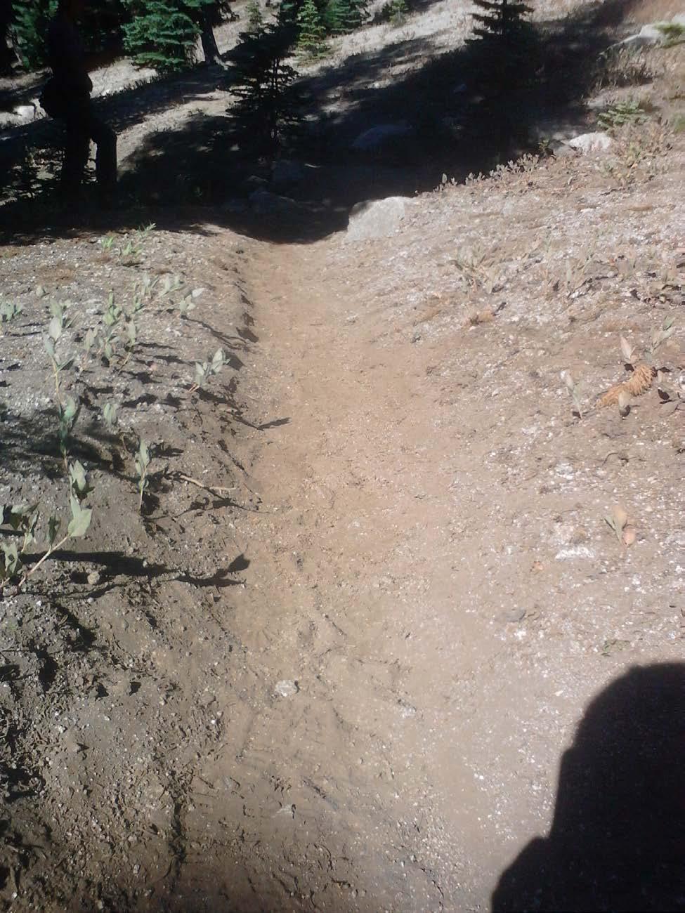
5 Project Objectives Accompanied by a GPS, I was able to go on a trail ready to take pictures and make waypoints on a GIS created map to geo-locate points of interest. This included noting rare plant species, invasive plant species, and also points that require any kind of maintenance. My trip to survey English Peak was one of my most information packed surveys. Large gulley s are being formed by the water coming down a large slope that is a drainage bowl for rain and snowfall. The objectives of this project were to stay overnight at English Peak in order to GPS waypoint and track where some of the larger gulley s are forming. These gulley s start as small ruts and form large gulley s where the water has the potential to move fast and cause a lot of erosion. This is a high priority area due to the rare high mountain meadows of the Klamath, and because of an important trail to get to a fire lookout at English Peak. A new drainage plan is to be made with the information gathered from this survey in order to protect the trail and the meadow below the drainage. All the ruts and gulley s drain into a rare high mountain meadow near English Peak and is in danger of being destroyed by water running too rapidly, thus creating large ruts. Rare plant species that live in symbiotic relationships are being wiped out in the Klamath due to over growth of conifers and watershed problems. These high mountain meadows of the Klamath are not only important because of the diversity of plants, but also for the ability of these meadows to spread water out over a large area. Spreading water as it comes down a mountain gives the soil some time to absorb the water coming down the mountain. When the water spreads out, it also loses velocity, causing less erosion to trails below. Erosion is a huge problem in the Klamath due to it s rugged, steep terrain so there is quite an effort being made to protect these meadows. The goals for this project was to gather information about the gulley s, mark where they are affecting trail, and try to come up with possible culprits for the erosion being done. All the goals were met in a two-day trip to English Peak since the drainage bowl watershed did not cover too much ground. My major is in Forest Management and Protection, so learning about how the watershed affects the trails and surrounding landscape is critical to me. Watershed is especially important to me living in San Diego since there is not much thought put into watershed here in San Diego and I see it regularly as an avid mountain biker and member of the San Diego Mountain Bike Association. Since it does not rain often, people tend to think it never rains, but when it does, it really shows the trail who is boss out here; that is nature. I was interested in this internship due to these reasons of wanting to make forest protection a career, and trail building a hobby while mountain biking. These goals have only been strengthened with the knowledge I have learned during my time in the Klamath National Forest. I was able to do everything I was told I was going to do in my internship thanks to my great supervisor/advisor Sam Commarto. My goals were to learn how to build a good trail with watershed and future generations in mind and those goals were met. I still wish I could do some more surveying and do a little more report making though, just to see what doing paperwork for the Forest Service is like in a management type position. Page 4
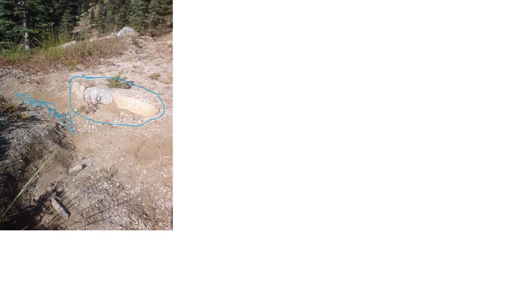
6 Project Approach In order to mark waypoints and make tracks of the ruts, my partner and I were given a tablet to record points of interest. Points of interest included areas of high erosion, fallen trees, rare trees/plant species, and most importantly, watershed. Watershed is one of the most important things in the Klamath National Forest due to its topography. My partner and I were always thinking about whether something is going to have an effect on the trail, and if so, how can we minimize that impact. After learning about the many different ways to minimize impact on the trail, and learning how to keep a trail a trail for many years, we were able to give comments and considerations for what could be done to help. My partner and I used a map generated by other interns in the recreation department and accessed the maps on an application called PDF Maps. This application allowed my partner and I to take pictures and record descriptions of any waypoint we marked. We were also able to make tracks of where we go on the map. With that tool, we were able to find, and locate where the ruts/gulley s are starting near the ridge, all the way down to the end of the gulley where the water runs into a large meadow. As we got GPS tracks of the gulley s, a tape measure was used to measure the size of the gulley and we were able to mark where each measurement that was made on the GIS map. The size of the gulley s was very important in order to observe whether the check dams that were installed were a good idea, or just making matters worse. Project Outcomes The problems at English Peak were solely a problem of watershed. Throughout the internship I cut and moved logs, rebuilt tread, maintained water bars, and moved boulders. In my opinion, most problems that arise on the trail were due to unmaintained water bars, or misplaced water bars. Logs and rocks are less a problem because they usually do not destroy or erode trail like water does. My partner and I ended up tracking more than 8 large gulley s, favoring the large ones causing the most damage. While tracking one of the largest gulley s an old trail was found. This old trail or old watershed area had water bars placed forcing the water to go vertically down the hill instead of horizontally, or parallel to the trail. These badly placed water bars seemed to be causing large amounts of water and dirt to flow down the mountain causing the large amounts of erosion that was noted. Check dams were also seen in many gulley s and some seem to have created a waterfall. These check dams that were put as Band- Aid s, in my opinion, were causing the water to pick up speed by creating 1-2 foot waterfalls. These badly placed check dams and water bars are focusing water into specific areas causing large amounts of erosion. If the water were to spread out, like meadows help do, the erosion in this area would be much Page 5
7 less despite the bad soil. The mountain side that forms a bowl and the loose, grainy soil near English Peak calls for an erosion disaster. Small plants and grasses also help spread out water, but the water bars are leaving the drainage bowl almost naked due to lack of water on the slope and an excess of water in the gulley s. After all the information is gathered and the hitch is over, the information is uploaded onto a google map to see in real time. Every waypoint and comment is transferred over to a computer and then uploaded onto google maps. Using google maps, I was able to see mine and my partners waypoints and GPS tracks on a satellite image map. This information is saved to be used for further analysis whether it be with a trail crew leader or a Biologist that works for the forest. Conclusion This internship experience really opened my eyes to all the hard work, planning, and research that is done in order to make sure our trails last a long time without regular maintenance. This project showed me how and what to observe when looking at any watershed area. Also, because I worked with the recreation department, we were also looking to see how the water affects the trail. There are many ways to maintain a trail with many different methods, but in my time with the Forest Service I learned that the mission is to look 10 or more years ahead while doing trail work. I was also able to talk to California Conservation Corp. back country trails crew, and they also had the same mission in mind while doing trail work. Band aids are not always the best option if you want something to be permanent. The experience and knowledge that I gained while in the Klamath, no doubt, will take me to where I want to be with the help of my degree. Learning about trails and the watershed is not only a goal for my career but also my hobby in mountain biking. Before my internship started in the Klamath, my supervisor had me and my partner go to ranger academy where we got our official Leave No Trace Trainer Certificate. This training taught me about how to camp in the backcountry while minimizing impact. All the things I learned during the internship are very diverse things but I believe together, all these skills only help me be a good steward of the trails and the public lands that we share. Whether it be representing my local mountain bike association, a company, or any agency in the future, I now have the confidence in the skills I acquired to be able to step forward and be a leader for others. This knowledge does not come easy and I can say that I did not know almost anything about really being in the backcountry so I had a lot of questions. From the experience at ranger academy and seeing other experiences on the news, I noticed that we were all taught to recycle and things of that nature, but when was anyone taught basic wilderness ethics that protect the environment outside our homes? Funny thing is, most people are in the same situation because the majority of people live in or cities. Education is key when talking about protecting our forests because the forest is not just one persons, or one agencies forest, it is public land that belongs to everyone. Page 6

8 Appendices A screenshot of the GIS created waypoints and tracks after being uploaded to google earth Page 7
9 An example of a bad trail because of the berm causing water to run down the trail instead of off the trail Page 8
10 Page 9
11 Pictures taken at the water bars that were found near the ridge that were placed along an old trail, or just a method to focus water off the mountain. Huge gulley s formed as a result of these water bars Page 10
12 Page 11

13 One of the many gulley s that are relentlessly trying to destroy the trail below Page 12
USDA Trails Strategy WRI: ENGLISH PEAK SURVEY. Theodore Mendoza San Diego State University June 6 th 2016 August 18 th Advisor: Sam Commarto
 WRI: ENGLISH PEAK SURVEY Theodore Mendoza San Diego State University June 6 th 2016 August 18 th 2016 Advisor: Sam Commarto Klamath National Forest Submitted: March 21, 2017 Table of Contents Acknowledgements
Kit Carson-Challenger Ridge Trail Project
 Kit Carson-Challenger Ridge Trail Project Project Accomplishments Report-USFS December 15, 2015 Photo courtesy of Justin Peterson 815 South 25 th Street, Suite 101 Colorado Springs, CO 80904 Dedicated
Non-motorized Trail Plan & Proposal. August 8, 2014
 Town of Star Valley Ranch, Wyoming and the Star Valley Ranch Association in partnership with the USDA Forest Service, Bridger-Teton National Forest, Greys River Ranger District Non-motorized Trail Plan
Trail Assessment Report
 Trail Assessment Report Trail Options for the Bear Creek Canyon located in Pikes Peak Ranger District, Pike National Forest and on Colorado Springs Utility Lands Due to the presence of a unique species
American Conservation Experience
 ACE Project Report For Tonto National Forest, Arizona Trail Association and Arizona State Parks Title of Project: 4 Peaks Trail Maintenance Award Contract Number: ASP NM11021 Project Partner: Paul Burghard
RE: Access Fund Comments on Yosemite National Park Wilderness Stewardship Plan, Preliminary Ideas and Concepts
 September 30, 2016 Superintendent Yosemite National Park Attn: Wilderness Stewardship Plan P.O. Box 577 Yosemite, CA 95389 RE: Access Fund Comments on Yosemite National Park Wilderness Stewardship Plan,
FINAL TESTIMONY 1 COMMITTEE ON RESOURCES UNITED STATES HOUSE OF REPRESENTATIVES. July 13, 2005 CONCERNING. Motorized Recreational Use of Federal Lands
 FINAL TESTIMONY 1 STATEMENT OF DALE BOSWORTH CHIEF Of the FOREST SERVICE UNITED STATES DEPARTMENT OF AGRICULTURE Before the SUBCOMMITTEE ON FORESTS AND FOREST HEALTH And the SUBCOMMITTEE ON NATIONAL PARKS,
Appendix C. Tenderfoot Mountain Trail System. Road and Trail Rehabilitation Plan
 Appendix C Tenderfoot Mountain Trail System Road and Trail Rehabilitation Plan All rehabilitation work would be under the direction of the District Fisheries Biologist, the Forest Hydrologist, and/or the
Los Padres National Forest: Santa Barbara Ranger District. Water Resources Projects Final Report
 1 Los Padres National Forest: Santa Barbara Ranger District Water Resources Projects Final Report Jose Gonzalez California State University, Bakersfield June 2018 August 2018 Veronica Garza: Zone Lands
Kennesaw Mountain Trail Club. Trail Skills Workshop ~ Dips and Drains. Presented by: Jay M Dement
 Kennesaw Mountain Trail Club Trail Skills Workshop ~ Dips and Drains Presented by: Jay M Dement KEY CONCEPTS: Control Erosion and Users Where Do Trails Come From, and How Do They Work: Concept of trail
Jericho Research Forest Recreational Trail Mapping and Assessment. Prepared for the University of Vermont Natural Areas
 Jericho Research Forest Recreational Trail Mapping and Assessment Prepared for the University of Vermont Natural Areas By the Land Stewardship Program (LANDS), July 2014 Table of Contents Executive Summary..
DECISION MEMO. Rawhide Trail #7073 Maintenance and Reconstruction
 Page 1 of 6 Background DECISION MEMO USDA Forest Service Jefferson Ranger District Jefferson County, Montana Rawhide Trail #7073 is located in the Elkhorn Mountain Range approximately 10 miles east of
Peter Axelson. Beneficial Designs, Inc. Minden, NV
 Peter Axelson Beneficial Designs, Inc. Minden, NV Arroya Sit Ski Mono Ski Dynamic Seating Spring Assist Cross Country Ski Hand Bike Adaptive Canoe Seating Available from Chosen Valley Canoe Accessories
ADOPT-A-TRAIL MANUAL C. Bailey-May
 ADOPT-A-TRAIL MANUAL C. Bailey-May 2011 1 ADOPT-A-TRAIL VOLUNTEER DUTIES Welcome to the White Mountain National Forest s Adopt-A-Trail (AAT) program and thank you for volunteering with us! This volunteer
ROAD AND TRAIL PROJECT APPROVAL
 ROAD AND TRAIL PROJECT APPROVAL www.marincountyparks.org Marin County Parks, 3501 Civic Center Dr, Suite 260, San Rafael, CA 94903 DATE: July 12, 2017 PRESERVE: Gary Giacomini Open Space Preserve PROJECT:
Decision Memo Broken Wheel Ranch Equestrian Outfitter Special-Use Permit Proposed Action
 Decision Memo Broken Wheel Ranch Equestrian Outfitter Special-Use Permit USDA Forest Service Mississippi Bluffs Ranger District, Shawnee National Forest Jackson and Union Counties, Illinois Proposed Action
Tracy Ridge Shared Use Trails and Plan Amendment Project
 Tracy Ridge Shared Use Trails and Plan Amendment Project Scoping Document Forest Service Allegheny National Forest Bradford Ranger District McKean, County, Pennsylvania In accordance with Federal civil
GOLDEN EARS PROVINCIAL PARK
 GOLDEN EARS PROVINCIAL PARK Trail Information as of October 10 th 2015 Do not underestimate the mountainous wilderness of Golden Ears Provincial Park. The combination of rugged terrain and rapidly changing
Hiking Las Vegas.com
 Hike: Mt. Wilson via First Creek Canyon route Trailhead: First Creek marked Distance: 10 miles up and back Elevation gain: 3,400 feet Elevation of Peak: 7,070 feet Time: 7 to 9 hours (up and back) Difficulty:
2012 Squaw Butte Trail Warriors
 2012 Squaw Butte Trail Warriors Between June 1 st and September 30 th 2012 Squaw Butte supported nine trail maintenance projects. These projects covered a large section of south western Idaho, taking place
September 14, Comments of the Colorado Trail Foundation On the USFS Scoping Notice of August 13, 2010 RE: the relocation of the CDNST/CT Page 1
 THE COLORADO TRAIL FOUNDATION Comments on the U.S. Forest Service Scoping Notice of August 13, 2010 Regarding the Relocation of THE COLORADO TRAIL AND CONTINENTAL DIVIDE NATIONAL SCENIC TRAIL From La Garita
Response to Public Comments
 Appendix D Response to Public Comments Comment Letter # Response 1, 2, 3, 4, 5, 7, 8, 9, 10, 11, 12, 13, 14, 15, 16, 17, 18, 19, 20, 22, 23, 24, 25, 26, 27, 29, 30, 31, 32, 33, 34, 35, 36, 37, 38, 39,
PROPOSED ACTION South 3000 East Salt Lake City, UT United States Department of Agriculture
 United States Department of Agriculture Forest Service Uinta-Wasatch-Cache National Forest Salt Lake Ranger District 6944 South 3000 East Salt Lake City, UT 84121 801-733-2660 File Code: 1950/2300 Date:
Appalachian Trail Sustainability Research Study
 Appalachian Trail Sustainability Research Study Appalachian National Scenic Trail 2,175 mile footpath from Maine to Georgia Crosses 14 states, 6 NPS units, and 8 National Forests, Managed by the NPS A.T.
MIDDLE SCHOOL CURRICULUM TR AILING ICE AGE M YST ERI E S SEARCHING GLACIAL FEATURES
 MIDDLE SCHOOL CURRICULUM TR AILING ICE AGE M YST ERI E S SEARCHING GLACIAL FEATURES CONTENTS I. Enduring Knowledge... 3 II. Teacher Background... 3 III. Before Viewing the Video... 5 IV. Viewing Guide...
RE: Extreme Avalanche Hazard at New Jumbo Glacier Resort (JGR) Daylodge Building Site
 Daylodge Building Site") To: Ms. Autumn Cousins Manager, Policy and Compliance BC Environmental Assessment Office, via Email to autumn.cousins@gov.bc.ca and eao.compliance@gov.bc.ca PO Box 9426 Stn Prov Govt Victoria, BC V8W 9V1
To: Ms. Autumn Cousins Manager, Policy and Compliance BC Environmental Assessment Office, via Email to autumn.cousins@gov.bc.ca and eao.compliance@gov.bc.ca PO Box 9426 Stn Prov Govt Victoria, BC V8W 9V1
April 19-21, See below for Course Descriptions. Columbia Cascades Trail Skills College Cascades Locks, Oregon.
 Columbia Cascades Trail Skills College Cascades Locks, Oregon April 19-21, 2013 Friday, April 19 198, 199 First Aid and CPR 300 Basic Rock Work 302 Water Crossings and Seeps 398 Working with Pack Stock
Bear Creek Habitat Improvement Project
 06/10/10 Bear Creek Habitat Improvement Project El Paso County, Colorado Pike National Forest and Colorado Springs Utilities Owned Land Report prepared by: Eric Billmeyer Executive Director Rocky Mountain
Kit Carson-Challenger Ridge Trail Project Annual Performance Report-2014 October 22, 2014
 1 Kit Carson-Challenger Ridge Trail Project Annual Performance Report-2014 October 22, 2014 Willow Lake and Kit Carson Peak 2 SUMMARY The Rocky Mountain Field Institute began Phase 1 of a multi-phase,
SEGMENT ASSESSMENT REPORT
 2017 SEGMENT ASSESSMENT REPORT SEGMENT 3: MT ROSE / TAHOE MEADOWS TO SPOONER SUMMIT REPORT SUMMARY This report is a compilation of information collected on the Tahoe Rim Trail during assessments performed
Photopoint Monitoring in the Adirondack Alpine Zone
 Photopoint Monitoring in the Adirondack Alpine Zone Julia Goren (PI) and Seth Jones Adirondack High Peaks Summit Steward Program Adirondack Mountain Club summit@adk.org PO Box 867, Lake Placid, NY 12946
2.0 PARK VISION AND ROLES
 2.0 PARK VISION AND ROLES 2.1 Significance in the Protected Area System Marble Range and Edge Hills provincial parks protect 6.8% of the Pavillion Ranges Ecosection, which is located in the Southern Interior
Itinerary Overview. Colorado San Juan Mountaineering 15-days
 Itinerary Overview Colorado San Juan Mountaineering 15-days Course Description Welcome, you re in for an experience of a lifetime! Imagine hiking through rolling forests, sharing alpine meadows with mountain
Itinerary Overview. Continental Divide Alpine Backpacking 22 days Ages Course Description
 Itinerary Overview Continental Divide Alpine Backpacking 22 days Ages 16-18 Course Description Welcome, you re in for an experience of a lifetime! Imagine hiking through rolling forests, sharing alpine
Allagash Wilderness Waterway Tramway Carry NFCT Waterway Work Trip July 15-17
 Allagash Wilderness Waterway Tramway Carry NFCT Waterway Work Trip July 15-17 Introduction: This is the first season that the NFCT will have an Allagash Stewardship Intern Crew. This will be a two person
Environment and Natural Resources Trust Fund 2017 Request for Proposals (RFP)
") Project Title: Total Project Budget: $ Environment and Natural Resources Trust Fund 2017 Request for Proposals (RFP) Floating Classroom: Connecting 20,000 Youth to Minnesota Waterways Category: Proposed
Project Title: Total Project Budget: $ Environment and Natural Resources Trust Fund 2017 Request for Proposals (RFP) Floating Classroom: Connecting 20,000 Youth to Minnesota Waterways Category: Proposed
Itinerary Overview. Sangre de Cristo Alpine Backpacking 22 days Ages Course Description
 Itinerary Overview Sangre de Cristo Alpine Backpacking 22 days Ages 16-18 Course Description Welcome, you re in for an experience of a lifetime! Imagine hiking through rolling forests, sharing alpine meadows
Logo Department Name Agency Organization Organization Address Information 5700 North Sabino Canyon Road
 Logo Department Name Agency Organization Organization Address Information United States Forest Coronado National Forest 5700 North Sabino Canyon Road Department of Service Santa Catalina Ranger District
White Mountain National Forest
 White Mountain National Forest United States Department of Agriculture Forest Service Eastern Region Boles Brook Snowmobile Bridge Decision Memo Boles Brook Snowmobile Bridge Project Town of Woodstock
MASTER PLAN EXECUTIVE SUMMARY
 Biscuit Run State Park Scottsville Road (State Route 20) Charlottesville, VA 22902 Biscuit Run State Park MASTER PLAN EXECUTIVE SUMMARY Department of Conservation and Recreation Division of Planning and
USDA Forest Service Deschutes National Forest DECISION MEMO. Round Lake Christian Camp Master Plan for Reconstruction and New Facilities
 USDA Forest Service Deschutes National Forest DECISION MEMO Round Lake Christian Camp Master Plan for Reconstruction and New Facilities Jefferson County, Oregon T. 13 S., R. 8 E., Section 16, W.M. Background:
Appendix 1: Best Management Practices For Hang Gliding and Paragliding in Jasper National Parks
 Appendix 1: Best Management Practices For Hang Gliding and Paragliding in Jasper National Parks Name of Best Management Practice Best Management Practices for Hang Gliding and Paragliding in Jasper National
Decision Memo for Desolation Trail: Mill D to Desolation Lake Trail Relocation
 for Salt Lake County, Utah Uinta-Wasatch-Cache National Forest Salt Lake Ranger District 1. Background The present location of the Desolation Trail (#1159) between Mill D and Desolation Lake follows old
Daisy Dean Trail 628/619 ATV Trail Construction
 Background and Purpose and Need The Daisy Dean ATV Trail Construction Project is located in the Little Belt Mountains, Musselshell Ranger District, Lewis and Clark National Forest approximately 32 miles
APPENDIX D: SUSTAINABLE TRAIL DESIGN. APPENDICES Town of Chili Parks and Recreation Master Plan Update
 APPENDIX D: SUSTAINABLE TRAIL DESIGN APPENDICES Town of Chili Parks and Recreation Master Plan Update Sustainable Trail Construction Sustainable trails are defined by the US Forest Service as trails having
PROPOSED PARK ALTERNATIVES
 8 Chimne y Rock State Park M a ster Pl an 2011 PROPOSED PARK ALTERNATIVES Introduction Three different park development concepts were prepared and presented to the citizens of North Carolina through a
A GIS Analysis of Probable High Recreation Use Areas in Three Sisters Wilderness Deschutes and Willamette National Forests
 Lindsey Kiesz Geo 565 Term Project 3/15/2010 A GIS Analysis of Probable High Recreation Use Areas in Three Sisters Wilderness Deschutes and Willamette National Forests Introduction The Three Sisters Wilderness
Sierra National Forest
 Sierra National Forest Summer 2018 Wilderness Ranger Intern Application Wilderness Intern Rangers are integral members of the wilderness team working in the Sierra National Forest s spectacular wilderness
Itinerary Overview. Maroon Bells Mountaineering 22-days. Course Description
 Itinerary Overview Maroon Bells Mountaineering 22-days Course Description Welcome, you re in for an experience of a lifetime! Imagine hiking through rolling forests, sharing alpine meadows with mountain
Thank you for the opportunity to comment on the proposed action to add trails and trailheads to the Red Rock District trail system.
 July 14, 2010 Jennifer Burns Red Rock Ranger District PO Box 20429 Sedona, AZ 86341 Flagstaff Biking Organization PO Box 23851 Flagstaff, AZ 86002 Dear Jennifer- Thank you for the opportunity to comment
Guthega to Mt Twynam. 2183m. 1583m. 6 hrs 45 mins 14.8 km Return. Experienced only. 913m
 Guthega to Mt Twynam 6 hrs 45 mins 14.8 km Return Experienced only 5 913m This walk starts from Guthega and makes its way along the Snowy River to the Illawong Lodge, via the Blue Cow Creek flying fox.
Itinerary Overview: What you will be doing Maroon Bells Alpine Backpacking 22 days
 Itinerary Overview: What you will be doing Maroon Bells Alpine Backpacking 22 days 0BCourse Description Welcome, you re in for an experience of a lifetime! Imagine hiking through rolling forests, sharing
Colorado s forests are slated to lose thousands of miles of roads through the new OHV Route Designation process. DON T LET IT HAPPEN!
 Colorado s forests are slated to lose thousands of miles of roads through the new OHV Route Designation process. DON T LET IT HAPPEN! This packet identifies many roads that you may lose if you don t act.
White Mountain National Forest. Campton Day Use Area Development Project. Scoping Report. Prepared by the Pemigewasset Ranger District May 2013
 White Mountain National Forest Campton Day Use Area Development Project United States Department of Agriculture Forest Service Eastern Region Towns of Thornton and Campton, Grafton County, NH Scoping Report
Itinerary Overview. Sawatch Range Mountaineering Ages days
 Itinerary Overview Sawatch Range Mountaineering Ages 14-16 22 days Course Description Welcome, you re in for an experience of a lifetime! Imagine hiking through rolling forests, sharing alpine meadows
Colorado Mountain Club 2015 Stewardship Team Program Accomplishments
 Summary In 2015, CMC launched a new Stewardship Team program and hired a crew of young (25 and under), natural resource professionals to increase capacity of public land management agencies and coordinate
Part 1: Introduction to Decision Making
 Part 1: Introduction to Decision Making 1.1 - Anatomy of a Decision ABOUT AIARE Learning Outcomes Identify that backcountry decision making involves five key components: Plan, Observe, Teamwork, Choose
Bradley Brook Relocation Project. Scoping Notice. Saco Ranger District. United States Department of Agriculture Forest Service
 Bradley Brook Relocation Project United States Department of Agriculture Forest Service Scoping Notice White Mountain National Forest February 2011 For Information Contact: Jenny Burnett White Mountain
Eco Explorer. Steps. Purpose
 Eco Explorer A n eco explorer is a person who investigates environmental issues and works to make positive changes to the environment. In this badge, you ll be an eco explorer as you take a look at different
Internship Announcement. Mount Rainier National Park. NPS Academy Internships 6 Positions. Please Respond By April 15, 2019
 NPS Academy Mount Rainier National Park Internship Announcement Mount Rainier National Park NPS Academy Internships 6 Positions Please Respond By April 15, 2019 The Northwest Youth Corps (NYC), in partnership
2017 EMPLOYEE SATISFACTION SURVEY RESULTS
 2017 EMPLOYEE SATISFACTION SURVEY RESULTS Office of Human Resources 2017 Employee Satisfaction Survey Results 2017 Employee Satisfaction Survey Results 0 P a g e 2017 Employee Satisfaction Survey Results
To: Cam Hooley From: Trails 2000 Date: September 30, 2016 Re: Hermosa Comments. Dear Cam:
 ! To: Cam Hooley From: Trails 2000 Date: September 30, 2016 Re: Hermosa Comments Dear Cam: Trails 2000 is commenting on the Forest Service Management Plan for the Hermosa Creek Watershed Management Plan
Itinerary Overview and Travel Information: 15-Day Alaska Alpine Backpacking Course for Adults
 Itinerary Overview and Travel Information: 15-Day Alaska Alpine Backpacking Course for Adults Course Description Welcome, you re in for the experience of a lifetime! Imagine hiking through rolling forests,
KENNESAW MOUNTAIN TRAIL CLUB WORKDAY
 WORKDAY 2-10-18 1 Trail ambassadors or others see next page. 1 work sites TOOLS 15 1 3 1 2 SCHEDULE: 7:15 Start load tools; Send registration stuff out 8:00 Send tools to grassy area near trail head. 8:15
Table of Contents. page 3 Long term Goals Project Scope Project History. 4 User Groups Defined Trail Representative Committee. 5 Trail Users Breakdown
 Launched April 27th, 2010 1 Table of Contents page 3 Long term Goals Project Scope Project History 4 User Groups Defined Trail Representative Committee 5 Trail Users Breakdown 13 Trail Users Desires 16
Survey of Littleton Down
 Survey of Littleton Down 05 November 2014 The Team: John and Jenny Barnard 1) Introduction Littleton Down (Hill Number 2911, Section 42, OS 1:50000 Map 197, OS 1:25000 Map 121, Grid Ref. SU941150) is listed
MUNICIPALITY OF ANCHORAGE
 MUNICIPALITY OF ANCHORAGE ANCHORAGE PARKS & RECREATION Memorandum PRC 08-56 DATE: 5 August 2008 TO: FROM: SUBJECT: Parks & Recreation Commission Holly Spoth-Torres, Park Planner PRC 08-56 Far North Bicentennial
Mission. Purpose. Idaho Trails Association promotes the continued enjoyment of Idaho s hiking trails.
 The Idaho Trails Association (ITA) is a non-profit 501(c)3. Mission Idaho Trails Association promotes the continued enjoyment of Idaho s hiking trails. Purpose To facilitate the active enjoyment of Idaho
2019 Work Week Crew. Schedule and Descriptions
 2019 Work Week Crew WAWONA WW1 Mariposa Grove Restoration and Invasive Plant Removal June 2 June 8 YOSEMITE VALLEY YV1 Washington Column Climber s Trail Rehabilitation June 9 June 15 YV2 Weed Warriors/
Submission on the Tukituki Catchment Proposal: EPA reference numbers; NSP 13/ , NSP 13/ , NSP 13/ , NSP 13/02.
 Hutt Valley Tramping Club PO Box 30 883 LOWER HUTT 5045 Tukituki Catchment Proposal Environmental Protection Agency Private Bag 63 002 WELLINGTON 6140 29 July 2013 Submission on the Tukituki Catchment
Decision Memo for Philmont Scout Ranch Bike Trail and Access Reroute Project
 Decision Memo Philmont Scout Ranch Bike Trail and Access Reroute Project USDA Forest Service, Southwestern Region Questa Ranger District, Carson National Forest Colfax County, New Mexico (T. 30N, R. 17E,
Bear Creek Watershed Restoration Project Final Project Report December 21, 2016
 Bear Creek Watershed Restoration Project Final Project Report December 21, 2016 Dedicated to the conservation and stewardship of public lands in Southern Colorado Rocky Mountain Field Institute 815 South
Grizzly Peak A - East Ridge July 15, 2012
 Grizzly Peak A - East Ridge July 15, 2012 Difficulty: Difficult Class 2/Class 3 Upper Elevation: 13,995 feet Trailhead Elevation: 11,360 feet Elevation Gain: 3,000 feet Round-trip Length: 6.0 miles Trailhead:
National Strategy for a Sustainable Trail System
 National Strategy for a Sustainable Trail System Forest Service December 30, 2016 Message from the Chief The Forest Service manages the largest trail system in the country, with unparalleled opportunities
Hiking Las Vegas.com
 Hike: Juniper Peak up and back Trailhead: Oak Creek Canyon marked Distance: 5.5 miles round trip Elevation gain: 2,200 feet Elevation peak: 6,109 feet Time: 4 to 5 hours - Up and back Difficulty: 3 Danger
Mikaela Weisse Scott Kloeck-Jenson Fellowship report Travel Award (2014) Lima, Peru
 Lima, Peru") Mikaela Weisse Scott Kloeck-Jenson Fellowship report Travel Award (2014) Lima, Peru I received a Scott Kloeck-Jenson fellowship to complete an international internship during the summer of 2014. I spent
Mikaela Weisse Scott Kloeck-Jenson Fellowship report Travel Award (2014) Lima, Peru I received a Scott Kloeck-Jenson fellowship to complete an international internship during the summer of 2014. I spent
David Johnson. Tom, Attached please find the final scoping letter and figures for your review. David
 David Johnson From: Sent: To: Cc: Subject: Attachments: David Johnson Tuesday, April 12, 2011 4:33 PM Thomas Malecek Dave Dyer; Jason Marks (jmarks@segroup.com) VWC Scoping Letter
Analysis and design of road and bridge infrastructure database using online system
 Analysis and design of road and bridge infrastructure database using online system Joni Arliansyah 1,*, Yadi Utama 2, Maureen Arlini Wijayanti 3, Rachmat Gusti 3,and Arifianto 3 1 Department of Civil Engineering
Coast to Crest Trail Corridor Hike
 Coast to Crest Trail Corridor Hike Jim Cunningham, Poway City Council member and Board Chair of the San Dieguito River Park in 2013 has embarked on a project to hike the entire 70-mile San Dieguito River
Central Cascades Wilderness Strategies Project
 Central Cascades Wilderness Strategies Project Wilderness is Unique What makes designated Wilderness different from other national forest lands? Wilderness Act of 1964 to assure that an increasing population
Geoscape Toronto The Oak Ridges Moraine Activity 2 - Page 1 of 10 Information Bulletin
 About 13,000 years ago as the Laurentide Ice Sheet melted, glacial meltwater accumulated between the ice sheet and the Niagara Escarpment. This formed a lake basin into which gravel and sand were deposited.
TRANSMITTAL. Please contact me with any questions. 7 Spruce Road, Freeport, ME T: (207)
") BAKER DESIGN CONSULTANTS Civil, Marine and Structural Engineering To: Alex Jaegerman FAICP Director of Planning & Development Town of Yarmouth 200 Main Street PO Box 907 Yarmouth, ME 04096 From: Barney
BAKER DESIGN CONSULTANTS Civil, Marine and Structural Engineering To: Alex Jaegerman FAICP Director of Planning & Development Town of Yarmouth 200 Main Street PO Box 907 Yarmouth, ME 04096 From: Barney
CENTER PIVOT TRACK MANAGEMENT OPTIONS
 Proceedings of the 28th Annual Central Plains Irrigation Conference, Kearney, Nebraska, February 23-24, 2016 Available from CPIA, 760 N. Thompson, Colby, Kansas CENTER PIVOT TRACK MANAGEMENT OPTIONS Steven
Understanding user expectations And planning for long term sustainability 1
 Understanding user expectations And planning for long term sustainability 1 What is a natural surface trail? It can be as simple has a mineral soil, mulched or graveled pathway, or as developed as elevated
Finally it was unloaded from the power carrier and moved into place using rock bars and brute strength.
 The Longest Mile It has been many years since work first began on this rugged and remote one-mile segment of the MCCT between Patti s Point and the Lower Log Boom on Pardee Watershed. EBMUD mounted patrolmen
Mt. Hood National Forest
 United States Department of Agriculture Forest Service Mt. Hood National Forest Zigzag Ranger District 70220 E. Highway 26 Zigzag, OR 97049 503-622-3191 Fax: 503-622-5622 File Code: 1950-1 Date: June 29,
Appendix A. Tenderfoot Mountain Motorcycle Trail System. Maintenance and Construction Plan (6/13/13)
") Appendix A Tenderfoot Mountain Motorcycle Trail System Maintenance and Construction Plan (6/13/13) If the decision to implement the project as approved, grant funding would be pursued to fund construction
Appendix A Tenderfoot Mountain Motorcycle Trail System Maintenance and Construction Plan (6/13/13) If the decision to implement the project as approved, grant funding would be pursued to fund construction
Final Research Progress Report: 9 August 2011
 Final Research Progress Report: 9 August 2011 Funds approved in current fiscal year: $ 26,058 Project contract number: CAC # 65103 Project title: Surveying Avocados in the Baja Peninsula for Pests that
Friends of Petrified Forest National Park
 I S S U E 7, J U L Y 2 0 1 4 Friends of Petrified Forest National Park Working together we can make a difference! Public Lands Day September 27, 2014 For Public Lands Day on September 27, Petrified Forest
Course Description. North Cascades Alpine Backpacking for Veterans
 Course Overview Join other Veterans in the North Cascades Range of Washington for the opportunity to connect outside of the military in one of the most remote and beautiful alpine environments in the lower
Trail Beginning Elevation: 7553 ft The Poison Creek Trailhead is located at the end of National Forest Road 646E (NF-646E).
.") West Mountain Trails Poison Creek Trail #134 Length: 2.9 miles (4.7 km) Difficulty Horseback: A good trail for the first time west mountain rider, some steep sections Hiking: Most Difficult USGS Maps:
West Mountain Trails Poison Creek Trail #134 Length: 2.9 miles (4.7 km) Difficulty Horseback: A good trail for the first time west mountain rider, some steep sections Hiking: Most Difficult USGS Maps:
Aviation Operations. Program Learning Outcomes. Program Description. Career Options
 Aviation Operations Award Type Commercial Pilot 6 Flight Instructor 7 Helicopter Operations 9 Instrument Pilot 8 11 Private Pilot 6 Remote Pilot 8 Team Resource Management 9 Management 18 Professional
Backpacking Trip Planning. Presenters: Dana Perry Christine Fogarty
 Backpacking Trip Planning Presenters: Dana Perry Christine Fogarty 1 Agenda New to planning trips? Location and physical trail Common terminology Trip selection & research The Trip Flow Plan What is it
MOUNTAIN BIKING THE CASCADE LOOP
 MOUNTAIN BIKING THE CASCADE LOOP By Henry Freimuth All photographs by Henry Freimuth The Cascades are on the Spanish Creek, which is a tributary of the Feather River. The Feather River was named by Spanish
ROPE Outdoor Trip Leader
 ROPE Outdoor Trip Leader Pay Rate: Stipend (See below for benefits) Supervisor: Assistant Director, Outdoor Programs Contact: kjc5@rice.edu or 713-348-4069 Job Description: ROPE Trip Leaders are responsible
DRONING FOR INFORMATION
 DRONING FOR INFORMATION Opportunity of Drones for Surveying and Mapping Practices By: Adam Smith, CP Matt Aguirre, PLS Overview Introduction Background Problem and Opportunity Issues and Mitigations Implementation
Marble: 7:09 am Creede: 1:01 pm Today s Airtime: 5.8 hrs Cartographic length 351 miles. Total PIC Time: Total Logged Time 1623.
 Monday, September 11, 2017 Cobra flight #600, PIC #613, 1 landings Misty Meadows, Clear Creek Falls, Lost Lakes, Ute Ridge, Silex, Rio Grande Pyramid, Hossick Lake, Pagosa Peak, Chama Headwaters and Falls,
LEAVE NO TRACE CENTER FOR OUTDOOR ETHICS CONSULTING SERVICES
 LEAVE NO TRACE CENTER FOR OUTDOOR ETHICS CONSULTING SERVICES LEAVE NO TRACE PURPOSE Americans love the outdoors. Today, more than 300 million people visit America s national parks and another 150 million
Installing a Drainage Chimney. Written by Nevin Sunday, 28 May :35 - Last Updated Tuesday, 18 July :52
 Many, many years ago when we put the first tanks on the back of the garage, the council inspector had said that I needed to put in a rubble drain to take the stormwater from the roof of the garage. This
Franklin Falls. NFCT Waterway Work Trip July Introduction: Driving directions and meeting location: Camping and lodging: Food:
 Franklin Falls NFCT Waterway Work Trip July 16-18 Introduction: Last year the NFCT Stewardship Interns and Volunteers installed approximately 20 stone steps on the Permanent Rapids Carry. We also planted