Colorado s Instream Flow Program at 40. ICWP Annual Conference October 16, 2013 Denver, Colorado
|
|
|
- Owen Stanley
- 6 years ago
- Views:
Transcription

1 Colorado s Instream Flow Program at 40 ICWP Annual Conference October 16, 2013 Denver, Colorado
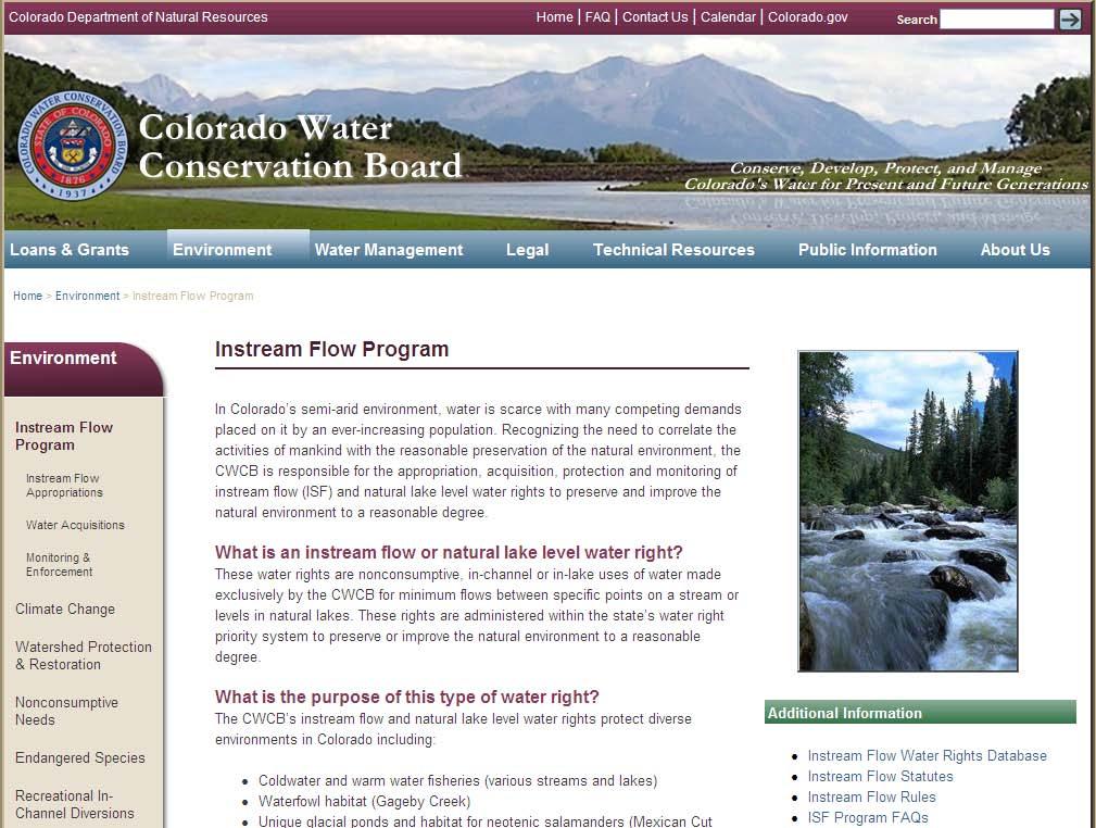
2 ISF Program established in 1973 by Senate Bill 97 Recognized the need to correlate the activities of mankind with some reasonable preservation of the natural environment Vested the CWCB with the authority on behalf of the people of the state of Colorado, to appropriate or acquire such waters of natural streams and lakes as may be required to preserve the natural environment to a reasonable degree.
3 Senate Bill Introduced in response to federal imposition of bypass flows on West Slope (Fry-Ark project) Wanted to maintain state control over water in Colorado and provide regulatory certainty ISFs provided a way to protect water instream past point of bypass Bill also introduced in response to threats of ballot initiative to allow private ISFs
4 Since 1973, the CWCB has Appropriated instream flow water and natural lake level rights on close to 1,500 stream segments, covering 9,005 miles of stream, Acquired Over 25 water right donations or long-term contracts for water totaling 500 cfs and 9,344 AF and 480 natural lakes
5 Role of ISF Program in Water Community Coordinate with federal agencies to address their resource protection goals through state-held water rights Work with water suppliers to enable water projects to move forward while protecting natural environment Collaborate with conservation groups and other stakeholder groups on protecting Colorado s rivers and streams

6 1980 Windy Gap Project ISF appropriations on the main stem of the Colorado River Protected flows downstream from Windy Gap Reservoir Integral part of Northern WCD s settlement with Middle Park water users
7 1985 Summit County Agreements Series of agreements between CWCB and various Summit County entities Provided ISF protection on local streams (high quality fisheries on Blue River and tributaries) Allowed certain levels of snowmaking diversions and water development in Summit County Provided basis for county and ski areas to meet NEPA requirements and secure GMR water service contracts from USBR
8 1990 Boulder Creek Donation Donation Agreement between City of Boulder and CWCB Conveyed senior water rights to CWCB for ISF use in Boulder and North Boulder Creeks Donated water supplemented decreed ISFs that are junior to several irrigation rights City relied on Agreement in discussions with USFS Helped satisfy federal requirements related to City s municipal diversions on Boulder Creek

9 Mile Reach ISF USFWS recommendation to maintain and enhance Colorado pikeminnow habitat and contribute to sufficient progress under the Recovery Program Seasonal ISF of 581 cfs July September (reduced from FWS recommendation of 700-1,200 cfs)
 Bird species (black swifts) and riparian vegetation cited as part of unique natural")
10 1996 Dead Horse Creek and Hanging Lake Cooperative effort between USFS and CWCB supported by local stakeholders ISF for all unappropriated flow based upon unique hydrologic and geologic natural environment of watershed, including Bridal Veil Falls and Hanging Lake (NLL water right on lake) Bird species (black swifts) and riparian vegetation cited as part of unique natural env t

11 Wilderness Area ISFs on Big Dominguez and Little Dominguez Creeks BLM recommendation: ALL of the annually available flow, with an allowance for additional water development on private and federal lands above the Wilderness Area. Very different from typical ISF appropriation Aspects of natural environment preserved Flow amounts Development allowance

12 Language from Act establishing Wilderness Area Purpose: to conserve and protect for the benefit and enjoyment of present and future generations the water resources of area streams, based on seasonally available flows, which are necessary to support aquatic, riparian and terrestrial species and communities. CWCB to appropriate ISF water rights to support wilderness management purposes in lieu of a federal water right. Coordination among River District, Wilderness Society, BLM, CPW and CWCB on legislation.
13 Temporary Leases of Water for ISF Use Provide an option to irrigators in dry years with insufficient water to irrigate crops Furthers policy of preventing permanent dry-up of agricultural lands Temporary leases: Limited to ISF use for a period of 120 days; 3 years of use over a 10-year period Can be used on any stream where CWCB currently holds an ISF water right, up to decreed amount Expedited administrative approval conditioned on no injury to other water rights


14 Permanent Water Acquisitions for ISF Use Peabody Ditch (Moser) (Boulder Creek and Blue River) Carbon Lake Ditch (Mineral Creek and Big Horn Gulch) Stapleton Brothers Ditch Maroon Creek and RF River
15 ISF water rights as a tool in developing alternatives to Wild & Scenic designation ISF water rights can provide permanent protection of some flowrelated Outstandingly Remarkable Values (ORVs) Fish and recreational fishing, wildlife, riparian vegetation through a decreed water right administered within Colorado s priority system; and eliminate potential for a federal water right if part of an alternative management plan accepted by feds
16 Upper Colorado River Stakeholder Group Local governments, water users, environmental and recreation interests, landowners, state agencies Developed river management plan alternative for BLM /USFS to consider in their planning process ISFs for base flow a key element of Plan three ISF reaches on Colorado River decreed this year. Plan is preferred alternative in draft EIS Potential to protect higher flows through voluntary cooperative arrangements, possibly via the ISF water acquisition program.
17
Colorado s Instream Flow Program at 40. Celebrating 40 Years of Success and Challenges January 15, 2014 Denver, Colorado
 Colorado s Instream Flow Program at 40 Celebrating 40 Years of Success and Challenges January 15, 2014 Denver, Colorado ISF Program established in 1973 by Senate Bill 97 Recognized the need to correlate
January 14,2010. Ms. Linda Bassi Colorado Water Conservation Board 1313 Sherman Street, Room 723 Denver, CO Dear Linda,
 STATE OF COLORADO Bill Ritter, Jr., Governor DEPARTMENT OF NATURAL RESOURCES DIVISION OF WILDLIFE AN EQUAL OPPORTUNITY EMPLOYER Thomas E. Remington, Director 6060 Broadway Denver, Colorado 80216 Telephone:
Piedra River Protection Workgroup Meeting # 15 January 15, 2013 Ross Aragon Community Center, Pagosa Springs, Colo.
 Piedra River Protection Workgroup Meeting # 15 January 15, 2013 Ross Aragon Community Center, Pagosa Springs, Colo. What happened at this meeting? 1. Final river segment analysis completed. 2. Discussion
Piedra River Protection Workgroup Meeting #5 Feb. 21, 2012 Ross Aragon Community Center, Pagosa Springs
 Piedra River Protection Workgroup Meeting #5 Feb. 21, 2012 Ross Aragon Community Center, Pagosa Springs What happened at this meeting? - Identified conservation easements - Discussed In-stream Flows -
BUCK POINT RANCH. Aspen Associates Realty
 BUCK POINT RANCH Aspen Associates Realty www.aspenassociatesrealty.com 970.544.5800 WELCOME TO Buck Point Ranch is a 960± acre property located in one of the last pristine valleys in close proximity to
WEKIVA WILD AND SCENIC RIVER ACT OF 2000
 PUBLIC LAW 106 299 OCT. 13, 2000 WEKIVA WILD AND SCENIC RIVER ACT OF 2000 VerDate 11-MAY-2000 01:59 Oct 20, 2000 Jkt 069139 PO 00000 Frm 00001 Fmt 6579 Sfmt 6579 E:\PUBLAW\PUBL299.106 APPS27 PsN: PUBL299
Brinker Creek Ranch. Colorado - Routt County - Yampa
 Located at the base of the Flattops Range in the Steamboat/Vail corridor, Brinker Creek Ranch consists of 1,451 acres ideally suited for high country grazing and native grass hay production. Traditionally
SECTION 3 GENERAL DESCRIPTION OF THE RIVER BASIN
 SECTION 3 GENERAL DESCRIPTION OF THE RIVER BASIN SECTION 3 GENERAL DESCRIPTION OF THE RIVER BASIN River basin description. A general description of the river basin or subbasin, as appropriate, in which
Poudre River District 3. Irrigation Ditch Construction in Fort Collins - Late 19 th Century
 Poudre River District 3 Irrigation Ditch Construction in Fort Collins - Late 19 th Century Where Does the Water in the Poudre Come From? Three main sources Native River Water C-BT System Water Other Transbasin
2016 Trails Maintenance and Operating Costs
 2016 Trails Maintenance and Operating Costs Motorized Trails Maintenance for motorized trails comes from vehicle registration fees and a portion of the federal Recreation Trails Program (RTP) funds. The
112th CONGRESS. 1st Session H. R. 113 IN THE HOUSE OF REPRESENTATIVES
 HR 113 IH 112th CONGRESS 1st Session H. R. 113 To provide for additions to the Cucamonga and Sheep Mountain Wilderness Areas in the Angeles and San Bernardino National Forests and the protection of existing
Wilderness Areas Designated by the White Pine County bill
 Wilderness Areas Designated by the White Pine County bill SEC. 321. SHORT TITLE. This subtitle may be cited as the `Pam White Wilderness Act of 2006'. SEC. 322. FINDINGS. Congress finds that-- The White
The Partnership Wild & Scenic Rivers Program
 BUDGET REQUEST FISCAL YEAR 2017 Proven, cost-effective protection for 770 miles of rivers and thousands of acres of riparian land Westfield River, MA (L) and Farmington River, CT (R) Partnership Wild &
GRAND JUNCTION FIELD OFFICE. Travel Management Plan U.S. Department of the Interior Bureau of Land Management
 Travel Management Plan U.S. Department of the Interior Bureau of Land Management Land Status by County Mesa Garfield Montrose Rio Blanco Total BLM Surface Lands 721,700 322,600 17,100 0 1,061,400 Federal
H. R IN THE HOUSE OF REPRESENTATIVES
 I 113TH CONGRESS 1ST SESSION H. R. 1776 To establish the Clear Creek National Recreation Area in San Benito and Fresno Counties, to designate the Joaquin Rocks Wilderness in such counties, to designate
Securing Permanent Protection for Public Land
 Securing Permanent Protection for Public Land Tools for Wyoming Advocates Paul Spitler* The Wilderness Society * I am a wilderness policy expert, not a powerpoint expert! Platform and Resolutions of the
Bear Creek Habitat Improvement Project
 06/10/10 Bear Creek Habitat Improvement Project El Paso County, Colorado Pike National Forest and Colorado Springs Utilities Owned Land Report prepared by: Eric Billmeyer Executive Director Rocky Mountain
EMERY COUNTY PUBLIC LAND MANAGEMENT ACT OF 2018 S. 2809/H.R. 5727
 EMERY COUNTY PUBLIC LAND MANAGEMENT ACT OF 2018 S. 2809/H.R. 5727 September 25, 2018 OVERVIEW The Emery County Public Land Management Act of 2018 is a significant step backwards for wilderness and conservation
RATTLESNAKE HILL PHILLIPS, HARRIS FARM, LIME KILN & QUARRY
 Town of, MA Trails Map 6a SPLIT ROCK PRIMARY SECONDARY PRIVATE PRIVATE PROPERY STAY ON HEAD FUTURE TO SKINNER (NOT MARKED) 0 miles 0.25 0.250 0.5 Mapbox, Data Odbl, OpenStreetMap contributors primary use
FOR MORE INFORMATION VISIT: SUMMITCOUNTYCO.GOV STATE OF THE OPEN SPACE REPORT
 FOR MORE INFORMATION VISIT: SUMMITCOUNTYCO.GOV 2018 STATE OF THE OPEN SPACE REPORT Open Space And Trails Program At a Glance 16,102+ acres protected; 8,187 ac in fee simple ~ $1,250,000/year allocated
Whitefish Range Partnership Tentatively Approved by WRP 11/18/2013!Rec. Wilderness Page 1
 Whitefish Range Partnership Tentatively Approved by WRP 11/18/2013!Rec. Wilderness Page 1 Recommended Wilderness Background The Whitefish Range has a long management and legislative history associated
Rule Governing the Designation and Establishment of All-Terrain Vehicle Use Trails on State Land
 Rule Governing the Designation and Establishment of All-Terrain Vehicle Use Trails on State Land 1.0 Authority 1.1 This rule is promulgated pursuant to 23 V.S.A. 3506. Section 3506 (b)(4) states that an
INFORMATION NOTICE 15-2 Limited & Excluded Lands
 INFORMATION NOTICE 15-2 Limited & Excluded Lands Schedule 1 (Land Description) of onshore petroleum Agreements issued by the Department of Energy details the total hectares calculated. Total hectares are
April 10, Mark Stiles San Juan Public Lands Center Manager 15 Burnett Court Durango, CO Dear Mark,
 Mark Stiles San Juan Public Lands Center Manager 15 Burnett Court Durango, CO 81301 Dear Mark, We are pleased to offer the following comments on the draft San Juan Public Lands Center management plans
Existing Resource Information
 Botanical and Wildlife Vegetation alliances/wildlife habitats Grasslands annual/perennial Chaparral mixed/montane/chamise-redshank Riparian montane/valley foothill riparian Sierran mixed conifer Montane
GRANTEE REPORTS May 2015
 GRANTEE REPORTS May 2015 Photo: Bob Wick. THE CONSERVATION ALLIANCE Grantee Update In April 2014, The Conservation Alliance invested $750,000 in grassroots conservation organizations. Each grant went to
Arthur Carhart National Wilderness Training Center s Wilderness Investigations High School
 Arthur Carhart National Training Center s Investigations High School 101/Lesson 2 (OPTION 2B) Introducing the Act Goal: Students will understand the difference between wild spaces and federally designated
June 22, Superintendent Jock Whitworth Zion National Park Springdale, UT Re: Wild and Scenic River Management Plans
 Nathan Fey Colorado Stewardship Director 1601 Longs Peak Avenue Longmont, Colorado 80501 nathan@americanwhitewater.org June 22, 2010 Superintendent Jock Whitworth Zion National Park Springdale, UT 84767-1099
Continental Divide National Scenic Trail Legislative History and Planning Guidance
 Continental Divide National Scenic Trail Legislative History and Planning Guidance Legislation, Policy, and Direction Regarding National Scenic Trails The National Trails System Act, P.L. 90-543, was passed
General Overview: Acreage:
 General Overview: The Beaver Creek Ranch is located on Beaver Creek in Shell Wyoming, at the base of the western slope of the Big Horn Mountains, one of the west s most spectacular back drops. With an
Colorado Parks and Wildlife Commission July 10, Raquel Wertsbaugh, CNAP Coordinator
 Colorado Natural Areas Program Logan Wash Mine Designation Colorado Parks and Wildlife Commission July 10, 2014 Raquel Wertsbaugh, CNAP Coordinator raquel.wertsbaugh@state.co.us Colorado Natural Areas
How should the proposed protected area be administered and managed?
 SPERRGEBIET CONSERVATION PLANNING Questionnaire In big words the main objectives of this questionnaire are to contribute to: 1. finding approaches and mechanism for implementing a multi-use protected area
Welcome and thank you for being here! Kick-Off Public Workshop November 19, 2014
 Welcome and thank you for being here! Kick-Off Public Workshop November 19, 2014 OPEN SPACE MATTERS: Boise s First Reserve Master Plan Julia Grant Foothills and Open Space Manager City of Boise Ellen Campfield
Description of the Proposed Action for the Big Creek / Yellow Pine Travel Plan (Snow-free Season) and Big Creek Ford Project
 and Big Creek Ford Project") Description of the Proposed Action for the Big Creek / Yellow Pine Travel Plan (Snow-free Season) and Big Creek Ford Project Payette National Forest Krassel Ranger District Valley and Idaho Counties, Idaho
Description of the Proposed Action for the Big Creek / Yellow Pine Travel Plan (Snow-free Season) and Big Creek Ford Project Payette National Forest Krassel Ranger District Valley and Idaho Counties, Idaho
STATE OF NEW MEXICO S INITIAL DISCLOSURES. The Plaintiff, State of New Mexico ex rel. State Engineer ( State ), hereby makes its
, hereby makes its") STATE OF NEW MEXICO COUNTY OF SAN JUAN ELEVENTH JUDICIAL DISTRICT STATE OF NEW MEXICO, ex rel. STATE ENGINEER, v. Plaintiff, THE UNITED STATES OF AMERICA, et al., Defendants, CV-75-184 HON. JAMES J. WECHSLER
STATE OF NEW MEXICO COUNTY OF SAN JUAN ELEVENTH JUDICIAL DISTRICT STATE OF NEW MEXICO, ex rel. STATE ENGINEER, v. Plaintiff, THE UNITED STATES OF AMERICA, et al., Defendants, CV-75-184 HON. JAMES J. WECHSLER
$850,000 Awarded to 20 Organizations
 $850,000 Awarded to 20 Organizations The Conservation Alliance is pleased to fund the following organizations to support their efforts to protect wild lands and waterways for their habitat and recreation
Appendix I. Wilderness Review
 Appendix I. Wilderness Review This appendix contains the wilderness inventory conducted for the Ash Meadows, Moapa Valley, and Pahranagat National Wildlife Refuges (NWRs) as part of the Comprehensive Conservation
II. THE BOULDER CREEK DRAINAGE BASIN
 II. THE BOULDER CREEK DRAINAGE BASIN This section provides an overview of the watersheds and flood hazards associated with Boulder Creek and South Boulder Creek including descriptions of the drainage basins,
MCARTHUR SWAMP PLANNING UNIT Pit-McCloud River Watershed
 Existing Conditions & Uses Overview Spring-fed lake and rivers; valuable grazing lands and important waterfowl area Planning unit provides the only public access to Ahjumawi Lava Springs State Park 7,596
Establishing a National Urban Park in the Rouge Valley
 STAFF REPORT ACTION REQUIRED Establishing a National Urban Park in the Rouge Valley Date: March 29, 2012 To: From: Wards: Reference Number: Executive Committee Deputy City Manager, Cluster B All p:\2012\cluster
Mark West Creek Flow Study Report
 Mark West Creek Flow Study Report Biology and Geology of Mark West Creek The headwaters of Mark West Creek are located in the Mayacamas Mountain range, which border Napa and Sonoma County, where it then
BA Collaborators. Driftless Area Initiative The Prairie Enthusiasts Trout Unlimited TNC TCF Natural Resources Foundation of Wisconsin
 BA Collaborators Driftless Area Initiative The Prairie Enthusiasts Trout Unlimited TNC TCF Natural Resources Foundation of Wisconsin The mission of the of the Blufflands Alliance is to actively conserve
Sasagiu Rapids Provincial Park. Draft Management Plan
 Sasagiu Rapids Provincial Park Draft Management Plan 2 Sasagiu Rapids Provincial Park Table of Contents 1. Introduction... 3 2. Background and Park Attributes... 3 2.1 Park History.... 3 2.2 Natural Features...
Our Valley Our Heritage
 Case Statement for Our Valley Our Heritage Preserving Hardscrabble Ranch in Brush Creek Valley Eagle Valley Land Trust Prepared by: Robin Thompson June and July 2017 All photos courtesy of Ed Roberson,
Green Legacy. Securing our. Greenlands Strategy
 Greenlands Strategy Securing our Green Legacy Together we can create an interconnected network of Greenlands for the health and well-being of the environment and future generations Caring for the Credit
Park-specific management and policies Wainuiomata Recreation Area
 Park-specific management and policies Wainuiomata Recreation Area 6.8 Wainuiomata Recreation Area 6.8.1 Legal status Title held: Legislative status: Wellington Regional Council Administered under Local
PAD-US 1.1 (CBI Edition) Management Designations. National Parks (NPS) and National Park
 Management Designations. National Parks (NPS) and National Park") Noise Sensitive Areas Avoidance Criteria & Source PAD-US 1.1 (CBI Edition) Management Designations Falcon View "DESGINATE" Field Terminology Falcon View Display Category Boundary Waters Canoe Wilderness
Noise Sensitive Areas Avoidance Criteria & Source PAD-US 1.1 (CBI Edition) Management Designations Falcon View "DESGINATE" Field Terminology Falcon View Display Category Boundary Waters Canoe Wilderness
Lewis and Clark National Historic Trail
 National Trails System Land and Water Conservation Fund FY2014 Lewis and Clark National Historic Trail Total LWCF Request: $ 3,130,000 Project Name Agency District # Tracts Acres Total Cost Columbia River
Hermosa Area Preservation The Colorado Trail Foundation 4/11/2008
 Hermosa Area Preservation The Colorado Trail Foundation 4/11/2008 Legend d o Tr ail NPA - National Protection Area ra NCA - National Conservation Area o e C Th The Colorado Trail lo FS inventoried Roadless
Federal Land and Resource Management: A Primer 1
 Federal Land and Resource Management: A Primer 1 RS20002 Coordinated by Ross W. Gorte Natural Resource Economist and Policy Specialist Environment and Natural Resources Policy Division December 22, 1998
BACKCOUNTRY TRAIL FLOOD REHABILITATION PROGRAM
 BACKCOUNTRY TRAIL FLOOD REHABILITATION PROGRAM Backcountry Trail Flood Rehabilitation A June 2013 Flood Recovery Program Summary In June 2013, parts of Southern Alberta were devastated from significant
Global Sustainable Tourism Destinations Criteria
 Global Sustainable Tourism Destinations Criteria Draft destination level Global Sustainable Tourism Criteria as proposed after Destinations and International Standards joint working group meeting and follow-up
David S Brookshire (UNM) Craig D. Broadbent (IWU) Don Coursey (U of C) Vince Tidwell (Sandia) SILPE
 Craig D. Broadbent (IWU) Don Coursey (U of C) Vince Tidwell (Sandia) SILPE") David S Brookshire (UNM) Craig D. Broadbent (IWU) Don Coursey (U of C) Vince Tidwell (Sandia) SILPE 1 Introduction Over the course of 5 years we engaged with stake holders to design a real-time marketplace
David S Brookshire (UNM) Craig D. Broadbent (IWU) Don Coursey (U of C) Vince Tidwell (Sandia) SILPE 1 Introduction Over the course of 5 years we engaged with stake holders to design a real-time marketplace
Galveston Bay Estuary Program. Carla G. Guthrie, Ph.D. Galveston Bay Council Member Texas Water Development Board
 Galveston Bay Estuary Program Carla G. Guthrie, Ph.D. Galveston Bay Council Member Texas Water Development Board The statements contained in this presentation are my current views and opinions and are
Wilderness Process #NP-1810: Your letter ID is NP September 5, 2018
 Wilderness Process #NP-1810: Your letter ID is NP-1810-2602-96 September 5, 2018 RE: GMUG Wilderness Evaluation Revised Evaluation Criteria and Draft Report Forest Revision Planning Team: The Continental
ARTWEI ARTWEI ARTWEI
 Protection / Management Plans for Natura 2000 areas and Maritime Spatial Plan for internal sea waters - including the Szczecin Lagoon Szczecin, 7th May 2011 Andrzej Zych Inspectorate of Coast Protection
National Wild and Scenic River RESOURCE ASSESSMENT CRESCENT CREEK
 National Wild and Scenic River RESOURCE ASSESSMENT CRESCENT CREEK August, 2015 National Wild and Scenic River CRESCENT CREEK RESOURCE ASSESSMENT Table of Contents I. SUMMARY... 1 II. INTRODUCTION... 1
% farmers/private landowners in watershed applying BMPs. Other (Number of participants completed the training)
") Easygrants ID: 23803 National Fish and Wildlife Foundation NFWF/Legacy Grant Project ID: 0302.10.023803 U. S. Coral Reef Task Force Partnership Initiative 2010 - Submit Final Programmatic Report (Activities
Easygrants ID: 23803 National Fish and Wildlife Foundation NFWF/Legacy Grant Project ID: 0302.10.023803 U. S. Coral Reef Task Force Partnership Initiative 2010 - Submit Final Programmatic Report (Activities
Policy PL Date Issued February 10, 2014
 Subject RENEWABLE ENERGY ON CROWN LAND Compiled by Renewable Energy Program, Biodiversity Branch Replaces Policy Directives Waterpower Site Release Crown Land Onshore Windpower Development - Crown Land
MAA 5 Year Approved Projects List FY through FY
 MAA 5 Year Approved Projects List FY 2018 19 through FY 2022 23 AA01 Miramontes Ridge: Gateway to the Coast Public Access, Stream Restoration and Agriculture Enhancement AA01 Miramontes Ridge: Gateway
White Oak Creek. Recreational Use Attainability Analysis Summary of Findings. Texas Institute for Applied Environmental Research Stephenville, Texas
 White Oak Creek Recreational Use Attainability Analysis Summary of Findings Texas Institute for Applied Environmental Research Stephenville, Texas August 8, 2016 Sulphur Springs, Texas August 9, 2016 Mount
USGS Efforts to Consolidate Geospatial Data in the Federal Government
 ++ 1 USGS Efforts to Consolidate Geospatial Data in the Federal Government An overview of USGS trails collaborations and updates. Date 5/31/2017 Greg Matthews + Introduction USGS The following slides provide
Fossil Creek Wild & Scenic River Comprehensive River Management Plan Forest Service Proposed Action - details March 28, 2011
 Fossil Creek Wild & Scenic River Comprehensive River Management Plan Forest Service Proposed Action - details March 28, 2011 Primary Goals of the Proposed Action 1. Maintain or enhance ORVs primarily by
Dr. Christopher Brown New Mexico State University GEF Project Rio Meeting Ciudad Juárez, México 3-5 October 2006
 Political and Institutional Aspects of Rio Grande/ Río Bravo Basin Management Dr. Christopher Brown New Mexico State University GEF Project Rio Meeting Ciudad Juárez, México 3-5 October 2006 Institutional
Daisy Dean Trail 628/619 ATV Trail Construction
 Background and Purpose and Need The Daisy Dean ATV Trail Construction Project is located in the Little Belt Mountains, Musselshell Ranger District, Lewis and Clark National Forest approximately 32 miles
Southern Shenandoah Valley Chapter
 Southern Shenandoah Valley Chapter June 7, 2018 Members of the State Water Control Board c/o Office of Regulatory Affairs, Department of Environmental Quality P.O. Box 1105 Richmond, Virginia 23218 citizenboards@deq.virginia.gov
Sibley LUPA. Board Executive Committee Meeting December 7, 2017
 Sibley LUPA Board Executive Committee Meeting December 7, 2017 Project Location & Project Area 1,318-acre Robert Sibley Volcanic Regional Preserve Project Area Purpose Project Purpose & Goals Append the
To: Cam Hooley From: Trails 2000 Date: September 30, 2016 Re: Hermosa Comments. Dear Cam:
 ! To: Cam Hooley From: Trails 2000 Date: September 30, 2016 Re: Hermosa Comments Dear Cam: Trails 2000 is commenting on the Forest Service Management Plan for the Hermosa Creek Watershed Management Plan
PROUDLY BRINGING YOU CANADA AT ITS BEST. Management Planning Program NEWSLETTER #1 OCTOBER, 2000
 PROUDLY BRINGING YOU CANADA AT ITS BEST VUNTUT NATIONAL PARK Management Planning Program NEWSLETTER #1 OCTOBER, 2000 INTRODUCTION This newsletter launches the development of the first management plan for
Recreation in the Battle River Basin: Overview. John Thompson, Watrecon Consulting
 Recreation in the Battle River Basin: Overview John Thompson, Watrecon Consulting Recreation Rates for Alberta & Battle Basin Households 1996 2004 Battle Basin Alberta Battle Basin Alberta Bird Watching
South Colony Basin Recreation Fee Proposal
 South Colony Basin Recreation Fee Proposal Purpose and Need for Collecting Fees in South Colony Basin: Forest Service appropriated funds have not been sufficient to maintain current recreational services
A GUIDE TO MANITOBA PROTECTED AREAS & LANDS PROTECTION
 A GUIDE TO MANITOBA PROTECTED AREAS & LANDS PROTECTION Manitoba Wildands December 2008 Discussions about the establishment of protected lands need to be clear about the definition of protection. We will
Conservation Partners for the National Reserve System Program: a Western NSW focus
 Conservation Partners for the National Reserve System Program: a Western NSW focus Cooper, N. 1, Webber, L. 2, Nicolson, K. 3 1 Department of Environment, Climate Change and Water NSW, PO Box 788 Broken
Expanding Settlement Growing Mechanization
 The Wilderness Act of 1964 Expanding Settlement Growing Mechanization Versus Wilderness protection is paper thin, and the paper should be the best we can get that upon which Congress prints its Acts. David
CHAPTER 5. Chapter 5 Recreation Element
 CHAPTER 5 Recreation Element Chapter 5 Recreation Element The Recreation Element of the Meyers Area Plan is a supplement to the Recreation Element of the TRPA Regional Plan and the El Dorado County General
Conservation Area Management Statement
 Conservation Area Management Statement Miller Creek Wildlife Area Resolution #: Approval: Issue Date: Date of Last Revision: Table of Contents 1. Purpose....... 1 2. Property Description...... 1 2.1. Legal
OPEN SPACE. The Open Space Element describes the County s goals and policies with respect to open space areas and addresses the following topics:
 PURPOSE This element addresses open spaces for: the managed production of resources, outdoor recreation, public health and safety, and the preservation of natural resources. Amador County s open space
DECISION MEMO. Rawhide Trail #7073 Maintenance and Reconstruction
 Page 1 of 6 Background DECISION MEMO USDA Forest Service Jefferson Ranger District Jefferson County, Montana Rawhide Trail #7073 is located in the Elkhorn Mountain Range approximately 10 miles east of
River Protection Workgroup Information Sheet
 River Protection Workgroup Information Sheet Vallecito Creek and Pine River (Version: 7/5/11) http://ocs.fortlewis.edu/riverprotection This Initial Information Sheet was prepared to inform participants
KANANASKIS COUNTRY PROVINCIAL RECREATION AREAS MANAGEMENT PLAN DRAFT TERMS OF REFERENCE - November 20, 2007
 KANANASKIS COUNTRY PROVINCIAL RECREATION AREAS MANAGEMENT PLAN DRAFT TERMS OF REFERENCE - November 20, 2007 BACKGROUND There are 42 Provincial Recreation Areas (PRAs) within Kananaskis Country located
LOCAL PLAN FOR THE MANAGEMENT OF THE APPALACHIAN TRAIL IN MAINE. (GRAFTON NOTCH TO KATAHDIN) 1 January 2013 (Revised 5 February 2014)
 1 January 2013 (Revised 5 February 2014)") LOCAL PLAN FOR THE MANAGEMENT OF THE APPALACHIAN TRAIL IN MAINE (GRAFTON NOTCH TO KATAHDIN) 1 January 2013 (Revised 5 February 2014) The Appalachian Trail is a way, continuous from Katahdin in Maine to
LOCAL PLAN FOR THE MANAGEMENT OF THE APPALACHIAN TRAIL IN MAINE (GRAFTON NOTCH TO KATAHDIN) 1 January 2013 (Revised 5 February 2014) The Appalachian Trail is a way, continuous from Katahdin in Maine to
National Recreation Trail Application for Designation
 National Recreation Trail Application for Designation Introduction Thank you for your interest in the National Recreation Trail (NRT) program. Completed NRT application packages must be submitted by December
Nez Perce National Historic Trail. Land and Water Conservation Fund FY2014 Request
 FY2014 Request National Trails System FY2014 Total LWCF Request: $2,840,000 Project Name Agency District # Tracts Acres Total Cost Cow Island and Cow Creek BLM MT-1 2 779 $1,600,000 (in conjunction with
TO: ALL PERSONS INTERESTED IN WATER APPLICATIONS IN SAID WATER DIVISION NO. 7
 DISTRICT COURT, WATER DIVISION 7, COLORADO WATER RESUME TO: ALL PERSONS INTERESTED IN WATER APPLICATIONS IN SAID WATER DIVISION NO. 7 Pursuant to C.R.S. 37-92-302, you are notified that the following is
APPENDIX. Alberta Land Stewardship Act AMENDMENTS TO THE SOUTH SASKATCHEWAN REGIONAL PLAN
 APPENDIX Alberta Land Stewardship Act AMENDMENTS TO THE SOUTH SASKATCHEWAN REGIONAL PLAN 1 All references to Alberta Environment and Sustainable Resource Development, Environment and Sustainable Resource
FINAL TESTIMONY 1 COMMITTEE ON RESOURCES UNITED STATES HOUSE OF REPRESENTATIVES. July 13, 2005 CONCERNING. Motorized Recreational Use of Federal Lands
 FINAL TESTIMONY 1 STATEMENT OF DALE BOSWORTH CHIEF Of the FOREST SERVICE UNITED STATES DEPARTMENT OF AGRICULTURE Before the SUBCOMMITTEE ON FORESTS AND FOREST HEALTH And the SUBCOMMITTEE ON NATIONAL PARKS,
City of Durango 5.8 FUNDING TRAILS DEVELOPMENT
 5.8 FUNDING TRAILS DEVELOPMENT The City has been successful in establishing dedicated local funding sources as well as applying for grants to develop the City s trail system, having received nearly $2.4
TETON COUNTY WYOMING PUBLIC LANDS INITIATIVE: TURIANO TEAM PROPOSAL
 TETON COUNTY WYOMING PUBLIC LANDS INITIATIVE: TURIANO TEAM PROPOSAL SUMMARY Protect roadless areas on US Forest Service lands in Teton County, Wyoming using a mix of two designations: National Backcountry
Rouge National Park. Opportunities and Challenges
 Rouge National Park Opportunities and Challenges January 2013 Rouge Park Finch Meander Rouge Beach at Lake Ontario Toronto GLWQA Area of Concern Rouge National Park Nationally Significant First Nation
DISTRICT COURT, WATER DIV. 6, COLORADO TO ALL PERSONS INTERESTED IN WATER APPLICATIONS IN WATER DIV. 6
 DISTRICT COURT, WATER DIV. 6, COLORADO TO ALL PERSONS INTERESTED IN WATER APPLICATIONS IN WATER DIV. 6 Pursuant to C.R.S. 37-92-302, you are hereby notified that the following pages comprise a resume of
BACKGROUND DECISION. Decision Memo Page 1 of 6
 DECISION MEMO DEVIL S ELBOW BY-PASS, BOUNDARY TRAIL NO.1 U.S. FOREST SERVICE T9N, R7E, SECTION 9 RANGE 5E COWLITZ COUNTY WA MOUNT ST. HELENS NATIONAL VOLCANIC MONUMENT, GIFFORD PINCHOT NATIONAL FOREST
The Conservation Contributions of Ecotourism Cassandra Wardle
 The Conservation Contributions of Ecotourism Cassandra Wardle PhD Candidate, Gold Coast, Australia Supervisors: Ralf Buckley, Aishath Shakeela and Guy Castley State of the Environment State of the Environment
Appendix C. Tenderfoot Mountain Trail System. Road and Trail Rehabilitation Plan
 Appendix C Tenderfoot Mountain Trail System Road and Trail Rehabilitation Plan All rehabilitation work would be under the direction of the District Fisheries Biologist, the Forest Hydrologist, and/or the
Acres Monterey County, California OPEN GROUND IN SALINAS VALLEY VEGETABLE AND STRAWBERRY PROPERTY
 324 +- Acres Monterey County, California OPEN GROUND IN SALINAS VALLEY VEGETABLE AND STRAWBERRY PROPERTY EXCLUSIVELY PRESENTED BY: Morris Garcia License 00834407 (559) 994-7453 Cell Sarah Donaldson License
Three Ball Ranch BOULDER, WYOMING. Hunting Ranching Fly Fishing Conservation
 Three Ball Ranch BOULDER, WYOMING Hunting Ranching Fly Fishing Conservation Three Ball Ranch BOULDER, WYOMING Introduction: Offered for sale for the first time ever is the historic Three Ball Ranch. Homesteaded
Evaluation of Outstanding Remarkable Values for Collawash River March 2011
 Evaluation of Outstanding Remarkable Values for Collawash River March 0 Segment From headwaters of East Fork Collawash River to Buckeye Creek Mileage: miles Free flowing: Yes Scenic:, Substantial River
Parks & Recreation Areas Program
 PARKS & RECREATION Parks & Recreation Areas Program As part of its mission to conserve and protect natural resources, the Upper Big Blue Natural Resources District (NRD) has been involved in several large-scale
1803 West Hwy 160 Monte Vista, CO (719) TTY (719)
 TTY (719)") USDA Forest Service Rio Grande National Forest http://www.fs.fed.us/r2/riogrande 1803 West Hwy 160 Monte Vista, CO 81144 (719)852-5941 TTY (719)852-6271 USDI Bureau of Land Management San Luis Valley Center
USDA Forest Service Rio Grande National Forest http://www.fs.fed.us/r2/riogrande 1803 West Hwy 160 Monte Vista, CO 81144 (719)852-5941 TTY (719)852-6271 USDI Bureau of Land Management San Luis Valley Center
WILDERNESS PLANNING. Wilderness. Interagency Regional Wilderness Stewardship Training. Alamosa, Colorado - March 26-29, 2007
 WILDERNESS PLANNING Interagency Regional Wilderness Stewardship Training Alamosa, Colorado - March 26-29, 2007 Suzanne Stutzman Lead Planner/Wilderness Coordinator National Park Service, Intermountain
S Central Coast Heritage Protection Act APRIL 21, 2016
 STATEMENT OF GLENN CASAMASSA ASSOCIATE DEPUTY CHIEF, NATIONAL FOREST SYSTEM U.S. FOREST SERVICE U.S. DEPARTMENT OF AGRICULTURE BEFORE THE UNITED STATES SENATE COMMITTEE ON ENERGY AND NATURAL RESOURCES