Environmental Development of River Road Ranch
|
|
|
- Abel Lyons
- 6 years ago
- Views:
Transcription

1 Environmental Development of River Road Ranch New Braunfels, Texas Alix Scarborough GEO 3426 April 2012
2 Introduction The 2,400-acre Word-Borcher ranch has been owned by the Word family since Located along the Guadalupe River in the Texas Hill Country, the land is both beautiful and environmentally sensitive, as it is also in the recharge zone of the Edward s Aquifer. On the other hand, with the rapid growth of the Central Texas Region in recent years, development pressures have been increasing for this large piece of land near the City of New Braunfels, TX, in Comal County. (See locator map, Figure 1.) Only Figure acres of the property are currently within the city limits, but the municipal government has been threatening to annex the rest of the area as demand for housing grows around the city. Though most of the land is still in its natural state and the family would like to keep it that way, they have recently realized that, realistically, the valuable property will need to be developed sooner rather than later. In order to maintain some control over the land s development, the property owners are working with a development company to create a mutually-agreeable master plan. As it currently stands, this plan includes a mix of residential and commercial, as well as a technical college. The portion consisting of the northeastern 662 acres along the Guadalupe River, separated from the rest of the property by River Road, is designated as a tourism area. This section is referred to as River Road Ranch. (See Figure 2.) 2

3 Figure 2 The current plan for River Road Ranch is anchored by a large, upscale resort along the bank of the Guadalupe River. The choice to promote tourism in the area is an obvious one; Tourism is one of the biggest economic drivers in New Braunfels, due in part to the river and the city s location between Austin and San Antonio. However, a large building next to a flood-prone body of water is environmentally irresponsible. An expensive conference center and resort will not be affordable to many people, including the lower-income residents of nearby small towns. It will do nothing to protect potential habitat for the many engendered species in Central Texas, including black-capped vireo, golden-cheeked warbler, and whooping crane. Perhaps most significant to the developer, this land use may not be the most profitable option. My proposal is to develop River Road Ranch less intensely while positioning it as a regional tourism destination. Figure 3 illustrates the unique amenities this plan can provide by 3
4 utilizing the available natural resources. Crucial to this type of development is building in a sustainable way, which includes situating elements appropriately on the land. The focus of this project is finding the best locations at River Road Ranch for three amenities: cabins, campsites, and trails. River Road Ranch Amenities Four price tiers of lodging options Birding and stargazing pavilion Botanical gardens Horse stables Sustainable small-scale agriculture Indoor/outdoor event pavilion Wildlife preserve Guest lodge with bar Interactive educational opportunities Upscale restaurant Hike and bike trails Casual café Accessible walking trails Partnerships with local businesses Figure 3 Geographic Concepts Locating these amenities involved a careful consideration of the site s resources and natural attributes, as well as existing man-made features and the needs of the future visitors. Drainage is the direction water flows downhill during a precipitation event, which is especially relevant because the Guadalupe River borders the eastern edge of this property. Due to topography, some regions of the property drain directly into the river instead of stopping off at local ponds, creating a drainage buffer along the river. This flood-prone and environmentally sensitive area is not appropriate for buildings (such as cabins), but temporary structures such as tents can take advantage of the river s edge. As well as affecting drainage patterns, slope is a barrier for certain types of development. Campsites will be restricted to areas of very gentle slope, so that tents can comfortably be set up. Cabins sites can be slightly more sloped, as small areas can be leveled as the cabins are built. 4
5 There are four main types of habitat within the River Road Ranch property: shrubland, pasture with scattered trees, oak-juniper woodlands, and riparian. These are determined primarily by the type and density of plants. Oak-juniper woodlands are ideal for cabins, as the denser trees provide shade. Campsites are more flexible with placement; either oak-juniper woodlands or pastureland with scattered trees is appropriate. For unloading heavy camping equipment, campsites should be near the property s main interior road. For privacy, on the other hand, all lodging should have a further proximity from public roads surrounding the property, especially the housing development along the southeast border of River Road Ranch. Data and Methodology Data Sources Several pdf and jpeg documents were originally compiled by consultants and obtained from Jennifer Word on behalf of the Word family. Maps of drainage patterns and habitat types were spatially referenced and digitized into polygons, as was the property boundary. The main interior road and smaller cow paths were estimated from aerial imagery. The rest of the data were downloaded from the Texas Tech University Center for Geospatial Technology. Comal County roads and rivers are Census TIGER files, and the Comal County DEM was created as part of the National Mapping Program. In addition, county boundaries were downloaded from the Texas Natural Resources Information System web site. All datasets were in North American Geographic Coordinate System, datum Cabin Location 5
6 The criteria for locating the cabins are summarized in figure 5. The purpose of these criteria was to narrow down the potential area in which to build cabins on the River Road Ranch property. The overall strategy was to create a raster layer with a value of one for each of the four criteria, then multiply them together. After digitizing the drainage areas map, I selected and created a new layer from the direct Guadalupe River drainage area. This polygon along the river was then erased from the River Road Ranch polygon, in order to show areas that do not fall within the drainage region, and the resulting polygon converted to raster data. Next, I selected by attributes all sections labeled habitat three (oak-juniper woodlands) from the digitized habitat map, then converted this total habitat three area to raster. Cabin Area Location Criteria Outside direct Guadalupe River drainage area Oak-juniper woodlands habitat Slope less than 10 degrees At least 1,000 feet from adjacent public roads Figure 5 To determine sufficiently flat areas, a slope layer was created from the Comal County DEM (clipped to the property boundaries). The slope layer was reclassified such that slopes of less than ten degrees were labeled one and slopes of greater than ten were labeled zero. Finally, roads adjacent to or near the property were selected from Comal County roads. These included River Road to the north and west, and Edwards Blvd and its various cul-de-sacs to the southeast. Roads across the river were disregarded. I created a 1,000 foot buffer from these selected roads, erased the buffer from the property boundary polygon, and converted the resulting area to a raster dataset with a value of one. These four raster layers were multiplied together, two by two, using raster calculator. The few areas that resulted in a value of zero were reclassified to no data since they were not part of the final location area. The ultimate output was a raster layer showing two regions that meet all four criteria identified earlier as ideal for 6

7 building cabins. The model I built, containing almost all operations described above, is shown in Figure 6 below. Figure 6 Campsite Location The criteria for locating the campsites are summarized in Figure 7. A process very similar to the one described in Cabin Location was used to find ideal areas for placing campsites. First, a 600 foot buffer was created around the section of the Guadalupe River that bordered the property. This buffer was converted to raster data with a value of one, for the purposes of later multiplying it with other criteria layers. Next, habitat types two and three (pastureland with scattered trees or oak-juniper woodlands) were selected from the habitats layer using SQL. These habitat areas were then converted to a single raster dataset. Campsite Area Location Criteria Less than 600 feet from Guadalupe River Pastureland with scattered trees or oak-juniper woodlands habitat Slope less than 5 degrees Less than 200 feet from interior main road Figure 7 7

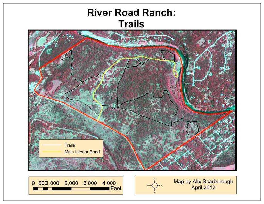
8 The slope layer created to identify cabin areas was reused, this time reclassified such that a slope of less than 5 degrees had a value of one and a slope of greater than 5 degrees had a value of zero. For the final criteria, a buffer of 200 feet was created from the main interior road on the property. This was converted to raster, and multiplied with the other three criteria layers (and reclassified to show only the acceptable areas) to identify a final region where campsites should be located. The model for this section of the project is shown is Figure 8. Figure 8 Trail Location For trail location, instead of conducting a location analysis similar to the previous two, I chose to use only an aerial image. This is because the most efficient way of locating trails on this property was to utilize existing roads and cow paths, which can be seen as lighter lines indicating cleared linear areas. There are currently no paved roads on the property, but many years of wandering cattle and trucks creatures of habit both have worn paths through the underbrush and trees. These span most of the property, and go through a variety of habitats while generally taking the path of least resistance. (Cows and trucks prefer not to climb steep hills if it can be 8
9 avoided.) These existing paths are therefore ideal for humans to walk or bike, and are less costly to implement as only minimal maintenance will be needed to make them usable. To create these polylines, I simply digitized from the aerial image, occasionally overlaying the DEM and habitat layers to ensure cleared areas were in fact paths, and not come other confounding variable. Analysis and Conclusions For my cabin location, my final output showed two areas on the property that would be ideal for building cabins according to the specified criteria. The total area for these suitable regions is 5,930,000 square feet. Since this area is so large, adding another variable to the location analysis could help narrow the area down for a future project. This variable could be determined by conducting a more thorough site visit and identifying additional barriers to development. The campsite output was also in two regions. They more closely reflected my expectation for ideal campsite placement. Figure 9 shows both the potential cabin area and the potential campsite area. My trail creation yielded several miles of multi-use trails on the property. They are all loops and most connect to other trails to facilitate the flow and ease of navigation. Trails go through each type of habitat, giving visitors a complete overview of the land s unique characteristics. (See Figure 10.) The next steps for this project, should the Word family decide to take this plan into consideration, would be to locate the larger buildings, such as the lodge and café. An environmental impact assessment would also be important, given the property s location in the Edward s Aquifer Recharge Zone. 9

10 Figure 9 Figure 10 10
A GIS Analysis of Probable High Recreation Use Areas in Three Sisters Wilderness Deschutes and Willamette National Forests
 Lindsey Kiesz Geo 565 Term Project 3/15/2010 A GIS Analysis of Probable High Recreation Use Areas in Three Sisters Wilderness Deschutes and Willamette National Forests Introduction The Three Sisters Wilderness
2.0 Physical Characteristics
 _ 2.0 Physical Characteristics 2.1 Existing Land Use for the Project The site is comprised of approximately 114 acres bounded by Highway 101 to the north, the existing town of Los Alamos to the east, State
Satisfying the Need: Finding Potential Campsite Locations in Farewell Canyon, B.C. Alexis Moore
 Satisfying the Need: Finding Potential Campsite Locations in Farewell Canyon, B.C. Alexis Moore 230075923 Geog 413 Final Project Write- Up Roger Wheate April. 13, 2012 Introduction & Purpose of Study The
FEASIBILITY CRITERIA
 This chapter describes the methodology and criteria used to evaluate the feasibility of developing trails throughout the study areas. Land availability, habitat sensitivity, roadway crossings and on-street
Classifications, Inventory and Level of Service
 Classifications, Inventory and Level of Service Section 3 Kenmore Park, Recreation and Open Space Plan 1 P a g e Classifications and Inventory Park Classifications Kenmore classifies its parks based upon
Digital Terrain Analysis of Archer Mountain
 Digital Terrain Analysis of Archer Mountain Identifying a potential new recreational trail Photo: Justin Bush GEOG 593 - Duh Marcus Tobey Justin Bush Project Overview Background Project Area Overview Questions
CAMPER CHARACTERISTICS DIFFER AT PUBLIC AND COMMERCIAL CAMPGROUNDS IN NEW ENGLAND
 CAMPER CHARACTERISTICS DIFFER AT PUBLIC AND COMMERCIAL CAMPGROUNDS IN NEW ENGLAND Ahact. Early findings from a 5-year panel survey of New England campers' changing leisure habits are reported. A significant
Proposed Arthurs Point Special Housing Area. Housing Accords and Special Housing Areas Act Expression of Interest
 Proposed Arthurs Point Special Housing Area Housing Accords and Special Housing Areas Act 2013 Expression of Interest 1.0 APPLICANT The applicant for the proposed Arthurs Point Special Housing Area is
Southwest Quadrant Distinctive Features
 SOUTHWEST QUADRANT Southwest Quadrant Distinctive Features LAND USE The 31.17 square mile Southwest Quadrant includes all the area within the planning area west of I-5 and south of the Sacramento River.
URBAN DESIGN REPORT. Proposed Residential Development, Old Church Road, Caledon East
 Proposed Residential Development, Old Church Road, Caledon East TABLE CONTENTS: 1.0 DEVELOPMENT 1.1 Introduction-Analysis of Guiding Principles and Documents 1.2 Community Design and Architectural Design
2. Goals and Policies. The following are the adopted Parks and Trails Goals for Stillwater Township:
 D. PARKS AND TRAILS 1. Introduction Stillwater Township s population is relatively low, with most residents living on rural residences on large lots. The need for active park space has been minimal in
LAS VARAS RANCH CA COASTAL TRAIL PROPOSED ALIGNMENT
 LAS VARAS RANCH CA COASTAL TRAIL PROPOSED ALIGNMENT Santa Barbara Trails Council * Prepared by Ray Ford February 1,2012 The following notes accompany the Santa Barbara Trails Council map for the Las Varas
Geoscape Toronto The Oak Ridges Moraine Activity 2 - Page 1 of 10 Information Bulletin
 About 13,000 years ago as the Laurentide Ice Sheet melted, glacial meltwater accumulated between the ice sheet and the Niagara Escarpment. This formed a lake basin into which gravel and sand were deposited.
Silver Lake Park An Environmental Jewel for the Citizens of Prince William County
 Silver Lake Park An Environmental Jewel for the Citizens of Prince William County The Prince William Park Authority Mission Statement states: The Prince William County Park Authority will create quality
Sunrise Ranch 6890 acres, Jeff Davis County, Texas On the Fort Davis Scenic Loop
 Sunrise Ranch 6890 acres, Jeff Davis County, Texas On the Fort Davis Scenic Loop 432-386-2821 Cell 432-426-2024 Office james@kinglandwater.com King Land & Water LLC P.O. Box 109, 600 State Street, Fort
TENNESSEE MOUNTAIN LIVING
 NOVEMBER 2016 Featuring Jasper Highlands TNLand.com END of the YEAR December 26th to Land Sale December 31st See back cover for more info... TENNESSEE MOUNTAIN LIVING JASPER HIGHLANDS - TENNESSEE'S MOST
Blanco Creek Ranch Acres, Uvalde County, Texas
 Blanco Creek Ranch 1208.30 Acres, Uvalde County, Texas James King, Agent Office 432 426.2024 Cell 432 386.2821 James@KingLandWater.com Blanco Creek Ranch 1208.30 acres Uvalde County, Texas James King,
17: Good Design - Tombs Site
 Rural Design Workbook: 17: Good Design - Tombs Site Site Introduction: The Tombs/Sullivan/Horton site is located within the Town of Campbell and is a combination of three properties totaling 356 acres:
LYNDHURST NEW URBAN DEVELOPMENT AREA STRUCTURE PLAN. Lyndhurst New Urban Development Area Structure Plan OUTCOMES AND PERFORMANCE STANDARDS
 APPENDIX 15.1-3 LYNDHURST NEW URBAN DEVELOPMENT AREA STRUCTURE PLAN Purpose of the Structure Plan Lyndhurst New Urban Development Area Structure Plan OUTCOMES AND PERFORMANCE STANDARDS LSP-P1 The District
THOMAS A. SWIFT METROPARK Introductions History Present Conditions Future Development Plans Implementation Strategies Statistics
 THOMAS A. SWIFT METROPARK Introductions History Present Conditions Future Development Plans Implementation Strategies Statistics Introduction As an open meadow park positioned along the Mahoning River,
TAYLOR CANYON RANCH COLORADO - ROUTT COUNTY - STEAMBOAT SPRINGS
 TAYLOR CANYON RANCH COLORADO - ROUTT COUNTY - STEAMBOAT SPRINGS Tucked up against the steep valley shaped by Mt. Pau and rising to the Routt National Forest, Taylor Canyon Ranch is an easily accessible,
Considerations for Facility Consolidation
 Considerations for Facility Consolidation ATC Guild, New Delhi, India October 21, 2010 Mimi Dobbs Overview Why consider consolidation? Co location vs Consolidation Consolidating Methodologies Areas to
USE OF 3D GIS IN ANALYSIS OF AIRSPACE OBSTRUCTIONS
 USE OF 3D GIS IN ANALYSIS OF AIRSPACE OBSTRUCTIONS A project by by Samuka D. W. F19/1461/2010 Supervisor; Dr D. N. Siriba 1 Background and Problem Statement The Airports in Kenya are the main link between
CRAZY HORSE TRAIL GUIDE
 CRAZY HORSE TRAIL GUIDE Abridged Version: July 2016 This is a short form of our interpretive trail guide for the Crazy Horse Trail. The full version of the guide has a more detailed description of the
CHAPTER ONE LITERATURE REVIEW
 CHAPTER ONE LITERATURE REVIEW LITERATURE REVIEW This chapter summarizes the most recently published community impact studies and articles that relate to multiuse trails. The review focuses on publications
SOUTH INTERCHANGE AREA
 Santaquin City General Plan 1 Location and Characteristics The South Interchange Area of Santaquin is located west of Interstate 15 and south of 500 South (Figure 1). It includes properties already annexed
Understanding user expectations And planning for long term sustainability 1
 Understanding user expectations And planning for long term sustainability 1 What is a natural surface trail? It can be as simple has a mineral soil, mulched or graveled pathway, or as developed as elevated
APPENDIX OFFICIAL MAP ORDINANCE OF HAMILTONBAN TOWNSHIP OFFICIAL MAP NARRATIVE
 APPENDIX A OFFICIAL MAP ORDINANCE OF HAMILTONBAN TOWNSHIP OFFICIAL MAP NARRATIVE INTRODUCTION: The Official Map of Hamiltonban Township has been prepared to identify those lands and features that Hamiltonban
Evaluating Lodging Opportunities
 Evaluating Lodging Opportunities This section explores market opportunities for new lodging accommodations in the downtown area. It will help you understand travel and visitation trends, existing competition,
Longmont to Boulder Regional Trail Jay Road Connection DRAFT FINAL REPORT
 Longmont to Boulder Regional Trail Jay Road Connection DRAFT FINAL REPORT December 2018 Project Summary Boulder County, Colorado, in partnership with the City of Boulder, is evaluating options for multi-use
SUMMER VILLAGE OF SILVER SANDS. Municipal Development Plan
 SUMMER VILLAGE OF SILVER SANDS Municipal Development Plan Bylaw 253-2014 Adopted August 22, 2014 Summer Village of Silver Sands Municipal Development Plan Bylaw No. 253-2014 Page 2 1 INTRODUCTION 1.1 SETTING
Disaster Evacuation Safe Zones in Clackamas County, Oregon Analysis: Two Scenarios
 Disaster Evacuation Safe Zone Analysis for Clackamas County, Oregon Part One: Caroline Rouwalk Part Two: Kathy Jepson June 3, 2008 http://gallery.photo.net/photo/5297534-md.jpg Disaster Evacuation Safe
2009 Muskoka Airport Economic Impact Study
 2009 Muskoka Airport Economic Impact Study November 4, 2009 Prepared by The District of Muskoka Planning and Economic Development Department BACKGROUND The Muskoka Airport is situated at the north end
FLORIDA DEPARTMENT OF ENVIRONMENTAL PROTECTION DIVISION OF RECREATION AND PARKS RECREATIONAL CARRYING CAPACITY GUIDELINES
 FLORIDA DEPARTMENT OF ENVIRONMENTAL PROTECTION DIVISION OF RECREATION AND PARKS RECREATIONAL CARRYING CAPACITY GUIDELINES THE SELECTION AND CAPACITY DETERMINATION OF USE SITES Introduction The Division
Trail Phasing Plan. Note: Trails in the Clear Creek Canyon area (Segments will be finalized in the future to minimize wildlife impacts
 Note: Trails in the Clear Creek Canyon area (Segments 2 5 and a future JCOS connection) will be finalized in the future to minimize wildlife impacts Trail Phasing Plan P Parking 3 Easy Trail Intermediate
Note that the steepest 8 direction pour point model slope in direction 64 is: 10.0
 GIS in Water Resources Exercise #3 Solution Part 1. 1.1 Hand Calculations (i) The standard ESRI surface slope function Grid size 10 m Diagonal distance= 14.142 m 47.5 48 47.7 50.6 48.3 dz/dx= -0.125 45.1
Proposed Action. Payette National Forest Over-Snow Grooming in Valley, Adams and Idaho Counties. United States Department of Agriculture
 United States Department of Agriculture Forest Service January 2012 Proposed Action Payette National Forest Over-Snow Grooming in Valley, Adams and Idaho Counties Payette National Forest Valley, Adams
EVENT SALE - March 27th to April 2nd
 EVENT SALE - March 27th to April 2nd 888-777-5758 JasperHighlands.com LOCATION With all the conveniences of a large city just 25 minutes away in Chattanooga and the friendliness of a small southern town
EAST DON TRAIL ENVIRONMENTAL ASSESSMENT. Community Liaison Committee Meeting #3 July 15, :30 to 8:30 pm Flemingdon Park Library
 EAST DON TRAIL ENVIRONMENTAL ASSESSMENT Community Liaison Committee Meeting #3 July 15, 2013 6:30 to 8:30 pm Flemingdon Park Library Agenda 1. Welcome 2. Housekeeping and Updates a) Housekeeping b) CLC
DESCRIPTION OF DRAFT LAND USE PLAN ALTERNATIVES. Overview of Draft Alternatives (Common Features and Themes)
") Concord Hills Regional Park Land Use Plan EAST BAY REGIONAL PARK DISTRICT DESCRIPTION OF DRAFT LAND USE PLAN ALTERNATIVES The following memorandum describes the draft Alternatives for Concord Hills Regional
Concord Hills Regional Park Land Use Plan EAST BAY REGIONAL PARK DISTRICT DESCRIPTION OF DRAFT LAND USE PLAN ALTERNATIVES The following memorandum describes the draft Alternatives for Concord Hills Regional
STAFF REPORT. Airport Land Use Plan Consistency Review: Old Town Village Mixed Use Project City of Goleta. MEETING DATE: June 18, 2015 AGENDA ITEM: 5M
 STAFF REPORT SUBJECT: Airport Land Use Plan Consistency Review: Old Town Village Mixed Use Project City of Goleta MEETING DATE: AGENDA ITEM: 5M STAFF CONTACT: Peter Imhof, Andrew Orfila RECOMMENDATION:
Decision Memo Broken Wheel Ranch Equestrian Outfitter Special-Use Permit Proposed Action
 Decision Memo Broken Wheel Ranch Equestrian Outfitter Special-Use Permit USDA Forest Service Mississippi Bluffs Ranger District, Shawnee National Forest Jackson and Union Counties, Illinois Proposed Action
Dumont Dunes Special Recreation Management Area (SRMA)
") Dumont Dunes Special Recreation Management Area (SRMA) RMA/RECREATION MANAGEMENT ZONE (RMZ) OBJECTIVE(S) DECISIONS Objective Statement: Designate this area as a Special Recreation Management Area. To manage
Dumont Dunes Special Recreation Management Area (SRMA) RMA/RECREATION MANAGEMENT ZONE (RMZ) OBJECTIVE(S) DECISIONS Objective Statement: Designate this area as a Special Recreation Management Area. To manage
Northeast Quadrant Distinctive Features
 NORTHEAST QUADRANT Northeast Quadrant Distinctive Features LAND USE The Northeast Quadrant includes all the area within the planning area that is east of Interstate 5 and to the north of State Route 44.
ROUTE ANALYSIS PROCESS
 ROUTE ANALYSIS PROCESS Progress to Date: 1. Recorded and labeled all routes received from PAT Meetings. 2. Determined opportunity, avoidance and exclusion areas crossed by PAT proposed routes. 3. Routes
STAFF REPORT. Airport Land Use Consistency Determination Betteravia Plaza. MEETING DATE: January 21, 2016 AGENDA ITEM: 8D
 STAFF REPORT SUBJECT: Airport Land Use Consistency Determination Betteravia Plaza MEETING DATE: AGENDA ITEM: 8D STAFF CONTACT: Andrew Orfila RECOMMENDATION: Adopt findings for the Betteravia Plaza project
MANAGEMENT DIRECTION STATEMENT June, 1999
 Thompson River District MANAGEMENT DIRECTION STATEMENT June, 1999 for Roche Lake Provincial Park Ministry of Environment Lands and Parks BC Parks Division Table of Contents I. Introduction A. Setting
Proposal to Redevelop Lower Kananaskis River-Barrier Lake. Bow Valley Provincial Park
 Frequently Asked Questions Proposal to Redevelop Lower Kananaskis River-Barrier Lake Bow Valley Provincial Park Frequently Asked Questions What has been decided? What are the details of the plan? What
CAFNEC Submission to the proposed amendments to the. Plan of Management
 Management Cairns CAFNEC Submission to the proposed amendments to the Cairns Area Plan of Management Please accept this submission on Behalf of the Cairns and Far North Environment Centre. Regards 19 March
PROPOSED PARK ALTERNATIVES
 8 Chimne y Rock State Park M a ster Pl an 2011 PROPOSED PARK ALTERNATIVES Introduction Three different park development concepts were prepared and presented to the citizens of North Carolina through a
NOTICE OF INTENT MAPS WITH DESCRIPTIONS
 NOTICE OF INTENT MAPS WITH DESCRIPTIONS Location Map(s) to Accompany Notice of Intent The small corner map embedded in the lower left corner of the large map above shows the location of the three national
Pembina Valley Provincial Park. Draft Management Plan
 Pembina Valley Provincial Park Draft Management Plan 2 Pembina Valley Provincial Park Table of Contents 1. Introduction... 3 2. Park History... 3 3. Park Attributes... 3 3.1 Natural... 3 3.2 Recreational...
Welcome to the Cross County Trail Public Input Session!
 Welcome to the Cross County Trail Public Input Session! Please sign in on the table below! What are we doing here? Camden County has proposed a bicycle and pedestrian trail spanning across the entire county.
OUTDOOR AND ENVIRONMENTAL STUDIES
 Victorian Certificate of Education 2002 SUPERVISOR TO ATTACH PROCESSING LABEL HERE Figures Words STUDENT NUMBER Letter OUTDOOR AND ENVIRONMENTAL STUDIES Written examination Monday 18 November 2002 Reading
60 acres. Brazos Valley, walkable urban destination. work shop play connect. that redefine. creating a
 page 00 60 acres that redefine Brazos Valley, creating a walkable urban destination where people congregate from across the region to work shop play connect page 2 Building a community destination for
± Acres Fore Sale
 +/ 51.27 A N. L 1604 N R ± 51.27 Acres Fore Sale Frontage on Loop 1604 West of Nacogdoches Access from Nacogdoches Rd. Next to the Union Pacific Railway UP Railway is designated as a potential future stop
MAPPING UNSHELTERED HOMELESSNESS IN INDIANAPOLIS ISSUE C17-20 NOVEMBER 2017
 MAPPING UNSHELTERED HOMELESSNESS IN INDIANAPOLIS ISSUE C17-20 NOVEMBER 2017 AUTHOR Chris Holcomb, Graduate Student, School of Public and Environmental Affairs, IUPUI 334 N. Senate Avenue, Suite 300 Indianapolis,
Tranquil Wood Rhewl, near Ruthin, Denbighshire acres of medal-winning hardwoods for 26,500 (freehold)
") WOODS 4 SALE Phone: 01248 364 362 www.woods4sale.co.uk UK Woodland & Woods For Sale: Specialising in the Sales of Small Woodlands in England, Scotland and Wales for Recreation, Wildlife Conservation and
WOODS 4 SALE Phone: 01248 364 362 www.woods4sale.co.uk UK Woodland & Woods For Sale: Specialising in the Sales of Small Woodlands in England, Scotland and Wales for Recreation, Wildlife Conservation and
HEADQUARTERS WEST LTD. PHOENIX - TUCSON - SONOITA - COTTONWOOD - ST. JOHNS
 Offered for sale exclusively by: Walter Lane Headquarters West, Ltd. PO BOX 37018 Tucson, AZ 85740 Phone (520) 792-2652 info@headquarterswest.com www.headquarterswest.com General Area Description The Crown
The following criteria were used to identify Benchmark Areas:
 7.0 BENCHMARK AREAS The Churn Creek Protected Area offers a significant opportunity to learn more about how grassland ecosystems function. One of the key tools that will be used to monitor larger grassland
Part Three : COMMUNITY PLAN AREAS AND SPECIAL STUDY AREAS SACRAMENTO 2030 GENERAL PLAN. Introduction
 Special study Areas Part Three : COMMUNITY PLAN AREAS AND SPECIAL STUDY AREAS SACRAMENTO 2030 GENERAL PLAN Introduction Beyond the boundaries of the 2030 General Plan, the City has defined Special Study
Watchorn Provincial Park. Management Plan
 Watchorn Provincial Park Management Plan 2 Watchorn Provincial Park Table of Contents 1. Introduction... 3 2. Park History... 3 3. Park Attributes... 3 3.1 Natural... 4 3.2 Recreational... 4 3.3 Additional
Trail Assessment Report
 Trail Assessment Report Trail Options for the Bear Creek Canyon located in Pikes Peak Ranger District, Pike National Forest and on Colorado Springs Utility Lands Due to the presence of a unique species
Fossil Creek Wild & Scenic River Comprehensive River Management Plan Forest Service Proposed Action - details March 28, 2011
 Fossil Creek Wild & Scenic River Comprehensive River Management Plan Forest Service Proposed Action - details March 28, 2011 Primary Goals of the Proposed Action 1. Maintain or enhance ORVs primarily by
Compustat. Data Navigator. White Paper: Lodging Industry-Specific Data
 Compustat Data Navigator White Paper: Lodging Industry-Specific Data November 2008 Data Navigator: Lodging Industry-Specific Data There are several important lodging metrics to that are unavailable on
MONTEREY REGIONAL AIRPORT MASTER PLAN TOPICAL QUESTIONS FROM THE PLANNING ADVISORY COMMITTEE AND TOPICAL RESPONSES
 MONTEREY REGIONAL AIRPORT MASTER PLAN TOPICAL QUESTIONS FROM THE PLANNING ADVISORY COMMITTEE AND TOPICAL RESPONSES Recurring topics emerged in some of the comments and questions raised by members of the
HIGH COUNTRY L-BAR RANCH
 HIGH COUNTRY L-BAR RANCH Sandoval and mckinley counties N e w m e x i c o Jim Haworth, Ranch Team Lead Broker ~ 505-235-5236 3613 NMSR 528 NW, Ste. H, Albuquerque, NM 87114 505-792-3713 www.wwrealty.com
ANAGEMENT. LAN November, 1996
 M ANAGEMENT P LAN November, 1996 for Paul Lake Provincial Park Ministry of Environment, Lands and Parks BC Parks Department Paul Lake Provincial Park M ANAGEMENT P LAN Prepared by BC Parks Kamloops Area
ROAD AND TRAIL PROJECT APPROVAL
 ROAD AND TRAIL PROJECT APPROVAL www.marincountyparks.org Marin County Parks, 3501 Civic Center Dr, Suite 260, San Rafael, CA 94903 DATE: July 12, 2017 PRESERVE: Gary Giacomini Open Space Preserve PROJECT:
Maya s Creek Crossing Hwy 17 N acres $185,000 Fort Davis, Texas
 Maya s Creek Crossing Hwy 17 N 14.98 acres $185,000 Fort Davis, Texas James King, Agent Office 432-426-2024 Cell 432-386-2821 James@KingLandWater.com King Land & Water LLC P.O. Box 109, 600 State Street,
Gardner: overview. Santa Fe, Oregon, and California National Historic Trails UNINCORPORATED JOHNSON COUNTY OLATHE UNINCORPORATED JOHNSON COUNTY
 Santa Fe, Oregon, and California ational Historic Trails : overview 99: p.134 100: p.135 GARDER JUCTIO 102: p.137 56: p.126 EDGERTO Burlington orthern Intermodal and Logistics 98: p.133 101: p.136 S Waverly
Map 1.1 Wenatchee Watershed Land Ownership
 Map 1.1 Wenatchee Watershed Land Ownership Map 1.1 Wenatchee Watershed Land Ownership The Wenatchee watershed lies in the heart of Washington state in Chelan County. Just larger than the state of Rhode
DIGITAL TERRAIN AND VIEWSHED ANALYSIS CRATER LAKE NATIONAL PARK
 DIGITAL TERRAIN AND VIEWSHED ANALYSIS OF FINDING THE IDEAL CAMPSITE ALONG THE PACIFIC CREST TRAIL Source: Outdoor Travel Blog DON RYAN DIGITAL TERRAIN ANALYSIS GEOG 593 PROJECT OVERVIEW LOCATION HISTORY
Draft Concept Alternatives Analysis for the Inaugural Airport Program September 2005
 Section 10 Preferred Inaugural Airport Concept 10.0 Introduction The Preferred Inaugural Airport Concept for SSA was developed by adding the preferred support/ancillary facilities selected in Section 9
Appendix 7 Local Green Spaces - Detailed Evidence
 Appendix 7 Local Green Spaces - Detailed Evidence Neigh Bridge Country Park, Somerford Keynes General information Neigh Bridge Country Park is situated at the southern entrance to Somerford Keynes village.
National Forests and Grasslands in Texas
 United States Department of Agriculture Forest Service National Forests and Grasslands in Texas Sam Houston NF 394 FM 1375 West New Waverly, Texas 77358 Phone 936-344-6205 Dear Friends, File Code: 1950
Rule Governing the Designation and Establishment of All-Terrain Vehicle Use Trails on State Land
 Rule Governing the Designation and Establishment of All-Terrain Vehicle Use Trails on State Land 1.0 Authority 1.1 This rule is promulgated pursuant to 23 V.S.A. 3506. Section 3506 (b)(4) states that an
Sudbury to Hudson Transmission Reliability Project
 An independent assessment of routing options Sudbury to Hudson Transmission Reliability Project and use of a rail-banked corridor for this purpose Prepared by: NorthEast Logistics Systems, LLC August 29,
PURPOSE AND NEED. Introduction
 Public Scoping: Allocation of Recreation Capacity for Commercial Outfitter Guide Services on North Kruzof Island Trails (Kruzof Island Outfitter Guide) PURPOSE AND NEED Introduction The U.S. Department
THE OLSEN RANCH. Paso Robles, California 600+ UNIT PLANNED COMMUNITY DEVELOPMENT OPPORTUNITY. << Click to View Aerial Tour >>
 THE OLSEN RANCH Paso Robles, California 600+ UNIT PLANNED COMMUNITY DEVELOPMENT OPPORTUNITY > OLSEN RANCH TABLE OF CONTENTS OFFERING OVERVIEW... 3 PROPERTY PHOTOS...10 MAPS
THE OLSEN RANCH. Paso Robles, California 600+ UNIT PLANNED COMMUNITY DEVELOPMENT OPPORTUNITY. << Click to View Aerial Tour >>
 THE OLSEN RANCH Paso Robles, California 600+ UNIT PLANNED COMMUNITY DEVELOPMENT OPPORTUNITY > OLSEN RANCH TABLE OF CONTENTS OFFERING OVERVIEW... 3 PROPERTY PHOTOS...10 MAPS
Arizona Game and Fish Department Report for Inventory of Motorized Dispersed Campsites on the Tonto National Forest
 Arizona Game and Fish Department Report for Inventory of Motorized Dispersed Campsites on the Tonto National Forest Prepared By: ' _2-_.J_.., +-- / S IS Specialist II, Arizona Game and Fish Dep rtment
2.0 PARK VISION AND ROLES
 2.0 PARK VISION AND ROLES 2.1 Significance in the Protected Area System Marble Range and Edge Hills provincial parks protect 6.8% of the Pavillion Ranges Ecosection, which is located in the Southern Interior
Brinker Creek Ranch. Colorado - Routt County - Yampa
 Located at the base of the Flattops Range in the Steamboat/Vail corridor, Brinker Creek Ranch consists of 1,451 acres ideally suited for high country grazing and native grass hay production. Traditionally
Yard Creek Provincial Park. Management Plan
 Yard Creek Provincial Park Management Plan Draft January 2010 Yard Creek Provincial Park Management Plan Approved by: telàlsemkin/siyam/chief Scott Benton Bill Williams Squamish Executive Director ation
HOLIDAY INN EXPRESS SOUTH PADRE ISLAND 6502 Padre Blvd South Padre Island, TX 78597
 6502 Padre Blvd South Padre Island, TX 78597 1 EXECUTIVE SUMMARY VITAL DATA CURRENT YEAR 1 Price $9,850,000 CAP Rate 9.12% 10.80% Net Operating Income $897,867 $1,064,082 Down Payment 20% / $1,970,000
BUCK POINT RANCH. Aspen Associates Realty
 BUCK POINT RANCH Aspen Associates Realty www.aspenassociatesrealty.com 970.544.5800 WELCOME TO Buck Point Ranch is a 960± acre property located in one of the last pristine valleys in close proximity to
Rockin River Ranch State Park
 Rockin River Ranch State Park Public Meeting No. 3 August 16 th, 2017 Arizona State Parks and Trails (ASPT) Welcome Executive Director Sue Black Park budget = $4 million Balance of recreation uses, environment,
Trails Technical Committee
 Trails Technical Committee Winter 2017 Draft Report Alignment Proposals for the Inyo National Forest and the Town of Mammoth Lakes Map ID #S18 February 08, 2017 Map ID #S18 Key Agreements As of February
Existing Resource Information
 Botanical and Wildlife Vegetation alliances/wildlife habitats Grasslands annual/perennial Chaparral mixed/montane/chamise-redshank Riparian montane/valley foothill riparian Sierran mixed conifer Montane
Kelly Motorized Trails Project Proposed Action
 Kelly Motorized Trails Project Proposed Action November 28, 2011 The Flagstaff Ranger District of the Coconino National Forest is seeking public input on the proposed Kelly Motorized Trails Project (formerly
(Short Listing) DUPUYER ACREAGE, ROCKY MOUNTAN FRONT
 DUPUYER ACREAGE, ROCKY MOUNTAN FRONT") (Short Listing) DUPUYER ACREAGE, ROCKY MOUNTAN FRONT This unique property is located 8½ miles northwest of Dupuyer, Montana and approximately thirty 30 miles northwest of Choteau, Montana. Great Falls
(Short Listing) DUPUYER ACREAGE, ROCKY MOUNTAN FRONT This unique property is located 8½ miles northwest of Dupuyer, Montana and approximately thirty 30 miles northwest of Choteau, Montana. Great Falls
AN INNOVATIVE, MID-TIER, EXTENDED-STAY EXPERIENCE. United States of America Development Information HOME2 SUITES BY HILTON SALT LAKE CITY - MURRAY, UT
 AN INNOVATIVE, MID-TIER, EXTENDED-STAY EXPERIENCE United States of America Development Information HOME2 SUITES BY HILTON SALT LAKE CITY - MURRAY, UT BRAND OVERVIEW Home2 Suites by Hilton is a refreshingly
Preferred Recreation Recommendations Stemilt-Squilchuck Recreation Plan March 2018
 Preferred Recreation Recommendations Stemilt-Squilchuck Recreation Plan March 2018 Below are the recommended recreation ideas and strategies that package together the various recreation concepts compiled
BRACEVILLE NATURE PRESERVE Introductions History Present Conditions Future Development Plans Implementation Strategies Statistics
 BRACEVILLE NATURE PRESERVE Introductions History Present Conditions Future Development Plans Implementation Strategies Statistics Introduction Braceville Nature Preserve is one of MetroParks largest preserves.
WILDLIFE TOURISM AUSTRALIA
 WILDLIFE TOURISM AUSTRALIA 1 Binna Burra mountain Lodge Forum 2005 WELCOME AND HISTORY WHY DO WE NEED TO BE CONCERNED? ACCREDITATION AND ENVIRONMENTAL POLICIES WILDLIFE AND BINNA BURRA HAPPY COEXISTENCE
CHAPTER 4 -- THE LAND USE PLAN: DESCRIPTIONS AND POLICIES FOR THIRTEEN PLANNING AREAS
 CHAPTER 4 -- THE LAND USE PLAN: DESCRIPTIONS AND POLICIES FOR THIRTEEN PLANNING AREAS SOUTH COAST CAC PLANNING AREA 4.10 NAVARRO RIVER TO MALLO PASS CREEK PLANNING AREA (Includes Greenwood/Elk) This planning
Chapter 4.0 Alternatives Analysis
 Chapter 4.0 Alternatives Analysis Chapter 1 accumulated the baseline of existing airport data, Chapter 2 presented the outlook for the future in terms of operational activity, Chapter 3 defined the facilities
PURPOSE AND NEED (CONCURRENCE POINT 1) NEW CANADA ROAD PROJECT FROM STATE ROUTE 1 (U.S. HIGHWAY 70) TO U.S. INTERSTATE 40
 NEW CANADA ROAD PROJECT FROM STATE ROUTE 1 (U.S. HIGHWAY 70) TO U.S. INTERSTATE 40") PURPOSE AND NEED (CONCURRENCE POINT 1) NEW CANADA ROAD PROJECT FROM STATE ROUTE 1 (U.S. HIGHWAY 70) TO U.S. INTERSTATE 40 Project Description The primary purpose of this project is to improve the major
PURPOSE AND NEED (CONCURRENCE POINT 1) NEW CANADA ROAD PROJECT FROM STATE ROUTE 1 (U.S. HIGHWAY 70) TO U.S. INTERSTATE 40 Project Description The primary purpose of this project is to improve the major
THE GHOST ROSE RANCH. Randy J. Wood Qualifying Broker Cell:
 Wild West Properties, LLC 7020 Santa Marisa, NE Albuquerque, NM 87113 505-836-4558 http://www.wildwestproperties.com/ Randy J. Wood Qualifying Broker Cell: 505-980-8019 E-mail: rjwood5@comcast.net THE