L. Lynmouth to Watersmeet
|
|
|
- Sylvia Bell
- 5 years ago
- Views:
Transcription
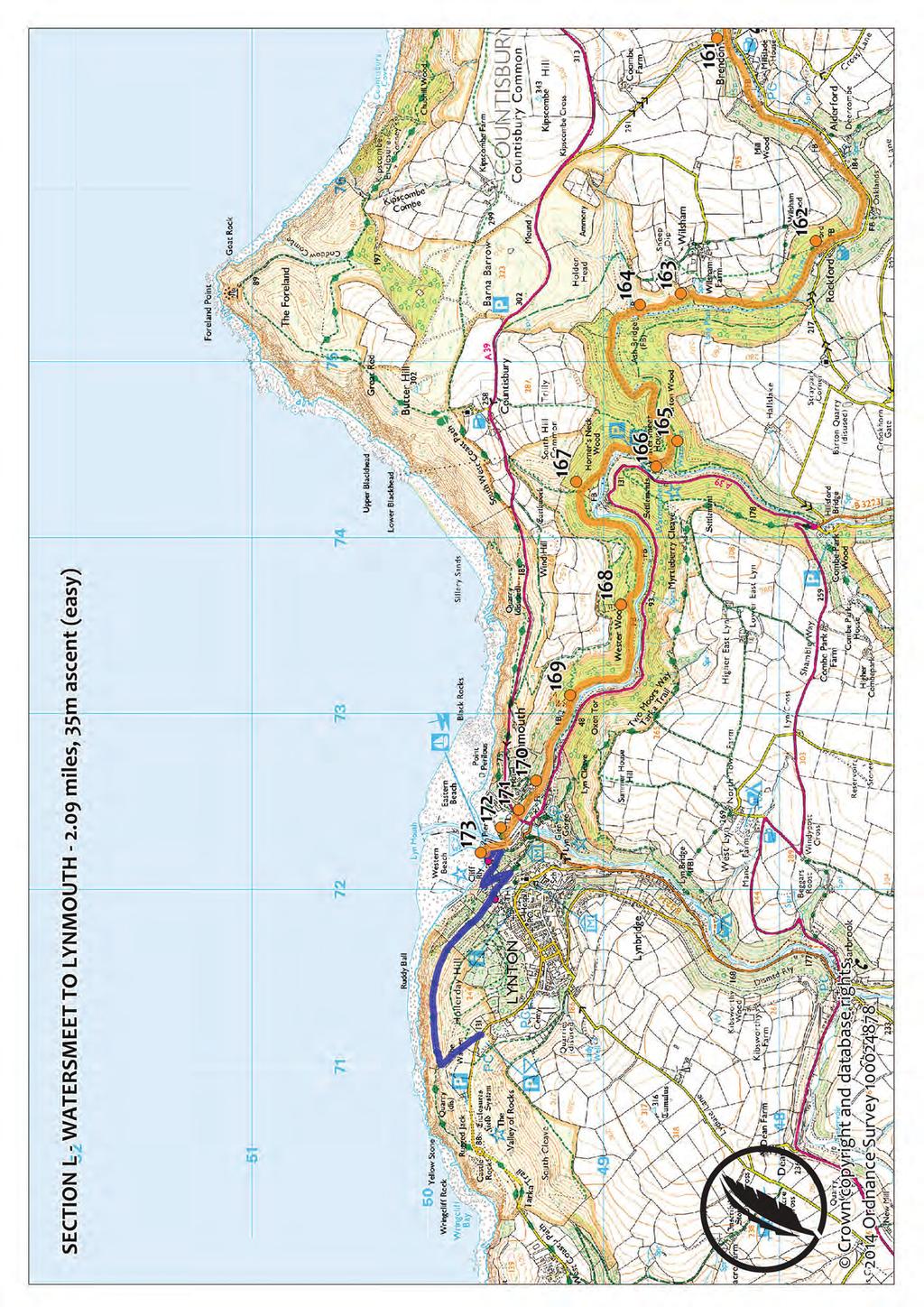
1 L. Lynmouth to Watersmeet Distance: 2 miles Total Ascent: 196 metres Walk Summary: Pavements and quiet road through the village, followed by riverside walk on good surface as you leave Lynmouth. Rough and undulating woodland path through steep-sided valley to Watersmeet with a number of short stretches of ascent and some descent. OPTIONAL ROUTE EXTENSION To get yourself in Romantic mood, start the route at Poets Corner in the Valley of Rocks, walking through stunning scenery to The Pavilion below: From the shelter at Poets Corner take the path towards the coast, carrying on past the right-hand fork up Hollerday Hill to join the South West Coast Path at the end of The Warren. On the Coast Path turn right, following it around the north face of Hollerday Hill, high above the sea. Continue ahead through the trees and on along North Walk, passing the top of the cliff railway to where the Coast Path zigzags downhill, crossing back and forth over the railway to come out through the arch beside The Pavilion. 173 From the Exmoor National Park Centre in the Pavilion, turn right to walk along the Esplanade to the pier. Turn right again, along Riverside Road. 172 Cross the river on the first footbridge, turning right to walk alongside the river to the main A Cross the road to walk straight ahead along Tors Road, bearing right along the riverside footpath a little further ahead. 170 Ignore the footbridge over the river, carrying on along Tors Road and continuing ahead after the car park, when it turns into a footpath through the trees. 169 Carry on past the next footbridge, also ignoring the paths uphill towards Countisbury. The path turns sharply left to follow the river through Wester Wood. Stay on the main path, ignoring smaller paths down to the river and its footbridges. 168 When the path forks, stay on the lower path, still ignoring smaller paths on the right to the river and on the left towards Countisbury. The path curves gently northwards in the lee of Wind Hill and joins another path from Countisbury. 167 Fork right here and carry on through Horner's Neck Wood, following the signs for Watersmeet as the path turns abruptly right and heads southwards around the loop in the river. It is impossible not to be awed by the stunning cliffs and crags in the Valley of Rocks, with their towering spires and pinnacles and the feral goats browsing among them. Look out for the White Lady appearing between the boulders on Castle Rock, and Mother Meldrum in the Devil's Cheesewring but don't be tempted to dance here on a Sunday, or the devil will turn you to stone! The South West Coast Path is a 630-mile long distance walking trail, travelling from Minehead to Poole (in Dorset). Climbing the equivalent of four times up Everest during its transit of the coastal path first trodden by coastguards on the lookout for smugglers, the Coast Path was nonetheless described in Lonely Planet s 'Great Adventures' guide as 'walking at its most diverse, most spectacular and most delicious!' Water is pumped from the river to power the cliff railway, making it the world's only carbon-neutral cliff railway. It was built in 1890 at a cost of 8000, and was part of a large-scale scheme designed to bring Lynmouth and Lynton the commercial success attracted by Minehead and Ilfracombe as a result of their position on the busy Bristol Channel. The scheme also included a pier and a narrow gauge railway link to Barnstaple, and was financed by the district's two wealthy Victorian entrepreneurs, Sir George Newnes and Benjamin Halliday. Newnes was a Derbyshire haberdasher whose magazine, Tit-Bits, made him a vast fortune. He built himself Hollerday House, above Lynmouth, and set himself up as its benefactor. The river's rushing waters played a much more tragic role in Lynmouth's history, when the infamous 1952 Lynmouth Flooding destroyed many of its buildings and left 34 people dead. Watersmeet is noted for its wildlife, and a number of rare trees and plants are found in the ancient oak woodland. Other features among the trees bear witness to an earlier Halliday's industrial endeavours shafts from his fairly futile attempts to mine iron ore, quarries where he obtained the stone for his building work, and limekilns, where he burnt limestone to make fertiliser.
2
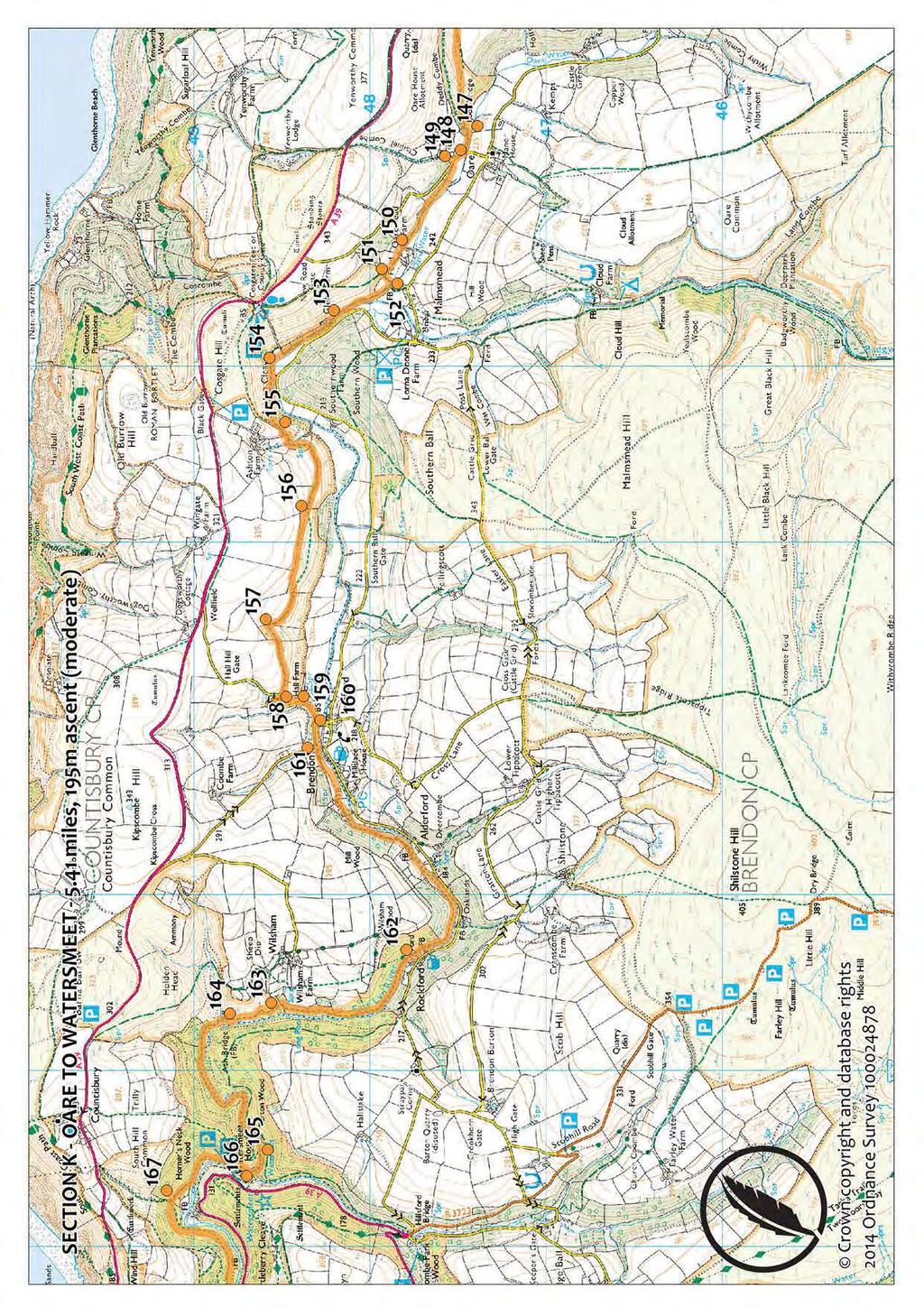
3 K. Watersmeet to Oare Distance: 5½ miles Total Ascent: 359 metres Walk Summary: Undulating riverside path, rough in places, through woodland, then a green lane to Brendon. A steep ascent to a heathland path travelling high above the valley, with great views, then a long descent through woodland to a riverside path beneath towering hills. 166 At Watersmeet House ignore the bridge across the river to carry on along the north bank of the East Lyn River past the meeting of the waters just south of the lodge. 165 Ignore the path to the left towards Countisbury (the 'Church Path') and stay on the riverside path as it makes its way through the trees and turns sharply south with the river. 164 Stay on the eastern bank of the river towards Rockford, crossing a stream joining from the left and ignoring the paths uphill to Countisbury, Wilsham and County Gate. 163 Carry on along the main riverside path below Wilsham Farm, through the trees to the bridge to Rockford. 162 (Note. If the river is very high the path ahead floods and you will need to cross the bridge here and follow the road to Brendon. Cross the road bridge there to rejoin the route.), Otherwise, carry on staying to the North side of the river and continue past Countisbury Mill to come out on the road at Brendon. 161 Turn right on the road and walk past the cobbled bridge to the junction at the road bridge beyond. 160 Unless you want a detour to Brendon, carry on ahead along the smaller road, following it around to the left. 159 Just after Hall Farm a set of wooden steps leads into a field on the right, signed to County Gate and Malmsmead. Go up the steps and into the field, bearing slightly left towards the tree, where a path heads uphill through the bracken. 158 When the path forks, a short distance ahead, turn right and carry on steeply up the hill. 157 Go through the small gate at the top of the hill, descending straight ahead to pass around the top of the wooded combe. The path rounds the next hill. Carry on along the top path when it splits, following the yellow waymarker squares gently uphill to the path's highest point, with magnificent views over the valley below and across Exmoor's hogsback hills. 156 Carry on past the small path joining from the right and go through the gate at the top of the wooden steps. From here the path descends steeply to cross the footbridge below Ashton Farm in another wooded combe. Turn left at the end of the bridge to follow the path around the front of the hill, climbing steeply at first and then beginning to descend to the next junction on the hillside. 155 Fork right here, descending steeply through the trees towards the river. 154 Reaching the gate at the end of the woodland path, cross the field beyond, going through the other gate and out onto the riverside path to walk to Glebe Farm. 153 Go through the gate beside the house, ignoring the bridge on the right to continue ahead along the riverside path to the footbridge about a quarter of a mile ahead. 152 Do not cross the bridge, unless you want a detour to Malmsmead (in which case turn right on the road beyond). Otherwise take the bridleway on the left. 151 At the end of the hedge turn right, following the bridleway across the field. 150 Pass to the left of the buildings at Oaresmead Farm, ignoring the drive on the left beyond them and staying on the bridlepath as it goes through the trees into a field. Stay by the left-hand hedge as far as the gate, turning left here to go out onto the road. 149 On the road turn right, towards Oare, walking past the lane on the right to the bridge beyond. When Halliday, lover of Romantic poetry, built Watersmeet House in 1832, he had lines from a Wordsworth poem inscribed over its doorway: "The spot was made by nature for herself: The travellers know it not, and it will remain Unknown to them; but it is beautiful: And if a man should plant his cottage near, Should sleep beneath the shelter of its trees, And blend its waters with his daily meal, He would so love it, that in his death-hour Its image would survive among his thoughts." Established after 1839, the 'Church Path' linked Countisbury with Rockford. The church at Countisbury was built in the 18th century, but in 1846 the chancel was rebuilt, and the vestry and north aisle added, at Walter Halliday's expense.
4
5 J. Oare to Ash Farm Distance: 4¼ miles Total Ascent: 225 metres Walk Summary: Steep path uphill through heathland then a field; steep descent along quiet country road. Joins South West Coast Path (inland alternative route) along green lane, followed by many ups and downs between several combes on a remote road. 148 Detour ahead to visit Oare Church. Otherwise take the footpath on the left before the bridge and follow it alongside the water to the foot of the hill ahead. 147 Fork right here, following the path directly uphill towards the right-hand hedge. When the hedge bears right and the path forks, leave the hedge to take the left-hand path to the track ahead, in front of the conifer trees. 146 Walk alongside the conifer trees, then bear slightly right and then turn left to follow the track straight ahead to go into the trees at Lilycombe. 145 Turn left on the path just before the private drive and walk to the road. 144 Cross this fast road with care and continue along the small road ahead, descending to the T- junction about three quarters of a mile below, near Broomstreet Farm. 143 Turn right onto the green lane, following the inland (alternative) route of the South West Coast Path into Twitchin Combe. 142 In the combe the lane crosses the stream and turns sharply left, climbing gently before contouring around the hill into Holmer's Combe. 141 Crossing another stream, the lane again doglegs to the left and begins to climb as it rounds the hill, turning into a surfaced road and bearing right as it drops gently to Silcombe Farm. Carry on between the farm buildings, following the road sharply to the left in front of the big barn and walking downhill to where the Coast Path bears left along a track. OPTIONAL DETOUR TO CULBONE CHURCH: Detour left along the South West Coast Path at 140 to visit Culbone Church. After about 400 yards a path leaves on the right, signed to the church. Take this path downhill through the woods, bearing left past the track to carry on beside the stream to the church. Retrace your steps to 140 afterwards and turn left to continue. 140 If you have taken the detour, turn left here to carry on along the Coleridge Way; but if you are continuing from 141 without taking the detour, carry on along the road past the South West Coast Path, heading east from Silcombe Farm. 139 The passes a track on the right, by a caravan, levelling out again in Withy Combe. 138 Ignoring the path uphill to the right, cross the stream and carry on along the road into the last combe on this rollercoaster road. 137 In front of Parsonage Farm the road turns sharply left again and makes its way to Ash Farm, thought to be where Coleridge was famously interrupted by the 'Person From Porlock'. St Beuno's Church at Culbone is England's smallest church still in use, and it was used as the scene of Lorna Doone's dramatic wedding in the TV version of R D Blackmore's novel of the same name. Blackmore himself had the wedding take place in Oare Church, a place he visited frequently as a child, when his grandfather was its Rector. Throughout this district there are the remains of platforms used for charcoal burning in Coleridge's time. Living in a rough hut, a charcoal burner would remove turf nearby to form a shallow pan. He would pile timber around a central post which he then removed to form a chimney, after covering the lot with soil and turf. He would then set light to the 'clamp' the wood beneath which he allowed to smoulder for several days, tending it regularly around the clock. The charcoal was used for smelting and producing tar, and the trees were coppiced to ensure a good supply of wood. Coleridge had expected Kubla Khan to be lines long, but when his muse fled he ended up with just 54 lines. In his preface to the 1816 publication he explained it: 'In the summer of , the Author, then in ill health, had retired to a lonely house between Porlock and Linton... In consequence of a slight indisposition, an anodyne had been prescribed... he continued for about 3 hours in a profound sleep... all the images rose up before him as things On awaking he eagerly wrote down the lines that are here preserved. At this moment he was unfortunately called out by a person on business from Porlock and detained by him above an hour... with the exception of some 8 or 10 scattered lines and images, all the rest had passed away like the images on the surface of a stream into which a stone has been cast.'

6
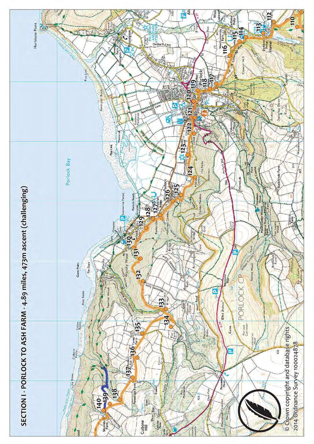
7 I. Ash Farm to Porlock Distance: 4¾ miles Total Ascent: 106 metres Walk Summary: A high lane rollercoastering through a series of combes, with spectacular channel views to Wales. This is followed by a prolonged descent through peaceful woodland, with glimpses through trees to the sea, and a green lane, walking above beach and marshes. 136 Carry on ahead, past Ash Farm, drive and on to the next junction. 135 Continue straight on past the drive to Yarner Farm and the road linking it to the main A39 above. Walking gently downhill, ignore the left-hand fork and continue to the junction. 134 Take the left-hand hairpin, following Pitt Lane a short distance downhill as it becomes the Worthy toll road. 133 Turn right onto the bridleway heading through a gate and into the trees a short distance beyond, at Yearnor Mill Bridge. Fork right a moment later, onto the track, and follow the cycle route downhill, around the edge of the woodland. 132 After about half a mile, a bridleway heads downhill through Worthy Wood. Turn left onto this bridleway and follow it steeply downhill, ignoring the small path that crosses it a little further down. The bridleway curves to the right and comes to a junction with another bridleway. 131 Fork right here (unless you want a detour to Porlock Weir, in which case turn right on the road at the bottom of the hill). Otherwise follow the bridleway as it curves right again, descending gently and bearing right to continue ahead as a smaller path joins from the left. 130 Coming out on the road at a sharp bend, bear left to continue downhill towards Porlock. 129 Carrying on past the small path dropping steeply downhill to your left, stay on the road as it descends gently to a left-hand bend beside a wooden hall. 128 Turn right, beside the hall, to take the bridleway signed to Porlock. 127 Turn left to cross the stream a moment later, bearing left beyond it to climb gently through the trees, ignoring the smaller paths heading steeply uphill. 126 Reaching the lane heading downhill from the right, bear left to carry on ahead along it above West Porlock. It veers to the right and heads uphill, turning left again to drop into a small combe. 125 Ignoring the path heading up the combe to your right, cross the stream to carry on along the lane as it makes its way through the edge of the woodland above the fields that border the marshes. 124 Carry on past the green lane on the left after you cross another stream. 123 Ignoring the small path uphill to your right above Greencombe Gardens, continue along the lane to come out on New Road. 122 Turn left on the road and walk to its junction with Porlock Hill, by the village hall. 121 Turn left again and walk past the Ship Inn to the junction by Porlock Visitor Centre, pop in to enjoy a warm welcome for Coleridge Way walkers, or bear right here to continue along the High Street, towards the church. Ignoring Parson's Street, on the right, walk past the front of St Dubricius Church to The Drang, immediately beyond it. First mentioned in 1292 and once owned by Barlynch priory at Brompton Regis, in 1835 Worthy Manor belonged to Lord William King of Ockham. Marrying Lord Byron's daughter, Ada, Countess of Lovelace, who brought with her a considerable fortune, Lord William set about using her money to improve the estate, 'to make this hermitage worthy of your presence,' he told her. Known in Lady Lovelace's day as Ashley Combe, the 16 th Century mansion was elaborately remodelled and a lavish parkland established. Some 100,000 saplings were brought from Lord Lovelace's estate in Torridon to be planted as deer cover, and Swiss engineers were commissioned to dig tunnels from the house to Lady Lovelace's private beach, so that she could visit it unseen. A regular visitor was Charles Babbage, whose 'difference engine', designed in the 1820s, laid the foundations for modern computers. Lady Ada was a fellow mathematician and wrote an algorithm for the massive machine. Because of this she is often described as the worlds first computer programmer. Before the melting of the ice sheets formed the Bristol Channel after the last Ice Age, 10,000 years ago, there was an extensive forest in Porlock Bay, and at very low tides the fossilised remains of this can be seen on the beach at Porlock Weir. Today the Bristol Channel has the world's second largest tidal range, and in Porlock tides can vary by 12 m.
8
9 H. Porlock to Higher Brockwell Distance: 4¼ miles Total Ascent: 287 metres Walk Summary: Climbing gently through Doverhay, descending through woodland to Horner. A long woodland climb to the viewpoint car park at Webber's Post, descending gently on the Dunster Path around the base of Dunkery Hill to Higher Brockwell. 120 Turn right and walk up The Drang, following it around to the left after the church, and then turning left ahead. Bear right to pass between the thatched cottages, coming out on the road beside Doverhay House. 119 Turn right on the road and walk to the junction a short distance ahead, passing Coach Road on the right, Hawkcombe View on the left and then Orchard Rise on the right. 118 At the junction fork left towards West Luccombe, climbing steeply past Doverhay Knap and carrying on past the bridleway to the right. 117 Crossing the cattle grid to go into the National Trust's Holnicote Estate, carry on over the hill to drop past Luckbarrow Cottage to the road junction beyond. 116 Ignoring the roads to left and right, take the footpath to the right of the road ahead, signed 'Bridle path to Horner'. Carry on past 'Granny's Ride', following the path through the woodland around the foot of Crawter Hill and passing a small gate into the caravan park on the left. 115 The path crosses a small stream at Halse Combe and goes through a gate to travel on above Horner Water. 114 Stay on the path towards Horner, past 'Cat's Scramble to Ley Hill' and over the packhorse bridge to the road. 113 On the road turn right, following it around to the left through the picturesque hamlet of Horner, ignoring both the footpath to Horner Woods on the right and the small path through the village on your left. Passing Horner Mill too, carry on along the road as it climbs steeply and bears right. 112 As you approach the brow of the hill a path goes into the trees on your right. Turn onto this path, signed to Webber's Post and Dunkery Beacon. Ignore Horner Mill Path on your right and carry on along the path through the woods, going through the high gate. When a path leaves on the left to follow the fence along the field, fork right to stay on the higher path, climbing to a junction of paths. 111 Turn right here, on the path signed to Webber's Post and Horner Wood, and walk to the next junction, a short distance ahead. 110 Go straight across 'His Honour's Path', carrying on along the path signed again to Webber's Post and Horner Wood and ignoring the small path heading steeply downhill a moment later. 109 When the path forks again, ignore the Windsor Walk heading towards Horner Wood on your right and instead fork left along the path signed to Webber's Post. The path climbs out of the woods and up onto open heathland. 108 Carry on ahead as a path joins from the left. The route passes the Jubilee Hut (the perfect place for a picnic) and leaves the grassy area to follow a rough track through trees to a lane marked as an easy access trail. 107 Take the bridleway to Webber's Post, signed on the right of the easy access path, and follow it through the trees below the tarmac path. 106 Carry on ahead across the bridleway between Priestway and Stoke Pero, staying on the path to emerge a moment later into the car park at Webber's Post. 105 Cross the near left-hand corner of the car park to the road, following the quill waymarkers to a second road just beyond. 104 Cross this road too, carrying straight on through the small area of rough ground to pick up the footpath on the right. The path ascends gently to a T-junction above. 103 Turn left, taking the path signed to Wootton Courtenay (the Dunster Path). Ignore the smaller paths through the bracken and stay on this path as it descends through an area of open moorland on the lower slopes of Dunkery Hill. After about a mile, two bridleways leave on the left, marked with blue squares, and your path forks. 102 Ignoring the bridleway left to Brockwell, bear right to continue on the Dunster Path as it descends into woodland at Higher Brockwell. The Drang is thought to be a medieval path. Fronting it, opposite the church, the fifteenth-century Chantry Cottage was the two-cell residence of the chaplains of the church. First appointed in 1476, the chaplains had to provide 'bread and cheese and ten gallons of good beer to be eaten and drunk in memory of the Lord and Lady after the anniversary service'.

10
11 G. Brockwell to Cutcombe Distance: 4 miles Total Ascent: 359 metres Walk Summary: Strenuous moorland route, exposed and remote from Higher Brockwell. Long, steep climb on rugged paths, streams to cross. Stay by left-hand boundary from 99 to 95. Woodland paths to hotel drive at Raleigh Manor. Field path to Cutcombe may be muddy. 101 At the crossroads in the woods at Higher Brockwell, turn right on the bridleway to Dunkery Beacon, climbing to the edge of the wood. 100 Fork left here, leaving the bridleway to Dunkery Beacon and instead following the one signed to Elsworthy. This follows a rough track steeply uphill to where a path joins from the left at the edge of the open moor. 99 Bear right to follow the boundary bank around the corner and then steeply downhill to ford the stream in Hanny Combe. On the far side, the path climbs steeply round the side of the hill and forks. 98 Take the right fork, signed to Spangate, still ascending steeply along the edge of the moor to the junction of paths ahead. 97 Stay by the hedge as the path turns left along it and starts to descend. 96 Reaching the opening at a right-hand corner, about 200 yards ahead, do not go through, but bear right with the hedge, ascending slightly before taking the sharp left-hand turn with it and descending abruptly into the woods below. Carry on straight on ahead through the trees, ignoring the tracks to right and left, until you come to the River Avill, at the bottom of the hill. 95 Cross the river to continue along the path above it. Ignoring the track on the left, carry on through the trees around the bottom of the hill, until the path forks in front of a small tributary flowing in from the right. 94 Fork right onto the bridleway heading uphill, crossing the small stream and climbing steeply into Blagdon Wood. In the wood bear right with the path to another junction of paths. 93 Fork left onto the bridleway to Wheddon Cross and follow it through the wood, carrying on ahead when a small path crosses it. Follow the blue squares through the trees to go through a gate and drop steeply to a small stream. Climbing on the far side, the path goes through another gate and crosses a field before passing through more woodland to the road at Drapers Way. 92 Cross the road and take 'Tom's Path' opposite, following the quill waymarkers through Little Quarme Wood towards Wheddon Cross, forking left on the lower path at the first junction. 91 Bear right at the T-junction to pass in front of Raleigh Manor. Go through the gate and follow the hedge around the edge of the lawn to come out on the drive. 90 Turn left here on the bridleway to Cutcombe and follow the drive towards the road. 89 Ignore the path to the right after the cattle grid, (unless you want a detour to Wheddon Cross), and carry on along the drive to the main road ahead. 88 Cross the road to take the bridleway through the field immediately opposite. Follow the left-hand hedge to the green lane beyond, carrying on along it to come out on the road through Cutcombe. Much of the bedrock beneath the Coleridge Way was laid down during the Devonian period, a little under 400 million years ago, and consists of sandstones, grits and slates, with some limestone. Around Brockwell this was overlaid by sandstones in the Triassic period, more than 100 million years later, giving rise to deposits of iron. From Roman times, or earlier, 'bell-pits' had been dug on Exmoor to exploit its iron ore, and a geologist's report from 1826 refers to trial pits that were dug at Brockwell, leading to opencast mines being worked here by Welsh miners in the next couple of decades. In 1848 a Cornish miner living in Dunster leased the mine to continue the extraction of the ore; but by the end of the nineteenth century the mine had been worked out and it was abandoned. Wheddon Cross is famed for its 'Snowdrop Valley', where the woodland floor in a particular valley on the River Avill is carpeted with snowdrops in February. Throughout the month, Exmoor National Park and various Cutcombe bodies together run a park and ride service to the valley, staff the Snowdrop Information Point in the village car park and man the Snowdrop Valley Café in the Moorland Hall. Leaflets give details of local walking routes, which are very popular at this time of year. As a consequence, footpaths in this area are often very muddy during February!

12
13 F. Cutcombe to Luxborough Distance: 4¾ miles Total Ascent: 134 metres Walk Summary: Ascending Lype Hill via a slippery lane (beware!) and field footpaths, the route descends on the other side via a holloway and a steep farm track. From the level farm drive, it follows quiet roads through the Luxborough hamlets of Pooltown and Kingsbridge. 87 In Cutcombe bear left on the road and walk along Higher Park Lane to the junction. 86 Detour ahead to visit St John's Church; but otherwise turn sharply right onto Lower Park Lane and walk to Cutcombe Cross, where Popery Lane leads to Wheddon Cross on the right, and a restricted byway heads towards Luxborough on the left. 85 Carry straight on ahead, up the concrete lane, climbing past Cross Cottage. Take care on this stretch of path, as the rock surface is very slippery, especially when wet. Continue along the green lane uphill to the gate at the top. 84 Go through the gate into the field and follow the path along the left-hand hedge of this field and the next one. Ignoring the footpath across the second field, go through the gate in the far left-hand corner, following the blue squares, and take the green lane alongside the fields to Pitleigh. 83 Carry on past the buildings, ignoring the footpath to the right, and take the bridleway through two gates separated by a short lane and into the field. Stay by the right-hand hedge through the field, following blue squares, and go through the gate to follow the left-hand fence to the top of the next field. Going through this gate, stay by the left-hand fence until you come to the gate about 200 yards up. 82 Go through the gate, turning right and then bearing diagonally left to the gate to the left of the trees at the top. Going through the gate, cross the next field to the top hedge, bearing left to walk to the gate out onto the road. Note that the route on the Ordnance Survey map does not reflect the route as waymarked over Lype Hill. Head due east from here to 79, keeping an eye open for Coleridge Way quills and blue squares. 81 Cross the road and take the bridleway signed to Luxborough into the field opposite. Heading due east, bear left ahead to the gate in the fence at the far end of the field. Carry on in the same direction in the next field, aiming to the left of the barrow on the summit of Lype Hill. 80 Going through the gate beside the mound, keep pointing east as you bear left ahead to go through the gate into the next field. Walk directly across the field to go through the fence opposite, taking the gate in the far left-hand corner of the next field, marked with a quill and a blue square. Keep the fence to your right, bearing left at the end of it to where the last field narrows to a point at its easternmost extremity. 79 Go through the small gate on your left, finally leaving the easterly bearing to follow the holloway downhill beneath an avenue of beech trees. 78 At the end of the beech avenue, go through the gate to take the track on your right, bearing left when it forks and continuing steeply downhill beside the boundary bank. 77 Carry on ahead along the track when a bridleway joins from the left. Pass to the left of the farm buildings at the bottom of the hill and ignore the footpath to the right and left. Stay on the drive for about half a mile, ignoring another footpath to the right at the end and carrying on to the Pooltown- Churchtown road ahead. 76 Turn right on the road, walking downhill past Chargot House. 75 Carry on ahead when a road merges from below, to the right, and walk past Hall Farm to the junction at Pooltown. 74 Turn left to continue in the same direction along the road signed towards Roadwater and Washford. Stay on the road past the footpath on the left by the stream, walking along the road to the village hall in Kingsbridge. In the Moorland Hall at Wheddon Cross is a stained glass window depicting a line from Coleridge's poem 'Frost at Midnight': 'Therefore all seasons shall be sweet to thee'. Coleridge wrote the poem in February 1798, when he was living in Nether Stowey. The month before, his small son Hartley had fallen and hurt himself. 'I caught him up, crying and screaming, and ran out of doors with him,' said the poet. 'The moon caught his eye he ceased crying immediately and his eyes and the tears in them how they glittered in the moonlight!' The bowl barrow on the summit of Lype Hill dates from the Bronze Age. Beneath the turf it is ringed by a kerb of quartz stones, thought to be original.

14

15 E. Luxborough to Roadwater Distance: 3¼ miles Total Ascent: 101 metres Walk Summary: A long but gentle climb along a lane and then a footpath through fields, to a high viewpoint. A steep descent through more fields, then an easier drop through woodland. Level road to Roadwater through a wooded valley shaded by steep hills. 73 In Kingsbridge (Luxborough) take the sharp righthand turn opposite the village hall to follow the lane uphill between the houses. Stay on the lane to the gate at the end, carrying straight on ahead along the hedge in the last field to pick up another lane towards the farm buildings. 72 Carry on past the farm buildings and straight across the field ahead to follow the path along the right-hand hedge of the next two fields. In the next field bear right to pass between the trees, heading for the road to Treborough. 71 Do not go out onto the road, but go through the gap in the hedge and turn left behind it into the next field. Follow the left-hand boundary downhill through several fields to the track leading through Langridge Wood, below. 70 When the track forks, take the right-hand path, signed to Tacker Street. 69 About 150 yards along the track, the Langridge Wood cist is signed to the right. From here carry straight on along the track downhill through the wood, continuing ahead along the main path, marked with a quill, when a smaller path leaves on the left and then a track heads away to the right. 68 Reaching the road at the bottom of the woodland, turn right, crossing the stream and carrying on past both Treborough Cottage and the footpath beside it. Continue along the road above the fishery, ignoring the footpaths to left and right beyond it and walking to the junction. 67 Bear left to carry on ahead along the road into Roadwater, passing the Valiant Soldier pub and ignoring the footpath to the right beyond it. At Felons Oak, signposted left as you come out of Langridge Wood, a mammoth oak tree had the same grisly function as Walford's Gibbet, ahead above Nether Stowey. Felons sentenced to death were hung in the tree on a particularly strong rope and left there to die. They remained suspended, as an example, until the rope broke and their bodies fell to the track. In Coleridge's day, Bridgwater Assizes was pursuing a 'zero tolerance' policy towards what was considered the rampant lawlessness in the area. Petty thieves were whipped and even deported, while horse-stealers were sentenced to death. Long-term suspension of a decomposing corpse was used as a grim deterrent, with the public encouraged to participate in the ritual. There are records of group executions at Ilchester Gaol being celebrated with rowdy 'Hanging Fairs'. Locals claimed that dark powers enveloped Felons Oak as a result of its gruesome history, and if you visited after nightfall your own neck would start to tingle ominously. When the oak was finally felled, after standing there for more than 300 years, the rumour was that if you put your ear to its stump you would hear the rattle of chains. The Langridge Wood Bronze Age cist, orientated from east to west, is lined with slate slabs. The large slab laid across it was once its capstone, and the whole was originally covered in a mound of earth and stone. Much of the material from it was removed in the nineteenth century for road-building, revealing a skeleton buried inside. This was subsequently re-interred in Treborough churchyard.

16
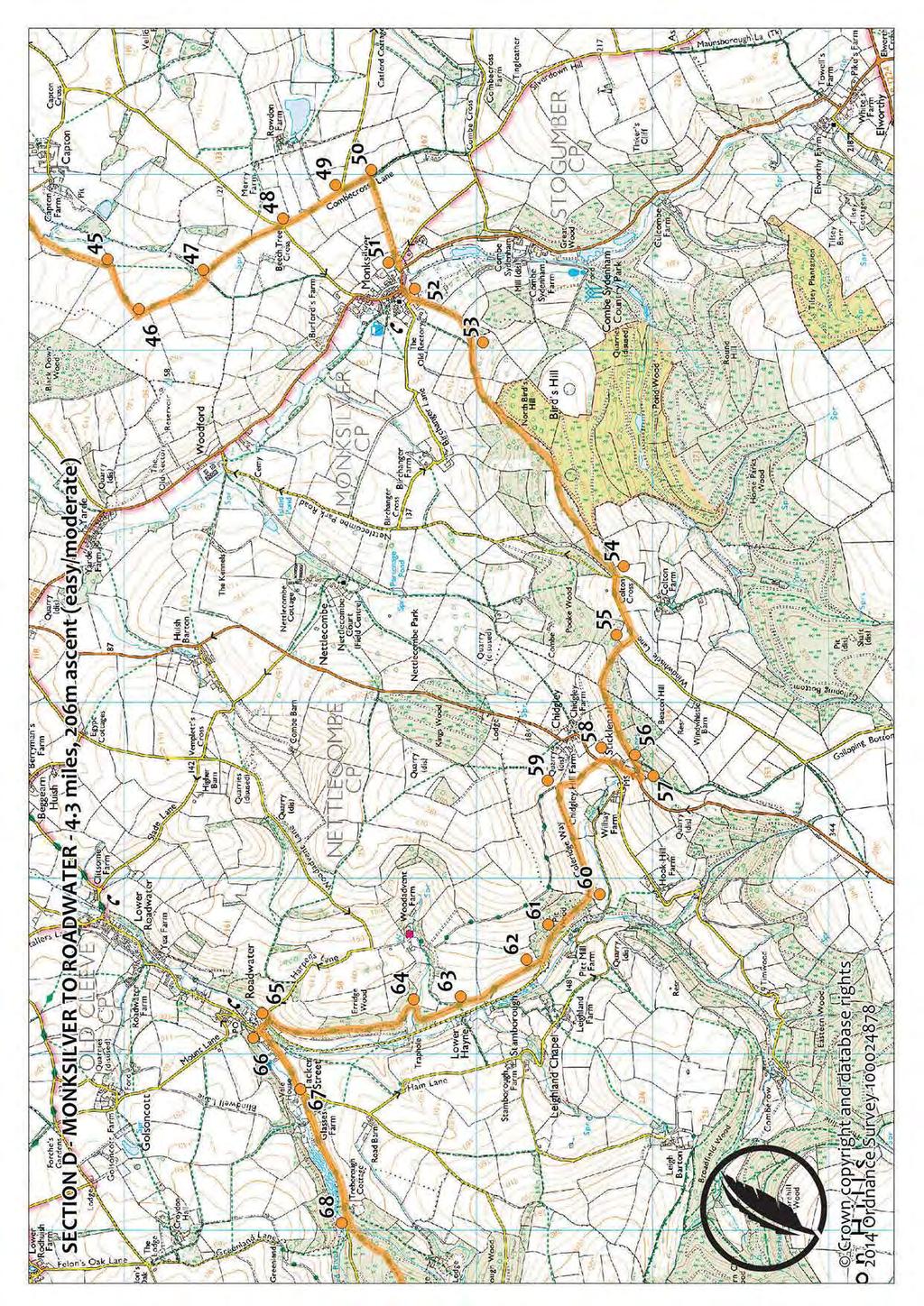
17 D. Roadwater to Monksilver Distance: 4¼ miles Total Ascent: 233 metres Walk Summary: From the ancient and picturesque Roadwater the path climbs gently through fields and woodland, to follow a level path above the Washford River. Old lanes follow a steep ascent of Beacon Hill and a subsequent steep descent of Bird's Hill into Monksilver. 66 Just before you reach Watersmeet Close in Roadwater, a narrow lane heads away to the right (Harper's Lane). Turn right onto it, passing between several interesting old buildings and crossing the stream. Carry on past the West Somerset Mineral Railway Line signed along the 'no through road' to Harper's Cottage, a short distance uphill. 65 Turn right on the bridleway opposite the cottage, signed to Stickle Path. Go through the gate to follow the green lane uphill, across a field and through another gate into Erridge Wood. 64 After about half a mile the path turns left and then passes through a small gate on the right into a field. Cross the stream and go through another gate, walking through woodland again for a short distance before emerging in a field above Lower Hayne. 63 Follow the bridleway along the fence, ignoring the footpath that crosses it and another one to the right a little further on. 62 Travelling alongside a stone wall topped with beeches, the path passes beneath fields and then enters Pit Wood through a little gate. 61 Ignore the footpath to the right, signed to the Mineral Line, and make your way through Pit Wood, continuing ahead when another path merges from the left. 60 Go through the gate in the far boundary, emerging once more above an open landscape. Follow the track around to the left beside the beech boundary, carrying on at the end of the field to the gate opening onto a lane. 59 Turn right immediately after going through the gate, following the lane up to the main road. 58 Turn right on the road and walk smartly uphill, listening carefully for approaching traffic all the while. (The sharp bends in both directions greatly limit drivers' visibility, and there is no pavement). Passing a minor road on your right, follow the road around the left-hand bend to a lane on the left beyond it. 57 Turn left on the lane, where a bridleway is signed towards Monksilver and Ralegh's Cross. 56 Fork left on the track signed to Monksilver via Colton Cross a little way ahead and follow it up the side of Beacon Hill. Ignoring the track that crosses your path towards the top of the hill, carry on ahead to go through the gate, walking straight across the field beyond to come out on Windwhistle Lane. 55 Turn left on the road. Ignore the permitted path on the left (unless you want a detour to the viewpoint) and walk to the junction at Colton Cross. 54 Ignore a road to the left and a road and a lane to the right, and carry straight on along the track ahead, going through the gate to follow the bridleway into the woods. Keeping an eye open for blue squares, carry on through the woods, forking right towards Monksilver when you come to the waymarker half a mile ahead. The path steadily descends on the northwestern flank of Bird's Hill, continuing between fields when it comes out of the woods. 53 Carry on along the lane when a path crosses the field to your left towards the bottom. After a couple of small waterfalls a tiny stream appears and travels alongside the path as it descends into Monksilver. Throughout Exmoor National Park, beech-topped boundary banks like the one alongside the path to Chidgley are a distinctive and important part of the landscape. These are unusual features both nationally and internationally, being confined to Somerset, Devon and Cornwall. Some of Exmoor's banks are thousands of years old, and the massive beech trees along them are the result of neglected hedges, planted as wind-breaks and used to contain stock as well as form boundaries. The ancient hedges provide important habitats for wildlife, where birds, wasps and bees can nest and bats can roost. The banks are good for insects and plants, and burrowing mammals such as voles. Stone boundaries are rarer on the moor; but the many cornditches are being restored in agroenvironmental schemes. The vertical stone wall of these boundary banks is backed by a sloping side, providing one-way access for livestock on the moor. In the nineteenth-century the Acland family of Holnicote planted many beeches on their boundaries, having noted that they were of less use as logs and so were raided less by the locals; and the Knight family of Simonsbath used them extensively in their moorland reclamation project.
18
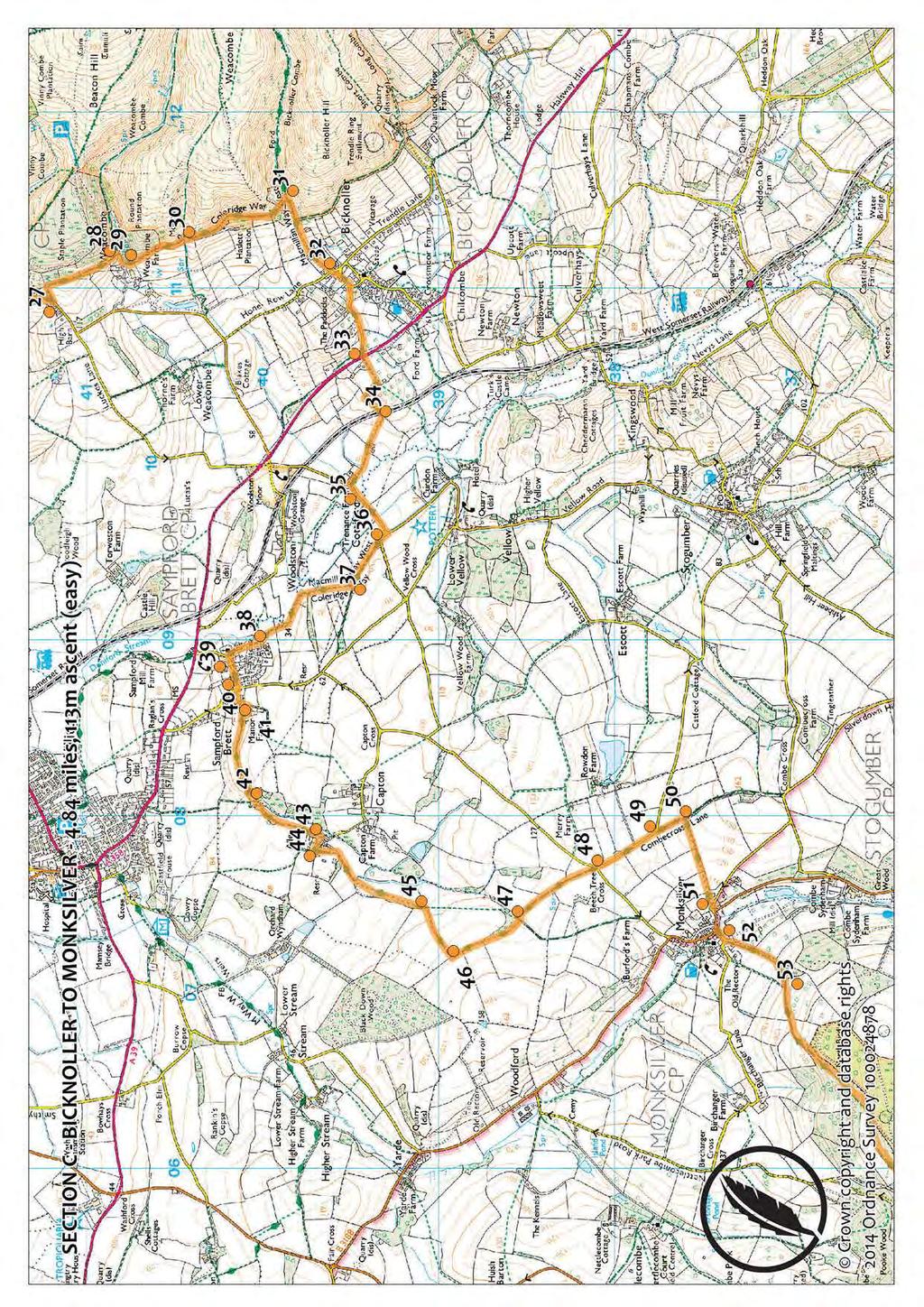
19 C. Monksilver to Bicknoller Distance: 4¾ miles Total Ascent: 105 metres Walk Summary: From Monksilver a field footpath leads to an ancient lane before more fields and a descent into Sampford Brett. Another lane, field and farm track, a quiet road and fields before crossing the West Somerset Railway line and the main A358 road. A quiet road into Bicknoller. 52 Coming out on the road, opposite some thatched cottages, turn right and descend to the junction on the main road through Monksilver. Detour left to visit the pub, but otherwise bear right to carry on ahead, past a lane on the left, to the next junction. 51 Turn left onto the road signed to Stogumber, turning left again immediately into the gateway by the junction, where a quill points the way into the field. Follow the footpath alongside the right-hand hedge of four fields, climbing gently, to where it drops down a set of steps into a holloway known as Combecross Lane. 50 Turn left and follow the lane a couple of hundred yards to the road. 49 Bear left to carry straight on along the road to the junction at Beech Tree Cross. 48 Bear slightly right to carry straight on ahead, following a continuation of the green lane to a junction of paths by a field. 47 Turn left, almost immediately turning off the lane to follow the waymarker into the field on the right. After the gateway bear right to follow the hedge, carrying straight on through the next field to where the track turns right into the field below. 46 Turn right with the track, descending steeply to bear left along the bottom hedge, through the gap into the next field. 45 Turn left immediately, still on the track, following it around the left-hand hedge, ignoring the track that joins from the right at the end of the field. Continue along the lane ahead, forking left at the end to pass in front of the barns. 44 After the barns, turn right to follow the drive downhill past the Elizabethan farmhouse at Aller Farm. 43 As the drive turns to the right, a footpath leaves through a small gate on the left beyond the stables. Take this footpath through the trees, crossing a footbridge to go into the woods. 42 When the path forks after the bridge, take the right-hand path, descending to a small gate, where the path becomes a lane between fields. At the end of the lane turn right and cross the footbridge, going through another small gate to continue along the lane beside the field. Stay on the path as it curves to the right and then the left and goes through a metal gate into the farmyard at Manor Farm. Go straight across the farmyard to the road. 41 On the road turn left to walk into Sampford Brett. 40 At the next junction turn right and then left, heading towards the church. 39 Turn right in front of the church and walk to the right-hand bend about 100 yards ahead. 38 Carry straight on ahead along the lane. Going into the field, ignore the footpath on the left, instead following the track around to the right. It becomes a lane again and makes its way alongside the Doniford Stream and into woodland. Coming out of the trees, head straight across the field to the gate by the pylon, coming out on a farm track. 37 Turn left on the track and walk past some barns to the road, bearing left to the junction. 36 Take the road left, signed to Williton and Bicknoller, crossing the bridge and walking to the thatched cottage (Badgers Rake) at Cottiford. 35 Turn right before the cottage to take the track towards the farm, going into the field on the left and following the right-hand hedge around the farm and through the field beyond, to where it comes out on the West Somerset Railwayline. 34 Cross the line, listening out for trains, and carry on along the green lane, bearing right and then turning left to walk along the lane to the main road. 33 Cross the road carefully to continue along the minor road signed to Bicknoller. Carry on along Dashwoods Lane, continuing past Combe Close on your right. Detour right along Gatchells Lane to visit the twelfth-century Church of St George; but otherwise carry on along Dashwoods Lane, bearing left when it forks by Combe Barn. Bicknoller Hill has been an important place for local residents since prehistoric times. Stone Age flint scatters have been found on its slopes, and there are many cairns and bowl barrows from the Bronze Age, up to 4000 years ago. To the south east as the Coleridge Way starts to head north is Trendle Ring, an Iron Age hillfort with a mystery. Although it is impressively sited above the valley, its position is not easily defended and its slopes too steep to enclose stock, leaving archaeologists wondering what its true purpose was.
20
21 B. Bicknoller to Alfoxton Distance: 5 miles Total Ascent: 276 metres Walk Summary: Leaves Bicknoller on a woodland path beneath heathland, continues through plantation into West Quantoxhead. Climbs out onto a grassy track around Deer Park and undulates across low rim of high heathland. Climbs over hill, descends to Alfoxton House. 32 Reaching Honey Row Lane, beyond Bicknoller village hall, turn left for the village shop, but otherwise cross the road and carry straight on ahead along Hill Lane, ignoring the bridleway to the right (unless you want a detour to the Trendle Ring Iron Age hillfort). Going through the gate, carry on along the lane into the National Trust property at Bicknoller Hill. 31 In the woods leave the Macmillan Way West, instead following the path to the left as indicated by the quill waymarker. Crossing the tiny stream, the path climbs steeply uphill beside an earthen bank which sometimes becomes a stone wall as you contour along the bottom of the hill. 30 When a bridleway crosses your path as it heads downhill, bear slightly left to carry on along the path ahead through the woods until it drops steeply to a gate. 29 Go through the gate to cross the stream, turning right in front of the house and going through the gate to follow the track uphill for about 100 yards. 28 Go through the gate on the left to take the path through the woods, carrying on ahead when another path merges from the right. After about a quarter of a mile the path turns left, going through a gate and descending past Pitt Cottage to the road below. 27 On the road turn right and walk to the crossroads a quarter of a mile ahead. 26 Ignoring the road to Williton and Minehead, on the left, and Staple Plain, on the right, carry on along The Avenue, signed to Kilve and Bridgwater. 25 Reaching the main road at the end of The Avenue, detour left for the shop in West Quantoxhead, but otherwise turn right to pick up the footpath behind the hedge to the bottom of the hill. 24 As the footpath returns you to the road, opposite the church, a lane leaves on your right, heading uphill past the Old Rectory. Turn right on this lane and follow it uphill for about 200 yards. 23 Take the path signed on the left through the gate, following it around the edge of the Deer Park above West Quantoxhead. 22 The grassy path descends towards a layby on the main road. Do not go through the gate, but carry on ahead along the track signed to East Quantoxhead, taking the small path into the trees on the left a moment later. The path snakes through the woods, going through a small gate just above the road. 21 Ignoring the bridleway down to the road, continue alongside the hedge around the bottom of the hillside. 20 Ignore another bridleway heading down a green lane to the left, towards the road. Instead follow the track around to the right, ignoring the bridleway heading uphill to the right just before your track turns left. Passing beneath the clumps of trees at Smith's Knap, carry on beside the fence to descend sharply to Smith's Combe. 19 Crossing both streams on the footbridges, carry on past the bridleway linking Smith's Combe to the main road, instead following the path signed ahead to Holford, climbing steeply into open heathland. 18 Just 200 yards further on, another bridleway crosses your path to head downhill to the road. Carry on past this one too, still following the signs to Holford as the path levels out and rollercoasters around the bottom of the hill, crossing some streams and going into woodland. Carry on past a bridleway that climbs to the right and follow the path along the fence to where it meets a rough track. 17 Turn right on the track, (Pardlestone Lane), heading steeply uphill past a cottage and onto a surfaced lane. Passing a couple more houses, you come to a junction with a couple of tracks heading away to your left. Ignoring both, bear left on the surfaced lane. Carry on around the sharp right-hand bend, passing a track joining from the left and then a bridleway on the right. 16 Ignore the bridleway and take the sharp left-hand bend, following the lane downhill to Alfoxton. Carry on over the cattle grid, passing between the big house and its various outbuildings. Ignoring the drive merging from the right, carry on along the main drive to another cattle grid. In Perry there is a derelict farmhouse from the late seventeenth century, but there was a village here as early as the 1400s. Divided into Higher and Lower Perry, the village was abandoned when the lane linking it to West Quantoxhead became defunct. There are still medieval field systems in the area, and the enclosures at Perry Combe, where the hedges have grown to trees.

22
23 A. Alfoxton to Nether Stowey Distance: 4¾ miles Total Ascent: 181 metres Walk Summary: Tarmac drive then quiet roads through Holford. A long climb to the top of Woodlands Hill, over moorland and into woodland. Quiet roads, a lane and steep descent to Nether Stowey. Much of this section also follows a route signed the Quantock Greenway. 15 Ignore the footpath on the right and the bridleway on the left. Continue along the main Alfoxton drive as it curves through the trees for about half a mile, passing another drive joining from the right. Carry on past a small footpath on the left a little later, and continue between the gateposts to the Dog Pound on the right as you leave Alfoxton Park. 14 Stay on the road as it turns abruptly left. Ignore the unclassified road on the corner as it does, and the bridleway signed to Hodder's Combe by the car park at Holford Bowling Green. Carrying on past another bridleway on the right shortly afterwards, follow the road around to the right and cross the bridge. On the left-hand bend ahead, walk past the private drive and then take the lane on the right, heading uphill beside the thatched cottages (unless you want a detour to the church, along the road to the left before the lane). 13 At the top of the lane cross the road to carry straight on ahead along the left-hand side of The Triangle. Bear left with the road, climbing steeply for a short distance and then dropping again towards a layby at the side of the main A39 road. 12 Turn right on the track beside the National Trust Woodlands Hill sign, going through the gate and following the track uphill through the woods. 11 Carry on ahead when a path joins from the left, and keep going past the gate on the right, which leads to another track. Continue ahead after the pond, still climbing through the wood, until you come out of the trees onto open heathland. 10 When the track splits into two, take the righthand track, climbing steadily past the summit cairn, carrying on ahead as the path levels out. When the track splits into two again, ignore the bridleway that descends into Holford Combe, to the right. Instead, take the left-hand (higher) track, which continues to ascend and then starts to curve to the left. 9 At the four-way junction take the left-hand path, which levels out and heads eastwards, towards the trees. 8 Unless you want a detour to the Dowsborough Iron Age Hillfort at the top of the hill, ignore the steep track to the right and carry on along the path through the trees. Keep going ahead when another, smaller, path heads up towards the hillfort. Continue along the lane to come out on the road. 7 Turn left on the road and walk to the sharp lefthand bend about half a mile ahead, at Walford's Gibbet. 6 Turn right through the gate on the bend, going through into the field and descending steeply alongside the right-hand hedge, passing to the right of a quarry pit. 5 Going through the gate at the bottom of the field, turn sharply right and follow the lane downhill to the crossroads by the cottage. 4 Take the left-hand path, in front of the cottage, and follow the lane alongside the stream for about half a mile, coming out on the road. 3 Turn left on the road, turning right at the junction a moment later to walk uphill towards the site of what was once Nether Stowey Castle. Passing Hockpitts Lane on the right, carry on past the footpath on the left (unless you want a detour to the castle site). 2 Walk down Castle Street, past Thomas Poole's tannery, and the Globe, where the condemned murderer Walford drank his last pint of cider, to the T-junction at the clock tower. 1 Turn left along Lime Street, reaching journey's end at Coleridge Cottage, on the left. The Iron Age hillfort at Dowsborough shares its site with a Bronze Age bowl barrow. Dating from between the 4th century BC and the 1st century AD, with impressive views, the hillfort was surrounded by a single massive rampart. The quarry pit was associated with a small copper mine at Dodington which operated sporadically until 1822, with a counting house nearby. Prospecting pits and shafts littered Woodlands Hill, with two engine houses near the road. Castle Hill was once known as St Michael's Hill after the 1154 chapel built on the site of Nether Stowey Castle. Nearby were a medieval kiln and a later corn mill. The motte and bailey castle was built sometime before the chapel, on the site of an earlier fort developed during the 11th century, and it is thought to have replaced an even earlier castle in Over Stowey.

24
Beautiful Walks from the Blue Ball Inn
 Walk No. 5 RIVER VALLEYS AND MOOR Countisbury, Watersmeet, Hillsford Bridge, Cheriton, Shilstone Hill, Rockford and Chiselcombe. 8.5 MILES APPROX. Walking time four and a half hours approx. OS 1;25,000
Beautiful Walks from the Blue Ball Inn
 Walk No. 2 WINSTONS WALK Countisbury, Wind Hill, Watersmeet, Ash Bridge and Winston s path. 5 Miles approx. Walking time- Two and a half hours approx. (Not including Breaks) OS 1:25,000 Sheet 64/74 Lynton
CWMGIEDD FROM ABERCRAVE
 Abercrave to Cwmgiedd Walk Page 1 Starting from The Abercrave Inn. Grid Ref: SN 824128 From the Abercrave Inn, an 11.3km (7 miles) walk to the foothills of the Cribarth Mountain, then through forest to
Leaden Boot Challenge ROUTE INSTRUCTIONS
 Leaden Boot Challenge ROUTE INSTRUCTIONS Section 1 Alstonefield to Ilam From the village hall car park turn R then L and pass through the village keeping to the R to enter Church Street. Pass the Church
Leaden Boot Challenge 2016 ROUTE INSTRUCTIONS
 Leaden Boot Challenge 2016 ROUTE INSTRUCTIONS Section 1 Alstonefield to Ilam (CP2) From the village hall car park turn R then L and pass through the village keeping to the R to enter Church Street. Pass
Pontfadog. Walk A. Walk A
 Walk A A Bird s eye view of the village 2km. (1 1 /2 miles); height gain 45m. (150ft) about 45 minutes. Six minutes walk along the main road towards Glyn Ceiriog reach a signpost to Llwynmawr. Take the
The Mendip Way. Route Directions and Maps Uphill to Wells
 The Mendip Way Route Directions and Maps Uphill to Wells Website: www.mendiphillsaonb.org.uk Email: mendip@mendiphillsaonb.org.uk Facebook & Twitter: @MendipHillsAONB Phone: 01761462338 1 Uphill to Loxton
Slad over to Pitchcombe and back
 The walk climbs up from Slad over Wickridge Hill, descends to near Pitchcombe, then climbs back over Wickridge hill and round the back of Slad. Page 1 Start Point: SO 8718 0732 The Woolpack, Slad Length:
BISHOPSTONE CIRCULAR WALK
 BISHOPSTONE CIRCULAR WALK 4½ miles (7¼ km) - allow 2 hours (see maps on final pages) Introduction This walk is within the North Wessex Downs Area of Outstanding Natural Beauty and starts from the small,
Bewl Water & the High Weald
 1 Bewl Water & the High Weald Stonegate station - Stonegate - Wallcrouch - Newbarn - Cousley Wood - Wood's Green - Wadhurst station Length: 9 ½ miles (15.3km) Underfoot: Large portions of this path are
HARDMOORS 55 RACE ROUTE 2018 HELMSLEY - GUISBOROUGH
 HARDMOORS 55 RACE ROUTE 2018 HELMSLEY - GUISBOROUGH HELMSLEY - CHECKPOINT 1 (WHITE HORSE) 1. Leave RACE START, continue ahead on road (Baxtons Sprunt) At crossroads turn right down Canons Garth eventualy
Hindhead, Keffolds Copse and Gibbet Hill
 point your feet on a new path, Keffolds Copse and Gibbet Hill Distance: 6 km=4 miles Region: Surrey Author: Schwebefuss Refreshments: Punch Bowl Café moderate walking Date written: 14-apr-2015 Last update:
Ystwyth and Rheidol Bridleway Routes. Route 2:Llanilar Circular
 Ystwyth and Rheidol Bridleway Routes Route 2:Llanilar Circular Route overview and terrain: A long circle using connecting ridges with fine views to link the Rheidol and Ystwyth river valleys. The route
Woodland Walk If you enjoyed this walk there are two others available in the same area.
 The Woodland Walk 11-12 kilometres (7-8 miles) 4-5 hours Terrain: some easy hills Can be slippery when wet 5 stiles Unsuitable for a pushchair/wheelchair Uses OS map 197 Parking: Pulborough Station and
Walk 1. Cotswold Water Park. Gateway Centre to Cerney Wick, railway track to Lake 6, Gateway Centre.
 Cotswold Water ark Walk way A Swindon/ Cirencester Thomas and Severn Canal way to Cerney Wick, railway track to Lake, way. Spine Road East Hotel Time: hours (short walk km) Distance: km A level walk along
Pen Cerrig-calch prehistoric cairns
 Walk Information: Maps: OS Explorer OL13 Distance: 8 miles / 13 kilometres Duration: Allow at least 6 hours for the circular walk Difficulty: medium. Some narrow paths, occasionally rough underfoot Start
BURGHCLERE PARISH RIGHTS OF WAY
 BURGHCLERE PARISH RIGHTS OF WAY Full descriptions compiled by Neill & Miggie Bruce All photos Miggie Bruce FP23 on Ridgemoor, looking south, with FP22 crossing by the bush FP1. From C183 Aldern Bridge
Sponsored by. statestreet.com
 /STATESTREETISLANDWALK #ISLANDWALKJSY Sponsored by statestreet.com Important Information If you forget everything else PLEASE remember the following.» Remember to check OUT of every checkpoint» If you
Aeron & Arth walks 4 walks for all the family to enjoy
 Aeron & Arth walks walks for all the family to enjoy Please take note that the maps illustrating these walks are intended as a rough guide only. You should use the most recent version of the relevant Ordnance
Beamers Trail. Walk No.1. 6 miles. (easy with some moderate ascents and descents)
") Beamers Trail Walk No.1 6 miles (easy with some moderate ascents and descents) 1 BEAMERS TRAIL 6 miles (easy with som WALK The Warpers Trail forms part of the long distance Witton Weavers Way. This is
Beamers Trail Walk No.1 6 miles (easy with some moderate ascents and descents) 1 BEAMERS TRAIL 6 miles (easy with som WALK The Warpers Trail forms part of the long distance Witton Weavers Way. This is
ID: 283 Distance: 6.2 miles Height gain: 500 Metres Map: Explore OL 19 Contributor David and Chris Stewart
 Walkingworld Wild Boar Fell ID: 283 Distance: 6.2 miles Height gain: 500 Metres Map: Explore OL 19 Contributor David and Chris Stewart Features Birds, Great Views, Hills or Fells Description: Wild Boar
3.1 Bowness-on-Solway to Carlisle
 3.1 Bowness-on-Solway to Carlisle Map panel 1 Distance 15 miles (24 km) Terrain minor roads, tracks, field paths and riverside footpath, muddy in places Grade easy, with gentle gradients on undulating
HARDMOORS ROUTE DESCRIPTION
 HARDMOORS 60 2016 ROUTE DESCRIPTION RACE START (GUISBOROUGH) - CHECKPOINT 2 (SALTBURN) DISTANCE 9 MILES CUT OFF TIME 1030 GRID REF OS 666 208 1. Leaving the Sea Cadets Hall, turn left onto the road and
A Circular Walk from Chapel Carn Brea
 A Circular Walk from Chapel Carn Brea 4.3 Miles A Walk Visiting Five Historic Ancient Sites This circular walk offers the possibility of several alternatives, depending on the walker s available time and
Baggy Point, Croyde, North Devon
 Baggy Point, Croyde, North Devon A walk using the South West Coast Path that is likely to be suitable for people with impaired mobility or with a pushchair, wheelchair, or mobility scooter. The Coast Path
Lordenshaw. What are cup & ring marks?
 Lordenshaw Lordenshaw hill has one of the largest clusters of ancient cup and ring marked stones in the UK. We ve chosen four interesting spots we d like to share with you. What are cup & ring marks? The
The Copper Horse Lodge, Windsor Park George III statue and view of Windsor Castle Andy Oakes Julian P Guffogg Don Cload
 Trail Activity Area Type(s) Author Distance Ascent Location : BRKSTR0008 : Walk : Windsor and the South East : Country Escape : Andy Oakes : 5 miles / 8.1 km : 239 feet / 73 metres : SU947727 / SL4 2BT
Gomshall station - Abinger Hammer - Abinger Common - Friday Street - Leith Hill - Coldharbour - Holmwood station
 1 To Leith Hill Gomshall station - Abinger Hammer - Abinger Common - Friday Street - Leith Hill - Coldharbour - Holmwood station Important note: this walk cannot currently be done on a Sunday due to the
Self-Guided Walk Langdale Pikes. Start & Finish: NT car park (free to members) at Sticklebarn - on the right just beyond the New Dungeon Ghyll hotel.
 at Sticklebarn - on the right just beyond the New Dungeon Ghyll hotel.") Self-Guided Walk Langdale Pikes Key Information These mountains form a collection of spires and cliffs on the north side of Langdale. This walk visits four of the main tops Pavey Ark, Harrison Stickle,
Self-Guided Walk Langdale Pikes Key Information These mountains form a collection of spires and cliffs on the north side of Langdale. This walk visits four of the main tops Pavey Ark, Harrison Stickle,
Walk 1: Highfield, Lob Wood and The River Wharfe
 Walk 1: Highfield, Lob Wood and The River Wharfe Start: The Hen Pen Garden, Main Street, Addingham LS29 0NS, SE 077 498. Alternative Start: Near Bolton Bridge SE 071 525 (see page 6). Full walk: 4.5 miles
Eglwyseg Mountain a landscape of prehistoric cairns and later industry
 Eglwyseg Mountain a landscape of prehistoric cairns and later industry Walk Information: Maps: OS Explorer 256 Distance: 5.3 miles / 8.5 kilometres (linear) or up to 9.6 miles / 15.5 kilometres (circular)
The Hundred Parishes
 The Hundred Parishes Walks from railway stations number 3 3 miles (5kms) circular walk from Stansted Mountfitchet Start & finish: Stansted Mountfitchet station. Ordnance Survey Explorer Map 195. Grid Reference:
Hay Wood, Rowington and Baddesley Clinton - Warwickshire
 Hay Wood, Rowington and Baddesley Clinton - Warwickshire Starts at Lay-by alongside Hay Wood 2 hours 30 minutes 5.5miles 8.8km Leisurely ID: 0.683 Developed by: John Clift Checked by: Andy Page www.ramblersroutes.org
Gomshall station - Abinger Hammer - Abinger Common - Friday Street - Leith Hill - Coldharbour - Holmwood station
 1 To Leith Hill Gomshall station - Abinger Hammer - Abinger Common - Friday Street - Leith Hill - Coldharbour - Holmwood station Important note: this walk cannot currently be done wholly by train on a
Aston Rowant Discovery Trail
 The walk was developed by Aston Rowant Parish Council. The Trail is stile-free and fully way-marked. The circular route is 5.3m but with the extension to a pub and hotel 6.2m. Key Main Aston Rowant Discovery
START - UPHILL BEACH. (tidal!) The West Mendip Way is route-marked with these round blue signs
 The West Mendip Way is route-marked with these round blue signs") START - UPHILL BEACH Start Times: 10:30 11:15 12:00 Please allow sufficient time to check in with the marshals Start on the beach at the high water line (tidal!) The West Mendip Way is route-marked with
START - UPHILL BEACH Start Times: 10:30 11:15 12:00 Please allow sufficient time to check in with the marshals Start on the beach at the high water line (tidal!) The West Mendip Way is route-marked with
Penn Common and Bramshaw Wood
 Trail Activity Type Terrain Author Distance Ascent Location : HAMPTR0025 : Walk : Pub : Towpaths and Cycle Tracks : Anne-Marie Edwards : 5.3 miles / 8.5 kms : 381 feet / 116 metres : SU253173 / SP5 2BZ
Chevening and the North Downs
 1 Chevening and the North Downs Dunton Green station - Chipstead - Chevening - Knockholt - Hawley's Corner - Botley Hill - Oxted station Length: 12 ¼ miles (19.7 km) Underfoot: Portions of the walk are
Chess & Gade. Chalfont & Latimer Station - Latimer - Chenies - Sarratt - Kings Langley Station. Length: 8 ¾ miles (14.25km)
") 1 Chess & Gade Chalfont & Latimer Station - Latimer - Chenies - Sarratt - Kings Langley Station Length: 8 ¾ miles (14.25km) Underfoot: Well-trodden paths, mainly firm in all weather conditions, though
1 Chess & Gade Chalfont & Latimer Station - Latimer - Chenies - Sarratt - Kings Langley Station Length: 8 ¾ miles (14.25km) Underfoot: Well-trodden paths, mainly firm in all weather conditions, though
West Wirral (Dee Estuary)
") View of Hilbre Island from West Kirby with walkers at low tide. West Wirral (Dee Estuary) West Kirby is the start of the 12 mile long Wirral Way, the backbone of Wirral Country Park, the old Hooton to
View of Hilbre Island from West Kirby with walkers at low tide. West Wirral (Dee Estuary) West Kirby is the start of the 12 mile long Wirral Way, the backbone of Wirral Country Park, the old Hooton to
A hidden heritage. The Watchet to Washford trail. How to find us. To Watchet
 How to find us To Watchet For up to date information check the Travel Line website at www.travelinesw.com or the Exmoor National Park Getting around pages at www.exmoor-nationalpark.gov.uk/getting-around.
Mersey Valley Timberland Trail
 Route Pack Page 1 Route Summary A long distance linear walk on roads and country paths linking town and countryside to parks, woodlands and other open spaces. Grade Distance Accessibility Allow Start Map
Countryside Trails Dunkeld
 R A N G E R S E RV I C E Countryside Trails Dunkeld WELCOME Welcome to this southern end of Atholl Estates. The countryside here is a wonderful blend of lochs, woodland and heather moor. There is a large
GRINDLEFORD GALLOP 2018
 GRINDLEFORD GALLOP 2018 Route Information The Grindleford Gallop follows a fixed 21 mile route through the lanes and paths of Derbyshire. All competitors must follow this route. An OS map of the area with
Approximate distance: 7.5 miles For this walk we ve included OS grid references should you wish to use them.
 Approximate distance: 7.5 miles For this walk we ve included OS grid references should you wish to use them. 6 5 7 8 4 1 2 Start End N 3 W E S Reproduced by permission of Ordnance Survey on behalf of HMSO.
Medway Valley Orchards
 1 Medway Valley Orchards East Farleigh station - Kettle Corner - Farleigh Green - Buston Manor - Yalding - Yalding station Length: 6 ¾ miles (10.9km) Underfoot: Generally, this is a walk on good paths,
Mapledurham, Gallowstree and Shepherd s Green
 Mapledurham, Gallowstree and Shepherd s Green Pangbourne station Mapledurham Gallowstree Common Satwell Shepherd s Green Grey s Court Henley-on-Thames Length: 15 ½ miles (24.8km) Underfoot: Minor roads
Britain s oldest surviving water-balanced cliff lift
 44 3.6 Saltburn by the Sea to Sandsend Map panels 3 and 4 Distance 17 miles (27½ km) Terrain mostly grass and field paths which can be muddy; some pavement, beach and shore Grade undulating route, with
Singleton and the South Downs
 point your feet on a new path Singleton and the South Downs Distance: 13½ km=8½ miles easy walking with a few steeper sections Region: West Sussex Author: Hautboy Refreshments: Singleton, Hill Barn Date
Flexible and well appointed accommodation suited to a variety of uses including private family home, home & income (STP), holiday letting etc.
, holiday letting etc.") A substantial and imposing old house with individual period features in extensive private grounds and enjoying lovely outlooks. The house is within a short 5 minute walk of the charming coastal village
A substantial and imposing old house with individual period features in extensive private grounds and enjoying lovely outlooks. The house is within a short 5 minute walk of the charming coastal village
Approximate distance: 5.5 miles For this walk we ve included OS grid references should you wish to use them. Start. End
 Approximate distance: 5.5 miles For this walk we ve included OS grid references should you wish to use them. Start End 2 1 5 4 6 3 N W E 7 S Reproduced by permission of Ordnance Survey on behalf of HMSO.
A Tour of the Valle del Gizio
 Walk 25 A Tour of the Valle del Gizio Walking time 5hrs 30mins (4hrs if Colle Mitra is omitted) Difficulty 2 (likely to be snowbound in winter months); 1 (if Colle Mitra is omitted) Ascent/descent 570m/570m
Gors Lydan barrows and medieval huts
 Walk Information: Maps: OS Explorer 214 Distance: 5.5 miles / 9 kilometres Duration: 4.5 to 5 hours Difficulty: Easy. Good paths and no steep gradients Start and finish: SO 11977545 Walk summary The walk
Eastbourne. Alfriston 3¾ 6 3¾ 6. Birling Gap. Exceat
 3.8a Alfriston to Eastbourne (footpath) Map panel 6 (page 64) Distance 10½ miles (17 km) Terrain valley walk initially, first along riverbank path then hillside paths above, including stretch through forest;
Reigate Hill and Gatton Park
 point your feet on a new path Reigate Hill and Gatton Park Distance: 11½ km=7 miles easy-to-moderate walking or 2 walks of 6½ km=4 miles and 5½ km=3½ miles Region: Surrey Author: Schwebefuss Refreshments:
From the car park go through the wooden gate and walk to a large information board and wooden totem pole ahead of you.
 Trail Dave Price, Geograph (CCL) Twin peaks What are these striking wooded hills here in an otherwise flat landscape? Time: 40-60 mins Distance: 1 ¼ miles Landscape: rural Standing at over 300 feet tall
Self-Guided Walk Malham, Gordale and Malham Tarn
 Self-Guided Walk Malham, Gordale and Malham Tarn Combine all the major geological attractions of Malham in this walk and hopefully leave enough time to enjoy the cafes, pubs and shops of the village. Malham
Much of the information which follows is included by kind permission of the Tynedale Council (now defunct) and is based on its brochure.
 and is based on its brochure.") The Tyne Green Trail This easy going circular walk is on level ground throughout. It follows the course of the River Tyne between Hexham Bridge and the turning point just past Watersmeet. The return is
The Tyne Green Trail This easy going circular walk is on level ground throughout. It follows the course of the River Tyne between Hexham Bridge and the turning point just past Watersmeet. The return is
Ardingly Lake, Ouse Valley, Borde Hill
 point your feet on a new path Ardingly Lake, Ouse Valley, Borde Hill Distance: 14 km=9 miles or 12½ km=8 miles Region: West Sussex Author: Hautboy Refreshments: Borde Hill Map: Explorer 135 (Ashdown Forest)
The 34 th Poppyline Marathon
 The 34 th Poppyline Marathon Saturday 9th June 2018 - Route Description Emergency number: 07906 404673 or 07597 052572 Ahd - Ahead BL - bear left BR - bear right BW - bridleway Cont - continue FB - footbridge
The Bridestone Rocks from Lydgate
 Print this page Back to results The Bridestone Rocks from Lydgate Ancient tracks and gritstone outcrops, with terrific views of the steepsided Cliviger Valley. Distance 5 miles (8km) Minimum time 2hrs
Hadleigh Castle and Chalkwell Oaze
 1 Hadleigh Castle and Chalkwell Oaze Benfleet station Hadleigh Park Hadleigh Castle Leigh-on-Sea Chalkwell station A short stroll through the lush woods of Hadleigh Park high above the Thames-side marshes,
Fetcham Downs and Bocketts Farm A magical teashop walk
 point your feet on a new path Fetcham Downs and Bocketts Farm A magical teashop walk Distance: 3 km=2 miles or 4 km=2½ miles Region: Surrey Author: Fusszweig Refreshments: Bocketts Farm easy walking Date
Brenig Archaeology Trail
 Walk Information: Maps: OS Explorer 264 Distance: 2.5 miles / 4 kilometres Duration: Allow 2.5 hours for the circular walk Difficulty: easy. Well-marked trail over fields. Start and finish: SH 98325741
SHEEPLEAS. Visitor Guide and Self-guided Trails
 SHEEPLEAS Visitor Guide and Self-guided Trails Sheepleas The Sheepleas is an interesting mix of woodland, scrub and open grassland, situated on the chalk of the North Downs. This diversity of habitats
Ranmore Common and Polesden Lacey
 point your feet on a new path Ranmore Common and Polesden Lacey Distance: 9½ km=6 miles Region: Surrey Author: Fusszweig Refreshments: Polesden Lacey easy walking Date written: 20-dec-2016 Last update:
This path goes past an old tree nursery and sawmill. After 800m it crosses over a lane. Follow the bridleway fingerpost into the woods.
 FRENSHAM PONDS 11K CIRCULAR TRAIL 2½ HRS GU10 2DA This magnificent heathland trail starts in woodland and then brings you out onto the open heather of Frensham Common, with no roadwork! The route runs
GOLDEN EARS PROVINCIAL PARK
 GOLDEN EARS PROVINCIAL PARK Trail Information as of October 10 th 2015 Do not underestimate the mountainous wilderness of Golden Ears Provincial Park. The combination of rugged terrain and rapidly changing
Merritts Traverse. 1928m
 Merritts Traverse 3 hrs Hard track 5.8 km Circuit 4 167m This walk starts with a scenic journey to the top of the hill on the chairlift. Starting along Merritts Nature walk, this walk soon detours down
Morning Copse near Maidstone, Kent acres of Ancient Woodland with a pond, bluebells and mature oak. 26,500 (freehold)
") WOODS 4 SALE Phone: 01248 364 362 www.woods4sale.co.uk UK Woodland & Woods For Sale: Specialising in the Sales of Small Woodlands in England, Scotland and Wales for Recreation, Wildlife Conservation and
WOODS 4 SALE Phone: 01248 364 362 www.woods4sale.co.uk UK Woodland & Woods For Sale: Specialising in the Sales of Small Woodlands in England, Scotland and Wales for Recreation, Wildlife Conservation and
Bentley station - Alice Holt Forest - Frensham Great Pond - Rushmoor - Pitch Place - Gibbet Hill - Haslemere station
 1 Devil s Punch Bowl and Surrey Heaths Bentley station - Alice Holt Forest - Frensham Great Pond - Rushmoor - Pitch Place - Gibbet Hill - Haslemere station Length: 13 ¾ miles (22.0 km) Underfoot: Almost
Ivinghoe Beacon and the Grand Union
 1 Ivinghoe Beacon and the Grand Union Cheddington station - Horton Wharf - Ivinghoe - Ivinghoe Beacon - Bridgewater Monument - Aldbury - Tring station Length: 11 ¼ miles (18.3km) Underfoot: The first mile
Victoria Falls Lookout to Blue Gum Forest
 Victoria Falls Lookout to Blue Gum Forest 8 hrs Experienced only 13.8 km One way 5 112m This long day-walk follows a remote track down from Victoria Falls lookout, passing the waterfall, and into the Grose
Tacklers Trail. Walk No miles. (A walk with a couple of short steep slopes and some rough moorland paths)
") Tacklers Trail Walk No.3 9.5 miles (A walk with a couple of short steep slopes and some rough moorland paths) WALK 3 TACKLERS TRAIL 9.5 miles (moderate wi 1. Sunnyhurst Visitor Centre The Warpers Trail
Tacklers Trail Walk No.3 9.5 miles (A walk with a couple of short steep slopes and some rough moorland paths) WALK 3 TACKLERS TRAIL 9.5 miles (moderate wi 1. Sunnyhurst Visitor Centre The Warpers Trail
Description for the Round Rotherham 8 December 2007
 Directions: L left R right ½L, ½R half left, half right X cross X Rds cross roads SA straight Codes: BR bridge FP footpath FB footbridge RWY railway CP car park RD road Description for the Leave Event
WALKS AROUND WOODHURST
 WALKS AROUND WOODHURST With Walks To Woodhurst from North St. Ives Woodhurst is situated on the verge of an elevated tract of table land four miles north of St. Ives. Its footpaths vary from leafy lanes
Freefolk and Whitchurch
 Trail Activity Type Terrain Author Distance Ascent Location : HAMPTR0026 : Walk : Tea Shop : Towpaths and Cycle Tracks : Jean Patefield : 5.6 miles / 9 kms : 377 feet / 115 metres : SU487488 / RG28 7NN
River Isla B951. Diarmid s Tomb
 3. 4 Spittal of Glenshee to Kirkton of Glenisla Distance 14.6 miles 23.5 km Terrain mainly on rough moorland path with boggy bits and stream crossings, then heading east along at the B951 for 2.5 miles,
The. History Walk. WWII Armaments factory
 The History Walk WWII Armaments factory 4.8-6.5 kilometres (3-4 miles) 2.5-3.5 hours Terrain: easy Can be slippery when wet No stiles Unsuitable for a pushchair/wheelchair Uses OS map 197 Parking: Pulborough
walking
 Two Castles Trail Meander through rolling countryside full of history on this 24 mile waymarked walking route between Okehampton and Launceston Castles www.devon.gov.uk/ walking www. dartmoor.co.uk www.
The Clyde Walkway. Crossford to Falls of Clyde, New Lanark. Thanks to
 Thanks to The Clyde Walkway is a partnership venture based on co-operation and agreement. North Lanarkshire, South Lanarkshire and Glasgow City Councils would like to acknowledge the help and support of
Darwin s gigantic blunder
 Trail Darwin s gigantic blunder Explore how ice shaped the landscape and why Charles Darwin made a nice mess of Glen Roy Time: 1hr 10 mins Distance: 2 miles Landscape: rural At Glen Roy a curious feature
beach. Make the ford and follow the trail out to the junction with Red Creek Tr in an open grassy area.
 Description: This is a moderate to slightly strenuous 22.8 mile backpack (add 2.6 miles if you do the packless out and back to the Lion s Head) that will have you exploring nearly every thing that is The
Scenic Railway to Ruined Castle
 Scenic Railway to Ruined Castle 7 hrs 30 mins 12.4 km Return Hard track 4 963m This is a very popular, full day walk, in the Katoomba Area, offering great views of the valley. The walk follows the edge
COSTA BLANCA MOUNTAIN WALKERS - WALK DESCRIPTION. Visit for more walks descriptions in Spain
 Visit www.walksinspain.org for more walks descriptions in Spain Walk description originally prepared by:- Ralph Phipps Last Updated 15 th July 2016 Title of Walk Location of Start (include name of nearest
The Cleeve Hawkcombe, Porlock, Somerset. People Property Places
 The Cleeve Hawkcombe, Porlock, Somerset People Property Places A substantial and imposing old house enjoying lovely outlooks and within a short walk of the charming coastal village of Porlock Features
Answers to Your Turn. Chapter 2. Maps and mapping
 Geog. 1 Answers to Your Turn Chapter 2. Maps and mapping Chapter 2.1 Mapping connections 1. A = Isle of Man; B = Northumberland; C = Cornwall; D = Surrey; E = Shrewsbury; F = Nigeria; G = Japan; H = China;
Victoria Falls and Grose Valley to Blackheath Station
 This walk explores a fantastic section of the Grose Valley. Starting above Victoria Falls, the walk explores the cascades before dropping into the valley for the first nights rest at Burra Korain campsite.
Map: Landranger #27 Forres and Nairn and 36 Grantown and Aviemore
 THE DAVA WAY This is a newly created long distance route that runs from Forres to Grantown, mostly following the old railway line. You will need to detour around a couple of sections that are not really
West Lynch House ALLERFORD, PORLOCK, SOMERSET
 West Lynch House ALLERFORD, PORLOCK, SOMERSET West Lynch House ALLERFORD, PORLOCK, SOMERSET Porlock 1 mile Taunton 28 miles (London Paddington 1 hour 45 minutes) Minehead 5 miles Exeter 43.5 miles (All
2. 4 Avebury: stone circles and nearby sites
 24 2. 4 Avebury: stone circles and nearby sites N E W S Beckhampton Avenue The bank originally stood 7 m (23 ft) high, much taller than today. The ditch was originally 9 m (30 ft) deep and 20 m (65 ft)
Mt Kuring-gai Track to Berowra station
 Mt Kuring-gai Track to Berowra station 4 hrs 15 mins 9.7 km One way Hard track 4 553m This walk explores three valleys, with great displays of wild flowers in spring, and some nice sandstone overhangs.
Friday Street, Leith Hill, Holmbury Hill
 point your feet on a new path Friday Street, Leith Hill, Hill Distance: 12 km=7 miles easy-to-moderate walking + optional tour of Hill: 1½ km=1 mile Date written: 27-oct-2011 Region: Surrey Author: Schwebefuss
Lewes and the South Downs
 point your feet on a new path and the South Downs Distance: 0 km=1½ miles moderate walking with long easy stretches Region: East Sussex Author: Hautboy Refreshments: Date written: 8-apr-013 Map: Explorer
Skiing and Snowshoes on Un-groomed Fernan Saddle Terrain
 Skiing and Snowshoes on Un-groomed Fernan Saddle Terrain Three ski or snowshoe routes are available from the Fernan Saddle Parking Lot which either do not cover routes ordinarily groomed for snow machine
Delamere Loop. The. Useful Businesses Equestrian Escapes Tailor-made horse riding holidays in Cheshire. Tel:
 The Loop Accommodation Providers Akesmere Bed & Breakfast OS Grid Ref. SJ589/669 B&B for horse and rider. Chester Road, Little, Tarporley, Cheshire CW6 9ER Tel: 01829 760348 www.akesmerefarm.co.uk Useful
H U D S O N P A L I S A D E S
 14 H U D S O N P A L I S A D E S Hudson Palisades The southernmost sections of the Long Path follow the Hudson River and the Hudson Palisades north, staying close to the river and to civilization. Although
RIVIERA LINE E X E T E R PAIGNTON
 RIVIERA LINE EXETER PAIGNTON Supported by Introduction The Riviera Line offers great scenic train journeys along the South Devon coast between Exeter and Paignton. The train is an ideal way to enjoy a
Leura Cascades to Gordon Falls Reserve
 Leura Cascades to Gordon Falls Reserve 1 hr 15 mins 1.8 km One way Moderate track 200m From Leura Park to Gordon Falls Park, this diverse walk offers fantastic views of the Jamison Valley, as well as two
Wentworth Pass. 893m. 535m. 4 hrs. Hard track 5.1 km Circuit. 692m
 Wentworth Pass 4 hrs Hard track 5.1 km Circuit 4 692m This walk offers a great way to explore the magical, upper section of the Valley of the Waters. The walk starts and finishes at Conservation Hut, which