Chess & Gade. Chalfont & Latimer Station - Latimer - Chenies - Sarratt - Kings Langley Station. Length: 8 ¾ miles (14.25km)
|
|
|
- Louisa Stone
- 5 years ago
- Views:
Transcription
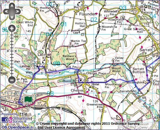
1 1 Chess & Gade Chalfont & Latimer Station - Latimer - Chenies - Sarratt - Kings Langley Station Length: 8 ¾ miles (14.25km) Underfoot: Well-trodden paths, mainly firm in all weather conditions, though some woodland and riverside sections could be muddy after heavy rain. Terrain: Frequent ascents and descents, but all are either very gentle, or short and steep. Maps: 1:50,000 Landranger 165 Aylesbury & Leighton Buzzard and Landranger 166 Luton & Hertford; 1:25,000 Explorer 181 Chiltern Hills North and Explorer 149 St.Albans & Hertford. Getting there: Chalfont & Latimer is on the London Underground Metropolitan Line, served by trains towards Amersham or Chesham. Trains run daily 4 times per hour from Baker Street (41 mins) via Harrow-on-the-Hill (22 mins). Alternatively, Chiltern Railways run faster trains 2 times per hour Monday-Saturday (1 train per hour Sundays) from London Marylebone (31 mins), also via Harrow-onthe-Hill (18 mins). Note that the Metropolitan line (and Chiltern services which share the route) are currently prone to disruption at weekends due to engineering works. Check before travel. Useful websites: Parts of this route follow the waymarked Chiltern Way and Hertfordshire Way. The route passes Chenies Manor House and crosses Chipperfield Common. Getting home: Kings Langley is served by 2 London Midland trains per hour Monday- Saturday (1 train per hour on Sundays) to London Euston (27 mins) via Harrow & Wealdstone (13 mins). Fares: The cheapest option based on a journey starting in central London is likely to be two single tickets - from other areas it may be cheaper to use a combination of Travelcards and single tickets. Whether you travel to Chalfont & Latimer by Underground or Chiltern Railway, Oyster Pay-As-You-Go will cost 3.50 off-peak (Under 10s travel free on Underground, 1 on Chiltern, via either route). A Kings Langley - Euston off-peak single costs 9.40 (child 3.50, railcard 6.20).
2 2
3 3 Arriving at Chalfont & Latimer station from the London direction, pass through the subway and exit through the ticket gates. Take the steps straight ahead (marked 'Private Footpath to Bedford Avenue'), cross the car park, and turn left on suburban Bedford Avenue. At the first junction, turn R and continue straight over the first crossroads along Chenies Avenue. Along here you pass an intriguing cross-section of Metroland architecture, from the 1920s villa to the copy-book 1990s semi. Chalfont & Latimer stations in fact serves three 'Chalfonts': Chalfont St Giles, Chalfont St Peter and Little Chalfont, where you are currently. There was basically nothing here prior to the twentieth century - the station (then called Chalfont Road) opened in 1889 amongst fields. This was archetypal Metroland: where the Metropolitan Railway's business plan depended heavily on selling the development land around their new stations. In this case it took some while: it was not until 1925 that the name Little Chalfont first appeared. At the next crossroads continue straight ahead, the road becoming a gravel track past large houses that abruptly ends, an unmarked path ahead plunging straight into the beech woods. Almost immediately, you come to a waymarked path junction, where you continue on the path straight ahead. The path drops through the woods, crosses a wider path and continues to descend towards Park Farm, glimpsed ahead through the trees. You emerge into the open valley floor of the Chess, Latimer House imposing over it on the hill ahead, pass through a kissing gate, across a field to reach the busy road along the valley. Cross straight over and take the path across a field, past a remarkable pastiche house next to Park Farm, to join a tarmaced track across the bridge - this crossesthe weed-choked river and then across the beautiful artificial channel that stretches down the valley, feeding mills and, to your left, producing an ornamental lake for Latimer House, dammed by the weir you see here. Latimer House, on the hill above, is on the site of an Elizabethan manor in which both Charles I was imprisoned en route to his trial in Westminster and his son took refuge before fleeing to France. The brick mansion now in its place dates from the 1860s and housed the Joint Service Defence College for much of the 20th century, now being a conference centre. Keep to the track, climbing gently above the river. You join a minor road, continuing slightly uphill, past the gates to Latimer House and then turn right atthe footpath sign. The path descends the field towards the clustered houses of Latimer village, to emerge on its stunning triangular village green, surrounded by 17th and 18th century houses. The obelisk in the centre of the green is a Boer War memorial, placed here due to one of the Barons of Chesham - the title of the Cavendish family of Latimer House - was a commander during this war. Intriguingly, his horse is buried under the stone mound next to the obelisk. At the bottom of the green, turn right on the road leading past the old schoolhouse and after about 50m turn left on the footpath marked as both the Chiltern Heritage Trail and the Chess Valley Walk. This leads onto a clear path along the meadows on the valley floor. Along this path you pass the altar-like Liberty Tomb, the grave of a William Liberty (a relative of the department store family), buried here in 1777, close to his now non-existent mansion.
4 4 At the path junction after the Tomb, continue straight ahead on the fenced path, which eventually passes the white-painted Mill Farm to emerge on a minor road. Turn right over the two waterways, past the atmospheric mill and veer right to the junction with the main valley road. Cross and take the lefthand of the two footpaths opposite, climbing quite steeply through the beech wood. The path leaves the wood between hedges and then runs between two ancient walls, with the ornamental chimneys of Chenies Manor at the end. You emerge by the gates of Chenies Manor, with the flint-knapped church on the left. Much of the current Chenies Manor dates from around 1460, built by Sir John Cheyne, whose family managed to have the whole village - which is clearly an estate village- named after them. It is particularly noted for its decorative cut brick chimneys, of which it has 22, and its remarkable gardens - which contain two mazes. The manor has, like much of the Chilterns, been used as a location for Midsomer Murders and also in the House of Cards trilogy. Opening hours are very limited: Wednesdays, Thursdays and Bank Holidays during the summer. Turn left down the manor's gravel drive to another superb village green in the centre of Chenies village. Take the road straight ahead cutting across the green and take the small road ahead between whitewashed number 28 and brick May Cottages. Follow this straight hilltop lane for around 1 mile, through the gates to Mountwood Farm. At the farm, veer right off the track to join the waymarked path beside it. After the farm buildings, you rejoin the track. After another gate, the track becomes fainter and twists down the hill between the beech woods. In the second field, your goal is the bottom right-hand corner where the path enters a narrow band of trees to arrive at a footpath junction. Take the path straight ahead (signed 'Sarratt church'). This leads across the valley floor for one final time, to cross the Chess on a long footbridge close to an attractive row of cottages. Just after the bridge, turn right (signed 'Chorleywood') on a faint path on a low bank just above the old course of the river (which here forms the boundary between Buckinghamshire and Hertfordshire). Through a kissing gate, you emerge on a track in front of a pair of cottages. Almost immediately turn left on a track which gives onto a grassy path leading uphill towards to large cream house of Godringtons. At the top of the hill, follow waymarks across the drive to arrive in front of compact Sarratt church, in the hamlet of Church End, a good mile from the village it serves. Historically, this hamlet was Sarratt, with the 12th century church at its heart. In keeping with the star-studded theme of this walk, the church was used as a location in Four Weddings and a Funeral. Take the gravel path in front of the church (signed 'Chess Valley') and on leaving the churchyard take the right-hand of the two paths, cutting diagonally across the high pasture. At the corner of the wood cross the small tarmac drive (next to delightful sculpted gates in the form of owls), continuing on the path towards Sarratt Green. A clear path through woods and across fields brings you out on the long linear green in the heat of Sarratt.
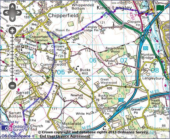
5 5 The village here, built around the 500m long village green which you are at the south-east end of, developed under the name of Sarratt Green before it became the dominant part of the village, and the original Sarratt became Church End. John le Carré chose the village as the site of the intelligence services' training school in his fictional world (and there are plenty of the sort of large country houses in the environs of the village which could fill that role). There is a village store to your left and the pleasant Cricketers pub to your right next to the willow shaded pond. Turn right along the road, keeping left past the bus stop and then turn left at the crossroads towards the King George V Sports Field. At the junction with The Briars, take the narrow path straight ahead (signed 'Commonwood'). Past the tennis courts, keep straight ahead at a path junction, descending closely into a dry valley to reach a minor road. Turn left, then immediately right towards Commonwood. The road climbs gently through the woodland to a road junction in front of a vast mock-tudor mansion. Turn right on the road through the scattered cottages and houses of Commonwood. At the junction in front of the Cart & Horses pub, continue straight ahead towards Penmanship Green. After 200m, the road turns sharp left and you continue straight ahead through a kissing gate onto a fenced path signed to Chipperfield Common. The path leads to the edge of a wood and at the junction here continue straight ahead (signed as the Easy Access Route) past the attractive pond. The path continues through the wood passing two fenced tumuli. Chipperfield Common is one of the largest commons in Hertfordshire, documented as a common since the Norman conquest. The tumuli (burial mounds) have been dated from the early Bronze Age (2300BC BC). Around 100m after the second tumulus, just before a signed route to the left, turn sharp right on a fainter path through the woods. Waymarks lead you out onto the road opposite a large manor house. Follow the road right for around 200m and at the bottom of the dip, turn left on path alongside the drive to Top Common. This delightful fieldside path drops eventually into an isolated dry valley, only toclimb straight out again. At the top of the hill, you reach the corner of a hedged path. Keep straight ahead along this, past another path junction and out into open fields again. After 2 fields you find yourself beside the A14 dual carriageway in its cutting. Climb to the footbridge, cross and on the opposite side turn right. After a kissing gate, the path turns left to drop through a field of maize to a track at the bottom. Here turn right to reach Broadfield Farm, where you pass through the farmyard to join the A4251 on the edge of Kings Langley. Cross the main road and turn right. Just before a roundabout take a left on Station Footpath, which you follow downhill to emerge on a road next to the Grand Union Canal. Cross the road to follow the footpath sign on the other side towards the station. This takes you across the canal on a lower bridge beside the road bridge. From the other side, a narrow tarmac path leads uphill past industrial units to come out on the road almost opposite Kings Langley station.
Mapledurham, Gallowstree and Shepherd s Green
 Mapledurham, Gallowstree and Shepherd s Green Pangbourne station Mapledurham Gallowstree Common Satwell Shepherd s Green Grey s Court Henley-on-Thames Length: 15 ½ miles (24.8km) Underfoot: Minor roads
Chevening and the North Downs
 1 Chevening and the North Downs Dunton Green station - Chipstead - Chevening - Knockholt - Hawley's Corner - Botley Hill - Oxted station Length: 12 ¼ miles (19.7 km) Underfoot: Portions of the walk are
Bewl Water & the High Weald
 1 Bewl Water & the High Weald Stonegate station - Stonegate - Wallcrouch - Newbarn - Cousley Wood - Wood's Green - Wadhurst station Length: 9 ½ miles (15.3km) Underfoot: Large portions of this path are
Ivinghoe Beacon and the Grand Union
 1 Ivinghoe Beacon and the Grand Union Cheddington station - Horton Wharf - Ivinghoe - Ivinghoe Beacon - Bridgewater Monument - Aldbury - Tring station Length: 11 ¼ miles (18.3km) Underfoot: The first mile
Gomshall station - Abinger Hammer - Abinger Common - Friday Street - Leith Hill - Coldharbour - Holmwood station
 1 To Leith Hill Gomshall station - Abinger Hammer - Abinger Common - Friday Street - Leith Hill - Coldharbour - Holmwood station Important note: this walk cannot currently be done on a Sunday due to the
Gomshall station - Abinger Hammer - Abinger Common - Friday Street - Leith Hill - Coldharbour - Holmwood station
 1 To Leith Hill Gomshall station - Abinger Hammer - Abinger Common - Friday Street - Leith Hill - Coldharbour - Holmwood station Important note: this walk cannot currently be done wholly by train on a
Medway Valley Orchards
 1 Medway Valley Orchards East Farleigh station - Kettle Corner - Farleigh Green - Buston Manor - Yalding - Yalding station Length: 6 ¾ miles (10.9km) Underfoot: Generally, this is a walk on good paths,
BISHOPSTONE CIRCULAR WALK
 BISHOPSTONE CIRCULAR WALK 4½ miles (7¼ km) - allow 2 hours (see maps on final pages) Introduction This walk is within the North Wessex Downs Area of Outstanding Natural Beauty and starts from the small,
Hadleigh Castle and Chalkwell Oaze
 1 Hadleigh Castle and Chalkwell Oaze Benfleet station Hadleigh Park Hadleigh Castle Leigh-on-Sea Chalkwell station A short stroll through the lush woods of Hadleigh Park high above the Thames-side marshes,
Walk 1. Cotswold Water Park. Gateway Centre to Cerney Wick, railway track to Lake 6, Gateway Centre.
 Cotswold Water ark Walk way A Swindon/ Cirencester Thomas and Severn Canal way to Cerney Wick, railway track to Lake, way. Spine Road East Hotel Time: hours (short walk km) Distance: km A level walk along
The Mendip Way. Route Directions and Maps Uphill to Wells
 The Mendip Way Route Directions and Maps Uphill to Wells Website: www.mendiphillsaonb.org.uk Email: mendip@mendiphillsaonb.org.uk Facebook & Twitter: @MendipHillsAONB Phone: 01761462338 1 Uphill to Loxton
BURGHCLERE PARISH RIGHTS OF WAY
 BURGHCLERE PARISH RIGHTS OF WAY Full descriptions compiled by Neill & Miggie Bruce All photos Miggie Bruce FP23 on Ridgemoor, looking south, with FP22 crossing by the bush FP1. From C183 Aldern Bridge
Ystwyth and Rheidol Bridleway Routes. Route 2:Llanilar Circular
 Ystwyth and Rheidol Bridleway Routes Route 2:Llanilar Circular Route overview and terrain: A long circle using connecting ridges with fine views to link the Rheidol and Ystwyth river valleys. The route
Hay Wood, Rowington and Baddesley Clinton - Warwickshire
 Hay Wood, Rowington and Baddesley Clinton - Warwickshire Starts at Lay-by alongside Hay Wood 2 hours 30 minutes 5.5miles 8.8km Leisurely ID: 0.683 Developed by: John Clift Checked by: Andy Page www.ramblersroutes.org
Slad over to Pitchcombe and back
 The walk climbs up from Slad over Wickridge Hill, descends to near Pitchcombe, then climbs back over Wickridge hill and round the back of Slad. Page 1 Start Point: SO 8718 0732 The Woolpack, Slad Length:
Pontfadog. Walk A. Walk A
 Walk A A Bird s eye view of the village 2km. (1 1 /2 miles); height gain 45m. (150ft) about 45 minutes. Six minutes walk along the main road towards Glyn Ceiriog reach a signpost to Llwynmawr. Take the
Woodland Walk If you enjoyed this walk there are two others available in the same area.
 The Woodland Walk 11-12 kilometres (7-8 miles) 4-5 hours Terrain: some easy hills Can be slippery when wet 5 stiles Unsuitable for a pushchair/wheelchair Uses OS map 197 Parking: Pulborough Station and
Cuxton, Ranscombe and Cobham
 1 Cuxton, Ranscombe and Cobham Cuxton station - Ranscombe - Cobham Park - Cobham - Sole Street station Length: 5 ¾ miles (9.4 km) Underfoot: Most of this walk is on well-made paths or tracks, with a few
Leaden Boot Challenge ROUTE INSTRUCTIONS
 Leaden Boot Challenge ROUTE INSTRUCTIONS Section 1 Alstonefield to Ilam From the village hall car park turn R then L and pass through the village keeping to the R to enter Church Street. Pass the Church
START - UPHILL BEACH. (tidal!) The West Mendip Way is route-marked with these round blue signs
 The West Mendip Way is route-marked with these round blue signs") START - UPHILL BEACH Start Times: 10:30 11:15 12:00 Please allow sufficient time to check in with the marshals Start on the beach at the high water line (tidal!) The West Mendip Way is route-marked with
START - UPHILL BEACH Start Times: 10:30 11:15 12:00 Please allow sufficient time to check in with the marshals Start on the beach at the high water line (tidal!) The West Mendip Way is route-marked with
Bentley station - Alice Holt Forest - Frensham Great Pond - Rushmoor - Pitch Place - Gibbet Hill - Haslemere station
 1 Devil s Punch Bowl and Surrey Heaths Bentley station - Alice Holt Forest - Frensham Great Pond - Rushmoor - Pitch Place - Gibbet Hill - Haslemere station Length: 13 ¾ miles (22.0 km) Underfoot: Almost
Aston Rowant Discovery Trail
 The walk was developed by Aston Rowant Parish Council. The Trail is stile-free and fully way-marked. The circular route is 5.3m but with the extension to a pub and hotel 6.2m. Key Main Aston Rowant Discovery
Leaden Boot Challenge 2016 ROUTE INSTRUCTIONS
 Leaden Boot Challenge 2016 ROUTE INSTRUCTIONS Section 1 Alstonefield to Ilam (CP2) From the village hall car park turn R then L and pass through the village keeping to the R to enter Church Street. Pass
Sponsored by. statestreet.com
 /STATESTREETISLANDWALK #ISLANDWALKJSY Sponsored by statestreet.com Important Information If you forget everything else PLEASE remember the following.» Remember to check OUT of every checkpoint» If you
Ardingly Lake, Ouse Valley, Borde Hill
 point your feet on a new path Ardingly Lake, Ouse Valley, Borde Hill Distance: 14 km=9 miles or 12½ km=8 miles Region: West Sussex Author: Hautboy Refreshments: Borde Hill Map: Explorer 135 (Ashdown Forest)
3.1 Bowness-on-Solway to Carlisle
 3.1 Bowness-on-Solway to Carlisle Map panel 1 Distance 15 miles (24 km) Terrain minor roads, tracks, field paths and riverside footpath, muddy in places Grade easy, with gentle gradients on undulating
A Circular Walk from Chapel Carn Brea
 A Circular Walk from Chapel Carn Brea 4.3 Miles A Walk Visiting Five Historic Ancient Sites This circular walk offers the possibility of several alternatives, depending on the walker s available time and
Hindhead, Keffolds Copse and Gibbet Hill
 point your feet on a new path, Keffolds Copse and Gibbet Hill Distance: 6 km=4 miles Region: Surrey Author: Schwebefuss Refreshments: Punch Bowl Café moderate walking Date written: 14-apr-2015 Last update:
Basingstoke Canal and Dogmersfield
 point your feet on a new path? Basingstoke Canal and Dogmersfield Distance: 11 km=7 miles easy ing or 2 s of 7½ km=4¾ miles and 5¼ km=3¼ miles Region: Hampshire Author: Botafuego Refreshments: The Barley
Beautiful Walks from the Blue Ball Inn
 Walk No. 5 RIVER VALLEYS AND MOOR Countisbury, Watersmeet, Hillsford Bridge, Cheriton, Shilstone Hill, Rockford and Chiselcombe. 8.5 MILES APPROX. Walking time four and a half hours approx. OS 1;25,000
The. History Walk. WWII Armaments factory
 The History Walk WWII Armaments factory 4.8-6.5 kilometres (3-4 miles) 2.5-3.5 hours Terrain: easy Can be slippery when wet No stiles Unsuitable for a pushchair/wheelchair Uses OS map 197 Parking: Pulborough
ID: 283 Distance: 6.2 miles Height gain: 500 Metres Map: Explore OL 19 Contributor David and Chris Stewart
 Walkingworld Wild Boar Fell ID: 283 Distance: 6.2 miles Height gain: 500 Metres Map: Explore OL 19 Contributor David and Chris Stewart Features Birds, Great Views, Hills or Fells Description: Wild Boar
Approximate distance: 4.5 miles For this walk we ve included OS grid references should you wish to use them. Start. End
 Approximate distance: 4.5 miles For this walk we ve included OS grid references should you wish to use them. 2 1 Start End 4 3 N W E S Reproduced by permission of Ordnance Survey on behalf of HMSO. Crown
The 34 th Poppyline Marathon
 The 34 th Poppyline Marathon Saturday 9th June 2018 - Route Description Emergency number: 07906 404673 or 07597 052572 Ahd - Ahead BL - bear left BR - bear right BW - bridleway Cont - continue FB - footbridge
HARDMOORS ROUTE DESCRIPTION
 HARDMOORS 60 2016 ROUTE DESCRIPTION RACE START (GUISBOROUGH) - CHECKPOINT 2 (SALTBURN) DISTANCE 9 MILES CUT OFF TIME 1030 GRID REF OS 666 208 1. Leaving the Sea Cadets Hall, turn left onto the road and
CWMGIEDD FROM ABERCRAVE
 Abercrave to Cwmgiedd Walk Page 1 Starting from The Abercrave Inn. Grid Ref: SN 824128 From the Abercrave Inn, an 11.3km (7 miles) walk to the foothills of the Cribarth Mountain, then through forest to
Map: Landranger #27 Forres and Nairn and 36 Grantown and Aviemore
 THE DAVA WAY This is a newly created long distance route that runs from Forres to Grantown, mostly following the old railway line. You will need to detour around a couple of sections that are not really
Description for the Round Rotherham 8 December 2007
 Directions: L left R right ½L, ½R half left, half right X cross X Rds cross roads SA straight Codes: BR bridge FP footpath FB footbridge RWY railway CP car park RD road Description for the Leave Event
The Hundred Parishes
 The Hundred Parishes Walks from railway stations number 3 3 miles (5kms) circular walk from Stansted Mountfitchet Start & finish: Stansted Mountfitchet station. Ordnance Survey Explorer Map 195. Grid Reference:
The Sudbury Branch Walks 1-4
 The Sudbury Branch Walks 1-4 Sudbury Branch Walks From Sudbury to Marks Tey The gentle declivities, the luxuriant meadow flats sprinkled with flocks and herds... the sound of water escaping from the mill
GRINDLEFORD GALLOP 2018
 GRINDLEFORD GALLOP 2018 Route Information The Grindleford Gallop follows a fixed 21 mile route through the lanes and paths of Derbyshire. All competitors must follow this route. An OS map of the area with
Mersey Valley Timberland Trail
 Route Pack Page 1 Route Summary A long distance linear walk on roads and country paths linking town and countryside to parks, woodlands and other open spaces. Grade Distance Accessibility Allow Start Map
Freefolk and Whitchurch
 Trail Activity Type Terrain Author Distance Ascent Location : HAMPTR0026 : Walk : Tea Shop : Towpaths and Cycle Tracks : Jean Patefield : 5.6 miles / 9 kms : 377 feet / 115 metres : SU487488 / RG28 7NN
Friday Street, Leith Hill, Holmbury Hill
 point your feet on a new path Friday Street, Leith Hill, Hill Distance: 12 km=7 miles easy-to-moderate walking + optional tour of Hill: 1½ km=1 mile Date written: 27-oct-2011 Region: Surrey Author: Schwebefuss
Beamers Trail. Walk No.1. 6 miles. (easy with some moderate ascents and descents)
") Beamers Trail Walk No.1 6 miles (easy with some moderate ascents and descents) 1 BEAMERS TRAIL 6 miles (easy with som WALK The Warpers Trail forms part of the long distance Witton Weavers Way. This is
Beamers Trail Walk No.1 6 miles (easy with some moderate ascents and descents) 1 BEAMERS TRAIL 6 miles (easy with som WALK The Warpers Trail forms part of the long distance Witton Weavers Way. This is
Ranmore Common and Polesden Lacey
 point your feet on a new path Ranmore Common and Polesden Lacey Distance: 9½ km=6 miles Region: Surrey Author: Fusszweig Refreshments: Polesden Lacey easy walking Date written: 20-dec-2016 Last update:
Singleton and the South Downs
 point your feet on a new path Singleton and the South Downs Distance: 13½ km=8½ miles easy walking with a few steeper sections Region: West Sussex Author: Hautboy Refreshments: Singleton, Hill Barn Date
Aeron & Arth walks 4 walks for all the family to enjoy
 Aeron & Arth walks walks for all the family to enjoy Please take note that the maps illustrating these walks are intended as a rough guide only. You should use the most recent version of the relevant Ordnance
Lewes and the South Downs
 point your feet on a new path and the South Downs Distance: 0 km=1½ miles moderate walking with long easy stretches Region: East Sussex Author: Hautboy Refreshments: Date written: 8-apr-013 Map: Explorer
Bentley and Isington Mill Lower Froyle: The Anchor
 point your feet on a new path and Isington Mill Lower Froyle: The Anchor Distance: 12 km=7 miles Region: Hampshire Author: Botafuego Refreshments: Lower Froyle, easy walking Date written: 6-may-2012 Date
Torrance. Mapped Heritage. The following maps demonstrate the spatial strategy for the Torrance trails. Trail themes
 Torrance The following maps demonstrate the spatial strategy for the Torrance trails. The heritage and proposed trails are presented on two maps per area: Map 2A - Existing heritage locations Map 2B -
Baggy Point, Croyde, North Devon
 Baggy Point, Croyde, North Devon A walk using the South West Coast Path that is likely to be suitable for people with impaired mobility or with a pushchair, wheelchair, or mobility scooter. The Coast Path
Penn Common and Bramshaw Wood
 Trail Activity Type Terrain Author Distance Ascent Location : HAMPTR0025 : Walk : Pub : Towpaths and Cycle Tracks : Anne-Marie Edwards : 5.3 miles / 8.5 kms : 381 feet / 116 metres : SU253173 / SP5 2BZ
Walk 1: Highfield, Lob Wood and The River Wharfe
 Walk 1: Highfield, Lob Wood and The River Wharfe Start: The Hen Pen Garden, Main Street, Addingham LS29 0NS, SE 077 498. Alternative Start: Near Bolton Bridge SE 071 525 (see page 6). Full walk: 4.5 miles
Berkhamsted and Hemel Hempstead from Iver Marina
 UK Canal Boating UK Canal Boating Escape with a canal boating holiday! Telephone : 01395 443545 Email : contact@ukcanalboating.com Booking Office : PO Box 57, Budleigh Salterton. Devon. EX9 7ZN. England.
Pangbourne, Mapledurham and The Thames
 Trail Activity Area Type(s) Author Distance Ascent Location : BRKSTR0003 : Walk : The River and Reading : Country Escape : D Scott : 5.7 miles / 9.1 kms : 66 feet / 20 metres : SU634765 / RG8 7AN Whitchurch
HARDMOORS 55 RACE ROUTE 2018 HELMSLEY - GUISBOROUGH
 HARDMOORS 55 RACE ROUTE 2018 HELMSLEY - GUISBOROUGH HELMSLEY - CHECKPOINT 1 (WHITE HORSE) 1. Leave RACE START, continue ahead on road (Baxtons Sprunt) At crossroads turn right down Canons Garth eventualy
White Horse Trail Route directions (Clockwise) split into 10 section with an alternative for the Alton Barnes to Cherhill section
 split into 10 section with an alternative for the Alton Barnes to Cherhill section") White Horse Trail Route directions (Clockwise) split into 10 section with an alternative for the Alton Barnes to Cherhill section S1 White Horse Trail directions Westbury to Bulkington Maps: OS Explorer
White Horse Trail Route directions (Clockwise) split into 10 section with an alternative for the Alton Barnes to Cherhill section S1 White Horse Trail directions Westbury to Bulkington Maps: OS Explorer
Kingley Vale and the Downland Churches
 point your feet on a new path Kingley Vale and the Downland Churches Distance: 21 km=13 miles or 10½ km=6½ miles Region: West Sussex Author: Hautboy Refreshments: Stoughton, Walderton moderate walking
Self-Guided Walk Langdale Pikes. Start & Finish: NT car park (free to members) at Sticklebarn - on the right just beyond the New Dungeon Ghyll hotel.
 at Sticklebarn - on the right just beyond the New Dungeon Ghyll hotel.") Self-Guided Walk Langdale Pikes Key Information These mountains form a collection of spires and cliffs on the north side of Langdale. This walk visits four of the main tops Pavey Ark, Harrison Stickle,
Self-Guided Walk Langdale Pikes Key Information These mountains form a collection of spires and cliffs on the north side of Langdale. This walk visits four of the main tops Pavey Ark, Harrison Stickle,
River Isla B951. Diarmid s Tomb
 3. 4 Spittal of Glenshee to Kirkton of Glenisla Distance 14.6 miles 23.5 km Terrain mainly on rough moorland path with boggy bits and stream crossings, then heading east along at the B951 for 2.5 miles,
The Castor Roman Walk
 The Castor Roman Walk Welcome to the Route Plan and teachers notes for the Castor Roman Walk. The walk is approximately 3km, with an optional extension of 0.7km. We suggest that you bring with you OS Explorer
Reigate Hill and Gatton Park
 point your feet on a new path Reigate Hill and Gatton Park Distance: 11½ km=7 miles easy-to-moderate walking or 2 walks of 6½ km=4 miles and 5½ km=3½ miles Region: Surrey Author: Schwebefuss Refreshments:
Eastbourne. Alfriston 3¾ 6 3¾ 6. Birling Gap. Exceat
 3.8a Alfriston to Eastbourne (footpath) Map panel 6 (page 64) Distance 10½ miles (17 km) Terrain valley walk initially, first along riverbank path then hillside paths above, including stretch through forest;
Merritts Traverse. 1928m
 Merritts Traverse 3 hrs Hard track 5.8 km Circuit 4 167m This walk starts with a scenic journey to the top of the hill on the chairlift. Starting along Merritts Nature walk, this walk soon detours down
Beautiful Walks from the Blue Ball Inn
 Walk No. 2 WINSTONS WALK Countisbury, Wind Hill, Watersmeet, Ash Bridge and Winston s path. 5 Miles approx. Walking time- Two and a half hours approx. (Not including Breaks) OS 1:25,000 Sheet 64/74 Lynton
The Great Malvern Town Centre Walk. The Great Malvern Alternative Town Centre Walk
 The Great Malvern Alternative Town Centre Walk This is an abridged version of walk 4, from the Pictorial Guide to the Malvern Hills Book Two: Great Malvern Available from the Tourist Information Centre,
A leisurely one mile stroll through the history of Aldershot s Manor park, considered by many as the most attractive and pleasant parts of our town.
 Figure 1 Entrance to Park from the Aldershot Green/Churchill road end A leisurely one mile stroll through the history of Aldershot s Manor park, considered by many as the most attractive and pleasant parts
Whipsnade and Dunstable Downs Studham, Kensworth, Tree Cathedral
 point your feet on a new path Whipsnade and Dunstable Downs Studham, Kensworth, Tree Cathedral Distance: 15 km=9½ miles or 7 km=4½ miles Region: Chilterns, Bedfordshire Author: Phegophilos Refreshments:
Tour Of Tameside The alternative tameside trail
 Tour Of Tameside The alternative tameside trail A 30 mile walk around the borough of Tameside taking in the Valleys of the Medlock, Etherow and Tame. The whole walk can be completed in one day by anyone
WALKS AROUND WOODHURST
 WALKS AROUND WOODHURST With Walks To Woodhurst from North St. Ives Woodhurst is situated on the verge of an elevated tract of table land four miles north of St. Ives. Its footpaths vary from leafy lanes
Mt Kuring-gai Track to Berowra station
 Mt Kuring-gai Track to Berowra station 4 hrs 15 mins 9.7 km One way Hard track 4 553m This walk explores three valleys, with great displays of wild flowers in spring, and some nice sandstone overhangs.
London to Oxford Trek map
 London to Oxford Trek map Route stats: 103.6 km (64.4 miles) with 800 metres of climbing Start time: 08:00-09:00am Checkpoints: Start - Spelthorne Leisure Centre TW18 1AJ Distance: 0km (0m) Leave here
Morning Copse near Maidstone, Kent acres of Ancient Woodland with a pond, bluebells and mature oak. 26,500 (freehold)
") WOODS 4 SALE Phone: 01248 364 362 www.woods4sale.co.uk UK Woodland & Woods For Sale: Specialising in the Sales of Small Woodlands in England, Scotland and Wales for Recreation, Wildlife Conservation and
WOODS 4 SALE Phone: 01248 364 362 www.woods4sale.co.uk UK Woodland & Woods For Sale: Specialising in the Sales of Small Woodlands in England, Scotland and Wales for Recreation, Wildlife Conservation and
Steep and Shoulder of Mutton Hill
 Trail Summary Trail Activity Type Author Distance Ascent Location : HAMPTR0073 : Walk : Pub : Nick Channer : 5.7 miles / 9.1 kms : 794 feet / 242 metres : SU745253 / GU32 2DD With its spectacular beech
Centurion Way Chichester
 Centurion Way Chichester Work book of plans to show details of the Centurion Way, its links, and potential developments and enhancements from linking to the South Downs National Park all the way to the
Bradfield, Bucklebury, Stanford Dingley A Drink with the Middletons
 point your feet on a new path, Bucklebury, Stanford Dingley A Drink with the Middletons Distance: km=3 miles or 0 km= miles or 8 km= miles easy-to-moderate walking Region: Berkshire Author: MacMeadow Refreshments:
As pretty as a picture
 43 As pretty as a picture Discover this enchanting stroll through classic Kentish countryside and peaceful Plaxtol. Shipbourne Village Green 44 44 Shipbourne Crown copyright 0009238. St Giles Church Location:
Fetcham Downs and Bocketts Farm A magical teashop walk
 point your feet on a new path Fetcham Downs and Bocketts Farm A magical teashop walk Distance: 3 km=2 miles or 4 km=2½ miles Region: Surrey Author: Fusszweig Refreshments: Bocketts Farm easy walking Date
Difficult Run Stream Valley Park
 Difficult Run Stream Valley Park The more intense mountain bikers have known about for Difficult Run for some time. Equestrians have known it longer. Eight miles of unpaved trail, the Rails to River Trail
1. Waterfall Gully Mt Lofty. 5 Of the Best Hikes in Adelaide
 Adelaide is a beautiful city, and one of the most incredible things about Adelaide is the quality of bushwalking available on the suburban fringe. It is surrounded by the Mt Lofty Ranges, and much of the
Approximate distance: 7.5 miles For this walk we ve included OS grid references should you wish to use them.
 Approximate distance: 7.5 miles For this walk we ve included OS grid references should you wish to use them. 6 5 7 8 4 1 2 Start End N 3 W E S Reproduced by permission of Ordnance Survey on behalf of HMSO.
Beachy Head and Eastbourne
 point your feet on a new path Beachy Head and Eastbourne Distance: 2 km=4½ miles Region: East Sussex Author: Stivaletti moderate walking Date written: 25-jun-200 & 6-jun-205 Last update: 28-feb-208 Refreshments:
COSTA BLANCA MOUNTAIN WALKERS - WALK DESCRIPTION. Visit for more walks descriptions in Spain
 Visit www.walksinspain.org for more walks descriptions in Spain Walk description originally prepared by:- Ralph Phipps Last Updated 15 th July 2016 Title of Walk Location of Start (include name of nearest
s point your feet on a new path
 s point your feet on a new path Arundel: Park, Hills and Forests Distance: 20 km=12½ miles Region: West Sussex Author: Hautboy Refreshments: Arundel, Houghton, Whiteways Lodge moderate walking Date written:
Jerusalem Bay Track (Cowan to Brooklyn)
") Jerusalem Bay Track (Cowan to Brooklyn) 5 hrs 30 mins 13.4 km One way Hard track 4 654m This Cowan to Brooklyn Station walk is a popular section of the Great North Walk, with scenery ranging from foreshore
Jerusalem Bay Track (Cowan to Brooklyn) 5 hrs 30 mins 13.4 km One way Hard track 4 654m This Cowan to Brooklyn Station walk is a popular section of the Great North Walk, with scenery ranging from foreshore
The Bridestone Rocks from Lydgate
 Print this page Back to results The Bridestone Rocks from Lydgate Ancient tracks and gritstone outcrops, with terrific views of the steepsided Cliviger Valley. Distance 5 miles (8km) Minimum time 2hrs
Chandlers Cottage I Fir Tree Hill I Chandlers Cross I Rickmansworth. aitchisons.co.uk TOWN & COUNTRY
 Chandlers Cottage I Fir Tree Hill I Chandlers Cross I Rickmansworth aitchisons.co.uk TOWN & COUNTRY Fir Tree Hill I Chandlers Cross I Rickmansworth I Hertfordshire I WD3 4LZ An immaculately presented three
walking
 Two Castles Trail Meander through rolling countryside full of history on this 24 mile waymarked walking route between Okehampton and Launceston Castles www.devon.gov.uk/ walking www. dartmoor.co.uk www.
A Tour of the Valle del Gizio
 Walk 25 A Tour of the Valle del Gizio Walking time 5hrs 30mins (4hrs if Colle Mitra is omitted) Difficulty 2 (likely to be snowbound in winter months); 1 (if Colle Mitra is omitted) Ascent/descent 570m/570m
West Hoathly, Balcombe & Bluebell Railway Steam and Seed Bank
 point your feet on a new path West Hoathly, Balcombe & Bluebell Railway Steam and Seed Bank Distance: 8 km= miles or walks of 9½ km=6 miles and 0 km=6½ miles Region: West Sussex Author: Stivaletti Refreshments:
COSTA BLANCA MOUNTAIN WALKERS - WALK DESCRIPTION. Visit for more walks descriptions in Spain
 COSTA BLANCA MOUNTAIN WALKERS - WALK DESCRIPTION Visit www.walksinspain.org for more walks descriptions in Spain Walk description originally prepared by:- Ralph Phipps Last Updated 25th Sep 2015 Title
The Copper Horse Lodge, Windsor Park George III statue and view of Windsor Castle Andy Oakes Julian P Guffogg Don Cload
 Trail Activity Area Type(s) Author Distance Ascent Location : BRKSTR0008 : Walk : Windsor and the South East : Country Escape : Andy Oakes : 5 miles / 8.1 km : 239 feet / 73 metres : SU947727 / SL4 2BT
This path goes past an old tree nursery and sawmill. After 800m it crosses over a lane. Follow the bridleway fingerpost into the woods.
 FRENSHAM PONDS 11K CIRCULAR TRAIL 2½ HRS GU10 2DA This magnificent heathland trail starts in woodland and then brings you out onto the open heather of Frensham Common, with no roadwork! The route runs
Firle, Alciston and the South Downs
 point your feet on a new path Firle, Alciston and the South Downs Distance: 16 km=10 miles Region: East Sussex Author: Hautboy Refreshments: Alciston, Firle moderate walking with long easy stretches Map:
river point your feet on a new path
 river point your feet on a new path Frensham and Bourne Wood Distance: 13 km=8 miles or 11 km=7 miles easy walking with a few steep gradients Region: Surrey Author: Schwebefuss Refreshments: Shortfield
Telluride-to-Moab Alternative Singletrack Options
 Telluride-to-Moab Alternative Singletrack Options Day 1 Day 1 Alternate 1: Galloping Goose to Deep Creek. 18.4 miles, ascent 3,530ft, descent 1,388ft. This is fun, flowey, moderate to intermediate singletrack
Lordenshaw. What are cup & ring marks?
 Lordenshaw Lordenshaw hill has one of the largest clusters of ancient cup and ring marked stones in the UK. We ve chosen four interesting spots we d like to share with you. What are cup & ring marks? The
Staples Lookout to Mt Wondabyne loop
 Staples Lookout to Mt Wondabyne loop 4 hrs 3 mins 1.8 km Circuit Hard track 337m This walk starts and finishes at Staples Lookout, on Woy Woy Rd. The walk follows sections of the Great North Walk around
Wilstone, Hertfordshire OFFERS IN EXCESS OF 800,000
 Wilstone, Hertfordshire OFFERS IN EXCESS OF 800,000 TRING Wilstone OFFERS IN EXCESS OF 800,000 ***PURCHASE WITH STERLING & GET 500 CASHBACK ON COMPLETION*** Situated in the sought after Hertfordshire village