Mapledurham, Gallowstree and Shepherd s Green
|
|
|
- Mervin Powell
- 5 years ago
- Views:
Transcription
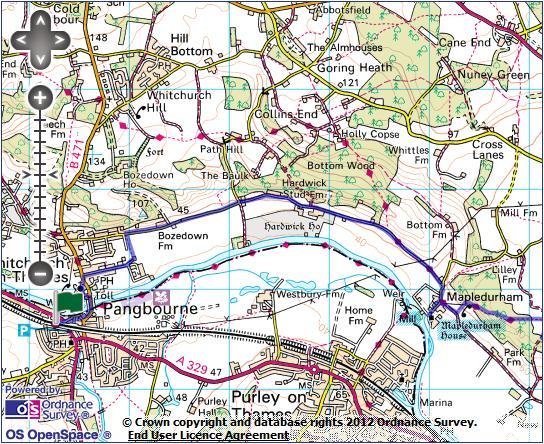
1 Mapledurham, Gallowstree and Shepherd s Green Pangbourne station Mapledurham Gallowstree Common Satwell Shepherd s Green Grey s Court Henley-on-Thames Length: 15 ½ miles (24.8km) Underfoot: Minor roads and firm paths along the Thames valley, then generally firm paths, but with muddy sections on paths and bridleways through some of the beech woods. Terrain: Generally gently undulating, but with a couple of sharp climbs out of and into the Thames valley. Maps: 1:50,000 Landranger 175 Reading & Windsor; 1:25,000 Explorer 171 Chiltern Hills West. Getting there: Two trains an hour (one on Sundays) runs from London Paddington to Pangbourne (64 mins) via Ealing Broadwayfor Central and District lines (57 mins). From London Paddington, it is often faster to take one of the frequent non-stop services (heading for the West of England or South Wales) to Reading, and to change there for a service to Pangbourne. Online journey planners will show you when this is the case. Useful websites: Parts of the route follow the Chiltern Way Extension. You pass the house and mill at Mapledurham and the Tudor mansion at Grey s Court. Getting home: Henley-on-Thames is situated on a branch line, meaning that a change is required to return to London. Trains run hourly every day from Henley to Twyford (12 mins), from where there are two trains per hour (one on Sundays) to London Paddington (51 mins) via Ealing Broadway (40 mins) for District and Central lines. Fares: You will need to purchase two tickets to cover these journeys. A London to Pangbourne return for ( 8.50 child, railcard) will cover the outward journey, and most of the return. You will also need a Henley to Twyford single for 3.20 ( 1.60 child, 2.10 railcard).
2
3
4 Route description Arriving at Pangbourne from the east, turn left through station subway to exit via the Londonbound platform. Turn right down the station approach, crossing busy Shooters Hill at the bottom with care. Take The Wharf opposite, and keep to the footpath close to the Thames. At B471, turn left to cross the island-strewn Thames on the Whitchurch toll bridge (no charge for pedestrians). The current steel lattice toll bridge dates from 1902, and there has been a bridge on this site since 1792, approved by Act of Parliament the toll house, still displaying the historic list of charges, is the 18th century original. Before the bridge, Pangbourne and Whitchurch-on-Thames were linked by ferry. The bridge takes you from Berkshire into Oxfordshire. After the toll booth, turn left on the Thames Path along drive to mill. Just after ChurchCottages, take narrow path right (signed To Church ), cut across the graveyard and join the drive by Waliscott Lodge to return to main road. Whitchurch s parish church of St Mary has Norman roots, but was almost completely rebuilt in the gothic revival style in 1858, retaining little more than the Norman south door. Cross the road, turn left on the pavement and just before the Greyhound pub, turn right along Eastfield Lane. Follow this long, straight road past prosperous houses. At end of road, take the left hand fork towards primary school buildings and just before school gates turn left on broad path. This soon brings you out on a minor road along the valley floor, where you turn right. Follow road for a little under a mile - paddocks full of alpacas, looking remarkably at home in the Thames valley, have replaced the vineyard marked on the map. Where road swings sharp left, keep straight ahead through an ornate gateway and past lodge houses along the tree-lined drive through the Hardwick Estate, passing the timbered stud farm. This is the parkland of Hardwick House, a Tudor mansion, now in the hands of the Baronets Rose of Hardwick. The first Baronet Rose is thought to be a model for Mr Toad in The Wind in the Willows, and the house to be the basis for Toad Hall.
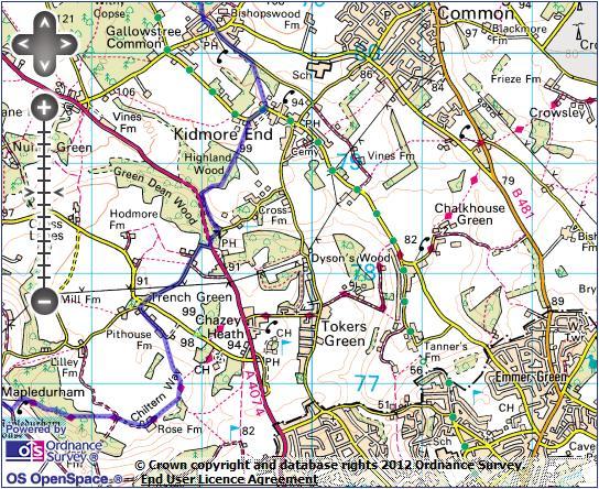
5 Coming to a junction of three parallel tracks divided by yew hedges, keep to the lefthand of the three. This track passes the mainly hidden Hardwick House, then runs along the hillside just above the flood plain, with the meandering Thames glinting below. Passing East Lodge and its gateway, the route becomes a clear path. On reaching a small road, turn right towards the rooftops of Mapledurham ahead. By the lodgehouse at the entrance to village, the route turns L, but keep SA to visit village. Mapledurham is a rather isolated Thameside hamlet, linked by just one dead-end road and with no river crossing. The name means maple tree enclosures, and existed as two manors at the time of the Doomsday Book. Today it is a quiet, picturesque village of almshouses and cottages clustered around Mapledurham House, one of the largest Elizabethan houses in Oxfordshire and its 14th century church. Across the road from the church is the last operational watermill on the Thames, still producing flour, using a new Archimedes screw set amongst the 15th century buildings. Perhaps Mapledurham s greatest claim to modern fame is as a location for the 1976 cult war film The Eagle Has Landed, where it stood in for an English coastal village, featuring house, church and mill heavily. Return to the lodge and turn right on a concrete track, signed as a bridleway to Gravel Hill. Where the track swings slightly right, turn left over a stile (waymarked), cross the field ahead to reach a second stile into wood. The clear path twists through the woodland, with a couple of short, steep climbs, toeventually exit into open, high fields. A narrower, but still clear, path keeps straight ahead to a track junction. Take the track straight ahead towards the buildings of Rose Farm. Keep to the concrete track between farm buildings and where this ends, keep to the left hand waymarked track above the wood. By the end of wood, turn left at a track junction, cross another track,then where the main track veers right onto golf course, keep straight ahead on a waymarked path which follows a row of trees across field. Pass through a field boundary and then follow a faint path across a large, often muddy field towards the white cottage of Pithouse Farm. Join the farm track and continue past Trench Green to a minor road. Turn right, and at crossroads keep straight ahead towards Tinkers Green.
6 Keep to the tiny road past the fine thatched cottage at Tinkers Green to reach the busy A4074 Oxford-Reading road. Cross with care, turn left along the verge and very soon turn R on Mill Lane, dropping steeply into a small valley. At the bottom of the hill, turn left on an unsigned path just inside wood. Before long, you are back alongside the A4074. At the corner of the wood, by a fence post with a Walkers Welcome sign, turn R on a faint path climbing through beechwoods, keeping close to edge of wood. Once at the top of the rise, the path runs amongst the holly bushes which dominate the woodland floor. There are occasional painted white arrows on trees to confirm you are on the right route. The bridleway emerges onto a fenced path beside paddocks which leads out onto road. Turn right, towards the houses at Kidmore End. Just after a sharp bend to the left, turn left at the entrance to Myrtle Cottage, and immediately veer left again on a signed narrow footpath between hedges. The path cuts straight across a field and wood to join the minor Hazlemoor Lane. Turn left, soon reaching the houses of Gallowstreet Common. At the cross-roads, keep straight ahead (the Reformation pub is just to the left) on a minor road. The defunct village well, with winding equipment still intact, is on the right just after the junction. Where the road veers sharply left, turn right on a footpath, which immediately divides. Take the middle of three paths, cutting through New Copse amongst tall beech trees. Keep straight ahead, following the white painted arrows. Eventually, these lead you out of the wood and along a rhododendron infested strip between fields. Just past bottom of a small dip, emerge into open field and head towards a white gabled house. Emerging on a minor road, head straight across on the driveway to Park Farm House. Pass straight ahead through a kissing gate and follow the hedgerow across sheep grazed fields. There are distant glimpses of the roofs of the vast Wyfold Court through hedges to the left. Wyfold Court is an immense French Gothic Revival mansion, built by a student of Westminster architect Charles Barry during the 1870s. It served a period as a hospital, before being restored as apartments and a country estate. A second kissing gate leads into a wood, with a clear path following the edge of the trees to arrive at a small group of houses.
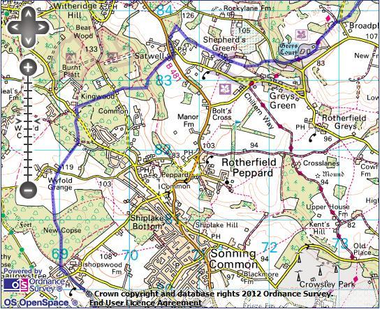
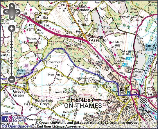
7 At a private tarmac road turn right, then immediately left (following a waymark) on a small path through the wood. Plentiful white arrows guide you through trees. On reaching a linear clearing along a telegraph line, turn left,then quickly right to join a road just before a junction and cottage. Take the right hand road at the junction, marked as a dead end. By the second house (Holly Tree Cottage) take a bridleway signed to the right. Keep straight ahead through the brackeny woods of Kingswood Common to a minor road by a small house called Colmore. Keep straight ahead, following a bridleway waymark along the edge of the wood. The path eventually drops steadily into small wooded valley (the right of way marked on the map doesn t exist on the ground keep to the route described here). At the bottom, turn left on a faint track. After about 50m, a second faint track forks right, climbing slightly. This swings right and ascends a little more steeply, eventually breaking out of the wood to some modern houses at Satwell. Cross the main road and take the minor road opposite to a junction by the 16th century Lamb pub. Turn left towards Highmoor and Nettlebed. Where this road rejoins the B481, turn right on a signed footpath into the woods. After about 200m, painted arrows on the tree mark a path junction. Turn right here, through a kissing gate into fields. The path keeps straight ahead across four fields, with good views north into the heart of the Chilterns. The path emerges in the eponymous open space in the centre of the picturesque hamlet of Shepherd s Green. Keep to the north side of the green, past an attractive house called The Strip, cross a small road and take the signed, fenced footpath ahead. On entering the small Sam s Wood, the path forks. Take the left hand path, cutting through the wood and then dropping steeply to Rocky Lane (ignore the permissive path signed to the right). Turn right and after 100m turn left on a footpath signed as the Chiltern Way Extension. The path very soon joins a tarmac drive which leads past the National Trust property at Greys Court. Greys Court is a Tudor mansion set in attractive gardens, including walled gardens, a maze and a 14th century fortified tower, the sole remains of a previous castle on this spot. At one point, the Court was owned by Mary Queen of Scots jailer.
8 After the Greys Court entrance booth, veer left to a waymarked gate into a picnic area. From here, a series of gates leads to a small pond. By this, keep straight ahead at a waymarked junction (leaving the Chiltern Way Extension). The path curves around farm buildings and joins a tarmac track. Turn right down thisfor 10m, then follow the footpath waymark left to cross a small road and continue into woods. The path is often unclear, but there are plenty of arrows on the trees. Eventually, you arrive at arrows marking a path junction turn right here, alongside a low earthwork. Ignore paths signed to left and right, to pass through a dip, eventually entering younger woodland by a farm. Exit the woodland onto a golf course. Waymarks lead you to a line of trees which youfollow across the course. Where you come to the edge of a grazing field on the left, keep to the track beside it, then cross a stile onto a private road ahead. Follow the road, passing through a gateway. Immediately after the very modern Croft Cottage, turn left on a footpath descending to a road on a housing estate on the edge of Henley-on-Thames. Turn right, with views north to wooded hills, and then take the first right (Hop Gardens), passing some very fine Edwardian lodges. Immediately before Hop Gardens joins main road (by the gates of Friar Park, the former home of Beatle George Harrison), turn left on a smaller road paralleling it downhill. Pass the Row Barge pub and fire station to emerge on Henley s attractive High Street, alongside the fine town hall. Keep straight ahead at a pedestrian crossing towards the church. Past the large parish church you come to five-arched Henley Bridge, which carries the main road across the Thames into Berkshire. Don t cross the bridge, but turn right along Thameside. Follow the road along the river bank, lined with hire boats, and follow it to the right where it turns away from the Thames. Opposite the former Imperial Hotel, turn left on a side road to arrive at Henley s little terminus station.
Bewl Water & the High Weald
 1 Bewl Water & the High Weald Stonegate station - Stonegate - Wallcrouch - Newbarn - Cousley Wood - Wood's Green - Wadhurst station Length: 9 ½ miles (15.3km) Underfoot: Large portions of this path are
The Mendip Way. Route Directions and Maps Uphill to Wells
 The Mendip Way Route Directions and Maps Uphill to Wells Website: www.mendiphillsaonb.org.uk Email: mendip@mendiphillsaonb.org.uk Facebook & Twitter: @MendipHillsAONB Phone: 01761462338 1 Uphill to Loxton
Chevening and the North Downs
 1 Chevening and the North Downs Dunton Green station - Chipstead - Chevening - Knockholt - Hawley's Corner - Botley Hill - Oxted station Length: 12 ¼ miles (19.7 km) Underfoot: Portions of the walk are
Chess & Gade. Chalfont & Latimer Station - Latimer - Chenies - Sarratt - Kings Langley Station. Length: 8 ¾ miles (14.25km)
") 1 Chess & Gade Chalfont & Latimer Station - Latimer - Chenies - Sarratt - Kings Langley Station Length: 8 ¾ miles (14.25km) Underfoot: Well-trodden paths, mainly firm in all weather conditions, though
1 Chess & Gade Chalfont & Latimer Station - Latimer - Chenies - Sarratt - Kings Langley Station Length: 8 ¾ miles (14.25km) Underfoot: Well-trodden paths, mainly firm in all weather conditions, though
Gomshall station - Abinger Hammer - Abinger Common - Friday Street - Leith Hill - Coldharbour - Holmwood station
 1 To Leith Hill Gomshall station - Abinger Hammer - Abinger Common - Friday Street - Leith Hill - Coldharbour - Holmwood station Important note: this walk cannot currently be done on a Sunday due to the
Gomshall station - Abinger Hammer - Abinger Common - Friday Street - Leith Hill - Coldharbour - Holmwood station
 1 To Leith Hill Gomshall station - Abinger Hammer - Abinger Common - Friday Street - Leith Hill - Coldharbour - Holmwood station Important note: this walk cannot currently be done wholly by train on a
Hay Wood, Rowington and Baddesley Clinton - Warwickshire
 Hay Wood, Rowington and Baddesley Clinton - Warwickshire Starts at Lay-by alongside Hay Wood 2 hours 30 minutes 5.5miles 8.8km Leisurely ID: 0.683 Developed by: John Clift Checked by: Andy Page www.ramblersroutes.org
Pangbourne, Mapledurham and The Thames
 Trail Activity Area Type(s) Author Distance Ascent Location : BRKSTR0003 : Walk : The River and Reading : Country Escape : D Scott : 5.7 miles / 9.1 kms : 66 feet / 20 metres : SU634765 / RG8 7AN Whitchurch
Ivinghoe Beacon and the Grand Union
 1 Ivinghoe Beacon and the Grand Union Cheddington station - Horton Wharf - Ivinghoe - Ivinghoe Beacon - Bridgewater Monument - Aldbury - Tring station Length: 11 ¼ miles (18.3km) Underfoot: The first mile
BISHOPSTONE CIRCULAR WALK
 BISHOPSTONE CIRCULAR WALK 4½ miles (7¼ km) - allow 2 hours (see maps on final pages) Introduction This walk is within the North Wessex Downs Area of Outstanding Natural Beauty and starts from the small,
Medway Valley Orchards
 1 Medway Valley Orchards East Farleigh station - Kettle Corner - Farleigh Green - Buston Manor - Yalding - Yalding station Length: 6 ¾ miles (10.9km) Underfoot: Generally, this is a walk on good paths,
Leaden Boot Challenge ROUTE INSTRUCTIONS
 Leaden Boot Challenge ROUTE INSTRUCTIONS Section 1 Alstonefield to Ilam From the village hall car park turn R then L and pass through the village keeping to the R to enter Church Street. Pass the Church
Beautiful Walks from the Blue Ball Inn
 Walk No. 5 RIVER VALLEYS AND MOOR Countisbury, Watersmeet, Hillsford Bridge, Cheriton, Shilstone Hill, Rockford and Chiselcombe. 8.5 MILES APPROX. Walking time four and a half hours approx. OS 1;25,000
Leaden Boot Challenge 2016 ROUTE INSTRUCTIONS
 Leaden Boot Challenge 2016 ROUTE INSTRUCTIONS Section 1 Alstonefield to Ilam (CP2) From the village hall car park turn R then L and pass through the village keeping to the R to enter Church Street. Pass
Walk 1. Cotswold Water Park. Gateway Centre to Cerney Wick, railway track to Lake 6, Gateway Centre.
 Cotswold Water ark Walk way A Swindon/ Cirencester Thomas and Severn Canal way to Cerney Wick, railway track to Lake, way. Spine Road East Hotel Time: hours (short walk km) Distance: km A level walk along
Hadleigh Castle and Chalkwell Oaze
 1 Hadleigh Castle and Chalkwell Oaze Benfleet station Hadleigh Park Hadleigh Castle Leigh-on-Sea Chalkwell station A short stroll through the lush woods of Hadleigh Park high above the Thames-side marshes,
Ystwyth and Rheidol Bridleway Routes. Route 2:Llanilar Circular
 Ystwyth and Rheidol Bridleway Routes Route 2:Llanilar Circular Route overview and terrain: A long circle using connecting ridges with fine views to link the Rheidol and Ystwyth river valleys. The route
Hindhead, Keffolds Copse and Gibbet Hill
 point your feet on a new path, Keffolds Copse and Gibbet Hill Distance: 6 km=4 miles Region: Surrey Author: Schwebefuss Refreshments: Punch Bowl Café moderate walking Date written: 14-apr-2015 Last update:
Pontfadog. Walk A. Walk A
 Walk A A Bird s eye view of the village 2km. (1 1 /2 miles); height gain 45m. (150ft) about 45 minutes. Six minutes walk along the main road towards Glyn Ceiriog reach a signpost to Llwynmawr. Take the
Ranmore Common and Polesden Lacey
 point your feet on a new path Ranmore Common and Polesden Lacey Distance: 9½ km=6 miles Region: Surrey Author: Fusszweig Refreshments: Polesden Lacey easy walking Date written: 20-dec-2016 Last update:
CWMGIEDD FROM ABERCRAVE
 Abercrave to Cwmgiedd Walk Page 1 Starting from The Abercrave Inn. Grid Ref: SN 824128 From the Abercrave Inn, an 11.3km (7 miles) walk to the foothills of the Cribarth Mountain, then through forest to
Cuxton, Ranscombe and Cobham
 1 Cuxton, Ranscombe and Cobham Cuxton station - Ranscombe - Cobham Park - Cobham - Sole Street station Length: 5 ¾ miles (9.4 km) Underfoot: Most of this walk is on well-made paths or tracks, with a few
Singleton and the South Downs
 point your feet on a new path Singleton and the South Downs Distance: 13½ km=8½ miles easy walking with a few steeper sections Region: West Sussex Author: Hautboy Refreshments: Singleton, Hill Barn Date
Ardingly Lake, Ouse Valley, Borde Hill
 point your feet on a new path Ardingly Lake, Ouse Valley, Borde Hill Distance: 14 km=9 miles or 12½ km=8 miles Region: West Sussex Author: Hautboy Refreshments: Borde Hill Map: Explorer 135 (Ashdown Forest)
START - UPHILL BEACH. (tidal!) The West Mendip Way is route-marked with these round blue signs
 The West Mendip Way is route-marked with these round blue signs") START - UPHILL BEACH Start Times: 10:30 11:15 12:00 Please allow sufficient time to check in with the marshals Start on the beach at the high water line (tidal!) The West Mendip Way is route-marked with
START - UPHILL BEACH Start Times: 10:30 11:15 12:00 Please allow sufficient time to check in with the marshals Start on the beach at the high water line (tidal!) The West Mendip Way is route-marked with
BURGHCLERE PARISH RIGHTS OF WAY
 BURGHCLERE PARISH RIGHTS OF WAY Full descriptions compiled by Neill & Miggie Bruce All photos Miggie Bruce FP23 on Ridgemoor, looking south, with FP22 crossing by the bush FP1. From C183 Aldern Bridge
Aston Rowant Discovery Trail
 The walk was developed by Aston Rowant Parish Council. The Trail is stile-free and fully way-marked. The circular route is 5.3m but with the extension to a pub and hotel 6.2m. Key Main Aston Rowant Discovery
Friday Street, Leith Hill, Holmbury Hill
 point your feet on a new path Friday Street, Leith Hill, Hill Distance: 12 km=7 miles easy-to-moderate walking + optional tour of Hill: 1½ km=1 mile Date written: 27-oct-2011 Region: Surrey Author: Schwebefuss
GRINDLEFORD GALLOP 2018
 GRINDLEFORD GALLOP 2018 Route Information The Grindleford Gallop follows a fixed 21 mile route through the lanes and paths of Derbyshire. All competitors must follow this route. An OS map of the area with
Bentley station - Alice Holt Forest - Frensham Great Pond - Rushmoor - Pitch Place - Gibbet Hill - Haslemere station
 1 Devil s Punch Bowl and Surrey Heaths Bentley station - Alice Holt Forest - Frensham Great Pond - Rushmoor - Pitch Place - Gibbet Hill - Haslemere station Length: 13 ¾ miles (22.0 km) Underfoot: Almost
Slad over to Pitchcombe and back
 The walk climbs up from Slad over Wickridge Hill, descends to near Pitchcombe, then climbs back over Wickridge hill and round the back of Slad. Page 1 Start Point: SO 8718 0732 The Woolpack, Slad Length:
3.1 Bowness-on-Solway to Carlisle
 3.1 Bowness-on-Solway to Carlisle Map panel 1 Distance 15 miles (24 km) Terrain minor roads, tracks, field paths and riverside footpath, muddy in places Grade easy, with gentle gradients on undulating
Basingstoke Canal and Dogmersfield
 point your feet on a new path? Basingstoke Canal and Dogmersfield Distance: 11 km=7 miles easy ing or 2 s of 7½ km=4¾ miles and 5¼ km=3¼ miles Region: Hampshire Author: Botafuego Refreshments: The Barley
Reigate Hill and Gatton Park
 point your feet on a new path Reigate Hill and Gatton Park Distance: 11½ km=7 miles easy-to-moderate walking or 2 walks of 6½ km=4 miles and 5½ km=3½ miles Region: Surrey Author: Schwebefuss Refreshments:
Fetcham Downs and Bocketts Farm A magical teashop walk
 point your feet on a new path Fetcham Downs and Bocketts Farm A magical teashop walk Distance: 3 km=2 miles or 4 km=2½ miles Region: Surrey Author: Fusszweig Refreshments: Bocketts Farm easy walking Date
Penn Common and Bramshaw Wood
 Trail Activity Type Terrain Author Distance Ascent Location : HAMPTR0025 : Walk : Pub : Towpaths and Cycle Tracks : Anne-Marie Edwards : 5.3 miles / 8.5 kms : 381 feet / 116 metres : SU253173 / SP5 2BZ
Sponsored by. statestreet.com
 /STATESTREETISLANDWALK #ISLANDWALKJSY Sponsored by statestreet.com Important Information If you forget everything else PLEASE remember the following.» Remember to check OUT of every checkpoint» If you
HARDMOORS ROUTE DESCRIPTION
 HARDMOORS 60 2016 ROUTE DESCRIPTION RACE START (GUISBOROUGH) - CHECKPOINT 2 (SALTBURN) DISTANCE 9 MILES CUT OFF TIME 1030 GRID REF OS 666 208 1. Leaving the Sea Cadets Hall, turn left onto the road and
This path goes past an old tree nursery and sawmill. After 800m it crosses over a lane. Follow the bridleway fingerpost into the woods.
 FRENSHAM PONDS 11K CIRCULAR TRAIL 2½ HRS GU10 2DA This magnificent heathland trail starts in woodland and then brings you out onto the open heather of Frensham Common, with no roadwork! The route runs
Beautiful Walks from the Blue Ball Inn
 Walk No. 2 WINSTONS WALK Countisbury, Wind Hill, Watersmeet, Ash Bridge and Winston s path. 5 Miles approx. Walking time- Two and a half hours approx. (Not including Breaks) OS 1:25,000 Sheet 64/74 Lynton
The 34 th Poppyline Marathon
 The 34 th Poppyline Marathon Saturday 9th June 2018 - Route Description Emergency number: 07906 404673 or 07597 052572 Ahd - Ahead BL - bear left BR - bear right BW - bridleway Cont - continue FB - footbridge
Baggy Point, Croyde, North Devon
 Baggy Point, Croyde, North Devon A walk using the South West Coast Path that is likely to be suitable for people with impaired mobility or with a pushchair, wheelchair, or mobility scooter. The Coast Path
Woodland Walk If you enjoyed this walk there are two others available in the same area.
 The Woodland Walk 11-12 kilometres (7-8 miles) 4-5 hours Terrain: some easy hills Can be slippery when wet 5 stiles Unsuitable for a pushchair/wheelchair Uses OS map 197 Parking: Pulborough Station and
ID: 283 Distance: 6.2 miles Height gain: 500 Metres Map: Explore OL 19 Contributor David and Chris Stewart
 Walkingworld Wild Boar Fell ID: 283 Distance: 6.2 miles Height gain: 500 Metres Map: Explore OL 19 Contributor David and Chris Stewart Features Birds, Great Views, Hills or Fells Description: Wild Boar
The Hundred Parishes
 The Hundred Parishes Walks from railway stations number 3 3 miles (5kms) circular walk from Stansted Mountfitchet Start & finish: Stansted Mountfitchet station. Ordnance Survey Explorer Map 195. Grid Reference:
River Isla B951. Diarmid s Tomb
 3. 4 Spittal of Glenshee to Kirkton of Glenisla Distance 14.6 miles 23.5 km Terrain mainly on rough moorland path with boggy bits and stream crossings, then heading east along at the B951 for 2.5 miles,
HARDMOORS 55 RACE ROUTE 2018 HELMSLEY - GUISBOROUGH
 HARDMOORS 55 RACE ROUTE 2018 HELMSLEY - GUISBOROUGH HELMSLEY - CHECKPOINT 1 (WHITE HORSE) 1. Leave RACE START, continue ahead on road (Baxtons Sprunt) At crossroads turn right down Canons Garth eventualy
Self-Guided Walk Malham, Gordale and Malham Tarn
 Self-Guided Walk Malham, Gordale and Malham Tarn Combine all the major geological attractions of Malham in this walk and hopefully leave enough time to enjoy the cafes, pubs and shops of the village. Malham
Bentley and Isington Mill Lower Froyle: The Anchor
 point your feet on a new path and Isington Mill Lower Froyle: The Anchor Distance: 12 km=7 miles Region: Hampshire Author: Botafuego Refreshments: Lower Froyle, easy walking Date written: 6-may-2012 Date
The Sudbury Branch Walks 1-4
 The Sudbury Branch Walks 1-4 Sudbury Branch Walks From Sudbury to Marks Tey The gentle declivities, the luxuriant meadow flats sprinkled with flocks and herds... the sound of water escaping from the mill
Beamers Trail. Walk No.1. 6 miles. (easy with some moderate ascents and descents)
") Beamers Trail Walk No.1 6 miles (easy with some moderate ascents and descents) 1 BEAMERS TRAIL 6 miles (easy with som WALK The Warpers Trail forms part of the long distance Witton Weavers Way. This is
Beamers Trail Walk No.1 6 miles (easy with some moderate ascents and descents) 1 BEAMERS TRAIL 6 miles (easy with som WALK The Warpers Trail forms part of the long distance Witton Weavers Way. This is
Lewes and the South Downs
 point your feet on a new path and the South Downs Distance: 0 km=1½ miles moderate walking with long easy stretches Region: East Sussex Author: Hautboy Refreshments: Date written: 8-apr-013 Map: Explorer
White Horse Trail Route directions (Clockwise) split into 10 section with an alternative for the Alton Barnes to Cherhill section
 split into 10 section with an alternative for the Alton Barnes to Cherhill section") White Horse Trail Route directions (Clockwise) split into 10 section with an alternative for the Alton Barnes to Cherhill section S1 White Horse Trail directions Westbury to Bulkington Maps: OS Explorer
White Horse Trail Route directions (Clockwise) split into 10 section with an alternative for the Alton Barnes to Cherhill section S1 White Horse Trail directions Westbury to Bulkington Maps: OS Explorer
Bradfield, Bucklebury, Stanford Dingley A Drink with the Middletons
 point your feet on a new path, Bucklebury, Stanford Dingley A Drink with the Middletons Distance: km=3 miles or 0 km= miles or 8 km= miles easy-to-moderate walking Region: Berkshire Author: MacMeadow Refreshments:
Kingley Vale and the Downland Churches
 point your feet on a new path Kingley Vale and the Downland Churches Distance: 21 km=13 miles or 10½ km=6½ miles Region: West Sussex Author: Hautboy Refreshments: Stoughton, Walderton moderate walking
Jerusalem Bay Track (Cowan to Brooklyn)
") Jerusalem Bay Track (Cowan to Brooklyn) 5 hrs 30 mins 13.4 km One way Hard track 4 654m This Cowan to Brooklyn Station walk is a popular section of the Great North Walk, with scenery ranging from foreshore
Jerusalem Bay Track (Cowan to Brooklyn) 5 hrs 30 mins 13.4 km One way Hard track 4 654m This Cowan to Brooklyn Station walk is a popular section of the Great North Walk, with scenery ranging from foreshore
Distance: 18 km=11 miles or 12½ km=7½ miles or 9 km=5½ miles
 point your feet on a new path The Devil s Dyke Distance: 18 km=11 miles or 12½ km=7½ miles or 9 km=5½ miles Region: West Sussex Author: Hautboy Refreshments: Devil s Dyke, Fulking, Poynings moderate ing
Self-Guided Walk Langdale Pikes. Start & Finish: NT car park (free to members) at Sticklebarn - on the right just beyond the New Dungeon Ghyll hotel.
 at Sticklebarn - on the right just beyond the New Dungeon Ghyll hotel.") Self-Guided Walk Langdale Pikes Key Information These mountains form a collection of spires and cliffs on the north side of Langdale. This walk visits four of the main tops Pavey Ark, Harrison Stickle,
Self-Guided Walk Langdale Pikes Key Information These mountains form a collection of spires and cliffs on the north side of Langdale. This walk visits four of the main tops Pavey Ark, Harrison Stickle,
A Tour of the Valle del Gizio
 Walk 25 A Tour of the Valle del Gizio Walking time 5hrs 30mins (4hrs if Colle Mitra is omitted) Difficulty 2 (likely to be snowbound in winter months); 1 (if Colle Mitra is omitted) Ascent/descent 570m/570m
Description for the Round Rotherham 8 December 2007
 Directions: L left R right ½L, ½R half left, half right X cross X Rds cross roads SA straight Codes: BR bridge FP footpath FB footbridge RWY railway CP car park RD road Description for the Leave Event
beach. Make the ford and follow the trail out to the junction with Red Creek Tr in an open grassy area.
 Description: This is a moderate to slightly strenuous 22.8 mile backpack (add 2.6 miles if you do the packless out and back to the Lion s Head) that will have you exploring nearly every thing that is The
Countryside Trails Dunkeld
 R A N G E R S E RV I C E Countryside Trails Dunkeld WELCOME Welcome to this southern end of Atholl Estates. The countryside here is a wonderful blend of lochs, woodland and heather moor. There is a large
London to Oxford Trek map
 London to Oxford Trek map Route stats: 103.6 km (64.4 miles) with 800 metres of climbing Start time: 08:00-09:00am Checkpoints: Start - Spelthorne Leisure Centre TW18 1AJ Distance: 0km (0m) Leave here
Orchards and oasts a taste of the Garden of England
 49 Orchards and oasts a taste of the Garden of England Open parkland, orchards, oasts and incredible panoramic views over the Weald to the South Downs make this a truly memorable walk. Linton Village 50
A Circular Walk from Chapel Carn Brea
 A Circular Walk from Chapel Carn Brea 4.3 Miles A Walk Visiting Five Historic Ancient Sites This circular walk offers the possibility of several alternatives, depending on the walker s available time and
The Copper Horse Lodge, Windsor Park George III statue and view of Windsor Castle Andy Oakes Julian P Guffogg Don Cload
 Trail Activity Area Type(s) Author Distance Ascent Location : BRKSTR0008 : Walk : Windsor and the South East : Country Escape : Andy Oakes : 5 miles / 8.1 km : 239 feet / 73 metres : SU947727 / SL4 2BT
Mersey Valley Timberland Trail
 Route Pack Page 1 Route Summary A long distance linear walk on roads and country paths linking town and countryside to parks, woodlands and other open spaces. Grade Distance Accessibility Allow Start Map
Much of the information which follows is included by kind permission of the Tynedale Council (now defunct) and is based on its brochure.
 and is based on its brochure.") The Tyne Green Trail This easy going circular walk is on level ground throughout. It follows the course of the River Tyne between Hexham Bridge and the turning point just past Watersmeet. The return is
The Tyne Green Trail This easy going circular walk is on level ground throughout. It follows the course of the River Tyne between Hexham Bridge and the turning point just past Watersmeet. The return is
Brightling, Dudwell Valley, Bateman s Forests and Follies
 point your feet on a new path Brightling, Dudwell Valley, Bateman s Forests and Follies Distance: 15 km=9½ miles Region: East Sussex Author: Stivaletti Refreshments: Woods Corner, Burwash Weald moderate
s point your feet on a new path
 s point your feet on a new path Arundel: Park, Hills and Forests Distance: 20 km=12½ miles Region: West Sussex Author: Hautboy Refreshments: Arundel, Houghton, Whiteways Lodge moderate walking Date written:
Map: Landranger #27 Forres and Nairn and 36 Grantown and Aviemore
 THE DAVA WAY This is a newly created long distance route that runs from Forres to Grantown, mostly following the old railway line. You will need to detour around a couple of sections that are not really
Eastbourne. Alfriston 3¾ 6 3¾ 6. Birling Gap. Exceat
 3.8a Alfriston to Eastbourne (footpath) Map panel 6 (page 64) Distance 10½ miles (17 km) Terrain valley walk initially, first along riverbank path then hillside paths above, including stretch through forest;
RIVER AMENITY PLOT TITLE NO: ON F BRIDLEPATH F GORING ON THAMES F OXFORDSHIRE.
 RIVER AMENITY PLOT TITLE NO: ON133796 F BRIDLEPATH F GORING ON THAMES F OXFORDSHIRE www.warmingham.com RIVER AMENITY PLOT TITLE NO: ON133796 F BRIDLEPATH F GORING ON THAMES F OXFORDSHIRE Goring Railway
Britain s oldest surviving water-balanced cliff lift
 44 3.6 Saltburn by the Sea to Sandsend Map panels 3 and 4 Distance 17 miles (27½ km) Terrain mostly grass and field paths which can be muddy; some pavement, beach and shore Grade undulating route, with
From the car park go through the wooden gate and walk to a large information board and wooden totem pole ahead of you.
 Trail Dave Price, Geograph (CCL) Twin peaks What are these striking wooded hills here in an otherwise flat landscape? Time: 40-60 mins Distance: 1 ¼ miles Landscape: rural Standing at over 300 feet tall
4. 2 Ballintoy to Portballintrae
 4. 2 Ballintoy to Portballintrae Map Distance Terrain Grade Food and drink Side-trip Summary Ballintoy 4½ 7 panels 1 and 2 (inside back cover) 13 miles 21km mainly gravel and grass cliff top paths with
Freefolk and Whitchurch
 Trail Activity Type Terrain Author Distance Ascent Location : HAMPTR0026 : Walk : Tea Shop : Towpaths and Cycle Tracks : Jean Patefield : 5.6 miles / 9 kms : 377 feet / 115 metres : SU487488 / RG28 7NN
19 ORCHARD COOMBE WHITCHURCH HILL F OXFORDSHIRE
 19 ORCHARD COOMBE WHITCHURCH HILL F OXFORDSHIRE 19 ORCHARD COOMBE WHITCHURCH HILL F OXFORDSHIRE Pangbourne on Thames 2 miles (London Paddington within the hour) F Reading 10 miles (London Paddington 27
Aeron & Arth walks 4 walks for all the family to enjoy
 Aeron & Arth walks walks for all the family to enjoy Please take note that the maps illustrating these walks are intended as a rough guide only. You should use the most recent version of the relevant Ordnance
Steep and Shoulder of Mutton Hill
 Trail Summary Trail Activity Type Author Distance Ascent Location : HAMPTR0073 : Walk : Pub : Nick Channer : 5.7 miles / 9.1 kms : 794 feet / 242 metres : SU745253 / GU32 2DD With its spectacular beech
The. History Walk. WWII Armaments factory
 The History Walk WWII Armaments factory 4.8-6.5 kilometres (3-4 miles) 2.5-3.5 hours Terrain: easy Can be slippery when wet No stiles Unsuitable for a pushchair/wheelchair Uses OS map 197 Parking: Pulborough
Girrakool to Wondabyne station
 Girrakool to Wondabyne station 4 hrs Hard track 9.5 km One way 4 438m This walk starts from the Girrakool picnic area and winds south, through the Brisbane Waters National Park. The walk crosses some long
Victoria Falls and Grose Valley to Blackheath Station
 This walk explores a fantastic section of the Grose Valley. Starting above Victoria Falls, the walk explores the cascades before dropping into the valley for the first nights rest at Burra Korain campsite.
Telluride-to-Moab Alternative Singletrack Options
 Telluride-to-Moab Alternative Singletrack Options Day 1 Day 1 Alternate 1: Galloping Goose to Deep Creek. 18.4 miles, ascent 3,530ft, descent 1,388ft. This is fun, flowey, moderate to intermediate singletrack
THE DEEPINGS HILL BOTTOM
 THE DEEPINGS HILL BOTTOM WHITCHURCH HILL F OXFORDSHIRE www.warmingham.com THE DEEPINGS HILL BOTTOM WHITCHURCH HILL F OXFORDSHIRE F Pangbourne on Thames - 2 miles (London Paddington within the hour) F Reading
Merritts Traverse. 1928m
 Merritts Traverse 3 hrs Hard track 5.8 km Circuit 4 167m This walk starts with a scenic journey to the top of the hill on the chairlift. Starting along Merritts Nature walk, this walk soon detours down
Mt Kuring-gai Track to Berowra station
 Mt Kuring-gai Track to Berowra station 4 hrs 15 mins 9.7 km One way Hard track 4 553m This walk explores three valleys, with great displays of wild flowers in spring, and some nice sandstone overhangs.
Girrakool to Wondabyne station via Pindar caves
 Girrakool to Wondabyne station via Pindar caves 7 hrs 30 mins 18.1 km One way Experienced only 5 741m This walk starts from the Girrakool picnic area and winds south, following Piles creek into the Brisbane
SHEEPLEAS. Visitor Guide and Self-guided Trails
 SHEEPLEAS Visitor Guide and Self-guided Trails Sheepleas The Sheepleas is an interesting mix of woodland, scrub and open grassland, situated on the chalk of the North Downs. This diversity of habitats
The Aislabie Walk A journey through picturesque landscapes Studley Royal Laver Banks Hackfall
 The Aislabie Walk A journey through picturesque landscapes Studley Royal Laver Banks Hackfall Mark Reid The Aislabie Walk WALK INFORMATION A journey through picturesque landscapes Studley Royal Laver Banks
Whipsnade and Dunstable Downs Studham, Kensworth, Tree Cathedral
 point your feet on a new path Whipsnade and Dunstable Downs Studham, Kensworth, Tree Cathedral Distance: 15 km=9½ miles or 7 km=4½ miles Region: Chilterns, Bedfordshire Author: Phegophilos Refreshments:
Nature Track. 900m. 789m. 2 hrs 3.1 km Circuit. Hard track 238m. Blue Mountains National Park
 Nature Track 2 hrs 3.1 km Circuit Hard track 238m Largely following the ridges around the top edge of Wentworth Falls, this track is incredibly beautiful. After taking in the great views at Edinburgh Castle
Approximate distance: 7.5 miles For this walk we ve included OS grid references should you wish to use them.
 Approximate distance: 7.5 miles For this walk we ve included OS grid references should you wish to use them. 6 5 7 8 4 1 2 Start End N 3 W E S Reproduced by permission of Ordnance Survey on behalf of HMSO.
Congewai Track Head (East) to Watagan Headquarters
 to Watagan Headquarters") Congewai Track Head (East) to Watagan Headquarters 7 hrs Hard track 17.2 km One way 4 973m This full day walk starts from the Congewai valley trackhead (east) and follows the Great North Walk up into the
Congewai Track Head (East) to Watagan Headquarters 7 hrs Hard track 17.2 km One way 4 973m This full day walk starts from the Congewai valley trackhead (east) and follows the Great North Walk up into the
Centurion Way Chichester
 Centurion Way Chichester Work book of plans to show details of the Centurion Way, its links, and potential developments and enhancements from linking to the South Downs National Park all the way to the
Draft Length 10 Thorness Bay to Cowes Chain Ferry
 Draft Length 10 Thorness Bay to Cowes Chain Ferry Introduction The southern section of this length of coast is largely (mud and sand) beach edged with landslip. Landward of this is agricultural land with
The Great Malvern Town Centre Walk. The Great Malvern Alternative Town Centre Walk
 The Great Malvern Alternative Town Centre Walk This is an abridged version of walk 4, from the Pictorial Guide to the Malvern Hills Book Two: Great Malvern Available from the Tourist Information Centre,
Firle, Alciston and the South Downs
 point your feet on a new path Firle, Alciston and the South Downs Distance: 16 km=10 miles Region: East Sussex Author: Hautboy Refreshments: Alciston, Firle moderate walking with long easy stretches Map:
COSTA BLANCA MOUNTAIN WALKERS - WALK DESCRIPTION. Visit for more walks descriptions in Spain
 Visit www.walksinspain.org for more walks descriptions in Spain Walk description originally prepared by:- Ralph Phipps Last Updated 15 th July 2016 Title of Walk Location of Start (include name of nearest
Berowra Waters to Cowan Station
 Berowra Waters to Cowan Station 3 hrs 30 mins 7.2 km One way Hard track 597m This is a hilly walk out of the beautiful Berowra Waters valley to Cowan Station. There are many wide views across Berowra Creek