Tour Of Tameside The alternative tameside trail
|
|
|
- Chad Bennett Lamb
- 5 years ago
- Views:
Transcription

1 Tour Of Tameside The alternative tameside trail A 30 mile walk around the borough of Tameside taking in the Valleys of the Medlock, Etherow and Tame. The whole walk can be completed in one day by anyone who is young, super fit and used to walking long distances but here it is split into four sections that are more manageable. The sections are achievable by anyone with a good level of fitness. The sections can be split down even smaller for those not used to regular exercise. Unlike the Tameside Trail which skirts outside the borough the route keeps within the borough of Tameside and all 8 towns are visited, albeit some only briefly. Some parts of the route are the same as the Tameside Trail, this is unavoidable. The walk keeps to the countryside or waterways and only short sections are on roads. Tour Of Tameside 1

2 Section 1 Park Bridge To Ashton Canal Portland Basin Miles: 6.7 Time: 2 Hours 10 Minutes Grade: Moderate Starting Point: Park Bridge Heritage Centre, Dean Terrace, Ashton-under-Lyne Grid Reference: SD The track in red on the maps may appear in places not to be on the actual path. Routes plotted by GPS are generally more accurate than traditional mapping methods, always take the obvious path on the ground. WP in the text and WP symbols on the maps refer to the waypoints where you are the time. A flat section of the tour through the old industrial area of Park Bridge, along the Hollinwood Branch Canal to Droylsden, through Lees Park, then on the Ashton Canal at Audenshaw to the Portland Basin in Ashton-under-Lyne. 2
.")
3 Starting at The Park Bridge Heritage Centre walk downhill, at the bottom go past the Eldencross factory on the left and stay on the footpath by the road with the River Medlock below on the right. Pass a three way signpost and after the junction come to a bridge over the river (15 minutes). This is 'Fenny Field Bridge' and just past it on the left go through the stile and keep right on the path next to a bridlepath signposted 'Daisy Nook Country Park ½ mile/bardsley ¼ mile'. Go under the road bridge at Oldham Road, Bardsley and follow the sign for 'Daisy Nook' and the waymarked post for 'Tameside Trail/Oldham Way'. Continue on the canal towpath to where it widens out at 'Sammy's Basin' and then where it forks left and right (WP1), take the left direction. Follow the path down to Daisy Nook Visitors Centre. From the Daisy Nook Visitors Centre (40 minutes), cross Stannybrook Road and follow the Hollinwood Branch Canal towpath. After ¾ mile Cinderland Bridge is reached, carry on under the bridge passing Littlemoss High School on the left and the towpath soon reaches an industrial park. Go directly across the road which is signposted to 'Droylsden', through a metal kissing gate and cross the bridge over the railway line (1 hour). Looking left on the bridge was the site of the old Droylsden Station which was opened in 1846 and closed in

4 The path passes new housing on the left and comes to a metal kissing gate, take the path to the right and keeping right go past the Medlock Sports Facility on the left. Go through another metal kissing gate and the path runs between new housing to the left and older housing to the right. This path from the industrial park once carried the canal over the railway line and carried on to Fairfield Junction in Droylsden. Within a few minutes an old mill lodge on the left is reached, a favourite with anglers. At the end (WP2) turn left on Medlock Street and go past the housing site on the left which was once the location of the Saxon Mill. The mill was built in 1907 and was a major cotton spinning employer in it's time, production peaked in 1912 and in people were employed there. It later became a venue for furniture production and was demolished in The Hollinwood Branch canal served the Saxon Mill. 4

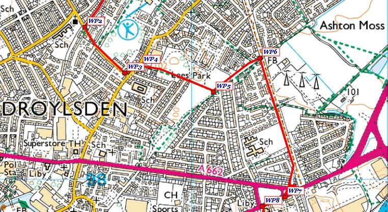
5 At the top of Medlock Street turn left on Market Street (WP3) and then second right into Oldham Street (WP4). Just past the houses, on the right the grass hump was once the site of a play park with swings, a roundabout and slide. Carry on into Lees Park, past the football pitch on the right and the rugby pitch on the left, which once housed East Droylsden Cricket Club and at the end of the path (WP5) turn left. Follow the path along the side of the rugby pitch with wooden fencing on the right and then houses on both sides. The path crosses two other paths and then reaches a metal barrier (WP6). Turn right here on a wider tarmac path with 3 radio masts on the left. This path continues for just under ½ mile where it bears right to lead onto Assheton Avenue. Go to the end of the road and cross the busy A635 Manchester Road (WP7). Turn right, pass Ryecroft Hall on the left then take the first left into Lumb Lane (WP8), Audenshaw. At the bridge over the canal (WP9) (1 hour 40 minutes) turn left onto the towpath and follow it for 1½ miles to the Portland Basin in Ashton-under-Lyne (2 hours 10 minutes). 5


6 6

7 Section 2 Ashton Canal Portland Basin To Lower Higham Visitor Centre, Hyde Miles: 6.7 Time: 2 Hours 25 Minutes Grade: Moderate Starting Point: Portland Basin, Ashton-under-Lyne Grid Reference: SJ The track in red on the maps may appear in places not to be on the actual path. Routes plotted by GPS are generally more accurate than traditional mapping methods, always take the obvious path on the ground. WP in the text and WP symbols on the maps refer to the waypoints where you are the time. First a flat section of the tour visiting the Peak Forest Canal, the River Tame, the Peak Forest Canal again and then climbing up through the countryside south of Gee Cross to the Lower Higham Visitor Centre at Werneth Low. 7

8 At the bottom of Portland Street South cross the bridge over the Ashton Canal and turn right. Go over the cobbled footbridge and at the other side turn 180 right to go under the bridge and onto the towpath of the Peak Forest Canal. The walk doesn't have a very glorious start, passing industrial buildings on both sides and a sewage works. Follow the canal towpath for 1¾ miles passing the Dukinfield swingbridge, a rail bridge, the sewage works, a road bridge and then bridges number 3 and 4. Just after bridge number 4, take the path signposted 'Broomstair/St Annes Road' (WP1) down a cobbled path between two stone walls. At the bottom turn left on the path running alongside the River Tame indicated 'Broomstair' on the signpost (35 minutes). The path goes under the motorway bridge and reaches the A57 Manchester Road in Hyde (WP2). Cross the road, turn right, then first left into Watson Street (WP3). This becomes a dirt lane and passes Broomstair Nurseries on the left, narrows and reaches gates. Go through four spring gates to reach another path (WP4). Turn left here and soon go down steps to rejoin the river. Ignoring any turn offs keep on the main path, bearing left at a fork which brings you to Mill Lane (55 minutes). Cross the road and continue on the main path through Haughton Dale Nature Reserve still walking by the right of the river. 8

9 At over 86 acres it is the largest local nature reserve in Tameside and has many historical and archaeological features. Ignore the signpost for 'Haughton Green' and continue as signposted for 'Haughton Dale'. The path crosses a boardwalk, goes up steps, narrows, crosses another boardwalk, then goes up more steps near a weir on the river at Gibraltar Bridge. It then decends by steps to go through a stile and reach the bridge over the River Tame signposted 'Lower Peak Forest Canal' (the map shows a diversion through the nearby housing estate as the path was closed for repair work when walking the route). Leave the river and head straight ahead signposted for 'Werneth Low'. Shortly go up steps on the left and the cobbled path takes you to the canal (WP5) (1 hour 15 minutes). Turn right and follow the towpath to go under bridge number 9, then at bridge number 10 come off the towpath and cross the bridge (WP6). Go through the stile and follow the well defined path left of Unity Mills. Turn right at the end heading for the bridge over the railway line. Cross the bridge and turn left up Poleacre Lane which leads to the A560 Hyde Road (WP7). Cross Hyde Road and turn left passing the Joshua Bradley public house (1 hour 40 minutes). Just past the pub a stone wall begins (WP8), turn right here, going through the gap in the wall and down into the woods. The paths from this point become very muddy until Birches Farm. 9
.")
10 Cross the stream at the bottom and go uphill on the path above the stream. The path continues through the trees and leads to a stile by a metal gate (a slightly less muddy alternative is to go up to the field and keep to the left of the trees). Cross the stile onto a wide track above the stream below on the right. The short track leads to a gate to Bowlacre Farm on the right. Go left of the gate across Bowlacre Road, and on a very narrow path between a stone wall and a hedge. Go through the gap at the end of the path into the large field. Head in the same direction uphill making for the right of the tree ahead. Just past the tree, cross a stile and head uphill on a faint path in the second short field to another stile by a gate leading into a third field. In the third field keep right by the fence and cross the stile at the top. Turn right, then immediately left taking the path up to Birches Farm. Go through the farm buildings on a now concreted path, cross the stile by a wooden gate and carry on uphill past Lowside Farm to a signpost on Werneth Low Road (WP9). Turn left here following the signposted direction 'Broadbottom', keeping to the path on the right. The left path is a horse track. Pass a triangle of grass on the right at the road junction and go past the Hare and Hounds public house. The path finishes opposite the Hyde Cricket and Squash Club entrance. Carry on, on the road to the Quarry Car Park on Werneth Low Road (2 hours 15 minutes). 10
, taking the signposted direction '½ mile Lower Higham Visitors Centre'.")
11 Opposite the car park entrance go through the stone pillars and take the left path signposted 'Cenotaph ½ mile'. Go through a kissing gate and along the path with a wire fence to the left. In 100 metres go through a kissing gate on the left (WP10), taking the signposted direction '½ mile Lower Higham Visitors Centre'. The path goes downhill by a fence then turns 90 right and continues parallel to Higham Lane. Go though two stiles and two kissing gates and the path leads to the Lower Higham Visitor Centre (2 hours 25 minutes). 11

12 Section 3 Lower Higham Visitor Centre, Hyde To A6018 Mottram Road, Stalybridge Miles: 6.0 Time: 2 Hours 40 Minutes Grade: Moderate Starting Point: Lower Higham Visitors Centre, Higham Lane, Hyde Grid Ref: SJ The track in red on the maps may appear in places not to be on the actual path. Routes plotted by GPS are generally more accurate than traditional mapping methods, always take the obvious path on the ground. WP in the text and WP symbols on the maps refer to the waypoints where you are the time. This section of the tour begins on the heights of Werneth Low Country Park, passing the cenotaph and then giving great views of the Etherow Valley. It continues through Great Wood and Hurst Clough in Broadbottom before proceeding through Mottram and finishing at Matley in Stalybridge. 12

13 Starting at the Lower Higham Visitor Centre, walk to the end of the car park and go through the kissing gate, then go ¼ mile uphill to the cenotaph on Hackingknife. Pass to the right of the cenotaph and at the fork follow the path left to the bottom of the golf course. Go through two gates, then over a stream at Pipers Clough and uphill to where the path ends at a lane at Windy Harbour on Idle Hill (20 minutes). Go directly ahead here steeply downhill on Cock Brow, with the radio masts on the right. At the bottom the lane bears left into the small hamlet of Lumn. Take the path right indicated on the signpost for 'Back Wood' (WP1), which goes down by the side of a house and then becomes tree lined. Keep heading down the path, cross over another track, over a stile and the track eventually leads to a stile to the right of a metal gate. Cross the stile onto open ground and look for a waymarked post near a tree which leads to a another stile and then into Back Wood. The path which is well defined crosses a stile and at the end goes down steps and over a stream, turn right to pass through the gate and then left signposted 'Great Wood' at the lane at Bothams Hall (WP2) (40 minutes). Follow the wide dirt track uphill through a gate then past a small pond on the right, the masts on Idle Hill are to the left. Pass through another gate by a cattle grid, carry on under the line of the pylons and arrive at another gate by a cattle grid near to a signpost (WP3). Take the footpath signposted for 'Great Wood Local Nature Reserve', down to the right at the edge of the wood, with a wire fence to the right. The path turns right by the fence at a corner and then veers left downhil into the wood. Follow the numerous waymarked posts on an obvious path, then cross the metal bridge over a stream and turn right following the wide track. The local nature reserve and ancient woodland at Great Wood is at least 400 years old, is the largest in Tameside and was once a part of the Longdendale Forest. Oak is the dominant tree but the woodland also consists of birch, alder, beech, willow, hazel and holly. It supports a wide range of birdlife, invertebrates and amphibians. 13
. The narrow path runs uphill between fences at the rear of houses, at the top go through a gate back into Great Wood.")
14 Pass through a gap by a gate and go along the left of a fence with farm buildings to the right, this is Leylands Farm at Hodgefold. Turn left at the signpost indicating 'Hurst Clough via Great Wood' (WP4). The narrow path runs uphill between fences at the rear of houses, at the top go through a gate back into Great Wood. Continue uphill to cross a bridge over the railway line (1 hour 10 minutes), then take the left direction by a short length of metal railings and cross over a stile. Turn 90 right in a grassy clearing. Continue in the same direction uphill heading to the right of the houses to a stile. Cross the stile and the short path leads to a tarmac lane. Turn right, then in 10 metres turn left at the signpost for 'Hurst Clough'. The wide track reaches steps which go down into the clough and over a bridge. Turn left uphill with Hurstclough Brook on the left below. At the top turn left again to follow the brook to a footbridge, cross the footbridge and take the middle path ahead and uphill. At the top of the steps take the right fork to a grassy area at the edge of the wood. Go past a metal barrier, a gap in a wooden barrier, then at a signpost for 'Broadbottom Road' take the direction indicated right (WP5). Follow the path, ignoring a narrow turn off on the left, to arrive at Broadbottom Road near the Wagon public house (WP6) (1 hour 40 minutes). Turn right and cross the road, at the footpath sign in 80 metres (WP7) go up steps through a narrow passage between houses to reach a stile. Cross the stile and the narrow path runs between two wire fence then crosses another stile to follow a dry stone wall on the left. At the end of the field cross the stile and another stile in 25 metres, then go left on the dirt lane to stile by a gate (WP8). 14


15 Cross this stile and go through a short field to cross another stile into a larger field, then follow the fence on the right to a stile at the right hand corner of the field. Cross this stile and head slighly left to a stile by a gate on Littlemoor Road (WP9). 15

16 Turn left on Littlemoor Road and follow the road to a farm on the right. Just past the farm turn right into the quaint hamlet of Warhill. Pass the monument, church on the left and school on the right and follow the tarmac road through the cemetery. The tarmac becomes a gravel track and bears left to a gate and stile. Go through the stile and follow the well defined dirt track left and then right to reach the White Hart public house on Market Street, Mottram (WP10) (1 hour 55 minutes). Turn right here, cross the road and go through the traffic lights to Stalybridge Road. At the junction with the A6018 Roe Cross Road, go straight ahead to Old Hall Lane. The lane passes housing and eventually becomes a dirt track. Where it bends 90 right by an enclosed property 'Ivy Dene' take the footpath sign ahead across the field. Head for the stile in the middle and then keep to the hedge on the left in the next field. The path continues past housing on the left and comes out on Old Road. Turn right past Dewsnap Farm House and immediately opposite go down the cobbled path to the A6018. Cross the road, turn left then in 30 metres go right into Edge Lane. Just past the first properties turn right uphill on the wall enclosed track signposted 'footpath'. This track bends right, then right again to eventually reach another track at a three way signpost (WP11). 16


17 Cross the stile on the right into a field keeping to the wall on the right. Go past a property up to the left, through a gap by the gate and into the next field with a pylon to the left. Go over a stile at the end of the field then carry on downhill by the side of a low stone wall to the public footpath signpost and gate on Matley Lane to the A6018 Mottram Road (2 hours 40 minutes). 17

18 Section 4 A6018 Mottram Road To Park Bridge Miles: 9.8 Time: 4 Hours Grade: Hard Starting Point: Wagon & Horses Public House, A6018 Mottram Road, Stalybridge Grid Reference: SJ98966 The track in red on the maps may appear in places not to be on the actual path. Routes plotted by GPS are generally more accurate than traditional mapping methods, always take the obvious path on the ground. WP in the text and WP symbols on the maps refer to the waypoints where you are the time. This section has everything, high moorland, stunning views, and peaceful countryside. The views from the trig point on Hollingworthall Moor cover all of Tameside, as well as parts of Manchester and the High Peak. Audenshaw and the Godley reservoirs can be seen, in fact the only downside is the blue and yellow monstrosity of Ikea in Ashton-under-Lyne. 18

19 Start at Matley Lane by the Wagon and Horses public house. Cross the A6018 Mottram Road and head up Old Road which runs parallel and above the A6018. In 200 metres bear left at the fork for Hobson Moor Road and at the next fork keep left again. Continue for another ½ mile along Hobson Moor Road. Leave the road at the public footpath signpost on the left under the line of the pylons (WP1) (15 minutes). Go through two gates and climb uphill by the deeply rutted track for just under ½ mile keeping to the right hand fence. The track turns 90 left at a signpost (WP2). Follow the track to a spring gated stile by another signpost, and continue uphill in the same direction on the track through the heather. When the path reaches a crossroads (WP3), take the wider path uphill on the right. In ¼ mile this reaches the trig point at Wild Bank Hill on Hollingworthall Moor 399 metres/1309 ft (WP4) (35 minutes). At the trig point, take the path to the right, heading north east across the moor. Within a few minutes go over the stile on the right and head for the post on the top of the hill ahead. Go downhill for a short while and then uphill again heading for another post and stile. Both Higher and Lower Swineshaw reservoirs can be seen ahead to the left. The path follows the ridge and ¾ mile from the trig point telegraph poles appear and a stone wall ahead. Take the stone steps over the wall (55 minutes) and carry on in the same direction, heading slightly downhill with the Swineshaw Reservoirs on the left in the distance. In just under ½ mile go over a stile in a stone wall and through the next stile, near a signpost. Continue downhill and at the next stone wall ignore the waymarked post pointing uphill but keep on the track with the wall to your right and shortly a signpost is reached by three trees. Head left downhill towards the reservoir, passing over a stile, then through a metal gate, to the tarmac access road alongside Upper Swineshaw Reservoir. 19

20 At the end of the road, leave the tarmac lane and take the track ahead, passing by the side of a gate (1 hour 20 minutes) and uphill to another signpost. At this signpost turn right uphill by a demolished concrete structure, and with the reservoir to your right, follow the track left. Just after the left turn and near the self standing gable end of a derelict structure, is a narrow path to a small circular stone memorial and plaque to the local gamekeeper and his wife who died in the 1977 and 1983 respectively. The track continues over the summit and downhill. Soon, Buckton Vale Quarry to the right, and housing at Stalybridge and Mossley, come into view. Hartshead Pike is on the hillside in the distance. The track winds it's way around Harridge Pike and eventually comes to a stile by a metal gate. Go over this and shortly the track meets a lane by a waymarked post for 'Tameside Trail/PBW' (Pennine Bridleway) (WP5) (1 hour 50 minutes). Turn right here and carry on past another waymarked post and then downhill with Buckton Vale Quarry prominent on the hill ahead. Pass another house on the left and the stone track becomes paved on the edges and finishes near a new housing estate by a signpost. Turn left here and go around the rear of the new estate. Just before the mini roundabout go through the gate into Stalybridge Country Park and take either of the forks ahead. This comes out on a dirt track at Swallow Lane, turn right to the main road at Carrbrook and cross the road past the roundabout with a tall stone pillar in the middle and onto another section of Swallow Lane. Pass a school and nursery on the left and then the quaint Moorgate Cottages on the right. At the fork take the right track on Heyheads New Road. 20

21 At the end cross Huddersfield Road (2 hours 10 minutes) and go straight ahead down Staly Road opposite. Pass a row of terraced properties on the left and take the left direction at the signpost for 'Miller Hey/Scout'. This is a muddy track that runs to the rear of housing, ignore a turn off left to the golf course, keep right and the path reaches a cemetery wall. Turn left and follow the wall to a signpost for 'Scout' by a gap in the fencing just as the wall bears right. Go downhill and ahead over a small stream and right of an inspection chamber then up to a dirt track which heads towards outbuildings and a stone house. The track passes the house and past another signpost for 'Scout', goes through a gate and becomes an indistinct path to the left of a fence. A stile is soon reached above the Scout Tunnel on the Huddersfield Canal. Cross the stile and turn left signposted for 'Stalybridge', pass an old quarry, the path then reaches a bridge over the River Tame (WP6) (2 hours 30 minutes). Cross the bridge and turn right on Manchester Road at Mossley. In 150 metres cross the road and take the 'Public Footpath' signed direction through the gap in the stone wall and uphill above the road. At the top turn left up steps at another gap in a stone wall. This goes past garages on the left and a house on the right. At the end of the house cross the stile and take the path 45º right uphill past a small pond. Cross the stile and continue uphill, through the gate at the top and turn left around the rear of the property on the left, Scout Farm, then right following the track which becomes a concreted lane. This finishes at the top of Barngate Drive, take the signposted direction indicated 'Mossley Cross ½ mile' passing left of stables on a narrow path uphill between two wire fences. Go through the gap where the fencing ends and head right uphill. At the waymarked post take the right direction and soon the allotments at Fox Platt can be seen down to the right. Keep to the main path which reaches a stile on Luzley Road at Mossley Cross (2 hours 55 minutes). 21
.")
22 Cross the stile and go to the left of the house ahead to Mossley Road, cross the road and take the first turn left uphill on Broadcarr Lane. Pass a property on the right, then a row of houses and head left at the stile and signpost (WP7). Continue over the field along by the wire fence and a dry stone wall to a stile in the corner of the field. Cross this stile and go past the pylon, with a dry stone wall to the right, stables are soon reached. Cross the stile at the stables and turn right. Go past another stable block and at the lane turn left. Go past the white painted Broadcarr Farm to a signpost for 'Hartshead Pike' which is uphill ahead. The narrow path between two dry stone walls leads to the old tower stump where a left turn leads to the famous old tower at Hartshead Pike 267 metres/876 ft (3 hours 15 minutes). Turn around and go left past the old tower stump to the waymarked 'Oldham Way' (WP8) gap in the stone wall on the left. Head downhill between a dry stone wall and a wire fence, at the bottom cross the stile and then another stile directly ahead signposted 'Lees Road'. The indistinct path goes ahead downhill and bears right to a waymarked post, go downhill here to reach another waymarked post and turn left to cross a mud and stone area which leads to a stile by a three way signpost. Go through the gap in the stone wall signposted 'Park Bridge' along a wire fence on the left passing an enclosed area of old mine shafts on the right. 22

.")
23 This leads to a flatter area and over a short area of boardwalks covering the boggy ground. A stile in the fence is passed and the path bears right and reaches another muddy area down to a stile in the trees. Cross the dip and go up following the path by the fence on the left. At the corner end of the field (WP9) turn right signposted 'Park Bridge 1 mile', along the fence to another stile at the other corner of the field at Port Mahon. Cross the stile and turn left and downhill, cross the grass bridge over the small brook and keep to the right of the brook to a stile at Lees Road (3 hours 30 minutes). Cross the stile and the road, turn left and within 100 metres go through a gap in the stone wall, along the narrow path to cross another stile, then right on the tarmac lane. Just after the left hand bend take the track to the right signposted 'Rocher Vale'. Go over the stile by the gate near a large stone house and turn left following the waymark. Bear left at a flooded area, to pass left of the nearby trees and then head right of the next treeline to pass a waymarked post. Follow the sometimes faint path, over a small boardwalk by another waymarked post and then head north west in the direction indicated to a stile in the trees. Cross the stile, head downhill and this brings you out on the east side of Rocher Vale. Pass the remains of the Rocher Vale coal pit pump house, turn right at the end of the fence (WP10) and cross the bridge over the River Medlock. Keep ahead across the grassed area and turn right and uphill at the lane (WP11). At the top turn left into Dean Terrace and at the end left and down back to the heritage centre at Park Bridge (4 hours). 23
The Mendip Way. Route Directions and Maps Uphill to Wells
 The Mendip Way Route Directions and Maps Uphill to Wells Website: www.mendiphillsaonb.org.uk Email: mendip@mendiphillsaonb.org.uk Facebook & Twitter: @MendipHillsAONB Phone: 01761462338 1 Uphill to Loxton
Leaden Boot Challenge ROUTE INSTRUCTIONS
 Leaden Boot Challenge ROUTE INSTRUCTIONS Section 1 Alstonefield to Ilam From the village hall car park turn R then L and pass through the village keeping to the R to enter Church Street. Pass the Church
Leaden Boot Challenge 2016 ROUTE INSTRUCTIONS
 Leaden Boot Challenge 2016 ROUTE INSTRUCTIONS Section 1 Alstonefield to Ilam (CP2) From the village hall car park turn R then L and pass through the village keeping to the R to enter Church Street. Pass
HARDMOORS 55 RACE ROUTE 2018 HELMSLEY - GUISBOROUGH
 HARDMOORS 55 RACE ROUTE 2018 HELMSLEY - GUISBOROUGH HELMSLEY - CHECKPOINT 1 (WHITE HORSE) 1. Leave RACE START, continue ahead on road (Baxtons Sprunt) At crossroads turn right down Canons Garth eventualy
BURGHCLERE PARISH RIGHTS OF WAY
 BURGHCLERE PARISH RIGHTS OF WAY Full descriptions compiled by Neill & Miggie Bruce All photos Miggie Bruce FP23 on Ridgemoor, looking south, with FP22 crossing by the bush FP1. From C183 Aldern Bridge
CWMGIEDD FROM ABERCRAVE
 Abercrave to Cwmgiedd Walk Page 1 Starting from The Abercrave Inn. Grid Ref: SN 824128 From the Abercrave Inn, an 11.3km (7 miles) walk to the foothills of the Cribarth Mountain, then through forest to
This path goes past an old tree nursery and sawmill. After 800m it crosses over a lane. Follow the bridleway fingerpost into the woods.
 FRENSHAM PONDS 11K CIRCULAR TRAIL 2½ HRS GU10 2DA This magnificent heathland trail starts in woodland and then brings you out onto the open heather of Frensham Common, with no roadwork! The route runs
Walk 1. Cotswold Water Park. Gateway Centre to Cerney Wick, railway track to Lake 6, Gateway Centre.
 Cotswold Water ark Walk way A Swindon/ Cirencester Thomas and Severn Canal way to Cerney Wick, railway track to Lake, way. Spine Road East Hotel Time: hours (short walk km) Distance: km A level walk along
Medway Valley Orchards
 1 Medway Valley Orchards East Farleigh station - Kettle Corner - Farleigh Green - Buston Manor - Yalding - Yalding station Length: 6 ¾ miles (10.9km) Underfoot: Generally, this is a walk on good paths,
Slad over to Pitchcombe and back
 The walk climbs up from Slad over Wickridge Hill, descends to near Pitchcombe, then climbs back over Wickridge hill and round the back of Slad. Page 1 Start Point: SO 8718 0732 The Woolpack, Slad Length:
ID: 283 Distance: 6.2 miles Height gain: 500 Metres Map: Explore OL 19 Contributor David and Chris Stewart
 Walkingworld Wild Boar Fell ID: 283 Distance: 6.2 miles Height gain: 500 Metres Map: Explore OL 19 Contributor David and Chris Stewart Features Birds, Great Views, Hills or Fells Description: Wild Boar
Ardingly Lake, Ouse Valley, Borde Hill
 point your feet on a new path Ardingly Lake, Ouse Valley, Borde Hill Distance: 14 km=9 miles or 12½ km=8 miles Region: West Sussex Author: Hautboy Refreshments: Borde Hill Map: Explorer 135 (Ashdown Forest)
Hay Wood, Rowington and Baddesley Clinton - Warwickshire
 Hay Wood, Rowington and Baddesley Clinton - Warwickshire Starts at Lay-by alongside Hay Wood 2 hours 30 minutes 5.5miles 8.8km Leisurely ID: 0.683 Developed by: John Clift Checked by: Andy Page www.ramblersroutes.org
A Circular Walk from Chapel Carn Brea
 A Circular Walk from Chapel Carn Brea 4.3 Miles A Walk Visiting Five Historic Ancient Sites This circular walk offers the possibility of several alternatives, depending on the walker s available time and
Hindhead, Keffolds Copse and Gibbet Hill
 point your feet on a new path, Keffolds Copse and Gibbet Hill Distance: 6 km=4 miles Region: Surrey Author: Schwebefuss Refreshments: Punch Bowl Café moderate walking Date written: 14-apr-2015 Last update:
Beautiful Walks from the Blue Ball Inn
 Walk No. 5 RIVER VALLEYS AND MOOR Countisbury, Watersmeet, Hillsford Bridge, Cheriton, Shilstone Hill, Rockford and Chiselcombe. 8.5 MILES APPROX. Walking time four and a half hours approx. OS 1;25,000
The 34 th Poppyline Marathon
 The 34 th Poppyline Marathon Saturday 9th June 2018 - Route Description Emergency number: 07906 404673 or 07597 052572 Ahd - Ahead BL - bear left BR - bear right BW - bridleway Cont - continue FB - footbridge
Ystwyth and Rheidol Bridleway Routes. Route 2:Llanilar Circular
 Ystwyth and Rheidol Bridleway Routes Route 2:Llanilar Circular Route overview and terrain: A long circle using connecting ridges with fine views to link the Rheidol and Ystwyth river valleys. The route
HARDMOORS ROUTE DESCRIPTION
 HARDMOORS 60 2016 ROUTE DESCRIPTION RACE START (GUISBOROUGH) - CHECKPOINT 2 (SALTBURN) DISTANCE 9 MILES CUT OFF TIME 1030 GRID REF OS 666 208 1. Leaving the Sea Cadets Hall, turn left onto the road and
Pontfadog. Walk A. Walk A
 Walk A A Bird s eye view of the village 2km. (1 1 /2 miles); height gain 45m. (150ft) about 45 minutes. Six minutes walk along the main road towards Glyn Ceiriog reach a signpost to Llwynmawr. Take the
Description for the Round Rotherham 8 December 2007
 Directions: L left R right ½L, ½R half left, half right X cross X Rds cross roads SA straight Codes: BR bridge FP footpath FB footbridge RWY railway CP car park RD road Description for the Leave Event
GRINDLEFORD GALLOP 2018
 GRINDLEFORD GALLOP 2018 Route Information The Grindleford Gallop follows a fixed 21 mile route through the lanes and paths of Derbyshire. All competitors must follow this route. An OS map of the area with
Mersey Valley Timberland Trail
 Route Pack Page 1 Route Summary A long distance linear walk on roads and country paths linking town and countryside to parks, woodlands and other open spaces. Grade Distance Accessibility Allow Start Map
Cragg Vale to Todmorden
 Cragg Vale to Todmorden Map Co-Ordinates : SE 002232 The Te Duem Stone near Stoodley Pike symbolises a long tradition of wayfaring. Crossing the the Pennine Way, the route drops down towards Lumbutts and
Singleton and the South Downs
 point your feet on a new path Singleton and the South Downs Distance: 13½ km=8½ miles easy walking with a few steeper sections Region: West Sussex Author: Hautboy Refreshments: Singleton, Hill Barn Date
The Copper Horse Lodge, Windsor Park George III statue and view of Windsor Castle Andy Oakes Julian P Guffogg Don Cload
 Trail Activity Area Type(s) Author Distance Ascent Location : BRKSTR0008 : Walk : Windsor and the South East : Country Escape : Andy Oakes : 5 miles / 8.1 km : 239 feet / 73 metres : SU947727 / SL4 2BT
Penn Common and Bramshaw Wood
 Trail Activity Type Terrain Author Distance Ascent Location : HAMPTR0025 : Walk : Pub : Towpaths and Cycle Tracks : Anne-Marie Edwards : 5.3 miles / 8.5 kms : 381 feet / 116 metres : SU253173 / SP5 2BZ
Bewl Water & the High Weald
 1 Bewl Water & the High Weald Stonegate station - Stonegate - Wallcrouch - Newbarn - Cousley Wood - Wood's Green - Wadhurst station Length: 9 ½ miles (15.3km) Underfoot: Large portions of this path are
Chevening and the North Downs
 1 Chevening and the North Downs Dunton Green station - Chipstead - Chevening - Knockholt - Hawley's Corner - Botley Hill - Oxted station Length: 12 ¼ miles (19.7 km) Underfoot: Portions of the walk are
Beamers Trail. Walk No.1. 6 miles. (easy with some moderate ascents and descents)
") Beamers Trail Walk No.1 6 miles (easy with some moderate ascents and descents) 1 BEAMERS TRAIL 6 miles (easy with som WALK The Warpers Trail forms part of the long distance Witton Weavers Way. This is
Beamers Trail Walk No.1 6 miles (easy with some moderate ascents and descents) 1 BEAMERS TRAIL 6 miles (easy with som WALK The Warpers Trail forms part of the long distance Witton Weavers Way. This is
Ranmore Common and Polesden Lacey
 point your feet on a new path Ranmore Common and Polesden Lacey Distance: 9½ km=6 miles Region: Surrey Author: Fusszweig Refreshments: Polesden Lacey easy walking Date written: 20-dec-2016 Last update:
Britain s oldest surviving water-balanced cliff lift
 44 3.6 Saltburn by the Sea to Sandsend Map panels 3 and 4 Distance 17 miles (27½ km) Terrain mostly grass and field paths which can be muddy; some pavement, beach and shore Grade undulating route, with
Mapledurham, Gallowstree and Shepherd s Green
 Mapledurham, Gallowstree and Shepherd s Green Pangbourne station Mapledurham Gallowstree Common Satwell Shepherd s Green Grey s Court Henley-on-Thames Length: 15 ½ miles (24.8km) Underfoot: Minor roads
Hadleigh Castle and Chalkwell Oaze
 1 Hadleigh Castle and Chalkwell Oaze Benfleet station Hadleigh Park Hadleigh Castle Leigh-on-Sea Chalkwell station A short stroll through the lush woods of Hadleigh Park high above the Thames-side marshes,
Wicklow Mountains Path Survey
 Wicklow Mountains Path Survey Ballinacor Croaghanmoira Fananierin Start to Finish: T 11723 86602 to T 11175 89057 Altitude (lowest highest): 385m 664m Weather: Hot Access: Coolgarrow forest entrance Surveyed
Ivinghoe Beacon and the Grand Union
 1 Ivinghoe Beacon and the Grand Union Cheddington station - Horton Wharf - Ivinghoe - Ivinghoe Beacon - Bridgewater Monument - Aldbury - Tring station Length: 11 ¼ miles (18.3km) Underfoot: The first mile
Sponsored by. statestreet.com
 /STATESTREETISLANDWALK #ISLANDWALKJSY Sponsored by statestreet.com Important Information If you forget everything else PLEASE remember the following.» Remember to check OUT of every checkpoint» If you
BISHOPSTONE CIRCULAR WALK
 BISHOPSTONE CIRCULAR WALK 4½ miles (7¼ km) - allow 2 hours (see maps on final pages) Introduction This walk is within the North Wessex Downs Area of Outstanding Natural Beauty and starts from the small,
START - UPHILL BEACH. (tidal!) The West Mendip Way is route-marked with these round blue signs
 The West Mendip Way is route-marked with these round blue signs") START - UPHILL BEACH Start Times: 10:30 11:15 12:00 Please allow sufficient time to check in with the marshals Start on the beach at the high water line (tidal!) The West Mendip Way is route-marked with
START - UPHILL BEACH Start Times: 10:30 11:15 12:00 Please allow sufficient time to check in with the marshals Start on the beach at the high water line (tidal!) The West Mendip Way is route-marked with
3.1 Bowness-on-Solway to Carlisle
 3.1 Bowness-on-Solway to Carlisle Map panel 1 Distance 15 miles (24 km) Terrain minor roads, tracks, field paths and riverside footpath, muddy in places Grade easy, with gentle gradients on undulating
Lewes and the South Downs
 point your feet on a new path and the South Downs Distance: 0 km=1½ miles moderate walking with long easy stretches Region: East Sussex Author: Hautboy Refreshments: Date written: 8-apr-013 Map: Explorer
Walk 1: Highfield, Lob Wood and The River Wharfe
 Walk 1: Highfield, Lob Wood and The River Wharfe Start: The Hen Pen Garden, Main Street, Addingham LS29 0NS, SE 077 498. Alternative Start: Near Bolton Bridge SE 071 525 (see page 6). Full walk: 4.5 miles
Friday Street, Leith Hill, Holmbury Hill
 point your feet on a new path Friday Street, Leith Hill, Hill Distance: 12 km=7 miles easy-to-moderate walking + optional tour of Hill: 1½ km=1 mile Date written: 27-oct-2011 Region: Surrey Author: Schwebefuss
Chess & Gade. Chalfont & Latimer Station - Latimer - Chenies - Sarratt - Kings Langley Station. Length: 8 ¾ miles (14.25km)
") 1 Chess & Gade Chalfont & Latimer Station - Latimer - Chenies - Sarratt - Kings Langley Station Length: 8 ¾ miles (14.25km) Underfoot: Well-trodden paths, mainly firm in all weather conditions, though
1 Chess & Gade Chalfont & Latimer Station - Latimer - Chenies - Sarratt - Kings Langley Station Length: 8 ¾ miles (14.25km) Underfoot: Well-trodden paths, mainly firm in all weather conditions, though
The Sudbury Branch Walks 1-4
 The Sudbury Branch Walks 1-4 Sudbury Branch Walks From Sudbury to Marks Tey The gentle declivities, the luxuriant meadow flats sprinkled with flocks and herds... the sound of water escaping from the mill
Bentley station - Alice Holt Forest - Frensham Great Pond - Rushmoor - Pitch Place - Gibbet Hill - Haslemere station
 1 Devil s Punch Bowl and Surrey Heaths Bentley station - Alice Holt Forest - Frensham Great Pond - Rushmoor - Pitch Place - Gibbet Hill - Haslemere station Length: 13 ¾ miles (22.0 km) Underfoot: Almost
Aeron & Arth walks 4 walks for all the family to enjoy
 Aeron & Arth walks walks for all the family to enjoy Please take note that the maps illustrating these walks are intended as a rough guide only. You should use the most recent version of the relevant Ordnance
Woodland Walk If you enjoyed this walk there are two others available in the same area.
 The Woodland Walk 11-12 kilometres (7-8 miles) 4-5 hours Terrain: some easy hills Can be slippery when wet 5 stiles Unsuitable for a pushchair/wheelchair Uses OS map 197 Parking: Pulborough Station and
Beautiful Walks from the Blue Ball Inn
 Walk No. 2 WINSTONS WALK Countisbury, Wind Hill, Watersmeet, Ash Bridge and Winston s path. 5 Miles approx. Walking time- Two and a half hours approx. (Not including Breaks) OS 1:25,000 Sheet 64/74 Lynton
The Bridestone Rocks from Lydgate
 Print this page Back to results The Bridestone Rocks from Lydgate Ancient tracks and gritstone outcrops, with terrific views of the steepsided Cliviger Valley. Distance 5 miles (8km) Minimum time 2hrs
Fetcham Downs and Bocketts Farm A magical teashop walk
 point your feet on a new path Fetcham Downs and Bocketts Farm A magical teashop walk Distance: 3 km=2 miles or 4 km=2½ miles Region: Surrey Author: Fusszweig Refreshments: Bocketts Farm easy walking Date
River Isla B951. Diarmid s Tomb
 3. 4 Spittal of Glenshee to Kirkton of Glenisla Distance 14.6 miles 23.5 km Terrain mainly on rough moorland path with boggy bits and stream crossings, then heading east along at the B951 for 2.5 miles,
Warpers Trail. Walk No miles. (Easy with a few, short steep ascents)
") Warpers Trail Walk No.4 8.5 miles (Easy with a few, short steep ascents) 4 WARPERS TRAIL 8.5 miles (easy with a WALK The Warpers Trail forms part of the long distance Witton Weavers Way. This walk combines
Warpers Trail Walk No.4 8.5 miles (Easy with a few, short steep ascents) 4 WARPERS TRAIL 8.5 miles (easy with a WALK The Warpers Trail forms part of the long distance Witton Weavers Way. This walk combines
Reigate Hill and Gatton Park
 point your feet on a new path Reigate Hill and Gatton Park Distance: 11½ km=7 miles easy-to-moderate walking or 2 walks of 6½ km=4 miles and 5½ km=3½ miles Region: Surrey Author: Schwebefuss Refreshments:
A Tour of the Valle del Gizio
 Walk 25 A Tour of the Valle del Gizio Walking time 5hrs 30mins (4hrs if Colle Mitra is omitted) Difficulty 2 (likely to be snowbound in winter months); 1 (if Colle Mitra is omitted) Ascent/descent 570m/570m
Gomshall station - Abinger Hammer - Abinger Common - Friday Street - Leith Hill - Coldharbour - Holmwood station
 1 To Leith Hill Gomshall station - Abinger Hammer - Abinger Common - Friday Street - Leith Hill - Coldharbour - Holmwood station Important note: this walk cannot currently be done wholly by train on a
Self-Guided Walk Malham, Gordale and Malham Tarn
 Self-Guided Walk Malham, Gordale and Malham Tarn Combine all the major geological attractions of Malham in this walk and hopefully leave enough time to enjoy the cafes, pubs and shops of the village. Malham
Aston Rowant Discovery Trail
 The walk was developed by Aston Rowant Parish Council. The Trail is stile-free and fully way-marked. The circular route is 5.3m but with the extension to a pub and hotel 6.2m. Key Main Aston Rowant Discovery
Kingley Vale and the Downland Churches
 point your feet on a new path Kingley Vale and the Downland Churches Distance: 21 km=13 miles or 10½ km=6½ miles Region: West Sussex Author: Hautboy Refreshments: Stoughton, Walderton moderate walking
Self-Guided Walk Langdale Pikes. Start & Finish: NT car park (free to members) at Sticklebarn - on the right just beyond the New Dungeon Ghyll hotel.
 at Sticklebarn - on the right just beyond the New Dungeon Ghyll hotel.") Self-Guided Walk Langdale Pikes Key Information These mountains form a collection of spires and cliffs on the north side of Langdale. This walk visits four of the main tops Pavey Ark, Harrison Stickle,
Self-Guided Walk Langdale Pikes Key Information These mountains form a collection of spires and cliffs on the north side of Langdale. This walk visits four of the main tops Pavey Ark, Harrison Stickle,
Freefolk and Whitchurch
 Trail Activity Type Terrain Author Distance Ascent Location : HAMPTR0026 : Walk : Tea Shop : Towpaths and Cycle Tracks : Jean Patefield : 5.6 miles / 9 kms : 377 feet / 115 metres : SU487488 / RG28 7NN
White Horse Trail Route directions (Clockwise) split into 10 section with an alternative for the Alton Barnes to Cherhill section
 split into 10 section with an alternative for the Alton Barnes to Cherhill section") White Horse Trail Route directions (Clockwise) split into 10 section with an alternative for the Alton Barnes to Cherhill section S1 White Horse Trail directions Westbury to Bulkington Maps: OS Explorer
White Horse Trail Route directions (Clockwise) split into 10 section with an alternative for the Alton Barnes to Cherhill section S1 White Horse Trail directions Westbury to Bulkington Maps: OS Explorer
Tacklers Trail. Walk No miles. (A walk with a couple of short steep slopes and some rough moorland paths)
") Tacklers Trail Walk No.3 9.5 miles (A walk with a couple of short steep slopes and some rough moorland paths) WALK 3 TACKLERS TRAIL 9.5 miles (moderate wi 1. Sunnyhurst Visitor Centre The Warpers Trail
Tacklers Trail Walk No.3 9.5 miles (A walk with a couple of short steep slopes and some rough moorland paths) WALK 3 TACKLERS TRAIL 9.5 miles (moderate wi 1. Sunnyhurst Visitor Centre The Warpers Trail
Countryside Trails Dunkeld
 R A N G E R S E RV I C E Countryside Trails Dunkeld WELCOME Welcome to this southern end of Atholl Estates. The countryside here is a wonderful blend of lochs, woodland and heather moor. There is a large
COSTA BLANCA MOUNTAIN WALKERS - WALK DESCRIPTION. Visit for more walks descriptions in Spain
 Visit www.walksinspain.org for more walks descriptions in Spain Walk description originally prepared by:- Ralph Phipps Last Updated 15 th July 2016 Title of Walk Location of Start (include name of nearest
Map: Landranger #27 Forres and Nairn and 36 Grantown and Aviemore
 THE DAVA WAY This is a newly created long distance route that runs from Forres to Grantown, mostly following the old railway line. You will need to detour around a couple of sections that are not really
Gomshall station - Abinger Hammer - Abinger Common - Friday Street - Leith Hill - Coldharbour - Holmwood station
 1 To Leith Hill Gomshall station - Abinger Hammer - Abinger Common - Friday Street - Leith Hill - Coldharbour - Holmwood station Important note: this walk cannot currently be done on a Sunday due to the
Minecraft village. Explore a curious village that tells the story of our Victorian textile boom. Directions
 Trail Minecraft village Explore a curious village that tells the story of our Victorian textile boom Time: 1-1½ hrs Distance: 2 miles Landscape: urban Thornton, just four miles from the centre of Bradford
Basingstoke Canal and Dogmersfield
 point your feet on a new path? Basingstoke Canal and Dogmersfield Distance: 11 km=7 miles easy ing or 2 s of 7½ km=4¾ miles and 5¼ km=3¼ miles Region: Hampshire Author: Botafuego Refreshments: The Barley
river point your feet on a new path
 river point your feet on a new path Frensham and Bourne Wood Distance: 13 km=8 miles or 11 km=7 miles easy walking with a few steep gradients Region: Surrey Author: Schwebefuss Refreshments: Shortfield
s point your feet on a new path
 s point your feet on a new path Arundel: Park, Hills and Forests Distance: 20 km=12½ miles Region: West Sussex Author: Hautboy Refreshments: Arundel, Houghton, Whiteways Lodge moderate walking Date written:
School Bus Services in the Tameside Area. September 2017 to July 2018
 School Bus Services in the Tameside Area September 2017 to July 2018 Journeys in this leaflet operate on schooldays only, unless otherwise stated. Although provided primarily for school students, members
Merritts Traverse. 1928m
 Merritts Traverse 3 hrs Hard track 5.8 km Circuit 4 167m This walk starts with a scenic journey to the top of the hill on the chairlift. Starting along Merritts Nature walk, this walk soon detours down
A leisurely one mile stroll through the history of Aldershot s Manor park, considered by many as the most attractive and pleasant parts of our town.
 Figure 1 Entrance to Park from the Aldershot Green/Churchill road end A leisurely one mile stroll through the history of Aldershot s Manor park, considered by many as the most attractive and pleasant parts
Torrance. Mapped Heritage. The following maps demonstrate the spatial strategy for the Torrance trails. Trail themes
 Torrance The following maps demonstrate the spatial strategy for the Torrance trails. The heritage and proposed trails are presented on two maps per area: Map 2A - Existing heritage locations Map 2B -
WALKS AROUND WOODHURST
 WALKS AROUND WOODHURST With Walks To Woodhurst from North St. Ives Woodhurst is situated on the verge of an elevated tract of table land four miles north of St. Ives. Its footpaths vary from leafy lanes
Approximate distance: 7.5 miles For this walk we ve included OS grid references should you wish to use them.
 Approximate distance: 7.5 miles For this walk we ve included OS grid references should you wish to use them. 6 5 7 8 4 1 2 Start End N 3 W E S Reproduced by permission of Ordnance Survey on behalf of HMSO.
Beachy Head and Eastbourne
 point your feet on a new path Beachy Head and Eastbourne Distance: 2 km=4½ miles Region: East Sussex Author: Stivaletti moderate walking Date written: 25-jun-200 & 6-jun-205 Last update: 28-feb-208 Refreshments:
C E N T R A L C A T S K I L L S
 120 C E N T R A L C A T S K I L L S Central Catskills Once out of the southern parts of the Catskills, the Long Path enters the more well traveled and civilized regions. The trail joins the Devil s Path,
Drive and Stop Routes
 Drive and Stop Routes Limantour Road 1 - easy and likely productive. From Bear Valley Visitor Center drive back out and turn left onto Bear Valley Rd. Turn left at Limantour Road (the first road). Drive
School Bus Services in the Tameside Area. September 2016 to July 2017
 School Bus Services in the Tameside Area September 2016 to July 2017 Journeys in this leaflet operate on schooldays only, unless otherwise stated. Although provided primarily for school students, members
Congewai Track Head (East) to Watagan Headquarters
 to Watagan Headquarters") Congewai Track Head (East) to Watagan Headquarters 7 hrs Hard track 17.2 km One way 4 973m This full day walk starts from the Congewai valley trackhead (east) and follows the Great North Walk up into the
Congewai Track Head (East) to Watagan Headquarters 7 hrs Hard track 17.2 km One way 4 973m This full day walk starts from the Congewai valley trackhead (east) and follows the Great North Walk up into the
West Wirral (Dee Estuary)
") View of Hilbre Island from West Kirby with walkers at low tide. West Wirral (Dee Estuary) West Kirby is the start of the 12 mile long Wirral Way, the backbone of Wirral Country Park, the old Hooton to
View of Hilbre Island from West Kirby with walkers at low tide. West Wirral (Dee Estuary) West Kirby is the start of the 12 mile long Wirral Way, the backbone of Wirral Country Park, the old Hooton to
Distance: 18 km=11 miles or 12½ km=7½ miles or 9 km=5½ miles
 point your feet on a new path The Devil s Dyke Distance: 18 km=11 miles or 12½ km=7½ miles or 9 km=5½ miles Region: West Sussex Author: Hautboy Refreshments: Devil s Dyke, Fulking, Poynings moderate ing
Broxbourne Woods Brickendon, Ermine Street, Wormley West End
 point your feet on a new path Broxbourne Woods Brickendon, Ermine Street, Wormley West End Distance: 10 km=6 miles (+ 1.2 km=0.8 mile for north pub) easy walking or two walks of 7 km=4½ miles (south) and
Bentley and Isington Mill Lower Froyle: The Anchor
 point your feet on a new path and Isington Mill Lower Froyle: The Anchor Distance: 12 km=7 miles Region: Hampshire Author: Botafuego Refreshments: Lower Froyle, easy walking Date written: 6-may-2012 Date
Scenic Railway to Ruined Castle
 Scenic Railway to Ruined Castle 7 hrs 30 mins 12.4 km Return Hard track 4 963m This is a very popular, full day walk, in the Katoomba Area, offering great views of the valley. The walk follows the edge
The. History Walk. WWII Armaments factory
 The History Walk WWII Armaments factory 4.8-6.5 kilometres (3-4 miles) 2.5-3.5 hours Terrain: easy Can be slippery when wet No stiles Unsuitable for a pushchair/wheelchair Uses OS map 197 Parking: Pulborough
Wicklow Mountains Path Survey
 Wicklow Mountains Path Survey Glenmacnass Tonelagee Start to Finish: O 114 030 to O 085 016 Altitude (lowest highest): 370m 817m Weather: Sunny day, hot Access: Military Road, Glenmacnass Surveyed by:
Delamere Loop. The. Useful Businesses Equestrian Escapes Tailor-made horse riding holidays in Cheshire. Tel:
 The Loop Accommodation Providers Akesmere Bed & Breakfast OS Grid Ref. SJ589/669 B&B for horse and rider. Chester Road, Little, Tarporley, Cheshire CW6 9ER Tel: 01829 760348 www.akesmerefarm.co.uk Useful
A novel character. Discover what shaped the landscape that so inspired the Brontës. Directions
 Trail A novel character Discover what shaped the landscape that so inspired the Brontës Time: 1-1 ½ hrs Distance: 1 ½ miles Landscape: rural The small village of Haworth in West Yorkshire is most famous
The Hundred Parishes
 The Hundred Parishes Walks from railway stations number 3 3 miles (5kms) circular walk from Stansted Mountfitchet Start & finish: Stansted Mountfitchet station. Ordnance Survey Explorer Map 195. Grid Reference:
Events April October 2014
 Tameside Metropolitan Borough Council Events April 2014 - October 2014 @tmbc_culture www.tameside.gov.uk/culturalservices Welcome to Tameside s Cultural Events We hope you will find plenty to enjoy in
UMASS CROSS-COUNTRY Trails
 UMASS CROSS-COUNTRY Trails 1) EGG (43 min) (A) From Cage proceed to North Pleasant street (by campus pond). Make left and head toward LGRT and pass School of Education. Pass Puffton Apt complex (on left)
Jerusalem Bay Track (Cowan to Brooklyn)
") Jerusalem Bay Track (Cowan to Brooklyn) 5 hrs 30 mins 13.4 km One way Hard track 4 654m This Cowan to Brooklyn Station walk is a popular section of the Great North Walk, with scenery ranging from foreshore
Jerusalem Bay Track (Cowan to Brooklyn) 5 hrs 30 mins 13.4 km One way Hard track 4 654m This Cowan to Brooklyn Station walk is a popular section of the Great North Walk, with scenery ranging from foreshore
Wondabyne station to Somersby Store
 Wondabyne station to Somersby Store 10 hrs Hard track 26.2 km One way 4 1164m This walk, following a section of the Great North Walk, starts from the Wondabyne train station and winds north, into the Brisbane
Firle, Alciston and the South Downs
 point your feet on a new path Firle, Alciston and the South Downs Distance: 16 km=10 miles Region: East Sussex Author: Hautboy Refreshments: Alciston, Firle moderate walking with long easy stretches Map:
San Miguel to Caserio de la Hoya Circular (San Miguel)
") Tenerife Sur: Short Walks Under 10 km San Miguel to Caserio de la Hoya Circular (San Miguel) Route Summary An informative and scenic walk back in time from San Miguel to below El Roque, overlooking the
Tenerife Sur: Short Walks Under 10 km San Miguel to Caserio de la Hoya Circular (San Miguel) Route Summary An informative and scenic walk back in time from San Miguel to below El Roque, overlooking the
West Hoathly, Balcombe & Bluebell Railway Steam and Seed Bank
 point your feet on a new path West Hoathly, Balcombe & Bluebell Railway Steam and Seed Bank Distance: 8 km= miles or walks of 9½ km=6 miles and 0 km=6½ miles Region: West Sussex Author: Stivaletti Refreshments:
Skipton Castle Woods Accessibility Statement November 2016
 Skipton Castle Woods Accessibility Statement November 2016 Purpose: This accessibility statement outlines the available facilities and access information for Skipton Castle Woods. Welcome We, the Woodland