Agenda. Part I! Trailbuilding! Foundations" Part II! Essential Elements! of Sustainable Trails" Part III # Designing! Sustainable Trails"
|
|
|
- Primrose Hoover
- 5 years ago
- Views:
Transcription
1
2

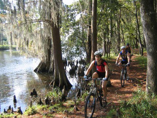
3 Agenda Part I! Trailbuilding! Foundations" Part II! Essential Elements! of Sustainable Trails" Part III # Designing! Sustainable Trails"


4 IMBA"s mission is to protect# create# and $ enhance quality trail experiences for $ mountain bikers worldwide%$

5 IMBA Trail Care Crews have led more than $ &#''' trailbuilding projects$ Hospital Hill# WA$


6 Trailbuilding Foundations$!Historical Perspective$!Modern Perspective$!Sustainable Trails$ Warton# NJ$

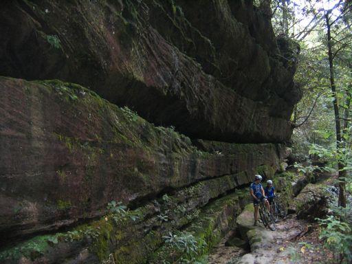
7 Hungry Mother SP# VA$

8 Fingale# Italy$

9 Wales# Great Britain$

10 CBC Trail# British Columbia$
$!Minimal user con*ict (Social)$!")
11 A sustainable trail allows users to enjoy a natural area with:$! Minimal impact to the ecosystem (Environmental)$!Minimal user con*ict (Social)$! Minimal maintenance (Economic)$


12 One of the most common causes of trail failure is erosion$ Trail erosion is caused by a combination of trail use# water# wind and gravity%$


13 Examples of+ Trail+ Failures$
+.")
14 Think Water$ &%! Water always goes downhill+,% With enough volume andor velocity water will move soil (erosion)+.% Water doesn"t like to change directions+ /% Water clings to surfaces and itself$

15 Water starts to channelize gaining volume-velocity and picking up sediment$ An obstacle abruptly changes the direction of the water causing it to dump sediment behind the object$ The water continues to erode soil on the down hill side of the obstacle$


16 Fall Line$! The steepest! route of descent! down a slope$! Water will travel+ down the fall line$ Cattle trails# NE $

17 The Contour Trail$!Erosion resistant and low maintenance$!keeps users on the trail$!keeps water o0 the trail$


18 Sheet Flow$


19 Fall Line$ Contour$

20 Essential Elements of Sustainable Trails$ Lykens# PA$


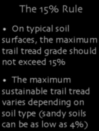
21 An Understanding of Grade$ Rise$ 10 Feet$ Grade$ 10%$ Run$ 100 Feet$ x 100 = 10%$ Grade = 10%$


22 (DEGREES)$ % (PERCENT)$

23 2 Ingredients of Sustainable Trail Design$ 1&! The Half Rule$ 1,! The &23 Rule$ 1.! The &'3 Rule$ 1/! Grade Reversals$ 12! Outslope$

$!")

24 1 &! The Half Rule$! Keep the grade of the trail less than half the grade of the side slope (fall line)$! This keeps water from diverting down the tread + Australia$


25 Measure the side slope (fall line)$ Sideslope 4 &53$,$ Max% Trail Tread Grade 4 63$ Las Vegas# NV$

26 Las Vegas# NV$

27 1,! The &23 Rule $ Maximum Sustainable Grade Rule$

28 Ninham Mtn# NY$


29 Exceptions to the &23 Rule $ Natural Rock$ Armored Sections$ Built Structures$

30 1.! The &'3 Rule$


31 The &'3 Rule:$!When laying out trail# keep the overall grade under &'3$!This allows up to &23 grade trails to accommodate grade reversals and avoid obstacles$ Rise 4 &$ Run 4 &'$ GRADE4$ &$ &'$

32 1/! Grade Reversals$ Creating Watersheds Along the Trail$
33 Grade Reversals$ Grade Reversals

34 Grade reversals also help create a complete trail experience$ MacKenzie River Trail# OR$


35 12! Outslope$ Outslope Trail tread should be outsloped by 23 for sheet $ow of water$

36 Designing Successful Trails Hospital Hill# WA$


37 Trail Users$ Know Your Trail Users TRAIL RUNNERS$ EQUESTRIANS$ HIKERS$ MOUNTAIN BIKERS$


38 Control Points$ Deciding Where the! Trail Should Go$ Positive Control Points$ Negative Control Points$

39 Scenic Overlooks$ Unique Natural Features$ Historic Sites$ Water$


40 Low!lying & Environmentally$ Sensitive Areas$ Fall Lines$ Examples of Negative Control Points$


41 Trail Flow" Understanding *ow can help reduce erosion and user con*ict$
42 Open and Flowing Trail Flow
43
44 Tight and Technical

45
46 Poor Flow - abrupt transitions from one type of flow to another.

47 Corrals and Chokes! Tools for Blending $
48 Corral Rocks and Chokes$ Choke Corralling rocks. New more enjoyable trail. Old straight trail.

49 Conceptualize Loops" Conceptualize Loops Massanutten Ridge# VA$
50 Stacked Loop Trail System$
51 Stacked Loop Trail System$
52 Stacked Loop Trail System$

53 Core Loop $

54 Stacked Loop Trail System$


55 Hybrid Loop$ Optional lines add challenge but preserve 7easy line8$

56 Stacked Loop Trail System$

57 Outer Loop! Tight & Technical$
58 Stacked Loop Trail System$


59 Skills+ Parks$ Presque Isle# ME$ Nature Walk+ Trails$
60 Stacked Loop Trail System$

61 Conclusion / Wrap-Up! Environmental!Enjoy nature with minimal impact! Social Facets of Sustainability!Minimal user conflict!greater constituency! Economic!Decreased maintenance costs!tourism dollars
62 The End!
APPENDIX D: SUSTAINABLE TRAIL DESIGN. APPENDICES Town of Chili Parks and Recreation Master Plan Update
 APPENDIX D: SUSTAINABLE TRAIL DESIGN APPENDICES Town of Chili Parks and Recreation Master Plan Update Sustainable Trail Construction Sustainable trails are defined by the US Forest Service as trails having
Minnesota Off-Road Cyclists
 Minnesota Off-Road Cyclists MORC Mission Minnesota Off-Road Cyclists is a nonprofit volunteer organization dedicated to safeguarding the future of mountain biking in Minnesota through the promotion of
2. STAKEHOLDER FEEDBACK // What We Heard
 1. QUARRY ROAD TRAIL // Welcome to the Information Session PROJECT DESCRIPTION WHY WE ARE HERE Quarry Road Trail is a popular commuter trail and recreational area for Calgarians. 1. To report citizen feedback
General Issues with the Portland Parks & Recreation Trail Design Guidelines for Portland s Park System ( Portland Guidelines )
") Why the City of Portland s current Trail Design Guidelines (2009) are substandard & need to be updated. For purposes of this discussion we will be referring to the following natural surface trail guidelines:
Why the City of Portland s current Trail Design Guidelines (2009) are substandard & need to be updated. For purposes of this discussion we will be referring to the following natural surface trail guidelines:
Course 205. Tread Re-Construction
 PCTA Trail Skills College Curriculum Instructor Planning Guide This course goes beyond a triage approach covered in Course 203 Waterbars and Checks because reconstruction indicates a more thorough restoration
Evergreen Trail School
 Evergreen Trail School Making Washington a Better Place to Ride Preston, WA & Tiger Mt. Sat, April 9, 2015 8-11:45am: Classroom 11:45-12:45pm: Lunch 12:45-4pm: Trail Work Classroom Agenda Introduction
Trail Master Plan. Hungry Mother State Park
 Trail Master Plan For Hungry Mother State Park Prepared for Virginia State Parks Presented by Trail Dynamics, LLC PO Box 664 Cedar Mountain, NC 28719 www.traildynamics.com 1 1 Table of Contents Introduction
KENNESAW MOUNTAIN TRAIL CLUB WORKDAY
 WORKDAY 2-10-18 1 Trail ambassadors or others see next page. 1 work sites TOOLS 15 1 3 1 2 SCHEDULE: 7:15 Start load tools; Send registration stuff out 8:00 Send tools to grassy area near trail head. 8:15
New Mountain Bike Trails Proposal. Wharncliffe Woods- Sheffield
 New Mountain Bike Trails Proposal. Wharncliffe Woods- Sheffield Overview We propose to create two new cross country trail within Wharncliffe woods, one to replace the existing black trail, which has become
Kennesaw Mountain Trail Club. Trail Skills Workshop ~ Dips and Drains. Presented by: Jay M Dement
 Kennesaw Mountain Trail Club Trail Skills Workshop ~ Dips and Drains Presented by: Jay M Dement KEY CONCEPTS: Control Erosion and Users Where Do Trails Come From, and How Do They Work: Concept of trail
Red Grade Trails Community Conversations Critiques w/fact Checks, and Add l Summaries
 Red Grade Trails Community Conversations Critiques w/fact Checks, and Add l Summaries 5-20-2015 Project Critiques with Fact-Checks 1. There has been a general lack of outreach, public engagement, and transparency
Desert Trails. Designing and Building Trails in a Harsh and Demanding Environment. By Mark Flint
 Desert Trails Designing and Building Trails in a Harsh and Demanding Environment By Mark Flint About the Author Mark Flint began building trails in Oregon as a volunteer in the early 1990s. He has attended
Trail Assessment Report
 Trail Assessment Report Trail Options for the Bear Creek Canyon located in Pikes Peak Ranger District, Pike National Forest and on Colorado Springs Utility Lands Due to the presence of a unique species
Great Pond Mountain Conservation Trust Request for Bids Wildlands Hillside Trail Relocation and Restoration Project
 Great Pond Mountain Conservation Trust Request for Bids Wildlands Hillside Trail Relocation and Restoration Project Project Description: Great Pond Mountain Conservation Trust (GPMCT), a nonprofit land
Bear Creek Habitat Improvement Project
 06/10/10 Bear Creek Habitat Improvement Project El Paso County, Colorado Pike National Forest and Colorado Springs Utilities Owned Land Report prepared by: Eric Billmeyer Executive Director Rocky Mountain
Course 102. Tread and Drainage
 PCTA Trail Skills College Curriculum Instructor Planning Guide Water and gravity constantly threaten our trails and thus we must learn how best to deflect them. This course begins with basics of hillside
Mt. Hood National Forest
 United States Department of Agriculture Forest Service Mt. Hood National Forest Zigzag Ranger District 70220 E. Highway 26 Zigzag, OR 97049 503-622-3191 Fax: 503-622-5622 File Code: 1950-1 Date: June 29,
Marin County Department of Parks and Open Space
 Marin County Department of Parks and Open Space 680 Trail Shared-Use Trail Design Analysis View from Proposed 680 Trail Alignment Prepared by:, LLC 1632 Ocean View Avenue, Kensington, CA 94707 USA info@hilride.com
TRAIL MAINTENANCE AND CONSTRUCTION MANUAL
 TRAIL MAINTENANCE AND CONSTRUCTION MANUAL MAINTAINING THE TRAIL CORRIDOR GENERAL MAINTENANCE Debris and Obstacles Remove dangerous obstacles that riders may fall on - logs and branches one-half inch in
Trail Phasing Plan. Note: Trails in the Clear Creek Canyon area (Segments will be finalized in the future to minimize wildlife impacts
 Note: Trails in the Clear Creek Canyon area (Segments 2 5 and a future JCOS connection) will be finalized in the future to minimize wildlife impacts Trail Phasing Plan P Parking 3 Easy Trail Intermediate
Site Visit Report for Brown s Ranch Trail System- Scottsdale AZ. Prepared for: Desert Foothills Mountain Bike Association
 Site Visit Report for Brown s Ranch Trail System- Scottsdale AZ Prepared for: Desert Foothills Mountain Bike Association Background and History Desert Foothills Mountain Bike Association is a chapter of
Franklin Falls. NFCT Waterway Work Trip July Introduction: Driving directions and meeting location: Camping and lodging: Food:
 Franklin Falls NFCT Waterway Work Trip July 16-18 Introduction: Last year the NFCT Stewardship Interns and Volunteers installed approximately 20 stone steps on the Permanent Rapids Carry. We also planted
KENNESAW MOUNTAIN TRAIL CLUB WORKDAY
 WORKDAY 4-14-18 1 Trail ambassadors or others see next page. 1 TOOLS HERE 2 1 7 20 Work for 4-14-18 will again be on the lower portion of the Mountain Trail below the fire road. Due to safety considerations,
INTRODUCTION. Mailing address: Burke County Community Development Attn: Tim Johnson P. O. Box 219 Morganton, NC
 REQUEST FOR QUALIFICATIONS: PROFESSIONAL, EXPERIENCED TRAIL BUILDERS FOR THE CONSTRUCTION OF THE FONTA FLORA STATE TRAIL LAKE JAMES SECTION BURKE COUNTY COMMUNITY DEVELOPMENT INTRODUCTION Burke County
Form for Project Descriptions - December 2013 version! 1. Stone Valley Cooperative Recreation Area (SVCRA) Project Description
 Project Description") Form for Project Descriptions - December 2013 version 1 Stone Valley Cooperative Recreation Area (SVCRA) Project Description The Stone Valley partners request that proposed work on land within the SVCRA
Form for Project Descriptions - December 2013 version 1 Stone Valley Cooperative Recreation Area (SVCRA) Project Description The Stone Valley partners request that proposed work on land within the SVCRA
USDA Trails Strategy WRI: ENGLISH PEAK SURVEY. Theodore Mendoza San Diego State University June 6 th 2016 August 18 th Advisor: Sam Commarto
 WRI: ENGLISH PEAK SURVEY Theodore Mendoza San Diego State University June 6 th 2016 August 18 th 2016 Advisor: Sam Commarto Klamath National Forest Submitted: March 21, 2017 Table of Contents Acknowledgements
Appendix A. Tenderfoot Mountain Motorcycle Trail System. Maintenance and Construction Plan (6/13/13)
") Appendix A Tenderfoot Mountain Motorcycle Trail System Maintenance and Construction Plan (6/13/13) If the decision to implement the project as approved, grant funding would be pursued to fund construction
Appendix A Tenderfoot Mountain Motorcycle Trail System Maintenance and Construction Plan (6/13/13) If the decision to implement the project as approved, grant funding would be pursued to fund construction
Trails Technical Committee
 Trails Technical Committee Winter 2017 Draft Report Alignment Proposals for the Inyo National Forest and the Town of Mammoth Lakes Map ID #S18 February 08, 2017 Map ID #S18 Key Agreements As of February
ROAD AND TRAIL PROJECT APPROVAL
 ROAD AND TRAIL PROJECT APPROVAL www.marincountyparks.org Marin County Parks, 3501 Civic Center Dr, Suite 260, San Rafael, CA 94903 DATE: July 12, 2017 PRESERVE: Gary Giacomini Open Space Preserve PROJECT:
Thank you for the opportunity to comment on the Mount Elden/Dry Lake Hills Recreation Planning Proposed Action, (MEDL).
.") November 27, 2014 Brian Poturalski Recreation and Wilderness Staff Officer Flagstaff Ranger District Coconino National Forest 5075 N. Highway 89 Flagstaff, AZ 86004 comments-southwestern-coconino-flagstaff@fs.fed.us
November 27, 2014 Brian Poturalski Recreation and Wilderness Staff Officer Flagstaff Ranger District Coconino National Forest 5075 N. Highway 89 Flagstaff, AZ 86004 comments-southwestern-coconino-flagstaff@fs.fed.us
GATEWAY PHASE 2. U.S. Forest Service and the Mount Shasta Trails Association
 GATEWAY PHASE 2 U.S. Forest Service and the Mount Shasta Trails Association PROJECT DEVELOPMENT Brief history - Gateway Phase 1 - IMBA conceptual plan - BikeShasta: concert series - USFS & MSTA partnered
Skiing and Snowshoes on Un-groomed Fernan Saddle Terrain
 Skiing and Snowshoes on Un-groomed Fernan Saddle Terrain Three ski or snowshoe routes are available from the Fernan Saddle Parking Lot which either do not cover routes ordinarily groomed for snow machine
USDA TRAILS STRATEGY PROGRAM
 USDA TRAILS STRATEGY PROGRAM WRPI Program: English Peak Survey Jorge D. Briceño Southwestern Community College Internship Time Period: June 6, 2016 August 8, 2016 Advisor: Sam Commarto Recreation Officer
Contents. iii. contents
 Contents Chapter 3: Design Requirements for Sustainable Trails...95 Trail Corridor...98 Tread Design...99 Full Bench Trail Tread...99 Partial Bench Trail Tread... 100 Trail Tread and Materials... 100 Various
Non-motorized Trail Plan & Proposal. August 8, 2014
 Town of Star Valley Ranch, Wyoming and the Star Valley Ranch Association in partnership with the USDA Forest Service, Bridger-Teton National Forest, Greys River Ranger District Non-motorized Trail Plan
September 14, Comments of the Colorado Trail Foundation On the USFS Scoping Notice of August 13, 2010 RE: the relocation of the CDNST/CT Page 1
 THE COLORADO TRAIL FOUNDATION Comments on the U.S. Forest Service Scoping Notice of August 13, 2010 Regarding the Relocation of THE COLORADO TRAIL AND CONTINENTAL DIVIDE NATIONAL SCENIC TRAIL From La Garita
Property access tracks
 Property access tracks Planning, location, construction and maintenance The need for farm roads and tracks The efficient running of a property depends on, among other things, ready access to various locations
Scale Drawing of Roller Coaster
 Scale Drawing of Roller Coaster Worksheet #4 Name Directions: Below is a scale drawing of a portion of the Millennium Force, a roller coaster located in Cedar Point Amusement Park in Ohio. Answer the questions
Table of Contents. page 3 Long term Goals Project Scope Project History. 4 User Groups Defined Trail Representative Committee. 5 Trail Users Breakdown
 Launched April 27th, 2010 1 Table of Contents page 3 Long term Goals Project Scope Project History 4 User Groups Defined Trail Representative Committee 5 Trail Users Breakdown 13 Trail Users Desires 16
Appendix A Appendix A (Project Specifications) Auk Auk / Black Diamond (Trail 44) Reroute
 Auk Auk / Black Diamond (Trail 44) Reroute") Appendix A (Project Specifications) Auk Auk / Black Diamond (Trail 44) Reroute I. Proposed Action: This project proposes to reroute approximately 1,800 feet of a 50 inch wide trail, off of private property
Appendix A (Project Specifications) Auk Auk / Black Diamond (Trail 44) Reroute I. Proposed Action: This project proposes to reroute approximately 1,800 feet of a 50 inch wide trail, off of private property
LAS VARAS RANCH CA COASTAL TRAIL PROPOSED ALIGNMENT
 LAS VARAS RANCH CA COASTAL TRAIL PROPOSED ALIGNMENT Santa Barbara Trails Council * Prepared by Ray Ford February 1,2012 The following notes accompany the Santa Barbara Trails Council map for the Las Varas
The Whitefish Trail
 The Trail - 2017 Trail Construction Specifications & Scope of Services The Lower Haskill section of Trail construction will take place on two different land ownerships: City of and Iron Horse. This section
Larrabee State Park Trail Planning Public Meeting Comments
 Transcribed March 18, 2019 Larrabee State Park Trail Planning Public Meeting Comments Held on March 13, 2019 at Squalicum Boathouse in Zuanich Point Park Trail Connections Blanchard Forest block-connector
GRND 3D 2D NXT GRND 3D 2D NXT GRND 3D 2D NXT AL
 750's 12 PACK SHIPMENTS Wine Shipping Rates 11/01/2018 6 PACK SHIPMENTS 4 PACK SHIPMENTS GRND 3D 2D NXT GRND 3D 2D NXT GRND 3D 2D NXT AL AK - - $156 - - - $114 - - - $94 - AZ $50 $99 $112 $141 $36 $70
Bear Creek Watershed Restoration Project Final Project Report December 21, 2016
 Bear Creek Watershed Restoration Project Final Project Report December 21, 2016 Dedicated to the conservation and stewardship of public lands in Southern Colorado Rocky Mountain Field Institute 815 South
Prince William County Trail Standards
 Prince William County Trail Standards Prince William County Department Of Parks And Recreation CONTENTS 1. Introduction 2 1.1. Intent 2 2. Trail System Management 2 2.1. Trail Classifications 2 2.2. Trail
Presented by Dave Hiatt to attendees at the 11/6/2016 WOHVA Annual Meeting. (Mention the picture above is of the front number plate on my dirt bike)
") Presented by Dave Hiatt to attendees at the 11/6/2016 WOHVA Annual Meeting. (Mention the picture above is of the front number plate on my dirt bike) I have been looking for it ever since Ron Loomis and
Presented by Dave Hiatt to attendees at the 11/6/2016 WOHVA Annual Meeting. (Mention the picture above is of the front number plate on my dirt bike) I have been looking for it ever since Ron Loomis and
Arrowhead Park Flow Trail Construction 16 April 2018 SPECIFICATIONS AND SCOPE OF WORK ARROWHEAD PARK FLOW TRAIL CONSTRUCTION
 SPECIFICATIONS AND SCOPE OF WORK ARROWHEAD PARK FLOW TRAIL CONSTRUCTION Section 1: Project Description and Scope 1.1 General Project Description and Scope 1.2 Mountain Bike Specific Flow Trail 1.3 Signage
Course 201. Drainage Design & Drain Dips
 PCTA Trail Skills College Curriculum Instructor Planning Guide Course 201. Drainage Design & Drain Dips Intended for someone who has taken 102 Tread & Drainage and/or has experience doing drainage work.
Rockford Park District Silent Sports Master Plan
 Rockford Park District Silent Sports Master Plan February 2016 PROPOSAL BY: PROGRESSIVE TRAIL DESIGN CONTENTS Introduction 1 Atwood Park: 3 Master Plan 5 Conceptual Design 7 North Area Trails: Atwood Lodge
Thank you for the opportunity to comment on the proposed action to add trails and trailheads to the Red Rock District trail system.
 July 14, 2010 Jennifer Burns Red Rock Ranger District PO Box 20429 Sedona, AZ 86341 Flagstaff Biking Organization PO Box 23851 Flagstaff, AZ 86002 Dear Jennifer- Thank you for the opportunity to comment
FINAL TESTIMONY 1 COMMITTEE ON RESOURCES UNITED STATES HOUSE OF REPRESENTATIVES. July 13, 2005 CONCERNING. Motorized Recreational Use of Federal Lands
 FINAL TESTIMONY 1 STATEMENT OF DALE BOSWORTH CHIEF Of the FOREST SERVICE UNITED STATES DEPARTMENT OF AGRICULTURE Before the SUBCOMMITTEE ON FORESTS AND FOREST HEALTH And the SUBCOMMITTEE ON NATIONAL PARKS,
Sandbag Barrier. Suitable Applications Sandbag barriers may be suitable: As a linear sediment control measure:
 Categories EC Erosion Control SE Sediment Control TC Tracking Control WE Wind Erosion Control Non-Stormwater NS Management Control Waste Management and WM Materials Pollution Control Legend: Primary Category
CLIMBING & CAMPING. Las Vegas District NATIONAL CONSERVATION AREA UNIVERSITY OF MINNESOTA LIBRARY. GQVERNMFMT Pi^l'.CiTIOKS
 Generated on 2015-08-13 23:03 GMT / http://hdl.handle.net/2027/umn.31951d00749307j Public Domain, Google-digitized / http://www.hathitrust.org/access_use#pd-google S3, a- RED ROCK CANYON a z NATIONAL CONSERVATION
OREGON PARKS AND RECREATION DEPARTMENT Trails Section. Sterling Mine Ditch Trail: Trail Management Plan
 OREGON PARKS AND RECREATION DEPARTMENT Trails Section Sterling Mine Ditch Trail: Trail Management Plan OREGON PARKS AND RECREATION DEPARTMENT Sterling Mine Ditch Trail: Trail Management Plan Oregon Parks
Below is an example of a well laid-out template of a route card used by the Sionnach Team which is a good format to begin with.
 Route Card A route card is used as a navigational aid to hill walkers by setting out a step by step plan for an intended hike. It is good practice to make out a route card before every hike you or your
LANDER AREA MASTER TRAILS PLAN. Lander Cycling Club November 2012
 LANDER AREA MASTER TRAILS PLAN Lander Cycling Club November 2012 Table of Contents A. Overview 3 B. Introduction 4 C. Visitor Profile 5 D. Benefits to the Community 6 E. Area wide Goals and Objectives
Bibbulmun Track. Cape to Cape Track. Two of the world s great long distance walking tracks. 973 km. 135 km km Off-road cycle touring
 Trail revitalising Western Australia Bibbulmun Track 973 km Cape to Cape Track 135 km Two of the world s great long distance walking tracks 1062 km Off-road cycle touring Trail revitalising 1. Framework
Airline Business Development Information Report
 Strategic Development Committee Airline Business Development Information Report May 2018 Essential Air Service Dulles International January 9 Submitted an essential air service bid to provide twice daily
PRESERVE TRAIL GUIDELINES Resource Management Guidelines for Trails in Preserves
 PRESERVE TRAIL GUIDELINES Resource Management Guidelines for Trails in Preserves County of San Diego Department of Parks and Recreation April 2018 sdparks.org Table of Contents CHAPTER 1: INTRODUCTION...
October Polhill consultation on new tracks
 October 2016 Polhill consultation on new tracks Brooklyn Trail Builders (BTB) is a community volunteer group that has been building and maintaining trails, planting trees, and removing rubbish in Polhill
FOOTPATH MANAGEMENT IN ICELAND A VISUAL REFLECTION ON QUALITY CONCERNS AND FOOTPATH POLICY CONSIDERATIONS
 FOOTPATH MANAGEMENT IN ICELAND A VISUAL REFLECTION ON QUALITY CONCERNS AND FOOTPATH POLICY CONSIDERATIONS ANDRÉS ARNALDS DECEMBER 2016 INTRODUCTION It is evident that Iceland is facing tremendous work
HUNT CAMP TRAIL IMPROVEMENT PROJECT PROJECT DESCRIPTION PREPARED BY
 HUNT CAMP TRAIL IMPROVEMENT PROJECT PROJECT DESCRIPTION PREPARED BY Marin County Open Space District April 2017 Project Title Lead Agency Name and Address Marin County Open Space District (MCOSD) 3501
Shaping of North America. Physical Geography II of the United States and Canada. The Last Ice Age. The Ice Age. Pleistocene Polar Ice Cap 2/14/2013
 Physical Geography II of the United States and Canada Prof. Anthony Grande AFG 2012 Shaping of North America The chief shaper of the landscape of North America is and has been running water. Glaciation
College Forests Recreation Planning Focus Group Results Summary, Spring 2013
 Broad Themes by Prevalence 1) Trails 2) University Relations & Management 3) User Conflict 4) Access 5) Use Types and Extent 6) Ecology 7) Change 8) Information & Education College Forests Recreation Planning
American Conservation Experience
 ACE Project Report For Tonto National Forest, Arizona Trail Association and Arizona State Parks Title of Project: 4 Peaks Trail Maintenance Award Contract Number: ASP NM11021 Project Partner: Paul Burghard
Rocky Mountain Field Institute
 Rocky Mountain Field Institute Palmer Park Stewardship Project 2016 Annual Project Report December 20, 2016 Report prepared by: Andy Riter, Program Coordinator and Alex Hladkyj, Field Instructor 815 South
Proposed Project 1: Kimble Loop East Horse Trail Reroute (1). Horse Trail Reroute: March 14, 2012
. Horse Trail Reroute: March 14, 2012") Proposed Project 1: Kimble Loop East Horse Trail Reroute The Ironton District Ranger requests your comments on proposed trail project on National Forest System lands. (1). Horse Trail Reroute: The proposed
Proposed Project 1: Kimble Loop East Horse Trail Reroute The Ironton District Ranger requests your comments on proposed trail project on National Forest System lands. (1). Horse Trail Reroute: The proposed
Kit Carson-Challenger Ridge Trail Project
 Kit Carson-Challenger Ridge Trail Project Project Accomplishments Report-USFS December 15, 2015 Photo courtesy of Justin Peterson 815 South 25 th Street, Suite 101 Colorado Springs, CO 80904 Dedicated
FIJI ISLANDS AERONAUTICAL INFORMATION CIRCULAR
 ANR 31 REFERS FIJI ISLANDS AERONAUTICAL INFORMATION CIRCULAR Civil Aviation Authority of Fiji Private Bag (NAP0354), Nadi Airport Fiji Tel: (679) 6721 555; Fax (679) 6721 500 Website: www.caafi.org.fj
DRAFT. To adopt Trail Eyes is to see the land with which one interacts as a dynamic, living force, with an indefatigable story.
 Trails Overview Inspiration and source materials drawn in-part from: Volunteers for Outdoor Colorado/Crew Leadership Manual; Trail Services LLC (Lester Kenway); NPS: the Ice Age National Scenic Trail,
US Forest Service Bears Ears Trail - NFST 1144 California Park to Hole in Wall Creek. Good (1) 2 3
 2 3") Trail Maintenance Endowment Fund Trail Criteria Form The Trail Maintenance Endowment Fund (TMEF) grant criteria form is used in determining the use of funds available on an annual basis. Decisions on how
Trail Maintenance Endowment Fund Trail Criteria Form The Trail Maintenance Endowment Fund (TMEF) grant criteria form is used in determining the use of funds available on an annual basis. Decisions on how
Coast to Crest Trail Corridor Hike
 Coast to Crest Trail Corridor Hike Jim Cunningham, Poway City Council member and Board Chair of the San Dieguito River Park in 2013 has embarked on a project to hike the entire 70-mile San Dieguito River
Barbour Rock Recreation Trails Plan Columbia Valley Greenways Trails Alliance and Columbia Valley Cycling Society
 7/9/2016 Barbour Rock Recreation Trails Plan Columbia Valley Greenways Trails Alliance and Columbia Valley Cycling Society Kootenay Planning Consultants 1 Columbia Valley Greenways Trail Alliance P.O.
Port Gamble Shoreline Area Conceptual Trail Proposal
 The North Kitsap Trails Association is pleased to be a partner to the Kitsap Forest and Bay Project and assist Kitsap County, Forterra, Olympic Property Group, Great Peninsula Conservancy and the Port
Hermosa Area Preservation The Colorado Trail Foundation 4/11/2008
 Hermosa Area Preservation The Colorado Trail Foundation 4/11/2008 Legend d o Tr ail NPA - National Protection Area ra NCA - National Conservation Area o e C Th The Colorado Trail lo FS inventoried Roadless
esigning Trail Elements
 Chapter D esigning Trail Elements Safe shared-use trails follow engineering principles that are similar to those used for highways, including adequate sight distance and alignment. With careful design,
Managing Informal Trail Impacts. Jeff Marion, Unit Leader/Scientist Virginia Tech Field Unit, USGS, Patuxent WRC
 Managing Informal Trail Impacts Jeff Marion, Unit Leader/Scientist Virginia Tech Field Unit, USGS, Patuxent WRC jmarion@vt.edu, 540-231-6603 Presentation Objectives Informal Trail Management!! Decision
April 19-21, See below for Course Descriptions. Columbia Cascades Trail Skills College Cascades Locks, Oregon.
 Columbia Cascades Trail Skills College Cascades Locks, Oregon April 19-21, 2013 Friday, April 19 198, 199 First Aid and CPR 300 Basic Rock Work 302 Water Crossings and Seeps 398 Working with Pack Stock
Figure 1 Understanding Map Contours
 Figure 1 Understanding Map Contours The light brown lines overprinted on topographic maps are called contour lines. They indicate the elevation above sea level of land features and thus permit you to view
Consideration will be given to other methods of compliance which may be presented to the Authority.
 Advisory Circular AC 139-10 Revision 1 Control of Obstacles 27 April 2007 General Civil Aviation Authority advisory circulars (AC) contain information about standards, practices and procedures that the
To: Cam Hooley From: Trails 2000 Date: September 30, 2016 Re: Hermosa Comments. Dear Cam:
 ! To: Cam Hooley From: Trails 2000 Date: September 30, 2016 Re: Hermosa Comments Dear Cam: Trails 2000 is commenting on the Forest Service Management Plan for the Hermosa Creek Watershed Management Plan
Peter Axelson. Beneficial Designs, Inc. Minden, NV
 Peter Axelson Beneficial Designs, Inc. Minden, NV Arroya Sit Ski Mono Ski Dynamic Seating Spring Assist Cross Country Ski Hand Bike Adaptive Canoe Seating Available from Chosen Valley Canoe Accessories
TOWN OF MAMMOTH LAKES Soft-Surface Trails Concept
 TOWN OF MAMMOTH LAKES Soft-Surface Trails Concept Presented by Trail Solutions July 2008 1 1. INTRODUCTION A. Document Purpose.The Town of Mammoth Lakes (TOML or Town), and its planning partners, recognized
RIO VISTA MUNICIPAL AIRPORT
 DRAINAGE TECHNICAL MEMORANDUM RIO VISTA MUNICIPAL AIRPORT RIO VISTA, CALIFORNIA Prepared for: City of Rio Vista 1 Main Street Rio Vista, CA 94571 (707) 374-5337 Prepared by: August 2012 Copyright 2012
Agenda Report. Spruce Street Outlet Drainage Improvements Tower Road Relief Sewer
 Agenda Report Subject: Prepared By: Spruce Street Outlet Drainage Improvements Tower Road Relief Sewer Steven M. Saunders, Director of Public Works/Village Engineer Date: August 12, 2012 On March 8, 2012
Preferred Recreation Recommendations Stemilt-Squilchuck Recreation Plan March 2018
 Preferred Recreation Recommendations Stemilt-Squilchuck Recreation Plan March 2018 Below are the recommended recreation ideas and strategies that package together the various recreation concepts compiled
A GIS Assessment of Erosion Vulnerability for Unofficial Trails in the Columbia River Gorge
 A GIS Assessment of Erosion Vulnerability for Unofficial Trails in the Columbia River Gorge Sachi Arakawa Geog 593 Digital Terrain Analysis Fall 2017 Abstract The city of North Bonneville, located along
MiSP Topographic Maps Worksheet #1a SLOPE AND TOPOGRAPHIC CONTOURS
 MiSP Topographic Maps Worksheet #1a Name Date Introduction: SLOPE AND TOPOGRAPHIC CONTOURS Topographic contours are shown by lines of different widths. Each contour is a line of equal elevation; therefore,
2012 Squaw Butte Trail Warriors
 2012 Squaw Butte Trail Warriors Between June 1 st and September 30 th 2012 Squaw Butte supported nine trail maintenance projects. These projects covered a large section of south western Idaho, taking place
NATIONAL EXPRESS GROUP PLC AN OVERVIEW
 NATIONAL EXPRESS GROUP PLC AN OVERVIEW February 2005 3 A leading international public transport Group Carrying over one billion passengers a year 4 A BRIEF HISTORY 1973 - First National Express coach appeared
PUBLIC TRANSPORTATION INTRODUCTION
 PUBLIC TRANSPORTATION INTRODUCTION 1 OUTLINE Current Status and Recent Trends Significant Influences A Critical Assessment Arguments Supporting Public Transport Future Influences Ingredients for Future
Theme: Predominately natural/natural appearing; rustic improvements to protect resources. Size*: 2,500 + acres Infrastructure**:
 Recreation Opportunity Spectrum (ROS) Classes The Recreation Opportunity Spectrum (ROS) provides a way to describe the variations in the degree of isolation from the sounds and influences of people, and
Tourism Snapshot. A focus on the markets that the CTC and its partners are active in. July 2011 Volume 7, Issue 7.
 Tourism Snapshot Echo Valley Ranch and Spa, British Columbia A focus on the markets that the CTC and its partners are active in www.canada.travel/corporate July 2011 Volume 7, Issue 7 Key highlights In
A topographic map shows:,,,,
 Name: Period: Mapping the Earth Notes What is a map? Label the compass directions: What does latitude measure? What is the name of the 0 latitude line? Where is 90 north latitude? Where is 90 south latitude?
Understanding user expectations And planning for long term sustainability 1
 Understanding user expectations And planning for long term sustainability 1 What is a natural surface trail? It can be as simple has a mineral soil, mulched or graveled pathway, or as developed as elevated
Cypress Hills Provincial Park
 Prepared for: Trail Design Report for: Cypress Hills Provincial Park Alberta Environment and Parks Project Number 16PSR824 Table of Contents 1 Executive Summary Using the Trails Design Plan... 1 2 Introduction......
DECISION MEMO Grand Targhee Resort Summer Trails. USDA Forest Service Caribou-Targhee National Forest Idaho Falls, Idaho 83401
 DECISION MEMO Grand Targhee Resort Summer Trails USDA Forest Service Caribou-Targhee National Forest Idaho Falls, Idaho 83401 Background Situated on the east side of the Teton Mountain Range, Grand Targhee
STONY CREEK METROPARK MULTI-USE, NATURAL SURFACE TRAIL SYSTEM REDEVELOPMENT PLAN
 STONY CREEK METROPARK MULTI-USE, NATURAL SURFACE TRAIL SYSTEM REDEVELOPMENT PLAN DECEMBER, 2018 Dr. Jeremy Wimpey, PhD Owner, Applied Trails Research, LLC 208 E. Maple St. Mt. Pleasant, MI 48858 443.629.2630
Lena Beach Recreation Area Renovation. Dear National Forest User:
 United States Department of Agriculture Forest Service Alaska Region Tongass National Forest Juneau Ranger District 8510 Mendenhall Loop Juneau, AK 99801 Phone: (907) 586-8800 Fax: (907) 586-8808 File