STONY CREEK METROPARK MULTI-USE, NATURAL SURFACE TRAIL SYSTEM REDEVELOPMENT PLAN
|
|
|
- Kelley Powers
- 5 years ago
- Views:
Transcription


1 STONY CREEK METROPARK MULTI-USE, NATURAL SURFACE TRAIL SYSTEM REDEVELOPMENT PLAN DECEMBER, 2018 Dr. Jeremy Wimpey, PhD Owner, Applied Trails Research, LLC 208 E. Maple St. Mt. Pleasant, MI CONTACT INFORMATION


2 TABLE OF CONTENTS Background...1 Existing Trail System...3 Trail System Assessment...6 Public/Management Outreach...15 Conceptual Trail System...16 Implementation...25 Trail Specifications.. 28 Appendices Appendix A- Trail Closure Best Practices Appendix B- Trail Signage Best Practices Appendix C- Volunteer Stewardship Best Practices Appendix D- Public Survey Results Appendix E- Metal-Wood Riding Feature Information Appendix F- Large Format Conceptual Trail System Maps
 staff in late July, 2018, ATR mobilized to Stony Creek Metropark in late August.")

3 BACKGROUND PROJECT TIMELINE As part of the Stony Creek Metropark s Natural Surface Trail Redevelopment Project, Applied Trails Research (ATR) was contracted to undertake a trail inventory/assessment and redevelopment plan. Following a kick-off meeting with HuronClinton Metropolitan Authority (Metroparks) staff in late July, 2018, ATR mobilized to Stony Creek Metropark in late August. Field-based trail inventory and assessment activities were undertaken from August Site meetings with Metroparks staff occurred on August 24 and 27, and an invited stakeholder meeting was held on August 28. A short, electronic survey was created and disseminated by Metroparks for public comments from September 15 to October 15. Combining public comments with opportunities and constraints identified during the field assessment, recommendations were developed for review by Metroparks. Final recommendations are included in this Trail Redevelopment Plan for presentation to the Huron-Clinton Metropolitan Authrority Board of Commissioners. TRAIL SYSTEM HISTORY The Shelden Trails are an assemblage of routes through a topographically diverse, forested area covering approximately 650 acres in the southwestern portion of 4,350-acre Stony Creek Metropark. Of that acreage, almost 200 are lowland areas that are seasonally inundated. HCMA park locations Typical condition for Shelden cross country ski trails that also allow summer mountain bike and hiking use The area was first developed for cross country skiing, with a multi-loop trail system of approximately 8.87 miles. In the 1990 s, local mountain bikers began to develop narrow singletrack trails that utilized the numerous hills and steeper slopes in the area, including climbs and descents of the eponymous Shelden Hill. The steep, fall-aligned nature of these trails and lack of water management combined to cause erosion to an extent that many of the original trails were closed and rerouted. The newer rendition of the trail system, developed and maintained by the Clinton River Area Mountain Bike Association (CRMABA) is more contour-aligned and sinuous, and was developed with a single preferred direction of riding. 1 Metropark map of cross country ski trails at main summer use trailhead. No singletrack trails are shown on map.

4 BACKGROUND SHELDEN TRAILS AREA TROLLEY TRAILS AREA Location of Shelden and Trolley Trails in Stony Creek Metropark 2


 S 10 0.3 2 1 0.")

5 DEQUINDRE RD EXISTING TRAIL SYSTEM STONY CREEK METROPARK WINTER ACTIVITIES MAP KEY Rental Shelter Restrooms Open in Winter Restrooms Closed in Winter Paved Hike-Bike Trail Nature/Hiking Trail First Aid Food Cross-Country Skiing Sledding Ice Skating Ice Fishing S ROCHESTER RD NORDIC SKI TRAIL DIFFICULTY RATING SYSTEM The ski trails are marked using the Nordic Difficulty Rating System. This system uses a series of squares, diamonds E GUNN RD and circles, along with color to indicate the level of difficulty. Easy SKI TRAILS More Difficult Most Difficult 3 2 Shortcut 29 WEST BRANCH Not Groomed PICNIC AREA Sledding Hills GOLF COURSE TRAILS A 1.9 Mile Loop 27 Parking Area F B 2.0 Mile Loop B SHELDON TRAILS B 24 Mt PB Miles Shelden PF Miles Hill B B 19 (distances in miles) 5 A A S S Blue Loop 4.5 Miles GOLF COURSE SKI CENTER S 0.3 MEAD RD Black Loop 4.6 Miles (distances in miles) S S 0.3 SHELDON RD FEET 0 MILES ¼ 2000 E GUNN RD E SNELL RD N 1 ½ PF Parking Area B PB ¾ WINKLER MILL RD ONE Winkler Pond WASHINGTON RD 28 MT VERNON RD Winter trail system in Shelden Hill area of Stony Creek Metropark 3
6 EXISTING TRAIL SYSTEM Shelden Trails Current System Beginner Intermediate Advanced Visitor Created Two Track ,250 2,500 Feet I Existing Shelden Trail System 4
7 EXISTING TRAIL SYSTEM Trolley Trails Conceptual Redesign Dirt Path Bike Park ,000 Feet I Existing Trolley Trail System 5

8 Sheldon Road TRAIL SYSTEM ASSESSMENT Currently, there are approximately 6.21 miles of singletrack trails in the Shelden Hill area, accessed primarily via the cross country ski trails from a single trailhead parking area miles of visitor-created trails exist within the system, with numerous short segments that provide connections between the singletrack and ski trails, shortcuts between sinuous segments of singletrack, or direct routes up steep hills. The Trolley Trails area has also been open to mountain bike use. Low gradient cross country ski trails are wide and grasscovered. A mountain bike park was developed near the parking area and includes a pump track, a flow trail with steep-faced jumps, a dual slalom track, and numerous wooden skills features. Stony Creek Metropark Mountain Bike Trail Map 4300 Main Park Road, Shelby Township, MI Rock Garden Curved Bridge The Pin es Grassy Knoll Woohoo Hill 17 7 B ack Nine Swamp Cutout 28 Rest Area The Sna ke 1 Three Gear Hill 27 Roller Coaster 26 Golf Course Climb Mt. Shelden 15 Shelden Estate Wall Gravel Pit Old Tennis Court No M T B in g Here P a r k Lot C Lot E Lot D Lot F L ot B West Branch Picnic Area Golf Course Road N Lot A Green (Two Track / Easier) Blue (Two Track / More Difficult) Black (Single Track / Most Difficult) Other Trails Road / Parking Water Information / Trailhead Restrooms / Drinking Water Parking 1 Trail Intersection Marker Point of Interest / Local Name Single Track Direction Arrow (One Way for Bicycles) This is an unofficial map developed by the Clinton River Area Mountain Bike Association (CRAMBA-IMBA). Information in this map is not vetted by nor is the map itself approved by Huron-Clinton Metropolitan Authority (HCMA). Park Road The two trail systems are not connected by natural surface trail. The paved trail system within the park can be accessed near both trailheads, but currently there are not designated, striped crosswalks. Mead Road 1/4 Mile Map by Steve Vigneau / Clinton River Area Mountain Bike Association (CRAMBA-IMBA) Map data OpenStreetMap contributors, CC BY-SA 9 Mead Road Hill Revised: 07-Jul-2015 CRAMBA-produced map that depicts both singletrack and double track cross country ski trails TRAIL SUSTAINABILITY Over the previous 75 years trail sustainability has focused mainly on the durability of the trail tread, or the physical sustainability. This framework has utility and best practices that have been developed in the construction and maintenance of natural surface trails have served land managing agencies well when utilized. However, trails are a facility, just like a road, building, boat launch, or restroom. Facilities must be kept up to an operational standard by their owners (Operations and Maintenance) and in a condition that optimally meets the needs of its visitors. To create a sustainable trail facility, the conditions must also be analyzed from standpoints of managerial and social sustainability. PHYSICAL SUSTAINABILITY Physical sustainability of a trail relates most closely to its position on the landscape and the subsequent ability to manage water and limit sediment movements via surface Carsonite post indicating one way nature of trail, obscured by placement and surrounding vegetation. 6
 gradients create difficulties in managing water off the trail tread.")

9 TRAIL SYSTEM ASSESSMENT water based erosion and deposition. Trails with steep or fallaligned (running perpendicular to topographic lines) gradients create difficulties in managing water off the trail tread. On poorly aligned steep and/or fall-aligned trails the potential for unmanaged water volume and velocity along the trail s tread leads to erosion of the tread, cupping and decreased utility for trail users. These conditions often amplify over time as cupping and incision compound water management. Simultaneously, users are likely to spread out seeking better footing compounding erosion issues with trail widening. At the other end of the trail gradient spectrum, trails with very low gradients, especially in flatter topography, allow for wateror user-entrained sediment to deposit. These areas are often located immediately down trail from steep and poorly aligned segments. Without topographic slope to drain water off trails in these landscape positions, the trail tread does not dry and deposited sediment becomes muddy, exacerbating the wet conditions. As trail users encounter these conditions, they often diverge laterally to the seemingly driest location at or beyond the edge of the trail. Over time, this trail use pattern combines with the lack of positive drainage results in wider, muddier trails. Rutting occurring on double track where drainage is not directed off the trail Trail gradient also plays a role in resisting user-based forces. Trails that are too steep to withstand the physical stresses imparted upon the trail tread by users exacerbate trail degradation caused by a lack of water management. Shelden Trails- Physical Sustainability The official, mapped singletrack trail system is relatively durable in its current format. Most segments are contouraligned. Short segments exist that are more fall-aligned or steeper than the soil can handle, leading to some erosion and subsequent silt/sand deposition at the bottoms of the descents. This condition is especially apparent on short trail segments (20-50 ) near the top of hills where the soil matrix is less cohesive with rounded moraine rock and sand. These fallaligned segments have incised to depths from 4-12, carrying sediment to downslope locations where sand build up is occurring. Trail incision on a steep route up Shelden Hill 7
 has resulted in migrating trail tread in many locations.")


10 TRAIL SYSTEM ASSESSMENT While much of the singletrack is contour-aligned, a lack of sufficient rolling contour alignment and tread outslope results in some drainage challenges and unnecessary but minor trail degradation. Insufficient trail development (i.e. rake and ride vs. full bench cut) has resulted in migrating trail tread in many locations. This is apparent through tread widening and creep down the side of the hill, multiple trail braids, and double turns where slow and faster riding lines have developed. Informal, ridden-in turn development show the most significant signs of deterioration, both because of steep gradients, lack of sufficient water management above and below the turns, and a lack of berm structure to reduce the sheer stresses of bikes (and even trail runners) on these trail features. Sediment deposition Trail segments in the far north and southwest areas of the trail system are located in much flatter areas with high seasonal moisture content. Muddiness issues have largely been mitigated with raised puncheon structures and some rock armoring. The two-track cross country ski trails do not manage water sufficiently, resulting in some large erosion incisions, loose/ rubble/gravel trail tread conditions, and sediment deposition/ sand pit development. In some cases, the drainage issues of the two track routes interacts with the narrow singletrack at or near the multiple junctions of these routes, causing erosion of the singletrack. Contour-aligned, narrow trail The non-cohesive gravel nature of the steeper two-track routes is maintained and furthered by users, losing traction going uphill or trying to reduce speed/maintain balance going downhill. Fall-aligned, widening trail 8


11 TRAIL SYSTEM ASSESSMENT Trolley Trails- Physical Sustainability The two-track cross country ski trails are grass-covered where gradients are low and somewhat unconsolidated on a few steeper graded slopes. The drainage maintenance challenges are not nearly as acute as on the steeper Shelden ski trails. Fill material in the bike skills area is utilized for the creation of the pump track, dual slalom, and jumps did not have sufficient clay content to maintain the steep berm and jump faces. This challenge likely played a role in the challenge of long-term maintenance. Carpets cover many of the jumps to preserve the angle of the lips and landings. Where this treatment has not been utilized, rollers, berms, and jumps have melted and have not been reconstructed. Kiosk at Trolley Trail area. Note the dated material and lack of a map. SOCIAL SUSTAINABILITY Social trail sustainability relates how visitors to the forest interact with the trails and each other. From use patterns and access to navigability and conflicts, the factors that influence the quality of a visitor s experience and the expectations that they bring to subsequent visits play a significant role in environmental stewardship, regulatory compliance, and the stability of the trail system. Where trail conditions, diverse, high quality experiences, or sufficient access are problematic in a system of highly used trails, the public will often attempt to satisfy their own needs. Determining what social deficiencies exist in a trail system is not an easy process, as diverse interests are often present across a complex system of trails, users and access. However, continuing an open dialogue, fostering trust and collaboration, and clearly discussing forest and visitor goals is foundational to the process of meeting and shaping public desires while preserving mandated forest goals and operations. Carpet covering of jump faces utilized to mitigate the effects of weather in melting the jump. Shelden Trail Social Sustainability Use Patterns The one-way nature of the singletrack trail system allows fewer user interactions between mountain bikers. However, the Numbered intersection map. Very little space on the map is dedicated to the trail system. 9
 seems to get multiple passes per user outing with some of the peripheral trails like The Pines seeing much lower use numbers.")

12 TRAIL SYSTEM ASSESSMENT lack of a well-developed system of loops makes route choice very limited. Currently the central loop (Snake-Roller Coaster) seems to get multiple passes per user outing with some of the peripheral trails like The Pines seeing much lower use numbers. This repeated looping increases the number of physical interactions between riders, and when coupled with the close proximity of these two trails to both each other and within all the legs, can create a crowded feel during heavy use periods. This is especially true for non-mountain biking visitors who may be passed by the same rider multiple times on one trail due to speed of travel differences. Social trail proliferation exists throughout the system, including pedestrian short cutting of many switchbacks and multiple fall-aligned routes spreading around the top of Shelden Hill, the majority of which also seem to have been created/used by pedestrians due to the linear nature and very narrow corridors. Short-cutting and social trail development seems largely due to the very mtb-centric nature of the trail system, including very sinuous, non-linear alignments that encourage shortcutting by pedestrian, tired, or disoriented users. Directional signage on singletrack trail, separate from intersection signage. Significant trail braiding issues exist throughout the singletrack system. This is caused by either a) a route getting more challenging (rooty or loose rubble) leading less skilled riders to attempt avoidance and creation of a new line, or b) misalignment of turns for higher speed riders that can either allow momentum to help form the new line or be forced to brake suddenly and initiate additional trail incision. A number of alternate rock and log pyramid challenge lines exist throughout the system, indicating a desire from users for more challenging trail experiences. Most of the rock features are either not long enough or rough enough to provide a progressive step in challenge, the log features are mostly rotting and similarly do not provide a progressive challenge, except where they are placed in sequence down a steep section of trail to form a dropping step structure. One of many shortcuts between legs of singletrack trails. 10

 exist at the other peripheral parking areas.")
13 TRAIL SYSTEM ASSESSMENT T RAIL SPECIFICATIONS Navigation The current singletrack trails do not originate at the existing bathroom/water/trailhead kiosk which has a nice repair stand and wooden infrastructure but fairly challenging maps and dated attendant information. This creates a potential orientation and/or navigation challenges. When new visitors do find the entrance to the trail system, the map present only depicts the two-track cross country ski trails. Similar, less than ideal connections (informal, other non-official trails) exist at the other peripheral parking areas. It is not clear whether all use is directed in the same direction or pedestrian use is to be routed in opposite direction of mountain bike use. The sum of these conditions are not problematic for riders that have visited the trails multiple times, orientation is very challenging for new visitors or those that do not readily understand maps. Adding to the initial trailhead orientation challenge, the mapping information presented and actual trail alignments are quite dissimilar. The other trails are not shown on parkproduced maps, creating further confusion for visitors when the arrive at one of these unsigned intersections of very substantial and official looking trails. At official junctions, numbered intersection signage is in place, but accompanying paper maps are fading and some of the posts are deteriorating. Trail directionality is displayed on additional signage structure of fiberglass post and stickers. This signage is inconsistent, sometimes falling apart or off-trail, and provides more confusion than direction. In some cases, directions to numbered intersections have been written on posts in permanent marker. The most challenging navigation decisions occur at multi-trail junctions, especially when more than four numbered junctions are directed to with arrows. There are over 40 trail junctions (27 of which are numbered), a very high number for the included trail mileage in the system, leading to route choice challenges, navigation issues, and truncated trail experiences, especially for mountain bikers. A lack of trail segment mileage numbers hinders route choice, especially for pedestrian users who are moving at a slower pace on this rather extensive trail system. Repair stand and kiosk with CRAMBA map located at opposite end of parking lot from the trail entrance. Very confusing intersection signage 11


14 TRAIL SYSTEM ASSESSMENT T RAIL SPECIFICATIONS Experiential Quality The two-track trails do not provide a positive or high quality experience for mountain biking. Where trail tread conditions are firm, these trails ride very much like the paved trails in the park. The singletrack provides quality experience for intermediate and higher level riders, but lacks routing options and requires significant two-track use to make loops. On the lower end of the skill level spectrum, some of the flatter two-track can be utilized, but does not develop the bike handling skills needed by newer riders to access the singletrack. Steeper, loose portions of the two-track trails are inaccessible tonovice riders and require pushing up or walking down to negotiate. The lack of lower gradient, wider, looping singletrack options for less experienced riders limits the overall accessibility to the trail system. There are also obvious desires for higher levels of trail challenge. From the development of the skills area at the Trolley Trails to feature development on the singletrack, many experienced riders are seeking more difficult options. These experiences are not currently met in a sustainable manner in the rotting log pyramids and eroding log/rock drops on other trails. For pedestrians looking for a narrow trail, the singletrack trail experience is limited by the level of sinuosity (i.e. too mountain bike-specific), the navigation difficulty, and challenge in creating a loop that aligns with time and fitness desires. Rotting log pyramid challenge feature Alternate rock garden challenge line in the Pines Trolley Trail Social Sustainability The mountain bike skills area seems rarely ridden with only a few tire tracks visible since previous precipitation and grownin nature of most of the area. Potentially the area sees cutthrough use from outside official parking areas and some level of single feature mastery session use. The cross country ski trails see relatively low summer use, indicated by a lack of a worn in dirt singletrack on these grassy routes. This lack of use is likely due to the lack of topography, a low quality riding Alternate wooden skinny challenge line in the Pines 12

 for those riders to comfortably ride singletrack.")
15 TRAIL SYSTEM ASSESSMENT T RAIL SPECIFICATIONS experience, and parking area s lack of connectivity to other park facilities. With connectivity dependent on utilizing the road shoulder or paved trail in the area and with little experiential draw, summer mountain bike use offers little utility. Formerly well-sculpted dirt facilities have not received sufficient maintenance, vastly decreasing the quality of the experience. Gradients on two-track trails are more suitable for new rider and youth use, but lack interest and do not provide the opportunity for skills progression (i.e. control on narrow trails, bike handling, and balance) for those riders to comfortably ride singletrack. MANAGERIAL SUSTAINABILITY Managerial sustainability relates to the capacity of Park Staff, working with the public and partners, to manage the trail system hosted on the public lands. From personnel and funding, to stewardship and organization, and public safety, incident response and risk management, management of recreation systems is a hands-on process. It is rare that trail systems are wholly managed by agency staff, yet agency staff are not often trained in collaborative management or public outreach. Conversely, trail user groups often don t consider long-term planning, operational organization, outreach, promotion or fundraising as part of their ongoing stewardship needed to meet their desires for an improved trail system. As such, development of capacity and partnership around these facets of trail management is often the linchpin to success and long-term trail sustainability. Confusing directional sign at the top of Shelden Hill. Shelden Trails Managerial Sustainability The trail corridors are largely cleared on official trails, but little water management maintenance has been attempted throughout the singletrack or cross country ski trail system. Especially in the upper topography of the moraine features, this is leading to trail incision and sediment deposition/sand formation, and in lower elevations, mudholes or rutting issues. There are dozens of locations where a rolling grade dip or knick is needed to limit runoff volume and velocity. Rock armored tread that mitigates seasonally soft/muddy trail conditions. 13

, including recycled concrete tread armoring, puncheon (with and without chicken wire")
 to close it.")
16 TRAIL SYSTEM ASSESSMENT T RAIL SPECIFICATIONS Trail closure and braiding treatments have included piling loose deadfall across what has been determined as an unwanted route. The efficacy of these structures or number of previous attempts is not understood, but is generally not very successful. This type of treatment is unsightly and tends to annoy trail users who interpret the action as a random decision of some authority to limit their experience. A number of treatments for seasonally wet conditions exist on The Pines (between trail markers 6 and 19), including recycled concrete tread armoring, puncheon (with and without chicken wire covering), etc. Generally these structures have been effective at keeping a dry trail tread through the wet areas. Rough cut and scored hardwood decking is a more effective long-term treatment than chicken wire. Visitor created trail and unsuccessful attempt(s) to close it. Trolley Trails Managerial Sustainability Little recent maintenance has occurred on the mountain bike skills area, outside of laying carpet on jump faces. The berms and rollers have melted and grass has grown in over multiple segments of the trails. The dual slalom only seems to see single lane use, with riders weaving from one trail to another to take advantage of the more durable/ridden alignment. Open borrow pit holes next to some jump features are hazards that should be filled. Tread creep/widening where roots have become exposed and then avoided by trail users. Many wooden features seem to have been removed. However, nails on the remaining wooden features are pulling out (should use screws), and some boards or curve span pieces are loose and pose hazards. Framing structures and foundations are solid and do not have significant deflection. Transfers off of wooden structures are very flat and seem to discourage use. Open borrow pit hazard adjacent to a jump feature. 14
. Broadening accessibility of trails to less experienced riders, trail runners, and fat bikers.")
 future Oakland Township Park via old road grade and bridge foundation, b) north end of park in proximity to")
 Meeting between project team members and")
17 PUBLIC/MANAGEMENT OUTREACH T RAIL SPECIFICATIONS MANAGEMENT DESIRES FOR TRAIL SYSTEM (expressed at 8/24 meeting) Improved navigability of the system as a whole, along with recommendations for signage (kiosk and trailside). Broadening accessibility of trails to less experienced riders, trail runners, and fat bikers. Strategies to reduce the number and improve closure efficacy of social trails Better fat biking options to keep riders off groomed ski trails in winter. Potential improved connection to Trolley Trails area Assessment of connectivity to a) future Oakland Township Park via old road grade and bridge foundation, b) north end of park in proximity to Nature Center Reduction of impacts to Sheldon Avenue nieghborhoods by ride-/walk-in use Revision of trail system to better avoid historic Shelden homesite/current wedding venue Preservation of priority species habitat Development strategy and phasing recommendations STAKEHOLDER DESIRES FOR TRAIL SYSTEM (expressed at 8/28 invited stakeholder meeting) Meeting between project team members and Metroparks staff. CRAMBA stakeholders are key to the long-term success and stewardship of the trail system. More singletrack trail mileage and loop opportunities Reduction of winter use conflicts between cross country skiers and fat bikes, dog walkers, and hikers Reduce crowded nature of trails, especially on summer evenings Additional trail connectivity to the north of park boundaries Accessibility to a greater demographic, including trails that are navigable via hand cycle Generally better trail conditions Less startling potential on narrow singletrack corridors with challenging sight lines Singletrack loop circumnavigating Stony Creek Trolley Trail area winter fat bike trail system GENERAL PUBLIC SURVEY RESULTS See Appendix D The mountain bike community has expressed a desire for better fat biking experience in the park. 15
18 CONCEPTUAL TRAIL SYSTEM Shelden Trails Conceptual Redesign Difficulty Beginner Intermediate Advanced Two Track ,600 Feet Conceptual Trail System Map (By Difficulty) I 16
19 CONCEPTUAL TRAIL SYSTEM Shelden Trails Loop A B C D E Two Track ,600 Feet Conceptual Trail System Map (Indicating stacked loop structure) I 17
 provide most of the desired outcomes expressed by Metroparks management and stakeholders.")
 miles at the Shelden Trails, bringing the total singletrack to")


20 CONCEPTUAL TRAIL SYSTEM The conceptual trail system presented on the preceding pages reflects an attempt to 1) reduce many of the issues that are present in the current trail system in terms of physical and social sustainability aspects noted during the field assessment, and 2) provide most of the desired outcomes expressed by Metroparks management and stakeholders. The result would be a system with a greater level of managerial sustainability. Singletrack Mileage Increase The redeveloped system would provide an overall net singletrack mileage increase of approximately three (3) miles at the Shelden Trails, bringing the total singletrack to over nine (9) miles. When accounting for trail closures and relocations that will remove unsustainable, eroding trails with high quality, purpose-developed trails, the gross mileage of newly developed trail will be nearly six (6) miles. Loop Diversity Short relocations of existing trails will spread out the Snake- Roller Coaster loop to reduce erosion and sightline issues. New trails will result in the development in five total singletrack loops of beginner to advanced skill levels and a reduce the dependency on two-track routes. Accessibility Wider trails (depicted in green on difficulty map) that are accessible to less experienced riders and hand cycles, but still provide a high quality riding experience for more avid mountain bikers, will increase the demographic that is served by the trail system. Trail connections to the picnic areas and parking around the winter sledding hills increases the accessibility to the forest for a broader visitor base. Connectivity Summer Connectivity: Ingress to the existing trail system, as well as to Stony Creek Ravine Nature Park, will be redeveloped as singletrack at the current main trailhead parking area. Trails will also be formally connected to the four parking and picnic areas in the vicinity of the sledding hill area to activate this area as a family-friendly access to the forest. Winter Connectivity: The redeveloped and connected singletrack network reduces junctions with groomed XC ski trails, and provides for meaningful singletrack-based winter 18


21 CONCEPTUAL TRAIL SYSTEM trail activities (these can include fat-biking, mountain biking, snowshoeing, hiking and trail running dependent on amount of snow). Singletrack connectivity from Sheldon Road to the Metroparks Trailhead is also created, allowing users to create meaningful loops of singletrack while avoiding cross country ski trails. Social Trail Closure The redeveloped and formalized nature of the trails will help to improve the social trail challenges by bringing trail users to desired landmarks efficiently, unfolding singletrack loops to discourage short cutting of switchbacks, and creating cohesive, navigable loops. Reconfiguring singletrack trails away from the historic Shelden Estate will reduce the presence of trail users on the grounds during events. Skills Progression The green singletrack around the the picnic areas can be developed with low-to-ground, durable metal-wood skills development features adjacent to the trail that improve balance and bike handling skills. The redeveloped Back Nine trail (purple on loop map) can be outfitted with more challenging trail features on the advanced/southern leg of the loop. Navigation The orientation of the loops, with minimal crossings of the two-track trails will reduce the reliance on map interpretation. Moving away from the trailhead parking areas, each loop (except for The Pines) returns to a previous loop in a stacked manner through short segments of two-way trail. These twoway trail segments and single direction use (counter clockwise for mountain bikes, clockwise for pedestrians) reduce the need to make navigation decisions at two-track crossings. Conflict Reduction New directional signage at the termini of the short, two-way segments will orient mountain bikers and pedestrians in the appropriate direction so that face-to-face interactions occur on the trails. Unfolding some of the existing singletrack and removing fall-aligned segments will result in longer sightlines. Creating easy access to the singletrack from multiple trailheads will reduce crowding during busy trail use periods. Removing the need to utilize the cross country ski trails/two track to access singletrack trails from the main trailhead, as well as Sheldon Road, will reduce winter grooming/use conflicts. 19


22 CONCEPTUAL TRAIL SYSTEM TRAIL SPECIFICATIONS EXISTING CORE TRAIL SYSTEM REDEVELOPMENT 1. Minor extensions, closures, and relocations to the Snake Trail to reduce eroding trail segments, increase sightlines, and unfolding of switchbacks to reduce pedestrian shortcutting. 2. Redevelopment of the Back Nine Trail into two trail segments that form a loop utilizing both aspects of the prominent ridge and adjacent topography north of the intermediate two-track ski trail. The advanced portion of the trail can be developed as a mountain bike-optimized flow trail. 3. Redeveloped connectivity at the northeast and southwest ends of the new two loop core trail system that directly connect to singletrack and do not traverse seasonally wet locations. 4. More direct connectivity from the trailheads and singletrack to the top of Shelden Hill which is also directed away from the historic Shelden homesite and wedding location. 5. Reduction in two-track crossings to improve navigability and the need for excessive signage I ,000 Feet I ,000 Feet Existing Core Trail System Proposed Redeveloped Core Trail System 20


23 CONCEPTUAL TRAIL SYSTEM TRAIL SPECIFICATIONS ROLLER COASTER-SNAKE TRAIL REDEVELOPMENT 1. New trail segment that provides direct connectivity of the climbing leg of trail to the descending leg of trail without utilizing the two-track. 2. Short trail extensions to spread legs of the trail out. 3. Enhanced, continuous downhill segment. 4. Numerous closures of switchbacks that have sustainability issues and are frequently short cut by pedestrian users. 5. Redeveloped descending segment on the southeast portion of the hill that provides a singletrack return toward the proposed new trails near the picnic parking areas I ,000 Feet Existing Roller Coaster-Snake Trails I ,000 Feet Proposed Redeveloped Roller Coaster Snake Loop 21

. 3.")

24 CONCEPTUAL TRAIL SYSTEM TRAIL SPECIFICATIONS TRAIL DIVERSITY, ACCESSIBILITY, AND CONNECTIVITY IMPROVEMENTS 1. Outbound singletrack trail connectivity from main trailhead and existing kiosk to expanded trail system. 2. Family-friendly, hand cycle-accessible trail connectivity and loops accessible from three additional parking/ picnic areas (green loop). 3. Inbound singletrack connectivity from Shelden Hill back to all trailhead parking areas. 4. Replacement of fall-aligned and eroding other trails into longer, contour-aligned loops I ,000 Feet Existing Picnic/Sledding Area Trails I ,000 Feet Proposed Redeveloped Picnic/Sledding Area Trails 22


25 CONCEPTUAL TRAIL SYSTEM TRAIL SPECIFICATIONS LOOP CIRCUITRY 1. Sustainable singletrack trail additions that provide improved loop navigability and singletrack connectivity from Sheldon Road to the Stony Creek trailheads. 1 I Feet I Feet Existing Pines Area Trails Proposed Redeveloped Pines Area Trails 23
26 CONCEPTUAL TRAIL SYSTEM TRAIL SPECIFICATIONS TROLLEY TRAIL REDEVELOPMENT 1. Grade out and remove existing bike park features, seed area, and fence for use as off-leash dog park. 2. Redevelopment of fall-aligned cross country ski trails into two loops of contour-aligned, family-friendly singletrack that can be utilized for winter fat biking and leashed dog walking to reduce conflicts with these uses on the Shelden Hill area groomed cross country ski trails. Trolley Trails Dirt Path Bike Park Trolley Trails Two-Track Multi-Use 1 Dog Park ,000 Feet I ,000 Feet I Existing Trolley Trails and Bike Park Proposed Redeveloped Trolley Trails Area 24
27 IMPLEMENTATION T RAIL SPECIFICATIONS The redevelopment of the Stony Creek natural surface trail system can be implemented in a phased approach that will allow the trail system to remain open during the redevelopment activities. Initiating the process with detailed field design of maintenance and new trail construction segments in Winter, 2019 (which will refine the conceptual plan and redevelopment action estimates presented below) will better help delineate the efforts, funding, and potential phasing of the project. Funding needs presented below indicate turn-key professional services and are based conservatively on similar projects undertaken in the last three years. Recommended project phasing and timelines would be as follows: 1. Shelden Trails (Spring, 2019 through Fall, 2020)- CRAMBA and Conservation Volunteer/ Metropark-led short (less than 250 ) trail relocation/closure/restoration 2. Shelden Trails (Fall, 2019)- Professional trail construction of beginner/family/hand cycle singletrack and Conservation Volunteers/Metropark-led closure of other trails 3. Shelden Trails (Spring, 2020)- Professional trail construction of intermediate and advanced singletrack and installation of technical trail features throughout beginner trails, and 4. Trolley Trails (Fall, 2020)- CRAMBA/Metropark-led construction on new intermediate singletrack and dog park development CRAMBA/Metropark Trail Relocation/Closure/Restoration With field design completed, CRAMBA, conservation volunteers and Metroparks can begin to organize volunteer work efforts that undertake short segments of trail relocation and restoration of the existing singletrack. Projects should focus on the sequential redevelopment of individual trails. Small projects, ideally less than 250 linear feet of new trail, should be aligned with volunteer resources in order to fully complete projects in a single volunteer work event. Trail closure and restoration work must be undertaken at the same time as new trail construction for efficacy of the closure/restoration and re-use of excavated soil and woody materials from construction in the restoration. Metroparks staff (see Appendices A and C) will have to work closely with CRAMBA and conservation volunteers early in 2019 to schedule joint work events, organize any training that may be necessary for successful work that meets the project specifications, purchase and/or stage tools/materials for work events, and post construction warning or closure signage at trailheads and on trails. Professional Trail Construction Larger trail development efforts (greater than 250 linear feet) will be more efficiently and effectively implemented through contracting with an experienced, professional trail contractor. When funding is available, the detailed field design information and specifications materials can be attached to a standard Metroparks bid package and solicited through the Professional Trailbuilders Association ( Considering typical project backlogs of professional trailbuilders, Metroparks should plan on releasing the bid before May, 2019 for construction initiation four to six months after contractor selection. A single contract for the full cost of the new trail construction would be ideal and potentially attract a greater number of qualified contractors and/or be undertaken in a single construction mobilization. Budgeting and fundraising may require two separate contracts and moblizations. 25
28 IMPLEMENTATION Shelden Hill Trail System Trail Type Current Mileage Redesigned Mileage Overall Change Beginner Two-Track Intermediate Two-Track Intermediate Cross Country Ski Advanced Cross Country Ski Beginner/Family Singletrack Intermediate Singletrack Advanced Singletrack Visitor-Created/ Other Totals Two-track: 8.87 Singletrack: Two-track: 8.74 Singletrack: 9.67 Shelden Hill Redevelopment Actions* Action Mileage Est. Unit Cost Est. Total Cost Beginner/Family Singletrack 2.41 features- 12 $35,000 $3,250 $84,350 $39,000 Intermediate Singletrack 3.74 $27,750 $103,785 Advanced Singletrack ,500 $108,125 Heavy Maintenance 2.09 $10,500 $21,945 Closure/Restoration 4.55 $15,000 $68,250 Total: $425,455 * Assumes professional contracting for all redevelopment actions 26
29 IMPLEMENTATION Trolley Trail System Trail Type Current Mileage Redesigned Mileage Overall Change Beginner Two-Track Intermediate Singletrack Bike Park Totals Trolley Trails Redevelopment Actions* Action Mileage Est. Unit Cost Est. Total Cost Beginner Two-Track 0.25 $35,000 $17,500 Intermediate Singletrack 0.9 $27,750 $24,975 Closure/Restoration ,000 $9,150 Bike Park Decommission 0.94 $10,500 $9,870 Dog Park Development NA NA NA Total: $61,495 * Assumes professional contracting for all redevelopment actions Hybrid Contracting Cost savings may be possible through combining the efforts of professional trail contractors and volunteers. Not all contractors are comfortable working with volunteers for liability, scheduling, quality control, and other valid reasons. However, if these challenges are mitigated, volunteers such as CRAMBA can allocate a regular cadre of individuals to serve as a corridor clearing and/or hand finishing crew with the contractor. The logistics of this type of project are best negotiated after a preferred contractor is selected and budgets should be projected for turn key construction solely by the contractor. Metroparks Staff Capacity Cost savings may be possible through efforts of Metroparks staff. Closure and restoration work was indicated as work that staff and/or conservation volunteers could undertake and maintenance staff likely can function in similar manners to CRAMBA volunteers in clearing a trail corridor or hand finishing trail behind a contractor. That stated, an informed project manager will need to be assigned to the project to provide ongoing volunteer/ staff planning and management that integrates with the professionally contracted portions of the project. 27


, but")
30 TRAIL SPECIFICATIONS All new trails will be developed with rolling contour alignment, relatively low trail gradients, and regular reversals in grade to better manage runoff and minimize soil erosion and deposition. Construction will be full bench cut in nature within a corridor as narrow as possible to allow for the specified trail width. Large trees will not be cut down (except diseased individuals or nuisance species), but instead used to anchor the trail. Typical 1.1: Rolling Contour Trail Typical 1.2: Grade Reversals 28


31 TRAIL SPECIFICATIONS Trail Type Name: Green Cross Country (one- and two-way), Hand Cycle-Accessible Difficulty Rating: Less Difficult/Green Circle Typical Tread Width: Typical Corridor Width: Tread Rugosity: Relatively smooth, some roots or rocks, protrusions <6 above trail tread % TREAD WIDTH VARIES: MIN. 36, MAX. 48 TREES AS ANCHORS, NOT LESS THAN 48 CORRIDOR TRAIL TREAD SURFACE OF NATIVE SOIL AND ROCK MATERIAL LEAF LITTER TO COVER ALL BACKSLOPE AND SPOILS FOLLOWING TREAD CONSTRUCTION STONE/UNDERSTORY TRAIL ANCHORS, NOT LESS THAN 36 Average Gradient: <7% Maximum Sustained Grade: 10% Maximum Grade: 15% Typical Tread Materials: Native mineral soil and rock materials. Excavated material, free of rocks, to be used to create small rollers and insloped turns Sideslope Steepness: Flat to 45% 2.1 N.T.S PLAN DETAIL: FRONTCOUNTRY TRAIL- TYP. Turn Radius: Wide and open, superelevated (< 2 ) with grade reversals before and after Trail/Structure Formality: Formal, 48 width Wet Area Crossing Formality: Formal bridges for minor/major crossings, 60 minimum width Duty of Care: Moderate Intended Experience: This trail type will be developed with a constantly reversing grade and relatively low sinuosity. Excavated soil material will be utilized to form small rollers, slightly insloped trail segments on outside turns, and low superelevated turns. The trail tread will be well defined and contain avoidable obstructions that can be easily rolled over without advanced bike handling skills. The resulting trail will provide a frontcountry style experience with a relatively smooth trail tread that is wide enough to inspire confidence by beginner trail users and hand cyclists. Durably constructed challenge features will be located adjacent to the trail to provide skills progression options and interest in the trail % TRAIL TREAD SURFACE OF NATIVE MINERAL SOIL AND ROCK MATERIAL EXISTING GRADE LEAF LITTER TO COVER ALL BACKSLOPE AND SPOILS FOLLOWING TREAD CONSTRUCTION N.T.S SECTION DETAIL: FRONTCOUNTRY TRAIL- TYP. 29

 with some rock armoring")
32 TRAIL SPECIFICATIONS Trail Type Name: Intermediate and Advanced Cross Country (one- and two-way) Difficulty Rating: More Difficult/Blue Square or Most Difficult/Black Diamond Typical Tread Width: Typical Corridor Width: Tread Rugosity: Uneven, with regular rock and root protrusions, <12 above trail tread % TREAD WIDTH VARIES: MIN. 12, MAX. 36 TREES AS ANCHORS, NOT LESS THAN 36 CORRIDOR TRAIL TREAD SURFACE, COMPACTED LEAF LITTER TO COVER ALL BACKSLOPE AND SPOILS STONE/UNDERSTORY TRAIL ANCHORS, NOT LESS THAN 24 PROTRUSIONS IN TRAIL TREAD LESS THAN 12 Average Gradient: < 10% Maximum Sustained Grade: 15% Maximum Grade: 30%, with armored tread Typical Tread Materials: Mostly natural surface (native soils) with some rock armoring Sideslope Steepness: Flat to 75% 3.1 N.T.S PLAN DETAIL: BACKCOUNTRY TRAIL- TYP. Turn Radius: Tight turns with possible switchbacks Trail/Structure Formality: Low formality, 36 minimum width Wet Area Crossing Formality: Armored crossings at grade where possible, bridges less formal with low level engineering Duty of Care: Low 3-7% EXISTING GRADE BACKSLOPE BLENDS WITH EXISTING GRADE, NOT TO EXCEED 1:1 TRAIL TREAD SURFACE OF NATIVE MINERAL SOIL AND ROCK,COMPACTED TREES AS ANCHORS, NOT LESS THAN 36 CORRIDOR, 24 FOR ROCK/ UNDERSTORY LEAF LITTER TO COVER ALL BACKSLOPE AND SPOILS FOLLOWING TREAD CONSTRUCTION Intended Experience: The trail type will be developed with provide a constantly reversing grade and moderate sinuosity. Tread will be well-defined by a narrower cleared corridor and presence of native rock material. Trail should be developed with constructed natural features of wood and rock which will be enhanced for riding and require moderate to advanced bike handling skills, but will not include large rollers, insloped or superelevated turns. 3.2 N.T.S SECTION DETAIL: BACKCOUNTRY TRAIL- TYP. The resulting trail will provide a backcountry type of experience of narrow singletrack and somewhat rough tread. 30
 Corridor Width: 72-96 + Tread Rugosity: Varies")


33 TRAIL SPECIFICATIONS Trail Type Name: Mountain bike flow trail Difficulty Rating: Most Difficult/Black Diamond Typical Constructed Trail Features Tread Width: (active tread, fill for features will be wider) Corridor Width: Tread Rugosity: Varies based on trail type specification and terrain Average Gradient: 3-10% Maximum Sustained Grade: 10% Maximum Grade: 15% Typical Tread Materials: Natural surface, full bench cut. Maximum lift and tilt use of cut/spoil materials for trail feature development. Where adequate amounts or quality of soil are not present, borrow pits within 25 of the trail center line employed. All constructed features compacted in 6 lifts Sideslope Steepness: Flat to 45% Turn Radius: Broad radius, super elevated Trail/Structure Formality: High formality, 36 minimum width, width minimum of 2X maximum height Wet Area Crossing Formality: Armored crossings at grade, opportunity for constructed bridge riding feature Duty of Care: Moderate Intended Experience: These mountain bike-optimized, oneway trails will be oriented for directional use. Grade reversals will be larger and enhanced as rollers or roller tables with excavated or borrow materials. Sinuosity of the trail will be optimized for higher speeds. All turns will be insloped or superelevated to keep riders on the trail and sized accordingly. 31
34 APPENDIX A TRAIL CLOSURE BEST PRACTICES


35 APPENDIX A Undesired and informally created trails (social trails) impact the landscape and visitor experience at the Shelden trails. In addition to trampled vegetation and potential habitat fragmentation, fall line-aligned social trails often increase surface run off, which can lead to water-based erosion problems. As social trails receive more use and/or erode more, these routes become more pronounced and attract use, contributing to confused or lost park users. Better monitoring of social trail development and more effective closure and restoration techniques are needed to reduce natural resource impacts, mitigate habitat fragmentation, and reduce erosion. Effective and permanent closure of undesired social trails and routes is very challenging. Linear scars are difficult to obscure without new vegetation growth. Trail restoration projects in locations with relatively high moisture and vegetation are initiated in a camouflage, sign, barricade progression prior to the actual restoration of the area hydrology and vegetation. Camouflage Long-term success in closing social routes is dependent upon camouflaging the linear feature from users. Simply covering a linear feature with uprooted vegetation and/or woody debris does not disguise that the trail and often makes the closed trail more visually evident. Instead, the vertical corridor should be camouflaged with creative use of cut brush and transplanted saplings to obscure the linear nature of the closed route will be more effective. These materials are placed within, adjacent to, and offset from the linear route to mimic a natural assemblage of materials. Figure 2. Plan for decommissioning an abandoned trail. (Image courtesy of ImBa) Figure 4. Transplants on steep slopes must be properly placed for plant success. (Image courtesy of the sca) Sign Consistent signage and messaging is the first step in reducing use on a social trail. Clear and consistent marking unauthorized routes is vital, and should be accompanied by messaging at trailhead kiosks and nature center that focuses on the broader, underlying resource impacts and regeneration time needed to mitigate the damage these routes create. Barricade With signage in place, physical barriers to travel can be introduced, if necessary, to reinforce the messaging that use is not authorized. Typically this is necessary on wider trail closure projects. Effectiveness of the barriers is related to characteristics of naturalness and subtlety. Where larger woody vegetation is

36 APPENDIX A present, a piece or two may be creatively used to mimic a fence. Otherwise, an actual simple, low fence may need to be developed. When the social route has naturalized, signage and fencing should be removed. Before Restoration Restore When use of the route is stopped, restoration of natural hydrologic and vegetation patterns can be effectively initiated. If an erosion gully is present, filling that depression is necessary to restore natural hydrologic patterns. Check dams of the depth of the gully should be constructed at intervals to catch and retain sediment being transported downslope. These dams can be constructed with woody materials (large rounds from dead trees or smaller materials bound together with twine or bailing wire) or rock (large rocks or rip rap) where available. If sufficient rock and/or woody debris is not available, coconut coir logs are effective erosion control products that allow water to flow through the check dam, but catch and hold rock, sediment, and seed materials upslope of the dam. These are made from natural fibers and decompose over time. The coir logs can also be used to reestablish vegetation by plugging live root specimens into the log. In more extreme cases of erosion and slope stabilization, jute mat can be laid under the coir logs. This treatment adds additional organic matter to aid in vegetative regeneration and can also be used as a planting substrate for seed or live root seedlings. After Restoration In all cases, scarify the gully to aerate any potential native seed stock and improve permeability. Only revegetate with native plants that are already present in the vicinity of the restored trail. When establishing plants in the erosion gully, seedlings should be planted on the upslope edge of check dams.
37 APPENDIX B TRAIL SIGNAGE BEST PRACTICES


38 APPENDIX B A well-developed signage system is vital management tool in the 21 st century land management context. Especially with high-use, diverse trail systems in large parks such as the Stony Creek, a human management presence such as park rangers and law enforcement officers will be dispersed. Consistent, clear, wellplaced signs often must take the place of humans in providing 1) information and directional assistance, 2) regulations and hazard warnings, and 3) educational and interpretive information. While different types of signs have different purposes, all signage should be developed with the intent that the messages can be clearly interpreted, even by those with limited English language reading skills. The foundation of interpretation, as defined by the National Park Service (NPS), is that interpretation is driven by a philosophy that charges interpreters to help audiences care about park resources so they might support the care for park resources. Interpretation establishes the value of preserving park resources by helping audiences discover the meanings and significance associated with those resources. Substituting interpreter for sign, signage should be developed to tell the story. The NPS Interpretive Development Program (IDP) have created core competencies that represent the NPS national standards for interpretation in ten benchmark areas of interpretive work. While these competencies are used to evaluate individual interpreters and their body of work, the benchmarks and their corresponding educational curriculum will provide the framework from which the entity will build their signage planning and implementation project. Specifically the NPS IDP addresses the following relevant topics: - Interpretive writing that is both successful in creating opportunities for the readers to form their own intellectual and emotional connections with the resource and appropriate for the audience, providing a clear focus for their connection with the resources(s) by demonstrating the cohesive development of a relevant idea or ideas, rather than relying primarily on chronological narrative or a series of related facts.
.")
 writes for long term learning to occur, there must be short term learning; in order to have short term learning, there must be")
39 APPENDIX B - Media Concept Development including Project Design and Planning, Meaningful and Appropriate Media selection, and incorporating Principles of Media Design. Best Practices of Artistic Design Experts in interpretive settings have incorporated cognitive theory into their work for decades (Ham, 1983; Hammitt, 1984; Bitgood, 2000). By using what is known about cognitive processing and memory, interpreters can aim to maximize visitor learning. In one widely used guide on exhibit labels, Serrell (1996, page 9) writes for long term learning to occur, there must be short term learning; in order to have short term learning, there must be attention, and attention takes time. In short, signage must first attract visitor attention before any further processing and subsequent learning may occur. It must also take into consideration the concept of limited capacity (Miller, 1956), and communicate messages while demanding minimal effort from the visitor. One of the main challenges of encouraging mindful attention to interpretive labels in national parks and forests and other leisure settings is that the visitors are in a non- formal learning environment (Rounds, 2004). Non-formal learning (also referred to as free-choice learning and learning in leisure settings ) describes educational opportunities that are outside of a formal learning setting such as a classroom. There may be no external motivations (money, privileges, or recognition of achievement) for learning in these situations, so the visitor must be highly internally motivated to learn on their own (Screven, 1992; Rounds, 2004). Artistic design elements are used as tools to clearly and effectively communicate messages to visitors without words. Young and Witter (1994) found in their experiment on environmental education brochures, that information presentation and design (collectively, the artistic component) were the most important factors influencing visitor learning. In this study, they found that subjects learned more when exposed to a brochure that included color photographs, color-coded headings when compared to another less visually appealing brochure that had more carefully worded text. Research in museum settings widely supports the idea that labels must be distinct in order to attract attention (Alt & Shaw, 1984; Nelson & Klutas, 2000). Through
, an interpretation expert who has written about the role of attention in exhibit labels, suggested that the most important factor is that the display must be novel and distinct.")

40 APPENDIX B early research efforts, Alt & Shaw (1984) found that vivid exhibits that displayed short messages attracted more visitors in the British Museum of Natural History. Bitgood (2000), an interpretation expert who has written about the role of attention in exhibit labels, suggested that the most important factor is that the display must be novel and distinct. In a recent study, this idea of vividness and distinction was supported when Nelson and Klutas (2000) found that people tend to direct their attention to those aspects of a perceptual scene that stand out rather than those that blend in to the background or setting. Particular design elements that may increase vividness or distinctiveness are size of label (the larger, the more attention is given to it), contrast with the background (labels that don t blend in gain more attention) and presence of multi-sensory characteristics (smell, sound or touch) (Bitgood, 2000). Signs with novel attributes attract more attention and arouse more curiosity than less distinct and unique signs. Color is an important component to legibility, understandability and subsequent learning (Farley & Grant, 1976; Screven, 1992; Wolf & Smith, 1993; Young & Witter, 1994; Cota & Loomis, 1997). Farley and Grant (1976) found that subjects exposed to a color slide presentation learned more than their counterparts, who were shown the same presentation in black and white. Wolf and Smith (1993) demonstrated that color contrast has a significant effect on legibility. In their study, they found that black letters on white background provides the best contrast, making it easier for people to read. Cota and Loomis (1997) supported Wolf and Smith and demonstrated that color contrast additionally has a significant effect on memory recall. Research in interpretive publications has determined that use of colorcoded headlines increased learning (Young & Witter, 1994). Young & Witter (1994) compared several different versions of a brochure. They found the most effective brochures had many headings, that were set apart from the rest of the text by using color and different typefaces. Typography is another aspect of design that influences how legible a sign is and therefore affects overall understandability of the message. In addition, typography plays an integral role in the

.")
41 APPENDIX B overall aesthetics and mood of an interpretive exhibit (Serrell, 1996). Legibility becomes of utmost concern with body text because messages must be communicated very quickly and be easily understood. Typefaces may be either serif or sans serif styles. Serif typefaces have ornamentation at the ends of the main strokes (Times New Roman, for example). Sans serif typefaces do not have ornamentations (Ariel, for example). Sans serif typefaces allow for faster reading, and so are preferable in interpretive signage (Trapp, Gross & Zimmerman, 1999). A considerable amount has been written on conceptual (text) components of exhibits that encourage central processing (Ham, 1983; Hammitt, 1984). Far less has been written on artistic aspects of exhibit design that encourage central processing (Moscardo, 1999; Bitgood, 2000). One that has received a fair amount of attention, however, is the use of hands-on and multisensory components (Bitgood, 2000; Arndt, Screven, Benusa and Bishop, 1993; Moscardo, 1999). Arndt et al. (1993) found that visitors interacting with flip-labels in a zoo exhibit exhibited more knowledge gain than others who were exposed to the same exhibit but without the flip-panels. This knowledge gain is commonly attributed to the curiosity aroused by the flip-labels and by engaging kinesthetic senses (Carlson, 1995; Moscardo, 1999; Bitgood, 2000). Another component of the artistic design that may lead to conscious processing of information is the use of vivid pictures versus illustrations (Standing, 1973). Another concept that must be considered in the artistic design of interpretive signage is to prevent information overload. Studies done on exhibit labels in museum settings show visitors are far more likely to pay mindful attention to bulleted lists, outlines, and chunked paragraphs than one continuous paragraph (Screven, 1992; Bitgood, 1994; Cota & Loomis, 1997; Moscardo, 1999). Chunking, which in this context refers to breaking up one large paragraph into smaller bits of information, makes it easier for visitors to remember information because entire messages are broken down into more manageable pieces (Miller, 1956; Ham, 1983; Cota & Loomis, 1997). Another reason to use chunking is that interpretive signage is non-linear, that is, the conceptual components are written so that they can be read in any order or quantity and still
.")

42 APPENDIX B written so that they can be read in any order or quantity and still make sense to the viewer (Serrell, 1996). Chunking has been shown to increase average viewing time of an exhibit label (Bitgood, 2000). Exhibit effectiveness is commonly evaluated in museum settings (Borhegyi, 1965; Falk, 1982; Peart, 1984; Donald, 1991; Cota & Loomis, 1997; Diamond, 1999; Fernandez & Benlloch, 2000; Sandifer, 2003). Exhibit effectiveness is far less commonly evaluated in national parks, forests, or other interpretive settings (Arndt, Screven, Benusa & Bishop, 1993; Bitgood, 2000; Hughes & Morrison-Saunders, 2002). The amount of time a visitor spends viewing an exhibit, knowledge gain, and an exhibit s ability to increase visitors thinking and problem solving are general realms that are studied in exhibit evaluations (Donald, 1991). Specific measures that are commonly used are attracting power, holding time/power, and short-term knowledge gain (memory recall) (Falk, 1982; Peart, 1984; Cota & Loomis, 1997). Peart (1984, page 221) described attracting power as the number of subjects from the target population who stop and look at an exhibit, expressed in percentages. Attracting power is an indicator of selective attention. Holding time and holding power are useful in estimating the amount of information that could possibly be absorbed by the audience. These two measures are based on the assumption that time and learning are positively correlated. Holding time is simply the number of seconds a visitor spends actively looking at the display. Holding power is a ratio of the holding time divided by the minimum amount of time it would take to process that sign (Peart, 1984). The minimum amount of time it takes a person to view the content of the sign is figured by averaging the time it takes a sample population to process the entire sign. SIGN TYPES Roadside Signs A positive experience on a trail begins by easily finding the desired location, be it a developed trailhead, boat launch, or brick and mortar facility. This gross level navigation requires roadside signage prior to the developed facility. With a suite of facilities


43 APPENDIX B as broad and diverse as those present on the Stony Creek Metropark, a universal symbol/brand should be combined with short verbiage and mileage to provide information that can be recognized and comprehended at driving speeds. These clear, roadside signs help encourage trail use and dissuade visitors from creating unauthorized access routes. Trailhead Signs Upon entering a developed trailhead facility, large signs with a complete map and description of all the nearby trails and facilities, local regulations, emergency contact information, and educational messages should be located to funnel visitors to the developed facilities such as rest rooms, trails, etc. This main trailhead kiosk is an ideal place to describe trail length and relative difficulty, allowing visitors to make informed decisions about their recreational experience. Trailhead kiosks can incorporate interpretive, programming, volunteer, and printed information such as maps. The total amount of information provided should mesh with the level of facility development. Major trailheads with significant parking should creatively incorporate most information, while striving not to reach information overload, while smaller trailheads may only require a map board (with location), emergency contact, and basic regulations. Trailside Signs Signs at trail intersections should provide clear, concise directions for how to stay on the trail or return to a trailhead. This navigation assistance is best provided on wooden or fiberglass posts at heights easily read by trail users, typically inches from ground level, with standard iconography for allowed uses and difficulty level. Intersection signs can post location identification information to aid in emergencies. Outside of trail intersections, little signage is required on trails. Longer trails may necessitate waymarking, confidence signage, also placed on posts with location information.


44 APPENDIX B Regulatory And Warning Signs Regulatory signage will be paramount in the Swift Creeek Trails due to the shared-use trail interaction with the one-way, mountain bike-only trails. Human management of delineated rules will be difficult except in spot locations. While it is simple to list dozens of prohibited activities, the success of regulatory signage is usually dictated by its practicality, ease of comprehension, and attitude. Fewer, more practical rules and explanations about why regulations are present almost always achieve higher compliance rates. Images and short phrases are much easier for a broader segment of the public to take note and understand. Positive phrasing of rules engenders a spirit of cooperative management with the public. Warning Signs Signs play a vital role in managing risk. These signs alert the public to known hazards and the potential hazards of changing environmental conditions. When appropriate, warning signs should be used to mark known hazards. Position them well in advance of the hazard or risk so that visitors have enough time to read the sign and react. Also consider adding signs before unexpected challenging technical trail features, like drop-offs, narrow bridges, or other elements of increased risk. Where potential high speed differential interactions will occur, such as a fast riding, one-way mountain bike-only trail with a shared-use trail junction, traditional yield signs and stop signs may be necessary. Along the trail approaching the junction, both slow and stop signs should be considered. Emergency Signs No matter how well-signed and maintained, there are likely to be incidents that require immediate maintenance or emergency response. With the duty to warn the public of potential hazards upheld, the ability of signs to help direct a timely incident response helps to demonstrate an ability to minimize the severity of incidents. To facilitate emergency services access, each trailhead or access point could be assigned a physical address by


45 APPENDIX B an appropriate local agency and mapped by GPS. This physical address and GPS coordinates should be included on trailhead and intersection signs along with emergency contact information. Emergency management and park maintenance personnel should have complete map sets and sufficient training to mobilize to any site on the trail system in the most efficient manner practical. Educational Signs Effective outreach signage that provides educational and interpretive messaging is vital to effect a positive trail experience, regulatory compliance, and visitor safety, perhaps more than any other management technique. These types of messages are essentially the auto-rangers of modern, extensive trail systems. Educational signs provide guidelines for responsible recreation and trail etiquette. Interpretive signs describe natural or cultural resources and agency or volunteer-led programming. Responsible Use It is always necessary in urban interface trail systems to provide guidance on trail etiquette, preparedness, and good stewardship of resources. Again, stated with positive phrasing and reinforced through targeted agency-led or peer-to-peer programming (such as citizen/park ambassador patrols or trailhead presence) attains the highest levels of compliance. Interpretive Signs Interpretive signs provide information about points of interest along the trail, helping to make an experience interactive for visitors. Often keying on natural, cultural, or historical facets, these signs help frame a larger context for a recreational experience. Recently, interpretive signs have expanded in scope to include skill development contexts that promote safer use or are integrated into self-paced park programming such as play areas, scavenger hunts, seasonal changes, or art-based activities. The keys for types of signs and their density in placement revolve around matching the development level of nearby facilities with the signage. Additionally, in areas where higher speed differentials are expected such as downhill mountain bike
46 APPENDIX C VOLUNTEER STEWARDSHIP BEST PRACTICES


47 APPENDIX C Benefits of Using Volunteers Given current and projected deficit of staff numbers or with adequate resources to meet current recreation management needs, many land agencies are being forced to utilize external sources of assistance to maintain their lands in a manner that does not degrade natural resources and visitor experiences. Volunteers, broadly defined as non-staff resources, can fulfill land management resource voids - putting miles of trails on the ground, removing noxious weeds, cleaning up trash, interfacing with the general public, and building an engaged constituency of stakeholders invested in the success of public land management. Attaining efficiency and productivity, high performance, positive attitudes, and good morale from volunteers requires agency systems, staff time, and often additional training for staff/ volunteers. When effectively organized, a collaborative team of citizens and managers is a significant force multiplier. Volunteer Stewardship Engagement: Overarching Goals Work is accomplished in a safe manner Volunteers have a good experience High quality work is accomplished with volunteers A sufficient quantity of work is accomplished The volunteer effort saves money for the agency The volunteer effort saves staff time for the agency The volunteer effort involves the community and other important constituencies The volunteers help support agency land management initiatives Efficient and effective utilization of volunteers through ongoing collaboration on forest management activities hits on all the above goals. When successful, results can be measured and employed to demonstrate agency efficiencies, articulate staff/management needs for further improved results, and grow the breadth and depth of activities collaboratively taken on by agency and staff.


48 APPENDIX C Volunteer Management Development Many public land agencies are not immediately prepared to manage volunteer projects or provide the necessary resources for project planning, design, and oversight. Systems must be developed and maintained for: Volunteer recruitment Project planning, approval, and scheduling Event organization and communication Individual and group volunteer management Volunteer recognition and rewards, and Program evaluation and improvements. Each of these volunteer management development items link directly to staff time and resources. Internal agency assessment must optimize the direct benefits of volunteer labor (through on the ground projects) and the indirect benefits of volunteer engagement (growing support network for agency) with staff time and agency costs. The agency must assess its own capacity in terms of technical (project specific), volunteer management, and a highfunctioning agency-volunteer relationship. Addressing internal needs early in the process will streamline the development of meaningful projects. Informal Agency Stewardship Needs and Capacity Assessment 1. Identify agency stewardship needs through multiple processes, including internal discussions regarding annual goals, outreach and collaboration with volunteers, and strategic outlook regarding other resources that may be/are available at the time. 2. Categorize each stewardship need as ongoing, short-term, and long-term. Short-term needs typically reflect a specific point source of need, such as repairing a water crossing to provide safe access across a stream or post-event clean up to pre-event


49 APPENDIX C access across a stream or post-event clean up to pre-event conditions. Long-term needs reflect more general goals such as building a volunteer-led maintenance program through additional training, more efficient/effective volunteer events, etc. An ongoing need relates to tasks that require multiple, similar treatments over time such as litter removal or trail corridor bucking and brushing. 3. Identify needs that can realistically be fulfilled by volunteers. Volunteers are a diverse group with unique and varied skill sets. Volunteers need to be set up for success and volunteer projects should: a) be easily accomplished within the agreed upon time period b) provide tangible outcomes c) improve the quality of the volunteer s experience in the forest d) not require a specific skill set that a general group of volunteers does not have, unless the requisite training is also planned for as part of the project. 4. Identify the specific resources needed to accomplish a project. What types of tools are needed (i.e. personal protective equipment, disposable gloves for litter pick-up, proper tools for trail maintenance, environmental restoration, and tree planting)? Does the Agency have these tools? How many? Are there other sources of these tools? 5. Establish the primary contacts for the project implementation and volunteer management within the agency and volunteer groups?


50 APPENDIX C Volunteer Partner Organizations: Recruitment and Assessment There are potential volunteers in many different places, and each may have different ideas and capacities regarding their volunteerism, and often have unique resources that they bring to the table. From visitors in the forest to national service organization and everything in between, volunteers are out there and ready to assist. Agency-led outreach is the key to developing the relationships that result in meaningful volunteer collaborations. Staff must both understand where to look for volunteers and how to best utilize their enthusiasm, time, and resources. Waiting for volunteers to come to the agency is not a sound engagement or development strategy; volunteers will utilize their time helping elsewhere at locations where their need is articulated and coordinated, or not help at all. Volunteer sources in your area often include: User Groups (Individual Mountain bikers, equestrians, hikers, or off-road enthusiasts) Community support groups (such as Rotary, Friends or local chapters of national organizations or established local organizations) College Students: Many fraternities and sororities have community service days. Also, College Outing Clubs look for opportunities that combine outdoor recreation and service. High School Students: Some high schools have mandatory community service and many students desire to demonstrate active volunteer service in their college admission applications. Girl and Boy Scouts groups of different ages. National Service Organizations: Americorps and the Student Conservation Association are great examples. Institutionalized Service: Many city, county, and state corrections departments provide well-organized, hardworking, and enthusiastic work crews that are excited to be outside. Local companies and Chambers of Commerce committees often look for volunteer opportunities. Check out and The Corps Network at to find partners.
51 APPENDIX C Once a broad array of volunteers are identified, personal staff outreach will help define the potential collaborations between agency and groups, cooperation between groups, alignment with agency priorities, and potential training needs or other resource needs (i.e. funding, equipment, design, or permitting). Cross referencing the agency s internal capacity assessment table with the potential volunteer collaborations may further elucidate opportunities for projects, training, and resource needs. Consider setting up a volunteer advisory group made up of a representative from each of the stakeholder/ volunteer groups. Getting everyone together in one room a few times each year for project planning/ scheduling, prioritization, and reporting often results in additional collaborative efforts help to identify efficiencies, and provides agency transparency in planning. Solidifying the Partnership Clear and open communication is key to working with volunteers and maximizing their efficiency and retention. Work with the main contact(s) at the partner organization to identify: a. Agency contact and an individual who is the partner contact lead. Delineate the best means of communication (i.e. , phone, meetings, etc.) between these leads and discuss how communication will flow to/from the agency and organization. b. Clearly define agency volunteer policies (risk management, liability waivers, code of conduct, etc.). c. Set mutual goals between the partner organization and the agency, using the forest stewardship needs table to clearly match the agency need with the partner. d. Assess communication systems (agency and partner) and determine processes and timelines for outreach and advertising, and promoting events (i.e. volunteer group designs and prints the posters, but the agency logo must be on the poster), post-event recognition to volunteers, and broader promotion of the partnership. e. Set up systems for tracking volunteer engagement metrics (see Volunteer Project Metrics Tracker and Annual Stewardship Report Tables), enabling the agency and the partner to measure successes over time, to better plan future projects, and to track in-kind donations to the forest that are often needed as matching funds for grants. Determine who will be the responsible party for tracking. f. Jointly, decide on a mechanism to recognize and reward volunteers. With long-term relationships or ongoing projects, consider creating a project- or partnership-specific document that defines the scope of a proposed project or ongoing stewardship role with clear agendas, responsibilities, and roles. These documents help to handle volunteer and agency turnover. Potential partnership documents could include a Memorandum of Understanding (MOU, sample at end of appendix), a non-legally binding public statement of general goals and duties for a volunteer group and agency, or a jointly developed Strategic Plan that sets forth mutual goals, timelines, and success measures. These types of partnership documents can be utilized for annual project planning and year-end accounting with partner groups, creating a record of activity and transparency in the partnership.


 Do the project provide well-defined solutions? Is the project feasible given the agency and volunteer resources available?")
52 APPENDIX C Project Resource Development Identify training needs : Do all the volunteers need to be trained or can the event be accomplished with trained project leaders working with small groups of volunteers? What are the goals of the training and what specific knowledge or skills will be developed? Do Agency or Project Leaders need additional training? What resources can you utilize for the training? Do you have schedules and funding/staff/volunteers to ensure that the training can be accomplished? Training Resources: Professional Trailbuilders Association workshopswww.trailbuilders.org American Trails Webinars- National Trails Training Partnership online resources, available through American Trails Project Funding Support Assessment: Can you clearly demonstrate the need (resource, experiential or other protection needed? Agency goal not being met?) Do the project provide well-defined solutions? Is the project feasible given the agency and volunteer resources available? Can you break down your project into several phases to match funding potential (i.e. grant size, matching limitations, etc.)? Can you clearly articulate objectives/goals (attainable, concrete, and quantifiable outcomes) with measures of success (completed project with deadline/timeline, increased volunteer engagement and skills development, leveraging agency resources).
53 APPENDIX C Volunteer Event Planning and Implementation Planning is essential for volunteer projects. Trained leaders, achievable tasks, and fun will create a sense of accomplishment that will keep volunteers coming back. Planning can start as much as one year in advance of a specific project (Adapted from IMBA s Managing Mountain Biking): A volunteer event needs to be enjoyable so avoid scheduling projects during the hottest months/time of day, don t work for more than four or five hours at a time. Tackle a reasonable project that can be fully completed with the volunteers and tools available. Quality of the finished work rather than the quantity. In addition to staff time, agencies must assess their equipment and resources to determine the maximum number of volunteers who can work at one time, as well as identify holes in volunteer-provided resources. Working with an established volunteer group is an efficient way to organize a project since many volunteer groups take ownership in recruiting and training their volunteer pools and choosing days that work within the schedule of their constituency. If the agency is organizing a general project with broad appeal, local volunteers can be found through local (news, newspapers, local calendar postings), Agency, and volunteer media sources. Event Planning Checklist 4-12 months before the event 1. Identify Goals and Develop a Plan: Write your goals and create a blueprint and timeline with your partners. The projects you tackle should be matched to experience level, manpower, need, and visibility. Evaluate your previous events to improve future projects. 2. Set Dates Early: Avoid conflicts with holidays, school schedules, popular local events, and races. Circulate your schedule to cultivate supporters such as outdoor retailers, local businesses, bike shops, and other user groups. Feature the event dates prominently in your newsletter and on your website. 3. Designate Point People: Designate one or two people from the agency and participating volunteer groups. Team up to develop realistic options for different-sized groups, arrange liability waivers, and coordinate insurance and permitting. Four Months to Two Weeks Before the Event 4. Secure Sponsorship: Attract a variety of sponsors to provide food, supplies, funding, or other benefits. Recognize sponsors generously in promotional materials and at the event. 5. Get the Word Out: Create materials to advertise the year s volunteer events. Include dates, times, locations, contact information, and logos of all supporters. Ask newspapers and television stations to publicize the event in a community calendar, or in a story. In interviews, convey the who, what, why, where, when, and how so interested people can get involved. 6. Pre-Register Volunteers: RSVP-ing can help with estimating the workgroup size, but it shouldn t be required. If you decide to use pre-registration, post forms on your website. Collect contact information so you can invite volunteers to future events. 7. Identify and Train Project Leaders: Identify a group of suitable volunteers and agency staff to lead different aspects of the event and provide appropriate training. Project Leaders allows for a safer and more effective event where you can break the volunteers into small groups. Make sure leaders know their responsibilities and action steps if an accident occurs.
54 APPENDIX C Two Weeks Before the Event 8. Match Leaders and Project to the Expected Turnout: Adjust project specs to the available resources and participants and make sure you have the right people and resources on the right projects. Leaders should arrive early to prepare the site and answer questions. 9. Finalize Project Preparations: Assure the logistics have all been addressed. For trailwork, use tightlyspaced flagging where you ll be working to assure the final product matches the design. Where needed, write field notes directly on flags. Confirm that parking, gates, restrooms, and staging areas are ready and that the time and duration are agreed upon. Finalize the emergency plan including access/exit points. 10. Coordinate Social Aspects of the Event: Make sure lunch and beverages are ordered or prepared on time. Collect prizes and gifts. Leave time for a social event following the work. Day of the Event- Guiding Principals: Be prepared, Emphasize Fun, Don t Waste Time 2. Registration, staging and safety: In a conspicuous area, get all necessary volunteer information, follow up with schedule and staging information, and when all volunteers are registered and directed, provide a Volunteer Safety Talk that includes tool safety (spacing, proper use of tools, safety gear needed, etc.) and what to do in an emergency. Let volunteers know how their work improves the management of the forest. Explain how it aids drainage, restores damage, or improves sustainability. Volunteers perform better work when they understand its purpose, and you may inspire future crew leaders.. Finally, introduce the Volunteer Leaders and break into groups. 12. Schedule Water and Food Breaks - Assess the volunteers morale and be prepared to cut the work day short if necessary. 13. End on a positive note, touting the success of the day and the benefits provided by volunteers to the agency. Immediately following the event 14. Necessary activities to accomplish after event is over include: Financial close-out: gather all receipts, documentation, final registration data, etc. and update budget Appreciation: send thank-you s or acknowledgement letters to sponsors and donors, volunteers, and speakers/presenters, and promote your ongoing programs and how they can support these programs throughout the year by joining, volunteering or making donations. Communication: alert the media and update agency resources. Stick to the basics of who, what, when, where, and why. Add a how to get involved message with direct links to agency volunteer portals or staff contacts and 3-4 photographs of the project being undertaken by volunteers and the results of the work. 15. Conduct a post-event survey to learn what people enjoyed about your event, and where you have room to improve. 16. Conduct an internal evaluation of the event, accounting for staff time and other resources, volunteer time and other resources, work completed, value of the work completed, and strategies for improving future events.
55 APPENDIX C PARK STEWARDSHIP NEEDS INFORMATION YEAR: Park Stewardship Needs Short-term, long-term, or ongoing Realistic Use of Volunteers Yes or No Resources/training needed for project implementation Agency Contact
56 APPENDIX C VOLUNTEER TRACKING INFORMATION Potential Volunteer Partner Interests Project Duration Contact Information Tools/Resources Name: Partial Day Lead Contact Name: Affiliation: Whole Day Multiple Day Address: Web Presence: Ongoing Phone/ Name: Partial Day Lead Contact Name: Affiliation: Whole Day Multiple Day Address: Web Presence: Ongoing Phone/ Name: Partial Day Lead Contact Name: Affiliation: Whole Day Multiple Day Address: Web Presence: Ongoing Phone/ Name: Partial Day Lead Contact Name: Affiliation: Whole Day Multiple Day Address: Web Presence: Ongoing Phone/
57 APPENDIX C VOLUNTEER PROJECT TRACKER YEAR: PROJECT INFORMATION: Stewardship Need Addressed: Project Description: Volunteer Partner Organization: VOLUNTEER INFORMATION: Number of Volunteers: Hours Engaged: Total Volunteer Hours: Value of Volunteer Hours donated ($23.91/hour for MI in 2017): STEWARDSHIP ACCOMPLISHMENTS (QUANTITATIVE): POTENTIAL IMPROVEMENTS FOR FUTURE EVENTS:
58 APPENDIX D PUBLIC SURVEY RESULTS
59 Summary Data for Stony Creek Metropark Survey: 15 Days, 637 User Responses 1. Respondent Demographics N=637 N=637
60 2. Respondent Usage Other = 558 Shelden = 551 Trolley = 542
61 Other = 560 Shelden = 551 Trolley = 542
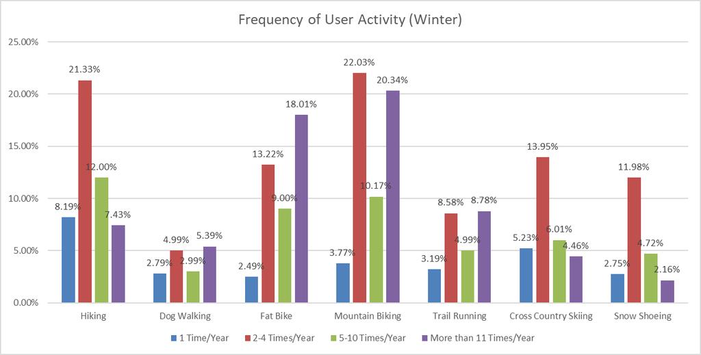
62
63
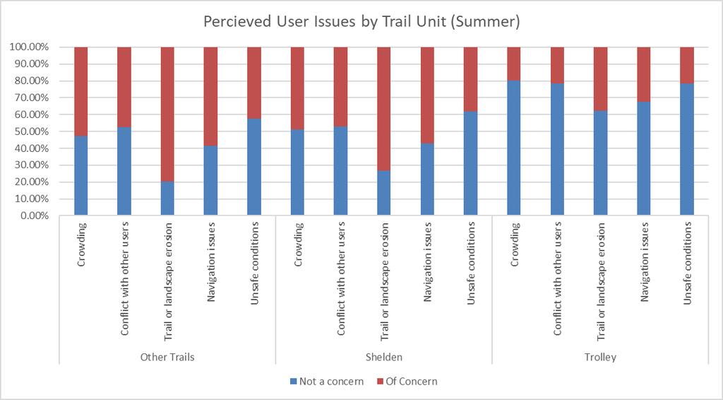
64 3. Respondent Issues

65 This chart is only those issue/units where more than half of respondents indicated there are issues of concern.
66 Pie Charts for Units/Issues that are of concern
67
68
69 4. Identified Opportunities
70
71
72 5. Important environmental impacts
73 APPENDIX E METAL-WOOD RIDING FEATURES
'*%\"+,!&-.#,!\"#$%&'(&)')*#+!")
74 APPENDIX E!"#$"%&&'(%) / !"#$"%&&'(%)'*%"+,!&-.#,!"#$%&'(&)')*#+!!!"#$%&$'(()*'+),'$-.#("/%.!
*7+.#/&&;'2<'!-\"#&)<,*+1#&,-$'7',5'85#$),0\"$'$8*50$0\"&*/1\"$.'00#&23?(&;-:>$2&+)= =#9'/-#$)#$5'-#&>9/0$*/&$-0##5$)#$'&#$ +9$#&\"'&+11&9'+*1&!<+.-(,&\"+9!/&&0:-!& :#$<!&)!&\"'&$'.")
\"&.'$'*!&.+(& 9#&.)!\"'2->#1&+!&+(&)<,*+1#/ B&)*%C;,/$<%&'*40%D=?+$@+((#+$&!\"##$&-!&.)\"&'(&')*&$+!#*&\"+9$#&\"'& #2-/&#$0\"#$'99/&'9<$*%$#7#&<$.,#9#$0\"'0$)#$ 2+()7+.\")*#/ 2&'(*%$#*)-)/&:/$<&)/*:*%)=!")
75 BIKE GRANBY RANCH MASTER PLAN APPENDIX E APPENDIX B!"#$%&%$'(%)*! #-7-:>$?,%@&;*= 0*)#&1-2#(!-'(&34564&#+!"#*(&*#1&.#1+*&-!&')*&!"+(1+*1& *-1-(,&!)*7+.#/&&8"&9'$"!&7*'2&)(1#*(#+":&#$-2-(+"-(,& 7+!"#(#*!&7*'2&":#&*-1-(,&!)*7+.#/&&;'2<'!-"#&)<,*+1#&,-$'7',5'85#$),0"$'$8*50$0"&*/1"$.'00#&23?(&;-:>$2&+)= =#9'/-#$)#$5'-#&>9/0$*/&$-0##5$)#$'&#$ +9$#&"'&+11&9'+*1&!<+.-(,&"+9!/&&0:-!& :#$<!&)!&"'&$'.+"#&":#&<*'<#*&!<+.-(,& +(1&-(!"+$$&*-1-(,&!)*7+.#&+..)*+"#$A&+(1& #?9,#205<3!047*%$A0&/= 455$-0##5$,-$.*)#$9*'0#6$0*$(':,(,;#$ 0"#$5,%#$*%$0"#$-0##53$$!"#$.*)6#&$9*'0$.'2#!&!"+(1+*1&-(&9$+.=%&9)"&.'$'*!&.+(& 9#&.)!"'2->#1&+!&+(&)<,*+1#/ B&)*%C;,/$<%&'*40%D=?+$@+((#+$&!"##$&-!&.)"&'(&')*&$+!#*&"+9$#&"'& #2-/&#$0"#$'99/&'9<$*%$#7#&<$.,#9#$0"'0$)#$ 2+()7+.")*#/ 2&'(*%$#*)-)/&:/$<&)/*:*%)=!"#$%&'(#)*&+$,-$./0$0*1#0"#&$),0"$0'(.#&$ &#-,-0'20$%'-0#2#&-3$$455$"'&6)'&#$,-$-0',25#--$!"##$%&"'&#(!)*#&+,+-(!"&.'**'!-'(/!!"#$%&'()$&%*$+,-./$/0$.&)/1$$ 23-)$-)$435$4*$(%06-7*$&$ 89$5*&%$.-'-/*7$4&%%&:/5$ 0:$0,%$(%07,;/)1$$! " # $ $ " % & % " % & ' %


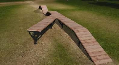
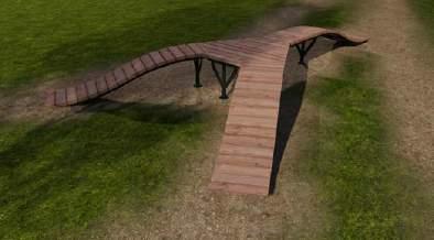
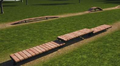
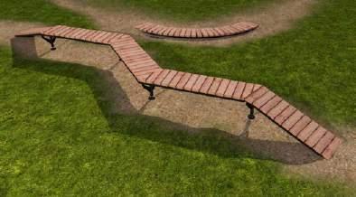
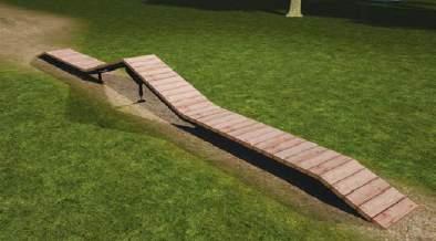
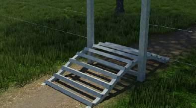
76 MASTER PLAN A PAPPENDIX P E N D I EX B!"#$%&'#((%)!*',1&(%2,!,+" *+(,-.&/+0.+-"1#,"&1+* (+-/'%&)+''%) 15%&678 3,4&3#4!!!"#$%&$'(()*'+),'$-.#("/%. 2#11'%&4-#)(&)+''%)!"


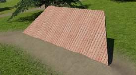
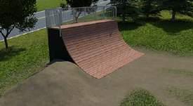
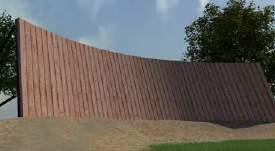
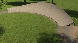
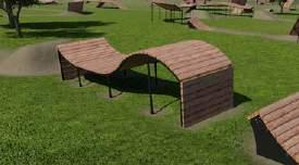
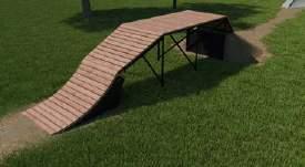
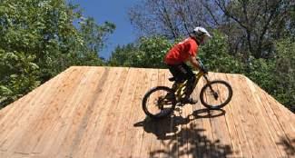
77 BIKE GRANBY RANCH MASTER PLAN APPENDIX E APPENDIX B!"#$%8$"#.,$!!"#$%&'"()#'*%"#'%+',-..'#%(/%'01'#(%2'3'2%4'"()#'*%5-(6% "%3"#-'(7%/4%8-9'#'.(%"-#%".8%:/5%/#-'.('8%;-$'%#"<1*%(/% ('"=6%#67(6<>%:/5>%".8%"-#%*$-22*?%%@6'*'%4'"()#'*%=".%;'% 8'*-,.'8%-.(/%"%8/5.6-22%/#%4#''#-8'%(#"-2>%;'%"88'8%(/%"% +AB%1"#$>%/#%6"3'%"%=)*(/<%8'*-,.'8%C)<1%1"#$%5-(6% "*%<".7%4'"()#'*%"*%7/)%5".(?%%!" *&+*$, 6$(7$'#"1%$ +.,:$('6"%% -./0'123 8%"#'6"%% #"%%"($7",2%%$, 9.",#$,'0&0$ 6)"%$'#"&% 4$!!5!"#$%%&#$'(&!)!#$0'.0;(264'123! " # $ $ " % & % " % & ' %

01'#4%'+;.+%0\"5' 8+/)<2+8='.%+3)/)#2'&-24>-304%+8'+?4).&+20'5#4%'7)*+' 3#&&42)05'$)\"\"'+2@#5'&-25'5+-%/'#>'31-\"\"+2<)2<'%)8)2<' 0+%%-)29'(+3-4/+'#4%'+?")
#2/'0#')20+<%-0+'>+-04%+/')20#' 5#4%'7)*+'.-%*'#%'0%-)\"'/5/0+&9':1+01+%'01%#4<1'8)%+30'.4%31-/+'-28')2/0-\"\"-0)#2'/4.+%B)/)#2'>%#&'#4%')2A1#4/+' +%(55'\"0'+1$!")
/'%+-85'0#'-//)/0' 5#4')2'/+\"+30)2<'01+'7+/0'%-&.'#.0)#2/'0#'%+-31'5#4%'7)*+'.-%*'<#-\"/9 BENEFITS OF FLOWFORM: PROJECT EXPERIENCE: D'89:;<=>?")


78 APPENDIX E ENHANCING PROGRESSION WE SUPPORT TRAIL BUILDERS BY PROVIDING DURABLE, ATHLETE INSPIRED PRODUCTS DESIGNED FOR ALL SKILL LEVELS AND ABILITIES. Whether through direct purchase and installation supervision from our in-house staff or specified in bids by expert trail designers and land- scape architects, integrating FlowForm into your project is easy and streamlined. WHY FLOWFORM?!"#$!#%&'()*+',-&./')/'01+'"#$'&-) '/#"40)#2' 0#'5#4%'3#&&42)056/'7)*+'.-%*'2++8/9':)01'#4%'+;.+%0"5' 8+/)<2+8='.%+3)/)#2'&-24>-304%+8'+?4).&+20'5#4%'7)*+' 3#&&42)05'$)""'+2@#5'&-25'5+-%/'#>'31-""+2<)2<'%)8)2<' 0+%%-)29'(+3-4/+'#4%'+?4).&+20')/'8+/)<2+8'0#'7+')20+%A!"##$!%$&'(#&'(&)*+%(,-$.'/"*0'1(02'!(#',$'0$!"#34*0$&' -28'+;.-28+8'-/'5#4%'7)*+'3#&&42)05'<%#$/9!"#$!#%&'#>>+%/'&-25'#.0)#2/'0#')20+<%-0+'>+-04%+/')20#' 5#4%'7)*+'.-%*'#%'0%-)"'/5/0+&9':1+01+%'01%#4<1'8)%+30'.4%31-/+'-28')2/0-""-0)#2'/4.+%B)/)#2'>%#&'#4%')2A1#4/+' +%(55'"0'+1$!63$&'6#',6&+',/'$71$0%'%0(6-'&$+64#$0+'(#&'-(#&A /3-.+'-%31)0+30/=')20+<%-0)2<'!"#$!#%&')20#'5#4%'.%#@+30')/' +-/5'-28'/0%+-&")2+89'C4%'+;.+%0'0+-&')/'%+-85'0#'-//)/0' 5#4')2'/+"+30)2<'01+'7+/0'%-&.'#.0)#2/'0#'%+-31'5#4%'7)*+'.-%*'<#-"/9 BENEFITS OF FLOWFORM: PROJECT EXPERIENCE: D'89:;<=>?'@ABC<D:C'E:F>'GD?F.'89:;<=>?.'EH D'89:;<=>?'I:==DJ>'GAHF><'GD?F.'89:;<=>?.'EH D'G?:CH>'J>A?J>'@:C:'E:F>'GD?F.'G?:CH>'J>A?J>.'EH D'KB>>C'H9D?=A<<>'E:F>'GD?F.'KB>>C'H9D?=A<<>.'EH D'H>H>=:D'?DI:C>'E:F>'GD?F.'I:H<A?:D.'EH D'H9>;<>?@>?>'E:F>'GD?F.'H9>;<>?@>?>.'DE D':CI>?JD??L'E:F>'GD?F.';B??>L.'EH D'<A=FDC'E:F>'GD?F.';9>=<>?'HAI>.'HD D'@HC>D?C>L'E:F>'GD?F.'GACM>?DL.':M D'ID=@AC<'E:F>'GD?F.'EAB=M>?.'HA D'?9LA=:<>'E:F>'GD?F.'HD;<=>'?AHF.'HA D'N>?C:>'HA@@BC:<L'GD?F.'N>?C:>.'EH D';>D'A<<>?'H=D;;:H.'@AC<>?>L.'HD REPLACEABLE RIDING SURFACE ADJUSTABLE & EXPANDABLE PRECISION MANUFACTURED EASY ASSEMBLY & INSTALLATION INFINITE DESIGN CONFIGURATIONS DURABLE (DESIGNED TO WITHSTAND 600LB RIDER LOAD) MULTIPLE PURCHASE OPTIONS AVAILABLE


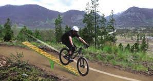
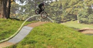
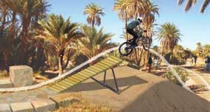

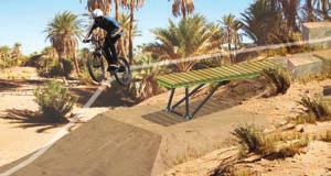
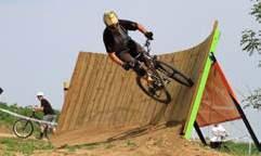

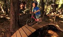
79 APPENDIX E 2014 RAMPS ROASTER DOUBLE BUBBLE LAUNCH PAD CANNON 30 CANNON FLAT RAINBOW SATELLITE ON/OFF ROCKER CURVED WALLRIDE FLAT WALLRIDE OVERPASS BRIDGE SHOREBRIDGE SUNSET TEETER TOTTER PRECAST LIP LOG RIDE KITS
APPENDIX D: SUSTAINABLE TRAIL DESIGN. APPENDICES Town of Chili Parks and Recreation Master Plan Update
 APPENDIX D: SUSTAINABLE TRAIL DESIGN APPENDICES Town of Chili Parks and Recreation Master Plan Update Sustainable Trail Construction Sustainable trails are defined by the US Forest Service as trails having
Understanding user expectations And planning for long term sustainability 1
 Understanding user expectations And planning for long term sustainability 1 What is a natural surface trail? It can be as simple has a mineral soil, mulched or graveled pathway, or as developed as elevated
2. STAKEHOLDER FEEDBACK // What We Heard
 1. QUARRY ROAD TRAIL // Welcome to the Information Session PROJECT DESCRIPTION WHY WE ARE HERE Quarry Road Trail is a popular commuter trail and recreational area for Calgarians. 1. To report citizen feedback
Mt. Hood National Forest
 United States Department of Agriculture Forest Service Mt. Hood National Forest Zigzag Ranger District 70220 E. Highway 26 Zigzag, OR 97049 503-622-3191 Fax: 503-622-5622 File Code: 1950-1 Date: June 29,
Trail Phasing Plan. Note: Trails in the Clear Creek Canyon area (Segments will be finalized in the future to minimize wildlife impacts
 Note: Trails in the Clear Creek Canyon area (Segments 2 5 and a future JCOS connection) will be finalized in the future to minimize wildlife impacts Trail Phasing Plan P Parking 3 Easy Trail Intermediate
ROAD AND TRAIL PROJECT APPROVAL
 ROAD AND TRAIL PROJECT APPROVAL www.marincountyparks.org Marin County Parks, 3501 Civic Center Dr, Suite 260, San Rafael, CA 94903 DATE: July 12, 2017 PRESERVE: Gary Giacomini Open Space Preserve PROJECT:
MORGAN CREEK GREENWAY Final Report APPENDICES
 APPENDICES MORGAN CREEK GREENWAY Appendix A Photos of Existing Conditions in Trail Corridor Photos of existing conditions Main trail corridor - February 2009 Photos of existing conditions south bank Morgan
DATE: 23 March, 2011 TO: Communities FROM: BlazeSports America. RE: Accessible Trails Checklist 1
 M E M O R A N D U M DATE: 23 March, 2011 TO: Communities FROM: BlazeSports America RE: Accessible Trails Checklist 1 The purpose of the Accessible Trails Checklist (below) is to help the community review
Table of Contents. page 3 Long term Goals Project Scope Project History. 4 User Groups Defined Trail Representative Committee. 5 Trail Users Breakdown
 Launched April 27th, 2010 1 Table of Contents page 3 Long term Goals Project Scope Project History 4 User Groups Defined Trail Representative Committee 5 Trail Users Breakdown 13 Trail Users Desires 16
TRAIL MAINTENANCE AND CONSTRUCTION MANUAL
 TRAIL MAINTENANCE AND CONSTRUCTION MANUAL MAINTAINING THE TRAIL CORRIDOR GENERAL MAINTENANCE Debris and Obstacles Remove dangerous obstacles that riders may fall on - logs and branches one-half inch in
Appendix A Appendix A (Project Specifications) Auk Auk / Black Diamond (Trail 44) Reroute
 Auk Auk / Black Diamond (Trail 44) Reroute") Appendix A (Project Specifications) Auk Auk / Black Diamond (Trail 44) Reroute I. Proposed Action: This project proposes to reroute approximately 1,800 feet of a 50 inch wide trail, off of private property
Appendix A (Project Specifications) Auk Auk / Black Diamond (Trail 44) Reroute I. Proposed Action: This project proposes to reroute approximately 1,800 feet of a 50 inch wide trail, off of private property
INTRODUCTION. Mailing address: Burke County Community Development Attn: Tim Johnson P. O. Box 219 Morganton, NC
 REQUEST FOR QUALIFICATIONS: PROFESSIONAL, EXPERIENCED TRAIL BUILDERS FOR THE CONSTRUCTION OF THE FONTA FLORA STATE TRAIL LAKE JAMES SECTION BURKE COUNTY COMMUNITY DEVELOPMENT INTRODUCTION Burke County
Bear Creek Habitat Improvement Project
 06/10/10 Bear Creek Habitat Improvement Project El Paso County, Colorado Pike National Forest and Colorado Springs Utilities Owned Land Report prepared by: Eric Billmeyer Executive Director Rocky Mountain
GATEWAY PHASE 2. U.S. Forest Service and the Mount Shasta Trails Association
 GATEWAY PHASE 2 U.S. Forest Service and the Mount Shasta Trails Association PROJECT DEVELOPMENT Brief history - Gateway Phase 1 - IMBA conceptual plan - BikeShasta: concert series - USFS & MSTA partnered
Preferred Recreation Recommendations Stemilt-Squilchuck Recreation Plan March 2018
 Preferred Recreation Recommendations Stemilt-Squilchuck Recreation Plan March 2018 Below are the recommended recreation ideas and strategies that package together the various recreation concepts compiled
The Whitefish Trail
 The Trail - 2017 Trail Construction Specifications & Scope of Services The Lower Haskill section of Trail construction will take place on two different land ownerships: City of and Iron Horse. This section
Evergreen Trail School
 Evergreen Trail School Making Washington a Better Place to Ride Preston, WA & Tiger Mt. Sat, April 9, 2015 8-11:45am: Classroom 11:45-12:45pm: Lunch 12:45-4pm: Trail Work Classroom Agenda Introduction
City of Durango 5.8 FUNDING TRAILS DEVELOPMENT
 5.8 FUNDING TRAILS DEVELOPMENT The City has been successful in establishing dedicated local funding sources as well as applying for grants to develop the City s trail system, having received nearly $2.4
Non-motorized Trail Plan & Proposal. August 8, 2014
 Town of Star Valley Ranch, Wyoming and the Star Valley Ranch Association in partnership with the USDA Forest Service, Bridger-Teton National Forest, Greys River Ranger District Non-motorized Trail Plan
Proposed Peninsula Bay Bike Track Development
 Proposed Peninsula Bay Bike Track Development May 2018 BACKGROUND The area of land at the northern extreme of Wanaka's Peninsula Bay development (Lot 923 DP 501325), currently owned by Infinity Investment
SEGMENT ASSESSMENT REPORT
 2017 SEGMENT ASSESSMENT REPORT SEGMENT 3: MT ROSE / TAHOE MEADOWS TO SPOONER SUMMIT REPORT SUMMARY This report is a compilation of information collected on the Tahoe Rim Trail during assessments performed
Stony Creek Master Plan Public Meeting #2. May 21, 2016
 Stony Creek Master Plan Public Meeting #2 May 21, 2016 Today s Agenda 10:00 10:20 am Presentation 10:20 10:45 am Q & A 10:45 11:30 am Browse, discuss, and comment Metroparks Master Plan Process 4 months
Logo Department Name Agency Organization Organization Address Information 5700 North Sabino Canyon Road
 Logo Department Name Agency Organization Organization Address Information United States Forest Coronado National Forest 5700 North Sabino Canyon Road Department of Service Santa Catalina Ranger District
Thank you for the opportunity to comment on the proposed action to add trails and trailheads to the Red Rock District trail system.
 July 14, 2010 Jennifer Burns Red Rock Ranger District PO Box 20429 Sedona, AZ 86341 Flagstaff Biking Organization PO Box 23851 Flagstaff, AZ 86002 Dear Jennifer- Thank you for the opportunity to comment
Trail Master Plan. Hungry Mother State Park
 Trail Master Plan For Hungry Mother State Park Prepared for Virginia State Parks Presented by Trail Dynamics, LLC PO Box 664 Cedar Mountain, NC 28719 www.traildynamics.com 1 1 Table of Contents Introduction
Theme: Predominately natural/natural appearing; rustic improvements to protect resources. Size*: 2,500 + acres Infrastructure**:
 Recreation Opportunity Spectrum (ROS) Classes The Recreation Opportunity Spectrum (ROS) provides a way to describe the variations in the degree of isolation from the sounds and influences of people, and
Port Gamble Shoreline Area Conceptual Trail Proposal
 The North Kitsap Trails Association is pleased to be a partner to the Kitsap Forest and Bay Project and assist Kitsap County, Forterra, Olympic Property Group, Great Peninsula Conservancy and the Port
Kit Carson-Challenger Ridge Trail Project
 Kit Carson-Challenger Ridge Trail Project Project Accomplishments Report-USFS December 15, 2015 Photo courtesy of Justin Peterson 815 South 25 th Street, Suite 101 Colorado Springs, CO 80904 Dedicated
MASTER PLAN EXECUTIVE SUMMARY
 Biscuit Run State Park Scottsville Road (State Route 20) Charlottesville, VA 22902 Biscuit Run State Park MASTER PLAN EXECUTIVE SUMMARY Department of Conservation and Recreation Division of Planning and
Subj: POLICY FOR MAINSIDE TRAIL USE AT MARINE CORPS BASE QUANTICO
 UNITED STATES MARINE CORPS MARINE CORPS BASE QUANTICO, VIRGINIA 22134-5001 MCBO 5090.4 B 04 MARINE CORPS BASE ORDER 5090.4 From: Commander To: Distribution List Subj: POLICY FOR MAINSIDE TRAIL USE AT MARINE
2. Goals and Policies. The following are the adopted Parks and Trails Goals for Stillwater Township:
 D. PARKS AND TRAILS 1. Introduction Stillwater Township s population is relatively low, with most residents living on rural residences on large lots. The need for active park space has been minimal in
Tracy Ridge Shared Use Trails and Plan Amendment Project
 Tracy Ridge Shared Use Trails and Plan Amendment Project Scoping Document Forest Service Allegheny National Forest Bradford Ranger District McKean, County, Pennsylvania In accordance with Federal civil
General Issues with the Portland Parks & Recreation Trail Design Guidelines for Portland s Park System ( Portland Guidelines )
") Why the City of Portland s current Trail Design Guidelines (2009) are substandard & need to be updated. For purposes of this discussion we will be referring to the following natural surface trail guidelines:
Why the City of Portland s current Trail Design Guidelines (2009) are substandard & need to be updated. For purposes of this discussion we will be referring to the following natural surface trail guidelines:
Walking Track Classification System Parks and Wildlife Service
 Appendix A Walking Track Classification Specifications Walking Track Classification System Parks and Wildlife Service This Walking Track Classification System is the outcome of a review of the track classifications
Trails Classification Steering Team Alberta Tourism, Parks and Recreation Alberta Sustainable Resource Development Alberta TrailNet Society
 Acknowledgements Alberta Recreation Corridor and Trails Designation Program Alberta Recreation Corridors Coordinating Committee Trails Classification Steering Team Alberta Tourism, Parks and Recreation
Project Planning, Compliance, and Funding
 Project Planning, Compliance, and Funding The plans above offer high level guidance to ensure that the A.T. is managed effectively as a whole unit in a decentralized management structure. Cooperative management
Snowmobile GUIDELINES FOR TRAIL SIGNING
 STATE OF NEW HAMPSHIRE BUREAU OF TRAILS Snowmobile GUIDELINES FOR TRAIL SIGNING TRAIL FUNDED BY REGISTRATION FEES Table of Contents Introduction... Some Things to Take Into Consideration... BOT Provided
Appendix 3. Greenway Design Standards. The Whitemarsh Township Greenway Plan
 Appendix 3 Greenway Design Standards This chapter discusses two design standards for the greenway types discussed above. First, trail design standards are presented together with trailhead facilities and
Great Pond Mountain Conservation Trust Request for Bids Wildlands Hillside Trail Relocation and Restoration Project
 Great Pond Mountain Conservation Trust Request for Bids Wildlands Hillside Trail Relocation and Restoration Project Project Description: Great Pond Mountain Conservation Trust (GPMCT), a nonprofit land
Minnesota Off-Road Cyclists
 Minnesota Off-Road Cyclists MORC Mission Minnesota Off-Road Cyclists is a nonprofit volunteer organization dedicated to safeguarding the future of mountain biking in Minnesota through the promotion of
Kennesaw Mountain Trail Club. Trail Skills Workshop ~ Dips and Drains. Presented by: Jay M Dement
 Kennesaw Mountain Trail Club Trail Skills Workshop ~ Dips and Drains Presented by: Jay M Dement KEY CONCEPTS: Control Erosion and Users Where Do Trails Come From, and How Do They Work: Concept of trail
Stephens State Park Trails
 TRAILS OF ALLAMUCHY MOUNTAIN & STEPHENS STATE PARKS Allamuchy Mountain and Stephens State Parks contain 28 marked trails providing access to diverse landscapes for walking, hiking, biking, bird-watching,
Course 102. Tread and Drainage
 PCTA Trail Skills College Curriculum Instructor Planning Guide Water and gravity constantly threaten our trails and thus we must learn how best to deflect them. This course begins with basics of hillside
Proposed Action. Payette National Forest Over-Snow Grooming in Valley, Adams and Idaho Counties. United States Department of Agriculture
 United States Department of Agriculture Forest Service January 2012 Proposed Action Payette National Forest Over-Snow Grooming in Valley, Adams and Idaho Counties Payette National Forest Valley, Adams
American Conservation Experience
 ACE Project Report For Tonto National Forest, Arizona Trail Association and Arizona State Parks Title of Project: 4 Peaks Trail Maintenance Award Contract Number: ASP NM11021 Project Partner: Paul Burghard
Rule Governing the Designation and Establishment of All-Terrain Vehicle Use Trails on State Land
 Rule Governing the Designation and Establishment of All-Terrain Vehicle Use Trails on State Land 1.0 Authority 1.1 This rule is promulgated pursuant to 23 V.S.A. 3506. Section 3506 (b)(4) states that an
Form for Project Descriptions - December 2013 version! 1. Stone Valley Cooperative Recreation Area (SVCRA) Project Description
 Project Description") Form for Project Descriptions - December 2013 version 1 Stone Valley Cooperative Recreation Area (SVCRA) Project Description The Stone Valley partners request that proposed work on land within the SVCRA
Form for Project Descriptions - December 2013 version 1 Stone Valley Cooperative Recreation Area (SVCRA) Project Description The Stone Valley partners request that proposed work on land within the SVCRA
Appendix C. Tenderfoot Mountain Trail System. Road and Trail Rehabilitation Plan
 Appendix C Tenderfoot Mountain Trail System Road and Trail Rehabilitation Plan All rehabilitation work would be under the direction of the District Fisheries Biologist, the Forest Hydrologist, and/or the
Chapter 6: POLICY AND PROCEDURE RECOMMENDATIONS
 Chapter 6 POLICY AND PROCEDURE RECOMMENDATIONS FOR SRRA Below are seven policy elements that should be considered for adoption by the Southwest Regional Recreation Authority of Virginia: 1. Develop strategies
BACKCOUNTRY TRAIL FLOOD REHABILITATION PROGRAM
 BACKCOUNTRY TRAIL FLOOD REHABILITATION PROGRAM Backcountry Trail Flood Rehabilitation A June 2013 Flood Recovery Program Summary In June 2013, parts of Southern Alberta were devastated from significant
WASHINGTON STATE PARKS AND RECREATION COMMISSION POLICY/PROCEDURE
 WASHINGTON STATE PARKS AND RECREATION COMMISSION POLICY/PROCEDURE 65-13-1 Use of Other Power-Driven Mobility Devices by Persons with Mobility Disabilities at State Park Facilities See Also: 28 CFR 35 Title
Bear Creek Watershed Restoration Project Final Project Report December 21, 2016
 Bear Creek Watershed Restoration Project Final Project Report December 21, 2016 Dedicated to the conservation and stewardship of public lands in Southern Colorado Rocky Mountain Field Institute 815 South
EXECUTIVE SUMMARY PROGRAM DEVELOPMENT REPORT PURPOSE EXISTING SETTING EXPANDING PARKLAND
 EXECUTIVE SUMMARY PROGRAM DEVELOPMENT REPORT PURPOSE As the culmination of the first phase of the master planning process, this Program Development Report creates the framework to develop the Calero County
Trails Technical Committee
 Trails Technical Committee Winter 2017 Draft Report Alignment Proposals for the Inyo National Forest and the Town of Mammoth Lakes Map ID #S18 February 08, 2017 Map ID #S18 Key Agreements As of February
National Forests and Grasslands in Texas
 United States Department of Agriculture Forest Service National Forests and Grasslands in Texas Sam Houston NF 394 FM 1375 West New Waverly, Texas 77358 Phone 936-344-6205 Dear Friends, File Code: 1950
Thank you for this second opportunity to comment on the proposed revisions to the Coconino National Forest Management plan.
 March 8, 2011 Flagstaff Biking Organization PO Box 23851 Flagstaff, AZ 86002 Yewah Lau Coconino National Forest Attn: Plan Revision 1824 South Thompson Street Flagstaff, Arizona 86001 Sent via electronic
Trail Assessment Report
 Trail Assessment Report Trail Options for the Bear Creek Canyon located in Pikes Peak Ranger District, Pike National Forest and on Colorado Springs Utility Lands Due to the presence of a unique species
Specification for Grip blocking using Peat Dams
 Technical Guidance Note 1 Specification for Grip blocking using Peat Dams 1. Introduction Moorland drains (grips) have been dug across much of the Yorkshire upland peatlands. Many of these grips have become
Proposal to Redevelop Lower Kananaskis River-Barrier Lake. Bow Valley Provincial Park
 Frequently Asked Questions Proposal to Redevelop Lower Kananaskis River-Barrier Lake Bow Valley Provincial Park Frequently Asked Questions What has been decided? What are the details of the plan? What
TRUCKEE TAHOE AIRPORT DISTRICT BOARD OF DIRECTOR STAFF REPORT
 AGENDA ITEM: 11 TRUCKEE TAHOE AIRPORT DISTRICT BOARD OF DIRECTOR STAFF REPORT AGENDA TITLE: MEETING DATE: January 24, 2018 PREPARED BY: NTPUD Agency Partnership Opportunity, Multi-Use Trailhead Access
Section II. Planning & Public Process Planning for the Baker/Carver Regional Trail began in 2010 as a City of Minnetrista initiative.
 Section II Planning & Public Process Planning for the began in 2010 as a City of initiative. city staff began discussions with the Park District on the possibility of a north/south regional trail connection
FEASIBILITY CRITERIA
 This chapter describes the methodology and criteria used to evaluate the feasibility of developing trails throughout the study areas. Land availability, habitat sensitivity, roadway crossings and on-street
Longmont to Boulder Regional Trail Jay Road Connection DRAFT FINAL REPORT
 Longmont to Boulder Regional Trail Jay Road Connection DRAFT FINAL REPORT December 2018 Project Summary Boulder County, Colorado, in partnership with the City of Boulder, is evaluating options for multi-use
NEWBORO AND PORTLAND HARBOUR REDVELOPMENT PLANS
 INTRODUCTION The Municipal docks in both Newboro and Portland were transferred to the Township of Rideau Lakes by Parks Canada in 2002. Little has been done to improve the docks physical condition or role
Proposal to Redevelop Lower Kananaskis River-Barrier Lake. Bow Valley Provincial Park. Frequently Asked Questions
 Proposal to Redevelop Lower Kananaskis River-Barrier Lake Bow Valley Provincial Park Frequently Asked Questions What is being proposed? What are the details of the proposal? Where is the project area located?
Permeable RECREATIONAL TRAILS
 SMART EARTH SOLUTIONS Permeable RECREATIONAL TRAILS GEOWEB GEOPAVE GEOTERRA Innovative Solutions for Designing & Building Trails. Trail Surface Stabilization The key to planning and building trails into
Guidelines for Snowmobile Trail Signing and Placement STOP SLOW
 Guidelines for Snowmobile Trail Signing and Placement STOP SLOW Table of Contents 1.0 Introduction... 2 6.0 Examples of Sign Use...7 2.0 Purpose of this Document... 2 3.0 Trail Signing Guidelines... 2
Procedure for the Use of Power-Driven Mobility Devices on Mass Audubon Sanctuaries 1 September 17, 2012
 Procedure for the Use of Power-Driven Mobility Devices on Mass Audubon Sanctuaries 1 September 17, 2012 Background As part of Mass Audubon s mission to preserve the nature of Massachusetts for people and
Recreation News. Welcome. Chris Jackson. In this Issue: O S U C o l l e ge F o r e s t s
 Recreation News O S U C o l l e ge F o r e s t s In this Issue: Welcome New tree identification posts... New Arboretum Trails New Interpretive Signs Ridge Trail Seasonal Closures Leave No Trace reminder
New Mountain Bike Trails Proposal. Wharncliffe Woods- Sheffield
 New Mountain Bike Trails Proposal. Wharncliffe Woods- Sheffield Overview We propose to create two new cross country trail within Wharncliffe woods, one to replace the existing black trail, which has become
United States Department of the Interior National Park Service. Boundary Expansion Listed in National Register January 11, 2017
 NPS Form 10900-a (Rev. 8/2002) OMB No. 10240018 United States Department of the Interior National Park Service Boundary Expansion Listed in National Register January 11, 2017 National Register of Historic
April 19-21, See below for Course Descriptions. Columbia Cascades Trail Skills College Cascades Locks, Oregon.
 Columbia Cascades Trail Skills College Cascades Locks, Oregon April 19-21, 2013 Friday, April 19 198, 199 First Aid and CPR 300 Basic Rock Work 302 Water Crossings and Seeps 398 Working with Pack Stock
PROPOSED ACTION South 3000 East Salt Lake City, UT United States Department of Agriculture
 United States Department of Agriculture Forest Service Uinta-Wasatch-Cache National Forest Salt Lake Ranger District 6944 South 3000 East Salt Lake City, UT 84121 801-733-2660 File Code: 1950/2300 Date:
LANDER AREA MASTER TRAILS PLAN. Lander Cycling Club November 2012
 LANDER AREA MASTER TRAILS PLAN Lander Cycling Club November 2012 Table of Contents A. Overview 3 B. Introduction 4 C. Visitor Profile 5 D. Benefits to the Community 6 E. Area wide Goals and Objectives
Cultural Resource Management Report Deer Valley 4wd Restoration and Blue Lakes Road Maintenance Project R
 Cultural Resource Management Report R2015-05-03-10005 Undertaking Description: The proposes to perform road maintenance and meadow restoration on the Deer Valley 4wd trail and road maintenance on the Blue
Thank you for the opportunity to comment on the Mount Elden/Dry Lake Hills Recreation Planning Proposed Action, (MEDL).
.") November 27, 2014 Brian Poturalski Recreation and Wilderness Staff Officer Flagstaff Ranger District Coconino National Forest 5075 N. Highway 89 Flagstaff, AZ 86004 comments-southwestern-coconino-flagstaff@fs.fed.us
November 27, 2014 Brian Poturalski Recreation and Wilderness Staff Officer Flagstaff Ranger District Coconino National Forest 5075 N. Highway 89 Flagstaff, AZ 86004 comments-southwestern-coconino-flagstaff@fs.fed.us
Snowmobile Trail Signing REF: DNR Trail Signing Handbook
 AWSC FALL WORKSHOP TRAIL SIGNING & MAINTENANCE NOVEMBER 5, 2011 Workshop presenters: Larry Erickson, AWSC Trails Committee Chairman, Iron County Director Dave Peterson, Langlade County Director Snowmobile
RE: Access Fund Comments on Yosemite National Park Wilderness Stewardship Plan, Preliminary Ideas and Concepts
 September 30, 2016 Superintendent Yosemite National Park Attn: Wilderness Stewardship Plan P.O. Box 577 Yosemite, CA 95389 RE: Access Fund Comments on Yosemite National Park Wilderness Stewardship Plan,
Understanding the caring capacity of the visitor experience Provide facilities to support a high level user experience Address visual quality through
 Understanding the caring capacity of the visitor experience Provide facilities to support a high level user experience Address visual quality through recreation ecological restoration opportunities Collaboration
CRAZY HORSE TRAIL GUIDE
 CRAZY HORSE TRAIL GUIDE Abridged Version: July 2016 This is a short form of our interpretive trail guide for the Crazy Horse Trail. The full version of the guide has a more detailed description of the
Thank you for this third opportunity to comment on the proposed revisions to the Coconino National Forest Management plan.
 March 19, 2014 Flagstaff Biking Organization PO Box 23851 Flagstaff, AZ 86002 Vern Keller Coconino National Forest Attn: Plan Revision 1824 South Thompson Street Flagstaff, Arizona 86001 coconino_national_forest_plan_revision_team@fs.fed.us
Bibbulmun Track. Cape to Cape Track. Two of the world s great long distance walking tracks. 973 km. 135 km km Off-road cycle touring
 Trail revitalising Western Australia Bibbulmun Track 973 km Cape to Cape Track 135 km Two of the world s great long distance walking tracks 1062 km Off-road cycle touring Trail revitalising 1. Framework
Assessing Your Trails, Keeping Them Safe and Enjoyable
 Jon Wood, PLA, ASLA Associate Vice President Stewart Bert Lynn, PLA, ASLA, LEED AP Project Manager Mecklenburg County Asset and Facility Management Assessing Your Trails, Keeping Them Safe and Enjoyable
Group similar facilities together separate dissimilar facilities.
 Park design Principle #1 Group similar facilities together separate dissimilar facilities. Why do we do this? Safety Differences in admission fees Differences in seasonal use Reduce user conflicts Principle
TOWN OF MAMMOTH LAKES Soft-Surface Trails Concept
 TOWN OF MAMMOTH LAKES Soft-Surface Trails Concept Presented by Trail Solutions July 2008 1 1. INTRODUCTION A. Document Purpose.The Town of Mammoth Lakes (TOML or Town), and its planning partners, recognized
APPENDIX B LAND MANAGER SURVEY
 APPENDIX B LAND MANAGER SURVEY #1 COMPLETE Collector: Web Link 1 (Web Link) Started: Tuesday, March 20, 2018 11:39:32 AM Last Modified: Tuesday, March 20, 2018 12:05:50 PM Time Spent: 00:26:18 IP Address:
Lake Windermere Westside Legacy Trail. A multi-use non-motorized paved trail promoting health, wealth and outdoor appreciation
 Lake Windermere Westside Legacy Trail A multi-use non-motorized paved trail promoting health, wealth and outdoor appreciation Jan 26, 2015 Executive Summary The Lake Windermere Westside Legacy Trail will
National Recreation Trail Update Form
 National Recreation Trail Update Form Introduction Thank you for taking the time to complete this form. Your assistance will help ensure that the National Recreation Trail (NRT) database is complete and
National Recreation Trail Application for Designation
 National Recreation Trail Application for Designation Introduction Thank you for your interest in the National Recreation Trail (NRT) program. Completed NRT application packages must be submitted by December
THRESHOLD GUIDELINES FOR AVALANCHE SAFETY MEASURES
 BRITISH COLUMBIA MINISTRY OF TRANSPORTATION & INFRASTRUCTURE AVALANCHE & WEATHER PROGRAMS THRESHOLD GUIDELINES FOR AVALANCHE SAFETY MEASURES British Columbia Ministry of Transportation & Infrastructure
Arrowhead Park Flow Trail Construction 16 April 2018 SPECIFICATIONS AND SCOPE OF WORK ARROWHEAD PARK FLOW TRAIL CONSTRUCTION
 SPECIFICATIONS AND SCOPE OF WORK ARROWHEAD PARK FLOW TRAIL CONSTRUCTION Section 1: Project Description and Scope 1.1 General Project Description and Scope 1.2 Mountain Bike Specific Flow Trail 1.3 Signage
WELCOME to the Iditarod Dog Sledding Historic District (IDSHD) Workshop. January 11, Houston Middle School Houston, Alaska
 Workshop. January 11, Houston Middle School Houston, Alaska") WELCOME to the Iditarod Dog Sledding Historic District (IDSHD) Workshop January 11, 2012 Houston Middle School Houston, Alaska Workshop Purpose: Present/discuss proposed resolutions to comments received
WELCOME to the Iditarod Dog Sledding Historic District (IDSHD) Workshop January 11, 2012 Houston Middle School Houston, Alaska Workshop Purpose: Present/discuss proposed resolutions to comments received
MPRB: Southwest LRT Community Advisory Committee Issues and Outcomes by Location Current to: 12 November 2010
 MPRB: Southwest LRT Community Advisory Committee Issues and Outcomes by Location Current to: 12 November 2010 This is a compilation of issues and outcomes identified by the CAC. It is a work in progress,
A Publication of Friends of Sleeping Bear Dunes
 A Publication of Friends of Sleeping Bear Dunes 2014, Friends of Sleeping Bear Dunes, P.O. Box 545, Empire, MI 49630 www.friendsofsleepingbear.org info@friendsofsleepingbear.org Learn more about the Friends
Peter Axelson. Beneficial Designs, Inc. Minden, NV
 Peter Axelson Beneficial Designs, Inc. Minden, NV Arroya Sit Ski Mono Ski Dynamic Seating Spring Assist Cross Country Ski Hand Bike Adaptive Canoe Seating Available from Chosen Valley Canoe Accessories
Chorley Park Trail Connection New Design Options. Information Booklet Prepared for June 9, 2014 Public Meeting
 Chorley Park Trail Connection New Design Options Information Booklet Prepared for June 9, 2014 Public Meeting Chorley Park Trail Booklet June 9, 2014 Page 1 of 12 Our Goals for the Chorley Park Trail Connection
EAST DON TRAIL ENVIRONMENTAL ASSESSMENT. Community Liaison Committee Meeting #3 July 15, :30 to 8:30 pm Flemingdon Park Library
 EAST DON TRAIL ENVIRONMENTAL ASSESSMENT Community Liaison Committee Meeting #3 July 15, 2013 6:30 to 8:30 pm Flemingdon Park Library Agenda 1. Welcome 2. Housekeeping and Updates a) Housekeeping b) CLC
Discussion Paper: Development of a Plan for Trails on Public Land
 Discussion Paper: Development of a Plan for Trails on Public Land APRIL 2017 The purpose of this Discussion Paper is to summarize the status & issues relating to District trails and feedback to date, and
Yard Creek Provincial Park. Management Plan
 Yard Creek Provincial Park Management Plan Draft January 2010 Yard Creek Provincial Park Management Plan Approved by: telàlsemkin/siyam/chief Scott Benton Bill Williams Squamish Executive Director ation
3. COLTA / HUGA CONNECTIONS - PRELIMINARY
 9 3. COLTA / HUGA CONNECTIONS - PRELIMINARY 3.1 COLTA The Chain of Lakes Trail Association (COLTA) trail, formerly identified as the Chester Spur Line, was completed and opened for use in June 2011. The