Thank you for the opportunity to comment on the Mount Elden/Dry Lake Hills Recreation Planning Proposed Action, (MEDL).
|
|
|
- Rosamund Casey
- 5 years ago
- Views:
Transcription

1 November 27, 2014 Brian Poturalski Recreation and Wilderness Staff Officer Flagstaff Ranger District Coconino National Forest 5075 N. Highway 89 Flagstaff, AZ Sent via electronic mail Flagstaff Biking Organization PO Box Flagstaff, AZ Dear Brian- Thank you for the opportunity to comment on the Mount Elden/Dry Lake Hills Recreation Planning Proposed Action, (MEDL). Background Flagstaff Biking Organization (FBO) is a group of cyclists who came together to promote bicycling as a safe and attractive means of transportation and recreation in Northern Arizona. Our initial project was to put on a Bike to Work Week for our community in May Building on the success we started to expand our efforts to keep people informed of cycling related issues and galvanize support for better and safer facilities, trails, and trail access. We have a successful and ongoing 10+ year relationship with the Coconino National Forest, Coconino County and the City of Flagstaff, including a Memorandum of Understanding to work cooperatively to provide for non-motorized trails opportunities in the Flagstaff area. Please see for more information on our organization. We strongly support the purpose and need for this Proposed Action, (PA), to respond to resource impacts from increasing and changing demands for trail use and other nonmotorized dispersed recreation on National Forest System lands, to provide managed parking and trails that are sustainable, and to improve the safety of visitors within MEDL area. We appreciate that we were involved in the preliminary scoping and that much of our early input was incorporated into the PA.
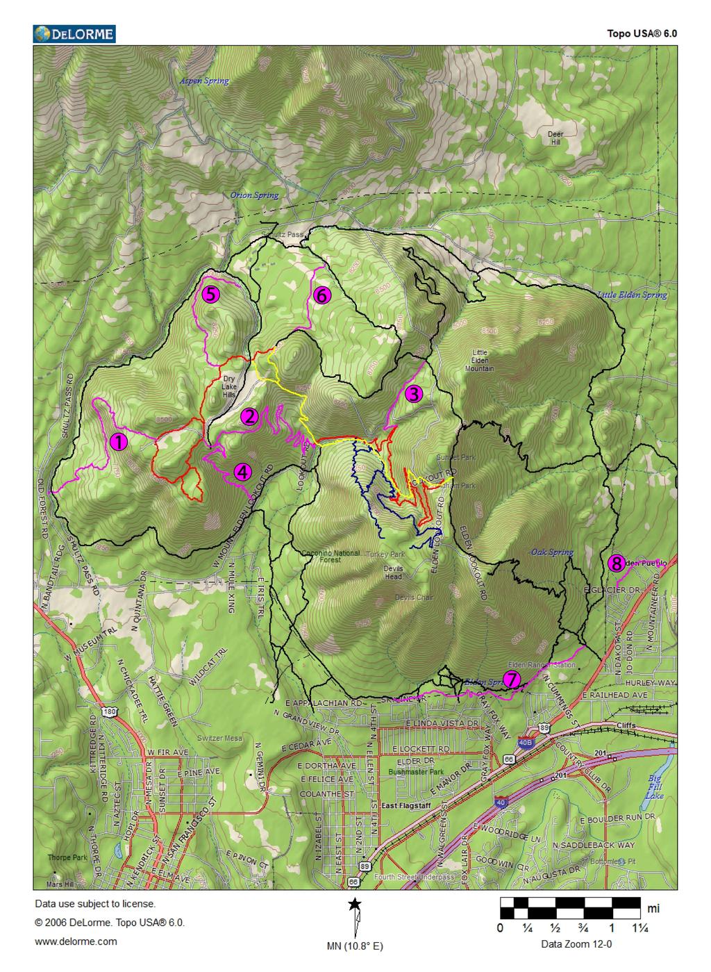
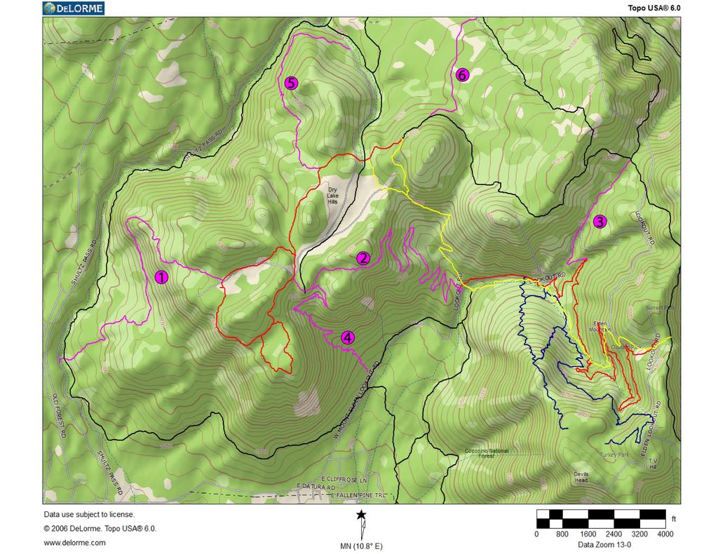
2 The best management strategies are those that address the needs of the recreating public in a manner that is both environmentally and socially sustainable. In fact environmental sustainability cannot be achieved in recreation management without social sustainability. In order to achieve social sustainability, it is important to recognize the quantitative and qualitative needs of the various user groups. It is relatively easy to measure quantitative needs, as surveys can readily assess how many people participated in a given activity within a time frame. Qualitative needs are far more difficult to measure and address but potentially more important. Please recognize that this project s success is extremely dependent upon the details inherent in recognizing and providing for an exceptionally diverse array of recreational needs, and that the details of those needs are difficult to express. It is important to recognize the substantial number of user-created and historic trails and routes that are part of the existing condition, and what these trails represent. (Most of these routes are shown in the maps accompanying the PA.) We understand that the any action the District takes will result in a net reduction in route mileage. We want to be sure that the District recognizes that this is a quantitative net loss in recreational opportunities as well as a substantial and quantitative reduction in environmental impact. Our hope is that this loss in quantity will be accompanied by a substantial qualitative improvement that will encourage users to eschew using and constructing unauthorized routes, leading to continued minimization of environmental impact as a result of the implementation of this planning. Please carefully consider our input on the specifics of the MEDL Recreation PA. We have formally and informally surveyed hundreds of cyclists and attempted to distill this into concepts that will address this diverse user group s needs while addressing more universal concerns such as user conflicts, erosion, wildlife and sustainability. Comments on the components of the Proposed Action New Trail Construction We strongly support the District citing the use of the Forest Service Trails Handbook Best Management Practices. We also strongly recommend that District seek the input of professionals such as IMBA Trail Solutions and Gravity Logic and trail users especially when implementing some of the more technically challenging downhill and all-mountain style trails. Consulting with professionals particularly on more specific aspects such as trail flow and the incorporation of challenging features will assure that these trails best address the qualitative needs of these riders. Where the District is choosing to convert road to single-track trail, in particular in coordination with the Flagstaff Watershed Protection Project, (FWPP), please bear in mind the fact that only closing one side of a two-track does not yield single-track trail. Better management strategies incorporate deviating trail tread from the road within
3 corridor, moving large objects such as boulders into the obliterated roadbed, ripping and re-seeding. Please coordinate with the road construction personnel in advance of the construction of new roads as part of the FWPP to implement strategies that will lead to the best trails as part of the MEDL implementation later. For example, if imported materials are to be used in the roadbed, consider using the City of Flagstaff s FUTS Mix rather than other looser gravels where the road will be converted to Flagstaff Loop Trail class 4 trail. We would like to be closely involved in the specific corridor layouts of most of these new trails. Equestrian Trail System We support the need for this system. It is our understanding from conversations with our friends in the horseback riding community that opportunities for riding that minimize interaction with cyclists are better than riding on trails with lots of cyclists. Although we do not support this system being closed to bicycles, we feel that the location of these trails will organically lend itself to low levels of bicycle use. Its proximity to the Elden Springs Horse Camp and away from the multi-use Flagstaff Urban Trail System and other multi-use trailheads is ideal for these users. We also see this trail system as directly beneficial to cyclists seeking more remote opportunities for exploration of the mountain. (This does not imply that these trails would attract a substantial number of cyclists in any way, as this is a relatively small number of riders.) Downhill Mountain Biking These trails are long over due! We first approached the District nearly a decade ago with a proposal to adopt these trails onto the Forest Service system. This a growing aspect of mountain biking and it appeals to young riders. As we have commented in the past, implementation of these trails directly assists the Forest Service in its More Kids in the Woods program, and perhaps some of the funding for the implementation of these trails could come from this program. There is strong demand for this opportunity amongst adults and a tightly knit community of trail users ready to help construct and maintain these trails. We strongly recommend that the District rely upon these riders, as well as the professionals we mentioned above, when laying out, constructing and building these routes. The riders involved in this aspect of the sport are extremely preferential to the types of features and flow of the trails. Providing ample opportunities for this use that are separate from the rest of the multi-use system will greatly alleviate user conflict concerns as these riders will be able to ride nearer their limits without potentially startling or colliding with other users. Please consider adding some additional routes within the general area proposed for downhill mountain bike trails. Additionally, and/or alternately, consider using wider corridors that would allow for multiple options along these trails. This approach could
4 provide for multiple experiences with minimal impact, as well as provide options for various skill levels. Trail on south face of Mt. Elden This is a great opportunity to help disperse hiking use onto an additional route and provide for a long day-hike option when combined with Elden Lookout Trail. Although we support this as a trail with a Designed Use for hiking, we do not think bicycles should be prohibited from using it, although perhaps bicycles should not be included as a Managed Use. Our observation is that the face of Elden is such that constraints in trail design alone would prevent most people from taking their bicycles on this trail, but should someone want to hike-a-bike and ride some of it, this should be allowed. West Elden Climbing Access Trail Well-managed recreation has fewer impacts to environmental resources. We support this. Scenic Loop Trail Although we fully support this as Designed Use for hiking, we think that mountain biking should be recognized as a Managed Use on this trail. The location of this trail and the scenic aspect of it would make for great exploration opportunities using the new alignment, as proposed, for Upper Oldham Trail and Sunset Trail. Additionally, part of this Loop would provide access to the downhill mountain bike trails. We recommend prominent signage advising riders that mountain bikes should yield to hikers and equestrians along the parts of the Scenic Loop Trail that would be used for access to the Downhill Mountain Bike Trails. Dry Lake Hills Trail System We strongly support this, as these loops were part of our proposal submitted during preliminary scoping. However our vision included additional routes that helped to address user conflict, additional needs and other changes to the Forest Service Trail System. We will discuss the need for those additions later in these comments. Trail Relocation and Improvement We strongly support the need for reroutes in order to improve many of the existing system trails. We have helped to coordinate hundreds of hours of volunteer time to repair trails that are unsustainably built or aligned on old roadbeds just to see these trails decimated yet again by monsoon rains. As an example we have worked at least three times with the Forest Service trail crew on Lower Brookbank in the past decade. Currently that trail is badly rutted and covered in loose rock. The current alignment cannot be repaired in a permanent way because it was established on an ancient roadbed at an unsustainable grade. Trail maintenance is a normal part of any system regardless of
5 how well trails are aligned and built, but many of the current MEDL System trails require an inordinate amount of maintenance because of their poor initial layout. We would like to be closely involved in the choosing of the realignment corridors for these trails. General Trail Signage We support this action, but we suggest that it could be expanded. The Red Rock District has implemented signage strategies that assist in route finding as well as informing the public on current and proposed trail use restrictions. These signs include area maps showing system trails in the immediate proximity. This strategy has been implemented in various other higher recreational use areas and adds a stronger sense to trail users that they are present on a managed system, which can help better achieve increase(d) compliance and safe, sustainable use of system trails and decrease unauthorized trail construction. We would also like to see more signage informing trail users of proper trail etiquette. We believe strongly that education and reinforcement of proper trail etiquette is one of the best tools to minimize user conflict issues. We have been surprised that many mountain bikers have never been properly educated on yielding to other trail users and yielding to uphill traffic, in spite of our efforts and the efforts of IMBA, the US Forest Service and others. Signs informing cyclists of areas of higher levels of equestrian use would also be helpful. Well-placed signs, at the top of long descending sections of trail for example, could improve trail user experiences for all. We would like all of this signage to be implemented in a manner that is not overly intrusive to the landscape. Brookbank Trail As may be apparent from our comments above, we strongly support the realignment of Brookbank Trail to improve sustainability and user satisfaction. We have a different recommendation than that shown on the map for the PA. (Please see our attached map.) We have hiked this area extensively and based upon our substantial history working with the Forest Service laying out and constructing trails, we ask that you strongly consider our proposal as it would place the trail in better soil, in better trees for a more desirable experience and address some substantial issues with rock outcroppings in the vicinity of this trail. Upper Oldham Trail This trail suffers from a significant lack of use and terrible erosion because of its poor alignment. Cyclists who wish to access the top of Sunset Trail are more apt to climb Elden Lookout Road than to hike-a-bike up Oldham, leading to potential for conflicts
6 between people driving Elden Lookout Road and a less than desirable riding experience. Realigning this trail would make it useful for climbing or descending on a bicycle and we think far more palatable for the average hiker, trail runner or equestrian as well. Please note that there are minor differences between the alignment shown in the PA and what we are showing on our attached map. Extending the overall length of this trail will reduce the grade substantially, which will improve its sustainability and usefulness. Additionally, moving the alignment away from Elden Lookout Road as much as possible, especially on steeper slopes, will help to address the runoff from the road that has repeatedly damaged this trail in the past. Additionally we propose that this trail connect to Red Onion Trail, a user-created route that we are recommending for adoption onto the Forest Service system. We will discuss the need for this addition later in these comments. Little Elden Trail Sections of this trail were initially poorly aligned on existing fall-line roadbeds. We have looked at other solutions for these sections and can offer no other good solution besides realignment to single-track built on contour. Lower Oldham Trail relocation/ Flagstaff Loop Trail (FLT) Improvements We are exceptionally enthusiastic about these changes to the trail system! Re-designating these trails as class 4 and improving their connectivity to the Flagstaff Urban Trail System, (FUTS), and Buffalo Park will be instrumental in highlighting the Flagstaff Loop Trail s mission as a gateway between the City of Flagstaff s FUTS and the Forest Service trail system. This trail will serve as a de facto part of the FUTS system because of its location and connectivity while at the same time providing access to the rest of the MEDL Trail System. This trail will serve beginner mountain bikers and kids, bike commuters, after work dog walkers, joggers as well as all of the usual Forest Service trail users. It is very important that the realignment of the Flagstaff Loop Trail along the base of Mt. Elden follow the basic corridor of the pipeline, although along contours rather than in a straight line, as shown in our attached maps. Re-designating the class 3 Forces of Nature Trail and the eastern section of the Pipeline Trail as Class 4 will substantially change the character of the Environmental Study Area. The location of these trails would also make rebuilding to a more developed trail classification virtually impossible. Many of our members value the current, more rugged characteristics of these trails. Moving the FLT along with the re-designation as class 4 as we are suggesting would better address the need for a neighborhood trail since it is closer to the City. Keeping the more traditional class 3 designation of Forces of Nature and Pipeline Trails in conjunction with this new class 4 trail will provide for a more diverse array of recreational options.
7 It is our understanding that the alignment for this section is shown incorrectly in the PA because of what was essentially a clerical error in the mapping. We hope that this is the case. Please consult our included maps and contact us for any clarification. Trailhead Improvements We are generally in favor of most of the trailhead consolidations. Consolidate Schultz Tanks and Sunset Trailheads Although these trailheads are located very close to each other, they serve very different purposes. Many people park at Schultz Tank to hike Weatherford Trail. Parking at Sunset Trailhead would add another mile to an out-and-back hike on Weatherford. With that in mind, it may make sense to add a connector trail from Schultz Pass Road and Secret Trail across to Weatherford Trail to shortcut this access. We recognize that technically this trail would fall outside the geographic scope of the PA. This trailhead should have good signage informing cyclists descending Little Elden and riding Sunset Trail that the trails in this area are more apt to have equestrian traffic than other trails on the system. Please consider the feasibility of adding a pit toilet to this trailhead. Relocate Little Elden Trailhead; West Elden Trailhead; Elden Scenic Trailhead; Elden Lookout Trailhead expansion We support all of these as necessary improvements. Please see comments above regarding signage for trail etiquette. This is especially important for the Elden Scenic Trailhead as it will serve as a staging area for the downhill mountain bike trails and cyclists riding Sunset Trail. Special-Use trail events Our strongest concern regarding special-use events is than an adequate number of options for routes is offered. Most mountain bike events require routes for varying race categories. Events usually require loops so that participants are not running into one another. Some of our recommended additional trails below will be helpful in providing for special-use events while providing alternative routes to minimize conflict for other users during events. Please consider allowing the use of the downhill mountain bike trails for special-use events. Any limits on seasonal use, specifically the limiting of events in June and July for fire danger, should be guidelines and not hard restrictions. Similarly, limiting to one event per month and 4-6 events per year should also be a guideline. Allowing for more events may be appropriate based upon the size and impact of any given event. Also, please do not prohibit staging events on Forest Service land, although limits may be appropriate.
8 Mount Elden Environmental Study Area improvements We strongly support better management for the ESA as the value of this area as an educational tool has suffered because of the lack of signage and interpretive improvements. Better alignment of many sections of these trails will make them more apparently part of a trail system and discourage users from finding their own way leading to more unauthorized trails. Please consider adding some of the user-created routes in this area and adjacent to this area to address the demand for additional access that is expressed by the proliferation of routes in this area. An expanded and better-signed trail system will help to reduce the continued expansion of user-created routes. Through-routes in the ESA should be signed so that cyclists seeking to use trails to make longer rides will be directed to the best routes. Unauthorized trail and road decommissioning We support this action as part of a comprehensive plan that establishes an adequate quantity of trails with a diverse range of experience and challenge. Please note our recommended additions to the trail system below. We view these additions as vital and necessary to appropriately addressing the recreational needs for the foreseeable future. Recreational demand and population will continue to grow in the Flagstaff area. Decommissioning of non-system routes will not be effective if not accompanied by proper provision for system routes. The lack of enough trails will compound user conflict issues and can foster discontent amongst some trail users leading to substantial proliferation of unauthorized construction. Please implement trail and road decommissioning after the construction of new routes that are meant to address the demand currently being met by the user-created or historic routes. Additionally please consider managing administrative roads as routes for non-motorized access. Although these roads do not substitute for the experience provided by well-built trails, they can provide access to interesting places in the Forest and some variety when tied together with other trails. Hang Glider Launch Site Well-managed recreation has fewer impacts to environmental resources. We support this.
9 Proposed Design Features We strongly support, and we are excited to participate in, well-planned recreation projects. There are laws that the Forest Service must abide by and there are varying degrees of direction that guide the actions of the agency. There is no administrative action that will have absolutely no impact on resources and conversely very few actions will have completely negative impacts to resources. Please use the latitude provided in guidelines to provide for the best recreational opportunities. The list of Proposed Design Features in the PA stresses methods that will minimize the impacts of recreation to other resources. We reiterate that one of the best tools for accomplishing this is to provide enough of the right opportunities for recreation. Please include language in your Environmental Assessment that recognizes that qualitatively and quantitatively addressing recreational demand is a best-practice design feature. Recommended additions and changes to the Proposed Action During preliminary scoping we brought forth several additions to the trail system that were not incorporated into the PA. These recommendations were a compilation of our formal and informal surveying of mountain bikers and our own observations regarding where user-created trails have been established. Recognizing that the proliferation a several user created routes in an area can indicate an unmet need is vital to addressing demand. Establishing a single, well-built and desirable trail and connecting it in a wellsigned manner to system routes is an extremely successful way focus user impacts to a substantially smaller footprint. Please refer to our attached maps. Pink lines on the map are trails that we are recommending adding to or changing from the Proposed Action. Yellow lines are existing trails that we support decommissioning if appropriate additions are made. Red are trails that we proposed in preliminary scoping that did make it into the Proposed Action. Blue are downhill trails that we proposed in preliminary scoping that did make it into the proposed action. Numbers on the map correspond to the list below. Some of the recommended changes are reiterations of input made in our Comments on the components of the Proposed Action above. Please work with the City of Flagstaff to relocate Schultz Creek Trail Head to the Schultz Y City Parcel, thereby providing a 4-season accessible trailhead. Seek an Intergovernmental Agreement with the City of Flagstaff to manage and protect this property as open space and a trailhead. As was evidenced by attendance at the October 28 th, 2013, Flagstaff City Council meeting, there is very strong public support for this action. Please note that several very important trails intersect at this location: the Arizona National Scenic Trail, the Flagstaff Loop Trail, the Flagstaff Urban Trail System and Schultz Creek Trail. There may be opportunities to cooperatively manage this area with a trailhead with pit toilets, an interpretive
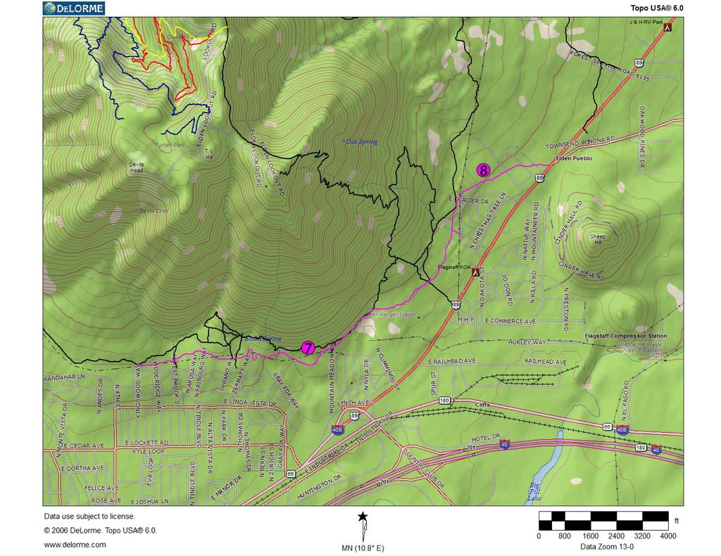
10 loop trail highlighting environmental and historic features in the area, a mountain bike skills area and/or event staging facilities. We have sent a letter to the City requesting that they partner with the Forest Service. Add a trail between the Schultz Creek Trail Head and the newly proposed Dry Lake Hills Loop. This will add an alternative to both Schultz Creek Trail and Rocky Ridge Trail to help disperse use and minimize user conflicts as well as maximizing the stacked-loops concept in the Dry Lake Hills. Additionally, as changes are made to Rocky Ridge trail per its class 3 designation as part of the Arizona Trail and Flagstaff Loop Trail, this trail will serve to replace the challenge opportunity formerly provided by Rocky Ridge. Please note that this trail would serve to replace multiple user created routes in this area, resulting in a net reduction of any environmental impacts. (#1 on our attached map) Move Lower Brookbank Trail from its currently proposed re-alignment to the east. We have hiked this area extensively and our alignment would make for a much better trail. (See above Comments on the components of the Proposed Action.) (#2 on our attached map) Add upper Red Onion trail into the system in the Preferred Alternative in the Draft Environmental Assessment. Red Onion is a vital connection to the MEDL trail system as it shortcuts the need to climb all the way to the top of Mt Elden to make loops. With the realignment of Upper Oldham, this connection becomes even more valuable. Red Onion is one of the oldest non-system trails in the MEDL area and has a very large amount of support amongst all trail users. Note that Red Onion would need connection across Elden LO Road to Upper Oldham. (#3 on our attached map) Add Ginger and Jedi Trails to the system. These trails provide an intermediate to advanced experience that is otherwise not available on the system. These trails appeal to a diverse array of riders as they are not built to the same degree of challenge as the downhill mountain bike trails. The Red Rock District has recently incorporated several trails with a similar degree of challenge, (Highline and Hangover for example), which has helped to address this demand in that area. Adding these two trails while eliminating other user created routes nearby will result in a net reduction in impacts in these areas. (#4 and #5 respectively on our attached map) Add a trail connecting the lower section of Sunset Trail to the top of Lower Brookbank to add further connectivity and versatility to the trail system. When coupled with the Dry Lake Hills Loops and the trail connecting from the DLH Loops to Schultz Creek Trailhead, this will provide an alternative to Schultz Creek Trail which will help to alleviate user conflict issues that continue to grow on Schultz Creek because of its popularity. Although Little Gnarly is a fine route, it is not single-track, it is an exceptionally challenging climb and it connects from a different place from this suggested trail. This trail travels through an area that has several old roads that are frequently used by cyclists. This route would be a better experience than those roads and provide access to this part of the Forest, potentially allowing for a net replacement should these old roads be decommissioned. (#6 on our attached map)
11 Align the re-designated Class 4 Flagstaff Loop Trail along the foot of Mount Elden on contours along the Pipeline corridor rather than where it is shown in the Proposed Action along Forces of Nature and other trails in the Environmental Study Area (the current FLT alignment). This will minimize impacts to the ESA and is a more appropriate placement for this trail type at the Forest-Community interface. (See above Comments on the components of the Proposed Action.) (#7 on our attached map) The Doney Park Multi-modal study completed in 2011 recommends a FUTS type extension from the end of the FUTS at Snowflake, across Forest Service land to the intersection of Townsend-Winona Road. The analysis for this folds perfectly into the MEDL planning. (#8 on our attached map) Thank you for taking the time to thoroughly review our input. We look forward to helping to shape this planning and to eventually assisting in any way that we can with the implementation of this project. Should you have any questions, please feel free to contact us. Sincerely- s/anthony Quintile For the Board of Flagstaff Biking Organization
12
13
14
Thank you for the opportunity to comment on the proposed action to add trails and trailheads to the Red Rock District trail system.
 July 14, 2010 Jennifer Burns Red Rock Ranger District PO Box 20429 Sedona, AZ 86341 Flagstaff Biking Organization PO Box 23851 Flagstaff, AZ 86002 Dear Jennifer- Thank you for the opportunity to comment
Thank you for this third opportunity to comment on the proposed revisions to the Coconino National Forest Management plan.
 March 19, 2014 Flagstaff Biking Organization PO Box 23851 Flagstaff, AZ 86002 Vern Keller Coconino National Forest Attn: Plan Revision 1824 South Thompson Street Flagstaff, Arizona 86001 coconino_national_forest_plan_revision_team@fs.fed.us
Thank you for this second opportunity to comment on the proposed revisions to the Coconino National Forest Management plan.
 March 8, 2011 Flagstaff Biking Organization PO Box 23851 Flagstaff, AZ 86002 Yewah Lau Coconino National Forest Attn: Plan Revision 1824 South Thompson Street Flagstaff, Arizona 86001 Sent via electronic
Logo Department Name Agency Organization Organization Address Information 5700 North Sabino Canyon Road
 Logo Department Name Agency Organization Organization Address Information United States Forest Coronado National Forest 5700 North Sabino Canyon Road Department of Service Santa Catalina Ranger District
Kelly Motorized Trails Project Proposed Action
 Kelly Motorized Trails Project Proposed Action November 28, 2011 The Flagstaff Ranger District of the Coconino National Forest is seeking public input on the proposed Kelly Motorized Trails Project (formerly
September 14, Comments of the Colorado Trail Foundation On the USFS Scoping Notice of August 13, 2010 RE: the relocation of the CDNST/CT Page 1
 THE COLORADO TRAIL FOUNDATION Comments on the U.S. Forest Service Scoping Notice of August 13, 2010 Regarding the Relocation of THE COLORADO TRAIL AND CONTINENTAL DIVIDE NATIONAL SCENIC TRAIL From La Garita
paraphrase: Supports consolidating sunset trailhead and restroom
 Bryan Andrada 12/5/2013 Email I am extremely excited to see the local FS integrate downhill specific trails in their new management plan New Trail Construction Downhill biking - General support 1 Warren
Preferred Recreation Recommendations Stemilt-Squilchuck Recreation Plan March 2018
 Preferred Recreation Recommendations Stemilt-Squilchuck Recreation Plan March 2018 Below are the recommended recreation ideas and strategies that package together the various recreation concepts compiled
ROAD AND TRAIL PROJECT APPROVAL
 ROAD AND TRAIL PROJECT APPROVAL www.marincountyparks.org Marin County Parks, 3501 Civic Center Dr, Suite 260, San Rafael, CA 94903 DATE: July 12, 2017 PRESERVE: Gary Giacomini Open Space Preserve PROJECT:
GATEWAY PHASE 2. U.S. Forest Service and the Mount Shasta Trails Association
 GATEWAY PHASE 2 U.S. Forest Service and the Mount Shasta Trails Association PROJECT DEVELOPMENT Brief history - Gateway Phase 1 - IMBA conceptual plan - BikeShasta: concert series - USFS & MSTA partnered
Trails Technical Committee
 Trails Technical Committee Winter 2017 Draft Report Alignment Proposals for the Inyo National Forest and the Town of Mammoth Lakes Map ID #S18 February 08, 2017 Map ID #S18 Key Agreements As of February
Table of Contents. page 3 Long term Goals Project Scope Project History. 4 User Groups Defined Trail Representative Committee. 5 Trail Users Breakdown
 Launched April 27th, 2010 1 Table of Contents page 3 Long term Goals Project Scope Project History 4 User Groups Defined Trail Representative Committee 5 Trail Users Breakdown 13 Trail Users Desires 16
Trail Phasing Plan. Note: Trails in the Clear Creek Canyon area (Segments will be finalized in the future to minimize wildlife impacts
 Note: Trails in the Clear Creek Canyon area (Segments 2 5 and a future JCOS connection) will be finalized in the future to minimize wildlife impacts Trail Phasing Plan P Parking 3 Easy Trail Intermediate
Hermosa Area Preservation The Colorado Trail Foundation 4/11/2008
 Hermosa Area Preservation The Colorado Trail Foundation 4/11/2008 Legend d o Tr ail NPA - National Protection Area ra NCA - National Conservation Area o e C Th The Colorado Trail lo FS inventoried Roadless
PLANNING COMMISSION AGENDA REPORT May 10, Members of the Planning Commission. Joyce Parker-Bozylinski, Contract Planner
 PLANNING COMMISSION AGENDA REPORT May 10, 2007 TO: FROM: PROPOSAL: APPLICANT: RECOMMENDATION: Members of the Planning Commission Joyce Parker-Bozylinski, Contract Planner Approval of the Calabasas Trails
Mt. Hood National Forest
 United States Department of Agriculture Forest Service Mt. Hood National Forest Zigzag Ranger District 70220 E. Highway 26 Zigzag, OR 97049 503-622-3191 Fax: 503-622-5622 File Code: 1950-1 Date: June 29,
Non-motorized Trail Plan & Proposal. August 8, 2014
 Town of Star Valley Ranch, Wyoming and the Star Valley Ranch Association in partnership with the USDA Forest Service, Bridger-Teton National Forest, Greys River Ranger District Non-motorized Trail Plan
Tracy Ridge Shared Use Trails and Plan Amendment Project
 Tracy Ridge Shared Use Trails and Plan Amendment Project Scoping Document Forest Service Allegheny National Forest Bradford Ranger District McKean, County, Pennsylvania In accordance with Federal civil
Nov. 19 th Public Workshop Summary
 On November 19 th, more than 60 community members attended an Open Space Matters workshop at the Linen Building in downtown Boise for over two hours. Participants learned about reserves, discussed the
The Chu property is a 6.57 acre parcel located in the Town of Superior on the west side of McCaslin Boulevard. In 2014, the Town of Superior acquired
 1 The Chu property is a 6.57 acre parcel located in the Town of Superior on the west side of McCaslin Boulevard. In 2014, the Town of Superior acquired the Chu property for open space with a contribution
Subj: POLICY FOR MAINSIDE TRAIL USE AT MARINE CORPS BASE QUANTICO
 UNITED STATES MARINE CORPS MARINE CORPS BASE QUANTICO, VIRGINIA 22134-5001 MCBO 5090.4 B 04 MARINE CORPS BASE ORDER 5090.4 From: Commander To: Distribution List Subj: POLICY FOR MAINSIDE TRAIL USE AT MARINE
Trail Assessment Report
 Trail Assessment Report Trail Options for the Bear Creek Canyon located in Pikes Peak Ranger District, Pike National Forest and on Colorado Springs Utility Lands Due to the presence of a unique species
Wallace Falls State Park Classification and Management Planning Stage 3 Preliminary Recommendations July 18, 2018 Sultan City Hall
 Wallace Falls State Park Classification and Management Planning Stage 3 Preliminary Recommendations July 18, 2018 Sultan City Hall Thanks for coming! This document contains State Parks preliminary recommendations
To: Cam Hooley From: Trails 2000 Date: September 30, 2016 Re: Hermosa Comments. Dear Cam:
 ! To: Cam Hooley From: Trails 2000 Date: September 30, 2016 Re: Hermosa Comments Dear Cam: Trails 2000 is commenting on the Forest Service Management Plan for the Hermosa Creek Watershed Management Plan
CHAPTER 5. Chapter 5 Recreation Element
 CHAPTER 5 Recreation Element Chapter 5 Recreation Element The Recreation Element of the Meyers Area Plan is a supplement to the Recreation Element of the TRPA Regional Plan and the El Dorado County General
Restore and implement protected status that is equivalent, or better than what was lost during the mid-1990 s
 THE ROSSLAND RANGE, OLD GLORY AREA. Executive summary. The Friends of the Rossland Range Society, on behalf of the local outdoor community, seeks to accomplish the following with respect to the Old Glory
BACKCOUNTRY TRAIL FLOOD REHABILITATION PROGRAM
 BACKCOUNTRY TRAIL FLOOD REHABILITATION PROGRAM Backcountry Trail Flood Rehabilitation A June 2013 Flood Recovery Program Summary In June 2013, parts of Southern Alberta were devastated from significant
RUSHMORE CONNECTOR TRAIL PROPOSAL
 PURPOSE AND NEED Background The U.S. Forest Service, Black Hills National Forest (Forest Service) has received a special use permit application from the State of South Dakota Department of Game, Fish and
Proposal to Redevelop Lower Kananaskis River-Barrier Lake. Bow Valley Provincial Park. Frequently Asked Questions
 Proposal to Redevelop Lower Kananaskis River-Barrier Lake Bow Valley Provincial Park Frequently Asked Questions What is being proposed? What are the details of the proposal? Where is the project area located?
Dungeness Recreation Area County Park Master Plan
 Dungeness Recreation Area County Park Public Outreach Meeting October 10, 2007 Project Overview USFWS Site Dungeness Recreation Area County Park Meeting Objectives: Re-Introduce project; provide status
13.1 REGIONAL TOURISM ISSUES AND SUMMARY OF FINDINGS
 13 REGIONAL TOURISM T he County of Mariposa s recreation needs and facilities fall within two categories: regional tourism and local recreation. This Element focuses on regional tourism issues related
Creating a User-Driven Long-Distance OHV Trail Through Partnering
 Joseph Raffaele Outdoor Recreation Planner U.S. Bureau of Land Management Yuma, Arizona Creating a User-Driven Long-Distance OHV Trail Through Partnering BLM is a multiple-use land management agency within
Georgetown-Lewes Rail/Trail Study. Rail/Trail Study: Cool Spring to Cape Henlopen State Park New Road Extension (House Resolution No.
 Georgetown-Lewes Rail/Trail Study Rail/Trail Study: Cool Spring to Cape Henlopen State Park New Road Extension (House Resolution No. 47) August 22, 2011 Presentation Outline Background Benefits Statewide
PROPOSED ACTION South 3000 East Salt Lake City, UT United States Department of Agriculture
 United States Department of Agriculture Forest Service Uinta-Wasatch-Cache National Forest Salt Lake Ranger District 6944 South 3000 East Salt Lake City, UT 84121 801-733-2660 File Code: 1950/2300 Date:
Chapter 6: POLICY AND PROCEDURE RECOMMENDATIONS
 Chapter 6 POLICY AND PROCEDURE RECOMMENDATIONS FOR SRRA Below are seven policy elements that should be considered for adoption by the Southwest Regional Recreation Authority of Virginia: 1. Develop strategies
RE: Access Fund Comments on Yosemite National Park Wilderness Stewardship Plan, Preliminary Ideas and Concepts
 September 30, 2016 Superintendent Yosemite National Park Attn: Wilderness Stewardship Plan P.O. Box 577 Yosemite, CA 95389 RE: Access Fund Comments on Yosemite National Park Wilderness Stewardship Plan,
A CASE FOR COMPLETING THE JORDAN RIVER PARKWAY: A
 A CASE FOR COMPLETING THE JORDAN RIVER PARKWAY: A safe crossing at 9000 South and 850 West Proposed 9000 South Underpass Parkway Timeline Parkway, Trail, and Tourism Facts Blueprint Jordan River 1971 1973
Continental Divide National Scenic Trail Legislative History and Planning Guidance
 Continental Divide National Scenic Trail Legislative History and Planning Guidance Legislation, Policy, and Direction Regarding National Scenic Trails The National Trails System Act, P.L. 90-543, was passed
FINAL TESTIMONY 1 COMMITTEE ON RESOURCES UNITED STATES HOUSE OF REPRESENTATIVES. July 13, 2005 CONCERNING. Motorized Recreational Use of Federal Lands
 FINAL TESTIMONY 1 STATEMENT OF DALE BOSWORTH CHIEF Of the FOREST SERVICE UNITED STATES DEPARTMENT OF AGRICULTURE Before the SUBCOMMITTEE ON FORESTS AND FOREST HEALTH And the SUBCOMMITTEE ON NATIONAL PARKS,
As outlined in the Tatshenshini-Alsek Park Management Agreement, park management will:
 Management Strategy General Strategy The priority management focus for the park is to ensure that its internationally significant natural, cultural heritage and recreational values are protected and that
Proposed Action. Payette National Forest Over-Snow Grooming in Valley, Adams and Idaho Counties. United States Department of Agriculture
 United States Department of Agriculture Forest Service January 2012 Proposed Action Payette National Forest Over-Snow Grooming in Valley, Adams and Idaho Counties Payette National Forest Valley, Adams
Blueways: Rivers, lakes, or streams with public access for recreation that includes fishing, nature observation, and opportunities for boating.
 Parks, Open Space and Trails PRINCE WILLIAM COUNTY 2008 COMPREHENSIVE PLAN TRAILS PLAN CONTENTS The components of the trails plan are: Intent Definitions Goals, Policies, and Action Strategies Trails Map
Mickelson Connector Feasibility Study
 Friends of the Norbeck PO Box 2003 Rapid City, SD 57709 www.friendsofthenorbeck.org Summary Comments on the Mickelson Connector Feasibility Study Prepared by Brian Brademeyer Submitted to Wyss Associates
APPENDIX D: SUSTAINABLE TRAIL DESIGN. APPENDICES Town of Chili Parks and Recreation Master Plan Update
 APPENDIX D: SUSTAINABLE TRAIL DESIGN APPENDICES Town of Chili Parks and Recreation Master Plan Update Sustainable Trail Construction Sustainable trails are defined by the US Forest Service as trails having
Discussion Paper: Development of a Plan for Trails on Public Land
 Discussion Paper: Development of a Plan for Trails on Public Land APRIL 2017 The purpose of this Discussion Paper is to summarize the status & issues relating to District trails and feedback to date, and
DRAFT - APRIL 13, 2007 ROUTING STUDY FOR TRAIL CONNECTIONS BETWEEN CALAIS AND AYERS JUNCTION
 DRAFT - APRIL 13, 2007 ROUTING STUDY FOR TRAIL CONNECTIONS BETWEEN CALAIS AND AYERS JUNCTION Abstract The vision for the East Coast Greenway is an off-road urban trail system running from Calais, Maine
Welcome to the future of Terwillegar Park a Unique Natural Park
 Welcome to the future of Terwillegar Park a Unique Natural Park 1 Introduction The Terwillegar Park Concept Plan study will develop an overall concept plan, management objectives and development guidelines
Superintendent David Uberuaga June 27, 2011 Grand Canyon National Park P.O. Box 129 Grand Canyon, AZ 86023
 Superintendent David Uberuaga June 27, 2011 Grand Canyon National Park P.O. Box 129 Grand Canyon, AZ 86023 Dear Superintendent Uberuaga, Thank you for the opportunity to provide scoping comments on Grand
MUNICIPALITY OF ANCHORAGE
 MUNICIPALITY OF ANCHORAGE ANCHORAGE PARKS & RECREATION Memorandum PRC 08-56 DATE: 5 August 2008 TO: FROM: SUBJECT: Parks & Recreation Commission Holly Spoth-Torres, Park Planner PRC 08-56 Far North Bicentennial
S Central Coast Heritage Protection Act APRIL 21, 2016
 STATEMENT OF GLENN CASAMASSA ASSOCIATE DEPUTY CHIEF, NATIONAL FOREST SYSTEM U.S. FOREST SERVICE U.S. DEPARTMENT OF AGRICULTURE BEFORE THE UNITED STATES SENATE COMMITTEE ON ENERGY AND NATURAL RESOURCES
MORGAN CREEK GREENWAY Final Report APPENDICES
 APPENDICES MORGAN CREEK GREENWAY Appendix A Photos of Existing Conditions in Trail Corridor Photos of existing conditions Main trail corridor - February 2009 Photos of existing conditions south bank Morgan
City of Durango 5.8 FUNDING TRAILS DEVELOPMENT
 5.8 FUNDING TRAILS DEVELOPMENT The City has been successful in establishing dedicated local funding sources as well as applying for grants to develop the City s trail system, having received nearly $2.4
Hudson Highlands Fjord Trail Draft Master Plan. April 29, 2015
 Hudson Highlands Fjord Trail Draft Master Plan April 29, 2015 Agenda Route Overview Proposed Segment Results of Community Survey on that Segment Next Steps Municipal Endorsement Environmental Review Implementation
Rogue River Access and Management Plan Draft Alternatives
 Rogue River Access and Management Plan Draft Alternatives The Rogue River Access and Management Plan was initiated in December, 2011 and is being led by Jackson County Parks (JCP) and Oregon Department
White Mountain National Forest Saco Ranger District
 United States Department of Agriculture Forest Service White Mountain National Forest Saco Ranger District 33 Kancamagus Highway Conway, NH 03818 Comm: (603) 447-5448 TTY: (603) 447-3121 File Code: 1950
Bibbulmun Track. Cape to Cape Track. Two of the world s great long distance walking tracks. 973 km. 135 km km Off-road cycle touring
 Trail revitalising Western Australia Bibbulmun Track 973 km Cape to Cape Track 135 km Two of the world s great long distance walking tracks 1062 km Off-road cycle touring Trail revitalising 1. Framework
Proposal to Redevelop Lower Kananaskis River-Barrier Lake. Bow Valley Provincial Park
 Frequently Asked Questions Proposal to Redevelop Lower Kananaskis River-Barrier Lake Bow Valley Provincial Park Frequently Asked Questions What has been decided? What are the details of the plan? What
Bear Creek Habitat Improvement Project
 06/10/10 Bear Creek Habitat Improvement Project El Paso County, Colorado Pike National Forest and Colorado Springs Utilities Owned Land Report prepared by: Eric Billmeyer Executive Director Rocky Mountain
SOUTH INTERCHANGE AREA
 Santaquin City General Plan 1 Location and Characteristics The South Interchange Area of Santaquin is located west of Interstate 15 and south of 500 South (Figure 1). It includes properties already annexed
PEMBERTON VALLEY RECREATIONAL TRAILS MASTER PLAN UPDATE Community Open House. April 2018
 PEMBERTON VALLEY RECREATIONAL TRAILS MASTER PLAN UPDATE Community Open House April 2018 Introductions Introductions Matt Bakker, BHA Project Coordinator Other Team Members: Liz Scroggins, Grey Owl Consulting
Final Environmental Impact Statement for the Merced Wild and Scenic River. Comprehensive Management Plan, Yosemite National Park, Madera and Mariposa
 This document is scheduled to be published in the Federal Register on 02/26/2014 and available online at http://federalregister.gov/a/2014-04061, and on FDsys.gov DEPARTMENT OF THE INTERIOR 4312-FF NATIONAL
Land Management Summary
 photo credit: ANGAIR Anglesea Heath Land Management Summary The Anglesea Heath (6,501 ha) was incorporated into the Great Otway National Park in January 2018. This provides an opportunity to consider the
HLUET TRANSMITTAL RECOMMENDED ACTION
 HLUET TRANSMITTAL TO: Housing, Land Use, Environment & Transportation Committee Prepared by: Elish Ryan, Park Planner FROM: Lisa Killough, Director DATE: November 1, 2002 Reviewed by: Mark Frederick, Planning
BACKGROUND DECISION. Decision Memo Page 1 of 6
 DECISION MEMO DEVIL S ELBOW BY-PASS, BOUNDARY TRAIL NO.1 U.S. FOREST SERVICE T9N, R7E, SECTION 9 RANGE 5E COWLITZ COUNTY WA MOUNT ST. HELENS NATIONAL VOLCANIC MONUMENT, GIFFORD PINCHOT NATIONAL FOREST
Tallahassee-St. Marks Historic Railroad Trail
 Revitalizing a Historic Trail Designated as a National Recreation Trail, the 16-mile Tallahassee-St. Marks Historic Railroad Trail has been enjoyed by countless bicyclists, runners, and outdoor enthusiasts
WELCOME to the Iditarod Dog Sledding Historic District (IDSHD) Workshop. January 11, Houston Middle School Houston, Alaska
 Workshop. January 11, Houston Middle School Houston, Alaska") WELCOME to the Iditarod Dog Sledding Historic District (IDSHD) Workshop January 11, 2012 Houston Middle School Houston, Alaska Workshop Purpose: Present/discuss proposed resolutions to comments received
WELCOME to the Iditarod Dog Sledding Historic District (IDSHD) Workshop January 11, 2012 Houston Middle School Houston, Alaska Workshop Purpose: Present/discuss proposed resolutions to comments received
Proposed Peninsula Bay Bike Track Development
 Proposed Peninsula Bay Bike Track Development May 2018 BACKGROUND The area of land at the northern extreme of Wanaka's Peninsula Bay development (Lot 923 DP 501325), currently owned by Infinity Investment
GOLDEN EARS PROVINCIAL PARK
 GOLDEN EARS PROVINCIAL PARK Trail Information as of October 10 th 2015 Do not underestimate the mountainous wilderness of Golden Ears Provincial Park. The combination of rugged terrain and rapidly changing
Assessing Your Trails, Keeping Them Safe and Enjoyable
 Jon Wood, PLA, ASLA Associate Vice President Stewart Bert Lynn, PLA, ASLA, LEED AP Project Manager Mecklenburg County Asset and Facility Management Assessing Your Trails, Keeping Them Safe and Enjoyable
A number of goals were identified during the initial work on this Big Lake Transportation Plan.
 C. Transportation General Background Information Big Lake s transportation system includes all the roads, paths and facilities that allow the movement of private vehicles, trains and planes, as well as
Regional Wayfinding Sign Strategy Thurston County Trails 2017
 Regional Wayfinding Sign Strategy Thurston County Trails 2017 Partners: Members and partnering organizations of the Thurston Thrives Community Design Action Team City of Lacey, City of Olympia, City of
March 14, SUBJECT: Public input to the Bureau of Land Management, Gunnison Field Office, Travel Management Plan
 March 14, 2019 Delivered via email to ewaters@blm.gov Elijah Waters Field Manager BLM Gunnison Field Office Gunnison, CO 81230 SUBJECT: Public input to the Bureau of Land Management, Gunnison Field Office,
Business Item No XXX. Proposed Action That the Metropolitan Council approve the Coon Creek Regional Trail Master Plan.
 Business Item No. 2015-XXX Metropolitan Parks and Open Space Commission Meeting date: July 7, 2015 For the Community Development Committee meeting of July 20, 2015 For the Metropolitan Council meeting
5.0 OUTDOOR RECREATION OPPORTUNITIES AND MANAGEMENT
 5.0 OUTDOOR RECREATION OPPORTUNITIES AND MANAGEMENT 5.1 Introduction This section describes the range of recreational activities that currently take place in Marble Range and Edge Hills Parks, as well
Wilds. Headwaters. Lakes. Oxbows. Falls
 56 5 4 3 Wilds Headwaters Lakes Oxbows Falls 57 Zones It could be said the on-the-ground essence of this master plan appears within the next 6 pages of this report. As we learned in the preceding Cultural
DECISION MEMO. Rawhide Trail #7073 Maintenance and Reconstruction
 Page 1 of 6 Background DECISION MEMO USDA Forest Service Jefferson Ranger District Jefferson County, Montana Rawhide Trail #7073 is located in the Elkhorn Mountain Range approximately 10 miles east of
Proposed Action Kaibab Campground Capital Improvement Project September 2008
 Background Kaibab Campground Capital Improvement Project September 2008 The Williams Ranger District of the Kaibab National Forest is proposing to improve the Kaibab Lake Campground. Kaibab Lake Campground
Bradley Brook Relocation Project. Scoping Notice. Saco Ranger District. United States Department of Agriculture Forest Service
 Bradley Brook Relocation Project United States Department of Agriculture Forest Service Scoping Notice White Mountain National Forest February 2011 For Information Contact: Jenny Burnett White Mountain
BOAT DOCKS AND LAUNCHES. Public Engagement Report July 2015
 BOAT DOCKS AND LAUNCHES Public Engagement Report July 2015 TABLE OF CONTENTS BACKGROUND 3 STAKEHOLDER CONSULTATION 6 PARTICIPANT PROFILE 7 RESPONSE THEMES 8 CONCLUSION 16 BACKGROUND The North Saskatchewan
EXECUTIVE SUMMARY PROGRAM DEVELOPMENT REPORT PURPOSE EXISTING SETTING EXPANDING PARKLAND
 EXECUTIVE SUMMARY PROGRAM DEVELOPMENT REPORT PURPOSE As the culmination of the first phase of the master planning process, this Program Development Report creates the framework to develop the Calero County
RECREATION. 1. Conflict between motorized and non-motorized recreation uses,
 Island Unit Trail System Additions Project Chapter 3. Recreation RECREATION INTRODUCTION This section discusses the effects to public recreation opportunities and experiences. The type of recreational
Hiawatha National Forest St. Ignace Ranger District. File Code: 1950 Date: August 5, 2011
 United States Department of Agriculture Forest Service Hiawatha National Forest St. Ignace Ranger District W1900 West US-2 St. Ignace, MI 49781 906-643-7900 File Code: 1950 Date: August 5, 2011 Dear National
PROPOSED PARK ALTERNATIVES
 8 Chimne y Rock State Park M a ster Pl an 2011 PROPOSED PARK ALTERNATIVES Introduction Three different park development concepts were prepared and presented to the citizens of North Carolina through a
Appendix 3. Greenway Design Standards. The Whitemarsh Township Greenway Plan
 Appendix 3 Greenway Design Standards This chapter discusses two design standards for the greenway types discussed above. First, trail design standards are presented together with trailhead facilities and
Decision Memo for Desolation Trail: Mill D to Desolation Lake Trail Relocation
 for Salt Lake County, Utah Uinta-Wasatch-Cache National Forest Salt Lake Ranger District 1. Background The present location of the Desolation Trail (#1159) between Mill D and Desolation Lake follows old
Understanding user expectations And planning for long term sustainability 1
 Understanding user expectations And planning for long term sustainability 1 What is a natural surface trail? It can be as simple has a mineral soil, mulched or graveled pathway, or as developed as elevated
Greater Minnesota Regional Parks and Trails Commission Designation Application
 Greater Minnesota Regional Parks and Trails Commission Designation Application General Section Designation Application #: 15-050D Date Submitted: 06/30/2015 Park or Trail Name: Perham to Pelican Rapids
NATIONAL PARK SERVICE CERTIFICATION OF COMPLETED SEGMENTS OF THE NORTH COUNTRY NATIONAL SCENIC TRAIL
 NATIONAL PARK SERVICE CERTIFICATION OF COMPLETED SEGMENTS OF THE NORTH COUNTRY NATIONAL SCENIC TRAIL Completed trail segments that (1) follow the route identified in the 1982 National Park Service (NPS)
Williamson Rock/Pacific Crest National Scenic Trail (PCT) Project EIS. Notice of intent to prepare an Environmental Impact Statement.
 Project EIS. Notice of intent to prepare an Environmental Impact Statement.") [3411-15-P] DEPARTMENT OF AGRICULTURE Forest Service Angeles National Forest; Los Angeles County, CA Williamson Rock/Pacific Crest National Scenic Trail (PCT) Project EIS AGENCY: ACTION: Forest Service,
[3411-15-P] DEPARTMENT OF AGRICULTURE Forest Service Angeles National Forest; Los Angeles County, CA Williamson Rock/Pacific Crest National Scenic Trail (PCT) Project EIS AGENCY: ACTION: Forest Service,
Steps in the Management Planning Process
 Steps in the Management Planning Process Developing a management plan for Kalamalka Lake Park will follow a multi-stage process. The planning process for this park is currently in the Draft Management
College Forests Recreation Planning Focus Group Results Summary, Spring 2013
 Broad Themes by Prevalence 1) Trails 2) University Relations & Management 3) User Conflict 4) Access 5) Use Types and Extent 6) Ecology 7) Change 8) Information & Education College Forests Recreation Planning
Longmont to Boulder Regional Trail Jay Road Connection DRAFT FINAL REPORT
 Longmont to Boulder Regional Trail Jay Road Connection DRAFT FINAL REPORT December 2018 Project Summary Boulder County, Colorado, in partnership with the City of Boulder, is evaluating options for multi-use
Briarhill Neighborhood Polecat Priority List. Exhibit D-4
 Briarhill Neighborhood Polecat Priority List Exhibit D-4 March 11, 2013 The following list of trail head issues and design elements was developed by Briarhill 2/3 neighborhood residents living near the
Coronado National Forest Santa Catalina Ranger District
 United States Department of Agriculture Forest Service Coronado National Forest Santa Catalina Ranger District File Code: 1950 Date: October 14, 2015 Dear Interested Party: The Santa Catalina Ranger District
Buffalo Pass Trails Project
 Buffalo Pass Trails Project Hahns Peak/Bears Ears Ranger District, Medicine Bow-Routt National Forests and Thunder Basin National Grassland Routt County, Colorado T6N 83W Sections 3-5, 8; T6N 84W Sections
Welcome and thank you for being here! Kick-Off Public Workshop November 19, 2014
 Welcome and thank you for being here! Kick-Off Public Workshop November 19, 2014 OPEN SPACE MATTERS: Boise s First Reserve Master Plan Julia Grant Foothills and Open Space Manager City of Boise Ellen Campfield
Minnesota Off-Road Cyclists
 Minnesota Off-Road Cyclists MORC Mission Minnesota Off-Road Cyclists is a nonprofit volunteer organization dedicated to safeguarding the future of mountain biking in Minnesota through the promotion of
Project Planning, Compliance, and Funding
 Project Planning, Compliance, and Funding The plans above offer high level guidance to ensure that the A.T. is managed effectively as a whole unit in a decentralized management structure. Cooperative management
Dear Reviewing Officer:
 From: To: Subject: Date: Attachments: Peter Hart FS-r02admin-review Objection Re: Maroon Bells Snowmass Wilderness Overnight Visitor Use Management Plan Monday, August 14, 2017 8:38:01 PM Final Objection
April 10, Mark Stiles San Juan Public Lands Center Manager 15 Burnett Court Durango, CO Dear Mark,
 Mark Stiles San Juan Public Lands Center Manager 15 Burnett Court Durango, CO 81301 Dear Mark, We are pleased to offer the following comments on the draft San Juan Public Lands Center management plans