A GIS Assessment of Erosion Vulnerability for Unofficial Trails in the Columbia River Gorge
|
|
|
- Cassandra Wiggins
- 5 years ago
- Views:
Transcription

1 A GIS Assessment of Erosion Vulnerability for Unofficial Trails in the Columbia River Gorge Sachi Arakawa Geog 593 Digital Terrain Analysis Fall 2017
2 Abstract The city of North Bonneville, located along the Columbia River Gorge in Skamania County, Washington, is a small town surrounded by scenic natural landscapes. Community leaders of North Bonneville have a vision of becoming a hub for outdoor recreation and a connector to the Pacific Crest Trail and other regional trails. In an effort to advance their vision, a recently founded local community organization named the Bonneville Trails Foundation (BTF) is encouraging the United States Forest Service (USFS) to approve and formalize several existing unofficial trails located just north of the town, known to locals as the Aldrich Butte trail complex. In April of 2017 a focus group was held with community members, trail builders, and the USFS to get feedback about which of the informal trails should be formalized. Following that process, further analysis of trail hazards was requested by the USFS. There are many criteria that the USFS and WTA would like to consider when choosing where to build trails in this area. However, for the scope of this project I will be doing a GIS analysis of the vulnerability of trails to erosion processes to access potential hazards and sensitive areas in the trail complex. I will use a model developed by Józefaciuk & Józefaciuk (1996), Wawer & Nowocien (2007), and A.M. Tomczyk, (2011) that uses slope steepness and soil type to determine water erosion hazards. The potential water erosion indicator is based on soil properties as defined by Wawer & Nowocien (2007). I will determine slope by using a 2 meter DEM obtained from the Washington Department of Natural Resources, and use a soil classification layer from the Soil Survey Geographic (SSURGO) database obtained from the U.S. Department of Agriculture to determine soil type. Trails will be segmented, and each segment assigned a hazard ranking. Finally, each of the unofficial trails will be evaluated for overall erosion vulnerability, and recommendations will be made toward a trail formalization process.

3 Study Area: North Bonneville, WA Unofficial trail system (shhh, it s a secret)

4 Bonneville Trail Foundation (BTF) Other important partners
5 1. Which trails of North Bonneville s unofficial trail complex would the community want to formalize? 2. Are these trails actually viable for the formalization process a. Are they safe for people? b. Are they safe for the environment? c. What about land ownership? d. etc


6 Mapping the Unofficial Trails: + = BTF Trail Gnomes Garmin GPS Unit (not to scale)

7 Resulting map of the unofficial trails (7 total)


8 Public Participation in Trail Selection & Evaluation Focus group in North Bonneville 1 hour, 16 participants Expert, Intermediate, and Novice users Representatives from the Forest Service, Army Corps of Engineers, and Washington Trails Association
9 Now what can GIS analysis tell us? Land Use Environmental Vulnerability Potential Hazards (Landslides, Erosion)
10 Process Outline: Gather Data Lit Review for Appropriate Model Analysis Conclusions
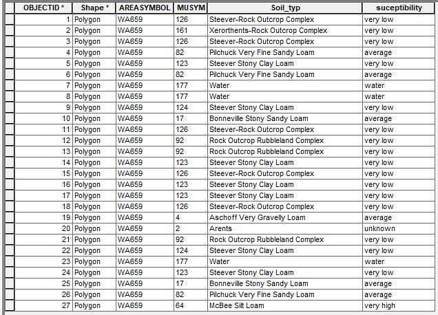
11 Data LiDAR/DEM/DTM at WADNR s Lidar Portal: Soil data from Web Soil Survey (WSS): Trail, road, land use, and stream/river data from the Friends of the Columbia Gorge, U.S. Forest Service and Washington Trails Association


12 Identifying an Appropriate Model Aleksandra M. Tomczyk Very simplified for my project
13 Process Breakdown 1. Divide trail system into equal segments, rasterize 2. Calculate slope and flow accumulation calculation for study area a. Identify stream networks 3. Vulnerability Ranking a. Reclassify slope and soil type data b. Combine tool to get new values 4. Zonal statistics to find pour points 5. Watershed delineation 6. Zonal statistics to aggregate vulnerability ranking to watershed 7. Join zonal statistics table to trail data

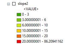
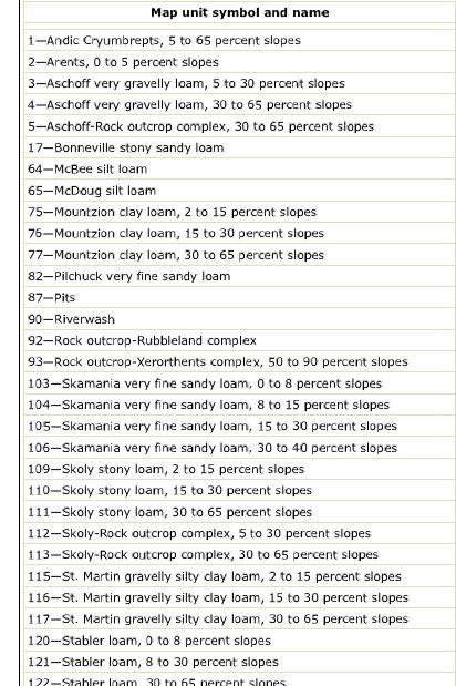
14 Vulnerability Ranking Step 1 Reclassify Values Soil Slope

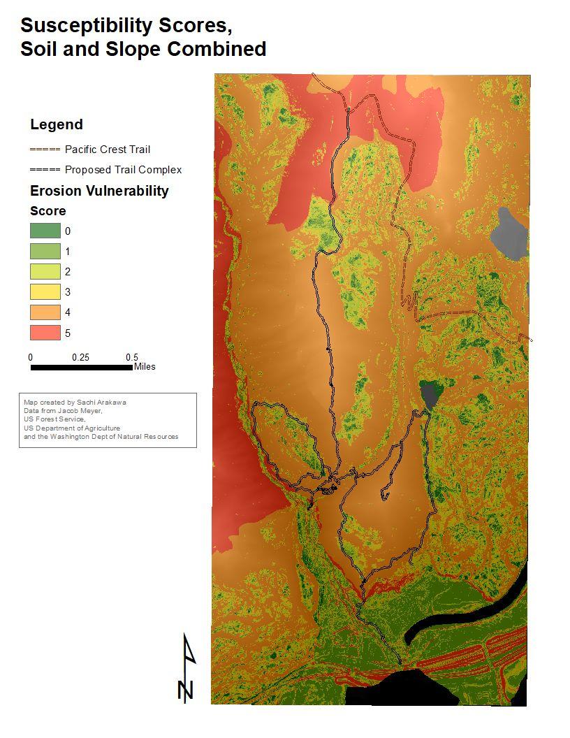
15 Vulnerability Ranking Step 2 Combine Tool
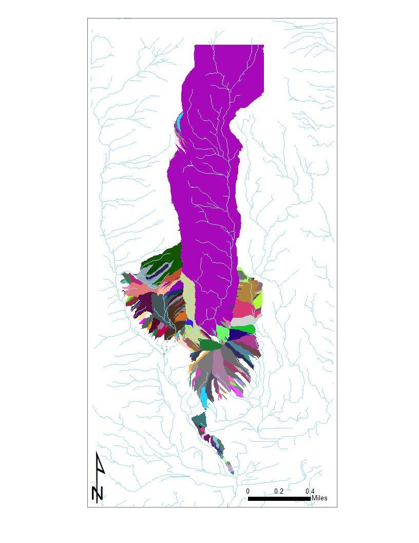
16 Vulnerability Map
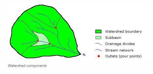
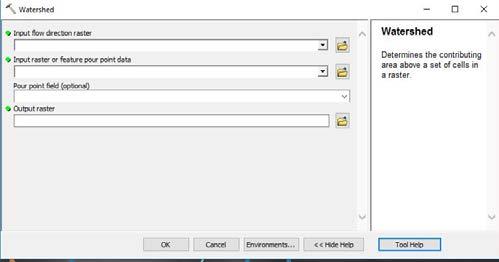
17 Delineate Watersheds Along Trail Complex


18 Zonal Statistics Vulnerability Values Aggregated to Watersheds by Sum Sum
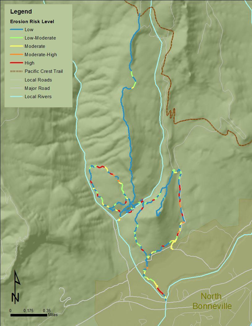
19 Results

20 Results Trails Most Vulnerable to Erosion: 1. Cedar Mountain to PCT Connect 2. Cedar Falls 3. Cedar to Hamilton Loop 4. West Aldrich Summit/Cedar Creek Access 5. Cedar/Hamilton Creek Confluence 6. East Aldrich 7. Proposed N. Bonneville to PCT Connection

21 Conclusion Several trails in the complex are vulnerable to erosion. Trails crossing creeks tended to be more vulnerable, but not exclusively. Results matched hazard areas that were pointed out during our focus group (ground truth)
22 Lessons Learned/Best Practices 1. Scope project conservatively 2. Chose model with discretion (ask an expert! ask two!) 3. Be aware of spatial resolution discrepancies 4. No analysis is complete without groundtruthing
23 Sources Pickering, Catherine Marina and Norman, Patrick. Comparing impacts between formal and informal recreational trails. Journal of Environmental Management Vol 193 (2017). Pages Tomczyk, Aleksandra. A GIS assessment and modelling of environmental sensitivity of recreational trails: The case of Gorce National Park, Poland. Applied Geography Vol 31 (2011). Pages Józefaciuk, A., & Józefaciuk, C. (1996). Erosion processes studies: Mechanism and applied methodology. Warszawa: Panst. Insp. Ochr. Srod. ser. Biblioteka Monitoringu Srodowiska Wawer R. and Nowocień E. Digital Map of Water Erosion Risk in Poland: A Qualitative, Vector-Based Approach. Polish Journal of Environmental Studies Vol. 15 No. 5 (2007). Pages Thanks to Bonneville Trails Foundation, Jake Meyer, Renee Tkach, and the community of North Bonneville.
Digital Terrain Analysis of Archer Mountain
 Digital Terrain Analysis of Archer Mountain Identifying a potential new recreational trail Photo: Justin Bush GEOG 593 - Duh Marcus Tobey Justin Bush Project Overview Background Project Area Overview Questions
A GIS Analysis of Probable High Recreation Use Areas in Three Sisters Wilderness Deschutes and Willamette National Forests
 Lindsey Kiesz Geo 565 Term Project 3/15/2010 A GIS Analysis of Probable High Recreation Use Areas in Three Sisters Wilderness Deschutes and Willamette National Forests Introduction The Three Sisters Wilderness
DIGITAL TERRAIN AND VIEWSHED ANALYSIS CRATER LAKE NATIONAL PARK
 DIGITAL TERRAIN AND VIEWSHED ANALYSIS OF FINDING THE IDEAL CAMPSITE ALONG THE PACIFIC CREST TRAIL Source: Outdoor Travel Blog DON RYAN DIGITAL TERRAIN ANALYSIS GEOG 593 PROJECT OVERVIEW LOCATION HISTORY
Disaster Evacuation Safe Zones in Clackamas County, Oregon Analysis: Two Scenarios
 Disaster Evacuation Safe Zone Analysis for Clackamas County, Oregon Part One: Caroline Rouwalk Part Two: Kathy Jepson June 3, 2008 http://gallery.photo.net/photo/5297534-md.jpg Disaster Evacuation Safe
A GEOGRAPHIC ANALYSIS OF OPTIMAL SIGNAGE LOCATION SELECTION IN SCENIC AREA
 A GEOGRAPHIC ANALYSIS OF OPTIMAL SIGNAGE LOCATION SELECTION IN SCENIC AREA Ling Ruan a,b,c, Ying Long a,b,c, Ling Zhang a,b,c, Xiao Ling Wu a,b,c a School of Geography Science, Nanjing Normal University,
Satisfying the Need: Finding Potential Campsite Locations in Farewell Canyon, B.C. Alexis Moore
 Satisfying the Need: Finding Potential Campsite Locations in Farewell Canyon, B.C. Alexis Moore 230075923 Geog 413 Final Project Write- Up Roger Wheate April. 13, 2012 Introduction & Purpose of Study The
BACKGROUND DECISION. Decision Memo Page 1 of 6
 DECISION MEMO DEVIL S ELBOW BY-PASS, BOUNDARY TRAIL NO.1 U.S. FOREST SERVICE T9N, R7E, SECTION 9 RANGE 5E COWLITZ COUNTY WA MOUNT ST. HELENS NATIONAL VOLCANIC MONUMENT, GIFFORD PINCHOT NATIONAL FOREST
Southern Shenandoah Valley Chapter
 Southern Shenandoah Valley Chapter June 7, 2018 Members of the State Water Control Board c/o Office of Regulatory Affairs, Department of Environmental Quality P.O. Box 1105 Richmond, Virginia 23218 citizenboards@deq.virginia.gov
Watershed Report Blue Mountain Lake-Petit Jean River
 Watershed Report Blue Mountain Lake-Petit Jean River 1111020402 The Center for Advanced Spatial Technologies at the University of Arkansas has developed the Arkansas Automated Reporting and Mapping System
USGS Efforts to Consolidate Geospatial Data in the Federal Government
 ++ 1 USGS Efforts to Consolidate Geospatial Data in the Federal Government An overview of USGS trails collaborations and updates. Date 5/31/2017 Greg Matthews + Introduction USGS The following slides provide
USE OF 3D GIS IN ANALYSIS OF AIRSPACE OBSTRUCTIONS
 USE OF 3D GIS IN ANALYSIS OF AIRSPACE OBSTRUCTIONS A project by by Samuka D. W. F19/1461/2010 Supervisor; Dr D. N. Siriba 1 Background and Problem Statement The Airports in Kenya are the main link between
Kit Carson-Challenger Ridge Trail Project
 Kit Carson-Challenger Ridge Trail Project Project Accomplishments Report-USFS December 15, 2015 Photo courtesy of Justin Peterson 815 South 25 th Street, Suite 101 Colorado Springs, CO 80904 Dedicated
Social Community Accessibility
 Social Community Accessibility Australian Geography Teachers Conference 8-12 January University of Tasmania Launceston NEIL COFFEE UNIVERSITY OF ADELAIDE Geography V GIS? National Centre for Social Applications
Mud Creek and West Mud Creek
 Mud Creek and West Mud Creek Recreational Use Attainability Analysis Summary of Findings Texas Institute for Applied Environmental Research Stephenville, Texas September 15, 2014 1 Project Partners Texas
Physical and Facilities Factors Influencing Tourist Distribution in Bantul Regency, Special Region of Yogyakarta
 E3S Web of Conferences 73, 03002 (208) Physical and Facilities Factors Influencing Tourist Distribution in Bantul Regency, Special Region of Yogyakarta Akhmad Shidiq Darajat, M. H. Dewi Susilowati 2 *
Melinda McCoy, CDM Project Manager Jonathan Posner, CDM Steven Wolosoff, CDM Don Schroeder, CDM
 A Task 8-1 GIS List of Lands for BMPs for North Santa Monica Bay Regional Watershed Implementation Plan and Malibu Creek Watershed Bacteria TMDL Implementation Plan To: From: Carolina Hernandez, of Watershed
Chapter 4.0 Alternatives Analysis
 Chapter 4.0 Alternatives Analysis Chapter 1 accumulated the baseline of existing airport data, Chapter 2 presented the outlook for the future in terms of operational activity, Chapter 3 defined the facilities
along a transportation corridor in
 Rockfall hazard and risk assessment along a transportation corridor in the Nera Valley, Central Italy Presentation on the paper authored by F. Guzzetti and P. Reichenbach, 2004 Harikrishna Narasimhan Eidgenössische
Trail Assessment Report
 Trail Assessment Report Trail Options for the Bear Creek Canyon located in Pikes Peak Ranger District, Pike National Forest and on Colorado Springs Utility Lands Due to the presence of a unique species
Hotel Location Analysis using ArcGIS
 Hotel Location Analysis using ArcGIS Yang Yang Department of Geography University of Florida Outline Introduction Background Data Source Research Methodology Preliminary Result Introduction Location! Location!
MEETING CONCLUSIONS. Andean South America Regional Meeting Lima, Peru 5-7 March ECOTOURISM PLANNING
 MEETING CONCLUSIONS Andean South America Regional Meeting Lima, Peru 5-7 March 2002 1.0 ECOTOURISM PLANNING 1.1 Protected Areas Ecotourism in Protected Areas is part of an integrated vision of tourism
Recapturing the Spatial Dynamics of the Venetian Occupation Period
 Recapturing the Spatial Dynamics of the Venetian Occupation Period of Merabello in Eastern Crete through a GIS Approach MARIANNA KATIFORI'-^ ' University of Crete, Dept. of History & Archaeology and Dept.
Land Figures & Spatial Data Infrastructure in KOSOVO
 Land Figures & Spatial Data Infrastructure in KOSOVO Idriz SHALA idriz.shala@gmail.com GIS -expert Afrim SHARKU afrim.sharku@gmail.com Land Management - Expert Kick-off meeting of the Regional Expert Advisory
Travel and Tourism in Ukraine: Key Trends and Opportunities to 2016
 Travel and Tourism in Ukraine: Key Trends and Opportunities to 2016 Reference code: TT0037MR_SP Published: July 2012 www.timetric.com Timetric John Carpenter House 7 Carmelite Street London EC4Y 0BS United
Robson Valley Avalanche Tract Mapping Project
 Robson Valley Avalanche Tract Mapping Project Prepared for: Chris Ritchie Ministry of Water Land and Air Protection 325 1011 4th Avenue Prince George, BC. V2L3H9 and Dale Seip Ministry of Forests 1011
Partners: Michigan California Timber Company Shasta-Trinity National Forest Pacific Crest Trail Association The Trust for Public Land
 Partners: Michigan California Timber Company Shasta-Trinity National Forest Pacific Crest Trail Association The Trust for Public Land Describe the project location, size, opportunities, and timing. Provide
The Chu property is a 6.57 acre parcel located in the Town of Superior on the west side of McCaslin Boulevard. In 2014, the Town of Superior acquired
 1 The Chu property is a 6.57 acre parcel located in the Town of Superior on the west side of McCaslin Boulevard. In 2014, the Town of Superior acquired the Chu property for open space with a contribution
DRAFT AN ANALYSIS OF ROADS, TRAILS, AND ROADLESS AREAS ON THE SUPERIOR NATIONAL FOREST, MINNESOTA
 DRAFT AN ANALYSIS OF ROADS, TRAILS, AND ROADLESS AREAS ON THE SUPERIOR NATIONAL FOREST, MINNESOTA Pacific Biodiversity Institute AN ANALYSIS OF ROADS, TRAILS, AND ROADLESS AREAS ON THE SUPERIOR NATIONAL
Arizona National Scenic Trail
 1 The Arizona National Scenic Trail is an 800 mile recreation trail from Mexico to Utah that connects mountain ranges, canyons, deserts, forests, wilderness areas, historic sites, trail systems, points
Lagunitas Creek Watershed Sediment Reduction and Enhancement Project Final Report
 Lagunitas Creek Watershed Sediment Reduction and Enhancement Project Final Report Presented: April 4, 2007 To: Marin Municipal Water District 220 Nellen Avenue Corte Madera, CA 94925 By: Patrick Kelleher
Environmental Development of River Road Ranch
 Environmental Development of River Road Ranch New Braunfels, Texas Alix Scarborough GEO 3426 April 2012 Introduction The 2,400-acre Word-Borcher ranch has been owned by the Word family since 1941. Located
Recreationists on the Gifford Pinchot National Forest: A Survey of User Characteristics, Behaviors, and Attitudes
 Recreationists on the Gifford Pinchot National Forest: A Survey of User Characteristics, Behaviors, and Attitudes by Alan R. Graefe The Pennsylvania State University Robert C. Burns University of Florida
National Scenic Byways Program US Department of Transportation
 1 2 National Scenic Byways Program US Department of Transportation Abstract The Cowlitz-Wahkiakum Council of Governments in partnership with Cowlitz, Skamania and Lewis Counties and the U.S. Forest Service,
Trails Technical Committee
 Trails Technical Committee Winter 2017 Draft Report Alignment Proposals for the Inyo National Forest and the Town of Mammoth Lakes Map ID #S18 February 08, 2017 Map ID #S18 Key Agreements As of February
Waukegan & Calumet Rivers. All Hands Meeting
 Waukegan & Calumet Rivers 516(e) Update All Hands Meeting David F. Bucaro, P.E. Chief, Economic Formulation & Analysis Section, Planning Branch May 18 th, 2011 Kensington Court Ann Arbor, MI 1 2 Waukegan
2009 Muskoka Airport Economic Impact Study
 2009 Muskoka Airport Economic Impact Study November 4, 2009 Prepared by The District of Muskoka Planning and Economic Development Department BACKGROUND The Muskoka Airport is situated at the north end
Decision Memo for Desolation Trail: Mill D to Desolation Lake Trail Relocation
 for Salt Lake County, Utah Uinta-Wasatch-Cache National Forest Salt Lake Ranger District 1. Background The present location of the Desolation Trail (#1159) between Mill D and Desolation Lake follows old
Prof. Dr Željko Vaško Doc. Dr Tihomir Predić MSc Boris Marković
 First Interim Meeting of the Regional Expert Advisory Working Group on Areas with Natural Constrains Prof. Dr Željko Vaško Doc. Dr Tihomir Predić MSc Boris Marković 29 th June 01 th July, 2016 Andrevlje,
Watershed Report Lower Eleven Point River
 Watershed Report Lower Eleven Point River 1101001104 The Center for Advanced Spatial Technologies at the University of Arkansas has developed the Arkansas Automated Reporting and Mapping System with funding
Kit Carson-Challenger Ridge Trail Project Annual Performance Report-2014 October 22, 2014
 1 Kit Carson-Challenger Ridge Trail Project Annual Performance Report-2014 October 22, 2014 Willow Lake and Kit Carson Peak 2 SUMMARY The Rocky Mountain Field Institute began Phase 1 of a multi-phase,
Susitna-Watana Hydroelectric Project (FERC No ) Recreation Resources Study Study Plan Section Study Implementation Report
 Recreation Resources Study Study Plan Section Study Implementation Report") (FERC No. 14241) Recreation Resources Study Study Plan Section 12.5 2014 Study Implementation Report Prepared for Prepared by AECOM November 2015 TABLE OF CONTENTS 1. Introduction... 4 2. Study Objectives...
(FERC No. 14241) Recreation Resources Study Study Plan Section 12.5 2014 Study Implementation Report Prepared for Prepared by AECOM November 2015 TABLE OF CONTENTS 1. Introduction... 4 2. Study Objectives...
From rail timetables to regional and urban indicators on rail passenger services
 From rail timetables to regional indicators on rail passenger services Hugo Poelman Linde Ackermans European Commission DG Regional and Urban Analysis Unit - GIS team Regional ITF statistical meeting,
January 19, 2018 Project No C Via
 Mr. Thomas McDonald, P.E. Professional Engineer II (C/E) Water Management NYS Canal Corporation 30 S Pearl Street Albany, NY 12207 January 19, 2018 Project No. 16-5719C Via email: thomas.mcdonald@canals.ny.gov
International Snow Science Workshop
 A PRACTICAL USE OF HISTORIC DATA TO MITIGATE WORKER EXPOSURE TO AVALANCHE HAZARD Jake Elkins Jackson Hole Mountain Resort, Teton Village, Wyoming Bob Comey* Jackson Hole Mountain Resort, Teton Village,
EXECUTIVE SUMMARY PROGRAM DEVELOPMENT REPORT PURPOSE EXISTING SETTING EXPANDING PARKLAND
 EXECUTIVE SUMMARY PROGRAM DEVELOPMENT REPORT PURPOSE As the culmination of the first phase of the master planning process, this Program Development Report creates the framework to develop the Calero County
Data Limitations. Index Choices
 Section 3. Annexes The Index is part of a central database and system for collecting data on regional integration. It will capture additional data for indicators that are not part of the Index but that
PROPOSED ACTION South 3000 East Salt Lake City, UT United States Department of Agriculture
 United States Department of Agriculture Forest Service Uinta-Wasatch-Cache National Forest Salt Lake Ranger District 6944 South 3000 East Salt Lake City, UT 84121 801-733-2660 File Code: 1950/2300 Date:
Bradley Brook Relocation Project. Scoping Notice. Saco Ranger District. United States Department of Agriculture Forest Service
 Bradley Brook Relocation Project United States Department of Agriculture Forest Service Scoping Notice White Mountain National Forest February 2011 For Information Contact: Jenny Burnett White Mountain
Photopoint Monitoring in the Adirondack Alpine Zone
 Photopoint Monitoring in the Adirondack Alpine Zone Julia Goren (PI) and Seth Jones Adirondack High Peaks Summit Steward Program Adirondack Mountain Club summit@adk.org PO Box 867, Lake Placid, NY 12946
Oak Ridges Moraine: Southern Ontario's Sponge
 Oak Ridges Moraine: Southern Ontario's Sponge Lesson Overview Students will examine the location and the importance of the Oak Ridges Moraine and investigate ongoing conflicts concerning its development.
U.S. Hospital-based EMS Helicopter Accident Rate Declines Over the Most Recent Seven-year Period
 F L I G H T S A F E T Y F O U N D A T I O N HELICOPTER SAFETY Vol. 20 No. 4 For Everyone Concerned with the Safety of Flight July August 1994 U.S. Hospital-based EMS Helicopter Accident Rate Declines Over
Williamson Rock/Pacific Crest National Scenic Trail (PCT) Project EIS. Notice of intent to prepare an Environmental Impact Statement.
 Project EIS. Notice of intent to prepare an Environmental Impact Statement.") [3411-15-P] DEPARTMENT OF AGRICULTURE Forest Service Angeles National Forest; Los Angeles County, CA Williamson Rock/Pacific Crest National Scenic Trail (PCT) Project EIS AGENCY: ACTION: Forest Service,
[3411-15-P] DEPARTMENT OF AGRICULTURE Forest Service Angeles National Forest; Los Angeles County, CA Williamson Rock/Pacific Crest National Scenic Trail (PCT) Project EIS AGENCY: ACTION: Forest Service,
Enhancing hydrological data management and exchange procedures
 Enhancing hydrological data management and exchange procedures The Sava River Hydraulic Model Dr Mark R Jourdan, PE Research Hydraulic Engineer U.S. Army Engineer Research and Development Center Vicksburg,
Note that the steepest 8 direction pour point model slope in direction 64 is: 10.0
 GIS in Water Resources Exercise #3 Solution Part 1. 1.1 Hand Calculations (i) The standard ESRI surface slope function Grid size 10 m Diagonal distance= 14.142 m 47.5 48 47.7 50.6 48.3 dz/dx= -0.125 45.1
"Transboundary coordination according to the FD Directive in the shared river basins of Greece
 Workshop on Transboundary Issues Budapest March 31st April 1st "Transboundary coordination according to the FD Directive in the shared river basins of Greece Katerina Triantafyllou, ECOS Consulting S.A.
Connie Rudd Superintendent, Black Canyon of the Gunnison National Park
 National Park Service U.S. Department of the Interior Black Canyon of the Gunnison National Park and Curecanti National Recreation Area Information Brochure #1 Wilderness and Backcountry Management Plan
Tahoe National Forest Over-Snow Vehicle Use Designation
 Tahoe National Forest Over-Snow Vehicle Use Designation USDA Forest Service Tahoe National Forest February 20, 2015 Introduction The Forest Service, U.S. Department of Agriculture will prepare an Environmental
Fire and Forestry in Oxbow Regional Park, GIS and GPS Implementation
 Fire and Forestry in Oxbow Regional Park, GIS and GPS Implementation Brian Handy, Karen Sexton, Robert Pierce GIS and GPS implementation at Oxbow Regional Park, Oregon, in the preparation for fire danger
Hazard mapping of rockfalls and rock avalanches in Norway
 Hazard mapping of rockfalls and rock avalanches in Norway How to prioritise areas? Thierry Oppikofer, Luzia Fischer, Reginald L. Hermanns, Graziella Devoli, Halvor Bunkholt, Andrea Taurisano, Olianne Eikenæs
Daisy Dean Trail 628/619 ATV Trail Construction
 Background and Purpose and Need The Daisy Dean ATV Trail Construction Project is located in the Little Belt Mountains, Musselshell Ranger District, Lewis and Clark National Forest approximately 32 miles
White Mountain National Forest Saco Ranger District
 United States Department of Agriculture Forest Service White Mountain National Forest Saco Ranger District 33 Kancamagus Highway Conway, NH 03818 Comm: (603) 447-5448 TTY: (603) 447-3121 File Code: 1950
Logo Department Name Agency Organization Organization Address Information 5700 North Sabino Canyon Road
 Logo Department Name Agency Organization Organization Address Information United States Forest Coronado National Forest 5700 North Sabino Canyon Road Department of Service Santa Catalina Ranger District
NivoTest : a personal assistant for avalanche risk assessment
 NivoTest : a personal assistant for avalanche risk assessment R.Bolognesi METEISK, CP 993, CH-1951 SION. www.meteorisk.com Introduction About avalanche risk Every mountaineer knows that avalanche hazard
Agricultural measures
 Agricultural measures Notes for agric.dta Contents: soil suitability, irrigation suitability, within climate zones (two different classifications), and land area in each climate zone, weighted by (two
The Applications of GIS and Remote Sensing Technology For Development and Decision Making in Ecotourism
 NRS 509 - Concepts in GIS and Remote Sensing FINAL PROJECT BY: MOCHAMMAD R. PRAYOGA The Applications of GIS and Remote Sensing Technology For Development and Decision Making in Ecotourism INTRODUCTION
PURPOSE AND NEED. Introduction
 Public Scoping: Allocation of Recreation Capacity for Commercial Outfitter Guide Services on North Kruzof Island Trails (Kruzof Island Outfitter Guide) PURPOSE AND NEED Introduction The U.S. Department
SpendTrend Summer Travel and Spending Analysis
 SpendTrend Summer Travel and Spending Analysis July 2018 1 2018 First Data Corporation. All rights reserved. The First Data name, logo and related trademarks and service marks are owned by First Data Corporation
Town of Oakfield Agricultural and Farmland Protection Plan
 SECTION III COMMUNITY OVERVIEW A. Regional Setting / Location The Town of Oakfield is located in the northwestern portion of Genesee County. Located west of New York's Finger Lakes, the Town is uniquely
MEASURING ACCESSIBILITY TO PASSENGER FLIGHTS IN EUROPE: TOWARDS HARMONISED INDICATORS AT THE REGIONAL LEVEL. Regional Focus.
 Regional Focus A series of short papers on regional research and indicators produced by the Directorate-General for Regional and Urban Policy 01/2013 SEPTEMBER 2013 MEASURING ACCESSIBILITY TO PASSENGER
Proposed Action. Payette National Forest Over-Snow Grooming in Valley, Adams and Idaho Counties. United States Department of Agriculture
 United States Department of Agriculture Forest Service January 2012 Proposed Action Payette National Forest Over-Snow Grooming in Valley, Adams and Idaho Counties Payette National Forest Valley, Adams
DEVIL CANYON PROJECT RELICENSING FERC PROJECT NUMBER TRANSPORTATION SYSTEM MANAGEMENT PLAN November 2018
 DEVIL CANYON PROJECT RELICENSING FERC PROJECT NUMBER 14797 TRANSPORTATION SYSTEM MANAGEMENT PLAN November 2018 State of California California Natural Resources Agency DEPARTMENT OF WATER RESOURCES Hydropower
Environmental Management System for Tourist Accommodations in Amphawa, Samut Songkram,Thailand
 Abstract Amphawa is the most popular weekend destination for both domestic and international tourists in Thailand. More than 112 homestays and resorts have been developed along the water resources. This
Appendix A Appendix A (Project Specifications) Auk Auk / Black Diamond (Trail 44) Reroute
 Auk Auk / Black Diamond (Trail 44) Reroute") Appendix A (Project Specifications) Auk Auk / Black Diamond (Trail 44) Reroute I. Proposed Action: This project proposes to reroute approximately 1,800 feet of a 50 inch wide trail, off of private property
Appendix A (Project Specifications) Auk Auk / Black Diamond (Trail 44) Reroute I. Proposed Action: This project proposes to reroute approximately 1,800 feet of a 50 inch wide trail, off of private property
CHAPTER III: TRAIL DESIGN STANDARDS, SPECIFICATIONS & PERMITS
 CHAPTER III Trail Design Standards, Specifications & Permits This chapter discusses trail standards, preferred surface types for different activities, permits, and other requirements one must consider
Recreational Use Attainability Analysis Summary of Findings & Public Comment
 The Neches River Above Lake Palestine, Prairie Creek, Mud Creek, and West Mud Creek Recreational Use Attainability Analysis Summary of Findings & Public Comment Texas Institute for Applied Environmental
Overview ICAO Standards and Recommended Practices for Aerodrome Mapping Data reported to AIM
 Overview ICAO Standards and Recommended Practices for Aerodrome Mapping Data reported to AIM References ICAO SARPS Annex 14 Vol. I, 7 th Edition, July 2016 ICAO SARPS Annex 15, 15 th Edition, July 2016
White Oak Creek. Recreational Use Attainability Analysis Summary of Findings. Texas Institute for Applied Environmental Research Stephenville, Texas
 White Oak Creek Recreational Use Attainability Analysis Summary of Findings Texas Institute for Applied Environmental Research Stephenville, Texas August 8, 2016 Sulphur Springs, Texas August 9, 2016 Mount
Seismic Microzonation in Hurghada City (EGYPT)
") Available online at www.sciencedirect.com Procedia Engineering 14 (2011) 2856 2863 The Twelfth East Asia-Pacific Conference on Structural Engineering and Construction Seismic Microzonation in Hurghada
Available online at www.sciencedirect.com Procedia Engineering 14 (2011) 2856 2863 The Twelfth East Asia-Pacific Conference on Structural Engineering and Construction Seismic Microzonation in Hurghada
USDA TRAILS STRATEGY PROGRAM
 USDA TRAILS STRATEGY PROGRAM WRPI Program: English Peak Survey Jorge D. Briceño Southwestern Community College Internship Time Period: June 6, 2016 August 8, 2016 Advisor: Sam Commarto Recreation Officer
APPENDIX B: NPIAS CANDIDATE AIRPORT ANALYSIS
 APPENDIX B: NPIAS CANDIDATE AIRPORT ANALYSIS The National Plan of Integrated Airport Systems (NPIAS) is the Federal Aviation Administration s (FAA) national airport plan. The NPIAS includes nearly 3,500
The results of the National Tourism Development Strategy Assessments
 The results of the National Tourism Development Strategy Assessments - 2012 (I) The assessment tool In 2012 the Sustainable Tourism Working Group of the CEEweb for Biodiversity prepared a guidance for
Intra-Urban Land Cover Classification in High Spatial Resolution Images using Object-Oriented Analysis: trends and challenges
 Intra-Urban Land Cover Classification in High Spatial Resolution Images using Object-Oriented Analysis: trends and challenges Carolina Moutinho Duque de Pinho carolina@dpi.inpe.br Introduction What is
The Vision for the San Juan Islands Scenic Byway
 The Vision for the San Juan Islands Scenic Byway 2 Judd Cove, Orcas Island, Courtesy of Kurt Thorson (kurtthorson.com) and San Juan County Land Bank Vision for the San Juan Islands Scenic Byway The San
COASTAL CONSERVANCY. Staff Recommendation March 25, 2004 SONOMA COUNTY COASTAL TRAIL, PHASE I. File No Project Manager: Richard Retecki
 COASTAL CONSERVANCY Staff Recommendation March 25, 2004 SONOMA COUNTY COASTAL TRAIL, PHASE I File No. 03-142 Project Manager: Richard Retecki RECOMMENDED ACTION: Authorization to disburse up to $455,000
SAULT COLLEGE SAULT STE. MARIE, ONTARIO COURSE OUTLINE
 SAULT COLLEGE SAULT STE. MARIE, ONTARIO COURSE OUTLINE COURSE TITLE: Trail Construction and Facility Maintenance CODE NO. : NRT 260 SEMESTER: 3 PROGRAM: AUTHOR: Adventure Recreation and Parks Brian Anstess
Keeping Wilderness Wild: Increasing Effectiveness With Limited Resources
 Keeping Wilderness Wild: Increasing Effectiveness With Limited Resources Linda Merigliano Bryan Smith Abstract Wilderness managers are forced to make increasingly difficult decisions about where to focus
ROAD AND TRAIL PROJECT APPROVAL
 ROAD AND TRAIL PROJECT APPROVAL www.marincountyparks.org Marin County Parks, 3501 Civic Center Dr, Suite 260, San Rafael, CA 94903 DATE: July 12, 2017 PRESERVE: Gary Giacomini Open Space Preserve PROJECT:
3.0 EXISTING PARK & RECREATION SPACE
 3.0 EXISTING PARK & RECREATION SPACE TOWN PARK & RECREATION SPACE An inventory of current parks and recreation area in the Town of Cedarburg is shown in Table 3. These areas total roughly 381.89 acres.
Non-motorized Trail Plan & Proposal. August 8, 2014
 Town of Star Valley Ranch, Wyoming and the Star Valley Ranch Association in partnership with the USDA Forest Service, Bridger-Teton National Forest, Greys River Ranger District Non-motorized Trail Plan
Mathcad Prime Curriculum Guide
 Mathcad Prime Curriculum Guide Web Based Curriculum Guide Mathcad Prime 1.0 - Application Orientation Mathcad Prime 1.0 - Plotting Mathcad Prime 1.0 - Working With Units Mathcad Prime 1.0 - Solving Equations
The Importance of AIM and the Operational Concept
 Global Harmonization Through Collaboration The Importance of AIM and the Operational Concept Presented By: Michael Hohm International Civil Aviation Organization Date: August 28, 2012 Flightplan Background
Part 1: Introduction to Decision Making
 Part 1: Introduction to Decision Making 1.1 - Anatomy of a Decision ABOUT AIARE Learning Outcomes Identify that backcountry decision making involves five key components: Plan, Observe, Teamwork, Choose
Mathcad Prime 3.0. Curriculum Guide
 Mathcad Prime 3.0 Curriculum Guide Live Classroom Curriculum Guide Mathcad Prime 3.0 Essentials Advanced Functionality using Mathcad Prime 3.0 Mathcad Prime 3.0 Essentials Overview Course Code Course Length
Massage Therapy 25 minute, 50 minute and 90 minute massages available
 GOLF The Skamania Lodge Golf Center includes a par 70, 18-hole course, putting green, chipping green, driving range and cart accessibility. Call golf shop for tee times at 800-293-0418 WATERLEAF CLUB AND
St. Joe Travel Management EA CULTURAL RESOURCES
 St. Joe Travel Management EA CULTURAL RESOURCES Bruce Gibson May 2015 Regulatory Framework Forest Plan The Idaho Panhandle National Forests (IPNF) Forest Plan requires systematic cultural resource inventory
Active Geodetic Network of Serbia
 Active Geodetic Network of Serbia Oleg ODALOVIC and Ivan ALEKSIC, Serbia Key words: GPS, AGROS, RINEX, RTCM SUMMARY In June 2003 the Republic Geodetic Authority (RGZ) has started the realization of the
WEKIVA WILD AND SCENIC RIVER ACT OF 2000
 PUBLIC LAW 106 299 OCT. 13, 2000 WEKIVA WILD AND SCENIC RIVER ACT OF 2000 VerDate 11-MAY-2000 01:59 Oct 20, 2000 Jkt 069139 PO 00000 Frm 00001 Fmt 6579 Sfmt 6579 E:\PUBLAW\PUBL299.106 APPS27 PsN: PUBL299
THIRTEENTH AIR NAVIGATION CONFERENCE
 International Civil Aviation Organization AN-Conf/13-WP/22 14/6/18 WORKING PAPER THIRTEENTH AIR NAVIGATION CONFERENCE Agenda Item 1: Air navigation global strategy 1.4: Air navigation business cases Montréal,
September 14, Comments of the Colorado Trail Foundation On the USFS Scoping Notice of August 13, 2010 RE: the relocation of the CDNST/CT Page 1
 THE COLORADO TRAIL FOUNDATION Comments on the U.S. Forest Service Scoping Notice of August 13, 2010 Regarding the Relocation of THE COLORADO TRAIL AND CONTINENTAL DIVIDE NATIONAL SCENIC TRAIL From La Garita
Opportunities for Solitude in Salt Lake Ranger District Wilderness Areas; Uinta-Wasatch-Cache National Forest
 Opportunities for Solitude in Salt Lake Ranger District Wilderness Areas; Uinta-Wasatch-Cache National Forest Prepared by: Henry Lilly (graduate research assistant) Jeff Rose (co-investigator) Matthew