Barbour Rock Recreation Trails Plan Columbia Valley Greenways Trails Alliance and Columbia Valley Cycling Society
|
|
|
- Philomena Campbell
- 6 years ago
- Views:
Transcription

1 7/9/2016 Barbour Rock Recreation Trails Plan Columbia Valley Greenways Trails Alliance and Columbia Valley Cycling Society Kootenay Planning Consultants 1
2 Columbia Valley Greenways Trail Alliance P.O. Box 2377 Invermere, B.C., V0A 1K0 Columbia Valley Cycling Society P.O. Box 1033 Invermere, B.C., V0A 1K0 Kootenay Planning Consultants P.O. Box 2548 Invermere, BC V0A 1K
 are proposing to develop a sanctioned epic mountain bike trail system with approximately 30 to 40 km of trails.")
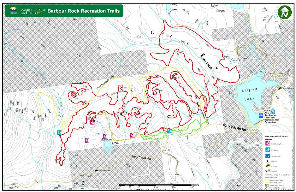
3 Barbour Rock Recreation Trails Plan Columbia Valley Greenways Trails Alliance and Columbia Valley Cycling Society The Columbia Valley Greenways Trail Alliance (Greenways Trail Alliance) and the Columbia Valley Cycling Society (CVCS) are proposing to develop a sanctioned epic mountain bike trail system with approximately 30 to 40 km of trails. The trails are proposed to be located completely on Crown land in the well-known Barbour Rock area of the Columbia Valley approximately 7 km from the District of Invermere on the north side of Toby Creek Road (see Appendix A : Location Map). The trail system is made up of three distinct components: the Green trail; the signature Barbour Rock trail; and, the hiking-only trails. The Green trail is proposed as a wide, family friendly multi-use trail. This trail is laid out as a figure eight loop staying close to the Toby Creek Road. One side of the figure eight heads west towards the base of Barbour Rock, while the other side heads east towards Bear Mountain Forest Service Road (FSR). The signature Barbour Rock trail, shown as red on the Proposed Barbour Rock Recreation trail map (Appendix B), is made up of two distinct loops separated by Bear Mountain FSR. This trail is designed as single track mountain bike trail with varying levels of difficulty from the less experienced intermediate to very experienced intermediate or Blue level rider with some expert sections of the trail with easier ridearounds to by-pass these areas. The hiking-only trails are shown as brown on the proposed trail map (Appendix B ) extending from the west limit of the Green multi-use trail. These trails offer opportunities to reach the summit of Barbour Rock ridge passing the climbing crags on the way. The proposed Barbour Rock Recreation trail system will add to the existing inventory of recreational trails in the Columbia Valley. The Barbour Rock Recreation trails may reduce the number of users on the existing Lake Lillian Trail system, which is just down the road, reducing future trail impact and increasing trail user enjoyment on these Lake Lillian Recreation trails. The Barbour Rock Recreation trail system will be designed and constructed as sustainable trails using the Recreation Sites and Trails BC (RSTBC) Operational Policy for Authorizing Mountain Bike Trail Development standards. Using these standards will ensure the trails are safe; will protect sensitive areas; reduce damage to the surrounding natural environment; and include all the necessary components to make the trail a fun and exciting mountain bike ride. FIGURE 1: VIEW FROM BARBOUR ROCK SUMMIT OVERLOOKING COLUMBIA VALLEY 3
4 4
5 Table of Contents 1. Background... 7 History of Barbour Rock and Surrounding Area... 7 Columbia Valley Greenways Trail Alliance... 8 Columbia Valley Cycling Society... 8 Trail Partners Trail Planning Overview Trends Recreational Trail Benefits Trail Considerations Multiple Trail User Groups Adjacent Landowners/Stakeholders Environmental Protection Trail Design Trail Standards Trail Alignment User Considerations Parking / Trailheads Signage Trail Construction Maintenance Proposed Budget Future Intentions for Trails in the Area Conclusion
6 References APPENDIX A : Barbour Rock Recreation Trail System Location Map APPENDIX B : Barbour Rock Recreation Trail System Proposed Trail Map APPENDIX C : Barbour Rock Recreation Trail System Stakeholder Comments Letter of Support APPENDIX D : VAST Resource Solutions - Vegetation Assessment and Recommendations for Proposed Barbour Trails April The Columbia Valley Greenways Trail Alliance (Greenways Trail Alliance) envisions the region between Canal Flats and Donald, BC as connected by land and water greenways. CVCS - Dedicated to growing the sport of cycling for the health and wealth of our community through a sustainable trail network and respect of public and private land. 6

7 1. Background Trails for recreational use can be found all over the Columbia Valley, the Province of BC and across the country. Recreational trails are very popular as they offer fitness and outdoor recreation opportunities to people of all ages, abilities and socio-economic status. Sanctioned recreation trails often managed by volunteer organizations, as opposed to informal unauthorized trails not maintained at all, provide many benefits to the communities surrounding the trails. Some of the more, well documented, benefits include: tourism opportunities; protection of the environment; and better control and management of the trail and trail users. In BC in 2010 there were approximately 41,821 km of managed trails throughout the province, of which approximately 2,260 km were specifically designed and approved for mountain biking and 3,995 km for the shared use of walking/biking (Norman, 2010). These statistics provide positive support in demonstrating how popular recreation trails and mountain bike trails are. There is also evidence of increased numbers of local and visiting mountain bikers in the Columbia Valley. Every year hundreds of mountain bikers of all ability levels as well as other non-motorized trail users can be found enjoying the sanctioned Lake Lillian trail system as is evidenced from the trail counts collected by RSTBC on the Lake Lillian Trail System during from the summer of 2013 to end of season These counts show weekly trail users during this time period averaging 250 to 550 (Recreation Sites and Trails BC). These totals include all users on the trail unintended trigger by wildlife through the counter. The Kloosifier trail (a popular trail in the Lake Lillian Recreation Trail system) had a counter located on it and the totals showed significant increase of use over the time period of the survey. It is anticipated that winter trail traffic will also increase as fat tire bikes and cross country skiers hit the trail using the tracks set by the Toby Creek Nordic Club. History of Barbour Rock and Surrounding Area Barbour Rock is named after the John Smith Barbour family who owned a ranch in the area in the early part of the 1900 s and stayed there until sometime in the 1950 s (Weller, 2013). The rocky outcrops of Barbour Rock have been accessed by climbers for many years as the crags are challenging, close to Invermere and offer early season snow free climbs. The Crown land that the proposed trail system covers has seen extensive human use and impact over the years. The area has been logged several times, used as cattle range, harvested for Christmas trees, home to trap lines and hunting, used by ATVs, hiking and many other human activities. The area of this proposal is surrounded on three side by private land parcels; to the north, to the east and to the south. The Toby Creek Road runs along the south side and Bear Mountain FSR runs through the middles of the subject area. Two major BC Hydro power transmission line rights of ways also crisscross the crown land of this proposal. (See Appendix A Location Map) It should be noted that the proposed Barbour Rock Recreation trail system is only one of several permitted and approved uses and activities on the subject area. The Crown Tenures covering the area include the following commercial uses/operators: FIGURE 2: BARBOUR ROCK CRAG 7
8 Cattle Range; Trap line; Forest harvesting, including Christmas Tree harvesting (Perry Horning); Electric Power Lines (as mentioned previously); and Private use of Bear Mountain FSR (Seels and Barry Brown-John). The most common recreational use in the area actively occuring is recreational ATV riders who enjoy using the wide old logging roads that crisscross the land. Columbia Valley Greenways Trail Alliance The Columbia Valley Greenways Trail Alliance (Greenways Trail Alliance) is a multi-stakeholder group of individuals and member organizations working together to create a world-class network of interconnected multi-use recreational trails and green spaces throughout the Columbia Valley from Canal Flats to Donald. Greenways Trail Alliance work is focused on collaborative efforts between various groups to achieve access to natural spaces for recreation, education and a thriving community. All Greenways Trail Alliance activities are done with the idea that respect for the environment increases when groups plan, build and maintain trail systems together. Columbia Valley Cycling Society The Columbia Valley Cycling Society (CVCS) is a volunteer organization based in the Columbia Valley and is made up of mountain bike enthusiasts. CVCS s vision is to grow the sport of cycling for the health and wealth of the Columbia Valley communities through sustainable trail networks that have been built and maintained to respect the land and those around it. The Society s primary mission is to enjoy and promote mountain biking opportunities in the valley by developing and maintaining a network of legal, non-motorized trails. Currently the CVCS is fulfilling its mandate by maintaining and managing 60 km of trails; including the Mt. Swansea Trail Network and the Lake Lillian Trail system; all RSTBC sanctioned mountain bike trails on Crown Land. CVCS is a proud member of the Greenways Trail Alliance and strongly believes that the development and maintenance of new multi-use recreational trails, like the proposed Barbour Rock Trail System will help the Greenways Trail Alliance meet their goals and vision. Trail Partners Greenways Trail Alliance and CVCS s prime partner in the proposed Barbour Rock Recreation Trail system is RSTBC, the provincial ministry responsible for recreation sites and trails. Although the trails and surrounding lands are and remain under the jurisdiction of the Provincial Government (RSTBC), the management and maintenance of the proposed trails will lie with the Greenways Trail Alliance and the CVCS. The assistance and guidance of the RSTBC throughout the preliminary trail planning process has been indispensable and will ensure a trail system that the Columbia Valley will be proud of. The Summit Trail Makers Society is made up of a group of hikers whose mission is to promote safe and sustainable hiking experiences by assisting in the development and maintenance of back country hiking trails in the Columbia Valley region. During the development of the Barbour Rock Recreation Trail system the Summit Trail Makers will provide valuable input on the design, alignment and construction of 8

9 the hiking only trails. It is anticipated that the Summit Trail Makers will assume maintenance responsibility of the hiking only trails in the future. Future trail partners of the Barbour Rock Recreation trail system could include the Toby Creek Nordic Society, if interest is expressed for cross country ski track setting on the Green Loop trail. FIGURE 3: EXAMPLE OF AN EXISTING RECREATION TRAIL 9
10 2. Trail Planning Overview Good trail planning, construction and maintenance of the proposed Barbour Rock Recreation Trail system will ensure the trails will become an asset not only to the trail users, Greenways Trail Alliance/CVCS and trail partners, but all of the Columbia Valley as well. Trends Recreational trends show that people are moving away from organized sports and recreation towards unstructured activities such as hiking, biking (both road and mountain biking) and cross-country skiing. These few activities require recreational trails, such as the proposed Barbour Rock Recreation trail system. The BC Recreation & Parks Association (BCRPA) has determined that trends in recreational activities across the province indicate there will be a general increase in the usage of recreational trails and other natural outdoor spaces due to their low user cost and flexible use (BCRPA, 2006). The Barbour Rock Recreation trail system proposes to expand the recreational trail opportunities for Columbia Valley locals and visitors alike. Recreational Trail Benefits Numerous studies throughout Canada and the United States, have been undertaken on the benefits of recreational trails providing well-documented and quantified conclusions. The most important of which is that trails provide easy access for a broad spectrum of people at a very low initial cost and minimal, if any, cost as users later on. Trail users themselves personally benefit when using the trails in terms of meeting their daily physical activity needs for a healthy lifestyle. The BC Select Standing Committee on Health has confirmed that the benefits from an active lifestyle from using recreation trails for instance, include living longer, staying in the workplace longer, and contributing to a generally healthier population (BCRPA, 2006). All positive benefits to the community close by the recreation trail. By knowing that being outdoors has a positive impact on healthy living, the provision of recreational trails in the Columbia Valley allows locals and visitors to pursue healthy living choices and activities while enjoying the benefits associated as a result of a healthy lifestyle. Other significant and well-documented recreational trail benefits include the economic ones. Spending by locals and visitors on trail-related activities help support recreation orientated businesses and other local service related businesses that are patronized by trail users. A trail network can be a key part of a broader tourist destination marketing strategy as it contributes to the image of a healthy, active and vibrant community. A high quality trail network can also attract high profile events such as mountain bike races or cross-country running events. The Barbour Rock and Lake Lillian Recreation trail systems have the potential to become a major tourist attraction to the Columbia Valley. A recent study by Tourism BC and a number of partners found that the majority of BC mountain bikers (both cross country and downhill riders) share a common profile. They are generally male, between the ages of 18 to 44, fully employed and approximately two-thirds of them have a post-secondary diploma or a University degree (Destination BC Corp., 2013). These trail users are known to spend their money at local bike shops, at local food and beverage businesses and at various types of accommodations providers. The study also noted that the majority of visiting mountain bike trail users to BC were from the USA (Figure 4: BC Tourism Mountain Biking Statistics). These visitors primarily went to well-known BC mountain bike spots, such as: Whistler, Rossland and Golden. With the development of the Barbour Rock Recreation 10
11 trail system, along with the existing Lake Lillian Recreation trail system, USA mountain bike visitors may look to the Columbia Valley for mountain bike adventure opportunities thereby bringing additional desirable economic benefits to the area. Statistics on Mountain Bike Travelers from the US to BC Approximately 305,000 mountain biking tourists travelled to British Columbia from the U.S. representing 6% of the pleasure travel population Mountain bikers are three time more likely to travel to British Columbia because of its reputation as a world class reputation for mountain biking BC has attracted 12.8% of the US mountain biking market Significant population of mountain bikers live in the Pacific states: Washington, Oregon, and California FIGURE 4: BC TOURISM MOUNTAIN BIKING STATISTICS Tourism BC conducted Mountain Bike Visitor surveys in both Golden and Rossland in 2011 to determine if and what the economic impact of the significant mountain bike trails development was in these areas. The conclusion was that the mountain bikers surveyed in Golden, who were both locals and visitors, spent approximately $930,000 in the community, while the mountain bikers surveyed in Rossland spent approximately $589,000. These expenditures varied from gasoline to accommodation and from food & beverage to general shopping (Destination BC Corp., 2013). Studies in Whistler, Squamish, and even Williams Lake (Northern BC Bike Tourism) show similar positive economic benefits to the local economies. The addition of trail systems like the Barbour Rock Recreation trail could offer opportunities for similar economic benefits to be seen in the Columbia Valley. Mountain biking and mountain biking travel is growing and is a significant activity. Mountain biking tourism is a significant contributor to local economies, but tourists don't come to places unless there are unquantifiable things such as a strong local bike culture steeped in trail building and advocacy volunteerism and a healthy trail system. (Lau, 2014) The Greenways Trail Alliance and CVCS are working together to build healthy trail systems and grow a supportive trail culture in the Columbia Valley. The benefit to the environment from recreation trails lies mainly by sanctioning the trails thereby removing unauthorized trails. By managing and regulating trail use there is a noted reduction in negative impact to the natural environment in and around the trail. Trail users are provided directions and maps which encourage them to stay on the trail keeping the wear on the trails and away from the surrounding area. Unauthorized trail construction is reduced when sanctioned when maintained trails are in the area as trail users usually take the easy and convenient choice of trails. Sanctioned and authorized trails are well planned to direct trail users away from sensitive area thereby protecting these fragile areas. 11
12 3. Trail Considerations Recreational trails, once developed become a use on our land base. In this respect, recreation trails compete with many other land uses. In the Barbour Rock area the proposed recreation trail will have to consider other recreation activities, such as existing recreational motorized ATV use, along with the current Crown Tenure activities (as listed earlier in the History of Barbour Rock and surrounding area) already occurring in the area. This is not an unusual situation as in all of BC and Canada every square metre of land has already been allocated for some purpose, and administered by some government agency (TrailNet, 2001) making recreation trails just one of many uses on the land.. Good trail design considers all of these activities and uses in the planning process to determine if the proposed recreational trails are either compatible with the existing use or not and therefore appropriate in the area of the proposal. The Barbour Rock Recreation Trail Plan has considered the impact of and on all of these other activities in determining if the proposed trail will fit with all of the other uses of the Crown land. Greenways Trail Alliance and CVCS has determined that the proposed recreation trail system can be designed and constructed to complement the existing uses, by minimizing any interference with the other land uses on the Crown land. Multiple Trail User Groups Although the Barbour Rock Recreation trail system will be designed and constructed with mountain biking in mind all non-motorized users are welcome to share the trail. The anticipated other trail user groups could be climbers, hikers, runners and possibly cross-country skiers and snowshoers in the winter. At present climbers using the Barbour crags either park in an unofficial area on the south side of Toby Creek Road or from an old logging road at the end of Bear Mountain FSR on the north side of the crags. Access from the south to the crags is popular as the walking distance to the crags is a fairly short trail. The back or north parking area sees limited use as it can only be accessed with high clearance vehicles. The proposed Barbour Rock Recreation trail system does not take away either parking area or the ability of the climbers to access the crags. The development of the trail system simply will provide a sanctioned trail to the crags for the climbers to use. The Summit Trail Makers have pointed out the benefit of having authorized and managed trails in the area for hikers as they will be close to Invermere and open and snow free earlier in the year than the alpine trails in the Columbia Valley. The Summit Trail Makers initially expressed interest in having opportunities to summit the ridges thus influencing the location and alignment of the hiking only trails proposed. With the number of possible different trail users groups that could use the Barbour Rock Recreation trail system conflict between the users may occur and must be considered in the trail design and construction. Proactive measures are proposed in order to avoid or reduce any conflict on the Barbour Rock Recreation trails. These may include such measures as educating all trail users on trail etiquette by working with the Greenways Trail Alliance and CVCS memberships. Another measure may include adding information on trailhead signs to ensure that all users feel comfortable on the trails. Standard trail etiquette for recreation trails is shown below in Figure 5: Standard Trail Ettiquette. 12
 will continue to occur on lands adjacent to the trails as permitted by the Province. Trail Etiquette Keep right. Move off the trail wherever possible for less mobile trail users.")
13 Although the Barbaour Rock Recreation trails themselves will be identified as non-motorized use only, trail users will be made aware that motorized recreational activities (ATV and motorcross for example) will continue to occur on lands adjacent to the trails as permitted by the Province. Trail Etiquette Keep right. Move off the trail wherever possible for less mobile trail users. Stay on the trail don t short cut. Hikers, runners and bikers should always yield to horses. Bikers should yield to hikers and runners Downhill traffic should yield to uphill traffic. When approaching others from behind, a friendly greeting does wonders to let others know you are coming and common courtesy will always go a long way! Don t litter. FIGURE 5: STANDARD TRAIL ETIQUETTE Adjacent Landowners/Stakeholders As with any development project that impacts the land, it is important to involve the community and affected stakeholders throughout the project. Conversations at the beginning of the project help to identify concerns and avoid problems later on. CVCS members have taken a very proactive approach to community consultation for the Barbour Rock Recreation trail development by actively connecting with adjacent land owners, other user groups, and various stakeholders including the Crown tenure holders. To date excellent feedback has been received from the all of the contacted individuals, organizations and stakeholders. Comments have not all been positive about the proposed trail system or mountain biking in general, but all are constructive and useful resulting in several changes to the initial trail concept and have provided a clear understanding of many of the concerns, issues and stakeholder operations requirements. A summary of the feedback received from the contacted adjacent landowners and stakeholders along with Greenways Trail Alliance/CVCS responses are listed in the Appendix C. Greenways Trail Alliance and CVCS welcome all input and suggestions on the proposed Barbour Rock Recreation trails so as to ensure the best trails possible that will not only offer an epic mountain bike ride but one that respects the land, adjacent land owners, stakeholders and Crown tenure operators. The proposed trail development of the Barbour Rock area will become an integral component of the Trails Master Plan currently underway by the Columbia Valley Greenways Trail Alliance. 13
14 To date two other recreation organizations have expressed interest and support for the proposed trail development: The Climbers Access Society of BC indicated they are supportive of the proposed plan as long as there is continued access to the crags ( attached); and, The Summit Trail Makers Society (STMS) supported the proposal as it provides a recreation area close to town and close to a paved road, which is a huge benefit as the trails would be available earlier in the season than the trails in the alpine. Great for users who only want to spend a couple of hours (See Letter of Support in Appendix C ). Environmental Protection When planning and designing recreational trails there must be a balance between the desire to create a place for recreation and the need to protect the environment. A goal of recreational trail building, including mountain bike trails is to ensure a long-term relationship between the human users and the surrounding natural environment by building a sustainable trail. A sustainable trail is one that is not only easy to maintain but one that becomes a part of the landscape by minimizing the environmental impacts (Richards, 2007). As shown in the Figure 6: Definition of a Sustainable Trail, the US National Park Service developed an excellent definition of sustainable trails which the proposed Barbour Rock Recreation trail system will use in planning, design and maintenance of the trails. Using this definition as the base line for trail development is important as maintenance costs for poorly designed and built trails are extremely high reducing their value to a volunteer based organizations such as Greenways Trail Alliance and CVCS. Poorly built trails that adversely impact the environment deteriorate over time causing damaging to the environment and take away from the users enjoyment. An objective of the Barbour Rock Recreation trail system is to work with the terrain and the existing features in order to reduce the need for significant alterations to the natural terrain and future expensive maintenance activities. During the community consultation process concerns were raised about the environmental impact of building a recreational trail in this area. As a result, a Registered Biologist was engaged to look at the area around the proposed trail, do an assessment of the potential impacts and come up with any mitigation measures or Sustainable Trails Definition: Supports current and future use with minimal impact to the area s natural systems. Produces negligible soil loss or movement while allowing vegetation to inhabit the area. Recognizes that pruning or removal of certain plants may be necessary for proper trail construction and maintenance. Does not adversely affect the area s wildlife. Accommodates existing use while allowing only appropriate future use. Requires little rerouting and minimal trail maintenance. -- From the National Park Service, Rocky Mountain Region, January 1991 (Richards, 2007) FIGURE 6: DEFINITION OF A SUSTAINABLE TRAIL recommendations on how the trail construction could be done in a low impact manner. VAST Resource Solutions of Cranbrook undertook the project and provided a plant species and plant community assessment overview; identified possible areas of concern; and, came up with a number of recommendations for trail construction to reduce the actual and potential impact of the trail during construction. VAST also considered the impact of trail development on badger habitat and provided some recommendations to mitigate possible conflicts. 14
15 Environmental Trail Construction Recommendations A summary of VASTs recommendations for the design and construction of the proposed Barbour Rock Recreation trail system include the following: Red-listed Species and Ecological Communities at Risk Recommendations In order to avoid disturbing Red-listed plant species that could occur in the area, VAST recommends that a copy of the Red-listed plant list be on-site during all trail construction. Use of phones for taking a picture of the plant and sending it to a plant ecologist for identification is suggested; If a Red-listed plant is found a GPS location should be taken and a plant ecologist notified so confirmation can occur. Trail construction work does not have to stop if it will completely avoid the possible Red-listed plant species; If it appears that the trail may impact a Red-listed plant then the trail should be re-aligned to go around it without disturbing it in any way; and, If the Red-listed plant species should happen to cover a large area where the trail cannot be rerouted to avoid it, a trained plant ecologist consultant should be engaged. This consultant can positively identify the species and instruct the trail building crew on the appropriate measures required to prevent or mitigate any disturbance. Riparian Habitat Recommendations Reconsider the section of the Green trail along the west side of Lake Lillian as the mitigation measures needed are extensive (VAST Riparian Area 1); Re-use of the existing cycle bridge foundation when the bridge surface is widened is recommended at the VAST Riparian Area 2 (in Vast report). There should be no further disturbance to the riparian zone vegetation (no trimming or removal of shrubs and vegetation) or disturbance to the creek bed; A boardwalk structure is suggested in order to cross the braided stream at the creek crossing identified as VAST Riparian Area 3 (in Vast report). This should be located upstream of the old logging road to avoid further destabilization of the banks; Only hand tools should be used to install the boardwalk posts at VAST Riparian Area 3 (in Vast report); No grubbing or vegetation removal should occur along the banks of the channels at VAST Riparian Area 3 (in Vast report) and the trail location should be chosen to minimize the amount of clearing required while traversing this riparian zone; and, No disturbances to birds nests during the nesting window of mid-march to mid-august are permitted. A bird nest search prior to any clearing must occur if activity during this period. Grassland Area Requirements Wildlife trees should be noted and avoided by a minimum of 1.5 times the height of the tree; Trail construction crews should watch for Red-listed plant species; and, Ground disturbance should be kept to a minimum and shrub clumps should be avoided. Rocky Section Requirements Watch for Red-listed plant species and wildlife trees and use the same recommendations as shown above. Wildlife Requirements Trail construction crews should watch for burrows from badgers and avoid by routed the trail away from them; 15

16 All badger and burrow sightings should be reported to the BC Ministry of Forests, Lands and Natural Resource Operations; In the unlikely event an active maternal den is encountered, all trail work in the area should cease immediately until the badgers have moved on. The complete assessment by VAST Resource Solutions is attached as Appendix D to this trail plan. There are known times of the year in which use on parts of the trail system or the entire network is discouraged in order to protect the environment. These could include times of the year in which wildlife is present, has certain nesting or mating needs or the soils are in a fragile state and any use is damaging such as when there is considerable mud. Signage and education will be used to manage trail use during these times. FIGURE 7: DOUGLAS FIR, A COMMON TREE IN THE BARBOUR ROCK AREA 16
17 4. Trail Design The design and construction of a trail greatly impacts the long-term success and maintenance requirements of a trail. To date hundreds of hours have been put into planning the proposed Barbour Rock Recreation trail system in an effort to create a well-crafted, unobtrusive, environmentally sensitive trail system that will be fun and exciting to ride. Trail Standards By using trail construction best practices and the RSTBC mountain bike trail standards in designing, building and maintaining the Barbour Rock Recreation trail system a safe, enjoyable mountain bike trail will be built that protects the surrounding environment and respects the adjacent landowners and other stakeholders interests. The RSTBC standards detail trail width, trail surfaces, grade and drainage. The RSTBC standards also incorporate a Trail Type system which categorizes trails based on tread characteristics. These trail types range from I to V with Type I, having the highest amount of use and the most impact on the environment; and Type V, which encourages the least amount of traffic by using minimal tread width and therefore having the least impact on the environment. TABLE 1: TRAIL TYPE CHARACTERISTICS Trail Type Characteristics Type I - A paved double-track trail for smooth, all weather use to provide access to communities or parks - Trail surface is asphalt or chip-seal coat - Clear trail width of m plus 0.6m gravel shoulder with adequate drainage infrastructure - Clear trail height of 3.0m - May include illumination for night use - May include interpretive sites, benches and viewing areas Type II - Either a double-track or single track trail - Usually machine built - Smooth with all embedded obstacles removed - Surfaced with crushed limestone with fines, well-compacted gravel or existing old road bed - Clear trail width of up to 5.0m for double-track with om tread width and 1.6m clear trail width for single track with 1.0m for tread width - Clear height of 2.4m - Possible illumination for night use Type III - An unsurfaced single track trail - Clear trail width of 1.1 to 1.3m with approximately cm as tread width - Clear trail height of 2.4m Type IV - An unsurfaced single track trail - Clear trail width of 1.0m with approximately cm as tread width on native soil including some rough terrain - Clear trail height of 2.4m Type V - A low-impact natural trail or lightly used wilderness trail - No high impact users such as motorized or horses - Provide 30 50cm of tread width maximum; avoid tread grubbing, could include sections of very rough terrain - Clear height of 2.4m - When crossing sensitive areas use boardwalks 17
18 Rating trail difficulty is very subjective and usually based on a number of variables, including the fitness and attitude of the trail user. Trails for mountain biking are rated using trail descriptions, grade, distance and the number of Technical Trail Features (TTF). Generally, the user difficulty level also increases with the trail Type; Beginner or Green level trail = Type I to II, to an Expert or Black level trail = Type V. MOUNTAIN BIKE TRAIL RATING DESIGNATIONS APPROPRIATE USER TRAIL DESCRIPTION GREEN CIRCLE (Easy) Beginners and Recreational Riders, Mountain Bikes recommended. Safety equipment required (including helmets) Gentle slopes and easily avoidable obstacles such as rocks, roots and potholes. BLUE SQUARE (More Difficult Intermediate Riders. Mountain Bikes required. Increased challenges and difficulty. Full safety equipment required. Challenging riding with steep slopes and/or obstacles, narrower trails with reduced traction. Required riding experience. BLACK DIAMOND (Most Difficult) Advanced/Expert Riders. Difficult and technical challenges. Full safety equipment required. High level of fitness required. Mixture of long steep climbs and descents, loose trail surfaces, numerous difficult obstacles to avoid or jump over, drop-offs and sharp corners. Some sections easier to walk than ride. DOUBLE BLACK DIAMOND (Expert Unlimited) Expert Riders Only. Most difficult and technical challenges. Highest risk level. Full safety equipment required. Do not bike alone. Recommend carrying a cell phone with you. Exceptional bike control skills and balance essential to clear many challenging obstacles. Higher risk level. Only a handful of riders will enjoy these rides. Some sections easier to walk than rider. TYPICAL TRAIL TYPE II III III IV III - V III - V FEATURES Embedded trail obstacles up to 10 cm high. Embedded trail obstacles up to 20 cm high. Embedded trail obstacles may exceed 20 cm high. Embedded trail obstacles may exceed 20 cm high. MINIMUM WIDTH 1.0m 0.5m 0.3m 0.3m or less TRAIL SURFACES Primarily soil and small loose rock, occasional Rough natural terrain and increased rock and root Rugged natural terrain. See TFFs below. Rugged natural terrain. See TFFs below. screening. debris. TFFs (see below) AVERAGE GRADE 8% 10% 15% May exceed 15% MAXIMUM GRADE MINIMUM CURVE RADIUS EXPOSED NATURAL OBSTABLES (MAX. HEIGHT) BRIDGES (MIN. WIDTH) TECHNICAL TRAIL FEATURES (TTFs) ROCK FACE OR RAMP DESCENTS (MAX. ANGLE) DROPS (MAX.HEIGHT) JUMPS (MAX. HEIGHT) 15%, except rock faces at 25% Climbing 25%, Descending - 35%, Rock Surface -45% Climbing 35% May exceed 35% 2.4m 1.8m Sharp corners Sharp corners 10cm max. height. Occasionally higher height for highly visible, easily avoidable obstacles. Min 1.0m Small roots and logs to cross, embedded rocks to avoid. Rock face descents not to exceed 25% grade. None None 20cm max. height Min. width of 50cm. Flat decking is minimum onehalf the height above surface. TFF width to height ratio of 1:2. Small bridges (flat, wide, low and rollable from section to section). Small rollable drops. Small teetertotters, less than 60cm high. Small jumps. Medium sized logs. Various heights, some exceeding 20cm Various widths. Min. 30cm. Flat width of decking is onequarter the height above surface. Elevated bridges less than 3.0m high above surface. TFF width to height ratio of 1:4. Elevated bridges and teetertotters with max. deck height. Connected bridges. Larger jumps. Steep descents with sharp transitions. Various heights, some exceeding 20cm Most difficult, exceeds Black Diamond. Most difficult. Exceeds Black Diamond TFFs. 45% Not to exceed 120%. May exceed 120% Drops up to 30cm, with exit cleared of all obstacles. 45cm no jumps with consequences for lack of speed. Table tops jumps max. 40cm high. Drops greater than 30cm. Some mandatory air. Table tops, no maximum height. No gap jumps. Mandatory air. Same, except may include gap jumps. 18

19 TTFs are obstacles on the trail designed to add a degree of difficulty in order to challenge the skill of the mountain bike rider. These TTFs can either be natural (e.g. rock face) or man-made (e.g. jump ramp). A bridge or other feature that is constructed on the trail in order to enhance trail safety, access or protect the environment such as a bridge or boardwalk, is not considered a TTF. (RSTBC, 2013) The Barbour Rock Recreation trail system is proposing to include trail sections which range from Type I and Type III trails. Trail Alignment The final alignment and location of each portion of the Barbour Rock Recreation trail system will ultimately be set during the construction stage as the terrain will dictate the final trail alignment and location. This may result in a slightly different alignment than what is shown on the proposed trail map (Appendix B ). The trail alignment will be set to take advantage of existing roads and trails and open lines of vegetation. Soil conditions will also be considered along with other environmental sensitivities in the trail alignment position. As mountain bikers are known to enjoy narrow trails that wind and flow with the terrain long straight stretches will be avoided. Straight downhill runs will be also avoided as they can result in drainage problems and trail degradation, instead special trail building techniques will be employed to encourage controlled downhill speeds. These may include adding small uphill turns at the bottom of a downhill section or the use of berms around corners to reduce or lessen skidding which degrades the trail. The Green trail is approximately 3 to 4 km long staying close to the Toby Creek Road in a figure eight configuration. The Green trail will be designed as a multi-use Type II standard trail with grades kept as low as possible averaging at 15% and having a trail tread width of approximately 1.0m wide. This will encourage a variety of abilities and non-motorized trail uses moving in two directions on the trail. The Green Trail will be the focal point of the Barbour Rock Recreation trail system and all other trails sections will connect directly to or loop back onto it with the main trailhead being located at the intersection of the figure eight. The east loop of the signature Barbour Rock trail (the east side of Bear Mountain FSR) is approximately 10 km of the 30 km plus complete trail. The trail begins at the eastern limit of the Green trail and is made up of undulating intermediate (Blue) level mountain bike terrain. The trail starts out by following an existing single track trail passing close to the north end of Lake Lillian and crossing Neave creek twice. One crossing will use an existing small bridge structure that was built for a previous international mountain bike race while the second crossing will require a new bridge structure to be built. The new structure construction will follow the standards and the requirements of RSTBC to ensure user safety as well as minimize impact on the environment. The final design and length will depend on the exact location of the crossing which will be determined in the field using VAST s recommendation to keep the crossing well away from the wildlife watering hole and not in an area that will damage the creek banks (VAST Resource Solutions, 2016). After crossing Neave Creek for the second time the trail will loop back to the Green trail by meandering through the forest with twists and turns and uphill s and down. This trail will be built primarily as Type II or III standard depending on the section and 19
 is proposed as a single track trail providing")
20 terrain. The ability difficulty will be similar to that of the Johnson trail in the Lake Lillian trail system, blue (intermediate) level riders. FIGURE 8: SECOND NEAVE CREEK POTENTIAL CROSSING LOCATION The longer, showcase west loop of the Barbour Rock trail (west side of Bear Mountain FSR) is proposed as a single track trail providing opportunities to summit one or all of the five peaks on the ridges of Barbour Rock. This trail loop can be ridden as one long ride or broken up into shorter rides by using connections back onto the Green trail or Bear Mountain FSR. Riders will come upon a number of long uphill climbs and curvy downs. Breath-taking views of the Columbia Valley are the reward for those trail users who reach the summits and stop to take it all in. The trail is intended to be ridden in both directions, although one way may become more desirable then the other. The trail will be built as a Type II or Type IV standard trail and will be appropriate for the more experienced blue (intermediate) level riders as there may be some black or expert level sections on the trail. The hiking-only trails near Barbour Rock will branch s off at the western extent of the Green trail near the Barbour Rock crag. These narrow winding hiking trails will enable hikers to summit the highest ridge from the front side of Barbour Rock. The trail will be designed to follow the terrain and be approximately 2 to 3 km in length. During the initial Barbour Rock Recreation trail planning, some consideration was given to developing a boardwalk trail along the west shoreline of Lake Lillian as a link to the Lake Lillian Recreation Trail system. Unfortunately, the environmental considerations were such that the CVCS felt it was outside their ability or interest to undertake this challenge. It was therefore removed from the proposal. Currently, no link is proposed between the two trail systems at this time. User Considerations The CVCS hopes to provide exciting experiences for all levels of riders from families to advanced riders in the Barbour Rock Recreation trail system. Although mountain bike riders may not feel 100% comfortable on all sections of the trail system and may find themselves walking, each trail has been proposed to offer challenging experiences for some, excitement for all and beautiful views all around. 20

21 As with all recreational trails there can be safety concerns and the activities of mountain biking, climbing or hiking can be dangerous, the Barbour Rock Recreation trail system and the proposed uses will be no different. The trails will be designed and constructed so as to not put any user into an extremely dangerous situation that can be avoided. In the rare instance where the trail must go close to a potential dangerous spot, signage or barriers will be placed to warn trail users. In the unfortunate event of an accident, the Barbour Rock Recreation trail system is in the enviable position of having public road access on all sides of the trails which can be used by emergency vehicles for assistance or extraction. The looping design of the trail brings it close to the roads in several locations offering outs every few kilometers. The trail system is also completely within cell range if help is needed. FIGURE 9: VIEW FROM SUMMIT TOWARDS PANORAMA Parking / Trailheads Trailheads are necessary to provide a base or staging area for the trail. The Barbour Rock Recreation trail system layout has been designed with well-defined trailheads to give all users trail orientation and organization. There are two parking areas / trailheads, shown as on the proposed trail map (Appendix B ), proposed for the Barbour Rock Recreation trail system. The primary or biggest parking area is positioned close to Toby Creek Road with space for approximately 20 vehicles. This trailhead will be the key starting point for all the trails. The secondary parking area / trailhead is proposed to be smaller in size providing parking spaces for only 4 to 6 vehicles each. Each trailhead area will include a parking area, a trail map, outhouse facilities, and possibly picnic tables similar to other RSTBC Sites in the area. The trailhead kiosk will include space for notices to educate or notify users of special events or circumstances. This information could include the following: Trail use rules and etiquette of trail use; such as, keeping all dogs under control or recognizing there will be multi-users groups on the trail. Information on requirements of the Crown tenure holders (You are in an active Christmas Tree Harvesting area). Emergency contact information (911). Contact information for trail maintenance concerns (CVCS). Acceptable trail user groups (non-motorized on trails only). Or a bulletin board. 21

22 FIGURE 10: LAKE LILLIAN RECREATION TRAILS PARKING AREA Signage RSTBC (BC Ministry of Forests Lands and Natural Resource Operations) has standards and guidelines for all signage on sanctioned recreation trails. These standards set the type, size and style of signs. All of the signs proposed for the Barbour Rock Recreation trail system aim to enhance the users experience, protect the environment and rights of other Crown tenure holders (BC Ministry of Forests Lands and Natural Resource Operations, p. App 6). The challenge in planning for sign is to find the balance between the number of signs needed for effective trail use, with having too many so that they interfere with the natural setting creating a negative viewscape from the trail. If too few signs are installed, trail users have problems direction finding, there may be safety concerns and user conflicts. The intention for signage on the Barbour Rock Recreational trails is to continue using the very successful direction (Figure 11) and You Are Here (Figure 12) signs currently used on the Lake Lillian Recreation Trails. As can be seen in the examples additional user information is included about the ability level of the trail and a reminder for no motorized vehicles. The direction signs will be installed at every trail intersection with the You are Here signs placed at strategic locations as needed. 22

; and")
 or trail conditions as shown in Figure 13: RSTBC")
23 FIGURE 11: EXAMPLE OF RSTBC DIRECTIONAL SIGNS FIGURE 12: EXAMPLE OF RSTBC YOU ARE HERE TRAIL SIGN Temporary signs may also be used on the trails when necessary to manage trail use in certain situations. An example of when these types of signs would be used could be when it is necessary to caution trail users of dangerous situations; remind users of permitted and not permitted activities on the trail (nonmotorized only); and notifications to the users to changes to the trail system in unusual situations. This could be for wildlife, commercial activities (logging, etc) or trail conditions as shown in Figure 13: RSTBC Example Managing Use Sign. FIGURE 13: RSTBC EXAMPLE MANAGING USE SIGN. 23


24 5. Trail Construction As previously mentioned all construction work on the Barbour Rock Recreation trail system will follow the standards and requirements of RSTBC. In general the trails will be built using trail construction best practices to avoid among other things drainage problems which are the most common reason that trails are damaged. To do this good site preparation is necessary as it will ensure proper grading that directs water movement to flow off the trail in a desired direction. Trail construction on the Barbour Rock Recreation trail system will be a combination of machine work and hand tools. Machine work will take place on the majority of uphill portions of the trails as this ensures proper grading and drainage in areas that would be difficult to accomplish with hand tools. The west Barbour Rock trail loop will be aligned and constructed using existing open lines between the trees so that little to no vegetation need be removed (Figure 13: West Loop Open Forest). This method minimizes any soil disturbance and meets the sustainable trail definition. On any side hill the trail technique will be done so as to minimize any cuts and fills to protect the existing vegetation and optimize natural drainage. When trails are built that disregard the natural terrain and subsequent drainage patterns, trail construction and maintenance costs are higher something the Greenways Alliance and CVCS would like to avoid. A professional trail builder will be brought in to assist the volunteer workers by removing some of the heavy lifting as well as completing the trails in an efficient and timely manner. FIGURE 14: EXAMPLES OF HAND TOOLS USED FOR TRAIL BUILDING AND MAINTENANCE FIGURE 15: WEST LOOP OPEN FOREST 24


25 At this time no TFF s are proposed on any of the trail sections in the Barbour Rock Recreation trail system. In the future if a TFF is installed it will be constructed so as to exceed the RSTBC minimum standards for strength and stability so as to ensure trail user safety. Bridge construction over Neave Creek will follow the standards set by RSTBC to ensure the safety and comfort of trail users. An example of one type of bridge structure that could be built is shown in Figure 16 below similar to the bridge on the Johnson Trail. This bridge surface type includes tightly spaced deck rungs to avoid anyone falling through while allowing drainage of rain water off the bridge structure. A safe and appropriate width of bridge keeps trail users from riding or walking through the creek or into sensitive areas that are trying to be protected. FIGURE 16: BRIDGE CONSTRUCTION SPECIFICATIONS 25


26 6. Maintenance Trail maintenance is an integral component of managing trails. As stewards of the trails the Greenways Trail Alliance, CVCS and all trail users provide an effective level of protection to the environment by simply using the trail. Undesirable activities on and around the trails are discouraged by the very presence of trail users. The trail users will become the eyes and ears of the area noticing any unauthorized activities, such as camping and unattended campfires and offer quicker response time to address these harmful situations. By keeping the Barbour Rock Recreation trail system in as excellent shape as possible the Greenways Trail Alliance and CVCS members and all trail users will continue to enjoy and benefit from the trails now and in the future. Annual trail inspection and maintenance will occur on the Barbour Rock Recreation trail system. Generally trail maintenance will include the list below in Figure 18: Trail Maintenance Activities. Checking for invasive species appearing in and around the trails will also be included in the maintenance activities. Most importantly volunteers will be looking to address any drainage or erosion problems on the trails. As required annual reporting in writing will be provided to RSTBC on trail and TFF inspection activities and results, and any maintenance activities undertaken. A well maintained and cared for trail helps to promote good behaviour among trail users. FIGURE 17: VOLUNTEER TRAIL CREWS AT WORK Trail Maintenance 1. Deadfall Cut out all blowdown/deadfall over the trail, remove wood a minimum of 0.5 metre from the tread centre and dispose downhill when possible. 2. Brushing Remove all juvenile trees and woody brush for 0.5 metre on either side of tread centre within 3 centimetres of ground level. Scatter the cut material out of sight of the trail. 3. Limbing Remove tree limbs to allow 2.5 metres of overhead clearance above the trail, with metres total clearance width. Scatter cut limbs a minimum of 3.0 metres from the trail edge, out of sight where possible. Ensure limbing cuts are clean, without scarring the main trunk of the tree. 4. Tread surface Ensure the tread surface of the trail provides a stable walking surface of not less than 40 centimetres in width. 5. Erosion control Clean and repair any existing water bars, culverts and ditches as necessary to drain water away from the trail and prevent erosion. 6. Route marking Mark obscure routes with cairns or delineating tags as required. 7. Litter cleanup Remove litter and garbage at the trailhead, along the trail, and at any associated camping areas. 8. Trail sign maintenance Conduct minor repairs as required, such as resetting posts and ensure signs are secure. FIGURE 18: EXAMPLE TRAIL MAINTENANCE TASKS 26

27 7. Proposed Budget The proposed budget for the development and construction of the Barbour Rock Recreation trail system is approximately $250,000 to $300,000 made up of volunteer effort, donated materials and equipment as well as purchased items and professional assistance. Approximate Amount Trail Construction $6/lineal m over 30-40km $180,000 - $240,000 Parking Lots/Trailhead $20,000 Signage $10,000 Miscellaneous $30,000 - $40,000 Proposed Total Budget $250,000 - $300,000 Greenways Trail Alliance and the CVCS will raise the money necessary to complete the project through fund raising activities or applying for grants. FIGURE 19: BARBOUR LAKE 27

28 8. Future Intentions for Trails in the Area The Greenways Trail Alliance is currently developing a Trails Master Plan for the Columbia Valley region. The Trails Master Plan is a strategy that will provide the region with a long term community vision for trail-based recreation and establish clear direction on future trail development. A goal of the Greenways Trail Alliance is to link the Columbia Valley from Canal Flats to Donald and all of the communities in between with a trail network for non-motorized forms of transportation. The Barbour Rock Recreation trail system makes up part of the regional trail network of the Master Plan. Potential future trails in the area of the proposed Barbour Rock Recreation trail system include a link with the Lake Lillian trail system just down the Toby Creek Road and one over to Lake Enid. A future link between the District of Invermere, the Lake Lillian and Barbour Rock Recreation trails all the way up to Panorama have been discussed which would include a bridge over the Toby Creek at a location to be determined. 28

29 9. Conclusion The proposed Barbour Rock Recreation trail system will be an epic mountain bike adventure that can be ridden as one long ride or a series of shorter loops. This proposal for a sanctioned authorized trail on Crown land is a positive step towards effective management of recreational use of this area on the Toby Benches. Locals and visiting mountain bike riders and other non-motorized recreational users will be welcome on the trails. The design and construction methods of the trail system will follow RSTBC standards to ensure adequate safety, environmental protection and provide an enjoyable experience for all trail users. The recommendations presented by VAST Resource Solutions will be integrated into all of the trail construction as they highlight the viability and sustainability of the trail system. Greenways Trail Alliance and CVCS have worked diligently to address the issues and concerns expressed and presented through the community and stakeholder consultation. The trails have been located as far away from private lands and environmentally sensitive areas as possible in respect for the adjacent landowners and the environment. The trails will limit soil disturbance where possible using old trail, roads and tracks as well as existing structures to reduce unnecessary construction and impact to the natural environment. Any installation of new structures, signs or access driveways will be done using the sustainable methods. Annual maintenance activities will be done to upgrade any portions of the trail which are being degraded by use which could include realigning the trail to eliminate the problem area. The Greenways Trail Alliance and the CVCS look forward to riding, walking, running or hiking the new Barbour Rock Recreation trail with you soon. 29
30 References BC Ministry of Forests, F. (n.d.). Recreation Manual - Appendix 6: Signs. Province of BC. BCRPA. (2006). Strategic Plan for the Parks and Recreation Sector in BC. BC Recreation and Parks Association. Destination BC Corp. (2013). BC Input-Output Model Report: Mountain Biking in Rossland and Golden. BC Stats. IMBA. (n.d.). Trail Solutions: IMBA s Guide to Building Sweet Single Track. IMBA. Lau, L. (2014, June 7). Economic Impacts of Mountain Biking Tourism. Retrieved from Pinkbike: Norman, T. J. (2010). CANADIAN TRAILS STUDY. National Trails Coalition. Rec Sites & Trails BC. (2001). Chapter 10 - Recreation Trail Management. In L. a. Ministry of Forests, Rec Sites and Trails Manual. Province of BC. Recreation Sites and Trails BC, I. (n.d.). Trail User Counts Johnson and Kloosifier Ministry of Forests, BC. Resort Municipality of Whistler. (2003). Whistler Trail Standards: Environment and Technical Trail Features. Resort Municipality of Whistler. Resort Municipality of Whistler. (2003). Whistler Trail Standards: Environmental and Technical Trail Features, Edition 1. Resort Municipality of Whistler. Richards, B. (2007). Pathways to Trail Building. Tennessee Department of Environment & Conservation. Recreation Educational Services Division Greenways & Trails Program. RSTBC. (2013). Authorizing Recreational Mountain Bike Trails on Crown Land - Operational Policy. BC: Province of BC. TrailNet, A. (2001). TRAIL BUILDER S COMPANION. Alberta Community Development. VAST Resource Solutions. (2016). Vegetation Assessment and Recommendations for Proposed Barbour Trails. VAST Resource Solutions. Weller, A. (2013). Ranches in the Windermere Valley. Windermere Valley Museum and Archives. Whistler Trail Standards: Environmental and Technical Trail Features, Edition 1. (n.d.). Retrieved from htpp:// 30

31 APPENDIX A : Barbour Rock Recreation Trail System Location Map 31
32 APPENDIX B : Barbour Rock Recreation Trail System Proposed Trail Map 32
33 33
34 34
35 APPENDIX C : Barbour Rock Recreation Trail System Stakeholder Comments STAKEHOLDER COMMENT / CONCERN concerns with rogue mountain bike trails that have appeared in the area over the years causing soil degradation CVGTA / CVCS RESPONSE This is the purpose of the Trail Plan and Application for authorization and sanctioning with RSTBC. This will ensure proper design and maintenance so eliminate soil degradation from trail use. concerns with the potential negative impact to the water quality of Barbour Lake which provides domestic drinking water Trail location and alignment has been positioned so as to provide excellent views of Barbour Lake only. concerns with the historic use of old trails and roads by 4 X 4ers, quaders, motorbikes, snowmobilers along the fence line surrounding the property and would like to see this illegible road decommissioned and future access encouraged off the Bear Mountain FSR concerns that the Crown land in the Toby Benches is already ¾ covered with trail tenures and feels that is minimal undeveloped areas just to be happened upon with little or no structure; concerns about other environmental impacts of trail development on fragile soils, open forest and grasslands in this area and feel there are better locations for trail developments in other locations on the Benches the basic concept of that the Barbour Rock Recreation trail system would be a great multi-use area for biking, hiking and rock climbing something the Valley has long needed current Crown tenure holder has concerns that the proposed developments will lead to added risk of fire and theft and may expose the operator to added liability or limitations on activities or future developments; I am in the process of applying for some logging within the Christmas tree permit area. This logging is necessary to develop areas for Christmas tree production. I have two areas identified in my approved Management Plan and it would be logical to complete the harvesting prior to any trail development Trail developments cannot limit my future opportunity or plans for logging or development of roads for Christmas tree operations; Signage at parking areas should clearly identify the risk of fire and identify the area as a managed Christmas tree operation; I need to reserve the rights to utilize all existing trails and roads for vehicle access for the purpose of Christmas tree operations; I am strongly opposed to a parking area on the south side of the Panorama rd. This parking area is on Christmas tree permit C00122; BC Hydro has no objections to the multi-use trail crossing the Right of Ways; The proposed parking area off Bear Mountain Road is too small. If these trails are as well used as I expect there will be spill over which will interfere with Heavy Hauling (industrial Traffic) on Bear Mountain Road; This information has been passed onto RSTBC who will determine which trails and roads will be decommissioned. The Barbour Rock Recreation trails are part of the CVGTA Regional Trails Master Plan which will detail future recreation trails throughout the Columbia Valley Trail location and alignment has been completely removed from the initial alignment along Lake Lillian west shoreline, an environmentally sensitive area CVGTA/CVCS is glad to hear this support of the plan CVGTA / CVCS respects the Crown tenure holder concerns and will work with the trail users to educate them on the other uses in the area. The CVGTA/CVCS will work with RSTBC to establish a communication protocol with the Crown tenure holders to notify trail users of commercial activities in the area of the trails or when trail must be closed as necessary to allow the Tenure activities (e.g. Christmas Treeing) to proceed safely as above CVGTA / CVCS respects the Crown tenure holder concerns and recognizes that any fire in the area would be a detriment to the trails themselves. CVGTA / CVCS respects the Crown tenure holder existing use of the area and has designed the trails so as to work in conjunction with these uses so as to not interfere with the activities. CVGTA/CVCS is working with the MoTI on the location of the primary parking area. This parking area will be located so as to ensure the safety of trail users and regular traffic in the area. CVGTA/CVCS is glad to hear this support of the plan CVGTA/CVCS is working with the MoTI on the location of the primary parking area. This parking area will be located so as to ensure the safety of trail users and regular traffic in the area. 35
36 STAKEHOLDER COMMENT / CONCERN I like your proposed signs but strongly suggest they should clearly state no motorized vehicles (except for maintenance) as sleds, atv s and motor bikes do not mix with bicycles, cross country skiers and such; Don t like the proposed parking lot near chip vans would like to see it moved to the meadow below gravel pit and access from Toby Creek Road; would like to see lots of signage for everyone to be aware of daily industrial traffic on Bear Mountain Road and the lack of visibility on tight corners and dust If there are outhouses at parking lots and on trails, have them noted on the maps. Will they be maintained frequently so they won t smell and then people won t use them; How will you enforce the no dogs allowed on trails just like the Greenway trails? Heavily signed in regard to forest fires & reinforced no camping in area. How will this be monitored? Does the CVCS have firefighting insurance or liability? Concerns about trespassing. Please remove the trail near the wetland/seel property line. How does CVCS propose to prevent trespassing? Will this be added on signage and maps? Newsletters? Will CVCS check trails, clean up garbage or have a bike patrol to monitor and educate people What is CVCS policy where there is erosion on the trails from heavy usage? What about big events planned for these trails (bike races etc?) I like your proposed signs but strongly suggest they should clearly state no motorized vehicles (except for maintenance) as sleds, atv s and motor bikes do not mix with bicycles, cross country skiers and such; Don t like the proposed parking lot near chip vans would like to see it moved to the meadow below gravel pit and access from Toby Creek Road; Climber group comment Rock climbers wish to preserve peaceful quiet nature of the crags which have been a sanctuary for climbers for over 20 years. It seems the proposed hiking trail that goes to the top of Barbour is a major safety issue for climbers. No climber, wants people above them bumping loose rocks downwards Many climbers don't seem to be anxious to have any hiking trail development in this area especially to rock climbing areas and don't wish to publicize the crag locations. Currently there is no rock climbing guidebook or other facility development for the climbing community such as toilets and parking and climbers appear anxious to maintain that status. Climber group comment Climbers want to retain the existing parking and dirt track access they have arranged with the landowner but with the potential for a future vehicle track to the main Barbour Rock crag from your carpark area parallel to the neighbouring landowner boundary near the green trail. CVGTA / CVCS RESPONSE The Barbour Rock Recreation trails will be identified as non-motorized but all trail users should note that motorized activities, both commercial and recreational occur in the area surrounding the trails. CVGTA/CVCS is working with the MoTI on the location of the primary parking area. This parking area will be located so as to ensure the safety of trail users and regular traffic in the area. In locations where the proposed trail cross Bear Mountain FSR signage will be installed notifying trail users of the potential traffic on the road; and signage will be installed notifying Bear Mountain FSR vehicle traffic where the recreation trails cross the road. Outhouse facilities are proposed at the trailhead/parking areas. This will allow for easy access to maintain them. Existing provincial legislation requires that all dogs on Crown land must be kept under control. Signage will be located at all of the Barbour Rock Recreation trailheads reminding users of this. The lands where the Barbour Rock Recreation trails are located will remain under the jurisdiction of the Province. CVGTA/CVCS manage and maintain the trails themselves. The operation partnership agreement lies out the requirements for CVGTA/CVCS wildfire monitoring and adjacent landowners and stakeholders are provided with the details as it usual in recreational trail agreements. The proposed trail alignment has been modified from the initial proposal to include additional buffer areas have been added to separate the trails from adjacent property lines or fences As part of the trails management agreement with RSTBC, CVGTA/CVCS is required to do annual trail assessments and maintenance. CVGTA/CVCS regularly performs trail maintenance activities to ensure all of their trail are in good condition. These activities include: removal of vegetation from the trail; dangerous tree assessment; invasive plant species reports; and litter pickup. CVCS has a Board member specifically assigned to Trail Maintenance and is responsible for monitoring and scheduling all maintenance activities. CVGTA/CVCS builds recreation trails as sustainable trail that are built to the RSTBC standards to minimize environmental impacts. Effective and efficient maintenance will control any erosion that may occur because of use of the trails. If a large scale special event comes to the area, the organizers of that event must apply through RSTBC and Front Counter BC for authorization and permitting. If an event is approved, CVGTA/CVCS as the trail manager will have to be involved and will notify land owners of the event. Previous events in the area have only occurred as one day events. All special event participants and organizers will be notified of the industrial use of the Bear Mountain FSR and that camping is not permitted anywhere around the trails without prior approval. The Barbour Rock Recreation trails will be identified as non-motorized but all trail users should note that motorized activities, both commercial and recreational occur in the area surrounding the trails. CVGTA/CVCS is working with the MoTI on the location of the primary parking area. This parking area will be located so as to ensure the safety of trail users and regular traffic in the area. The Provincial Government has asked that the Barbour Rock area be developed as a multi-use area which includes the climbing opportunities on the crags. The hiking trail to the summit will include a barrier and signage at the top notifying trail users of the climbers below, similar to how Parks Canada notifies hikers on the Tunnel Mountain hike. Barbour Rock area will be developed as a multi-use area which includes the climbing opportunities on the crags. Hikers and mountain bikers are generally quiet in nature, almost too quiet which can cause problems when then come up upon other trail users. The Barbour Rock Recreation Trail plan does not propose to decommission any existing roads, parking areas or restrict access to the climbing areas. Climbers can continue to use any parking or access they choose at this time, it should be noted that the Crown may choose to close roads or access points in the future. 36
37 37
38 Letter of Support 38
39 39
40 APPENDIX D : VAST Resource Solutions - Vegetation Assessment and Recommendations for Proposed Barbour Trails April 2016 For Columbia Valley Cycling Society 40
 426-5300 FAX: (250) 426-5311 WWW.VASTRESOURCE.COM")
41 Vegetation Assessment and Recommendations for Proposed Barbour Trails Final Prepared For: Columbia Valley Cycling Society PO Box 1033 Invermere, B.C., V0A 1K0 Prepared By: VAST Resource Solutions Inc. PO Box 538 Cranbrook, B.C., V1C 4J1 April, 2016 Project BOX 538, CRANBROOK, BC V1C 4J1 PHONE: (250) FAX: (250)
42 VAST Resource Solutions Inc. April 2016 TABLE OF CONTENTS 1.0 INTRODUCTION SCOPE OF WORK Methods Limitations to the Scope of Work SPECIES AND ECOLOGICAL COMMUNITIES AT RISK Red-Listed Plant Species Mitigation RIPARIAN HABITAT Riparian Area Riparian Area Riparian Area GRASSLAND OPENINGS ROCKY SECTION WILDLIFE CLOSURE References LIST OF FIGURES Figure 2-1: Proposed Barbour Tails with proposed cycling, green, and hiking trails Figure 4-1: Looking at the west side of Lillian Lake Figure 4-2: Riparian area 2 Current bridge crossing the riparian zone and small creek Figure 4-3: Riparian area 3 with the edge of the riparian zone and the start of the upland along the gully side Figure 4-4: Riparian area 3 Photo (A) is looking at the root balls of the blowdown. Photo (B) is looking downstream standing in the bottom of the gully Figure 5-1: Grassland opening in the open canopy area (G1) Figure 5-2: Grassland opening in the closed canopy area (G2) Figure 5-3: Grass cover of the parking area Figure 6-1: A view overlooking Barbour Lake and the rock cliff adjacent to it Figure 6-2: One of the rock cliffs used by rock climbers Figure 7-1: American Badger habitat quality rankings in the Toby Benches and Barbour Trails area LIST OF APPENDICES Appendix 1: Red-Listed Plant Species and Ecological Communities Appendix 2: E-Flora BC: Species ID _Barbour Trails Enviro Assessment Columbia Valley Cycling Society Vegetation Assessment and Recommendations for Proposed Barbour Trails i
43 VAST Resource Solutions Inc. April INTRODUCTION Columbia Valley Cycling Society has proposed a trail system along the Barbour bench which include cycling trails, green trails and hiking trails. The area lies between Lillian Lake and about 1 km west of Barbour Lake. It is north of Toby Creek Road, with most of the proposed trails located south of the gravel road. Utility transmission lines and old logging trails occur throughout the area (Figure 2-1). Columbia Valley Cycling Society contacted VAST Resource Solutions Inc. (VAST) to complete a plant species and plant community assessment and provide recommendations for trail construction through sensitive habitat. The proposed area occurs within the Interior Douglas-fir, dry mild, Kootenay variant (IDFdm2) Bioclimatic Ecosystem Classification (BEC) zone. It has a drier, cooler climate compared to other IDF subzones. Mean annual precipitation for IDFdm2 zones ranges from 41 to 60 cm. Average snow accumulations rarely exceed 50 cm and are often considerably less on steep south sloped. As such, steep south slopes provide important winter habitat for deer and elk. Moisture deficits limit forest productivity and a short growing season limits many plant species from occurring in this subzone (Lloyd et al. 2006). IDFdm2 can be dominated by a mix of interior Douglas-fir (Fd), lodgepole pine (Pl), and western larch (Lw). Ponderosa pine (Py) can be common at lower elevations with hybrid spruce (Sxw) and subalpine fir may occur on wet sites. Typically, IDFdm2 has a moderately well-developed shrub understory. The proposed trail system occurs where Fd dominates, with Pl mixed with Fd at higher elevations (northern section of the proposed trails) and in areas subject to cold air drainage. The proposed Barbour Trail area does not have a well-developed shrub layer, with no shrubs to isolated single individuals or small patches of shrub species occuring. The species observed were common and Rocky Mountain juniper, soopolallie, common snowberry, Oregon-grape, and prickly rose. Other species such as Saskatoon and birch-leaved spirea probably occur as well. The moderately to low developed herbaceous layer is dominated by pinegrass. 2.0 SCOPE OF WORK VAST was hired to complete an overall assessment of the current vegetation communities and existing disturbances. A field visit was scheduled to assess the sensitive areas identified by the Columbia Valley Cycling Society and to search for Red-listed ecological communities that may occur on the project site and any additional sensitive habitat that may occur. A desktop search for possible Red-listed plant species and ecological communities was completed before the field visit utilizing BC Species and Ecosystems Explorer to provide a list of possible plant species that may occur on the proposed project area. A desktop search for wildlife species and possible wildlife concerns was also completed. This report to the Columbia Valley Cycling Society includes the results of the search for the identified Red-listed ecological communities, and recommendations on how to prevent and/or limit any impact to the identified sensitive habitat that the proposed trails pass through. The report also assessed the path of trails through sensitive riparian habitat. Habitat descriptions are provided followed by site specific recommendation to guide trail construction decisions for the best options for crossing riparian ground, grassy or rocky hillsides, and general best management practices _Barbour Trails Enviro Assessment Columbia Valley Cycling Society Vegetation Assessment and Recommendations for Proposed Barbour Trails 1


44 VAST Resource Solutions Inc. April 2016 R3 R2 G2 G1 R1 End Trail Rocky Section Figure 2-1: Proposed Barbour Tails with proposed cycling, green, and hiking trails _Barbour Trails Enviro Assessment Columbia Valley Cycling Society Vegetation Assessment and Recommendations for Proposed Barbour Trails 2
45 VAST Resource Solutions Inc. April Methods A site visit occurred April 7, 2016 to assess the possible sensitive areas in order to address possible mitigations that may be required during the installation of the trails, and supply recommendations for the trail development while limiting impact to the habitat. It was early spring with grass starting to green up but shrubs were not yet in leaf emergence stage. It was not the intention to use this site visit to identify herbaceous plant species or graminoids, but forest cover and ecological communities at risk were assessed. Species that were identifiable at this time of year were recorded, but was not intended to represent a complete species list for the area. 2.2 Limitations to the Scope of Work A field survey for rare plant species was not part of this assessment. The scope of work did not include a comprehensive plant species list because of the time of year (early spring) and limited time available. Plants noted while on site were to genus only and some that were identified to the species level were assumptions based on last year s plant tissue, which limited the accuracy of identification. Vegetation plots were not part of the scope of work and species noted in the document are those that were noted while walking through the areas for overall assessment. The list provided in the report is not intended as a comprehensive list of species that occur at the project area. 3.0 SPECIES AND ECOLOGICAL COMMUNITIES AT RISK The BC Ministry of Environment s Species and Ecosystem Explorer tool (BC Ministry of Environment, 2016) was used to search for listed species at risk in the IDF BEC zone and IDFdm2 subzone for ecological communities at risk before the site visit. A total of 20 species were identified as Red-listed (species and ecological communities considered to be extirpated, endangered or threatened (at risk of becoming endangered) in BC). Seven of the species were eliminated because they did not occur in IDFdm, or the habitat they occur in did not occur on site. Of special note, limber pine was one of the seven species that does not commonly occur in the IDFdm2 subzone but has conservation concerns. All the reported locations of limber pine near Invermere occur on the eastern slopes of the Rocky Mountain Trench in the Rocky Mountains. The proposed Barbour Trails area occurs on the western slope of the Rocky Mountain Trench in the Purcell Mountains; therefore, limber pine was excluded from the list. The remaining 13 species were ranked on the probability of the species occurrence on the proposed Barbour Trails area. This was based on authors expert knowledge, in the following order: Confirmed; Probable; Possible; and Unlikely. There was only one species that had a possible ranking of occurring with the remaining 12 species ranked as unlikely, but were included in the list (Appendix 1). The ecological communities at risk search identified three Red-listed ecological communities (Appendix 1). During the site visit a search for the ecological communities was completed. The community with the highest probability of occurrence was the Douglas-fir / common snowberry / arrowleaf balsamroot community. The individual species of the community occurred on site, but common snowberry only occurred in very isolated, small patches. Arrowleaf balsamroot, when it occurred, was in slightly larger patches than the common snowberry but had a distribution code of 2 a few sporadically occurring individuals with 2-5 plants in a 400 m 2 area (Luttmerding et al _Barbour Trails Enviro Assessment Columbia Valley Cycling Society Vegetation Assessment and Recommendations for Proposed Barbour Trails 3
46 VAST Resource Solutions Inc. April ). The lack of common snowberry as the shrub understory and the sparse occurrence of arrowleaf balsamroot did not support the occurrence of this Red-listed community on site. The antelope-brush / bluebunch wheatgrass, Red-listed community did not occur in the proposed Barbour Trails area. No antelope-brush dominated slopes were observed nor were any individual antelope-brush plants. The entire area was not walked, but the grassy opening section where this community has the highest likelihood of occurring was checked. The third community, western snowberry Idaho fescue, had an unlikely probability of occurrence. Western snowberry habitat is found along moist streambanks and lakesides. It is reported in the Fairmount Hot Springs area along Cold Spring Creek and along the east-shore of Windermere Lake (Indian Beach Est. area). No Red-listed western snowberry Idaho fescue ecological community was observed in the Barbour Trail area. 3.1 Red-Listed Plant Species Mitigation The list of the Red-listed plants has been supplied along with photos (when available through E- Flora) and identification keys for each plant (Appendix 2). Although most species are unlikely to occur, and only one has a ranking as possible, the crew working on the trail installation should be aware of the plants and watch for them, especially when in habitat they may occur in (i.e. species occurring in swamps and wet meadows will not occur on dry slopes). Recommendations While in the field constructing the trails, a copy of the Red-listed plants should be available so if a possible Red-listed plant occurs it can be compared to the plant description. If it appears that it may be the Red-listed plant then the trail should go around it without disturbing the plant(s). A GPS location should be taken where the plant(s) occur and a plant ecologist notified so they can confirm if it is a listed species. Alternatively, photos clearly showing the flower, individual leaves, growth form and a scale reference can be sent to a plant ecologist to see if there is need for a site visit to identify a possible Red-listed plant occurrence. Trail construction work does not have to stop if it will completely avoid the possible Red-listed species. If a possible Red-listed species occurs covering a large area where simple avoidance is not possible, a consultation with a trained plant ecologist should be undertaken before any disturbance to the area begins in order to accurately identify the plant in question. The plant ecologist will be able to positively identify to species and/or subspecies and know how to report the Red-listed plant if required. They can also instruct the trail building crew on the appropriate measures required to prevent or mitigate the disturbance _Barbour Trails Enviro Assessment Columbia Valley Cycling Society Vegetation Assessment and Recommendations for Proposed Barbour Trails 4
47 VAST Resource Solutions Inc. April RIPARIAN HABITAT Three riparian habitat areas have been identified where proposed trails travel through them. These are marked on Figure 2-1 as R1, R2 and R3 (Riparian area 1, 2, and 3). Each area is substantially different and needs to be described individually with different challenges and recommendations for each area. 4.1 Riparian Area 1 Riparian area 1 is the largest of the riparian areas with a proposed Green Trail crossing through an approximately 250 m long section. This section has dense riparian shrubs creating a closed canopy shrub layer understory. We did not cross the fencing going down to the waters edge during the field visit and with no leaves emerged yet, shrub species were not identified. It is assumed to be a mixture of alder, red-osier dogwood, and willow. Booth s willow is a Blue-listed species (considered particularly sensitive to human activities or natural events ) that may occur in this patch as it was reported in the local area of the proposed Barbour Trails (reported in a swamp near Athalmer in 1978). Even if this species of willow does not occur in this section of the riparian zone, there are additional sensitive habitat issues to address. Recommendations Because of the length of the boardwalk and the sensitive riparian area it passes through, R1 area should not be disturbed by the installation of a trail. This low-lying riparian zone may be destabilized by the installation of the boardwalk and bridge over the creek entering Lillian Lake. Destabilization could result in erosion of the shrubs and trees during spring high water thereby reducing the size and effectiveness of this zone. The small creek entering Lillian may experience channel erosion, widening, and channel braiding if the vegetation is disturbed along the banks. The riparian zones adjacent to lakes and ponds are very important, contributing to wildlife and fish habitat and lake bank stabilization. However, if the Columbia Valley Cycling Society chooses to proceed with this section of the trail development there is a number of environmental habitat mitigations to consider. This particular section of the very low-lying wet riparian zone has the potential to be amphibian habitat in this otherwise very dry landscape for the rest of the proposed trails. Protection measures are prescribed under the Identified Wildlife Management Strategy 2004 for: northern leopard frog, Rocky Mountain tailed frog, and Coeur d Alene salamander which may or may not occur in this location. If the proposed Green Trail ran through this habitat a no disturbance amphibian breeding period window from mid-march to July would be in effect. Before work on this section of the trail could occur a professional wildlife biologist would need to assess this area and determine the level of protection required for the habitat. However, avoidance is the easiest way to prevent habitat disturbance and reduce potential impact on amphibian populations. In order to make a Green Trail through this section, a boardwalk would be required to prevent the compaction of the low elevation wet ground through repeated travel by foot, cycle, and/or horses. This would require hand tool (hand auger) use for installation of posts to support the boardwalk. All shrubs would require trimming to ground level and/or removal along the boardwalk. The area between private property and the edge of Lillian Lake is too narrow to go around by travelling over higher ground (outside of the riparian zone) as it would cross onto private land. If this section of the trail was undertaken, clearing of shrubs would have to occur either outside of the breeding bird window (March 15 to August 15) or a comprehensive breeding bird nest surveys would be required by a qualified professional to determine their status within and around the trail construction activity footprint prior to construction work. This is required in order to be in compliance with the federal Migratory Birds Convention Act (1994). The boardwalk would be required to cross the creek _Barbour Trails Enviro Assessment Columbia Valley Cycling Society Vegetation Assessment and Recommendations for Proposed Barbour Trails 5
, no refilling of equipment may occur within the riparian zone.")
 but should not connect to the trail proposed north of the lake.")
. 4.2 Riparian Area 2 Figure 4-1: Looking at the west side of Lillian Lake.")
48 VAST Resource Solutions Inc. April 2016 entering Lillian Lake without grubbing/clearing occurring along the banks in order to prevent destabilization. If gasoline equipment is used (for example a brush saw), no refilling of equipment may occur within the riparian zone. All refueling of any equipment has to occur 50 m from the edge of the riparian zone on level ground. If the proposed Green Trail was a high priority, it could occur along the west side of Lillian Lake (Figure 2-1) but should not connect to the trail proposed north of the lake. It could be reduced in length, starting from the day use area along the high ground (above the narrow riparian zone Figure 4-1) and ending where the identified sensitive habitat begins (End trail marked on Figure 2-1). 4.2 Riparian Area 2 Figure 4-1: Looking at the west side of Lillian Lake. Riparian area 2 is an existing cycle bridge over a cobble bed creek constructed for a previous cycling event. The riparian zone is very narrow, with the existing bridge crossing the riparian zone as well as the creek (Figure 4-2). The proposed upgrade of the existing bridge would increase the width, making it easier to negotiate by less experienced cyclists. Figure 4-2: Riparian area 2 Current bridge crossing the riparian zone and small creek. Recommendations Use the existing foundation of the bridge to make the bridge wider. No disturbance to the riparian zone vegetation (trimming or removal of shrubs or vegetation) or to the creek bed should occur. 4.3 Riparian Area 3 Riparian area 3 occurs where an old forestry road ran across the riparian zone and a small creek (sand/silt bed), resulting in bank destabilization. The small creek through this section is now braided at the bottom of a gully which flows downhill and is a cobble bed creek through R2 and enters Lillian Lake downstream through the R1 zone. No vehicle traffic has occurred in recent years and the creek channel is stabilized by natural regeneration of vegetation along its banks. Multiple mature trees have blown down in the open area created by the road clearing, which effectively _Barbour Trails Enviro Assessment Columbia Valley Cycling Society Vegetation Assessment and Recommendations for Proposed Barbour Trails 6


49 VAST Resource Solutions Inc. April 2016 block any further vehicle traffic across the braided creek channels (Figure 4-3). The sensitive riparian zone occurs at the bottom of the gully, with steep banks on either side that clearly define the edge of the riparian zone. Some of the riparian vegetation identified while in the field included: Red-osier dogwood; Paper birch; Black cottonwood; Spruce (hybrid); and Alder. This list is just a broad overview and there are probably many more species. There were clumps of trembling aspen noted on the gully sides, mixed with Fd and Sxw closer to the bottom of the gully. There was a temporary cycle trail crossing this area upstream of the old road crossing. It is no longer visible due to vegetation regrowth. The new proposed trail will cross upstream of the old road where higher ground occurs with narrower, well defined creek channels occur (Figure 4-4 A). The old road clearing and crossing through the riparian zone destabilized the banks and surrounding ground, resulting in wider, shallower, braided channels through the old road disturbance section. A boardwalk will be required to cross the riparian ground with bridges crossing the narrow channels upstream of the road disturbance. Recommendations Hand tools should be used to install the posts for the boardwalk. No grubbing of vegetation should occur along the banks of the channels when crossing with a bridge. Some clearing/trimming of shrubs may be required for the boardwalk through this zone, but a path should be selected to minimize the amount of clearing required while traversing the riparian zone. If shrub trimming or clearing is required, compliance with the Migratory Birds Convention Act (1994) is required with no disturbance during the bird nesting window (mid-march to mid-august). Bird nest searches would be required before any clearing of the trail if construction occurs during the bird window. A B Figure 4-3: Riparian area 3 with the edge of the riparian zone and the start of the upland along the gully side (arrow points to start of riparian zone) and one of the channels (A). Photo (B) is adjacent and slightly upstream of (A) showing the vegetation and blow down across the old road _Barbour Trails Enviro Assessment Columbia Valley Cycling Society Vegetation Assessment and Recommendations for Proposed Barbour Trails 7
 is looking at the root balls of the blowdown, the black arrow points to the start of the channel shown in Figure")


 shows a typical opening within an open canopy (~20% Fd) cover area while the second photo point (G2) shows understory and smaller openings")

50 VAST Resource Solutions Inc. April 2016 A B Figure 4-4: Riparian area 3 Photo (A) is looking at the root balls of the blowdown, the black arrow points to the start of the channel shown in Figure 4-2 A. Photo (B) is looking downstream standing in the bottom of the gully. A black cottonwood tree is in the centre of the photo (no leaves yet). 5.0 GRASSLAND OPENINGS The majority of the grassland openings occur along and near the proposed Barbour Rock Trails between the gravel road and the western transmission line. These areas were observed during the field visit. However, the following descriptions and recommendations apply to all grassy openings that may be traversed by trails within the proposed trail area. Representative photo locations are indicated with G1 and G2 on Figure 2-1. The first photo point (G1) shows a typical opening within an open canopy (~20% Fd) cover area while the second photo point (G2) shows understory and smaller openings in a more closed canopy (~80% Fd) cover area. Grass was not developed enough for definitive species identification, but it appeared to be dominated by pine grass. There was no developed shrub understory, but isolated single plant shrubs were noted while walking through both open and closed canopy Fd dominated forest cover (Figure 5-1 and Figure 5-2). In the closed canopy, especially on the northern exposure slopes, Schreber s red stem moss is the dominant moss occurring with pine grass (Figure 5-2). Figure 5-1: Grassland opening in the open canopy area (G1) _Barbour Trails Enviro Assessment Columbia Valley Cycling Society Vegetation Assessment and Recommendations for Proposed Barbour Trails 8


51 VAST Resource Solutions Inc. April 2016 Figure 5-2: Grassland opening in the closed canopy area (G2). The topology of the area is rolling hills along the ridges with a gully separating the two ridges. The forest is open enough that no tree removal is required for trail building even in the denser forested areas. Since there is no shrub layer to deal with, and no tree removal, the bird window does not apply to trails through this habitat. However, wildlife trees may occur near a proposed trail through any of the treed habitat in the proposed Barbour Trails area. Wildlife trees are dead or dying tree(s) that are still standing and provide valuable wildlife habitat. Birds such as woodpeckers drill holes in search of food and use the snags to build nests. Later, these nest cavities may be used by many other species such as owls, marten, and squirrels. Bats have been known to roost under loose bark. High value wildlife trees are: Large diameter trees (>30 cm dbh); Fd, Lw, Py, trembling aspen, and black cottonwood trees; Have cavities (holes) or other signs of wildlife activity; Have loose bark; and Stable, potentially long-lasting. Lower value wildlife trees are: Small diameter tree (< 20 cm dbh); Pl and balsam (grand fir) trees; Have no signs of activity, no cavities, loose bark or scrapes; Highly rotten or unstable; and Case-hardened fire snags. If a wildlife tree is encountered while trail building, a minimum buffer radius of 1.5 times the height of the tree should be left between the tree and the trail. This will reduce human disturbance to the wildlife that may be utilizing the tree. It is also a safety measure ensuring that if the wildlife tree is blown down during a storm it will not fall on the trail possibly injuring a person. A few herbaceous plants and woody species were noted during the early season site visit in the grassland openings and treed areas. These included; arrow-leaved balsamroot (dead leaves and seed heads from last year), pussytoes (may have been field pussytoes but too early to identify to species), prairie crocus (in bloom), and yarrow. Some shrub species included Oregon-grape, kinnikinnick, and prickly rose plants. Some grasses noted along the transmission closest to Lillian Lake were; fescue, orchard grass, and stiff needle grass. Other species were present but not identifiable at the time of the site visit _Barbour Trails Enviro Assessment Columbia Valley Cycling Society Vegetation Assessment and Recommendations for Proposed Barbour Trails 9
.")
52 VAST Resource Solutions Inc. April 2016 The second parking area labelled on the map, the most western one from Lillian Lake, had a mixture of tall grasses matted down from winter snow accumulation. The cleared parking area has been colonized by grasses other than the pinegrass understory of the undisturbed forest (Figure 5-3). Most were not identifiable, but a few seed heads from last year allowed identification of timothy, quackgrass, and possibly blue wildrye and giant wildrye. The two rye species are best guess from last year s plant material and are not presented as positive identification of these two species. Recommendation Figure 5-3: Grass cover of the parking area. No tree removal is needed and wildlife trees should be avoided by a minimum of 1.5 times the height of the tree radius buffer or greater if encountered. The trail installation crews should always watch for Red-listed plant species. Trail width ground disturbance should be kept to the minimum width required for a functional trail. There are very few shrub clumps or individual shrub plants occurring within the area; if some are encountered avoidance would help preserve the limited plant diversity of the area. 6.0 ROCKY SECTION The area labelled Rocky Section on Figure 2-1 indicates approximately where the forest cover and ground cover changes from where the grassland openings with pure stands of Fd occur on site. Rock trails and walking trails are proposed in this area. Generally this area is still dominated by Fd, but Pl is present with small patches of trembling aspen scattered throughout the area. The understory is sparser than the grassland opening section with occasional common and mountain juniper as the dominant shrub species. Pinegrass is the dominant grass, but at reduced density cover compared to the grassland openings section. Along with pinegrass, occasional plants or very small patches of northwestern sedge (habitat is dry, open coniferous forests and openings) were identified on some of the rocky outcrops. Visual inspection of this area occurred from the northwest parking area walking down to the lookout over Barbour Lake. It was assumed that the path walked was representative of this area. Figure 6-1 shows an overview Barbour Lake and the surrounding forest cover and rock cliff as well as a close up view of the forested hillside. This area has many rock outcroppings and rock cliffs with the climbing cliff locations indicated on Figure 2-1. The rock cliff face photograph from the bottom of the cliff was taken during the walk from the parking lot to Barbour Lake (Figure 6-2) _Barbour Trails Enviro Assessment Columbia Valley Cycling Society Vegetation Assessment and Recommendations for Proposed Barbour Trails 10
 and looking")


53 VAST Resource Solutions Inc. April 2016 A Figure 6-1: A view overlooking Barbour Lake and the rock cliff adjacent to it (A) and looking down into the treed hillside from the top of a rocky outcrop (B). B Figure 6-2: One of the rock cliffs used by rock climbers. Recommendations There are no recommendations specific to this area. Apply recommendations for other areas where they are appropriate, such as watching for wildlife trees and Red-listed species and take appropriate action if encountered _Barbour Trails Enviro Assessment Columbia Valley Cycling Society Vegetation Assessment and Recommendations for Proposed Barbour Trails 11
54 VAST Resource Solutions Inc. April WILDLIFE The proposed Barbour Trails area is within the badger habitat range. Badgers in BC are designated as Red-listed (provincial rank), as well as Endangered in Schedule 1 of the federal Species at Risk Act. Badgers are generally associated with open grassland ecosystems but can be found in almost any location where their two main ecological characteristics occur (jeffersonii Badger Recovery Team 2008; Weir and Almuedo 2010): Soil to dig in. Soil considered coherent in that it should not collapse when burrowed; and Food to eat. Ground squirrels are preferred prey but other prey such as other rodents, birds, amphibians and insects may be part of their diet. The proposed area has been used for cycling, hiking, and climbing for many years. Past experience by members of the Columbia Valley Cycling Association has not noted badger holes or ground squirrels in the area. The site visit in April did not identify any evidence of ground squirrels or badgers in the open forest area, which is the most favourable habitat at the project site. There are records of badger activity in the Toby Bench area, and patches of high and very high value badger habitat (Figure 7-1). These higher quality habitat patches are broadly associated with humanmodified pastures and agricultural areas where the proposed trail network will not occur. The trail is primarily located in areas of forest and open rocky terrain with lower habitat value for badger. However, it is noted that the lack of reported badger sightings and burrows in the area of the proposed trail network is likely due, at least in part, to much lower human presence to observe badgers and their burrows. Badgers could very well be using patches of higher quality habitat as they are known to move through forested areas in search of suitable soils and prey (Weir et al. 2003; Newhouse 2006). Many of the lower habitat value areas are likely a result of rocky sections with shallow soils that do not provide suitable burrowing conditions for neither badgers nor their prey. Other areas have sections of more suitable soil to dig in, but ground squirrels have not been reported in the area. Recommendations While the probability of the trails encountering and disturbing badgers is low, crews should watch for burrows during trail construction. Presence of a burrow does not necessarily indicate the need to alter the trail larger, multiple-entrance burrow complexes are of much greater ecological value than a single burrow. Larger burrow complexes could be maternal dens, which are important to protect and to avoid disturbing. Such an occurrence would lead to re-routing the trail to provide a 200 m buffer. Single burrows should be avoided, but do not require significant protection. Given the low-impact nature of most of the trail construction (hand clearing where necessary) and narrow width of the trail, there is little concern for impacts to badgers or their habitat. All badger and burrow sightings should be reported to the BC Ministry of Forest, Lands and Natural Resource Operations. In the unlikely event of encountering an active maternal den, work should cease in the area until the badgers have moved on _Barbour Trails Enviro Assessment Columbia Valley Cycling Society Vegetation Assessment and Recommendations for Proposed Barbour Trails 12

55 VAST Resource Solutions Inc. April 2016 Figure 7-1: American Badger habitat quality rankings in the Toby Benches and Barbour Trails area (Kinley et al. 2013). Reported badger sightings and burrow observations indicated _Barbour Trails Enviro Assessment Columbia Valley Cycling Society Vegetation Assessment and Recommendations for Proposed Barbour Trails 13

56 VAST Resource Solutions Inc. April CLOSURE The conclusions and recommendations herein represent the best judgment of the assessor based on the site conditions observed on April 7, 2016, and current environmental standards. VAST Resource Solutions trusts that this report satisfies your present requirements. Should you have any comments, please contact us at your convenience. I certify that I am a qualified registered professional and that I personally supervised and carried out the scope of work described in this report. Authored by: VAST Resource Solutions Inc. Mary Louise Polzin, PhD., RPBio. Senior Ecologist/Riparian Specialist Ian Adams, MSc., RPBio., Senior Wildlife Biologist VAST Resource Solutions acknowledges that the person(s) signing this report has a relevant combination of formal education, training, skill and demonstrable experience and is familiar with completing the scope of work identified in this report _Barbour Trails Enviro Assessment Columbia Valley Cycling Society Vegetation Assessment and Recommendations for Proposed Barbour Trails 14
57 VAST Resource Solutions Inc. April 2016 References B.C. Conservation Data Centre BC Species and Ecosystem Explorer. B.C. Ministry Of Environ. Victoria, B.C. Available: (Accessed April 2016). BC Species and Ecosystems Explorer: Species and Ecosystems Search data contained in the Results Export in BCSEE are provided under the Open Government License - BC. jeffersonii Badger Recovery Team Recovery strategy for the Badger (Taxidea taxus) in British Columbia. B.C. Ministry of Environment, Victoria, B.C. ix + 45 pp. Kinley, T.A., J. Whittington, A.D. Dibb, and N.J. Newhouse Badger Resource Selection in the Rocky Mountain Trench of British Columbia. BC Journal of Ecosystems and Management 14:1 22. Lloyd, D., M. Ryan, M. Doney, N. Brand, and K. Johnston A field guide to site identification for 9 biogeoclimatic units in the East Kootenays (Draft). B.C. Ministry of Forests & Range, Kamloops, BC. Luttmerding H.A., D.A. Demarchi, E.C. Lea, D.V. Meidinger, and T. Vold Field manual for describing terrestrial ecosystems. Ministry of Forests. Victoria, B.C. Newhouse, N East Kootenay Badger Project Summary: June 1996 June Columbia Basin Fish & Wildlife Compensation Program, Nelson, British Columbia and Parks Canada, Radium Hot Springs, BC. Weir, R.D., and P.L. Almuedo British Columbia s Southern Interior: Badger Wildlife Habitat Decision Aid. BC Journal of Ecosystems and Management 10:9 13. Weir, R.D., H. Davis, and C. Hoodicoff Conservation strategies for North American Badgers in the Thompson and Okanagan regions: final report for the Thompson-Okanagan Badger Project. Artemis Wildlife Consultants, Armstrong, B.C _Barbour Trails Enviro Assessment Columbia Valley Cycling Society Vegetation Assessment and Recommendations for Proposed Barbour Trails 15
58 VAST Resource Solutions Inc. April 2016 Appendix 1: Red-Listed Plant Species and Ecological Communities _Barbour Trails Enviro Assessment Columbia Valley Cycling Society Vegetation Assessment and Recommendations for Proposed Barbour Trails 16
59 VAST Resource Solutions Inc. April 2016 Red-listed species with habitat and occurrence probability. Scientific Name English Name BC List Habitat Subtype Gayophytum racemosum racemed groundsmoke Red Gayophytum ramosissimum Vernal Pools/Seasonal Seeps;Grassland;Conifer Forest - Dry Known locations on BC Conservation Data Centre Known only from Marysville S. to CO and MT 4 km south southeast of Marysville hairstem groundsmoke Red Sagebrush Steppe;Conifer Forest - Dry 4.8 km southeast of Marysville Gentiana affinis prairie gentian Red Hedeoma hispida mock-pennyroyal Red Helianthus nuttallii ssp. rydbergii Lathyrus lanszwertii var. sandbergii Lomatium triternatum ssp. platycarpum Lupinus arbustus ssp. neolaxiflorus Lupinus arbustus ssp. pseudoparviflorus Nuttall's sunflower pinewood peavine nine-leaved desertparsley spurred lupine Montana lupine Red Red Red Red Red Muhlenbergia andina foxtail muhly Red Meadow;Grassland;Conifer Forest - Dry Meadow;Grassland;Conifer Forest - Dry Marsh;Meadow;Grassland;Urban/Su burban Conifer Forest - Mesic (average);conifer Forest - Dry Rock/Sparsely Vegetated Rock;Grassland;Sagebrush Steppe;Conifer Forest - Dry Meadow;Sagebrush Steppe;Conifer Forest - Dry Grassland;Sagebrush Steppe;Conifer Forest - Dry Riparian; wet to moist canyons, streambanks, meadows, hot springs. Scirpus pallidus pale bulrush Red Marsh;Riparian Herbaceous Sphenopholis obtusata prairie wedgegrass Red Thalictrum dasycarpum purple meadowrue Red Bog;Fen;Swamp;Marsh;Stream/River; Meadow;Hot Spring;Pond/Open Water. Riparian: Forest, Shrub, Meadow, & Herbaceous. Moisture regime Wet Marysville (elev 1240 to 2300 m) Reported south of Elko,Horshoe Lake, Kikomun Cr. Park (Elev. 605 to 880 m) reported Windermere wet ground, valley bottom 17.6 km south of Elko (elevation 865 m) known only from Elko & south to ID & E Wa. Known only from Elko & south to ID & E Wa. Known near Caven Cr. Creston, Moyie, and Cranbook areas. Reported only at Fairmount Hot Spring (elev 930 m) Reported near Columbia river near Fairmount resort Only report in BC in Okanogan next to US boarder (elev 1677 to 2013 m) reported near Waterton Park Occurence Information and Probability (P) May be at the top of its N. range at Marysville. P - Unlikely May be at the top of its N. range at Marysville. P - Unlikely May occur. P - Possible Elevation range to low for B trails. P - Unlikely Occurs at valley bottom & moisture regime too high. P - Unlikely Elevation range to low for B trails. P - Unlikely Elevation range to low for B trails. P - Unlikely Elevation range to low for B trails. P - Unlikely Elevation range to low for B trails. P - Unlikely Elev range too low & moisture regime too high. P - Unlikely Elev range too low & moisture regime too high. P - Unlikely Elev range too low & moisture regime too high. P - Unlikely Elevation range too high & moisture regime too high. P - Unlikely _Barbour Trails Enviro Assessment Columbia Valley Cycling Society Vegetation Assessment and Recommendations for Proposed Barbour Trails 17
60 VAST Resource Solutions Inc. April 2016 Ecological species at risk possible for the proposed Barbour Trails area. Scientific Name English Name BC List Pseudotsuga menziesii / Symphoricarpos albus / Balsamorhiza sagittata Purshia tridentata / Pseudoroegneria spicata Symphoricarpos occidentalis / Festuca idahoensis Douglas-fir / common snowberry / arrowleaf balsamroot antelope-brush / bluebunch wheatgrass Red Red Biogeoclimatic Units IDFdm2/03 IDFdm2/02;PPdh 2/00 Municipality Cranbrook;Invermere;Radium Hot Springs;Canal Flats;Kimberley Cranbrook;Invermere;Radium Hot Springs;Canal Flats;Kimberley western snowberry - Idaho fescue Red IDFdm2/00? Invermere;Radium Hot Springs Ecosystem Group Terrestrial - Forest: Coniferous - dry Terrestrial - Grassland: Grassland Shrub Steppe (Gs) Terrestrial - Grassland: Grassland Brushland (Gb) _Barbour Trails Enviro Assessment Columbia Valley Cycling Society Vegetation Assessment and Recommendations for Proposed Barbour Trails 18
61 VAST Resource Solutions Inc. April 2016 Status and rankings for plant species list. Limber pine is included in the list but it is NOT listed as occurring in IDFdm2 and so not part of possible species list. Status Rank 2 Conservation Framework 6 Scientific Name English Name Occur 1 Global Prov COSEWIC 3 BC 4 SARA 5 Priority Goal 1 Goal 2 Goal 3 Gayophytum racemosum racemed groundsmoke Unlikely G5 S1 Red Gayophytum ramosissimum hairstem groundsmoke Unlikely G5 S2 Red Gentiana affinis prairie gentian Possible G5 S1S2 Red Hedeoma hispida mock-pennyroyal Unlikely G5 S1S3 Red Helianthus nuttallii ssp. rydbergii Nuttall's sunflower Unlikely G5T5 S1 Red Lathyrus lanszwertii var. sandbergii pinewood peavine Unlikely G4 S1 Red Lomatium triternatum ssp. platycarpum nine-leaved desert-parsley Unlikely G5T3T5 S2 Red Lupinus arbustus ssp. neolaxiflorus spurred lupine Unlikely G5T1T3 SH Red Lupinus arbustus ssp. pseudoparviflorus Montana lupine Unlikely G5T2T3 S1 Red Muhlenbergia andina foxtail muhly Unlikely G4 S1S2 Red Scirpus pallidus pale bulrush Unlikely G5 S1 Red Sphenopholis obtusata prairie wedgegrass Unlikely G5 S1S2 Red Thalictrum dasycarpum purple meadowrue Unlikely G5 S2 Red Not listed E (Nov Pinus flexilis limber pine G4 S2 Red for IDFdm2 2014) 1 Probability of species occurrence on proposed trails, based on authors expert knowledge, in following order: Confirmed > Probable >Possible > Unlikely. Seven listed species including limber pine known not to occur in the area, based on known distribution or lack of required habitat, not occurring in IDFdm2 were excluded from this list. 2 Rank codes: G = Global rank; S = Sub-national (provincial/state) rank; T = Intraspecific taxon rank that refers to subspecies, varieties and other designations below the level of the species. 1= Critically Imperiled At very high risk of extinction due to extreme rarity (often 5 or fewer populations), very steep declines, or other factors. 2 = Imperiled At high risk of extinction due to very restricted range, very few populations (often 20 or fewer), steep declines, or other factors; 3 = Vulnerable At moderate risk of extinction due to a restricted range, relatively few populations (often 80 or fewer), recent and widespread declines, or other factors; 4 = Apparently Secure Uncommon but not rare; some cause for long-term concern due to declines or other factors.; 5 = Secure Common; widespread and abundant; A numeric range rank (e.g., S3S4) is used to indicate the range of uncertainty in the status of a species;? denotes an inexact rank. Q = questionable taxonomy; NR = not ranked. 3 Federal rankings by the Committee on the Status of Endangered Wildlife in Canada (COSEWIC). Categories (in order of endangerment): E = Endangered: A wildlife species facing imminent extirpation or extinction. T = Threatened: A wildlife species that is likely to become endangered if nothing is done to reverse the factors leading to its extirpation or extinction. SC = Special Concern: A wildlife species that may become threatened or endangered because of a combination of biological characteristics and identified threats. 4 British Columbia Conservation Data Centre (BC CDC; provincial element ranking organization under BC Ministry of Environment). Red-listed species and ecological communities are considered to be extirpated, endangered or threatened (at risk of becoming endangered) in British Columbia (equivalent to COSEWIC Endangered and Threatened listing). Blue-listed species and ecological communities are considered particularly sensitive to human activities or natural events (equivalent to COSEWIC Special Concern listing). Neither listing provides any legal protection to the animals or their habitat. Yellow-listed species are apparently secure. Only Red-listed species presented here. 5 SARA Schedule 1 is the official species at risk list approved by federal cabinet under the SARA. None of these species were SARA listed. 6 BC Conservation Framework (see: A lower CF priority score indicates increased conservation urgency; range = 1 to 6. Goal 1: Contribute to global efforts for species and ecosystem conservation (indicator of percentage of global range occurs in British Columbia. Highlights species globally at risk with high percentage of global range within BC); Goal 2: Prevent species and ecosystems from becoming at risk (indicator of species & ecosystems exhibiting a downward population trend toward becoming endangered. Species not at risk, or already at risk, will have a less urgent scoring); Goal 3: Maintain the diversity of native species and ecosystems (indicator of strictly provincial status, regardless of global status beyond BC) _Barbour Trails Enviro Assessment Columbia Valley Cycling Society Vegetation Assessment and Recommendations for Proposed Barbour Trails 19
62 VAST Resource Solutions Inc. April 2016 Appendix 2: E-Flora BC: Species ID _Barbour Trails Enviro Assessment Columbia Valley Cycling Society Vegetation Assessment and Recommendations for Proposed Barbour Trails 20
63 E-Flora BC Atlas Page Page 1 of 2 E-FLORA BC: ELECTRONIC ATLAS OF THE FLORA OF BRITISH COLUMBIA Author, Date. Page title. In Klinkenberg, Brian. (Editor) E-Flora BC: Electronic Atlas of the Plants of British Columbia [eflora.bc.ca]. Lab for Advanced Spatial Analysis, Department of Geography, University of British Columbia, Vancouver. Gayophytum ramosissimum Torr. & A. Gray hairstem groundsmoke (pinyon groundsmoke) Onagraceae (Evening Primrose family) Introduction to Vascular Plants This is a red-listed taxon in BC Home New Search Comment Mobile Page Desktop Page 600km 400mi Currently no image is available for this taxon. Enter the E-Flora photo gallery Distribution of Gayophytum ramosissimum Click here to view the full interactive map and legend Details about map content are available here New! Click on the map dots to view record details. Open All Headings Close All Headings SPECIES INFORMATION Click on the image below to view an expanded illustration for this species. General: Annual herb from a slender taproot; stems cm tall, branched throughout, glabrous. Leaves: Linear, cm long, mm wide, entire, gradually but not significantly reduced above. Flowers: Inflorescence open, panicle-like, of several to many flowers on slender stalks in leaf axils, opening at dawn; sepals and petals about 0.5 mm long, the petals white to pinkish; largest stamens about 0.5 mm long; ovaries glabrous or minutely-hairy. Fruits: Capsules, 3-6 mm long, distinctly constricted between seeds; stalks threadlike, 3-6 mm long, often exceeding the capsules, spreading to erect in flower, but often sharply reflexed in fruit; seeds 10-30, in 2 rows in a chamber and overlapping, about 0.5 mm long, glabrous. Source: The Illustrated Flora of British Columbia Illustration Source: The Illustrated Flora of British Columbia 4/12/2016

64 E-Flora BC Atlas Page Page 1 of 2 4/12/2016 Author, Date. Page title. In Klinkenberg, Brian. (Editor) E-Flora BC: Electronic Atlas of the Plants of British Columbia [eflora.bc.ca]. Lab for Advanced Spatial Analysis, Department of Geography, University of British Columbia, Vancouver. E-FLORA BC: ELECTRONIC ATLAS OF THE FLORA OF BRITISH COLUMBIA Gayophytum racemosum Torr. & A. Gray racemed groundsmoke (blackfoot groundsmoke) Onagraceae (Evening Primrose family) Introduction to Vascular Plants This is a red-listed taxon in BC Home New Search Comment Mobile Page Desktop Page Ryan Batten (Photo ID #66975) Click to enlarge and view the photo details View all photos for this taxon 600km 400mi Distribution of Gayophytum racemosum Click here to view the full interactive map and legend Details about map content are available here New! Click on the map dots to view record details. Open All Headings Close All Headings SPECIES INFORMATION Click on the image below to view an expanded illustration for this species. General: Annual herb; stems erect, slender, cm tall, usually branched below; glabrous or sparsely hairy. Leaves: Narrowly linear or linear-oblanceolate, 1-3 cm long, entire, not significantly reduced above. Flowers: Inflorescence of axillary clusters, the bracts leaf-like and hiding flowers and fruits, the flowers opening at dawn; petals 4, mm long, white to reddish; sepals 4, bent back, deciduous; largest stamens mm long; ovaries glabrous or glandular finehairy. Fruits: Capsules, 8-15 mm long, longer than the stalk, erect, slender, flat, glabrous, smooth or very slightly constricted between seeds, the lateral 2 valves not attached; seeds 10-35, erect in chambers, mm long, glabrous to fine-hairy. Source: The Illustrated Flora of British Columbia Illustration Source: The Illustrated Flora of British Columbia E-Flora BC: An initiative of the Spatial Data Lab, Department of Geography UBC, and the UBC Herbarium
 2015. E-Flora BC: Electronic Atlas of the Plants of British Columbia [eflora.bc.ca].")
65 E-Flora BC Atlas Page Page 1 of 2 4/12/2016 E-FLORA BC: ELECTRONIC ATLAS OF THE FLORA OF BRITISH COLUMBIA Author, Date. Page title. In Klinkenberg, Brian. (Editor) E-Flora BC: Electronic Atlas of the Plants of British Columbia [eflora.bc.ca]. Lab for Advanced Spatial Analysis, Department of Geography, University of British Columbia, Vancouver. Gentiana affinis Griseb. prairie gentian (pleated gentian) Gentianaceae (Gentian family) Introduction to Vascular Plants This is a red-listed taxon in BC Home New Search Comment Mobile Page Desktop Page 600km 400mi Ian Gardiner (Photo ID #24509) Click to enlarge and view the photo details View all photos for this taxon Distribution of Gentiana affinis Click here to view the full interactive map and legend Details about map content are available here New! Click on the map dots to view record details. Open All Headings Close All Headings SPECIES INFORMATION Click on the image below to view an expanded illustration for this species. General: Perennial herb from a thick, fleshy root; stems 1-several, erect to decumbent at the base, usually tufted, minutely short-hairy, grooved, cm tall. Leaves: Stem leaves opposite, egg-shaped to oblonglanceolate, 6-12 pairs, 1-4 cm long, 4-9 mm wide, margins rough-hairy, lowest few pairs reduced to bracts. Flowers: Inflorescence a raceme-like terminal cluster of few to numerous, stalked flowers; corollas blue or bluish, 2-3 cm long, narrowly funnelform, the lobes egg-shaped, spreading, the plaits between the lobes cleft and unevenly toothed; calyx tubes 3-9 mm long with 5 flaring unequal lobes 4-6 mm long; stamens shorter than the corolla tubes; anthers mm long. Fruits: Capsules, 1-chambered; seeds elliptic, flattened with broad, winged margins, finely net-veined. Source: The Illustrated Flora of British Columbia
66 E-Flora BC Atlas Page Page 1 of 2 4/12/2016 E-FLORA BC: ELECTRONIC ATLAS OF THE FLORA OF BRITISH COLUMBIA Author, Date. Page title. In Klinkenberg, Hedeoma hispida Pursh mock-pennyroyal (ground-ivy; rough false pennyroyal; rough pennyroyal) Lamiaceae (Mint family) Brian. (Editor) E-Flora BC: Electronic Atlas of the Plants of British Columbia [eflora.bc.ca]. Lab for Advanced Spatial Analysis, Department of Geography, University of British Columbia, Vancouver. Introduction to Vascular Plants This is a red-listed taxon in BC Home New Search Comment Mobile Page Desktop Page 600km 400mi Currently no image is available for this taxon. Enter the E-Flora photo gallery Distribution of Hedeoma hispida Click here to view the full interactive map and legend Details about map content are available here New! Click on the map dots to view record details. Open All Headings Close All Headings SPECIES INFORMATION Click on the image below to view an expanded illustration for this species. General: Annual herb from a taproot, strong-scented; stems mostly branching, 5-25 cm tall, 4-angled, bristly-hairy. Leaves: Opposite, linear or narrowly oblong, to 2 cm long, entire, minutely-hairy, margins often stiff-hairy; unstalked or nearly so. Flowers: Inflorescence of leafy axillary flower clusters, the upper crowded to form a spike; corollas tubular, blue, 2-lipped, to 10 mm long; calyces tubular, bulging on lower side near base, 5 mm long, 13-ribbed, hairy in throat, upper 3 teeth about the length of lower 2, the teeth awl-tipped; fertile stamens 2. Fruits: Nutlets, 4 clustered together, egg-shaped, net-veined, glaucous, sticky when moistened. Source: The Illustrated Flora of British Columbia

 Introduction to Vascular Plants This is a red-listed taxon in BC Home New Search Comment Mobile Page Desktop Page Jim Riley (Photo ID #652) Click to")
67 E-Flora BC Atlas Page ssp. rydbergii Page 1 of 2 4/12/2016 Author, Date. Page title. In Klinkenberg, Brian. (Editor) E-Flora BC: Electronic Atlas of the Plants of British Columbia [eflora.bc.ca]. Lab for Advanced Spatial Analysis, Department of Geography, University of British Columbia, Vancouver. E-FLORA BC: ELECTRONIC ATLAS OF THE FLORA OF BRITISH COLUMBIA Helianthus nuttallii subsp. rydbergii Torr. & A. Gray (Britton) R.W. Long Nuttall's sunflower Asteraceae (Aster family) Introduction to Vascular Plants This is a red-listed taxon in BC Home New Search Comment Mobile Page Desktop Page Jim Riley (Photo ID #652) Click to enlarge and view the photo details View all photos for this taxon 600km 400mi Distribution of Helianthus nuttallii subsp. rydbergii Click here to view the full interactive map and legend Details about map content are available here New! Click on the map dots to view record details. Open All Headings Close All Headings SPECIES INFORMATION Click on the image below to view an expanded illustration for this species. General: Perennial herb from a rhizome and tuberous-thickened root; stems erect, simple or few, branched above, hairless below the inflorescence or with a few coarse, spreading hairs, m tall. Leaves: Basal leaves lacking; lower leaves opposite; upper leaves alternate, lanceolate to linear, short-stalked, rough-hairy, 8-16 cm long, 6-30 mm wide, entire, flat, 3-nerved at the base. Flowers: Heads with ray and disk flowers, solitary to few, terminal; involucres cm tall; involucral bracts lance-linear, loose, inconspicuously hairy on the margins; ray flowers 10-16, cm long; disk flowers yellow; receptacles convex to low-conic. Fruits: Achenes moderately compressed, usually glabrous; pappus of 2 readily deciduous awns with enlarged, thin, papery bases. Source: The Illustrated Flora of British Columbia
 2015.")
68 E-Flora BC Atlas Page var. sandbergii Page 1 of 2 4/12/2016 E-FLORA BC: ELECTRONIC ATLAS OF THE FLORA OF BRITISH COLUMBIA Author, Date. Page title. In Klinkenberg, Brian. (Editor) E-Flora BC: Electronic Atlas of the Plants of British Columbia [eflora.bc.ca]. Lab for Advanced Spatial Analysis, Department of Geography, University of British Columbia, Vancouver. Lathyrus lanszwertii var. sandbergii (T.G. White) Broich pinewood peavine Fabaceae (Pea family) Introduction to Vascular Plants This is a red-listed taxon in BC Home New Search Comment Mobile Page Desktop Page 600km 400mi Currently no image is available for this taxon. Enter the E-Flora photo gallery Distribution of Lathyrus lanszwertii var. sandbergii Click here to view the full interactive map and legend Details about map content are available here New! Click on the map dots to view record details. Open All Headings Close All Headings Photo of Lathyrus lanszwertii not the var. sandbergii which is red listed SPECIES INFORMATION Click on the image below to view an expanded illustration for this species. General: Perennial herb from a slender rhizome; stems slender, erect, cm tall, not winged, glabrous to sparsely short-hairy. Leaves: Alternate, pinnately compound; leaflets 2 or 4, usually paired but sometimes scattered, linear to broadly oblong, 2-15 cm long, 2-14 mm wide, distinctly veined; tendrils bristle-like, 1-3 mm long; stipules narrow, unequally 2-lobed, less than 1/3 the length of the leaflets. Flowers: Inflorescence of 2 to 3 pea-like flowers in a leaf axil; corollas pink to bluish, mm long, the wings longer than the keel, about equal to the banner, the wing-blade slightly longer than the claw; calyces 6-8 mm long, the teeth narrowly lanceolate, the upper two about equal to or shorter than the lower three, the lowest one only slightly shorter than the tube. Fruits: Pods, glabrous, 3-4 cm long, 4-7 mm wide; seeds 7 to 12. Source: The Illustrated Flora of British Columbia
 2015.")
69 E-Flora BC Atlas Page ssp. platycarpum Page 1 of 2 4/12/2016 E-FLORA BC: ELECTRONIC ATLAS OF THE FLORA OF BRITISH COLUMBIA Author, Date. Page title. In Klinkenberg, Brian. (Editor) E-Flora BC: Electronic Atlas of the Plants of British Columbia [eflora.bc.ca]. Lab for Advanced Spatial Analysis, Department of Geography, University of British Columbia, Vancouver Lomatium triternatum subsp. platycarpum (Pursh) J.M. Coult. & Rose (Torr.) Cronquist nine-leaved desert-parsley Apiaceae Introduction to Vascular Plants This is a red-listed taxon in BC Home New Search Comment Mobile Page Desktop Page 600km 400mi Currently no image is available for this taxon. Enter the E-Flora photo gallery Distribution of Lomatium triternatum subsp. platycarpum Click here to view the full interactive map and legend Details about map content are available here New! Click on the map dots to view record details. Open All Headings Close All Headings Photo of Lomatium tritematum not the subsp. SPECIES INFORMATION Click on the image below to view an expanded illustration for this species. General: Perennial herb from an elongated taproot, seldom thickened, surmounted by a simple branched crown or stem-base; stems or scapes solitary or few, erect, cm tall, glabrous. Leaves: Mostly basal, pinnately compound, divided 1-3 times or, at the base, 2-3 times; stem leaves 1 or more on the middle or upper stem; ultimate leaf segments narrow and scarcely leaflike, usually less than 5 mm wide, finely hairy. Flowers: Inflorescence of compound umbels; flowers yellow, spokes of the umbel elongating unequally, 2-10 cm long; involucels present. Illustration Source: The Illustrated Flora of British Columbia Fruits: Oblong to broadly elliptic, 7-15 mm long, narrowly to very broadly winged, glabrous to minutely hairy or granular-roughened. Notes: Two subspecies occur in BC: 1. Fruits broadly elliptic, wings nearly or fully as wide as body; ultimate leaf segments linear... ssp. platycarpum (Torr.) Cronq 1. Fruits usually relatively narrow, wings usually half as wide as body; ultimate leaf segments lanceolate... ssp. triternatum Source: The Illustrated Flora of British Columbia

70 E-Flora BC Atlas Page E-FLORA BC: ELECTRONIC ATLAS OF THE FLORA OF BRITISH COLUMBIA Author, Date. Page title. In Klinkenberg, Brian. (Editor) E-Flora BC: Electronic Atlas of the Plants of British Columbia [eflora.bc.ca]. Lab for Advanced Spatial Analysis, Department of Geography, University of British Columbia, Vancouver Lupinus arbustus subsp. pseudoparviflorus Douglas ex Lindl. (Rydb.) D. Dunn Montana lupine (longspur lupine) Fabaceae (Pea family) Introduction to Vascular Plants This is a red-listed taxon in BC Home New Search Comment Mobile Page Desktop Page Page 1 of 2 No information available. Virginia Skilton (Photo ID #34099) Click to enlarge and view the photo details View all photos for this taxon 600km 400mi Distribution of Lupinus arbustus subsp. pseudoparviflorus Click here to view the full interactive map and legend Details about map content are available here New! Click on the map dots to view record details. Open All Headings Close All Headings SPECIES INFORMATION Click on the image below to view an expanded illustration for this species. General: Perennial herb from a woody stem-base; stems erect to spreading, cm tall, several, clumped, simple or somewhat branched, mostly fine silky-hairy. Leaves: Basal and alternate along the stem, palmately compound on long stalks (the lower stalks 2-4 times as long as the blades but the upper ones 1/2 as long); leaflets 7 to 11, oblanceolate to narrowly oblong, rounded to sharp-pointed at the tip, 3-6 cm long, equally hairy on both sides or glabrous above. Flowers: Inflorescence a terminal raceme of numerous, whorled, pea-like flowers, the racemes 3-12 cm long on stalks 2-8 cm long; corollas blue to violet, sometimes whitish, 8-14 mm long on stalks 3-5 (10) mm long, the banner finely hairy on the central area of the back, the wings glabrous or hairy near the tip, the keel usually fringed with hairs on the upper edges; calyces 2-lipped, the upper lip 2-toothed at the tip and with a short (to 1.5 mm) spur or swelling at the base, the lower lip entire. Fruits: Pods, cm long, 6-9 mm wide, silky or long softhairy; seeds 3 to 6, pinkish-brown. Notes: Two subspecies are recognized in BC: 1. Leaflets hairy above, sometimes only sparsely so, linear-elliptic to oblanceolate, usually less than 6 mm wide... ssp. neolaxiflorus Dunn Illustration Source: The Illustrated Flora of British Columbia 1. Leaflets hairless or nearly so above, oblanceolate, 6-10 mm wide... ssp. pseudoparviflorus (Rydb.) Dunn Source: The Illustrated Flora of British Columbia arbustus ssp. pseudoparviflorus 4/12/2016
71 E-Flora BC Atlas Page ssp. neolaxiflorus Page 1 of 2 4/12/2016 E-FLORA BC: ELECTRONIC ATLAS OF THE FLORA OF BRITISH COLUMBIA Author, Date. Page title. In Klinkenberg, Lupinus arbustus subsp. neolaxiflorus Douglas ex Lindl. D. Dunn spurred lupine (longspur lupine) Fabaceae (Pea family) Brian. (Editor) E-Flora BC: Electronic Atlas of the Plants of British Columbia [eflora.bc.ca]. Lab for Advanced Spatial Analysis, Department of Geography, University of British Columbia, Vancouver Introduction to Vascular Plants This is a red-listed taxon in BC Home New Search Comment Mobile Page Desktop Page 600km 400mi Currently no image is available for this taxon. Enter the E-Flora photo gallery Distribution of Lupinus arbustus subsp. neolaxiflorus Click here to view the full interactive map and legend Details about map content are available here New! Click on the map dots to view record details. Open All Headings Close All Headings SPECIES INFORMATION Click on the image below to view an expanded illustration for this species. General: Perennial herb from a woody stem-base; stems erect to spreading, cm tall, several, clumped, simple or somewhat branched, mostly fine silky-hairy. Leaves: Basal and alternate along the stem, palmately compound on long stalks (the lower stalks 2-4 times as long as the blades but the upper ones 1/2 as long); leaflets 7 to 11, oblanceolate to narrowly oblong, rounded to sharp-pointed at the tip, 3-6 cm long, equally hairy on both sides or glabrous above. Flowers: Inflorescence a terminal raceme of numerous, whorled, pea-like flowers, the racemes 3-12 cm long on stalks 2-8 cm long; corollas blue to violet, sometimes whitish, 8-14 mm long on stalks 3-5 (10) mm long, the banner finely hairy on the central area of the back, the wings glabrous or hairy near the tip, the keel usually fringed with hairs on the upper edges; calyces 2-lipped, the upper lip 2-toothed at the tip and with a short (to 1.5 mm) spur or swelling at the base, the lower lip entire. Fruits: Pods, cm long, 6-9 mm wide, silky or long softhairy; seeds 3 to 6, pinkish-brown. Notes: Two subspecies are recognized in BC: 1. Leaflets hairy above, sometimes only sparsely so, linear-elliptic to oblanceolate, usually less than 6 mm wide... ssp. neolaxiflorus Dunn 1. Leaflets hairless or nearly so above, oblanceolate, 6-10 mm wide... ssp. pseudoparviflorus (Rydb.) Dunn
 2015. E-Flora BC: Electronic Atlas of the Plants of British Columbia [eflora.bc.ca].")
72 4/12/2016 E-Flora BC Atlas Page E-FLORA BC: ELECTRONIC ATLAS OF THE FLORA OF BRITISH COLUMBIA Author, Date. Page title. In Klinkenberg, Brian. (Editor) E-Flora BC: Electronic Atlas of the Plants of British Columbia [eflora.bc.ca]. Lab for Advanced Spatial Analysis, Department of Geography, University of British Columbia, Vancouver Muhlenbergia andina (Nutt.) Hitchc. foxtail muhly Poaceae (Grass family) Introduction to Vascular Plants This is a red-listed taxon in BC Home New Search Comment Mobile Page Desktop Page Page 1 of 2 Larry Halverson (Photo ID #8095) Click to enlarge and view the photo details View all photos for this taxon 600km 400mi Distribution of Muhlenbergia andina Click here to view the full interactive map and legend Details about map content are available here New! Click on the map dots to view record details. Open All Headings Close All Headings SPECIES INFORMATION Click on the image below to view an expanded illustration for this species. General: Perennial grass from creeping rhizomes; stems hollow, erect, cm tall. Leaves: Sheaths usually minutely rough near the base; blades flat, 2-4 (5) mm wide, 4-16 cm long, rough- hairy below, hairy above; ligules membranous, jagged to fringed with fine hairs, squared-off at the tips, mm long. Flowers: Inflorescence a narrow, spikelike, compact, densely flowered, interrupted or lobed panicle, 2-15 cm long, 5-24 (28) mm wide, the branches cm long, appressed, ascending; spikelets 1-flowered, nearly unstalked to short-stalked; glumes very narrow, longpointed to awn-tipped, 1-nerved, minutely rough on the nerve, usually minutely short-hairy, about equal, 2-4 mm long; lemmas lanceolate, greyish-green, the bodies from slightly shorter to somewhat longer than the glumes (not including the awn tips), mm long, awned, the awns slender, terminal, (1) 4-10 mm long, the calluses bearded with numerous silky hairs nearly or fully as long as the lemmas; paleas lanceolate, almost equal to the lemmas, with silky hairs between the nerves near the base, the tips long-pointed; anthers mm long, yellow. Source: The Illustrated Flora of British Columbia
 2015. E-Flora BC: Electronic Atlas of the Plants of British Columbia [eflora.bc.ca].")
73 E-Flora BC Atlas Page Page 1 of 2 4/12/2016 E-FLORA BC: ELECTRONIC ATLAS OF THE FLORA OF BRITISH COLUMBIA Author, Date. Page title. In Klinkenberg, Brian. (Editor) E-Flora BC: Electronic Atlas of the Plants of British Columbia [eflora.bc.ca]. Lab for Advanced Spatial Analysis, Department of Geography, University of British Columbia, Vancouver Scirpus pallidus (Britton) Fernald pale bulrush (cloaked bulrush) Cyperaceae (Sedge family) Introduction to Vascular Plants This is a red-listed taxon in BC Home New Search Comment Mobile Page Desktop Page 600km 400mi Ryan Batten (Photo ID #66774) Click to enlarge and view the photo details View all photos for this taxon Distribution of Scirpus pallidus Click here to view the full interactive map and legend Details about map content are available here New! Click on the map dots to view record details. Open All Headings Close All Headings SPECIES INFORMATION Click on the image below to view an expanded illustration for this species. General: Perennial, tufted herb from short, tough, fibrous rhizomes; stems loosely clustered, evidently triangular in cross-section, (40) (180) cm tall. Leaves: Leaves several, usually on the lower half of the stems; sheaths greenish or pale, not red-tinged; blades flat, grass-like, 6-15 (18) mm wide. Flowers: Spikes numerous, terminal, 3-4 mm long, egg-shaped or short-cylindrical, unstalked in dense, nearly globeshaped heads, that are usually at least 1 cm wide, the heads in open or sometimes very compact, umbel-like, sometimes compound (once or usually twice branched), terminal cymes; involucral bracts several, conspicuous, leaflike, unequal, sheathless, the largest rarely less than 10 cm long. Fruits: Scales black or brownish-black, egg-shaped, mm long, the midribs pale, awned, the awns flat or circular in cross-section, tapered, (1.2) mm long; perianth bristles 6, persistent, minutely- and finely-barbed backwards only above the middle, the longest ones equalling the achenes; stigmas 3; achenes pale brown or almost white, plump, 3-angled or plano-convex, mm long, mm wide. Illustration Source: The Illustrated Flora of British Columbia Source: The Illustrated Flora of British Columbia
74 obtusata&redblue=both... 4/12/2016 E-Flora BC Atlas Page E-FLORA BC: ELECTRONIC ATLAS OF THE FLORA OF BRITISH COLUMBIA Author, Date. Page title. In Klinkenberg, Brian. (Editor) E-Flora BC: Electronic Atlas of the Plants of British Columbia [eflora.bc.ca]. Lab for Advanced Spatial Analysis, Department of Geography, University of British Columbia, Vancouver Sphenopholis obtusata (Michx.) Scribn. prairie wedgegrass (prairie wedgescale) Poaceae (Grass family) Introduction to Vascular Plants This is a red-listed taxon in BC Home New Search Comment Mobile Page Desktop Page Page 1 of 2 600km 400mi Currently no image is available for this taxon. Enter the E-Flora photo gallery Distribution of Sphenopholis obtusata Click here to view the full interactive map and legend Details about map content are available here New! Click on the map dots to view record details. Open All Headings Close All Headings SPECIES INFORMATION Moist meadows, streambanks, shallow ponds and hot springs in the steppe and montane zones Click on the image below to view an expanded illustration for this species. General: Perennial, tufted grass from fibrous roots, sometimes flowering as a winter annual; stems (100) cm tall. Leaves: Sheaths open, smooth or minutely rough to hairy; blades flat, (2) 3-5 (6) mm wide, rough to hairy; ligules usually slightly minutely rough externally, irregularly jagged and more or less toothed, (1) (2.5) mm long. Flowers: Inflorescence a dense, spikelike to somewhat more open and interrupted panicle, (2) 5-15 cm long, the branches erect; spikelets 2-flowered; rachillas prolonged, with rudiments; glumes rough, the lower ones very narrow, scarcely 2 mm long, the upper ones much flattened, slightly hood-shaped, averaging about 2 mm long, 3-4 times as wide, the upper glumes rounded at the tips; lemmas oblong, rough, mm long, unawned (rarely awn-tipped); anthers about 0.5 mm long. Source: The Illustrated Flora of British Columbia Illustration Source: The Illustrated Flora of British Columbia
 2015. E-Flora BC: Electronic Atlas of the Plants of British Columbia [eflora.bc.ca].")
 Ranunculaceae (Buttercup family) Introduction to Vascular Plants This is a red-listed taxon in BC Home New Search Comment Mobile Page Desktop Page Page 1 of 2")
75 4/12/2016 E-Flora BC Atlas Page E-FLORA BC: ELECTRONIC ATLAS OF THE FLORA OF BRITISH COLUMBIA Author, Date. Page title. In Klinkenberg, Brian. (Editor) E-Flora BC: Electronic Atlas of the Plants of British Columbia [eflora.bc.ca]. Lab for Advanced Spatial Analysis, Department of Geography, University of British Columbia, Vancouver Thalictrum dasycarpum Fisch. & AvΘ-Lall. purple meadowrue (purple meadow-rue) Ranunculaceae (Buttercup family) Introduction to Vascular Plants This is a red-listed taxon in BC Home New Search Comment Mobile Page Desktop Page Page 1 of 2 600km 400mi Frank Lomer (Photo ID #27562) Click to enlarge and view the photo details View all photos for this taxon Distribution of Thalictrum dasycarpum Click here to view the full interactive map and legend Details about map content are available here New! Click on the map dots to view record details. Open All Headings Close All Headings SPECIES INFORMATION Click on the image below to view an expanded illustration for this species. General: Dioecious perennial herb from a rhizome; stems erect, stout, cm tall, simple or branched, hollow; plants smooth or sparsely minutely-hairy. Leaves: Mostly stem leaves, alternate, the basal and lower stem leaves stalked, 3- to 5-times 3-parted, the leaflets brownish-green, dark green or bright green above, paler, prominently veined, and hairy and/or pimply with minute glands below, leathery, egg-shaped, mm long, 8-45 mm wide, the length 1- to 2.5-times width, the tips undivided or 2- to 5-pointy- or bluntly-lobed, margins often rolled under, the upper stem leaves unstalked; stalks smooth or sometimes hairy and/or glandular-hairy. Flowers: Inflorescence a many-flowered, pyramidal panicle, the flowers unisexual, male and female flowers on separate plants; all flower stalks usually smooth, rarely hairy or glandular-hairy; petals absent; sepals 4 (-6), whitish, lanceolate, 3-5 mm long; stamens 18-25, the filaments white to purplish, threadlike, mm long, the anthers mm long, sharp-pointed. Illustration Source: The Illustrated Flora of British Columbia Fruits: Achenes, about 10, egg- to spindle-shaped, mm long, strongly veined, usually hairy and/or glandular, unstalked or stalks to 1 mm long; beaks often deciduous, spindle-shaped, mm long, straight. Source: The Illustrated Flora of British Columbia Wet meadows, streambanks and woodlands in the montane zone; rare in SE BC
Restore and implement protected status that is equivalent, or better than what was lost during the mid-1990 s
 THE ROSSLAND RANGE, OLD GLORY AREA. Executive summary. The Friends of the Rossland Range Society, on behalf of the local outdoor community, seeks to accomplish the following with respect to the Old Glory
Mt. Hood National Forest
 United States Department of Agriculture Forest Service Mt. Hood National Forest Zigzag Ranger District 70220 E. Highway 26 Zigzag, OR 97049 503-622-3191 Fax: 503-622-5622 File Code: 1950-1 Date: June 29,
5.0 OUTDOOR RECREATION OPPORTUNITIES AND MANAGEMENT
 5.0 OUTDOOR RECREATION OPPORTUNITIES AND MANAGEMENT 5.1 Introduction This section describes the range of recreational activities that currently take place in Marble Range and Edge Hills Parks, as well
Trail Phasing Plan. Note: Trails in the Clear Creek Canyon area (Segments will be finalized in the future to minimize wildlife impacts
 Note: Trails in the Clear Creek Canyon area (Segments 2 5 and a future JCOS connection) will be finalized in the future to minimize wildlife impacts Trail Phasing Plan P Parking 3 Easy Trail Intermediate
Salmo Ski Hill 2015 Operating Season SVTS Annual Work Plan
 Salmo Ski Hill 2015 Operating Season SVTS Annual Work Plan 2014 Review Our goal for 2014 had been to complete construction of a 2.5km loop trail (Figure 1) with scouting and possibly layout for the remainder
Table of Contents. page 3 Long term Goals Project Scope Project History. 4 User Groups Defined Trail Representative Committee. 5 Trail Users Breakdown
 Launched April 27th, 2010 1 Table of Contents page 3 Long term Goals Project Scope Project History 4 User Groups Defined Trail Representative Committee 5 Trail Users Breakdown 13 Trail Users Desires 16
Land Management Summary
 photo credit: ANGAIR Anglesea Heath Land Management Summary The Anglesea Heath (6,501 ha) was incorporated into the Great Otway National Park in January 2018. This provides an opportunity to consider the
Procedure for the Use of Power-Driven Mobility Devices on Mass Audubon Sanctuaries 1 September 17, 2012
 Procedure for the Use of Power-Driven Mobility Devices on Mass Audubon Sanctuaries 1 September 17, 2012 Background As part of Mass Audubon s mission to preserve the nature of Massachusetts for people and
APPENDIX D: SUSTAINABLE TRAIL DESIGN. APPENDICES Town of Chili Parks and Recreation Master Plan Update
 APPENDIX D: SUSTAINABLE TRAIL DESIGN APPENDICES Town of Chili Parks and Recreation Master Plan Update Sustainable Trail Construction Sustainable trails are defined by the US Forest Service as trails having
FINAL TESTIMONY 1 COMMITTEE ON RESOURCES UNITED STATES HOUSE OF REPRESENTATIVES. July 13, 2005 CONCERNING. Motorized Recreational Use of Federal Lands
 FINAL TESTIMONY 1 STATEMENT OF DALE BOSWORTH CHIEF Of the FOREST SERVICE UNITED STATES DEPARTMENT OF AGRICULTURE Before the SUBCOMMITTEE ON FORESTS AND FOREST HEALTH And the SUBCOMMITTEE ON NATIONAL PARKS,
Understanding user expectations And planning for long term sustainability 1
 Understanding user expectations And planning for long term sustainability 1 What is a natural surface trail? It can be as simple has a mineral soil, mulched or graveled pathway, or as developed as elevated
BACKCOUNTRY TRAIL FLOOD REHABILITATION PROGRAM
 BACKCOUNTRY TRAIL FLOOD REHABILITATION PROGRAM Backcountry Trail Flood Rehabilitation A June 2013 Flood Recovery Program Summary In June 2013, parts of Southern Alberta were devastated from significant
ROAD AND TRAIL PROJECT APPROVAL
 ROAD AND TRAIL PROJECT APPROVAL www.marincountyparks.org Marin County Parks, 3501 Civic Center Dr, Suite 260, San Rafael, CA 94903 DATE: July 12, 2017 PRESERVE: Gary Giacomini Open Space Preserve PROJECT:
GOLDEN BACKCOUNTRY RECREATION ADVISORY COMMITTEE (GBRAC)
") GOLDEN BACKCOUNTRY RECREATION ADVISORY COMMITTEE (GBRAC) MINUTES from November 1, 2006 Meeting Attending: Sector / Stakeholder GBRAC Commercial Aerial Motorized Sector GBRAC Habitat Protection; Sport Fishing
GOLDEN BACKCOUNTRY RECREATION ADVISORY COMMITTEE (GBRAC) MINUTES from November 1, 2006 Meeting Attending: Sector / Stakeholder GBRAC Commercial Aerial Motorized Sector GBRAC Habitat Protection; Sport Fishing
Preferred Recreation Recommendations Stemilt-Squilchuck Recreation Plan March 2018
 Preferred Recreation Recommendations Stemilt-Squilchuck Recreation Plan March 2018 Below are the recommended recreation ideas and strategies that package together the various recreation concepts compiled
Steps in the Management Planning Process
 Steps in the Management Planning Process Developing a management plan for Kalamalka Lake Park will follow a multi-stage process. The planning process for this park is currently in the Draft Management
Skiing and Snowshoes on Un-groomed Fernan Saddle Terrain
 Skiing and Snowshoes on Un-groomed Fernan Saddle Terrain Three ski or snowshoe routes are available from the Fernan Saddle Parking Lot which either do not cover routes ordinarily groomed for snow machine
Lake Windermere Westside Legacy Trail. A multi-use non-motorized paved trail promoting health, wealth and outdoor appreciation
 Lake Windermere Westside Legacy Trail A multi-use non-motorized paved trail promoting health, wealth and outdoor appreciation Jan 26, 2015 Executive Summary The Lake Windermere Westside Legacy Trail will
INTRODUCTION. Mailing address: Burke County Community Development Attn: Tim Johnson P. O. Box 219 Morganton, NC
 REQUEST FOR QUALIFICATIONS: PROFESSIONAL, EXPERIENCED TRAIL BUILDERS FOR THE CONSTRUCTION OF THE FONTA FLORA STATE TRAIL LAKE JAMES SECTION BURKE COUNTY COMMUNITY DEVELOPMENT INTRODUCTION Burke County
The Roots of Carrying Capacity
 1 Applying Carrying Capacity Concepts in Wilderness 1872 1964...shall be preserved for the use & enjoyment of the American people...in such manner as will leave them unimpaired for future generations...
FEASIBILITY CRITERIA
 This chapter describes the methodology and criteria used to evaluate the feasibility of developing trails throughout the study areas. Land availability, habitat sensitivity, roadway crossings and on-street
Non-motorized Trail Plan & Proposal. August 8, 2014
 Town of Star Valley Ranch, Wyoming and the Star Valley Ranch Association in partnership with the USDA Forest Service, Bridger-Teton National Forest, Greys River Ranger District Non-motorized Trail Plan
Walking Track Classification System Parks and Wildlife Service
 Appendix A Walking Track Classification Specifications Walking Track Classification System Parks and Wildlife Service This Walking Track Classification System is the outcome of a review of the track classifications
Trails Technical Committee
 Trails Technical Committee Winter 2017 Draft Report Alignment Proposals for the Inyo National Forest and the Town of Mammoth Lakes Map ID #S18 February 08, 2017 Map ID #S18 Key Agreements As of February
Tracy Ridge Shared Use Trails and Plan Amendment Project
 Tracy Ridge Shared Use Trails and Plan Amendment Project Scoping Document Forest Service Allegheny National Forest Bradford Ranger District McKean, County, Pennsylvania In accordance with Federal civil
Continental Divide National Scenic Trail Legislative History and Planning Guidance
 Continental Divide National Scenic Trail Legislative History and Planning Guidance Legislation, Policy, and Direction Regarding National Scenic Trails The National Trails System Act, P.L. 90-543, was passed
MANAGEMENT DIRECTION STATEMENT June, 1999
 Thompson River District MANAGEMENT DIRECTION STATEMENT June, 1999 for Roche Lake Provincial Park Ministry of Environment Lands and Parks BC Parks Division Table of Contents I. Introduction A. Setting
GATEWAY PHASE 2. U.S. Forest Service and the Mount Shasta Trails Association
 GATEWAY PHASE 2 U.S. Forest Service and the Mount Shasta Trails Association PROJECT DEVELOPMENT Brief history - Gateway Phase 1 - IMBA conceptual plan - BikeShasta: concert series - USFS & MSTA partnered
American Conservation Experience
 ACE Project Report For Tonto National Forest, Arizona Trail Association and Arizona State Parks Title of Project: 4 Peaks Trail Maintenance Award Contract Number: ASP NM11021 Project Partner: Paul Burghard
Establishing a National Urban Park in the Rouge Valley
 STAFF REPORT ACTION REQUIRED Establishing a National Urban Park in the Rouge Valley Date: March 29, 2012 To: From: Wards: Reference Number: Executive Committee Deputy City Manager, Cluster B All p:\2012\cluster
Applying Carrying Capacity Concepts in Wilderness
 Applying Carrying Capacity Concepts in Wilderness...shall be preserved for the use & enjoyment of the American people...in such manner as will leave them unimpaired for future generations... CSS 490 Professor
DATE: 23 March, 2011 TO: Communities FROM: BlazeSports America. RE: Accessible Trails Checklist 1
 M E M O R A N D U M DATE: 23 March, 2011 TO: Communities FROM: BlazeSports America RE: Accessible Trails Checklist 1 The purpose of the Accessible Trails Checklist (below) is to help the community review
MORGAN CREEK GREENWAY Final Report APPENDICES
 APPENDICES MORGAN CREEK GREENWAY Appendix A Photos of Existing Conditions in Trail Corridor Photos of existing conditions Main trail corridor - February 2009 Photos of existing conditions south bank Morgan
Thank you for the opportunity to comment on the proposed action to add trails and trailheads to the Red Rock District trail system.
 July 14, 2010 Jennifer Burns Red Rock Ranger District PO Box 20429 Sedona, AZ 86341 Flagstaff Biking Organization PO Box 23851 Flagstaff, AZ 86002 Dear Jennifer- Thank you for the opportunity to comment
Kit Carson-Challenger Ridge Trail Project Annual Performance Report-2014 October 22, 2014
 1 Kit Carson-Challenger Ridge Trail Project Annual Performance Report-2014 October 22, 2014 Willow Lake and Kit Carson Peak 2 SUMMARY The Rocky Mountain Field Institute began Phase 1 of a multi-phase,
Proposed Peninsula Bay Bike Track Development
 Proposed Peninsula Bay Bike Track Development May 2018 BACKGROUND The area of land at the northern extreme of Wanaka's Peninsula Bay development (Lot 923 DP 501325), currently owned by Infinity Investment
THRESHOLD GUIDELINES FOR AVALANCHE SAFETY MEASURES
 BRITISH COLUMBIA MINISTRY OF TRANSPORTATION & INFRASTRUCTURE AVALANCHE & WEATHER PROGRAMS THRESHOLD GUIDELINES FOR AVALANCHE SAFETY MEASURES British Columbia Ministry of Transportation & Infrastructure
Trails Classification Steering Team Alberta Tourism, Parks and Recreation Alberta Sustainable Resource Development Alberta TrailNet Society
 Acknowledgements Alberta Recreation Corridor and Trails Designation Program Alberta Recreation Corridors Coordinating Committee Trails Classification Steering Team Alberta Tourism, Parks and Recreation
A summary of Draft Makara Peak Mountain Bike Park Master Plan
 A summary of Draft Makara Peak Mountain Bike Park Master Plan OVEMBER 216 Image: Peter Marshall 2 3 Introduction Since it was established in 1998, the Makara Peak Mountain Bike Park (Makara Peak) has grown
Resort Municipality Initiative Annual Report 2015
 Resort Municipality Initiative Annual Report 2015 Submitted by: City of Rossland in association with Tourism Rossland Prepared by: Deanne Steven Acknowledgements The City of Rossland would like to thank
CRAZY HORSE TRAIL GUIDE
 CRAZY HORSE TRAIL GUIDE Abridged Version: July 2016 This is a short form of our interpretive trail guide for the Crazy Horse Trail. The full version of the guide has a more detailed description of the
Hermosa Area Preservation The Colorado Trail Foundation 4/11/2008
 Hermosa Area Preservation The Colorado Trail Foundation 4/11/2008 Legend d o Tr ail NPA - National Protection Area ra NCA - National Conservation Area o e C Th The Colorado Trail lo FS inventoried Roadless
Appendix 3. Greenway Design Standards. The Whitemarsh Township Greenway Plan
 Appendix 3 Greenway Design Standards This chapter discusses two design standards for the greenway types discussed above. First, trail design standards are presented together with trailhead facilities and
Proposal to Redevelop Lower Kananaskis River-Barrier Lake. Bow Valley Provincial Park. Frequently Asked Questions
 Proposal to Redevelop Lower Kananaskis River-Barrier Lake Bow Valley Provincial Park Frequently Asked Questions What is being proposed? What are the details of the proposal? Where is the project area located?
THAT the Board approve the final proposed concept plan for the Jericho Marginal Wharf site as shown in Figure C-4 of Appendix C.
 Date: January 17, 2012 TO: Board Members Vancouver Park Board FROM: General Manager Parks and Recreation SUBJECT: Jericho Marginal Wharf Phase 2 Concept Plan RECOMMENDATION THAT the Board approve the final
13.1 REGIONAL TOURISM ISSUES AND SUMMARY OF FINDINGS
 13 REGIONAL TOURISM T he County of Mariposa s recreation needs and facilities fall within two categories: regional tourism and local recreation. This Element focuses on regional tourism issues related
Pillar Park. Management Plan
 Pillar Park Management Plan January 2014 Pillar Park Management Plan Approved by: Jeff Leahy Regional Director Thompson Cariboo Region BC Parks January 9, 2014 Date Brian Bawtinheimer Executive Director
EXECUTIVE SUMMARY PROGRAM DEVELOPMENT REPORT PURPOSE EXISTING SETTING EXPANDING PARKLAND
 EXECUTIVE SUMMARY PROGRAM DEVELOPMENT REPORT PURPOSE As the culmination of the first phase of the master planning process, this Program Development Report creates the framework to develop the Calero County
Thank you for this second opportunity to comment on the proposed revisions to the Coconino National Forest Management plan.
 March 8, 2011 Flagstaff Biking Organization PO Box 23851 Flagstaff, AZ 86002 Yewah Lau Coconino National Forest Attn: Plan Revision 1824 South Thompson Street Flagstaff, Arizona 86001 Sent via electronic
Chatsworth Branch Library Devonshire Street, Chatsworth, CA Thursday, November 16, :00-8:00 pm
 Chatsworth Branch Library 21052 Devonshire Street, Chatsworth, CA 91311 Thursday, November 16, 2017 6:00-8:00 pm Project Team County of Los Angeles Department of Parks and Recreation Kathline King Chief
Stein Valley Nlaka pamux Heritage Park
 Stein Valley Nlaka pamux Heritage Park - Trail Information Update and Winter Advisory November 2017 March 2018 Welcome to Stein Valley Nlaka pamux Heritage Park! **This trail update is to inform park users
Logo Department Name Agency Organization Organization Address Information 5700 North Sabino Canyon Road
 Logo Department Name Agency Organization Organization Address Information United States Forest Coronado National Forest 5700 North Sabino Canyon Road Department of Service Santa Catalina Ranger District
Flow Stand Up Paddle Board Parkway Plan Analysis
 Regional Parks Department Jeffrey R. Leatherman, Director County of Sacramento Divisions Administration Golf Leisure Services Maintenance Rangers Therapeutic Recreation Services Flow Stand Up Paddle Board
Yard Creek Provincial Park. Management Plan
 Yard Creek Provincial Park Management Plan Draft January 2010 Yard Creek Provincial Park Management Plan Approved by: telàlsemkin/siyam/chief Scott Benton Bill Williams Squamish Executive Director ation
MANAGEMENT FACTORS TO CONSIDER REGARDING CONCURRENT TRACKED OHV USE ON GROOMED SNOWMOBILE TRAILS
 MANAGEMENT FACTORS TO CONSIDER REGARDING CONCURRENT TRACKED OHV USE ON GROOMED SNOWMOBILE TRAILS By Trails Work Consulting For the American Council of Snowmobile Associations June 2015 MANAGEMENT FACTORS
Rule Governing the Designation and Establishment of All-Terrain Vehicle Use Trails on State Land
 Rule Governing the Designation and Establishment of All-Terrain Vehicle Use Trails on State Land 1.0 Authority 1.1 This rule is promulgated pursuant to 23 V.S.A. 3506. Section 3506 (b)(4) states that an
Stevenson Ranch Library The Old Road, Stevenson Ranch, CA Thursday, November 9, :00-8:00 pm
 Stevenson Ranch Library 25950 The Old Road, Stevenson Ranch, CA 91381 Thursday, November 9, 2017 6:00-8:00 pm Project Team County of Los Angeles Department of Parks and Recreation Kathline King Chief of
CHAPTER III: TRAIL DESIGN STANDARDS, SPECIFICATIONS & PERMITS
 CHAPTER III Trail Design Standards, Specifications & Permits This chapter discusses trail standards, preferred surface types for different activities, permits, and other requirements one must consider
Welcome to the future of Terwillegar Park a Unique Natural Park
 Welcome to the future of Terwillegar Park a Unique Natural Park 1 Introduction The Terwillegar Park Concept Plan study will develop an overall concept plan, management objectives and development guidelines
Ski / Sled tracks as an expression of avalanche risk Jordy Hendrikx 1 & Jerry Johnson 2,1 1.
 Ski / Sled tracks as an expression of avalanche risk Jordy Hendrikx 1 & Jerry Johnson 2,1 1 Snow and Avalanche Laboratory, Montana State University, Bozeman, Montana, USA 2 Political Science, Montana State
FILE: /PERM EFFECTIVE DATE: May 16, 2014 AMENDMENT:
 APPROVED AMENDMENTS: Effective Date Briefing Note /Approval Summary of Changes: FILE: 11000-00/PERM EFFECTIVE DATE: May 16, 2014 AMENDMENT: Table of Contents 1. POLICY APPLICATION... 1 2. PRINCIPLES AND
As outlined in the Tatshenshini-Alsek Park Management Agreement, park management will:
 Management Strategy General Strategy The priority management focus for the park is to ensure that its internationally significant natural, cultural heritage and recreational values are protected and that
Theme: Predominately natural/natural appearing; rustic improvements to protect resources. Size*: 2,500 + acres Infrastructure**:
 Recreation Opportunity Spectrum (ROS) Classes The Recreation Opportunity Spectrum (ROS) provides a way to describe the variations in the degree of isolation from the sounds and influences of people, and
RE: Access Fund Comments on Yosemite National Park Wilderness Stewardship Plan, Preliminary Ideas and Concepts
 September 30, 2016 Superintendent Yosemite National Park Attn: Wilderness Stewardship Plan P.O. Box 577 Yosemite, CA 95389 RE: Access Fund Comments on Yosemite National Park Wilderness Stewardship Plan,
Appendix A BC Provincial Parks System Goals
 Appendix A BC Provincial Parks System Goals The British Columbia Provincial Parks System has two mandates: To conserve significant and representative natural and cultural resources To provide a wide variety
Subj: POLICY FOR MAINSIDE TRAIL USE AT MARINE CORPS BASE QUANTICO
 UNITED STATES MARINE CORPS MARINE CORPS BASE QUANTICO, VIRGINIA 22134-5001 MCBO 5090.4 B 04 MARINE CORPS BASE ORDER 5090.4 From: Commander To: Distribution List Subj: POLICY FOR MAINSIDE TRAIL USE AT MARINE
City of Durango 5.8 FUNDING TRAILS DEVELOPMENT
 5.8 FUNDING TRAILS DEVELOPMENT The City has been successful in establishing dedicated local funding sources as well as applying for grants to develop the City s trail system, having received nearly $2.4
WASHINGTON STATE PARKS AND RECREATION COMMISSION POLICY/PROCEDURE
 WASHINGTON STATE PARKS AND RECREATION COMMISSION POLICY/PROCEDURE 65-13-1 Use of Other Power-Driven Mobility Devices by Persons with Mobility Disabilities at State Park Facilities See Also: 28 CFR 35 Title
APPENDIX 5: JUNEAU NORDIC SKI CLUB MEMO
 APPENDIX 5: JUNEAU NORDIC SKI CLUB MEMO To all participants in the McDowell Eaglecrest nordic long-range planning meeting: It was good to meet with all of you last month and talk about our vision for the
PEMBERTON VALLEY RECREATIONAL TRAILS MASTER PLAN UPDATE Community Open House. April 2018
 PEMBERTON VALLEY RECREATIONAL TRAILS MASTER PLAN UPDATE Community Open House April 2018 Introductions Introductions Matt Bakker, BHA Project Coordinator Other Team Members: Liz Scroggins, Grey Owl Consulting
Form for Project Descriptions - December 2013 version! 1. Stone Valley Cooperative Recreation Area (SVCRA) Project Description
 Project Description") Form for Project Descriptions - December 2013 version 1 Stone Valley Cooperative Recreation Area (SVCRA) Project Description The Stone Valley partners request that proposed work on land within the SVCRA
Form for Project Descriptions - December 2013 version 1 Stone Valley Cooperative Recreation Area (SVCRA) Project Description The Stone Valley partners request that proposed work on land within the SVCRA
Attendance Presentation
 TO The Community of Saanich FROM District of Saanich DATE January 30, 2017 RE Meeting Notes Haro Woods Jan 28th Community Engagement Goward House, 2495 Arbutus Road, Victoria BC Attendance In total, 18
Area Organization Project Name Project Description Funding Amount Castlegar Castlegar Nordic Ski Club
 BACKGROUNDER RECREATION INFRASTRUCTURE GRANTS 2018 INTAKE: LIST OF PROJECTS APPROVED FOR FUNDING Area Organization Project Name Project Description Funding Amount Castlegar Castlegar Nordic Ski $12,000
JOSLIN FIELD, MAGIC VALLEY REGIONAL AIRPORT DECEMBER 2012
 1. Introduction The Federal Aviation Administration (FAA) recommends that airport master plans be updated every 5 years or as necessary to keep them current. The Master Plan for Joslin Field, Magic Valley
Daisy Dean Trail 628/619 ATV Trail Construction
 Background and Purpose and Need The Daisy Dean ATV Trail Construction Project is located in the Little Belt Mountains, Musselshell Ranger District, Lewis and Clark National Forest approximately 32 miles
DISTRICT OF SQUAMISH
 DISTRICT OF SQUAMISH A G E N D A For the Meeting of the Smoke Bluffs Park Advisory Committee to be Held on Thursday, October 3, 2013 at 7:00 pm in Council Chambers, 37955 Second Avenue, Squamish BC 1.
Proposed Action. Payette National Forest Over-Snow Grooming in Valley, Adams and Idaho Counties. United States Department of Agriculture
 United States Department of Agriculture Forest Service January 2012 Proposed Action Payette National Forest Over-Snow Grooming in Valley, Adams and Idaho Counties Payette National Forest Valley, Adams
National Recreation Trail Application for Designation
 National Recreation Trail Application for Designation Introduction Thank you for your interest in the National Recreation Trail (NRT) program. Completed NRT application packages must be submitted by December
2016 Trails Maintenance and Operating Costs
 2016 Trails Maintenance and Operating Costs Motorized Trails Maintenance for motorized trails comes from vehicle registration fees and a portion of the federal Recreation Trails Program (RTP) funds. The
South Colony Basin Recreation Fee Proposal
 South Colony Basin Recreation Fee Proposal Purpose and Need for Collecting Fees in South Colony Basin: Forest Service appropriated funds have not been sufficient to maintain current recreational services
DECISION MEMO. Rawhide Trail #7073 Maintenance and Reconstruction
 Page 1 of 6 Background DECISION MEMO USDA Forest Service Jefferson Ranger District Jefferson County, Montana Rawhide Trail #7073 is located in the Elkhorn Mountain Range approximately 10 miles east of
Guide Training Ski TAP APPLICATION PACKAGE. Hello and thank you for your interest in applying to the ACMG Training and Assessment Program (TAP).
.") Hello and thank you for your interest in applying to the ACMG Training and Assessment Program (TAP). As of April 30, 2018, the ACMG will be running the program for an undetermined period. For any courses
Hello and thank you for your interest in applying to the ACMG Training and Assessment Program (TAP). As of April 30, 2018, the ACMG will be running the program for an undetermined period. For any courses
Proposal to Redevelop Lower Kananaskis River-Barrier Lake. Bow Valley Provincial Park
 Frequently Asked Questions Proposal to Redevelop Lower Kananaskis River-Barrier Lake Bow Valley Provincial Park Frequently Asked Questions What has been decided? What are the details of the plan? What
Stephens State Park Trails
 TRAILS OF ALLAMUCHY MOUNTAIN & STEPHENS STATE PARKS Allamuchy Mountain and Stephens State Parks contain 28 marked trails providing access to diverse landscapes for walking, hiking, biking, bird-watching,
Appendix B Ultimate Airport Capacity and Delay Simulation Modeling Analysis
 Appendix B ULTIMATE AIRPORT CAPACITY & DELAY SIMULATION MODELING ANALYSIS B TABLE OF CONTENTS EXHIBITS TABLES B.1 Introduction... 1 B.2 Simulation Modeling Assumption and Methodology... 4 B.2.1 Runway
Coronado National Forest Santa Catalina Ranger District
 United States Department of Agriculture Forest Service Coronado National Forest Santa Catalina Ranger District File Code: 1950 Date: October 14, 2015 Dear Interested Party: The Santa Catalina Ranger District
Northern Rockies District Value of Tourism Research Project December 2007
 Northern Rockies District Value of Tourism Research Project December 2007 Project Partners: Northern Rockies Regional District, Tourism British Columbia, Northern Rockies Alaska Highway Tourism Association,
PERFORMANCE MEASURE INFORMATION SHEET #16
 PERFORMANCE MEASURE INFORMATION SHEET #16 ARROW LAKES RESERVOIR: RECREATION Objective / Location Recreation/Arrow Lakes Reservoir Performance Measure Access Days Units Description MSIC 1) # Access Days
Kelly Motorized Trails Project Proposed Action
 Kelly Motorized Trails Project Proposed Action November 28, 2011 The Flagstaff Ranger District of the Coconino National Forest is seeking public input on the proposed Kelly Motorized Trails Project (formerly
Those with Interest in the City of Cambridge Trail System
 Community Services Department City Hall 50 Dickson Street, P.O. Box 669 Cambridge ON N1R 5W8 Tel: 519-740-4681 July 20, 2010 To: Re: Those with Interest in the City of Cambridge Trail System City of Cambridge
PROPOSED PARK ALTERNATIVES
 8 Chimne y Rock State Park M a ster Pl an 2011 PROPOSED PARK ALTERNATIVES Introduction Three different park development concepts were prepared and presented to the citizens of North Carolina through a
Citrus Heights Creek Corridor Trail Project Trail Advisory Group Field Trip #2 September 11, :00 11:00 am Trellis Hall, Citrus Heights
 September 11, 2013 9:00 11:00 am Trellis Hall, Citrus Heights Project Overview The City of Citrus Heights is studying the feasibility of establishing a multi use trail system within the City s 26 miles
2.0 PARK VISION AND ROLES
 2.0 PARK VISION AND ROLES 2.1 Significance in the Protected Area System Marble Range and Edge Hills provincial parks protect 6.8% of the Pavillion Ranges Ecosection, which is located in the Southern Interior
The following criteria were used to identify Benchmark Areas:
 7.0 BENCHMARK AREAS The Churn Creek Protected Area offers a significant opportunity to learn more about how grassland ecosystems function. One of the key tools that will be used to monitor larger grassland
Longmont to Boulder Regional Trail Jay Road Connection DRAFT FINAL REPORT
 Longmont to Boulder Regional Trail Jay Road Connection DRAFT FINAL REPORT December 2018 Project Summary Boulder County, Colorado, in partnership with the City of Boulder, is evaluating options for multi-use
Part 1: Introduction to Decision Making
 Part 1: Introduction to Decision Making 1.1 - Anatomy of a Decision ABOUT AIARE Learning Outcomes Identify that backcountry decision making involves five key components: Plan, Observe, Teamwork, Choose
Kit Carson-Challenger Ridge Trail Project
 Kit Carson-Challenger Ridge Trail Project Project Accomplishments Report-USFS December 15, 2015 Photo courtesy of Justin Peterson 815 South 25 th Street, Suite 101 Colorado Springs, CO 80904 Dedicated
Mountain Goats and Winter Recreation November 17, 2011
 Mountain Goats and Winter Recreation November 17, 2011 Summary Mountain goats need protection from disruption and displacement in their winter feeding areas by motorized and non-motorized recreationists
Port Gamble Shoreline Area Conceptual Trail Proposal
 The North Kitsap Trails Association is pleased to be a partner to the Kitsap Forest and Bay Project and assist Kitsap County, Forterra, Olympic Property Group, Great Peninsula Conservancy and the Port
ANAGEMENT. LAN November, 1996
 M ANAGEMENT P LAN November, 1996 for Paul Lake Provincial Park Ministry of Environment, Lands and Parks BC Parks Department Paul Lake Provincial Park M ANAGEMENT P LAN Prepared by BC Parks Kamloops Area