OREGON PARKS AND RECREATION DEPARTMENT Trails Section. Sterling Mine Ditch Trail: Trail Management Plan
|
|
|
- Marion Small
- 5 years ago
- Views:
Transcription


1 OREGON PARKS AND RECREATION DEPARTMENT Trails Section Sterling Mine Ditch Trail: Trail Management Plan
2 OREGON PARKS AND RECREATION DEPARTMENT Sterling Mine Ditch Trail: Trail Management Plan Oregon Parks and Recreation Department 725 Summer Street NE, Suite C Salem, OR
3 Table of Contents Part 1 Trail Map and Description of Route Part 2 Public notification and stakeholder involvement Part 3 Trail facility review Part 4 Management, maintenance and monitoring Appendix
 with some short sections on private lands in Jackson County, Oregon.")
4 Part 1 Trail Map and Description of Route The Sterling Mine Ditch Trail (SMDT) is an historic trail built in 1877 to carry water for gold mining. It is primarily located on public lands managed by the Medford District Bureau of Land Management (BLM) with some short sections on private lands in Jackson County, Oregon. It is approximately 10 miles south of Jacksonville, Oregon. The SMDT traverses the slopes of the ridges around Anderson Butte in the Siskiyou Mountains. The trail is open to non-motorized recreational users only, including hikers, runners, equestrians, and bicyclists. The trail elevation is less than 3,000 feet, so it is open and accessible to users year-round. The trail follows the berm of the Sterling Mine Ditch, a 26 mile long ditch that was constructed in 1877 to carry water from the Little Applegate River to support hydraulic mining at the Sterling Mine. The trail follows approximately 22 miles of the original ditch except for three short sections where bypass trails have been constructed around privately owned parcels. The ditch was designed to follow the contours of a series of ridges as it gradually loses 200 feet of elevation over its length. This created a gradient that is nearly level for much of its length that provides a unique outdoor opportunity for hikers of all ages and abilities. There are currently seven access trails between ½ and 1 mile long that connect to the SMDT from parking areas on county or BLM roads, and one trailhead that accesses the ditch directly. Most of the access trails leading to the SMDT as well as two sections of trail that were constructed to bypass private property have steeper gradients as they traverse up or down the slopes of the complex of ridges surrounding Anderson Butte.


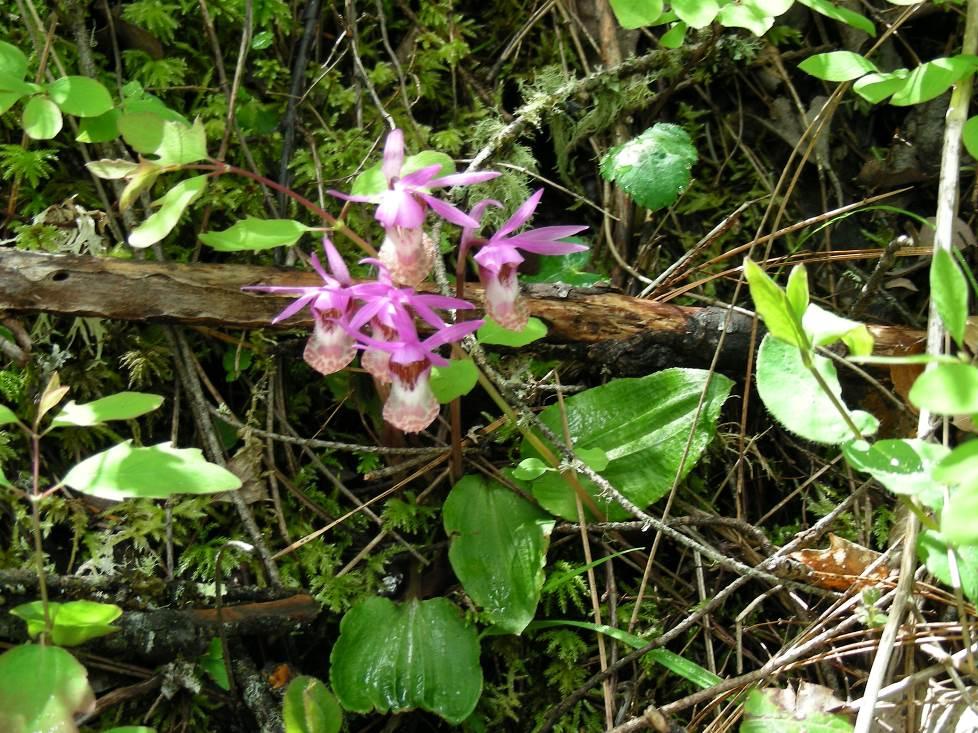
5 As the trail follows the contours of the land, it changes character many times, depending on the aspect of the slope. The terrain includes open oak, madrone, and manzanita woodlands, open meadows, and forested gulches. On the north-facing slopes there are stands of large Ponderosa Pine and Douglas Fir, and there are two seasonal waterfalls. The trail provides expansive views of the Siskiyou Crest, Little Applegate, and Applegate Valleys. The spring wildflowers are spectacular, including some rare and endemic species, and there is also a diverse population of birds and wildlife common to the region. There are some historic features along the trail, including a tunnel, rock walls, drilling scars where rock had to be dynamited to construct the ditch, and remnants of flumes that were constructed to cross gulches where it was not possible to continue the ditch. The Siskiyou Upland Trails Association (SUTA) is a non-profit organization that was formed in 2009 to maintain the SMDT and develop and maintain trails between the communities of Jacksonville and Ashland OR. SUTA partners with the Medford District BLM, the land manager for the SMDT and surrounding public lands. Until approximately 4 years ago, only a 5-mile loop of the SMDT was open and maintained. SUTA has led the effort to recruit volunteers and obtain grant funds to reopen much of the SMDT that had become overgrown and inaccessible. In addition to reopening more than 15 miles of the trail and constructing several new access trails, projects that have been completed include improving and expanding trailhead parking and access, installing signs and trailhead kiosks, preparing interpretive materials, and promoting the trail for non-motorized users. SUTA also sponsored two highly successful SMDT History Night events to highlight the rich history of the ditch and the gold mining legacy it represents.

6
7
8 Part 2 Public notification and stakeholder involvement A public meeting to notify stakeholders about the State Scenic Trails application and process was held on March 4, 2014 at the Jacksonville, OR library. The following stakeholders have been notified and requested to provide input about the Scenic Trails application process and what the Scenic Trail designation would mean for the SMDT and its users: The Medford District of the BLM, land manager for the SMDT and surrounding public lands. The Medford District s Recreation Planner is Jeanne Klein and the Ashland Resource Area Recreation Planner is Dennis Byrd. The BLM has reviewed and concurs with this Management Plan. Jackson County Parks and Recreation Department, Steve Lambert. Individual landowners who own property adjacent to the SMDT. Klamath-Siskiyou Wild and the Rogue Valley Chapter of the Sierra Club. Both organizations advocate for the public lands in the region and also sponsor hikes on the SMDT. User groups, including the Southern Oregon Runners and Rogue Valley Mountain Bike Association, Jackson County Horsemen, and Rogue Riders. The following methods have been used to notify potentially affected parties about the Scenic Trails application and process and how it would benefit users, businesses, landowners, and any other interested parties: Electronic SUTA has a comprehensive website ( that provides historical information, trail maps and descriptions, information about upcoming events, and links to the BLM and other pertinent websites. The Scenic Trails application and process are posted on the website. SUTA also has more than 250 people on its list and all participants have been notified about the Scenic Trials application and process via .
9 Print - SUTA frequently provides articles to the local community newspapers to provide information about trail activities, new trail segments, hike descriptions, and any other related news. The Medford Mail Tribune and Jacksonville Review have published several articles about the SMDT and trail activities in the past several years, and the Scenic Trails application and process has been published in as many print sources as possible. Social media SUTA has many Facebook friends and likes who receive trail activity updates and provide comments. The Scenic Trails application and process information have been shared via our Facebook page with a request for input. Outreach: SUTA works closely with other local trails groups such as the Applegate Trails Association, Ashland Woodland Trails Association, and Jacksonville Woodlands Trails Association as well as other user groups such as Southern Oregon Runners, Rogue Valley Mountain Bike Association, Rogue Riders Jackson County Horsemen Association, and Oregon Equestrian Trails (Rogue Valley Chapter). SUTA members also attend the Trail Coalition Meetings for the Rogue Valley. The Trails Coalition pulls together all trail user groups in the Rogue Valley, both motorized and non-motorized to build relationships and understanding with other trail user groups who do volunteer work and promote trails in the greater area. These groups have been notified and asked for input. Meeting documentation: All of the input received at the public meeting has been documented and reported to the Oregon Recreational Trails advisory council.
10 Part 3 Trail facility review Trail - The SMDT system has nearly 30 miles of single-track native surface trails open to the public for non-motorized use. The trail runs primarily along the top of the lower berm that was created when the ditch was constructed it is approximately 3 above the ditch, and approximately 5 wide. The tread width ranges from 12 to 18 inches. The trail sections along the ditch have a nearly level grade, while the access trails and sections constructed to bypass private property can range up to a 15% grade for short spans. The BLM breached the berm in places to prevent flooding, so occasionally short sections of the trail drop into the ditch to bypass these cuts. A few additional short trail sections follow the ditch because the berm has been overgrown by large trees or eroded by flooding. The SMDT system also connects to a number of unimproved or gravel BLM roads to form loops for longer distance recreational opportunities. Support facilities The trail has seven designated trail heads, four of which have horse trailer turnaround and parking areas. The trailheads and available amenities are shown in Table 1. In addition, wooden benches are placed at six locations along the trail to allow users to rest while enjoying the surroundings and often sweeping views, and short wooden puncheon bridges are located at Blacksmith and Muddy Gulch to provide safe and sustainable crossing at these small streams. Several of these are SUTA-sponsored Eagle Scout Projects. Table 1. SMDT Facilities Trailheads Car Parking Equestrian Parking Kiosk Trailhead signs and mileage signs Deming Gulch Yes Yes (Equestrian parking above trailhead) Yes Yes Armstrong Gulch Yes Yes Yes Yes Wolf Gap Yes Yes Yes Yes Grub Gulch Yes No Yes Yes (by 6/2014) Bear Gulch Yes No Yes Yes Tunnel Ridge Yes Yes Yes Yes Little Applegate Yes Yes Yes Yes
11 Signage SUTA has obtained funding over the past several years for information kiosks, new trail signs, and way-finding signs at key points along the trail. By mid-2014 the information kiosks will be installed at all trailheads, and all relevant signage will be placed on the trail and at key road junctions. Seasonally relevant interpretive information will be posted on the kiosks (e.g. guides to spring wildflowers, migrating birds, tree leaves, animal tracks, etc.), and SUTA will also install several interpretive signs at unique points, such as the tunnel at the top of Tunnel Ridge, and signs identifying the surrounding mountains. Future trail facility needs assessment - SUTA has identified several future trail facility needs, which will be reviewed and approved by BLM. All of the installation and construction field activities are also coordinated with BLM. The ability and timing to complete several of these projects will depend upon the availability of future funding, but they all are part of our long-term vision for the trail. Our list includes: 1. Reopen a short ditch section and construct a bridge over Deming Creek north of the Deming Equestrian Landing. A bridge will permit easier access and more sustainable conditions for lands on either side of this seasonal creek. 2. Create a new access trail and trail head between Yale Creek and Buncom along Little Applegate Road to provide access to a relatively remote trail section and introduce a mid-distance loop. 3. Create a by-pass around a large Madrone between the Bear Gulch and Tunnel Ridge trailheads to provide a long-term solution to a steep section of the trail that is susceptible to damage. 4. Install several equestrian water troughs along the trail. 5. Install additional rest benches (possible Eagle Scout projects) at selected locations along the trail where there are expansive views. 6. Gain National Historic Registry status for the trail due to its history and role in gold mining in Southern Oregon. 7. Purchase private inholding associated with key segment of the ditch between Armstrong and Deming Gulch: a 640 acre parcel is currently owned by a timber company. SUTA would like to obtain a permanent easement protecting the ditch on this land, purchase a portion of the land where the ditch travels or work with BLM to complete a land swap. Gaining control of this
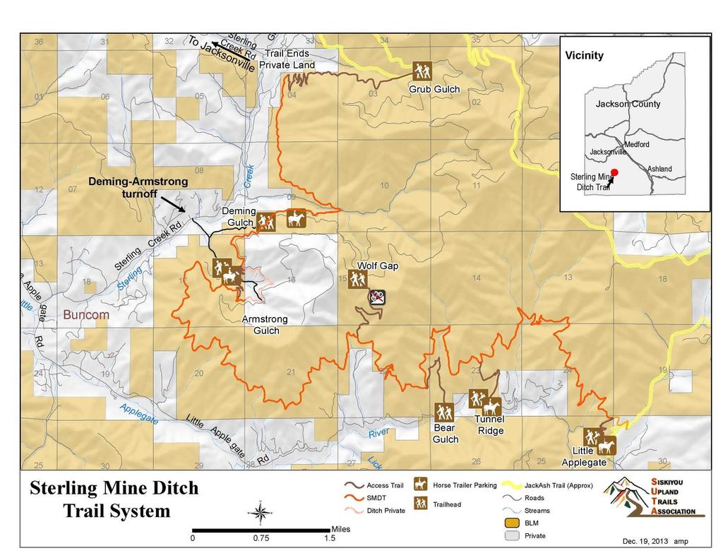
12 property would protect a heavily used portion of the trail and an extremely scenic section. The following map shows the locations of these proposed facilities.


13 36 01 Sterling Creek Rd To Jacksonville Trail Ends Private Land Vicinity Gri n Grub Gulch Jackson County 06 Medford Jacksonville le Apple Little Rd gate Buncom Deming-Armstrong turnoff Sterling Sterling Creek Rd Deming Gulch n!è Creek n Armstrong Gulch 09!È 16 po à 15 n ÆI 10 Wolf Gap!H po Sterling Mine 12 Ditch Trail 13 Ashland Applegate 20 New Access Trail Little Sterling Mine Ditch Trail System Yale Apple Creek Rd gate 28 Rd à ÆI Miles po Bridge Picnic Table Water Trough 27 River Lick Gulch Access Trail SMDT Ditch Private 34!È n Bear Gulch n!è Tunnel Ridge 26 Horse Trailer Parking n Trailhead n!è Little Applegate JackAsh Trail (Approx) Roads Streams BLM Private Feb. 10, 2014 amp
14 Part 4 Management, maintenance and monitoring The following describes the management, maintenance, and monitoring procedures in place for the SMDT trail system. Management Medford District BLM: With the exception of a few of short segments, the SMDT is located on public lands. The Medford District BLM has management responsibility for the trail system, and has been extremely supportive of SUTA s efforts to re-open the entire SMDT. The BLM continues its support by providing BLM and otherprofessional trail crews to perform large-scale chainsaw and trail work, as well as supporting our proposed projects to enhance the SMDT. The BLM provides tools and radios for use on volunteer trail work parties, and helps with production of required Environmental Impact Statements, trail brochures and more. MOU s: BLM and SUTA executed a MOU in early 2011 covering the SMDT as well as the future Jack-Ash trail. A copy of the BLM/SUTA MOU is provided in the Appendix. The MOU allows SUTA to serve as the community coordinator for the SMDT volunteer work crews, trail improvement projects, and events. SUTA: SUTA initiated re-opening the entire Sterling Mine Ditch Trail and has developed a strong working relationship with the Medford District BLM. We have taken the lead in continually monitoring conditions along the entire trail; we assess the conditions, develop an annual maintenance plan, implement improvements, and respond to un-anticipated conditions such as downed trees. SUTA organizes and leads volunteer trail maintenance work crews in the winter and spring months, and SUTA volunteers have participated in BLM s chainsaw certification courses, the Pacific Crest Trail/BLM-sponsored trails college to learn trail building and leadership skills, as well as BLM-sponsored first aid classes to gain skills for trail work crews. We report problems to BLM that are beyond our ability to address, such as felling or removing large hazard trees. SUTA has successfully applied for three years of funding through Title II projects as well as outside grants to fund specific trail improvements, ranging from parking lot enhancements or construction, to trail signs, kiosks and hiring trail construction crews. We coordinate all such projects with the Medford District BLM.
15 Ongoing stakeholder involvement: SUTA has been growing as a community trail association since its formation in The significant increase we ve observed in trail use is very encouraging and we anticipate ongoing community support. Attracting new volunteers to help with trail maintenance remains a constant challenge, but to date we have successfully recruited enough volunteers to lightly maintain the trail each year. With continued and expanded volunteer work party promotion through the local media and trail head kiosk displays, we expect increased participation. SUTA has organized and publicly presented two Sterling Mine Ditch History Night events. The first was held in 2011 at the Jacksonville Library, and was standing room only. The second was held in 2013 in a church in Jacksonville, and about 150 people attended. Both events were reported very positively in The Medford Mail Tribune. SUTA also actively promotes the SMDT by staffing a booth at local community events like Buncom Days, Applegate Days, and the Jacksonville and Medford Farmers Markets. The SMDT has been used for 5- and 10-mile races for the past two years by the Southern Oregon Runners Association, and the races are also planned for We anticipate other events will be sponsored on the SMDT, especially now that it is connected to a large network of BLM roads that allows long-distance recreational activities beyond the 30 miles of the SMCT and its access trails. Maintenance Coordination of Trail Maintenance: SUTA organizes volunteer work crews once a month from January through May. Our first trail work party was in the fall of 2009 and has continued with 4-5 work parties annually. The volunteer work crews have collectively logged more than 5,000 hours. A small group of board members and other volunteers determine which sections of the trail will need attention during the year s work parties. In the initial years of SUTA s involvement, our focus was on reopening the trail (in conjunction with BLM staff and professional crews) and repairing major tread problems. Now that the trail is fully opened, we can largely rely on fairly light brushing along much of the trail. For the past two years, our volunteer crews have brushed the majority of the ditch and access trails annually. In addition, when special projects arise, such as installing trail signs or kiosks, we enlist volunteers through our mailing list and Facebook Friends. Special projects such as bridge building, downed tree removal, or tread repair are usually handled outside of planned work parties, particularly if they require specific skills. We review our schedule and plans with the Medford District BLM. BLM has also provided professional trail crews such as the Job Council and Jackson County Community Justice trail crews on numerous occasions to focus on projects such as removing brush or stumps, and significant tread repair or refinement that require a greater degree of expertise and manpower.
16 Trail Standards: The Medford District BLM is responsible for coordinating the management of the SMDT and sets the trail standards that SUTA volunteers must comply with. The standards include everything from how the trail is to be maintained to the types of signage or kiosks allowed on the trail. Because this is an historic trail, all volunteers also must comply with strict archeological and cultural resource preservation requirements such as not disturbing the berm or any remaining artifacts along the ditch. Monitoring trail and support facility conditions, adjacent land use, level of use Existing plans review: There is no current maintenance plan in place specifically for the SMDT. The requirements of this application represent the first effort to provide for long-term trail maintenance planning. The only plan covering the SMDT and other recreational resources within the Medford District BLM is the Medford District BLM Resource Management Plan (RMP): The current RMP for the Medford District BLM encourages the development of recreational facilities such as the SMDT. Oregon Trails : A Statewide Action Plan that lays out a series of goals and objectives such as connectivity, trails close to population centers, and the need for additional non-motorized trails. This plan provided the inspiration for developing SUTA s community trail system. The SMDT meets many of these goals on its own but also as part of the larger Jack-Ash and SMDT system that will ultimately link several existing trail systems in the Rogue Valley. Planned improvements: Our planned improvements are divided into two categories: 1) the vision for how the trail maintenance will be conducted well into the future by instituting some ongoing improvements in annual trail clearing and 2) specific projects. Several of the planned projects are being funded by existing Title II grants. Others are coordinated efforts between BLM staff and SUTA volunteers. Our Future Vision of Trail Maintenance: 1. Trail Condition Surveys: Each fall SUTA has conducted a survey of trail conditions for the entire length of the trail. This is accomplished by board members and volunteers hiking or riding all of the sections of the trail. Based on this survey we plan the needed work parties for the winter. We anticipate continuing this practice as it allows us to monitor trail conditions. We have also posted a notice on all kiosks asking users to report downed trees or other trail hazards. 2. Vegetation management: Nature abhors a vacuum; annual growth of trees, shrubs and other plants requires ongoing maintenance to keep the trail open. While our volunteer work crews provide light brushing on most
17 of the ditch every year, by summer s end rapidly growing plants like poison oak encroach into the trail in some places. SUTA s original volunteer maintenance agreement restricted work to within a few feet of the trail (hands outstretched from the center of the trail). The Medford District BLM has now granted permission to more aggressively clear buck brush and other rapidly growing vegetation further out (approximately 6-8 feet) from the trail as needed and under their guidance. This will allow us to begin a more flexible trail maintenance rotation schedule, perhaps routinely maintaining some trail sections every-other year. This will improve sightlines for trail users. The goal is to keep the trail corridor clear year-round, even toward the end of the growing season. 3. Tread Management: As part of the long-term vision for the SMDT, SUTA would like to see the tread of the entire ditch provide a safe, stable surface for users. While the SMDT will always be a natural surface trail requiring users to pay attention, our long-term goal is to minimize hazards to the extent feasible on a trail through wild public lands. The trail travels through rocky areas and heavily forested sections, which requires users to be attentive to trail conditions. However, within reason, we want to ensure the tread is sloped correctly, is sufficiently wide, and to the extent possible, has minimal hazards such as stobs or hazardous branches close to the trail. SUTA anticipates the need to repair sections of the trail if large trees fall and damage the tread, and to maintain the outslope of the tread as it wears with use. 4. Professional versus Volunteer Maintenance Crews: SUTA will coordinate with BLM to arrange for professional trail crews to periodically aggressively clear encroaching vegetation and perform treadwork if large repairs are necessary. A different trail section will receive this treatment each year after four or five years the rotation will begin again. Although the precise number of miles and the frequency of this work will need to be determined with experience and trail conditions, we estimate that roughly six miles could be completed each year. Our volunteer trail crews can focus their efforts on trailhead infrastructure improvement and maintenance, light tread work, and light vegetation brushing on those portions of the trail in greatest need. 5. The Medford BLM staff has been and will continue to take responsibility for felling large hazard trees or downed trees that are not lying on the ground, or are larger diameter (greater than 14 inches) than the chainsaw-certified volunteers are authorized to cut.
18 Planned Maintenance Activities: 1. Although the majority of significant tread problems have been corrected over the past several years, we will focus further tread work to widen and outslope the tread to improve trail safety in some sections, especially in the central area of the trail between Armstrong and Wolf Gulch, the Little Applegate and Wolf Gulch By-passes, and the trail section north of the Deming Gulch Trailhead. 2. Removal of remaining stobs in the central section of the trail between Armstrong Gulch and Wolf Gulch (planned for 2014, supported by BLMprovided crews and/or committed Title II grant funds). 3. Complete installation of new signage and kiosks by late Spring 2014 (committed Title II and REI grant funds). 4. Complete the new Armstrong Gulch access trails and the Grub Gulch Access Trail by the end of spring 2014 (BLM staff and professional crews using Title II funds, and volunteers). 5. Install motorcycle barriers at key trail entrances to prevent unauthorized motorized use (committed Title II grant funds). 6. Develop additional interpretive material for wildflowers, birds, historical information that will be posted online and on the trailhead kiosks. Preparation of these materials is being coordinated with BLM naturalists and cultural resources specialists, and funded in part by committed Title II grant funds.
19 APPENDIX 1. Copy of BLM/SUTA MOU 2. Letters from BLM acknowledging continuing support of the SMDT State Scenic Trail application and this Management Plan
Rogue River Access and Management Plan Draft Alternatives
 Rogue River Access and Management Plan Draft Alternatives The Rogue River Access and Management Plan was initiated in December, 2011 and is being led by Jackson County Parks (JCP) and Oregon Department
Mt. Hood National Forest
 United States Department of Agriculture Forest Service Mt. Hood National Forest Zigzag Ranger District 70220 E. Highway 26 Zigzag, OR 97049 503-622-3191 Fax: 503-622-5622 File Code: 1950-1 Date: June 29,
EXECUTIVE SUMMARY PROGRAM DEVELOPMENT REPORT PURPOSE EXISTING SETTING EXPANDING PARKLAND
 EXECUTIVE SUMMARY PROGRAM DEVELOPMENT REPORT PURPOSE As the culmination of the first phase of the master planning process, this Program Development Report creates the framework to develop the Calero County
Recreation News. Welcome. Chris Jackson. In this Issue: O S U C o l l e ge F o r e s t s
 Recreation News O S U C o l l e ge F o r e s t s In this Issue: Welcome New tree identification posts... New Arboretum Trails New Interpretive Signs Ridge Trail Seasonal Closures Leave No Trace reminder
Non-motorized Trail Plan & Proposal. August 8, 2014
 Town of Star Valley Ranch, Wyoming and the Star Valley Ranch Association in partnership with the USDA Forest Service, Bridger-Teton National Forest, Greys River Ranger District Non-motorized Trail Plan
Rule Governing the Designation and Establishment of All-Terrain Vehicle Use Trails on State Land
 Rule Governing the Designation and Establishment of All-Terrain Vehicle Use Trails on State Land 1.0 Authority 1.1 This rule is promulgated pursuant to 23 V.S.A. 3506. Section 3506 (b)(4) states that an
Logo Department Name Agency Organization Organization Address Information 5700 North Sabino Canyon Road
 Logo Department Name Agency Organization Organization Address Information United States Forest Coronado National Forest 5700 North Sabino Canyon Road Department of Service Santa Catalina Ranger District
EAST DON TRAIL ENVIRONMENTAL ASSESSMENT. Community Liaison Committee Meeting #3 July 15, :30 to 8:30 pm Flemingdon Park Library
 EAST DON TRAIL ENVIRONMENTAL ASSESSMENT Community Liaison Committee Meeting #3 July 15, 2013 6:30 to 8:30 pm Flemingdon Park Library Agenda 1. Welcome 2. Housekeeping and Updates a) Housekeeping b) CLC
Salmo Ski Hill 2015 Operating Season SVTS Annual Work Plan
 Salmo Ski Hill 2015 Operating Season SVTS Annual Work Plan 2014 Review Our goal for 2014 had been to complete construction of a 2.5km loop trail (Figure 1) with scouting and possibly layout for the remainder
The Chu property is a 6.57 acre parcel located in the Town of Superior on the west side of McCaslin Boulevard. In 2014, the Town of Superior acquired
 1 The Chu property is a 6.57 acre parcel located in the Town of Superior on the west side of McCaslin Boulevard. In 2014, the Town of Superior acquired the Chu property for open space with a contribution
National Recreation Trail Application for Designation
 National Recreation Trail Application for Designation Introduction Thank you for your interest in the National Recreation Trail (NRT) program. Completed NRT application packages must be submitted by December
Chapter 6: POLICY AND PROCEDURE RECOMMENDATIONS
 Chapter 6 POLICY AND PROCEDURE RECOMMENDATIONS FOR SRRA Below are seven policy elements that should be considered for adoption by the Southwest Regional Recreation Authority of Virginia: 1. Develop strategies
Preferred Recreation Recommendations Stemilt-Squilchuck Recreation Plan March 2018
 Preferred Recreation Recommendations Stemilt-Squilchuck Recreation Plan March 2018 Below are the recommended recreation ideas and strategies that package together the various recreation concepts compiled
Trail Phasing Plan. Note: Trails in the Clear Creek Canyon area (Segments will be finalized in the future to minimize wildlife impacts
 Note: Trails in the Clear Creek Canyon area (Segments 2 5 and a future JCOS connection) will be finalized in the future to minimize wildlife impacts Trail Phasing Plan P Parking 3 Easy Trail Intermediate
Kelly Motorized Trails Project Proposed Action
 Kelly Motorized Trails Project Proposed Action November 28, 2011 The Flagstaff Ranger District of the Coconino National Forest is seeking public input on the proposed Kelly Motorized Trails Project (formerly
Nov. 19 th Public Workshop Summary
 On November 19 th, more than 60 community members attended an Open Space Matters workshop at the Linen Building in downtown Boise for over two hours. Participants learned about reserves, discussed the
S Central Coast Heritage Protection Act APRIL 21, 2016
 STATEMENT OF GLENN CASAMASSA ASSOCIATE DEPUTY CHIEF, NATIONAL FOREST SYSTEM U.S. FOREST SERVICE U.S. DEPARTMENT OF AGRICULTURE BEFORE THE UNITED STATES SENATE COMMITTEE ON ENERGY AND NATURAL RESOURCES
Mission. Purpose. Idaho Trails Association promotes the continued enjoyment of Idaho s hiking trails.
 The Idaho Trails Association (ITA) is a non-profit 501(c)3. Mission Idaho Trails Association promotes the continued enjoyment of Idaho s hiking trails. Purpose To facilitate the active enjoyment of Idaho
Understanding user expectations And planning for long term sustainability 1
 Understanding user expectations And planning for long term sustainability 1 What is a natural surface trail? It can be as simple has a mineral soil, mulched or graveled pathway, or as developed as elevated
Hermosa Area Preservation The Colorado Trail Foundation 4/11/2008
 Hermosa Area Preservation The Colorado Trail Foundation 4/11/2008 Legend d o Tr ail NPA - National Protection Area ra NCA - National Conservation Area o e C Th The Colorado Trail lo FS inventoried Roadless
MORGAN CREEK GREENWAY Final Report APPENDICES
 APPENDICES MORGAN CREEK GREENWAY Appendix A Photos of Existing Conditions in Trail Corridor Photos of existing conditions Main trail corridor - February 2009 Photos of existing conditions south bank Morgan
INTRODUCTION. Mailing address: Burke County Community Development Attn: Tim Johnson P. O. Box 219 Morganton, NC
 REQUEST FOR QUALIFICATIONS: PROFESSIONAL, EXPERIENCED TRAIL BUILDERS FOR THE CONSTRUCTION OF THE FONTA FLORA STATE TRAIL LAKE JAMES SECTION BURKE COUNTY COMMUNITY DEVELOPMENT INTRODUCTION Burke County
Request for Proposal National Tropical Botanical Garden Lower Limahuli Preserve Emergency Stream Debris Removal
 Request for Proposal National Tropical Botanical Garden Lower Limahuli Preserve Emergency Stream Debris Removal I. Summary of Work Bids are solicited for the emergency removal of debris deposited in the
MONTEREY REGIONAL AIRPORT MASTER PLAN TOPICAL QUESTIONS FROM THE PLANNING ADVISORY COMMITTEE AND TOPICAL RESPONSES
 MONTEREY REGIONAL AIRPORT MASTER PLAN TOPICAL QUESTIONS FROM THE PLANNING ADVISORY COMMITTEE AND TOPICAL RESPONSES Recurring topics emerged in some of the comments and questions raised by members of the
Pillar Park. Management Plan
 Pillar Park Management Plan January 2014 Pillar Park Management Plan Approved by: Jeff Leahy Regional Director Thompson Cariboo Region BC Parks January 9, 2014 Date Brian Bawtinheimer Executive Director
ROAD AND TRAIL PROJECT APPROVAL
 ROAD AND TRAIL PROJECT APPROVAL www.marincountyparks.org Marin County Parks, 3501 Civic Center Dr, Suite 260, San Rafael, CA 94903 DATE: July 12, 2017 PRESERVE: Gary Giacomini Open Space Preserve PROJECT:
PROPOSED PARK ALTERNATIVES
 8 Chimne y Rock State Park M a ster Pl an 2011 PROPOSED PARK ALTERNATIVES Introduction Three different park development concepts were prepared and presented to the citizens of North Carolina through a
Outreach Notice. FREMONT-WINEMA NATIONAL FOREST Zone Planning Staff GS Winter Rim Zone Paisley and Silver Lake Ranger Districts
 Outreach Notice FREMONT-WINEMA NATIONAL FOREST Zone Planning Staff GS-0401-11 Winter Rim Zone Paisley and Silver Lake Ranger Districts The Position This position is located on the Winter Rim Zone, Fremont-Winema
April 10, Mark Stiles San Juan Public Lands Center Manager 15 Burnett Court Durango, CO Dear Mark,
 Mark Stiles San Juan Public Lands Center Manager 15 Burnett Court Durango, CO 81301 Dear Mark, We are pleased to offer the following comments on the draft San Juan Public Lands Center management plans
FINAL TESTIMONY 1 COMMITTEE ON RESOURCES UNITED STATES HOUSE OF REPRESENTATIVES. July 13, 2005 CONCERNING. Motorized Recreational Use of Federal Lands
 FINAL TESTIMONY 1 STATEMENT OF DALE BOSWORTH CHIEF Of the FOREST SERVICE UNITED STATES DEPARTMENT OF AGRICULTURE Before the SUBCOMMITTEE ON FORESTS AND FOREST HEALTH And the SUBCOMMITTEE ON NATIONAL PARKS,
Prescott Park Trail System Event Management Guide
 Prescott Park Trail System Event Management Guide Medford Parks, Recreation & Facilities Management 701 N. Columbus Ave., Medford OR 97501-541.774.2400 parks@cityofmedford.org playmedford.com About the
US Forest Service Bears Ears Trail - NFST 1144 California Park to Hole in Wall Creek. Good (1) 2 3
 2 3") Trail Maintenance Endowment Fund Trail Criteria Form The Trail Maintenance Endowment Fund (TMEF) grant criteria form is used in determining the use of funds available on an annual basis. Decisions on how
Trail Maintenance Endowment Fund Trail Criteria Form The Trail Maintenance Endowment Fund (TMEF) grant criteria form is used in determining the use of funds available on an annual basis. Decisions on how
Wallace Falls State Park Classification and Management Planning Stage 3 Preliminary Recommendations July 18, 2018 Sultan City Hall
 Wallace Falls State Park Classification and Management Planning Stage 3 Preliminary Recommendations July 18, 2018 Sultan City Hall Thanks for coming! This document contains State Parks preliminary recommendations
BACKGROUND DECISION. Decision Memo Page 1 of 6
 DECISION MEMO DEVIL S ELBOW BY-PASS, BOUNDARY TRAIL NO.1 U.S. FOREST SERVICE T9N, R7E, SECTION 9 RANGE 5E COWLITZ COUNTY WA MOUNT ST. HELENS NATIONAL VOLCANIC MONUMENT, GIFFORD PINCHOT NATIONAL FOREST
APPENDIX D: SUSTAINABLE TRAIL DESIGN. APPENDICES Town of Chili Parks and Recreation Master Plan Update
 APPENDIX D: SUSTAINABLE TRAIL DESIGN APPENDICES Town of Chili Parks and Recreation Master Plan Update Sustainable Trail Construction Sustainable trails are defined by the US Forest Service as trails having
September 14, Comments of the Colorado Trail Foundation On the USFS Scoping Notice of August 13, 2010 RE: the relocation of the CDNST/CT Page 1
 THE COLORADO TRAIL FOUNDATION Comments on the U.S. Forest Service Scoping Notice of August 13, 2010 Regarding the Relocation of THE COLORADO TRAIL AND CONTINENTAL DIVIDE NATIONAL SCENIC TRAIL From La Garita
DECISION MEMO North Zone (Legacy Trails) Trail Stabilization Project
 Trail Stabilization Project") DECISION MEMO North Zone (Legacy Trails) Trail Stabilization Project USDA FOREST SERVICE Rocky Mountain Region (R2) Shoshone National Forest Wapiti and Greybull Ranger District Park County, Wyoming Background
DECISION MEMO North Zone (Legacy Trails) Trail Stabilization Project USDA FOREST SERVICE Rocky Mountain Region (R2) Shoshone National Forest Wapiti and Greybull Ranger District Park County, Wyoming Background
CHAPTER III: TRAIL DESIGN STANDARDS, SPECIFICATIONS & PERMITS
 CHAPTER III Trail Design Standards, Specifications & Permits This chapter discusses trail standards, preferred surface types for different activities, permits, and other requirements one must consider
Stevenson Ranch Library The Old Road, Stevenson Ranch, CA Thursday, November 9, :00-8:00 pm
 Stevenson Ranch Library 25950 The Old Road, Stevenson Ranch, CA 91381 Thursday, November 9, 2017 6:00-8:00 pm Project Team County of Los Angeles Department of Parks and Recreation Kathline King Chief of
Subj: POLICY FOR MAINSIDE TRAIL USE AT MARINE CORPS BASE QUANTICO
 UNITED STATES MARINE CORPS MARINE CORPS BASE QUANTICO, VIRGINIA 22134-5001 MCBO 5090.4 B 04 MARINE CORPS BASE ORDER 5090.4 From: Commander To: Distribution List Subj: POLICY FOR MAINSIDE TRAIL USE AT MARINE
5.0 OUTDOOR RECREATION OPPORTUNITIES AND MANAGEMENT
 5.0 OUTDOOR RECREATION OPPORTUNITIES AND MANAGEMENT 5.1 Introduction This section describes the range of recreational activities that currently take place in Marble Range and Edge Hills Parks, as well
Kit Carson-Challenger Ridge Trail Project
 Kit Carson-Challenger Ridge Trail Project Project Accomplishments Report-USFS December 15, 2015 Photo courtesy of Justin Peterson 815 South 25 th Street, Suite 101 Colorado Springs, CO 80904 Dedicated
Partners: Michigan California Timber Company Shasta-Trinity National Forest Pacific Crest Trail Association The Trust for Public Land
 Partners: Michigan California Timber Company Shasta-Trinity National Forest Pacific Crest Trail Association The Trust for Public Land Describe the project location, size, opportunities, and timing. Provide
Tracy Ridge Shared Use Trails and Plan Amendment Project
 Tracy Ridge Shared Use Trails and Plan Amendment Project Scoping Document Forest Service Allegheny National Forest Bradford Ranger District McKean, County, Pennsylvania In accordance with Federal civil
Daisy Dean Trail 628/619 ATV Trail Construction
 Background and Purpose and Need The Daisy Dean ATV Trail Construction Project is located in the Little Belt Mountains, Musselshell Ranger District, Lewis and Clark National Forest approximately 32 miles
Form for Project Descriptions - December 2013 version! 1. Stone Valley Cooperative Recreation Area (SVCRA) Project Description
 Project Description") Form for Project Descriptions - December 2013 version 1 Stone Valley Cooperative Recreation Area (SVCRA) Project Description The Stone Valley partners request that proposed work on land within the SVCRA
Form for Project Descriptions - December 2013 version 1 Stone Valley Cooperative Recreation Area (SVCRA) Project Description The Stone Valley partners request that proposed work on land within the SVCRA
March 14, SUBJECT: Public input to the Bureau of Land Management, Gunnison Field Office, Travel Management Plan
 March 14, 2019 Delivered via email to ewaters@blm.gov Elijah Waters Field Manager BLM Gunnison Field Office Gunnison, CO 81230 SUBJECT: Public input to the Bureau of Land Management, Gunnison Field Office,
Chambers of Commerce and Lake Groups advertised this NCWRPC created online survey that was : Opened: August 22, 2012; and Closed: October 4, 2012.
 Vilas County Outdoor Recreation Survey Chambers of Commerce and Lake Groups advertised this NCWRPC created online survey that was : Opened: August 22, 202; and Closed: October 4, 202. Q What Vilas County
Bibbulmun Track. Cape to Cape Track. Two of the world s great long distance walking tracks. 973 km. 135 km km Off-road cycle touring
 Trail revitalising Western Australia Bibbulmun Track 973 km Cape to Cape Track 135 km Two of the world s great long distance walking tracks 1062 km Off-road cycle touring Trail revitalising 1. Framework
RUSHMORE CONNECTOR TRAIL PROPOSAL
 PURPOSE AND NEED Background The U.S. Forest Service, Black Hills National Forest (Forest Service) has received a special use permit application from the State of South Dakota Department of Game, Fish and
Chatsworth Branch Library Devonshire Street, Chatsworth, CA Thursday, November 16, :00-8:00 pm
 Chatsworth Branch Library 21052 Devonshire Street, Chatsworth, CA 91311 Thursday, November 16, 2017 6:00-8:00 pm Project Team County of Los Angeles Department of Parks and Recreation Kathline King Chief
NATIONAL PARK SERVICE CERTIFICATION OF COMPLETED SEGMENTS OF THE NORTH COUNTRY NATIONAL SCENIC TRAIL
 NATIONAL PARK SERVICE CERTIFICATION OF COMPLETED SEGMENTS OF THE NORTH COUNTRY NATIONAL SCENIC TRAIL Completed trail segments that (1) follow the route identified in the 1982 National Park Service (NPS)
Fossil Creek Wild & Scenic River Comprehensive River Management Plan Forest Service Proposed Action - details March 28, 2011
 Fossil Creek Wild & Scenic River Comprehensive River Management Plan Forest Service Proposed Action - details March 28, 2011 Primary Goals of the Proposed Action 1. Maintain or enhance ORVs primarily by
City of Durango 5.8 FUNDING TRAILS DEVELOPMENT
 5.8 FUNDING TRAILS DEVELOPMENT The City has been successful in establishing dedicated local funding sources as well as applying for grants to develop the City s trail system, having received nearly $2.4
FEASIBILITY CRITERIA
 This chapter describes the methodology and criteria used to evaluate the feasibility of developing trails throughout the study areas. Land availability, habitat sensitivity, roadway crossings and on-street
Welcome to the future of Terwillegar Park a Unique Natural Park
 Welcome to the future of Terwillegar Park a Unique Natural Park 1 Introduction The Terwillegar Park Concept Plan study will develop an overall concept plan, management objectives and development guidelines
DATE: 23 March, 2011 TO: Communities FROM: BlazeSports America. RE: Accessible Trails Checklist 1
 M E M O R A N D U M DATE: 23 March, 2011 TO: Communities FROM: BlazeSports America RE: Accessible Trails Checklist 1 The purpose of the Accessible Trails Checklist (below) is to help the community review
December 3, Joan Dupes Administrative Asst
 The Conservation and Natural Resources Advisory Council s Review and Recommendations Regarding DCNR s Role and Responsibilities with Trail Maintenance in Pennsylvania December 3, 2008 Clifford C. David,
Appendix A. Tenderfoot Mountain Motorcycle Trail System. Maintenance and Construction Plan (6/13/13)
") Appendix A Tenderfoot Mountain Motorcycle Trail System Maintenance and Construction Plan (6/13/13) If the decision to implement the project as approved, grant funding would be pursued to fund construction
Appendix A Tenderfoot Mountain Motorcycle Trail System Maintenance and Construction Plan (6/13/13) If the decision to implement the project as approved, grant funding would be pursued to fund construction
Rogue Gorge (Mt. Stella) Roadless Area-- T30S R3E (primarily in portions of Sections 23, 26, 33, 34 & 35)
 Roadless Area-- T30S R3E (primarily in portions of Sections 23, 26, 33, 34 & 35)") Rogue Gorge (Mt. Stella) Roadless Area-- T30S R3E (primarily in portions of Sections 23, 26, 33, 34 & 35) Rogue River-Siskiyou National Forest--High Cascades Ranger District Upper, higher elevation trail
Rogue Gorge (Mt. Stella) Roadless Area-- T30S R3E (primarily in portions of Sections 23, 26, 33, 34 & 35) Rogue River-Siskiyou National Forest--High Cascades Ranger District Upper, higher elevation trail
Project Planning, Compliance, and Funding
 Project Planning, Compliance, and Funding The plans above offer high level guidance to ensure that the A.T. is managed effectively as a whole unit in a decentralized management structure. Cooperative management
Stephens State Park Trails
 TRAILS OF ALLAMUCHY MOUNTAIN & STEPHENS STATE PARKS Allamuchy Mountain and Stephens State Parks contain 28 marked trails providing access to diverse landscapes for walking, hiking, biking, bird-watching,
Table of Contents. page 3 Long term Goals Project Scope Project History. 4 User Groups Defined Trail Representative Committee. 5 Trail Users Breakdown
 Launched April 27th, 2010 1 Table of Contents page 3 Long term Goals Project Scope Project History 4 User Groups Defined Trail Representative Committee 5 Trail Users Breakdown 13 Trail Users Desires 16
PLANNING COMMISSION AGENDA REPORT May 10, Members of the Planning Commission. Joyce Parker-Bozylinski, Contract Planner
 PLANNING COMMISSION AGENDA REPORT May 10, 2007 TO: FROM: PROPOSAL: APPLICANT: RECOMMENDATION: Members of the Planning Commission Joyce Parker-Bozylinski, Contract Planner Approval of the Calabasas Trails
MASTER PLAN EXECUTIVE SUMMARY
 Biscuit Run State Park Scottsville Road (State Route 20) Charlottesville, VA 22902 Biscuit Run State Park MASTER PLAN EXECUTIVE SUMMARY Department of Conservation and Recreation Division of Planning and
American Conservation Experience
 ACE Project Report For Tonto National Forest, Arizona Trail Association and Arizona State Parks Title of Project: 4 Peaks Trail Maintenance Award Contract Number: ASP NM11021 Project Partner: Paul Burghard
Continental Divide National Scenic Trail Legislative History and Planning Guidance
 Continental Divide National Scenic Trail Legislative History and Planning Guidance Legislation, Policy, and Direction Regarding National Scenic Trails The National Trails System Act, P.L. 90-543, was passed
DECISION MEMO. Rawhide Trail #7073 Maintenance and Reconstruction
 Page 1 of 6 Background DECISION MEMO USDA Forest Service Jefferson Ranger District Jefferson County, Montana Rawhide Trail #7073 is located in the Elkhorn Mountain Range approximately 10 miles east of
Port Gamble Shoreline Area Conceptual Trail Proposal
 The North Kitsap Trails Association is pleased to be a partner to the Kitsap Forest and Bay Project and assist Kitsap County, Forterra, Olympic Property Group, Great Peninsula Conservancy and the Port
2. Goals and Policies. The following are the adopted Parks and Trails Goals for Stillwater Township:
 D. PARKS AND TRAILS 1. Introduction Stillwater Township s population is relatively low, with most residents living on rural residences on large lots. The need for active park space has been minimal in
13.1 REGIONAL TOURISM ISSUES AND SUMMARY OF FINDINGS
 13 REGIONAL TOURISM T he County of Mariposa s recreation needs and facilities fall within two categories: regional tourism and local recreation. This Element focuses on regional tourism issues related
Dixon Trail Construction - From the Top of the Mountain 2016 Interim Report Friends of Cheyenne Mountain State Park September 2 nd, 2016
 - Dixon Trail Construction - From the Top of the Mountain 2016 Interim Report Friends of Cheyenne Mountain State Park September 2 nd, 2016 Prepared by: Andy Riter, Program Coordinator, and Joe Lavorini,
National Recreation Trail Update Form
 National Recreation Trail Update Form Introduction Thank you for taking the time to complete this form. Your assistance will help ensure that the National Recreation Trail (NRT) database is complete and
Trail # NW Tuesday, June DESIGN. Provide an Review the Provide an. Project Goals: System system. wayfinding
 I. Welcome / Introductions Bethany Creek Trail #2 Segment 3 Neighborhood Meeting #1 Bethany Presbyterian Church 15505 NW Springville Road, Portland, OR 97229 Tuesday, June 26, 2018 @ 6:00PM Meeting Minutes
Creating a User-Driven Long-Distance OHV Trail Through Partnering
 Joseph Raffaele Outdoor Recreation Planner U.S. Bureau of Land Management Yuma, Arizona Creating a User-Driven Long-Distance OHV Trail Through Partnering BLM is a multiple-use land management agency within
Appendix 3. Greenway Design Standards. The Whitemarsh Township Greenway Plan
 Appendix 3 Greenway Design Standards This chapter discusses two design standards for the greenway types discussed above. First, trail design standards are presented together with trailhead facilities and
At the time, the portion of the line through Eagle County remains wholly under the ownership of Union Pacific Railroad (UP).
.") Chapter 5 The Railroad Corridor as a Trail Corridor The intent of this chapter is to identify how the rail corridor, if available for lease or purchase in all or part, could be incorporated into the core
Chapter 5 The Railroad Corridor as a Trail Corridor The intent of this chapter is to identify how the rail corridor, if available for lease or purchase in all or part, could be incorporated into the core
ASRA 2018 Hike Schedule
 ASRA 2018 Hike Schedule Date/Day Destination Hike Info Meeting Info Leader Feb 10, Saturday Stagecoach and 9:00 at the Confluence kiosk. Manzanita trails Parking fee required. We ll hike along the trail
Bob Marshall Wilderness Foundation
 About the Bob Marshall Wilderness Complex Considered by many to be the crown jewel of the wilderness preservation system, the Bob Marshall Wilderness Complex located in Northwestern Montana, is the third
Mickelson Connector Feasibility Study
 Friends of the Norbeck PO Box 2003 Rapid City, SD 57709 www.friendsofthenorbeck.org Summary Comments on the Mickelson Connector Feasibility Study Prepared by Brian Brademeyer Submitted to Wyss Associates
THAT the Board approve the final proposed concept plan for the Jericho Marginal Wharf site as shown in Figure C-4 of Appendix C.
 Date: January 17, 2012 TO: Board Members Vancouver Park Board FROM: General Manager Parks and Recreation SUBJECT: Jericho Marginal Wharf Phase 2 Concept Plan RECOMMENDATION THAT the Board approve the final
National Forests and Grasslands in Texas
 United States Department of Agriculture Forest Service National Forests and Grasslands in Texas Sam Houston NF 394 FM 1375 West New Waverly, Texas 77358 Phone 936-344-6205 Dear Friends, File Code: 1950
HIGHWAY 17 WILDLIFE and REGIONAL TRAIL CROSSINGS
 HIGHWAY 17 WILDLIFE and REGIONAL TRAIL CROSSINGS Agenda and Meeting Format 7:00-7:15 Welcome 7:15-8:00 Presentation 8:00-8:30 Open House 8:30 Recap 9:00 Conclusion 2 Meeting Goals: Introduce the project
Anderson Mt. Proposed Wilderness Additions to the Rogue-Umpqua Divide Wilderness-- T30S R3E (mostly) Sections 4 & 9, and T29S R3E Section 33
 Sections 4 & 9, and T29S R3E Section 33") Anderson Mt. Proposed Wilderness Additions to the Rogue-Umpqua Divide Wilderness-- T30S R3E (mostly) Sections 4 & 9, and T29S R3E Section 33 When the 35,701 acre Rogue-Umpqua Divide Wilderness was designated
Anderson Mt. Proposed Wilderness Additions to the Rogue-Umpqua Divide Wilderness-- T30S R3E (mostly) Sections 4 & 9, and T29S R3E Section 33 When the 35,701 acre Rogue-Umpqua Divide Wilderness was designated
Tahoe National Forest Over-Snow Vehicle Use Designation
 Tahoe National Forest Over-Snow Vehicle Use Designation USDA Forest Service Tahoe National Forest February 20, 2015 Introduction The Forest Service, U.S. Department of Agriculture will prepare an Environmental
AGENDA ITEM 5 D WAKULLA ENVIRONMENTAL INSTITUTE (WEI) TRAIL FEASIBILITY STUDY
 TRAIL FEASIBILITY STUDY") March 19, 2018 AGENDA ITEM 5 D WAKULLA ENVIRONMENTAL INSTITUTE (WEI) TRAIL FEASIBILITY STUDY TYPE OF ITEM: Action STATEMENT OF ISSUE The Wakulla Environmental Institute (WEI) Trail is one of several trails
March 19, 2018 AGENDA ITEM 5 D WAKULLA ENVIRONMENTAL INSTITUTE (WEI) TRAIL FEASIBILITY STUDY TYPE OF ITEM: Action STATEMENT OF ISSUE The Wakulla Environmental Institute (WEI) Trail is one of several trails
Welcome and thank you for being here! Kick-Off Public Workshop November 19, 2014
 Welcome and thank you for being here! Kick-Off Public Workshop November 19, 2014 OPEN SPACE MATTERS: Boise s First Reserve Master Plan Julia Grant Foothills and Open Space Manager City of Boise Ellen Campfield
Hiawatha National Forest St. Ignace Ranger District. File Code: 1950 Date: August 5, 2011
 United States Department of Agriculture Forest Service Hiawatha National Forest St. Ignace Ranger District W1900 West US-2 St. Ignace, MI 49781 906-643-7900 File Code: 1950 Date: August 5, 2011 Dear National
Trail Beginning Elevation: 7553 ft The Poison Creek Trailhead is located at the end of National Forest Road 646E (NF-646E).
.") West Mountain Trails Poison Creek Trail #134 Length: 2.9 miles (4.7 km) Difficulty Horseback: A good trail for the first time west mountain rider, some steep sections Hiking: Most Difficult USGS Maps:
West Mountain Trails Poison Creek Trail #134 Length: 2.9 miles (4.7 km) Difficulty Horseback: A good trail for the first time west mountain rider, some steep sections Hiking: Most Difficult USGS Maps:
BACKCOUNTRY TRAIL FLOOD REHABILITATION PROGRAM
 BACKCOUNTRY TRAIL FLOOD REHABILITATION PROGRAM Backcountry Trail Flood Rehabilitation A June 2013 Flood Recovery Program Summary In June 2013, parts of Southern Alberta were devastated from significant
Thank you for the opportunity to comment on the proposed action to add trails and trailheads to the Red Rock District trail system.
 July 14, 2010 Jennifer Burns Red Rock Ranger District PO Box 20429 Sedona, AZ 86341 Flagstaff Biking Organization PO Box 23851 Flagstaff, AZ 86002 Dear Jennifer- Thank you for the opportunity to comment
Appendix C. Tenderfoot Mountain Trail System. Road and Trail Rehabilitation Plan
 Appendix C Tenderfoot Mountain Trail System Road and Trail Rehabilitation Plan All rehabilitation work would be under the direction of the District Fisheries Biologist, the Forest Hydrologist, and/or the
Trail Town Program Creating Opportunities along the Nation s Trails. David Kahley President & CEO The Progress Fund
 Trail Town Program Creating Opportunities along the Nation s Trails David Kahley President & CEO The Progress Fund The Progress Fund Non-Profit Established 1997 CDFI with Rural Focus Provides Capital &
Proposal to Redevelop Lower Kananaskis River-Barrier Lake. Bow Valley Provincial Park. Frequently Asked Questions
 Proposal to Redevelop Lower Kananaskis River-Barrier Lake Bow Valley Provincial Park Frequently Asked Questions What is being proposed? What are the details of the proposal? Where is the project area located?
Regional Wayfinding Sign Strategy Thurston County Trails 2017
 Regional Wayfinding Sign Strategy Thurston County Trails 2017 Partners: Members and partnering organizations of the Thurston Thrives Community Design Action Team City of Lacey, City of Olympia, City of
Segment 2: La Crescent to Miller s Corner
 goal of the USFWS refuges is to conserve, protect and enhance fish, wildlife and plants and their habitats for the continuing benefit of the American people. Refuge lands are used largely for fishing,
DRAFT - APRIL 13, 2007 ROUTING STUDY FOR TRAIL CONNECTIONS BETWEEN CALAIS AND AYERS JUNCTION
 DRAFT - APRIL 13, 2007 ROUTING STUDY FOR TRAIL CONNECTIONS BETWEEN CALAIS AND AYERS JUNCTION Abstract The vision for the East Coast Greenway is an off-road urban trail system running from Calais, Maine
Procedure for the Use of Power-Driven Mobility Devices on Mass Audubon Sanctuaries 1 September 17, 2012
 Procedure for the Use of Power-Driven Mobility Devices on Mass Audubon Sanctuaries 1 September 17, 2012 Background As part of Mass Audubon s mission to preserve the nature of Massachusetts for people and
Chorley Park Trail Connection New Design Options. Information Booklet Prepared for June 9, 2014 Public Meeting
 Chorley Park Trail Connection New Design Options Information Booklet Prepared for June 9, 2014 Public Meeting Chorley Park Trail Booklet June 9, 2014 Page 1 of 12 Our Goals for the Chorley Park Trail Connection
Proposed Project 1: Kimble Loop East Horse Trail Reroute (1). Horse Trail Reroute: March 14, 2012
. Horse Trail Reroute: March 14, 2012") Proposed Project 1: Kimble Loop East Horse Trail Reroute The Ironton District Ranger requests your comments on proposed trail project on National Forest System lands. (1). Horse Trail Reroute: The proposed
Proposed Project 1: Kimble Loop East Horse Trail Reroute The Ironton District Ranger requests your comments on proposed trail project on National Forest System lands. (1). Horse Trail Reroute: The proposed