Stevenson Ranch Library The Old Road, Stevenson Ranch, CA Thursday, November 9, :00-8:00 pm
|
|
|
- Rosalyn Porter
- 5 years ago
- Views:
Transcription

1 Stevenson Ranch Library The Old Road, Stevenson Ranch, CA Thursday, November 9, :00-8:00 pm

2 Project Team County of Los Angeles Department of Parks and Recreation Kathline King Chief of Planning Michelle O'Connor Trails Planning Section Head Zachary Likins Project Manager Julie Yom CEQA Lead Sapphos Environmental, Inc. Marie Campbell President Laura Male Project Manager Alta Planning+Design, Inc. James Powell Project Lead Matthew Wild Trail Designer With support from Fifth District Supervisor Kathryn Barger 3 Santa Susana Mountains Trails Master Plan Phase II
3 Purpose of the Meeting Describe the Proposed Project Provide an overview of the California Environmental Quality Act (CEQA) process Provide key dates and deadlines for engagement Present the Proposed Mitigated Negative Declaration (MND) Findings Solicit input from the community 4 Santa Susana Mountains Trails Master Plan Phase II


4 Project Background Rich history of trail use, acquisition, and planning with strong support from the Board of Supervisors and various agencies in the region 5 Santa Susana Mountains Trails Master Plan Phase II

5 Project Background Statistics LA County has over 210 miles of existing regional multi-use trails. In recent years, the County has made significant investments in comprehensive planning for trails, trail maintenance, and trail development in response to the increased demand for trails. Running / jogging / trail running, bicycling, and hiking are among the top 5 most popular outdoor activities. There are an estimated 10.2 million people in Los Angeles County in 2016, and the population is expected to grow by almost 1 million by Santa Susana Mountains Trails Master Plan Phase II
 Los Angeles County Signage Program (2016) Los Angeles Countywide Comprehensive Parks & Recreation Needs Assessment (2016) 7 Santa Susana Mountains Trails Master Plan Phase II")
6 Project Background Los Angeles County Trails Manual (2013) Los Angeles County Trails Website (2015) Santa Susana Mountains Trails Master Plan Phase I (adopted 2015) Castaic Area Multi-Use Trails Plan (adopted 2016) Los Angeles County Signage Program (2016) Los Angeles Countywide Comprehensive Parks & Recreation Needs Assessment (2016) 7 Santa Susana Mountains Trails Master Plan Phase II

7 LA County Trails Website: trails.lacounty.gov Provides detailed, regularly updated information on trails, and allows users to: Show or search for trails based on current location or city/zip View, sort, and filter trail results to be viewed in the list view or map view Provide trail information, directions to trailhead and access points, an interactive map, elevation profile, etc. 8 Santa Susana Mountains Trails Master Plan Phase II

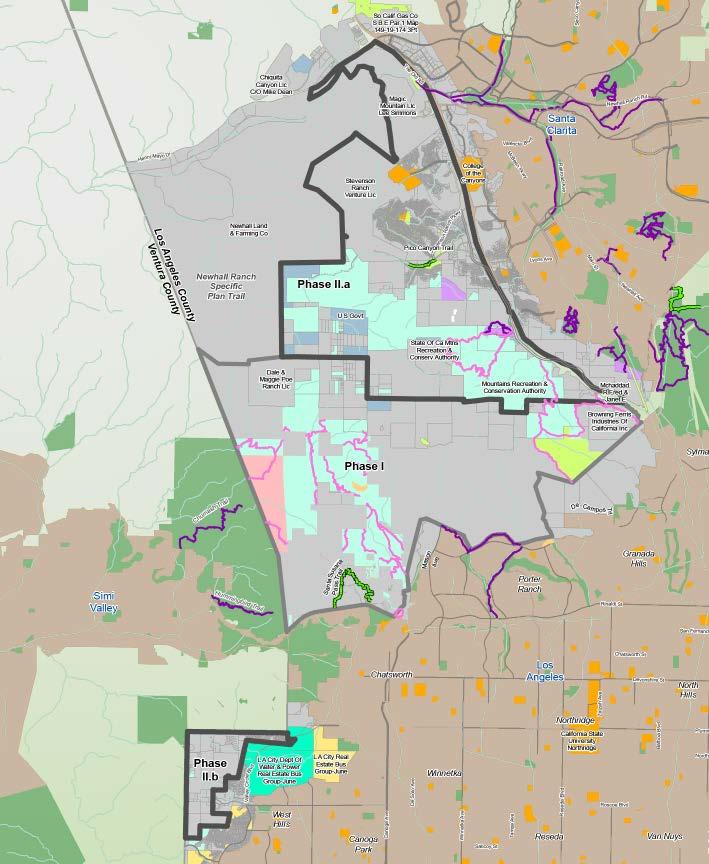
8 Project Overview: Study Area Study area encompasses approximately 24 square miles State Route-126 to the north Interstate-5 and the City of Los Angeles to the east City of Los Angeles and Phase I of the Santa Susana Mountains Final Trails Master Plan Area to the south Newhall Ranch Specific Plan Area and Ventura County to the west Adjacent to the communities of Val Verde, Chatsworth, and West Hills 9 Santa Susana Mountains Trails Master Plan Phase II


9 Project Process and Timeline 10 Santa Susana Mountains Trails Master Plan Phase II

10 Project Goals #1: Develop a complete multi-use trail system connecting user groups and local populations to desired recreation destinations and experiences, with seamless transitions to the trails of adjacent jurisdictions, compatibility with adjacent land uses and environmental resources, and a safe and sustainable design. 11 Santa Susana Mountains Trails Master Plan Phase II

11 Project Goals #2: Develop a recreational trail system that supports lowintensity use, including mountain biking, equestrian use, and hiking, to accommodate the population increase anticipated in the Santa Clarita Valley and San Fernando Valley planning areas. 12 Santa Susana Mountains Trails Master Plan Phase II


12 Project Objectives 1. Accommodate a wide range of trail user types and abilities, consistent with the County s multi-use trail policy. 2. Connect to desirable destinations, features, and settings. 3. Provide safe and sustainable trails. 4. Avoid or minimize environmental impacts. 5. Develop a strategy to implement and maintain trails identified within the Trails Master Plan. 6. Emphasize trails that close gaps in existing trail networks and provide regional connectivity. 7. Develop a plan consistent with relevant County plans and policies. 13 Santa Susana Mountains Trails Master Plan Phase II

13 Benefits of Trails Master Planning Support the expansion and overall connectivity of the County s regional multi-use trail network in a manner compatible with adjacent land uses and environmental resources Encourage and promote informed use of authorized County trails by the public Recommend and prioritize improvements to existing trails 14 Santa Susana Mountains Trails Master Plan Phase II

14 Benefits of Trails Master Planning Provide seamless transitions between trails of adjacent jurisdictions and prime destinations within and adjacent to the study area Provide increased recreational opportunities to meet increased need for access to parks and open space Attract or obtain funding for trail development and/or maintenance 15 Santa Susana Mountains Trails Master Plan Phase II

15 Potential Benefits to Property Owners 1. Planned and managed trail development can help prevent trespassing and discourage unauthorized use by focusing users to authorized areas. 2. Authorized trails help pass the liability risks and hazards of trail use from the property owner to the trail user. 3. Any trails proposed as part of this master plan will be conceptual in nature, and no development will take place without the consent of property owners. 16 Santa Susana Mountains Trails Master Plan Phase II
16 Process: Acknowledge Land Ownership 17 Santa Susana Mountains Trails Master Plan Phase II


17 Process: Topography 18 Santa Susana Mountains Trails Master Plan Phase II


18 Environmental Opportunities and Constraints 19 Santa Susana Mountains Trails Master Plan Phase II


19 Process: Network Gaps and Barriers DISCLAIMER: Some trails shown do not exist currently and are planned for the future, or they exist but are not officially designated. Permission to use trails shown on this map should not be assumed. Some trails may traverse private property and suggested alignments do not imply rights of public use. 20 Santa Susana Mountains Trails Master Plan Phase II

20 Process: Network Gaps and Barriers DISCLAIMER: Some trails shown do not exist currently and are planned for the future, or they exist but are not officially designated. Permission to use trails shown on this map should not be assumed. Some trails may traverse private property and suggested alignments do not imply rights of public use. 21 Santa Susana Mountains Trails Master Plan Phase II


21 Process: Public User Input DISCLAIMER: Some trails shown do not exist currently and are planned for the future, or they exist but are not officially designated. Permission to use trails shown on this map should not be assumed. Some trails may traverse private property and suggested alignments do not imply rights of public use. 22 Santa Susana Mountains Trails Master Plan Phase II

22 Project At-a-Glance Approximately 87 Miles of Trails 17 miles of existing trails 70 miles of planned trails Proposes 20 Trail Facilities 4 Trailheads 2 Equestrian Parks 2 Bike Skills Areas 8 Trailhead and Staging Areas 4 Trailheads Outside Study Area Up to 12 Restrooms Up to 12 Parking Areas 23 Santa Susana Mountains Trails Master Plan Phase II


23 Proposed Trails Master Plan: Phase II.a EUGENE TO ADD FIGURE DISCLAIMER: Some trails shown do not exist currently and are planned for the future, or they exist but are not officially designated. Permission to use trails shown on this map should not be assumed. Some trails may traverse private property and suggested alignments do not imply rights of public use. 24 Santa Susana Mountains Trails Master Plan Phase II


24 Proposed Trails Master Plan: Phase II.a Many existing bridges connect trails in Pico Canyon in the Phase II.a area. The Towsley Canyon Loop Trail follows a creek to meander through two ridges towards a slim gap called the Narrows. Existing trails around Pico Canyon are lined with Coast Live Oak trees. 25 Santa Susana Mountains Trails Master Plan Phase II

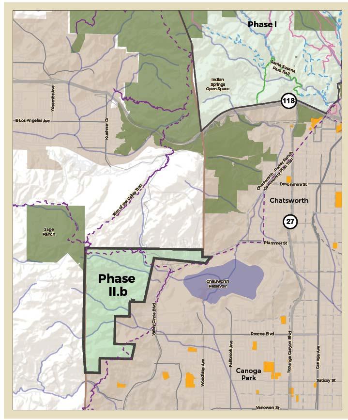
25 Proposed Trails Master Plan: Phase II.b DISCLAIMER: Some trails shown do not exist currently and are planned for the future, or they exist but are not officially designated. Permission to use trails shown on this map should not be assumed. Some trails may traverse private property and suggested alignments do not imply rights of public use. 26 Santa Susana Mountains Trails Master Plan Phase II


.")
26 Proposed Trails Master Plan: Phase II.b The Chatsworth Reservoir, now a nature preserve, sits beneath the boulder topped ridges of the Phase II.b area. The Santa Monica Mountains are seen to the west. Long views are offered from many peaks in the Phase II.b area (such as view of Twelve Apostles in Ventura County). 27 Santa Susana Mountains Trails Master Plan Phase II

27 Overview of the CEQA Process 45-day Public Review Period (Nov. 2-Dec. 16, 2017) Nov. 9, 2017 Public Meeting Nov. 16, 2017 Public Meeting Prepare & Publish Response to Comments Present Proposed MND and Trails Master Plan to County Board of Supervisors for Consideration in Santa Susana Mountains Trails Master Plan Phase II
28 Mitigated Negative Declaration Findings 15 of 19 CEQA issues determined to have no impacts or less than significant impacts: Agriculture/Forestry Air Quality Energy Geology/Soils Greenhouse Gas Emissions Hazards/Hazardous Materials Hydrology/Water Quality Land Use/Planning Mineral Resources Noise Population/Housing Public Services Recreation Transportation/ Traffic Utilities/Service Systems 29 Santa Susana Mountains Trails Master Plan Phase II


 30 Santa Susana Mountains Trails Master")
29 Mitigated Negative Declaration Findings 4 of 19 CEQA issues determined to have potential for significant impacts that would be reduced to below the level of significance with the implementation of mitigation measures (MMs): Aesthetics (state scenic highways; 2 MMs) Biological Resources (habitat loss, nesting birds, use of native wildlife nursery sites, potential for removal of mature trees; 4 MMs) Cultural Resources (significance of prehistoric and historical resources; 4 MMs) Tribal Cultural Resources (significance of tribal cultural resources; 3 MMs) 30 Santa Susana Mountains Trails Master Plan Phase II

30 Opportunities to Provide Input At Today s Meeting: 1. General Questions 2. In-Person Comments 3. Comment Cards Outside of Today s Meeting: 1. SantaSusanaTrailsPlan.org 2. Upcoming Public Meeting November 16, 2017 from 6-8 pm at Chatsworth Branch Library Devonshire Street, Chatsworth, CA Letters of Comment via mail or All comments must be received by December 16, Santa Susana Mountains Trails Master Plan Phase II

31 Opportunities for Public Participation Comment period opens November 2, 2017 and closes December 16, 2017 Comments should be sent to: County of Los Angeles Department of Parks and Recreation Attn: Julie Yom, Park Planner 510 South Vermont Avenue, Los Angeles, California Comments can also be provided at Board of Supervisors Hearing Spring Santa Susana Mountains Trails Master Plan Phase II

32 Thank You! For more information, please contact: Zachary Likins Project Manager: Please visit the project website at: For more information on existing trails, visit:
Chatsworth Branch Library Devonshire Street, Chatsworth, CA Thursday, November 16, :00-8:00 pm
 Chatsworth Branch Library 21052 Devonshire Street, Chatsworth, CA 91311 Thursday, November 16, 2017 6:00-8:00 pm Project Team County of Los Angeles Department of Parks and Recreation Kathline King Chief
EXECUTIVE SUMMARY PROGRAM DEVELOPMENT REPORT PURPOSE EXISTING SETTING EXPANDING PARKLAND
 EXECUTIVE SUMMARY PROGRAM DEVELOPMENT REPORT PURPOSE As the culmination of the first phase of the master planning process, this Program Development Report creates the framework to develop the Calero County
ROAD AND TRAIL PROJECT APPROVAL
 ROAD AND TRAIL PROJECT APPROVAL www.marincountyparks.org Marin County Parks, 3501 Civic Center Dr, Suite 260, San Rafael, CA 94903 DATE: July 12, 2017 PRESERVE: Gary Giacomini Open Space Preserve PROJECT:
Section II. Planning & Public Process Planning for the Baker/Carver Regional Trail began in 2010 as a City of Minnetrista initiative.
 Section II Planning & Public Process Planning for the began in 2010 as a City of initiative. city staff began discussions with the Park District on the possibility of a north/south regional trail connection
Williamson Rock/Pacific Crest National Scenic Trail (PCT) Project EIS. Notice of intent to prepare an Environmental Impact Statement.
 Project EIS. Notice of intent to prepare an Environmental Impact Statement.") [3411-15-P] DEPARTMENT OF AGRICULTURE Forest Service Angeles National Forest; Los Angeles County, CA Williamson Rock/Pacific Crest National Scenic Trail (PCT) Project EIS AGENCY: ACTION: Forest Service,
[3411-15-P] DEPARTMENT OF AGRICULTURE Forest Service Angeles National Forest; Los Angeles County, CA Williamson Rock/Pacific Crest National Scenic Trail (PCT) Project EIS AGENCY: ACTION: Forest Service,
PLANNING COMMISSION AGENDA REPORT May 10, Members of the Planning Commission. Joyce Parker-Bozylinski, Contract Planner
 PLANNING COMMISSION AGENDA REPORT May 10, 2007 TO: FROM: PROPOSAL: APPLICANT: RECOMMENDATION: Members of the Planning Commission Joyce Parker-Bozylinski, Contract Planner Approval of the Calabasas Trails
Scoping Meeting LAX Landside Access Modernization Program
 Welcome Scoping Meeting LAX Landside Access Modernization Program Thursday, February 19, 2015 5:00 p.m. to 8:00 p.m. Proud Bird Restaurant 11022 Aviation Boulevard Los Angeles, CA 90045 Welcome Scoping
Citrus Heights Creek Corridor Trail Project Trail Advisory Group Field Trip #2 September 11, :00 11:00 am Trellis Hall, Citrus Heights
 September 11, 2013 9:00 11:00 am Trellis Hall, Citrus Heights Project Overview The City of Citrus Heights is studying the feasibility of establishing a multi use trail system within the City s 26 miles
David Magney Environmental Consulting
 David Magney Environmental Consulting DELINEATION OF JURISDICTIONAL WATERS AND RIPARIAN HABITATS FOR LYONS CANYON RANCH, NEWHALL, CALIFORNIA Prepared for: UNITED STATES ARMY CORPS OF ENGINEERS and CALIFORNIA
Blueways: Rivers, lakes, or streams with public access for recreation that includes fishing, nature observation, and opportunities for boating.
 Parks, Open Space and Trails PRINCE WILLIAM COUNTY 2008 COMPREHENSIVE PLAN TRAILS PLAN CONTENTS The components of the trails plan are: Intent Definitions Goals, Policies, and Action Strategies Trails Map
PROPOSED ACTION South 3000 East Salt Lake City, UT United States Department of Agriculture
 United States Department of Agriculture Forest Service Uinta-Wasatch-Cache National Forest Salt Lake Ranger District 6944 South 3000 East Salt Lake City, UT 84121 801-733-2660 File Code: 1950/2300 Date:
The Chu property is a 6.57 acre parcel located in the Town of Superior on the west side of McCaslin Boulevard. In 2014, the Town of Superior acquired
 1 The Chu property is a 6.57 acre parcel located in the Town of Superior on the west side of McCaslin Boulevard. In 2014, the Town of Superior acquired the Chu property for open space with a contribution
(213) phone (213) fax Wilshire Boulevard Suite 660 Los Angeles, CA
 phone (213) fax Wilshire Boulevard Suite 660 Los Angeles, CA") 3435 Wilshire Boulevard Suite 660 Los Angeles, CA 90010-1904 (213) 387-4287 phone (213) 387-5383 fax www.sierraclub.org Julia Yom, Park Planner County of Los Angeles Department of Parks and Recreation
3435 Wilshire Boulevard Suite 660 Los Angeles, CA 90010-1904 (213) 387-4287 phone (213) 387-5383 fax www.sierraclub.org Julia Yom, Park Planner County of Los Angeles Department of Parks and Recreation
NOTICE OF PREPARATION/NOTICE OF PUBLIC SCOPING MEETING
 Notice Of Preparation/Notice of Public Scoping Meeting for a Draft Environmental Impact Report for the Airport Park Expansion Project CITY OF SANTA MONICA CITY PLANNING DIVISION 685 MAIN STREET, ROOM 22
CHAPTER 5. Chapter 5 Recreation Element
 CHAPTER 5 Recreation Element Chapter 5 Recreation Element The Recreation Element of the Meyers Area Plan is a supplement to the Recreation Element of the TRPA Regional Plan and the El Dorado County General
COASTAL CONSERVANCY. Staff Recommendation September 22, 2011 BAY AREA RIDGE TRAIL: HOOD MOUNTAIN TO HIGHWAY 12
 COASTAL CONSERVANCY Staff Recommendation September 22, 2011 BAY AREA RIDGE TRAIL: HOOD MOUNTAIN TO HIGHWAY 12 File No. 11-039-001 Project Manager: Betsy Wilson RECOMMENDED ACTION: Authorization to disburse
Georgetown-Lewes Rail/Trail Study. Rail/Trail Study: Cool Spring to Cape Henlopen State Park New Road Extension (House Resolution No.
 Georgetown-Lewes Rail/Trail Study Rail/Trail Study: Cool Spring to Cape Henlopen State Park New Road Extension (House Resolution No. 47) August 22, 2011 Presentation Outline Background Benefits Statewide
Logo Department Name Agency Organization Organization Address Information 5700 North Sabino Canyon Road
 Logo Department Name Agency Organization Organization Address Information United States Forest Coronado National Forest 5700 North Sabino Canyon Road Department of Service Santa Catalina Ranger District
FEASIBILITY CRITERIA
 This chapter describes the methodology and criteria used to evaluate the feasibility of developing trails throughout the study areas. Land availability, habitat sensitivity, roadway crossings and on-street
13.1 REGIONAL TOURISM ISSUES AND SUMMARY OF FINDINGS
 13 REGIONAL TOURISM T he County of Mariposa s recreation needs and facilities fall within two categories: regional tourism and local recreation. This Element focuses on regional tourism issues related
EAST DON TRAIL ENVIRONMENTAL ASSESSMENT. Community Liaison Committee Meeting #3 July 15, :30 to 8:30 pm Flemingdon Park Library
 EAST DON TRAIL ENVIRONMENTAL ASSESSMENT Community Liaison Committee Meeting #3 July 15, 2013 6:30 to 8:30 pm Flemingdon Park Library Agenda 1. Welcome 2. Housekeeping and Updates a) Housekeeping b) CLC
Thank you for this second opportunity to comment on the proposed revisions to the Coconino National Forest Management plan.
 March 8, 2011 Flagstaff Biking Organization PO Box 23851 Flagstaff, AZ 86002 Yewah Lau Coconino National Forest Attn: Plan Revision 1824 South Thompson Street Flagstaff, Arizona 86001 Sent via electronic
Preferred Recreation Recommendations Stemilt-Squilchuck Recreation Plan March 2018
 Preferred Recreation Recommendations Stemilt-Squilchuck Recreation Plan March 2018 Below are the recommended recreation ideas and strategies that package together the various recreation concepts compiled
AGENDA ITEM 5 D WAKULLA ENVIRONMENTAL INSTITUTE (WEI) TRAIL FEASIBILITY STUDY
 TRAIL FEASIBILITY STUDY") March 19, 2018 AGENDA ITEM 5 D WAKULLA ENVIRONMENTAL INSTITUTE (WEI) TRAIL FEASIBILITY STUDY TYPE OF ITEM: Action STATEMENT OF ISSUE The Wakulla Environmental Institute (WEI) Trail is one of several trails
March 19, 2018 AGENDA ITEM 5 D WAKULLA ENVIRONMENTAL INSTITUTE (WEI) TRAIL FEASIBILITY STUDY TYPE OF ITEM: Action STATEMENT OF ISSUE The Wakulla Environmental Institute (WEI) Trail is one of several trails
COASTAL CONSERVANCY. Staff Recommendation December 2, 2004 COYOTE HELLYER COUNTY PARK BAY AREA RIDGE TRAIL
 COASTAL CONSERVANCY Staff Recommendation December 2, 2004 COYOTE HELLYER COUNTY PARK BAY AREA RIDGE TRAIL File No. 04-057 Project Manager: Amy Hutzel RECOMMENDED ACTION: Authorization to disburse up to
Thank you for the opportunity to comment on the proposed action to add trails and trailheads to the Red Rock District trail system.
 July 14, 2010 Jennifer Burns Red Rock Ranger District PO Box 20429 Sedona, AZ 86341 Flagstaff Biking Organization PO Box 23851 Flagstaff, AZ 86002 Dear Jennifer- Thank you for the opportunity to comment
COMMENT PERIOD INTRODUCTION
 To: Interested Persons From: Tom Buford File: Del Rio Trail Project Date: June 8, 2018 Community Development Department Reference: NOTICE OF PREPARATION OF AN ENVIRONMENTAL IMPACT REPORT FOR THE DEL RIO
Martinez General Plan 2035 White Paper TRAILS
 Martinez General Plan 2035 White Paper TRAILS November 2016 The Issue The draft Martinez General Plan 2035 and Draft Program Environmental Impact Report were released for public review on September 15,
Update on Trinity Trails. Presented by: Richard Zavala, Director Park and Recreation Department February 7, 2017
 Update on Trinity Trails Presented by: Richard Zavala, Director Park and Recreation Department February 7, 2017 Overview Provide review of trail planning and development along the main stem Trinity River
PROPOSED PARK ALTERNATIVES
 8 Chimne y Rock State Park M a ster Pl an 2011 PROPOSED PARK ALTERNATIVES Introduction Three different park development concepts were prepared and presented to the citizens of North Carolina through a
Kelly Motorized Trails Project Proposed Action
 Kelly Motorized Trails Project Proposed Action November 28, 2011 The Flagstaff Ranger District of the Coconino National Forest is seeking public input on the proposed Kelly Motorized Trails Project (formerly
SECTION 5.12 Parks and Recreation
 SECTION 5.12 Parks and Recreation 5.12 PARKS AND RECREATION This section summarizes current parks and recreational facilities in the City of Santa Clarita and surrounding area, evaluates the impacts of
PALO CORONA REGIONAL PARK MPRPD BOARD MEETING AUGUST 8, 2018
 PALO CORONA REGIONAL PARK MPRPD BOARD MEETING AUGUST 8, 2018 ACKNOWLEDGEMENTS AGENCIES AND ORGANIZATIONS The Trust for Public Land Big Sur Land Trust Santa Lucia Conservancy California State Parks Point
January 14, Orange County Transportation Authority Attn: M2 NCCP/HCP 550 South Main Street P.O. Box Orange, CA
 Equestrian Trails, Inc. Corral 357 P.O. Box 1026 Trabuco Canyon, CA 92678 http://saddlebackcanyonriders.com/ President: James Iacono... 714-612-1789 January 14, 2016 Orange County Transportation Authority
Shelf Road Recreation Area 2015 BLM Annual Report of Rocky Mountain Field Institute Stewardship Under BLM Agreement L12AC20483 November 19, 2015
 Summary Shelf Road Recreation Area 2015 BLM Annual Report of Rocky Mountain Field Institute Stewardship Under BLM Agreement L12AC20483 November 19, 2015 Managed by the BLM Royal Gorge Field Office, Shelf
TRAIL ANNUAL REPORT
 TRAIL ANNUAL REPORT 2016-17 Identify Undeveloped projects identified in the City s Greenprint or trail database 15.90 miles Study Projects that have been or are currently being studied to determine a feasible
Park to Playa Trail. June 17, 2014
 Park to Playa Trail June 17, 2014 Representatives: Park to Playa Trail Karly Katona, Deputy for Sustainability & Economic Development, Office of Supervisor Mark Ridley-Thomas David McNeill, Executive Officer,
Tracy Ridge Shared Use Trails and Plan Amendment Project
 Tracy Ridge Shared Use Trails and Plan Amendment Project Scoping Document Forest Service Allegheny National Forest Bradford Ranger District McKean, County, Pennsylvania In accordance with Federal civil
System Group Meeting #1. March 2014
 System Group Meeting #1 March 2014 Meeting #1 Outcomes 1. Understand Your Role 2. List of Revisions to Existing Conditions 3. Information Sources Study Area The Purpose of Mountain Accord is to Preserve
Longmont to Boulder Regional Trail Jay Road Connection DRAFT FINAL REPORT
 Longmont to Boulder Regional Trail Jay Road Connection DRAFT FINAL REPORT December 2018 Project Summary Boulder County, Colorado, in partnership with the City of Boulder, is evaluating options for multi-use
DATE: January 19, WCA Governing Board. Johnathan Perisho, Project Manager. Mark Stanley, Executive Officer
 Item 14 DATE: January 19, 2017 TO: FROM: THROUGH: SUBJECT: WCA Governing Board Johnathan Perisho, Project Manager Mark Stanley, Executive Officer Item 14: Consideration of a resolution to accept an acquisition
Thank you for this third opportunity to comment on the proposed revisions to the Coconino National Forest Management plan.
 March 19, 2014 Flagstaff Biking Organization PO Box 23851 Flagstaff, AZ 86002 Vern Keller Coconino National Forest Attn: Plan Revision 1824 South Thompson Street Flagstaff, Arizona 86001 coconino_national_forest_plan_revision_team@fs.fed.us
RE: Access Fund Comments on Yosemite National Park Wilderness Stewardship Plan, Preliminary Ideas and Concepts
 September 30, 2016 Superintendent Yosemite National Park Attn: Wilderness Stewardship Plan P.O. Box 577 Yosemite, CA 95389 RE: Access Fund Comments on Yosemite National Park Wilderness Stewardship Plan,
COMMENT PERIOD. August 2, 2017 to September 1, 2017 INTRODUCTION
 DATE: July 31, 2017 TO: FROM: RE: Interested Persons Scott Johnson, Associate Planner Community Development Department NOTICE OF PREPARATION OF AN ENVIRONMENTAL IMPACT REPORT FOR THE SACRAMENTO CONVENTION
Creating a User-Driven Long-Distance OHV Trail Through Partnering
 Joseph Raffaele Outdoor Recreation Planner U.S. Bureau of Land Management Yuma, Arizona Creating a User-Driven Long-Distance OHV Trail Through Partnering BLM is a multiple-use land management agency within
A CASE FOR COMPLETING THE JORDAN RIVER PARKWAY: A
 A CASE FOR COMPLETING THE JORDAN RIVER PARKWAY: A safe crossing at 9000 South and 850 West Proposed 9000 South Underpass Parkway Timeline Parkway, Trail, and Tourism Facts Blueprint Jordan River 1971 1973
Feasibility Study Federal Inspection Service Facility at Long Beach Airport
 Feasibility Study Federal Inspection Service Facility at Long Beach Airport 13 December 2016 Long Beach City Council PLEASE NOTE: The information, analysis, assessments and opinions contained in this presentation
Chapter 6: POLICY AND PROCEDURE RECOMMENDATIONS
 Chapter 6 POLICY AND PROCEDURE RECOMMENDATIONS FOR SRRA Below are seven policy elements that should be considered for adoption by the Southwest Regional Recreation Authority of Virginia: 1. Develop strategies
Little River Trail Feasibility Study
 Final April, 2014 Prepared for the State Coastal Conservancy By the Natural Resources Services Division of Redwood Community Action Agency Table of Contents Executive Summary... 1 1. Project Purpose and
GATEWAY PHASE 2. U.S. Forest Service and the Mount Shasta Trails Association
 GATEWAY PHASE 2 U.S. Forest Service and the Mount Shasta Trails Association PROJECT DEVELOPMENT Brief history - Gateway Phase 1 - IMBA conceptual plan - BikeShasta: concert series - USFS & MSTA partnered
Coronado National Forest Santa Catalina Ranger District
 United States Department of Agriculture Forest Service Coronado National Forest Santa Catalina Ranger District File Code: 1950 Date: October 14, 2015 Dear Interested Party: The Santa Catalina Ranger District
Stephens Rd. Nature Preserve
 Stephens Rd. Nature Preserve History Stephens Road Nature Preserve (SRNP) is a 350-acre nature preserve in Huntersville that comprises nine properties purchased between 1994 and 2008. Parcels included
LA Metro Rapid - Considerations in Identifying BRT Corridors. Martha Butler LACMTA, Transportation Planning Manager Los Angeles, California
 LA Metro Rapid - Considerations in Identifying BRT Corridors Martha Butler LACMTA, Transportation Planning Manager Los Angeles, California LA Metro Transportation planner/coordinator, designer, builder
National Forests and Grasslands in Texas
 United States Department of Agriculture Forest Service National Forests and Grasslands in Texas Sam Houston NF 394 FM 1375 West New Waverly, Texas 77358 Phone 936-344-6205 Dear Friends, File Code: 1950
County of Sonoma Agenda Item Summary Report
 Revision No. 20170501-1 of Sonoma Agenda Item Summary Report Agenda Item Number: 37 (This Section for use by Clerk of the Board Only.) Clerk of the Board 575 Administration Drive Santa Rosa, CA 95403 To:
Proposal to Redevelop Lower Kananaskis River-Barrier Lake. Bow Valley Provincial Park. Frequently Asked Questions
 Proposal to Redevelop Lower Kananaskis River-Barrier Lake Bow Valley Provincial Park Frequently Asked Questions What is being proposed? What are the details of the proposal? Where is the project area located?
Airport Master Plan for. Brown Field Municipal Airport PAC Meeting #3
 Airport Master Plan for Brown Field Municipal Airport PAC Meeting #3 Public Meeting #1 > 8/24/17 from 5:30 to 8:00 pm > 41 attendees signed-in > Comments: > EAA area > Environmental constraints > Focus
Business Item No XXX. Proposed Action That the Metropolitan Council approve the Coon Creek Regional Trail Master Plan.
 Business Item No. 2015-XXX Metropolitan Parks and Open Space Commission Meeting date: July 7, 2015 For the Community Development Committee meeting of July 20, 2015 For the Metropolitan Council meeting
Gold Coast. Rapid Transit. Chapter twelve Social impact. Chapter content
 Gold Coast Rapid Transit Chapter twelve Social impact Chapter content Social impact assessment process...235 Existing community profile...237 Consultation...238 Social impacts and mitigation strategies...239
2016 Regional Transportation Alternatives Program (TAP) Grant Application
 Grant Application") 2016 Regional Transportation Alternatives Program (TAP) Grant Application PROJECT TITLE: Yelm-Tenino Trail Extension Feasibility Study TRPC use only GENERAL PROJECT INFORMATION Agency or Organization City
2016 Regional Transportation Alternatives Program (TAP) Grant Application PROJECT TITLE: Yelm-Tenino Trail Extension Feasibility Study TRPC use only GENERAL PROJECT INFORMATION Agency or Organization City
Northeast Quadrant Distinctive Features
 NORTHEAST QUADRANT Northeast Quadrant Distinctive Features LAND USE The Northeast Quadrant includes all the area within the planning area that is east of Interstate 5 and to the north of State Route 44.
2. Goals and Policies. The following are the adopted Parks and Trails Goals for Stillwater Township:
 D. PARKS AND TRAILS 1. Introduction Stillwater Township s population is relatively low, with most residents living on rural residences on large lots. The need for active park space has been minimal in
March 14, SUBJECT: Public input to the Bureau of Land Management, Gunnison Field Office, Travel Management Plan
 March 14, 2019 Delivered via email to ewaters@blm.gov Elijah Waters Field Manager BLM Gunnison Field Office Gunnison, CO 81230 SUBJECT: Public input to the Bureau of Land Management, Gunnison Field Office,
Welcome and thank you for being here! Kick-Off Public Workshop November 19, 2014
 Welcome and thank you for being here! Kick-Off Public Workshop November 19, 2014 OPEN SPACE MATTERS: Boise s First Reserve Master Plan Julia Grant Foothills and Open Space Manager City of Boise Ellen Campfield
Wilds. Headwaters. Lakes. Oxbows. Falls
 56 5 4 3 Wilds Headwaters Lakes Oxbows Falls 57 Zones It could be said the on-the-ground essence of this master plan appears within the next 6 pages of this report. As we learned in the preceding Cultural
Trails Technical Committee
 Trails Technical Committee Winter 2017 Draft Report Alignment Proposals for the Inyo National Forest and the Town of Mammoth Lakes Map ID #S18 February 08, 2017 Map ID #S18 Key Agreements As of February
Committee Report. Community Development Committee For the Metropolitan Council meeting of August 12, Business Item No.
 Committee Report Business Item No. 2015-168 Community Development Committee For the Metropolitan Council meeting of August 12, 2015 Subject: Coon Creek Regional Trail Master Plan, Anoka County Proposed
RUSHMORE CONNECTOR TRAIL PROPOSAL
 PURPOSE AND NEED Background The U.S. Forest Service, Black Hills National Forest (Forest Service) has received a special use permit application from the State of South Dakota Department of Game, Fish and
Meeting Report. Listening Session for Greenways + Blueways May 27, LaPorte County Solid Waste & Water Conservation Office, 6:00 8:00
 May 27, 2015 LaPorte County Solid Waste & Water Conservation Office, 6:00 8:00 Of the three meeting participants, two filled out the participant survey. The demographic results were as follows: o Caucasian:
Each picture below has a brief explanation of the alignment. Please review and feel free to send any questions you might have.
 TO: Golden Parks, Recreation and Museums Advisory Board FR: Al Head & Ben Davis, Golden Giddyup Tim Waters & Jerry Harcek, Golden Community Members RE: Singletrack Sidewalks Pilot Proposal 3.0, January,
SOUTH INTERCHANGE AREA
 Santaquin City General Plan 1 Location and Characteristics The South Interchange Area of Santaquin is located west of Interstate 15 and south of 500 South (Figure 1). It includes properties already annexed
FINAL TESTIMONY 1 COMMITTEE ON RESOURCES UNITED STATES HOUSE OF REPRESENTATIVES. July 13, 2005 CONCERNING. Motorized Recreational Use of Federal Lands
 FINAL TESTIMONY 1 STATEMENT OF DALE BOSWORTH CHIEF Of the FOREST SERVICE UNITED STATES DEPARTMENT OF AGRICULTURE Before the SUBCOMMITTEE ON FORESTS AND FOREST HEALTH And the SUBCOMMITTEE ON NATIONAL PARKS,
Understanding the caring capacity of the visitor experience Provide facilities to support a high level user experience Address visual quality through
 Understanding the caring capacity of the visitor experience Provide facilities to support a high level user experience Address visual quality through recreation ecological restoration opportunities Collaboration
City of Durango 5.8 FUNDING TRAILS DEVELOPMENT
 5.8 FUNDING TRAILS DEVELOPMENT The City has been successful in establishing dedicated local funding sources as well as applying for grants to develop the City s trail system, having received nearly $2.4
Greater Minnesota Regional Parks and Trails Commission Designation Application
 Greater Minnesota Regional Parks and Trails Commission Designation Application General Section Designation Application #: 15-050D Date Submitted: 06/30/2015 Park or Trail Name: Perham to Pelican Rapids
CHAPTER 4 - COMMENTS AND COORDINATION Introduction Comments and Responding to Comments
 Table of Contents SUMMARY...S-1 S.1 Joint CEQA/NEPA Document...S-1 S.2 Overview of Project Area... S-2 S.3 Purpose and Need... S-6 S.4 Proposed Action... S-6 S.5 Project Impacts... S-11 S.6 Coordination
Unincorporated Santa Monica Mountains - Triunfo Canyon STUDY AREA PROFILE
 Unincorporated Santa Monica Mountains - Triunfo STUDY AREA PROFILE STUDY AREA ID #38 BASE MAP PARK METRICS WHERE ARE PARKS MOST NEEDED AMENITY QUANTITIES AND CONDITIONS PARK NEEDS FRAMEWORK PROJECT COST
Welcome to the Cross County Trail Public Input Session!
 Welcome to the Cross County Trail Public Input Session! Please sign in on the table below! What are we doing here? Camden County has proposed a bicycle and pedestrian trail spanning across the entire county.
San Luis Obispo. Bishop Peak Felsman Loop Eagle Rock Maino Open Space Poly Canyon Poly P Other Areas
 San Luis Obispo Bishop Peak Felsman Loop Eagle Rock Maino Open Space Poly Canyon Poly P Other Areas 1 JCT. ELEV. 72 400 00 0 FELSMAN LOOP GATE LOOP RIDGE 600 FENCE JCT. ELEV. 860 1000 1200 BISHOP PEAK
City Council Report. Mayor and City Council Susan Cline, Director, Public Works, Civil Engineering
 City Council Report To: From: Mayor and City Council Susan Cline, Director, Public Works, Civil Engineering City Council Meeting: February 28, 2017 Agenda Item: 3.H Subject: Award of Feasibility/Design-Build
Executive Summary. See Figure ES-5 on page 9. Figure ES-6: Typical At-Grade Alignment. Figure ES-7: Typical Underground Alignment
 Figure ES-5 shows all of the possible LRT routes and stations identified for study in the Draft EIS/EIR. The features and impacts of each of the build alternatives are described in the following section.
Business Item No
 Metropolitan Parks and Open Space Commission Meeting date: February 6, 2018 For the Community Development Committee meeting of February 20, 2018 For the Metropolitan Council meeting of February 28, 2018
National Scenic Byways Program US Department of Transportation
 1 2 National Scenic Byways Program US Department of Transportation Abstract The Cowlitz-Wahkiakum Council of Governments in partnership with Cowlitz, Skamania and Lewis Counties and the U.S. Forest Service,
Existing Resource Information
 Botanical and Wildlife Vegetation alliances/wildlife habitats Grasslands annual/perennial Chaparral mixed/montane/chamise-redshank Riparian montane/valley foothill riparian Sierran mixed conifer Montane
Segment 2: La Crescent to Miller s Corner
 goal of the USFWS refuges is to conserve, protect and enhance fish, wildlife and plants and their habitats for the continuing benefit of the American people. Refuge lands are used largely for fishing,
ROYAL GORGE PARK and RECREATION AREA. A Feat of Natural and Man-Made Engineering
 ROYAL GORGE PARK and RECREATION AREA A Feat of Natural and Man-Made Engineering As Growth Resumed in the 1870 s Town Leaders Began to Envision a Tourist Industry. The Arkansas River Canyon was advertised
Airport Master Plan for Montgomery-Gibbs Executive Airport PAC Meeting #3
 Airport Master Plan for Montgomery-Gibbs Executive Airport PAC Meeting #3 Agenda > Introductions > Public Meetings Overview > Working Paper 3 - Facility Requirements > Working Paper 4 - Environmental Baseline
MONTEREY REGIONAL AIRPORT MASTER PLAN TOPICAL QUESTIONS FROM THE PLANNING ADVISORY COMMITTEE AND TOPICAL RESPONSES
 MONTEREY REGIONAL AIRPORT MASTER PLAN TOPICAL QUESTIONS FROM THE PLANNING ADVISORY COMMITTEE AND TOPICAL RESPONSES Recurring topics emerged in some of the comments and questions raised by members of the
Welcome to the future of Terwillegar Park a Unique Natural Park
 Welcome to the future of Terwillegar Park a Unique Natural Park 1 Introduction The Terwillegar Park Concept Plan study will develop an overall concept plan, management objectives and development guidelines
WELCOME TO THE OPEN HOUSE
 WELCOME TO THE OPEN HOUSE US 281 North Loop 1604 to Borgfeld Drive CSJ: 0253-04-146 & 0253-04-138 May 12, 2016 Please sign in Explore the exhibits Submit a comment form Ask questions We want to know your
Finn Creek Park. Management Direction Statement Amendment
 Finn Creek Park Management Direction Statement Amendment November 2013 Management Direction Statement Amendment Approved by: Jeff Leahy Regional Director, Thompson Cariboo BC Parks November 12, 2013 Date
PUBLIC SCOPING MEETING APRIL 2018
 Photo credit: Patrick Schneider PUBLIC SCOPING MEETING APRIL 2018 Welcome to the meeting! The Federal Aviation Administration (FAA) is preparing an Environmental Impact Statement (EIS) to evaluate the
BACKCOUNTRY TRAIL FLOOD REHABILITATION PROGRAM
 BACKCOUNTRY TRAIL FLOOD REHABILITATION PROGRAM Backcountry Trail Flood Rehabilitation A June 2013 Flood Recovery Program Summary In June 2013, parts of Southern Alberta were devastated from significant
10/25/2013. What is the SCORP?! 2013 Local Government Survey 2013 Statewide Public Survey Advisory Group Priority Areas Your Suggestions!
 COLORADO OUTDOOR RECREATION TRENDS RESULTS FROM THE SCORP AND STATEWIDE Colorado Outdoor Recreation Resource Partnership September 2013 PRESENTATION What is the SCORP?! 2013 Local Government Survey 2013
MPRB: Southwest LRT Community Advisory Committee Issues and Outcomes by Location Current to: 12 November 2010
 MPRB: Southwest LRT Community Advisory Committee Issues and Outcomes by Location Current to: 12 November 2010 This is a compilation of issues and outcomes identified by the CAC. It is a work in progress,
O REGON TRAILS SUMMIT. Oregon Trails Summit. Rogue River National Forest
 O REGON TRAILS SUMMIT Oregon Trails Summit 2014 Rogue River National Forest OREGON TRAILS 2015: A VISION FOR THE FUTURE The 2015-2024 Oregon Statewide Trails Plan Why do a trails plan? 2005-2014 Oregon
Rogue River Access and Management Plan Draft Alternatives
 Rogue River Access and Management Plan Draft Alternatives The Rogue River Access and Management Plan was initiated in December, 2011 and is being led by Jackson County Parks (JCP) and Oregon Department
CHAPTER 1: INTRODUCTION
 CHAPTER 1: INTRODUCTION Purpose and Scope The information presented in this report represents the study findings for the 2016 Ronan Airport Master Plan prepared for the City of Ronan and Lake County, the
Central Wasatch Visitor Use Study STEVEN W. BURR, PH.D. AND CHASE C. LAMBORN, M.S. INSTITUTE FOR OUTDOOR RECREATION AND TOURISM UTAH STATE UNIVERSITY
 Central Wasatch Visitor Use Study STEVEN W. BURR, PH.D. AND CHASE C. LAMBORN, M.S. INSTITUTE FOR OUTDOOR RECREATION AND TOURISM UTAH STATE UNIVERSITY Utah State University s Institute for Outdoor Recreation
II. GENERAL DESCRIPTION OF ENVIRONMENTAL SETTING
 II. GENERAL DESCRIPTION OF ENVIRONMENTAL SETTING A. LOCATION AND BOUNDARIES The proposed Canyon Hills project site is located at 8000 West La Tuna Canyon Road in the City of Los Angeles (the City ). The